The South Huron Trail
|
|
|
- Christiana Stevenson
- 5 years ago
- Views:
Transcription


1 The South Huron Trail Exeter, Ontario Health Recreation Nature Welcome to Exeter s South Huron Trail Beautiful in all the seasons
, at 71108 Morrison Line, just two kilometres (km) east of Exeter.")
, you can spend 20 minutes or two hours enjoying nature.")

 marker.")
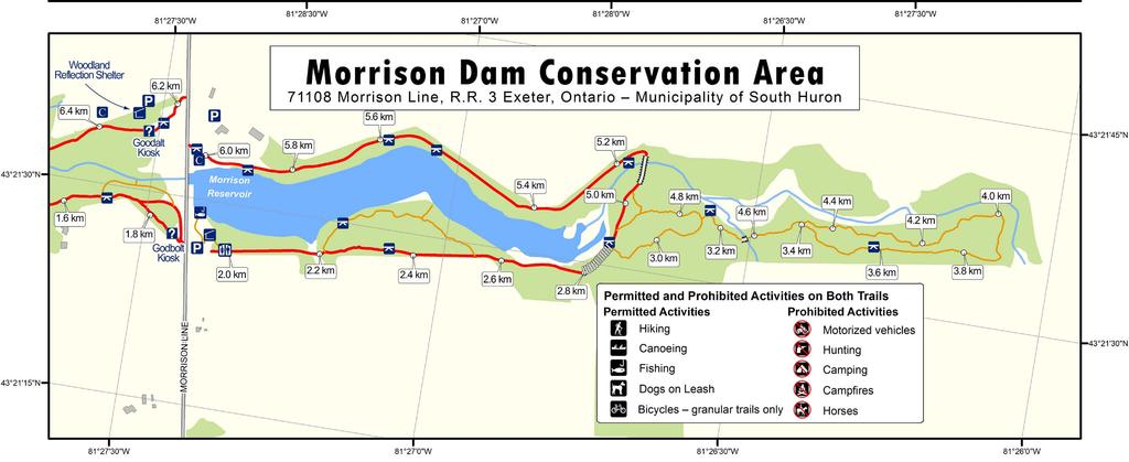
2 2 The South Huron Trail The South Huron Trail is an eight-kilometre, allseason trail that winds through the scenic Ausable River Valley. This accessible trail links MacNaughton Park in Exeter, Ontario and Morrison Dam Conservation Area (MDCA), at Morrison Line, just two kilometres (km) east of Exeter. The South Huron Trail combines the MacNaughton-Morrison and MDCA trail sections. Thanks to trail loops of different lengths (2 km, 4 km, or 8 km), you can spend 20 minutes or two hours enjoying nature. The trail is home to many community events and charitable fundraisers including the South Huron Trail Run, which includes competitive and fun runs and attracts people from Canada and the United States. Trail Markers There are 40 trail markers placed every 200 metres along the trail for eight kilometres. The trail marker locations are on the maps in this brochure. These markers are helpful ways to stay aware of where you are on the trail. You may also use those trail markers to help find plants and sites of interest on your tour. The MacNaughton Park kiosk marker is 0.0 metres and the numbers increase from there as it loops around the trail to the 8.0 kilometre (km) marker. The trail marking posts start at MacNaughton Park, at 62 MacNaughton Drive, in Exeter, and are located along the trail on the south side of the river, through Morrison Dam Conservation Area to the east end of the trails and back to MacNaughton Park on the north side of Morrison Reservoir and the Ausable River. Washrooms There are privies located south of Morrison Reservoir (Morrison Lake), along the Morrison Dam Conservation Area Section of the Trail. These restrooms are marked on the map in this brochure. Washrooms in MacNaughton Park are available seasonally. Morrison Dam Conservation Area

3 3 MacNaughton-Morrison Trail The MacNaughton-Morrison Section of the South Huron Trail passes through towering hardwood and pine forests, skirts along the Ausable River, and gives a bird s eye view of the river valley at several lookouts. This all-season trail is four kilometres long. The 75-metre Stirling Bridge spans the Ausable River mid-way between MacNaughton Park and Morrison Dam. Lookouts, including the tree-top boardwalk, provide scenic vistas of the forest, river valley, or golf course. Benches allow you to pause and enjoy the sights and sounds of nature. Education kiosks identify the birds and animals that call the corridor home. Location of MacNaughton Park MacNaughton Park in Exeter, Ontario is where you will find the start of the MacNaughton-Morrison Trail. The park is located at 62 MacNaughton Drive. A parking lot is located at the end of Hill Street, near these coordinates: N W Morrison Dam Conservation Area Trail Shaded, accessible nature trails surround Morrison Reservoir (Morrsion Lake) for hiking, running, birdwatching, bicycling, cross-country skiing, and nature appreciation. The 30-acre lake, located two kilometres east of Exeter, is a favourite spot for family fishing. Morrison Dam Conservation Area is owned and operated by Ausable Bayfield Conservation Authority (ABCA). Location of MDCA Trail The start (or trailhead ) of the Morrison Dam Conservation Area Section of the South Huron Trail is located at Morrison Line, RR 3 Exeter, near these coordinates: N W
; Ausable Bayfield Conservation Foundation; Exeter Lions Club; Municipality of South Huron; local landowners; and other donors, including service organizations,")
4 4 History of the South Huron Trail The MacNaughton-Morrison Section of the South Huron Trail was constructed between 2002 and 2004 through a community partnership that included Ausable Bayfield Conservation Authority (ABCA); Ausable Bayfield Conservation Foundation; Exeter Lions Club; Municipality of South Huron; local landowners; and other donors, including service organizations, businesses, and individual people. Check out the entrance kiosks for logos of some of the funding partners. Stirling Bridge Stirling Bridge was created with funding from Ontario Trillium Foundation and a family memorial donation. The Stirling Bridge name comes from Scottish history and was featured in the movie Braveheart. The former Ausable River Conservation Authority, Ontario s first conservation authority, was formed in Its original mandate was the protection of life and property from flooding and that remains a key mandate of Ausable Bayfield Conservation Authority today. ABCA owns more than 9,500 acres of land in the watershed for conservation purposes. Construction of Morrison Dam and Morrison Reservoir began in 1956 and was completed by The dam was built to ensure water supply for the former Exeter Canning factory. Although the dam is not used for that purpose now, the conservation area has become a thriving lake ecosystem. Morrison Reservoir is also known as Morrison Lake. Ausable Bayfield Conservation Authority continues to run and maintain the dam. Although no formal attendance records are kept, it is estimated that thousands of people use the conservation area for recreation annually with hiking and fishing as the main activities. Please be sure to be aware of Ontario fishing regulations and follow those rules.


5 5 Flora and Fauna The South Huron Trail is a great place to find and learn about flora (plants and trees) and fauna (birds and other animals). The South Huron Trail offers excellent habitat because it provides three essential elements for wildlife food, water, and shelter. Check out the education kiosks along the trail to find out more. The South Huron Trail is within the Ausable River Valley. The headwaters are near Staffa and the river enters Lake White Squirrel Huron at Port Franks. The variety of aquatic life makes the Ausable River one of the richest watersheds of its size in Canada. The river, trees, birds, and wildlife, along the South Huron Trail, make this an ideal setting for a nature trail. It s also one of the best places to meet the area s distinctive white squirrels. You may also encounter beavers and other animals. The trail provides health, recreational, and social benefits and also nature appreciation. Birds The South Huron Trail is a great place to see or hear a number of bird species. They include: Blue Jay Eastern Screech Owl Great Blue Heron Green Heron Northern Oriole Red-winged blackbird Rose-breasted Grosbeak Green Heron Warblers Record birds you saw on trail:

6
7

8 6 South Huron Trail 62 MacNaughton Drive Exeter, Ontario Celebrating Ten Years 2004 to and beyond! Contacts: Ausable Bayfield Conservation Toll-free: Websites: Ausable Bayfield Conservation: abca.on.ca Municipality of South Huron: southhuron.ca municipal.southhuron.ca/trails abca.on.ca/page.php?page=south-huron-trail southhurontrail.com Most of the MacNaughton - Morrison Trail is on private property and this project is only possible because the landowners allow the trail to cross their properties. Please show your respect by staying on the marked trails. Thank you. This brochure is a project of the community committee for the 2014 Tenth Anniversary of the MacNaughton-Morrison Section of the South Huron Trail Please keep this brochure or pass it on! That helps to save paper, save money, and reduce waste. Photos courtesy Bonnie Sitter, David Bishop, Jim O Toole, Ausable Bayfield Conservation Many thanks to the Exeter Lions Club for printing of this brochure.

 Blue Cohosh (Caulophyllum giganteum) Bloodroot (Sanguinaria canadensis)")
 Mayapple (Podophyllum peltatum) Red Trillium (Trillium erectum) Trillium (Trillium, Wakerobin, Tri flower, Birthroot) (Did you know that pink")
9 7 Woodlands Trees you may find along the South Huron Trail include hardwood forests, plantations, and valleyland trees. Tree species here include: Basswood Beech and Blue Beech Black Cherry Black Maple Hemlock Ironwood White Pine Plants You may find wildflowers along the trail and other plants such as Chokecherry (Prunus virginiana). (Did you know some parts of the chokecherry are poisonous?) Be careful of poison ivy during your hike. Hopefully most of the plants you find will be more pleasant encounters such as: Astor/Aster (Asteraceae) Blue Cohosh (Caulophyllum giganteum) Bloodroot (Sanguinaria canadensis) False Solomon s Seal (Maianthemum racemosum) Jack-in-the-Pulpit (Arisaema triphyllum)... and Jill-in-the-Pulpit! Marsh Marigold (Caltha palustris) Mayapple (Podophyllum peltatum) Red Trillium (Trillium erectum) Trillium (Trillium, Wakerobin, Tri flower, Birthroot) (Did you know that pink trilliums are just more mature white trilliums? ) Wild strawberry (Fragaria virginiana) At the water s edge and in the marshy areas, cattails, sedges, and rushes grow. Red Trillium


10 8 Donations We hope you enjoy the MacNaughton-Morrison and Morrison Dam Conservation Area sections of the South Huron Trail. The South Huron Trail is maintained for your enjoyment, thanks to your donations. The trail is funded by the Exeter Lions Club, Ausable Bayfield Conservation Foundation, Municipality of South Huron, and community-minded citizens, businesses, and groups. Donations to the trail can be made through the Ausable Bayfield Conservation Foundation or online. Charitable gift receipts for income tax purposes are provided. It took more than half a million dollars to create the MacNaughton-Morrison Section of the South Huron Trail. This money was raised through community donations and in-kind contributions. Continued fundraising is needed to maintain the trail. Donate now or find out how you can support fundraising efforts so people can continue to enjoy the health, recreational, social, and economic benefits of this accessible trail. Enjoy the Woodland Reflection Shelter pavilion, shown on the map, near the trail entrance off Morrison Line. This is a place to reflect, enjoy nature, and remember loved ones. South Huron Trail Mobile The South Huron Trail Mobile was created in 2006, thanks to a donation from the family of the late Gordon Strang. The Trail Mobile gives people with limited mobility the chance to experience nature along the trail. There is no charge. Continued public donations make it possible for this service to continue. This modified electric golf cart is driven by volunteer drivers and gives people who could not otherwise walk the trail the opportunity to experience it. Contact Ausable Bayfield Conservation at or toll-free at to book your ride. (Rides are subject to weather and volunteer availability).
 are not permitted.")
11 9 Trail Rules and Etiquette Trail rules are in place for protection and enjoyment of you and your fellow users of this multi-use trail. These rules must be followed. Multiple fines can be enforced to anyone who does not. Motorized vehicles (except wheelchairs, etc.) are not permitted. If you have a dog on the trail, you must keep the dog on a leash, under control, and clean up after your dog. Please see signs for uses that are permitted and prohibited. Check the entrance sign boards at the entrance kiosks to confirm permitted uses. For your safety, the safety of all trail users, and to protect land and water, we also ask you to follow the trail etiquette. Promote safe and responsible trail use. Be courteous to others. Share the trail. Keep on the right, pass on left. Be a safe cyclist. Cycle slowly, give right-of-way to hikers, use a bicycle bell to warn hikers, be cautious at curves, and wear a helmet. Stay on the trail and respect neighbouring landowners. Be a friend of the environment. Enjoy the plants, trees, and wildlife but leave them for others to enjoy. Know the safety rules and wear appropriate equipment for your preferred trail activity. Be careful during wet and icy conditions. Keep the trail a pleasant place to visit. Don t litter. Please report vandalism and incidents to the Ausable Bayfield Conservation Authority (ABCA) at or toll-free
Rabbit Lake. Recreational Trail. Tour Guide
 Rabbit Lake Recreational Trail Tour Guide Rabbit Lake Trail RABBIT LAKE RECREATIONAL TRAIL HISTORICAL WALKING TOUR The Rabbit Lake Trail system is partially inclusive, accessible and paved. This trail
Chapter 1: Introduction
 Chapter 1: Introduction 1.0 The Report Card 1.0.1 Background People are becoming more aware of environmental issues locally and globally and want to know what they can do to improve their local watersheds.
Visitor Guidelines for WPC-owned Properties. Last revised 5/20/2010
 WESTERN PENNSYLVANIA CONSERVANCY Visitor Guidelines for WPC-owned properties 800 Waterfront Dr., Pittsburgh, PA 15222 412-288-2777, www.waterlandlife.org Visitor Guidelines for WPC-owned Properties Last
Groton Open Space Association s AVERY FARM EXPLORER GUIDEBOOK
 Groton Open Space Association s AVERY FARM EXPLORER GUIDEBOOK AVERY FARM DESCRIPTION: Called one of the most biologically diverse and valuable conservation sites in eastern Connecticut, this beautiful,
The Ontario Soil Conservation & Environmental Protection Assistance Program
 Location / Folder Title Description/Publisher Type Year The Ontario Soil Conservation & Environmental Protection Assistance Program Ontario Ministry of Agriculture and Food Wildflowers are like people
Mountain along Highway 80 Knott County
 Ever tried to climb an east Kentucky mountain? Unless you are a mountain goat, you will find it next to impossible. Mountaintop mining has opened up our mountains and given both humans and animals a place
Minong Area Ski Trails
 Minong Area Ski Trails 7. Beaver Brook Ski Trail Spooner College Street Park Spooner 14. Douglas County Ski Trails Solon Springs 18. Hatchery Park Trail Hayward Hayward Golf Course Hayward 20. Heartwood
holly tree Wellhill Farm Woodyard Bramham House red kites Round House ha-ha
 This 6.4 mile walk around the magnificent Bramham Park Estate has been made possible with the active support of the owner of the Estate, Nick Lane Fox, with funding from Natural England, as part of Defra
Maryland Chapter Trout Unlimited Brook Trout Conservation Effort
 Maryland Chapter Trout Unlimited Brook Trout Conservation Effort Photo by Matt Kline Portfolio of Recent Work MDTU Brook Trout Conservation Coordinator: Scott C. Scarfone, ASLA sscarfone@oasisdesigngroup.com
Great Bay National Estuarine Research Reserve Field Notes Summer 2010 Welcome
 Great Bay National Estuarine Research Reserve Field Notes Summer 2010 Welcome Welcome to the spring edition of Field Notes, a newsletter just for our Great Bay Community Land Stewards. Spring certainly
Foundation offers student award
 Page 1 of 10 We appreciate your interest in the work of landowners and other partners, like you, who are creating healthier Ausable Bayfield watersheds. This newsletter is to let you know about opportunities
Castlemorris Wood Walk
 Castlemorris Wood Walk Trail Tips This walk is one of a range of scenic walks developed by trailkilkenny and designed to allow you explore more of the great outdoors; bringing Kilkenny s wonderful countryside
Watershed News Ausable Bayfield Conservation Authority MARCH 1, 2006 THIRD ISSUE
 Watershed News Authority MARCH 1, 2006 THIRD ISSUE www.abca.on.ca 235-2610 1-888-286-2610 Montreal sportscaster returning home to host Conservation Dinner on April 27 Randy Tieman, who has just been announced
WALKABILITY CHECKLIST How walkable is your community?
 WALKABILITY CHECKLIST How walkable is your community? Everyone benefits from walking and other forms of active transportation. These benefits include: improved fitness, cleaner air, reduced risks of certain
Lamprey Rivers Advisory Committee (LRAC) Annual Report FY 2017 (Oct. 1, 2016 Sept. 30, 2017)
 Annual Report FY 2017 (Oct. 1, 2016 Sept. 30, 2017)") Lamprey Rivers Advisory Committee (LRAC) Annual Report FY 2017 (Oct. 1, 2016 Sept. 30, 2017) Participants on the Lamprey River Eco-paddle Photo courtesy of Peter Sawtell We are pleased to feature an outreach
Lamprey Rivers Advisory Committee (LRAC) Annual Report FY 2017 (Oct. 1, 2016 Sept. 30, 2017) Participants on the Lamprey River Eco-paddle Photo courtesy of Peter Sawtell We are pleased to feature an outreach
Heartwood Forest, in Sandridge, Hertfordshire, is a place where everyone can find space, peace, wildlife and miles of beautiful woodland to explore.
 Heartwood Forest Accessibility Statement September 2016 Purpose: This accessibility statement outlines the available facilities and access information for Heartwood Forest. Welcome We, the Woodland Trust,
Managing Public Forests for Wildlife
 Ruffed Grouse Society (PEI) Managing Public Forests for Wildlife A Presentation to the Discussion Meetings, Forest Policy Initiative, Public Forest Council March 2-2005 Presented by Jack MacAndrew, RGS
Detailed Descriptions and Maps of Woodside s Nature Trails
 Detailed Descriptions and Maps of Woodside s Nature Trails Access Mill Road Trail Park along Anderson Mill road. Signs on West Pleasant Colony and Anderson Mill road clearly point to the beginning of the
Macutagon Creek to Russell s Landing
 Day Trips Macutagon Creek to Russell s Landing Manitouwadge Public Consultation Committee Canoe Route #13 #13 MACUTAGON CREEK TO RUSSELL S LANDING This route is suitable to all levels of paddlers but due
Archives of Michigan Location: Accession No. OCLC No.
 Location: Accession No. OCLC No. 7/21/3 756870091 Location Guide Total Quantity: 7 manuscript (3.5 linear feet) Date Received: 3/22/2011 Date Prepared: 10/13/2011 Department: Dept. of Natural Resources
RESTORING 400 ACRES OF TIDAL MARSH IN THE SNOHOMISH RIVER DELTA
 RESTORING 400 ACRES OF TIDAL MARSH IN THE SNOHOMISH RIVER DELTA Marya Moses, Danny Moses, Neil Moses, and Robert Moses fish on Tulalip Bay, near the mouth of the Snohomish River Estuary. QWULOOLT IS A
Rebirth of the Pigeon River: Song of the Morning Dam Removal Project
 Major funding for this project was provided by: Michigan Department of Natural Resources Aquatic Habitat Grant Program $293,000 Golden Lotus, Inc. $100,000 Great Lakes Fishery Trust $46,000 Pigeon River
Electric Bicycles (E-Bikes)
") Electric Bicycles (E-Bikes) Advisory Board Recommendation May 15, 2017 1 Current City of Durango Regulations on Electric Bicycles In April 2016 the City of Durango Code of Ordinances was revised to clarify
Electric Bicycles (E-Bikes) Advisory Board Recommendation May 15, 2017 1 Current City of Durango Regulations on Electric Bicycles In April 2016 the City of Durango Code of Ordinances was revised to clarify
Fill in the rating for each section. Total up the ratings to see how your neighbourhood scores overall for walkability.
 WALKABILITY CHECKLIST How walkable is your community? Everyone benefits from walking and other forms of active transportation. These benefits include: improved fitness, cleaner air, reduced risks of certain
Water vole presentations notes
 Water vole presentations notes Slide One Hello everyone, my name is and I work for the Norfolk Wildlife Trust. The Norfolk Wildlife Trust is a conservation charity. Our job is to care for and to protect
2112 Behan Road Crystal Lake, IL 60014
 McHenry County Conservation District Prairieview Education Center Field Trip 2112 Behan Road Crystal Lake, IL 60014 Name Winter Ecology Schedule 10:00-1:30pm Tracks Not Commonly Found at PEC 10:00 10:20
Chapter 8 3 MILLION REASONS TO HUNT IN THE ADIRONDACKS
 Chapter 8 3 MILLION REASONS TO HUNT IN THE ADIRONDACKS It happens all the time - the place you've hunted since you were a child is suddenly no longer available to you. The property has changed hands and
The Value of Springs to The Petersen Ranch
 The Value of Springs to The Petersen Ranch Location 60 miles SW of Austin 50 miles North of San Antonio 12 miles West of Blanco 18 miles SE of Fredericksburg 8 miles SW of Luchenbach Ranch Overview 800
Hatfield Marine Science Center Nature Trail Quest
 Hatfield Marine Science Center Nature Trail Quest 118 The Oregon Coast Book, 2019 20 Edition South Beach NOAA Marine Operations Center Marina Store HMSC HMSC Tsunami Sustainability Quest Quest START START
2012 North Ottawa Dunes Deer Management Hunt. Rules and Regulations
 2012 North Ottawa Dunes Deer Management Hunt Rules and Regulations You MUST read and agree to abide by all of the rules listed below. All participants must comply with all Michigan DNR rules and regulations
2018 ROSE OF HOPE 20th ANNUAL CHARITY GOLF TOURNAMENT TUESDAY, JULY 31st, 2018 SPONSORSHIP INFORMATION
 2018 ROSE OF HOPE 20th ANNUAL CHARITY GOLF TOURNAMENT TUESDAY, JULY 31st, 2018 SPONSORSHIP INFORMATION Tour Sponsor: $5000 Entitlements Your company name and logo on all scorecards Complementary golf foursome
 Time of Change We Are Growing We Are An Attractive Place To Live We Are Age Diverse + Living Longer 50000 40000 30000 20000 10000 0 2010 Census Job Density Housing Sheds Transit Sheds The Project FUNDING
Guidelines for Public Use of WPC-owned Properties. Last revised 01/27/2017
 Guidelines for Public Use of WPC-owned Properties Last revised 01/27/2017 Properties owned by Western Pennsylvania Conservancy (WPC) are open to the public free-of-charge. Western Pennsylvania Conservancy
Broken Bar W Ranch TETON VALLEY, IDAHO. Hunting Ranching Fly Fishing Conservation
 Broken Bar W Ranch TETON VALLEY, IDAHO Hunting Ranching Fly Fishing Conservation Broken Bar W Ranch TETON VALLEY, IDAHO Introduction: The Broken Bar W Ranch is located in Driggs, Idaho, the county seat
All Season Age Friendly Pedestrian Safety and Walkability Checklist *
 FOSTERING AGE FRIENDLY, WALKABLE NEIGHBOURHOODS Walkability is a key component of optimal aging in Age Friendly cities. Walkable neighbourhoods promote physical and mental health and well-being, support
RAILWAY SAFETY. Please click on any of the links below to go directly to your specified topic within this document.
 RAILWAY SAFETY Please click on any of the links below to go directly to your specified topic within this document. Facts about Railway Property and Trains Railway Signs, Devices, and Warnings Railway Safety
Iowa Department of Natural Resources Iowa Water Trails Grant Program
 Iowa Department of Natural Resources Iowa Water Trails Grant Program Submitted by the City of Story City in conjunction with the Skunk River Paddlers and the Story County Conservation Board Tuesday, January
Spring Walking Weekend June 6, 7, and 8, Walk List
 Spring Walking Weekend June 6, 7, and 8, 2014 Walk List Friday, June 6 Barnstable Conservation with Yoga, West Barnstable from Service Rd 9:30 AM 2.5 miles, 1.5 hrs: Moderate Description: A leisurely hike
Hunting and Trapping Policy
 Hunting and trapping are allowed on certain Bangor Land Trust properties (see table below). Most Bangor Land Trust properties are located in an urban area and are important for wildlife habitat and available
MOUNTAIN BROW MULTI-USE PATHWAY FEASIBILITY STUDY
 MOUNTAIN BROW MULTI-USE PATHWAY FEASIBILITY STUDY March 27, 2018 City of Hamilton Project Manager: Louise Thomassin IBI Group Project Manager: Jennifer Moore Vision & Study Mandate STUDY MANDATE: to determine
Shifting Gears for a Healthier City.
 Shifting Gears for a Healthier City. Mississauga s Cycling Master Plan is an ambitious strategy that sets out to transform Mississauga into a city that is conducive to cycling for daily transportation
Santa Fe Dam Nature Center School Tours. Frank Bronzeagle Ayala
 Santa Fe Dam Nature Center School Tours Frank Bronzeagle Ayala 2014 our Nature Center has been host to 386 students. During these tours the students are taught about flora, fauna and history of the area.
Sandilands to Huttoft Bank
 Coastal Country Park Walks Sandilands to Huttoft Bank A CIRCULAR WALK OF 11KM (7 MILES) INTRODUCTION The Lincolnshire Coastal Country Park lies between Sandilands, Chapel St Leonards and Huttoft on the
EVENT GUIDE. Event Guide 1
 EVENT GUIDE Event Guide 1 Welcome to the V Foundation s Inaugural Victory Ride to Cure Cancer! Thank you for being a part of this special event. To prepare for the event and to know what to expect before,
Quartz Mountain Nature Park
 Quartz Mountain Nature Park Situated on the tranquil shores of Lake Altus- Lugert at the western end of the Wichita Mountain range, Quartz Mountain Nature Park is one of Oklahoma s premiere state parks.
2018 Volunteer Program Guide
 2018 Volunteer Program Guide Volunteers are vital to the success of Teller Wildlife Refuge! Thanks to your donation of time and support, Teller continues to save thousands of dollars annually while completing
ACTIVE TRANSPORTATION Active Community Checklist
 ACTIVE TRANSPORTATION Active Community Checklist Safe, accessible spaces to walk, hike, bike and play is an important part of building strong, healthy and active communities for residents and visitors.
One Truckee River Sparks City Council
 One Truckee River Sparks City Council What is the One Truckee River initiative? Working together for a sustainable, clean, thriving river community recognized in the hearts and minds of all for the treasure
Trails that Transform: The Economic Impact of Bicycle Tourism
 Trails that Transform: The Economic Impact of Bicycle Tourism September 2016 Economic Growth Summit Alta Planning + Design Nation s leading team of bicycle, pedestrian, greenways, and trails planning and
ROUTE 2. Bateau Channel. Topographic Map 31 C/8 Navigation Charts 1438/39 Reference Maps
 Topographic Map 31 C/8 Navigation Charts 1438/39 Reference Maps ROUTE 2 Bateau Channel The shoreline marshes of the Bateaux Channel team with life. Wetlands provide breeding habitat for amphibians, fish
Broaddus Loop. Lufkin & Angelina County Bicycle Route. Total Miles:
 Lufkin & Angelina County Bicycle Route Total Miles: 72.6 www.visitlufkin.com Route Directions: Segment Distance Direction of Total Distance Road Traveled (miles) Turn (miles) Start Lufkin High School
2. THAT the Mayor and Corporate Officer be authorized to execute all documents related to this matter.
 COUNCIL REPORT Report No. PRC 016-2016 EXECUTIVE COMMITTEE Date: March 2, 2016 File No: 6240-01 To: From: Subject: Mayor and Council Heidi Enns, General Manager, Parks, Recreation and Culture BikeBC Program
CELEBRATE FLORIDA PANTHER WEEK IN NAPLES
 News Release Florida Panther National Wildlife Refuge Ten Thousand Islands National Wildlife Refuge U.S. Fish and Wildlife Service 3860 Tollgate Blvd, Suite 300 Naples, FL 34114 Phone: 239/353-8442 CONTACT:
Utah. North Stansbury Mountains Wilderness Study Area Site-Specific Monitoring Guide
 Utah North Stansbury Mountains Wilderness Study Area Site-Specific Monitoring Guide 1 General Information WildSNAP Monitoring Peter Woodruff, American Conservation Experience Coordinator Phone (801) 989-7069
 Having trouble viewing this email? Click here Photo Credit Harvey Locke Website Board & Staff Goals Events Maps Archives Contact Jack Potter Award An Importan Year-End Message from Headwaters Montana's
AQUATIC WILD CORRELATIONS TO NORTH CAROLINA K-5 SCIENCE ESSENTIAL STANDARDS
 AQUATIC WILD CORRELATIONS TO NORTH CAROLINA K-5 SCIENCE ESSENTIAL STANDARDS NC Wildlife Resources Commission January 2015 www.ncwildlife.org/educators The following document is a listing of the K-5 Science
Track & Trail River Camp. South Luangwa National Park, Zambia
 Track & Trail River Camp South Luangwa National Park, Zambia Track & Trail River Camp Track & Trail River Camp is a privately owned lodge located on a breathtaking spot on the banks of the Luangwa River
The Little Miami National Wild & Scenic River
 Saving a National Treasure The Little Miami National Wild & Scenic River Little Miami Incorporated 6040 Price Road Milford OH 45150 1429 A 1910 Postcard of the Little Miami near Kings Mills OH Welcome
BOARD OF DIRECTORS MEETING. Thursday, May 16, Ausable Bayfield Conservation Authority Boardroom Morrison Dam Conservation Area
 M I N U T E S BOARD OF DIRECTORS MEETING Thursday, May 16, 2013 Ausable Bayfield Conservation Authority Boardroom Morrison Dam Conservation Area DIRECTORS PRESENT Burkhard Metzger, Lorie Scott, Don Shipway,
Rookery Bay National Estuarine Research Reserve. Team OCEAN at Rookery Bay
 Rookery Bay National Estuarine Research Reserve Team OCEAN at Rookery Bay What is Team OCEAN? Why have it at Rookery Bay? How is it implemented? Partnership + + National Estuarine Research Reserves Partnership
2017 Annual Charity Golf Tournament Sponsorship Opportunities
 2017 Annual Charity Golf Tournament Sponsorship Opportunities Charitable Registration# 11921 7081 RR0001 About Brantwood Community Services Brantwood Community Services is a not for profit agency that
2014 PA Resident Survey
 2014 PA Resident Survey Purpose: Understand outdoor recreation patterns and opinions regarding future recreation land conservation, facility development and management Provide a snapshot of where Pennsylvanians
Preserving Biological Diversity for Future Generations
 The U.S. Fish and Wildlife Service Preserving Biological Diversity for Future Generations Flavia Rutkosky US Fish and Wildlife Service Delaware Bay Estuary Bay Project Office Smyrna, Delaware BIOLOGICAL
2018 Annual Charity Golf Tournament Sponsorship Opportunities
 2018 Annual Charity Golf Tournament Sponsorship Opportunities Charitable Registration# 11921 7081 RR0001 About Brantwood Community Services Brantwood Community Services is a not for profit agency that
Completing the Puzzle: Conserving the Florida Keys Ecosystem One Parcel At a Time
 2007 Public Land Acquisition & Management Partnership Conference Completing the Puzzle: Conserving the Florida Keys Ecosystem One Parcel At a Time Anne Morkill Florida Keys National Wildlife Refuges Complex
The Lake Creek Ranch. Located in the foothills of the Owl Creek Mountains in western Hot Springs County, Wyoming
 The Lake Creek Ranch Located in the foothills of the Owl Creek Mountains in western Hot Springs County, Wyoming Experienced Professional Ranch Brokers Specializing in the sale of ranches, farms, & recreational
OREGON DEPARTMENT OF FISH AND WILDLIFE
 OREGON DEPARTMENT OF FISH AND WILDLIFE Ladd Marsh Wildlife Area 1 Benefits for all Oregonians 2 The Mission To protect and enhance Oregon's fish and wildlife and their habitats for use and enjoyment by
MUDDY WATERS RIDES AGAIN!
 MUDDY WATERS RIDES AGAIN! Table of Contents Cycling for Habitat how you are helping... 2 Ride Day Information for the 100 kilometre ride... 4 Cars/Bikes/Valuables @ Kildonan Park... 5 Fun @ the Finish
Greenway. Great Western A USER S GUIDE. Ireland s Longest Off-Road Walking And Cycling Route.
 Great Western Greenway www.greenway.ie A USER S GUIDE Ireland s Longest Off-Road Walking And Cycling Route EUROPEAN DESTINATION OF EXCELLENCE AWARD WINNER t o Escape the bustle of urban life on the 42km
Innsbrook Resort Golf Course
 Innsbrook Resort Golf Course YARDAGE GUIDE Depth: 36 yards 1par 4 Innsbrook Resort Golf Course is nationally recognized, having received a Four-Star Rating from Golf Digest, making our course the highest
Searsville Dam Removal
 Searsville Dam Removal A unique opportunity for all Presented by the Beyond Searsville Dam Coalition San Francisquito Creek flows into the San Francisco Bay near the Palo Alto Airport and Golf Course seen
RED RIVER NATIONAL WILDLIFE REFUGE
 RED RIVER NATIONAL WILDLIFE REFUGE http://www.fws.gov/refuge/red_river/ https://www.facebook.com/redrivernwr Photograph of wood ducks taken on Refuge by volunteer Ronnie Maum Wildlife Quiz 4 Bird Species
Labour. The Ontario Works program provided a total of 44 individuals for this year s Land Reclamation Program. rd
 6 2004 Activities Labour The Ontario Works program provided a total of 44 individuals for this year s Land Reclamation Program. rd These individuals participated 2 days a week over a 12 week period offered
Conserving the Forests, Lakes and Streams of Northeast Michigan
 4241 Old US 27 South, Suite 2, Gaylord, Michigan 49735 (989) 448-2293 www.huronpines.org info@huronpines.org Prioritized Restoration Projects in the AuSable River Watershed Summer 2015 Update from Huron
Walks in Chellow Dene
 City of Bradford Metropolitan District Council Leisure Services a breath of fresh air Walks in Chellow Dene In association with the Fairweather Green and Daisy Hill Action groups Chellow Dene Chellow Dene
ARkAnsAs tennessee Primary Partner: Primary Partner: Habitat Work: Habitat Work:
 Eastern Elk initiative david STEPhENSON Elk in the East On foggy mornings when the chill of fall is in the air, distant elk bugles ring sparsely through the hills and valleys of the East. Each one tells
B Buckmoth. Look quickly or you ll miss the buckmoth! These bold black and white moths fly quickly and for only a few weeks in the fall.
 A Z A Amphibians The Pine Bush is home to many different amphibians. This is the eastern spadefoot toad. Spadefoot toads have back feet shaped liked shovels used for digging backward into soft sand. If
Eastern Brook Trout. Roadmap to
 Eastern Brook Trout Roadmap to CONSERVATION Our Brook Trout heritage he wild Brook Trout is an American symbol of persistence, adaptability, and the pristine wilderness that covered North America prior
Minnesota TREK MINNESOTA TRAIL SELF-GUIDED TOUR 6TH - 8TH GRADE. Minnesota Trek 6 8th grades 1
 Minnesota TREK MINNESOTA TRAIL SELF-GUIDED TOUR 6TH - 8TH GRADE Minnesota Trek 6 8th grades 1 Welcome to the MINNESOTA ZOO Minnesota Trek Self-Guided Tour USE THE MINNESOTA TREK TO HELP YOU LEARN HOW...
Woods Creek Ranch DRIGGS, IDAHO
 Woods Creek Ranch DRIGGS, IDAHO Woods Creek Ranch DRIGGS, IDAHO Introduction: Woods Creek Ranch is a sportsman s paradise located in the heart of Teton Valley, Idaho, less than 3 miles from downtown Driggs
Toronto Wildlife Centre
 Toronto Wildlife Centre Toronto Wildlife Centre (TWC) is the only wildlife centre offering medical care and rehabilitation for sick, injured and orphaned wild animals in the GTA. TWC began operations in
Public Feedback Comments Appendix G. Appendix G. Public Feedback Comments. Virginia Beach Bikeways and Trails Plan 2011 Page G-1
 Public Feedback Comments Virginia Beach Bikeways and Trails Plan 2011 Page G-1 This is a complete collection to date of responses to the feedback survey which was used at public open houses in December
For Sale - Snow Lake Hunting & Fishing Club
 16429 Snow Rd. & Jackson Rd., Auburn, OH 44021 Introduction Snow Lake is a 282 acre private preserve located in rural Geauga County, Ohio. The property features a 32 acre natural glacial lake, wetlands,
OLD TIMES ON THE GRAND TOUR Package Itinerary & Details Summer 2018
 OLD TIMES ON THE GRAND TOUR Package Itinerary & Details Summer 2018 The Old Times on the Grand Tour is a Lodging & Learning package designed for those who want to enjoy some of the best experiences Yellowstone
Canoe Route. Dogtooth Lake-Highwind Lake-Dryberry Lake- Lake of the Woods-Blindfold Lake
 1 Canoe Route Dogtooth Lake-Highwind Lake-Dryberry Lake- Lake of the Woods-Blindfold Lake This is an interesting and challenging route starting and ending at Rushing River Provincial Park. It passes over
Bicycle Travel in Oregon
 Bicycle Travel in Oregon Top Outdoor Recreation Activities by Participation Rate Running, jogging & trail running 51.5 million Freshwater, saltwater & fly fishing 46.2 million Road biking, mt biking
WALK Friendly Communities: Creating Vibrant, Inclusive Places for People
 WALK Friendly Communities: Creating Vibrant, Inclusive Places for People Walkers are the indicator species for vibrant communities ~ Dr. Rodney Tolley, Director, Walk21 Imagine yourself walking safely
Zane Carter s Eagle Scout Project
 Zane Carter s Eagle Scout Project Newfield s Vernal Pools With support of BSA Troop 34 and in cooperation with: Town of Newfield, NY Upper Susquehanna Coalition Special thanks to: Melissa Yearick (USC)
Introduction to Pennsylvania s Deer Management Program. Christopher S. Rosenberry Deer and Elk Section Bureau of Wildlife Management
 Introduction to Pennsylvania s Deer Management Program Christopher S. Rosenberry Deer and Elk Section Bureau of Wildlife Management To anyone who has carefully studied the situation it is evident that
Shimmerhorn Ranch. Buford, Wyoming // Albany County
 Shimmerhorn Ranch Buford, Wyoming // Albany County The Shimmerhorn Ranch is located just off Interstate 80; it lies 20 miles east of Laramie, the home of the University of Wyoming, and 30 miles west of
Neighbourhood Walkability Checklist How walkable is your community?
 Template letter This template is a guide to writing to your local council. You can change it in any way you feel necessary. Don t forget to attach the checklist and any photographs, maps or sketches you
Landmark Heritage Trust
 Landmark Heritage Trust A land trust for the towns of Carmel Dixmont Etna Hampden Hermon Monroe Newburgh Winterport Volume 6, Issue 1 JANUARY 2012 FROM THE PRESIDENT S CORNER Tony DeFeo President Allan
QUEEN ELIZABETH SCHOOL PARK AND GLENGARRY PARK USAGE SURVEY RESULTS Integrated Strategic Development- Citizen Services- City of Edmonton
 QUEEN ELIZABETH SCHOOL PARK AND GLENGARRY PARK USAGE SURVEY RESULTS 2016 Integrated Strategic Development- Citizen Services- City of Edmonton Introduction Background and Objectives District Parks are busy,
WARKWORTH SKATEPARK PROPOSAL
 WARKWORTH SKATEPARK PROPOSAL SKATE the PARK OUR MISSION STATEMENT TO PROVIDE A SAFE, USABLE, ENJOYABLE AND ATTRACTIVE SKATEPARK FOR ALL RESIDENTS OF OUR COMMUNITY. WE INVITE OTHERS TO SHARE IN THIS WORTHWHILE
Sunday, June 14 th 9:30am Pine Cone Bird Feeders Meet Courtney at the Rec. Hall to learn how to make your own bird feeder out of pine cones.
 Fall Creek Falls Activities June 14 th 21 st Welcome to Fall Creek Falls State Park! Summer vacation time is here and what a great place to spend it! The park provides a wonderful opportunity to enjoy
Villa Rica Trail Master Plan
 Public Meeting April 18, 2018 v Presentation Outline Introductions & Benefits of Trails Master Planning Process Preliminary Findings Trail Branding Construction Standards Next Steps & Schedule PATH Planning
Shawnee Prairie Loop. Lufkin & Angelina County Bicycle Route. Total Miles: 38.
 Lufkin & Angelina County Bicycle Route Total Miles: 38 www.visitlufkin.com Route Directions: Segment Distance (miles) Direction of Turn Road Traveled Total Distance (miles) Start Lufkin High School (309
PRE-RACE CHECKLIST WHAT TO BRING
 PRE-RACE CHECKLIST Review race website chasethecoyote.com for race day information. Review course maps and aid station locations. Review parking information (new instructions this year). Allow extra time
2018 Sponsorship Opportunities
 2018 Sponsorship Opportunities Be a part of history. Support environmental stewardship! July 28, 2018 The 64 km Mattawa River Canoe Race tests marathon racers skill, strength and stamina as they paddle
Right of public access a unique opportunity
 1 Right of public access a unique opportunity Don t disturb don t destroy The right of public access is a fantastic opportunity for all of us to roam freely in nature. You make use of the right of public