Report. on the. Reverse Circulation Drilling. of the. Moose Deposit. Fireside Minerals. Covering portions of Lease and Claim (Lynx 1)
|
|
|
- Phebe Porter
- 5 years ago
- Views:
Transcription
1 Report on the Reverse Circulation Drilling of the Moose Deposit of Fireside Minerals Covering portions of Lease and Clai (Lynx 1) Situated at Kiloeter 880 of the Alaska Highway Liard Mining Division N.T.S. 94M/14 Latitude N Longitude W Report by E.W.Craft P.Eng. February 25, 2013
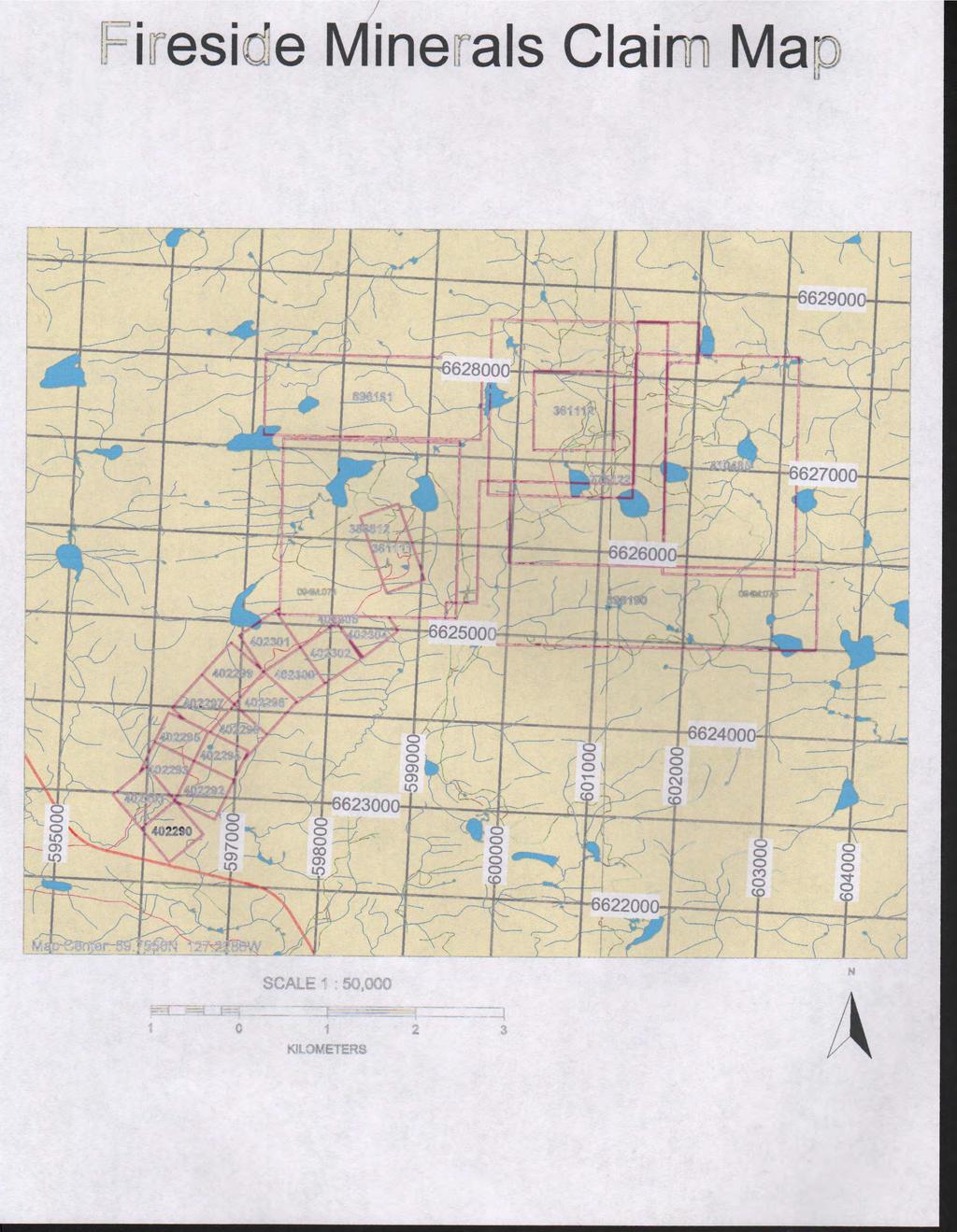
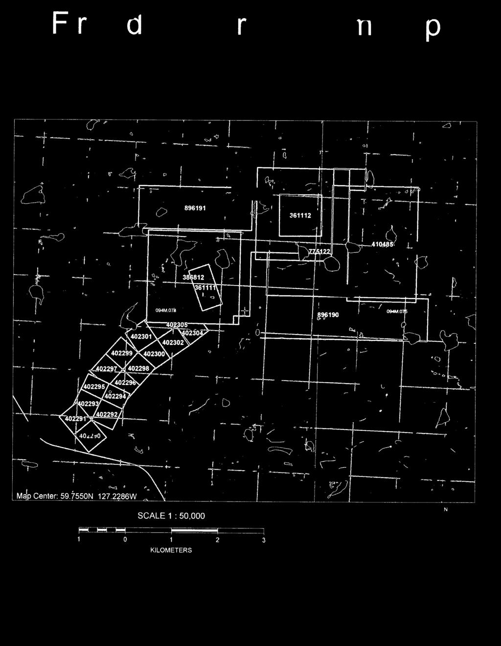
2 Table of Contents Page Introduction 2 Suary and Conclusions 2 Location and Access 2 Clais 2 General Setting 3 Local Geology and Mineralization 3 Progra 4 Results 4 Assessent Details 5 Certificate 6 Appendices Appendix 1 1 Location Map 2 Clai Map 3 Moose Plan Appendix 2 Drill Hole Sections Appendix 3 Drill Hole Logs 1
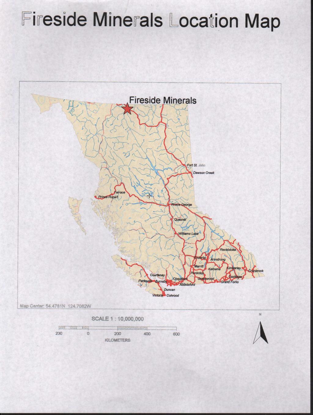
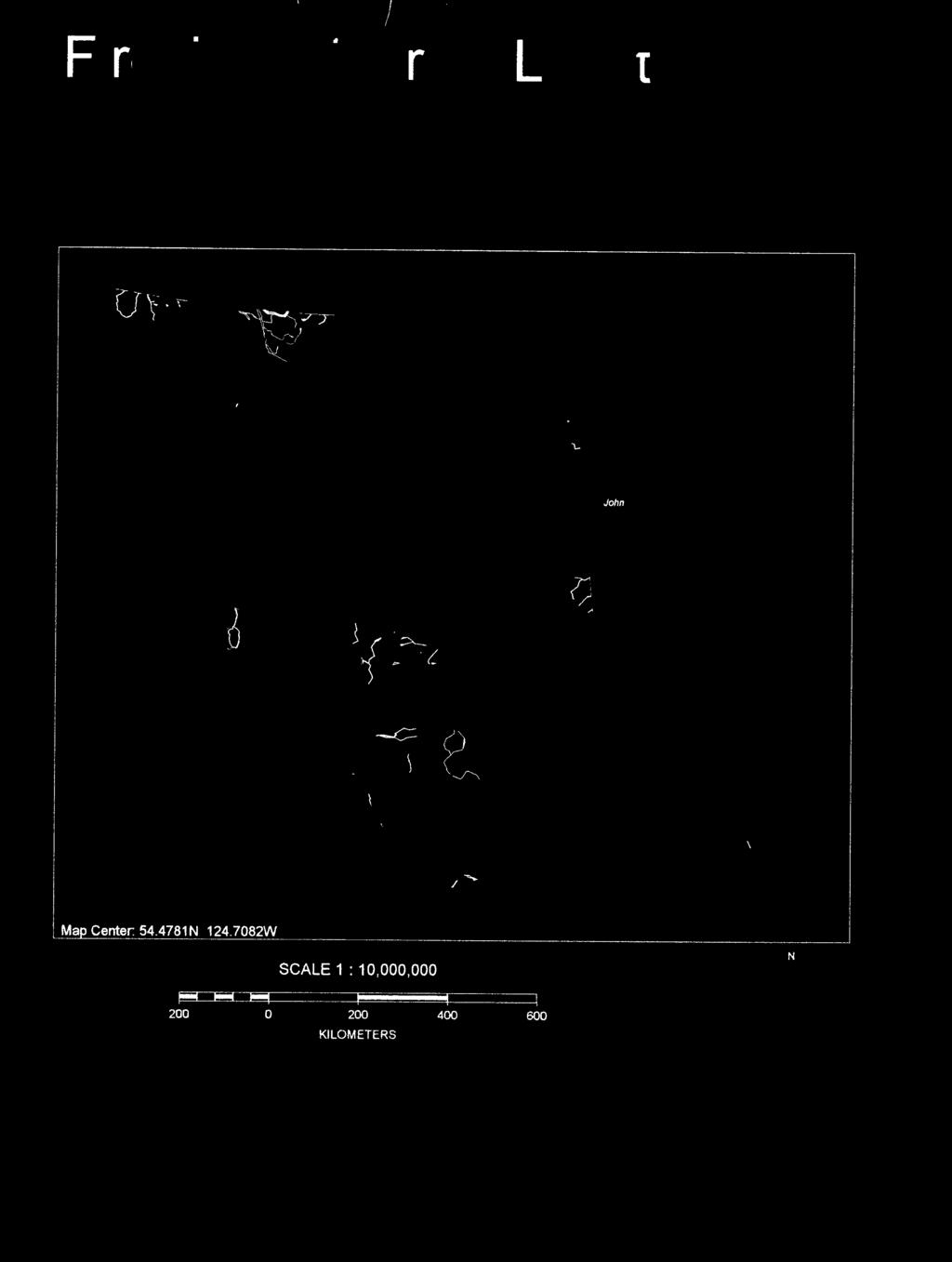
3 Introduction In 2012 it was decided to use Reverse Circulation drilling as a preliinary exploration tool. The ain goal of the progra was to extend the Moose barite veins to the north. Most of the drilling was done on the Moose Production Lease (361111) with the last 2 holes drilled off of the lease on the Lynx 1 Clai (386812). This report covers the drilling on both tenures. I was on site April 27 th to May 1 st to ark up the locations of the drilling and again on August 21 st to August 26 th to review the drilling and do the final pick-ups. Suary and Conclusions A total of 18 Reverse Circulation Holes were drilled on the Moose Production Lease and the Lynx Clai for a total of eters. Only two of the holes were drilled on the Lynx Clai. The reverse circulation drilling is a cheaper and faster ethod than diaond drilling for getting preliinary subsurface inforation but it has liited value in quantifying a resource. Reverse circulation drilling does give soe stratigraphic inforation but no structural inforation. This drilling does position the resource geoetrically and provide enough data to do a rough estiate on the resource potential. The drilling progra did extend the veins 220 to the north and the veins appear to be thick enough to ine by open pit ethods. A diaond drill progra in 2013 will evaluate the resource farther. Location and Access The Moose Deposit is located on the Liard Plain approxiately 6 k. north of the Alaska Highway near Kiloeter 880. The location is shown on the Location Map in Appendix 1. The deposit is located at Lat N and Long W. Clais Access is by a good 6k gravel road off of the Alaska Highway at K The Fireside Property is ade up of the following clais as well as the Bear and the Moose Production leases. The Moose Deposit is located on the Moose Production Lease and the Lynx 1 Clai. The clais are shown on the Clai Map in Appendix 1. Tenure Nuber Type Clai Nae Good Until Area (ha) Mineral LYNX Mineral RAM Mineral RAM
4 General Setting Mineral RAM Mineral RAM Mineral RAM Mineral RAM Mineral RAM Mineral RAM Mineral RAM Mineral RAM Mineral RAM Mineral RAM Mineral RAM Mineral RAM Mineral RAM Mineral RAM Mineral RAM Mineral RAM Mineral RAM Mineral RAM Mineral RAM Mineral RAM The Moose deposit lies on the Liard Plain of Northeastern B.C. at an elevation of approxiately 750.The ground surface is covered by second growth Lodgepole Pine and Tag Alder. The bedrock geology is a thick sequence of Cabrian and Precabrian siltstones. Geology and Mineralization The Moose veins are contained within a north trending fault zone that dips steeply to the west. The Barite veins pinch and swell both along strike and dip. For this reason it is necessary to have fairly close spaced inforation in order to do a reliable job on a resource estiate. The Moose veins have been ined to a shallow depth for approxiately 450 on the southern end with the production of about 80,000 tonnes of Barite. The Barite is of good quality with a low base etal content. The location of the historical work (1985 and earlier) is only approxiate. The locations are referenced to an exploration grid that was established in 1966 and I have been unable to locate it on the ground. The historical is also incoplete. 3
5 Progra The exploration progra was all reverse circulation drilling which was carried out in 3 short capaigns between May 12 th and July 30 th. A total of 18 holes were drilled on 9 sections. The locations of the holes are shown on the Moose Plan contained in Appendix 1. The drilling was done by Fireside Minerals personnel using a drill owned by the copany. The drill produces a 63 diaeter hole. Results The drilling progra was successful in extending the barite veins north to Latitude 6,626,402N. The veins have been located sufficiently so that a Diaond drill progra can be located to obtain a axiu aount of worthwhile data. While the veins are identified with reverse circulation drilling their location is not precise as there is bound to be soe wandering of the holes, which is indeterinate. The data obtained by this drilling does give soe lithological inforation but no structural inforation. The thickness of the intersections is open to interpretation as I have tried to deonstrate on Section 6,626,247N. One interpretation is shown on the top side of the hole plot and another on the lower side. The holes in the Moose Zone were designed to extend the zone to the north. All of the holes up to and including RC12-18 were drilled on the Moose Mining Lease (361111) while holes RC12-19, 20 were drilled on the Lynx 1 MC (386812). Holes RC 12-01, 02 were drilled on Section 6,626,211N. The upper hole hit a coercial section of Barite the lower hole did not. Holes RC 12-03, 04 were drilled on Section 6,626,196N. These holes were drilled below an exposed Barite outcrop. The upper hole hit a coercial intersection of Barite while the lower hole hit a narrower intersection. Holes RC12-05, 06 were drilled on Section 6,626,180N. Both holes hit coercial intersections of Barite. Hole RC12-07 was drilled on Section 6,625,708N. This hole was to deterine the southern liit of the Moose Zone. This hole did not intersect any Barite. Hole RC12-10 was drilled in the wrong direction and accoplished nothing. Holes RC12-11, 12 were drilled on Section 6,626,247N. Both holes hit coercial intersections of Barite. Holes RC12-13, 14 were drilled on Section 6,626,273N. Both holes hit coercial intersections of Barite. 4
6 Holes RC12-15, 16 were drilled on Section 6,626,303N. Both holes hit coercial intersections of Barite. Holes RC12-17, 18 were drilled on Section 6,626,333N. These holes did not hit any significant Barite. It is quite probable that they hit a fault gap in the syste. Holes RC12-19, 20 were drilled on Section 6,626,402N. The upper hole hit a significant Barite intersection but the lower hole did not. These holes were probably started too far to the west and as a result the lower hole was not drilled deep enough to get an intersection. The drilling progra was supervised by Scott Allan who also logged the cuttings. Scott Allan is currently copleting his final year towards a B.Sc. Degree in Geology fro the University of Calgary. The Sections of the drilling are contained in Appendix 2 and the logs in Appendix 3. Exploration and Developent Work on Lynx 1(386812) Costs for drilling and recording RC & 20 Access and site preparation Dozer and Excavator 15 $100/hr. $1500 Drilling $5558 Surveying and Logging $1000 Report preparation $100/hr. $1500 Total $9558 5

7
8 Appendix 1 Maps
9
10
11 RC 12-19(-45) RC 12-20(-64) DD66-31(-90) 6,626,400N Lynx 1 386,812 DD66-28(-90) 6,626,350N RC 12-17(-45) DD66-32(-90) Moose 13 & 14 MC D. L Lease RC 12-18(-64) DD66-30(-90) RC 12-15(-45) RC 12-16(-64) DD66-25(-90) RC 12-14(-45) RC 12-13(-64) RC 12-12(-64) DD66-24(-45) RC 12-11(-45) DD66-27(-90) DD66-29(-90) 6,626,300N 6,626,250N RC 12-10(-64) RC 12-01(-45) RC 12-02(-64) RC 12-03(-45) RC 12-04(-64) 6,626,200N MK 73-15(-45) Proposed Diaond Drill Sites 2013 & 2014 Details shown on sections RC 12-05(-45) RC 12-06(-60) MK 73-13(-45) MK 73-14(-70) MB 85-8 (-50) MB 85-7 (-51) MK 73-12(-50) MB 85-9 (-50) DD66-24(-90) DD66-20(-90) DD66-21(-90) DD66-22C(-80) M 71-1(-60) MK 73-10(-45) MK 73-16(-45) M 71-2(-60) M 71-3(-73) 6,626,150N 6,626,100N 6,626,050N MK 73-11(-45) MK 73-17(-45) X66-21(-45) MK73-18(-45) DD66-18(-90) DD66-17(-90) MK 73-20(-45) 6,626,000N MK 73-21(-45) X66-23(-45) X66-22(-30) DD66-19(-87) X66-11(-45) 6,625,950N MB 85-6 (-45) MK 73-8(-45) MK 73-22(-45) X65-M3(-45) X66-9(-87) X66-10(-45) MB 85-5 (-49) DD66-8(-90) DD66-7(-90) MB 85-4 (-50) DD66-6(-90) MB 85-3 (-45) 6,625,900N MK 73-9(-60) MK 73-5(-60) DD66-13(-90) X66-7,8 DD66-5(-90) MK 73-7(-77) MK 73-6(-60) 6,625,850N DD11-04 DD11-05 DD11-06 X65-?(-90) X65-?(-45) DD66-11(-90) DD66-10(-90) DD66-12(-90) DD66-4(-90) MK73-23(-90) DD66-2(-90) DD66-9(-90) DD66-1(-90) X66-1(-22) MK73-1(-45) MK73-2(-60) MB 85-2 (-45) MB 85-10(-45) MK 73-4(-45) DD05-11(-45) DD11-03(-45) MK 73-3(-45) DD11-02(-45) DD05-10(-45) DD11-01(-45) DD05-09(-45) DD11-14(-45) 6,625,800N 6,625,750N DD11-15(-45) DD66-3(-90) MB 85-1(-45) Jig Recycl 6,625,700N 6,625,650N 6,625,600N 598,250E 598,300E 598,350E 598,400E 598,450E 598,500E 598,550E 598,600E FIRESIDE MINERALS Moose Pit 598,650E 0 Scale 100 Drawn by Date Scale Revision 598,700E 598,750E E.W.Craft Noveber 2011 Reference 1 : 1000 Drg No: Noveber ,800E 6,625,550N UTM NAD 83
12 Appendix 2 Drill Hole Sections
13 RC12-07(-45) 750 Black Argillite ,700 E ,550 E 598,600 E ,650 E FIRESIDE MINERALS Moose Pit Section 6,625,708 N Drawn by EWC Date Nov Scale 1 : 500 Ref. UTM NAD 83 Revision Scale Meters
14 RC 12-05(-45) RC 12-06(-60) Legend Barite 100% Barite +60% 598,700 E ,550 E 598,600 E ,650 E FIRESIDE MINERALS Moose Pit Section 6,626,180 N Drawn by EWC Date Nov Scale 1 : 500 Ref. UTM NAD 83 Revision Scale Meters
15 RC 12-03(-45) RC 12-04(-64) Legend Barite 100% Barite +60% ,550 E 598,600 E 598,650 E FIRESIDE MINERALS Moose Pit Section 6,626,196 N Drawn by EWC Scale 1 : 500 Date Nov Ref. UTM NAD Revision Scale Meters ,700 E
16 770 RC12-01(-45) RC12-02(-64) Legend Barite 100% Barite +60% ,550 E 598,600 E 598,650 E FIRESIDE MINERALS Moose Pit Section 6,626,211 N Drawn by EWC Scale 1 : 500 Date Nov Ref. UTM NAD Revision Scale Meters ,700 E
17 770 RC 12-12(-64) RC 12-11(-45) Blk. Ar.(70%)Bl. Ar.(30%) Blk. Ar.(90%) Bl. Ar.(10%) Blk. Ar.(90%) Bl. Ar. (10%) Minor Qtz.& Ba. Bl. Ar.(75%) Blk. Ar.(5%)Ba.(20%) 750 Bl. & Blk. Ar.inor Ba. Blk. Ar.(80%) Qtz.(20%) Blk. Ar.(90%) Bl. Ar.(10%) Blk. Ar.(95%) inor Qtz. & Ba. Blk. Ar. (55%)Qtz.(30%)Ba.(15%) Blk. Ar.(70%)Ba.(20%)Qtz.(10%) Gr. Ar.(85%)Ba.(10%)Qtz.(5%) Bl. Ar.(80%)Ba.(20%) Ba.(90%) Bl. Ar.(10%) Bl Ar.(85%) Ba.(15%) Bl. Ar. (60%) Ba.(40%) Ba.(90%) Bl. Ar.(10%) inor Diorite Ba. (50%) Bl. Ar.(50%) Bl. Ar.(60%) Vuggy Ba. (40%) 730 Ba.(70%)Bl. Ar.(30%) Bl. Ar.(85%)Ba.(15%) Bl. Ar.(75%)Ba.(25%) Ba.(45%)Qtz.(20%)Bl. Ar.(15%)Blk. Ar.(20%) Blk. Ar.(60%)Ba.)20%)Qtz.(10%) Diorite 710 Legend Barite 100% Barite +60% ,550 E 598,600 E 598,650 E FIRESIDE MINERALS Moose Pit Section 6,626,247 N Drawn by EWC Scale 1 : 500 Date Nov Ref. UTM NAD Revision Scale Meters ,700 E
18 770 RC 12-13(-64) RC 12-14(-45) DD66-25(-90) Legend Barite 100% Barite +60% ,550 E 598,600 E 598,650 E FIRESIDE MINERALS Moose Pit Section 6,626,273 N Drawn by EWC Scale 1 : 500 Date Nov Ref. UTM NAD Revision Scale Meters ,700 E
19 770 RC 12-15(-45) RC 12-16(-64) DD66-30(-90) DD66-27(-90) DD66-29(-90) Legend Barite 100% Barite +60% ,550 E 598,600 E 598,650 E FIRESIDE MINERALS Moose Pit Section 6,626,303 N Drawn by EWC Scale 1 : 500 Date Nov Ref. UTM NAD Revision Scale Meters ,700 E
20 770 RC 12-18(-64) RC 12-17(-45) DD66-32(-90) Legend Barite 100% Barite +60% ,550 E 598,600 E 598,650 E FIRESIDE MINERALS Moose Pit Section 6,626,333 N Drawn by EWC Scale 1 : 500 Date Nov Ref. UTM NAD Revision Scale Meters ,700 E
21 RC 12-20(-64) RC 12-19(-45) DD66-31(-90) (Approxiate) Probable Location Legend Barite 100% Barite +60% ,550 E 598,600 E 598,650 E FIRESIDE MINERALS Moose Pit Section 6,626,402 N Drawn by EWC Scale 1 : 500 Date Nov Ref. UTM NAD Revision Scale Meters ,700 E
22 Appendix 3 Drill Hole Logs
23 Fireside Minerals Property Moose Zone Reverse Circulation Hole Log Hole No. RC Dip Test Angle Footage Reading Corrected Hole No. RC Sheet No. 1 Total Depth Section 6,626,211N Latitude 6,626, Logged by Scott Allan Date Started May 12 th, 12 Departure 598, Dip -45 Date Finished May 12 th, 12 Elevation Core size RC Date Logged Aug 9 th, 12 Aziuth 90 Depth Rec Description Fro To % S/G Cu Casing Glacial Till Calcareous Bleached Argillite ixed with Black Argillite (20%) and Barite (5%) Slightly Calcareous Black Argillite with Bleached Argillite (10%) and Barite (2%) Black Argillite with Calcareous Bleached Argillite (10%) Bleached Argillite with Barite (2%) Bleached with Black Argillite (50/50) Black Argillite (50%) Barite (30%) Silica (10%) Bleached Argillite (10%) Barite (90%) Bleached Argillite (10%) Barite Black Argillite (60%) Barite (40%) Bleached Argillite (90%) Barite (10%) Bleached Argillite (70%) Barite (30%) Bleached Argillite (80%) Barite (20%) Barite (75%) Bleached Argillite (25%) Saple No. Fro To Saple Width Assay Pb. pp pp Zn. pp
24 Fireside Minerals Property Moose Zone Reverse Circulation Hole Log Hole No. RC Dip Test Angle Footage Reading Corrected Hole No. RC Sheet No. 1 Total Depth Section 6,626,211N Latitude 6,626, Logged by Scott Allan Date Started May 7 th,2012 Departure 598, Dip -64 Date Finished May 9 th,2012 Elevation Core size RC Date Logged July 25 th,2012 Aziuth 98 Depth Rec Description Fro To % S/G Cu Casing Glacial Till(Diorite,Silica,Barite,Calcareous Argillite) Calcareous Argillite(black-grey)Soe roundness Blk. Argillite with sall quartz veins > Blk. Argillite ixed with notable Barite(1%) and Silica Blk. Argillite ixed with Barite(5%) and Silica Black-Grey Argillite Blk.Argillite with Silica (5%) Blk.Argillite with Silica (10%) Blk.Argillite with Silica (2%) Blk. Argillite with slight bleaching Diorite ixed with Argillite (40%) and Silica (>5%) Blk. Argillite slight bleaching and banding, Diorite (5%) and Liestone (1%) Black Argillite Blk. Argillite w/silica (5%) and inor Barite (1%) EOH Saple No. Fro To Saple Width Assay Pb. pp pp Zn. pp
25 Fireside Minerals Property Moose Zone Reverse Circulation Hole Log Hole No. RC12-03 Dip Test Angle Footage Reading Corrected Hole No. RC Sheet No. 1 Total Depth Section 6,626,196N Latitude 6,626, Logged by Scott Allan Date Started May 11 th,12 Departure 598, Dip -45 Date Finished May 11 th, 12 Elevation Core size RC Date Logged Aug 9 th, 12 Aziuth 90 Depth Rec Description Fro To % S/G Cu Casing Glacial till (Black Argillite, Barite and Bleached Argillite ) Calcareous Black Argillite with Bleached Argillite (20%) and Barite (15%) Calcareous Black Argillite with Bleached Argillite (20%) and Barite (2%) Bleached Argillite (60%) and Black Argillite (40%) Black Argillite (70%) Bleached Argillite (30%) Grey Argillite (60%) Bleached Argillite (40%) Grey Argillite (60%) Bleached Argillite (30%) Barite (2%) Bleached Argillite (60%) Black Argillite (20%) Barite(20%) Barite (50%) Bleached Argillite (25%) Black Argillite (35%) Barite (95%) Bleached Argillite (5%) Barite (60%) Bleached Argillite (40%) Barite (85%) Bleached Argillite (15%) Barite (60%) Bleached Argillite (40%) Bleached Argillite (90%) Barite (10%) Bleached Argillite (60%) Grey Argillite (35%) Barite (5%) Bleached Argillite Saple No. Fro To Saple Width Assay Pb. pp pp Zn. pp
26 Fireside Minerals Property Moose Zone Reverse Circulation Hole Log Hole No. RC12-04 Dip Test Angle Footage Reading Corrected Hole No. RC Sheet No. 1 Total Depth Section 6,626,196N Latitude 6,626, Logged by Scott Allan Date Started May 10 th, 12 Departure 598, Dip -64 Date Finished May 10 th, 12 Elevation Core size RC Date Logged Aug 8 th, 12 Aziuth 90 Depth Rec Description Fro To % S/G Cu Casing Glacial Till Black Argillite (85%) Bleached Argillite (15%) Black Argillite (95%) Bleached Argillite (5%) Black Argillite (78%) Quartz (20%) Barite (2%) Black Argillite (80%) Bleached Argillite (18%) Barite (2%) Black Argillite (90%) Bleached Argillite (10%) Black Argillite Black Argillite (80%) Bleached (20%) Black Argillite (80%) Bleached (15%) Barite (5%) Black Argillite (70%) Bleached (15%) Barite (15%) Black Argillite (50%) Barite (40%) Quartz (10%) Barite (40%) Black Argillite (30%) Quartz (30%) Black (85%) Quartz (5%) Barite (5%) Bleached Argillite (5%) MISSING Black Argillite (80%) Quartz (20%) Black Argillite (93%) Quartz (5%) Barite (2%) Black Argillite (40%) Bleached (30%) Barite (25%) Quartz (%) Saple No. Fro To Saple Width Assay Pb. pp pp Zn. pp
27 Fireside Minerals Property Moose Zone Reverse Circulation Hole Log Hole No. RC12-05 Dip Test Angle Footage Reading Corrected Hole No. RC12-05 Sheet No. 1 Total Depth Section 6,626,180N Latitude 6,626, Logged by Scott Allan Date Started May 10 th, 12 Departure 598, Dip -45 Date Finished May 10 th, 12 Elevation Core size RC Date Logged Aug 8 th, 12 Aziuth 90 Depth Rec Description Fro To % S/G Cu Casing Banded Black Argillite Black Argillite with Bleached Argillite Black Argillite (75%) Bleached Argillite (20%) Quartz (5%) Bleached Argillite (60%) Black Argillite (40%) Grey Argillite (80) with Barite (10%) Bleached Argillites (10%) Bleached Argillite With Barite (10%) Barite (90%) Bleached Argillite (10%) Barite (75%) Bleached Argillite (15%) Black Argillite (10%) Barite (90%) Very Muddy Possible fault gouge Barite Muddy Barite (75%) Bleached Argillite (25%) Bleached Argillite (65%) with Barite (35%) Bleached Argillite (85%) with Barite (15%) Bleached Argillite (80%) with Barite (20%) Bleached Argillite (60%) with Barite (40%) Barite Barite (50%) Bleached Argillite (50%) Barite Saple No. Fro To Saple Width Assay Pb. pp pp Zn. pp
28 Fireside Minerals Property Moose Zone Reverse Circulation Hole Log Hole No. RC12-06 Dip Test Angle Footage Reading Corrected Hole No. RC Sheet No. 1 Total Depth Section 6,626,180N Latitude 6,626, Logged by Scott Allan Date Started May 11 th,12 Departure 598, Dip -60 Date Finished May 11 th, 12 Elevation Core size RC Date Logged May 30 th, 12 Aziuth 90 Depth Rec Description Fro To % S/G Cu Casing Calcareous Bleached Argillite and Black Argillite Slightly Calcareous Black Argillite Calcareous Black Argillite and Bleached Argillite Black Argillite Black Argillite with inor Quartz and Barite Black Argillite ixed with Banded Bleached Argillite (20%) Black Argillite ixed with inor Quartz and Barite Black Argillite ixed with Bleached Argillite and Barite (10%) Black Argillite ixed with Bleached Argillite with Minor Barite Black Argillite with Quartz (5%) Bleached Argillite Bleached Argillite ixed with Barite(50%) Bleached Argillite with inor Barite Barite (40%) ixed with Silica (30%) and Black Argillite (30%) Black Argillite ixed with Diorite (5%) Black Argillite ixed with Silica (15%) and Barite(15%) Black Argillite Saple No. Fro To Saple Width Assay Pb. pp pp Zn. pp
29 Fireside Minerals Property Moose Zone Reverse Circulation Hole Log Hole No. RC12-06 Dip Test Angle Footage Reading Corrected Hole No. RC12-06 Sheet No. 2 Total Depth Section 6,626,178N Latitude 6,626, Logged by Scott Allan Date Started May11th,12 Departure 598, Dip -60 Date Finished May11th,12 Elevation Core size RC Date Logged May30th,12 Aziuth 90 Depth Rec Description Fro To % S/G Cu Black Argillite ixed with Quartz (15%) Barite (45%) Black Argillite (35%) and Quartz (20%) Barite (70%) with Black Argillite (15%) and Quartz (15%) Barite Bleached Argillite (60%) Barite (25%) and Quartz (15%) Vuggy Bleached Argillite with inor Barite Saple No. Fro To Saple Width Assay Pb. pp pp Zn. pp
30 Fireside Minerals Property Moose Zone Reverse Circulation Hole Log Hole No. RC12-07 Dip Test Angle Footage Reading Corrected Hole No. RC Sheet No. 1 Total Depth Section 6,625,708N Latitude 6,625, Logged by Scott Allan Date Started May 7 th, 12 Departure 598, Dip -45 Date Finished May 7 th, 12 Elevation Core size RC Date Logged May 30 th, 12 Aziuth 90 Depth Rec Description Fro To % S/G Cu Casing Calcareous Black Argillite ixed with Barite (20%) Quartz (10%) and Diorite (5%) Calcareous Black Argillite Very Calcareous Black and Bleached Argillite Very Calcareous Black and Bleached Argillite ixed with Diorite (5%) Calcareous Black Argillite ixed with inor Barite Quartz and Diorite Calcareous Black Argillite Calcareous Black argillite with Quartz(5%) and inor Barite Calcareous Black Argillite Calcareous Black Argillite with Barite (3%) Black Argillite Saple No. Fro To Saple Width Assay Pb. pp pp Zn. pp
31 Fireside Minerals Property: Moose Zone Reverse Circulation Hole Log Hole No. RC12-10 Dip Test Angle Footage Reading Corrected Hole No. RC12-10 Sheet No.1 Total Depth Section Latitude 6,626, Logged by Scott Allan Date Started June 26 th,12 Departure 598, Dip -64 Date Finished June26 th,12 Elevation Core size RC Date Logged July 23 rd, 12 Aziuth 198 Depth Rec Description Fro To % S/G Cu Casing Calcareous Banded Argillite Grey Argillite Slight bleaching Grey Argillite ixed with Barite veins (>5%) Grey Argillite Grey Argillite ixed with Silica (5%) Grey Argillite Grey Argillite with inor Silica and Barite Grey Argillite Grey Argillite with Silica (5%) Grey Argillite Saple No. Fro To Saple Width Assay Pb. pp pp Zn. pp
32 Fireside Minerals Property Moose Zone Reverse Circulation Hole Log Hole No. RC12-11 Dip Test Angle Footage Reading Corrected Hole No. RC12-11 Sheet No. 1 Total Depth Section Latitude Logged by Scott Allan Date Started Departure Dip -45 Date Finished Elevation Core size RC Date Logged Aug 12 th, 12 Aziuth 98 Depth Rec Description Fro To % S/G Cu Casing Black Argillite ixed with Bleached Argillite (30%) and inor Barite Black Argillite with Bleached Argillite (10%) Black Argillite with Bleached Argillite (10%) inor Quartz and Barite Bleached Argillite ixed with Black Argillite (5%) and Barite (20%) Barite Barite (90%) ixed with Bleached Argillite Bleached Argillite with Barite (15%) Bleached Argillite (60%) with Barite (40%) Barite (90%) with Bleached Argillite (10%) and inor Diorite Barite (50%) Bleached Argillite (50%) Bleached Argillite (60%) with Vuggy Barite (40%) Saple No. Fro To Saple Width Assay Pb. pp pp Zn. pp
33 Fireside Minerals Property Moose Zone Reverse Circulation Hole Log Hole No.RC12-12 Dip Test Angle Footage Reading Corrected Hole No. RC12-12 Sheet No. 1 Total Depth Section Latitude Logged by Scott Allan Date Started Departure Dip -64 Date Finished Elevation Core size RC Date Logged Aug 12 th,12 Aziuth 98 Depth Rec Description Fro To % S/G Cu Casing Calcareous Bleached and Black Argillite ixed with inor Barite Black Argillite with Quartz (20%) Black Argillite with Bleached Argillite (10%) Black Argillite with inor Quartz and Barite Black Argillite with Quartz (30%) and Barite (15%) Black Argillite with Barite (20%) and Quartz (10%) Grey Argillite with Barite (10%) and Quartz (5%) Bleached with Barite (20%) Barite Barite (70%) Bleached Argillite (30%) Bleached Argillite with Barite (15%) Bleached Argillite with Barite (25%) Barite (45%) ixed with Quartz (20%) Bleached Argillite (15%) and Black Argillite (20%) Black Argillite (60%) Barite (20%) and Quartz (10%) Diorite Saple No. Fro To Saple Width Assay Pb. pp pp Zn. pp
34 Fireside Minerals Property Moose Zone Reverse Circulation Hole Log Hole No. RC12-13 Dip Test Angle Footage Reading Corrected Hole No. RC12-13 Sheet No. 1 Total Depth Section 6,626,273N Latitude 6,626, Logged by Scott Allan Date Started Departure 589, Dip -64 Date Finished Elevation Core size RC Date Logged July 28 th, 12 Aziuth 90 Depth Rec Description Fro To % S/G Cu Casing Black Argillite Calcareous Bleached Argillite ixed with black Argillite Bleached Argillite Bleached Argillite Mixed with Black Argillite Black Argillite Black Argillite Mixed with Bleached Argillite Calcareous Clay Black Argillite Black Argillite Mixed with Bleached Argillite Black Argillite Red Clay (fault gouge?) Red clay containing Barite (25%) and Black Argillite (75%) Grey Barite (50%) Argillite ( 50%) Barite (40%) with Argillite (60%) Barite (60%) Argillite (40%) Barite Barite ixed with Black Argillite (10%) Bleached Argillite (10%) Barite Bleached Argillite with Barite (40%) Saple No. Fro To Saple Width Assay Pb. pp pp Zn. pp
35 Fireside Minerals Property Moose Zone Reverse Circulation Hole Log Hole No.RC12-14 Dip Test Angle Footage Reading Corrected Hole No. RC12-14 Sheet No.1 Total Depth Section 6,626,273N Latitude 6,626, Logged by Scott Allan Date Started June 26 th,12 Departure 598, Dip -45 Date Finished June27 th,12 Elevation Core size RC Date Logged July 25 th, 12 Aziuth 98 Depth Rec Description Fro To % S/G Cu Casing Black Calcareous Argillite Bleached Argillite Black Argillite banded with Bleached Argillite Black Argillite Black Argillite ixed with Bleached Argillite Black Argillite Bleached Argillite ixed with Barite (<5%) Bleached Argillite ixed with Barite (15%) Barite (70%) Argillite (30%) Barite Barite (90%) Argillite (10%) Bleached Argillite (80%) Barite (20%) Bleached Argillite (95%) Barite (5%) Bleached Argillite (90%) Barite (10%) Bleached Argillite (80%) Barite (20%) EOH Saple No. Fro To Saple Width Assay Pb. pp pp Zn. pp
36 Fireside Minerals Property Moose Zone Reverse Circulation Hole Log Hole No. RC12-15 Dip Test Angle Footage Reading Corrected Hole No. RC12-15 Sheet No. 1 Total Depth Section 6,626,303N Latitude 6,626, Logged by Scott Allan Date Started Departure 598, Dip -45 Date Finished Elevation Core size RC Date Logged Aug 5 th,12 Aziuth 98 Depth Rec Description Fro To % S/G Cu Casing Calcareous Banded Argillite Calcareous Bleached Argillite Calcareous Black Argillite Black Argillite ixed with Bleached Argillite Black Argillite Bleached Argillite Mixed with Black Argillite Black Argillite Bleached Argillite Mixed with Black Argillite Black Argillite Barite (40%) Mixed with Black Argillite (30%) Bleached Argillite (15%) and silica (15%) Red Clay (fault Gouge) Barite (40%) Mixed with Black Argillite (30%) Bleached Argillite (15%) and silica (15%) Barite Barite (70%) Mixed with red clay and bleached argillite (10%) Barite (80%) ixed with bleached argillite (20%) Barite Grey barite (90%) Mixed with Bleached (7%) and Black (3%) Argillite Saple No. Fro To Saple Width Assay Pb. pp pp Zn. pp Bleached Argillite Barite (5%)
37 Fireside Minerals Property Moose Zone Reverse Circulation Hole Log Hole No. RC12-16 Dip Test Angle Footage Reading Corrected Hole No. RC12-16 Sheet No. 1 Total Depth Section 6,626,303N Latitude 6,626, Logged by Scott Allan Date Started Departure 598, Dip -64 Date Finished Elevation Core size RC Date Logged Aug 4 th, 12 Aziuth 98 Depth Rec Description Fro To % S/G Cu Casing Grey Argillite Banded with Bleached Argillite Grey Argillite Calcareous Banded Bleached Argillite Calcareous Banded Black Argillite Black Argillite Calcareous Banded Black Argillite Black Argillite Slight Quartz Veins (<1%) Black Argillite with Quartz (5%) Barite (<1%) Black Argillite with Quartz (10%) and Barite (5%) Barite (60%) with Black and Bleached Argillite (40%) Grey Argillite, Barite (10%) Grey Argillite, Barite (30%) Barite (90%) with Bleached Argillite (10%) Barite Barite (80%) with Bleached Argillite (20%) Barite (90%) with Bleached Argillite (10%) Barite (60%) with Bleached Argillite (40%) Bleached Argillite Red Clay (Fault Breccia), containing Red Argillite with Barite Saple No. Fro To Saple Width Assay Pb. pp pp Zn. pp
38 Fireside Minerals Property Moose Zone Reverse Circulation Hole Log Hole No.RC12-17 Dip Test Angle Footage Reading Corrected Hole No. RC12-17 Sheet No. 1 Total Depth Section 6,626,333N Latitude 6,626, Logged by Scott Allan Date Started Departure 598, Dip -45 Date Finished Elevation Core size RC Date Logged Aug 6 th, 12 Aziuth 98 Depth Rec Description Fro To % S/G Cu Casing Black Argillite ixed with Bleached Argillite Black Argillite with inor Bleached Argillite Black Argillite with inor Barite (<1%) Black Argillite with inor Barite and Silica (<1%) Bleached Argillite with inor Barite and Silica (<1%) Calcareous Black Argillite with inor Barite and Silica (<1%) Bleached Argillite Calcareous Black Argillite with Barite (2%) and Silica (1%) Calcareous Black Argillite Calcareous Black Argillite with Silica (5%) Bleached Argillite Bleached Argillite with Barite (5%) Saple No. Fro To Saple Width Assay Pb. pp pp Zn. pp
39 Fireside Minerals Property Moose Zone Reverse Circulation Hole Log Hole No. RC12-18 Dip Test Angle Footage Reading Corrected Hole No. RC12-18 Sheet No. 1/2 Total Depth Section 6,626,333N Latitude 6,626, Logged by Scott Allan Date Started Departure 598, Dip -64 Date Finished Elevation Core size RC Date Logged Aug 6 th, 12 Aziuth 98 Depth Rec Description Fro To % S/G Cu Casing Calcareous Black Argillite (60%) with Bleached Argillite (40%) Calcareous Bleached Argillite Calcareous Black Argillite (70%) with Bleached Argillite (30%) Bleached Argillite ixed with Black Argillite Calcareous Black Argillite with Quartz(<1%) and Bleached Argillite Slightly Calcareous Black Argillite Black Argillite with Quartz (5%) Slightly Calcareous Black Argillite Slightly Calcareous Black Argillite with Quartz (5%) Slightly Calcareous Black Argillite with Quartz(5%) and Barite (1%) Slightly Calcareous Black Argillite (85%) with Bleached Argillite (15%) Calcareous Bleached Argillite with inor Barite (1%) Slightly Calcareous Bleached Argillite with Black Argillite Black Argillite with Quartz(10%) and Barite (3%) Black Argillite ixed with Grey Argillite (10%) Quartz(5%) inor Barite Saple No. Fro To Saple Width Assay Pb. pp pp Zn. pp
40 Fireside Minerals Property Moose Zone Reverse Circulation Hole Log Hole No. RC12-18 Dip Test Angle Footage Reading Corrected Hole No. RC12-18 Sheet No. 2/2 Total Depth Section Latitude Logged by Scott Allan Date Started Departure Dip -64 Date Finished Elevation Core size RC Date Logged Aug 10 th, 12 Aziuth 98 Depth Rec Description Fro To % S/G Cu Black Argillite Black Argillite with Barite (5%) and Minor Quartz Black Argillite with Barite (15%) Barite (70%) Black Argillite (20%) Silica (10%) Slightly Calcareous Black Argillite (75%) Barite (10%) and Quartz (15%) Slightly Calcareous Black Argillite (60%) with Barite (25%) and quartz (15%) Bleached and Grey Argillite with Barite (10%) Saple No. Fro To Saple Width Assay Pb. pp pp Zn. pp
41 Fireside Minerals Property Moose Zone Reverse Circulation Hole Log Hole No. RC12-19 Dip Test Angle Footage Reading Corrected Hole No. RC12-19 Sheet No. 1/2 Total Depth Section 6,626,402N Latitude 6,626, Logged by Scott Allan Date Started Departure 598, Dip -45 Date Finished Elevation Core size RC Date Logged Aug 10 th, 12 Aziuth 98 Depth Rec Description Fro To % S/G Cu Casing Bleached Argillite ixed with Black Argillite Slightly Calcareous Black Argillite with Bleached Argillite (10%) Calcareous Black Argillite with Banded Bleached Argillite (20%) Calcareous Black Argillite ixed with Bleached Argillite and Barite (2%) Calcareous Black Argillite ixed with Barite(15%) and Silica(10%) Black Argillite with Barite (5%) and Silica (2%) Black Argillite Black Argillite with inor Silica and Barite Black Argillite with Silica (15%) and Barite (10%) Black Argillite with Barite (40%) and Silica (10%) Diorite Bleached Argillite (35%) ixed with Black Argillite (20%) Diorite (30%) and Barite (10%) Barite (55%) with Bleached Argillite (45%) Bleached Argillite (60%) ixed with Black Argillite (40%) and inor Barite Bleached Argillite (50%) ixed with Black Argillite (20%) and Barite (30%) Barite (60%) with Bleached Argillite (40%) Saple No. Fro To Saple Width Assay Pb. pp pp Zn. pp
42 Fireside Minerals Property Reverse Circulation Hole Log Hole No. RC12-19 Dip Test Angle Footage Reading Corrected Hole No. RC12-19 Sheet No. 2/2 Total Depth Section Latitude 6,626, Logged by Scott Allan Date Started Departure 598, Dip -45 Date Finished Elevation Core size Date Logged Aug 10 th, 12 Aziuth 98 Depth Rec Description Fro To % S/G Cu Barite ixed (60%) with Bleached Argillite (40%) Bleached Argillite ixed with Grey Argillite Saple No. Fro To Saple Width Assay Pb. pp pp Zn. pp
43 Fireside Minerals Property Moose Zone Reverse Circulation Hole Log Hole No. RC12-20 Dip Test Angle Footage Reading Corrected Hole No. RC12-20 Sheet No. 1/2 Total Depth Section 6,626,402N Latitude 6,626, Logged by Scott Allan Date Started Departure 598, Dip -64 Date Finished Elevation Core size RC Date Logged Aug 8 th,12 Aziuth 98 Depth Rec Description Fro To % S/G Cu Casing Banded Bleached Argillite (90%) ixed with Banded Black Argillite (10%) Bleached Argillite (80%) ixed with Barite (20%) Bleached Argillite ixed with Barite (10%) Black Argillite ixed with Barite (10%) Black Argillite ixed with Grey/Bleached Argillite Banded Bleached Argillite Calcareous Black Argillite (90%) ixed with Bleached Argillite (10%) Calcareous Black Argillite ixed with Barite (25%) Silica(15%) and Bleached Argillite Black Argillite with inor Barite and Silica Black Argillite Black Argillite Mixed with Barite (20%) and Silica (10%) Black Argillite with Barite (5%) and Silica (5%) Barite (55%) with Black Argillite (25%) Silica (20%) Barite (70%) with Black Argillite (25%) and Silica (5%) Black Argillite (90%) Barite (10%) Bleached Argillite ixed with Barite (30%) Saple No. Fro To Saple Width Assay Pb. pp pp Zn. pp
44 Fireside Minerals Property Moose Zone Reverse Circulation Hole Log Hole No. RC12-20 Dip Test Angle Footage Reading Corrected Hole No. RC12-20 Sheet No. 2/2 Total Depth Section Latitude 6,626, Logged by Scott Allan Date Started Departure 598, Dip -64 Date Finished Elevation Core size RC Date Logged Aug 8 th,12 Aziuth 98 Depth Rec Description Fro To % S/G Cu Bleached Argillite (60%) ixed with Black Argillite (30%) and Barite (10%) Black Argillite ixed with Barite (10%) Banded Bleached Argillite ixed with Barite (25%) Banded Bleached Argillite ixed with Barite (45%) Saple No. Fro To Saple Width Assay Pb. pp pp Zn. pp
Teranga Gold Second Quarter 2016 Exploration Update
 Teranga Gold Second Quarter 2016 Exploration Update EXPLORATION HIGHLIGHTS Two exploration prospects on the Mine Lease; Goumbati West and Golouma North, continue to yield encouraging results from the ongoing
Fish Habitat Design, Operation and Reclamation Worksheets for
 Fish Habitat Design, Operation and Reclaation Worksheets for Appendix A Project Location Worksheet Applicant Nae: Strea Nae: Watershed Nae: Fish Habitat Suitability Classification Water Quality Zone Operation
New High Grade Gold Zone Discovered at Julie West Prospect
 25 th June 2012 ASX Announcement New High Grade Gold Zone Discovered at Julie West Prospect Recent RC drilling at the Julie West prospect has intersected shallow, high grade gold mineralisation reporting:
Multi-Layer PGE Mineralization in the Nipigon Reefs Complex MFX: TSXV NORTHWEST ONTARIO. November 2012
 Multi-Layer PGE Mineralization in the Nipigon Reefs Complex NORTHWEST ONTARIO November 2012 MFX: TSXV 1 Disclaimer This presentation may contain forward-looking statements including, but not limited to,
Fish Farm Consent Modelling. Poll na Gille
 Poll na Gille February 2014 Report Written by Environental Manager Marine Harvest Scotland Fars Office Blar Mhor Industrial Estate Fort Willia, PH33 7PT Tel: + 44(0)1397 70 1550 Fax: + 44(0)1397 70 1174
Exploration update: The majority of holes have intersected gold mineralizations
 Endomines AB Press Release Stockholm, 27th August 2013 Exploration update: The majority of holes have intersected gold mineralizations Endomines has carried out further exploration drilling at its properties
COPPER-GOLD RESOURCE ACQUISITION
 ASX Announcement 5 April 2017 COPPER-GOLD RESOURCE ACQUISITION HIGHLIGHTS RNI acquires the Chunderloo Gold Project from Westgold Resources Limited (ASX: WGX) Chunderloo is highly prospective for copper-gold
The Sheeted Vein Swarm at Sir Bakis with Mr. Paul Angus $AAN
 The Sheeted Vein Swarm at Sir Bakis with Mr. Paul Angus $AAN By Peter @Newton Bell, 18 September 2017 The second in a series of articles with Mr. Paul Angus, Regional Exploration Project Manager for Aton
SilverCrest Expands Babicanora High Grade Footprint to 1.3 Kilometres; More Bonanza Grades
 SilverCrest Expands Babicanora High Grade Footprint to 1.3 Kilometres; More Bonanza Grades TSX V: SIL OTCQX: SVCMF For Immediate Release VANCOUVER, BC January 29, 2018 SilverCrest Metals Inc. ( SilverCrest
SilverCrest Announces Additional High Grade Results at Las Chispas, Including Record Drill Hole Intercept; 9.3 Metres (True Width) at 6,336 gpt AgEq
 at 6,336 gpt AgEq") SilverCrest Announces Additional High Grade Results at Las Chispas, Including Record Drill Hole Intercept; 9.3 Metres (True Width) at 6,336 gpt AgEq TSX V: SIL NYSE American: SILV For Immediate Release
SilverCrest Announces Additional High Grade Results at Las Chispas, Including Record Drill Hole Intercept; 9.3 Metres (True Width) at 6,336 gpt AgEq TSX V: SIL NYSE American: SILV For Immediate Release
Golden Culvert Gold Project: Orogenic Gold in the Yukon/Alaska Tintina Gold Belt
 Golden Culvert Gold Project: Orogenic Gold in the Yukon/Alaska Tintina Gold Belt 22.8 gpt Au in outcrop A recently discovered 3 km X 250m gold soil anomaly with several exposed gold bearing veins 20 km
Fosterville Gold Mine Underground Drill Results - Jan 2016 News Release
 Fosterville Gold Mine Underground Drill Results - Jan 2016 News Release FIGURES Figure 1 Longitudinal Projections of Phoenix Eagle East Dipping and Kestrel Mineralization, Fosterville Gold Mine Figure
Figure 1 Example feature overview.
 1. Introduction This case focuses on the northeastern region of Onslow Bay, NC, and includes an initial shoreline, regional contour, wave gauges, inlets, dredging, and beach fills. Most of the features
Dolly Varden intercepts 31 metres grading 302 g/t Silver in the Kitsol Zone, including 10 metres grading 432 g/t Silver
 Dolly Varden intercepts 31 metres grading 302 g/t Silver in the Kitsol Zone, including 10 metres grading 432 g/t Silver November 19, 2018 Vancouver, BC: Dolly Varden Silver Corporation (TSXV: DV OTCBB:
Projectile Motion Lab (2019)
") Nae: Date: Partner(s): Period: Projectile Motion Lab (2019) Object: Measure the velocity of a ball using two Photogates and coputer software for tiing. Apply concepts fro two-diensional kineatics to predict
Nae: Date: Partner(s): Period: Projectile Motion Lab (2019) Object: Measure the velocity of a ball using two Photogates and coputer software for tiing. Apply concepts fro two-diensional kineatics to predict
APPENDIX A1 - Drilling and completion work programme
 APPENDIX A1 - Drilling and completion work programme Information about the well and drilling To the extent possible, the international system of units (SI) should be adhered to, and the drilling programme
GLENBURGH GOLD RESOURCE INCREASED TO 520,000 Oz. INFERRED RESOURCE INCREASED BY 45 % to 520,000 Oz Au. RESOURCE TONNAGE INCREASED BY 90% to 13.
 ACN: 139 522 900 23 rd August 2011 Australian Securities Exchange Limited Via Electronic Lodgement GLENBURGH GOLD RESOURCE INCREASED TO 520,000 Oz INFERRED RESOURCE INCREASED BY 45 % to 520,000 Oz Au.
Report on inclining test and light ship survey
 Report 79 Report on inclining test and light ship survey Nae of ship (Yard no. and yard): Signal letters: Carried out, place and date: Suary of results: Light ship weight: tonnes Vertical centre of gravity,
Rogue Resources Announce Assay Results from 20 Drill Holes, Up To 99.98% High Purity Silica SiO2
 Suite 2270-1055 W. Georgia Street P.O. Box 11144, Royal Centre Vancouver, BC V6E 3P3 Telephone: 604-629-1808 February 11, 2016 TSX-V: RRS Rogue Resources Announce Assay Results from 20 Drill Holes, Up
Unit Activity Answer Sheet
 Geoetry Unit Activity Answer Sheet Unit: Extending to Three Diensions This Unit Activity will help you eet these educational goals: Matheatical Practices You will use atheatics to odel real-world situations.
New Mineralized Zone Discovered at Dolly Varden Silver
 New Mineralized Zone Discovered at Dolly Varden Silver August 02, 2018 Vancouver, BC: Dolly Varden Silver Corporation (TSX.V: DV OTCBB: DOLLF ) (the Company, or Dolly Varden ) is pleased to announce the
SEMAFO FOR. the Wona-Kona extending the scenarios and plunging. results in. to incoming. DDH No. Wona Kona g/t / 15.0 m
 PRESS RELEASE SEMAFO FOR IMMEDIATE RELEASE SEMAFO Further Expands the - Deposit at Mana Including Values of Up to 6.06 g/t Au Over 40 Meters and in a Parallel Zone, 4.09 g/t Au Over 17 Meters Montreal,
FURTHER SUPERGENE COPPER- SILVER±GOLD MINERALISATION AT NEW SABANG DISCOVERY ZONE ON MASAPELID
 FURTHER SUPERGENE COPPER- SILVER±GOLD MINERALISATION AT NEW SABANG DISCOVERY ZONE ON MASAPELID ASX Release 8 March 2012 Level 1 / 33 Richardson Street West Perth, Australia WA 6872 Tel: +61 8 9200 4438
REPORT GEO-TECHNICAL INVESTIGATION FOR THE PROPOSED BLOCK-7 SUB-STATION SY NO-225, NEAR RAYACHERLU VILLAGE
 REPORT ON GEO-TECHNICAL INVESTIGATION FOR THE PROPOSED BLOCK-7 SUB-STATION SY NO-225, NEAR RAYACHERLU VILLAGE CLIENT: KARNATAKA SOLAR POWER DEVELOPMENT CORPORATION BANGALORE 0 GEO-TECHNICAL INVESTIGATION
Integration of Lean Approaches to Manage a Manual Assembly System
 Open Journal of Social Sciences, 204, 2, 226-23 Published Online Septeber 204 in SciRes. http://www.scirp.org/journal/jss http://dx.doi.org/0.4236/jss.204.29038 Integration of Lean Approaches to Manage
Drilled Intercept (m)**
**") SilverCrest Announces More High-Grade In-Fill & Expansion Drill Results 1.4 Metres at 15,839 gpt AgEq 5.1 Metres at 2,174 gpt AgEq 6.5 Metres at 1,586 gpt AgEq TSX-V: SIL NYSE American: SILV For Immediate
SilverCrest Announces More High-Grade In-Fill & Expansion Drill Results 1.4 Metres at 15,839 gpt AgEq 5.1 Metres at 2,174 gpt AgEq 6.5 Metres at 1,586 gpt AgEq TSX-V: SIL NYSE American: SILV For Immediate
REPORT GEO-TECHNICAL INVESTIGATION FOR THE PROPOSED BLOCK-1 SUB-STATION SY NO-44, NEAR KYATAGANACHERLU VILLAGE
 REPORT ON GEO-TECHNICAL INVESTIGATION FOR THE PROPOSED BLOCK-1 SUB-STATION SY NO-44, NEAR KYATAGANACHERLU VILLAGE CLIENT: KARNATAKA SOLAR POWER DEVELOPMENT CORPORATION BANGALORE 0 GEO-TECHNICAL INVESTIGATION
EXCEPTIONAL DRILL RESULTS RECEIVED FROM KONONGO GOLD PROJECT
 ASX Release EXCEPTIONAL DRILL RESULTS RECEIVED FROM KONONGO GOLD PROJECT Tuesday 15 December 2009 SIGNATURE METALS LIMITED Level 1 / 33 Richardson Street WEST PERTH Australia Tel: +61 8 9481 0101 Fax:
MODELLING THE EFFECTS OF PEDESTRIANS ON INTERSECTION CAPACITY AND DELAY WITH ACTUATED SIGNAL CONTROL
 MODELLING THE EFFECTS OF PEDESTRIANS ON INTERSECTION CAPACITY AND DELAY WITH ACTUATED SIGNAL CONTROL ABSTRACT Zong Tian, Ph.D., P.E. Feng Xu, Graduate Assistant Departent of Civil and Environental Engineering
ZGG-TSX Venture. June Exploring for Gold and Base Metals in the Abitibi Greenstone Belt
 ZGG-TSX Venture June 2011 Exploring for Gold and Base Metals in the Abitibi Greenstone Belt 1 Z-Gold Corporate Highlights Z-Gold Exploration Inc. is an exploration company based in Rouyn-Noranda, Quebec
SITE S7: EMBANKMENT FAILURE WEST OF MILLARVILLE
 LANDSLIDE RISK ASSESSMENT SOUTHERN REGION SITE S7: EMBANKMENT FAILURE WEST OF MILLARVILLE LEGAL LOCATION: LSD 4-3-21-4 W5M and 1-4-21-4 W5M REFERENCE LOCATION ALONG HIGHWAY The slide area is located between
3.6 Magnetic surveys. Sampling Time variations Gradiometers Processing. Sampling
 3.6 Magnetic surveys Sampling Time variations Gradiometers Processing Sampling Magnetic surveys can be taken along profiles or, more often, on a grid. The data for a grid is usually taken with fairly frequent
CONTACT GOLD EXTENDS STRIKE LENGTH OF THE WEST ZONE DISCOVERY AT PONY CREEK DRILLS METRES OXIDE GOLD FROM SURFACE IN STEP-OUT HOLE
 Suite 1050, 400 Burrard Street Vancouver, British Columbia V6C 3A6 Canada e: info@contactgold.com p: +1 (604) 449-3361 w: contactgold.com CONTACT GOLD EXTENDS STRIKE LENGTH OF THE WEST ZONE DISCOVERY AT
Le Sueur County, MN Tuesday, December 13, 2016 Board Meeting
 Le Sueur County, MN Tuesday, December 13, 216 Board Meeting Item 8 1:15 a.m. Darrell Pettis, County Administrator / Engineer RE: Final CSAH 3 RE: CSAH 29 Speed Zone Study RE: 4H Utilities RE: Lake Jefferson
Dewpoint Internal Gas Pressure and Chemical Composition of the Gas Within the Free Volume of DWPF Canistered Waste Forms (U)
") a WSRCMS960244 OOdF 940804(cg Dewpoint Internal Gas Pressure and Cheical Coposition of the Gas Within the Free Volue of DWPF Canistered Waste Fors (U) by J R Harbour Westinghouse Savannah River Copany
a WSRCMS960244 OOdF 940804(cg Dewpoint Internal Gas Pressure and Cheical Coposition of the Gas Within the Free Volue of DWPF Canistered Waste Fors (U) by J R Harbour Westinghouse Savannah River Copany
SilverCrest Reports Best Drill Hole Intercept to Date, More High-Grades at Las Chispas
 1.11.218-13:44 583372 SilverCrest Reports Best Drill Hole Intercept to Date, More High-Grades at Las Chispas SilverCrest Reports Best Drill Hole Intercept to Date, More High-Grades at Las Chispas; - 9.9
Volume and Shoreline Changes along Pinellas County Beaches during Tropical Storm Debby
 Volume and Shoreline Changes along Pinellas County Beaches during Tropical Storm Debby Ping Wang and Tiffany M. Roberts Coastal Research Laboratory University of South Florida July 24, 2012 Introduction
ROSCAN MAKES GOLD DISCOVERY AT ITS KANDIOLE PROJECT IN WESTERN MALI g/t Au over 18 metres and 8.68 g/t Au over 14 metres
 NEWS RELEASE ROSCAN MAKES GOLD DISCOVERY AT ITS KANDIOLE PROJECT IN WESTERN MALI 8.47 g/t Au over 18 metres and 8.68 g/t Au over 14 metres Toronto, January 24, 2019 ( Roscan or the Company ) (TSX-V: ROS)
For personal use only
 Quarterly Activities Report: June 2016 KalNorth Gold Mines Limited Date: 27 July 2016 ASX Code: KGM Issued Capital 894.24 million Ordinary shares Current Share Price $0.023 Market Capitalisation $20.57million
Yellowknife Area Wind Potential
 Yellowknife Area Wind Potential Prepared for by Jean-Paul Pinard, P. Eng., PhD. 703 Wheeler St., Whitehorse, Yukon Y1A 2P6 Tel. (867) 336-2977; Email jpp@northwestel.net, and Annika Trimble (Ed.), Aurora
Memo. Lake Elev. (ft) Target Depth (ft) Azi. ( )
 Target Depth (ft) Azi. ( )") SRK Consulting (Canada) Inc. 2200 1066 West Hastings Street Vancouver, BC V6E 3X2 T: +1.604.681.4196 F: +1.604.687.5532 vancouver@srk.com www.srk.com Memo To: Will Brits, Wentzel Coetzer Client: Cabot
SRK Consulting (Canada) Inc. 2200 1066 West Hastings Street Vancouver, BC V6E 3X2 T: +1.604.681.4196 F: +1.604.687.5532 vancouver@srk.com www.srk.com Memo To: Will Brits, Wentzel Coetzer Client: Cabot
Schedule A. Measurement Requirements for Oil and Gas Operations
 Schedule A Measureent Requireents for Oil and Gas Operations Directive PNG017 August 1, 2017 Version 2.1 Governing Legislation: Act: The Oil and Gas Conservation Act Regulation: The Oil and Gas Conservation
What is the distance from Minneapolis to Duluth, computed via trunk highways? 155 miles (1 point) see chart at top of map
 see chart at top of map") Gopher Science Olympiad Invitational Road Scholar 2018 Answer Key; 60 points total MN State Highway map (15 points) What is the scale of this map? 1/16 inch = 1 mile (1 point for number, 1 point for units)
Gopher Science Olympiad Invitational Road Scholar 2018 Answer Key; 60 points total MN State Highway map (15 points) What is the scale of this map? 1/16 inch = 1 mile (1 point for number, 1 point for units)
Figure 4, Photo mosaic taken on February 14 about an hour before sunset near low tide.
 The Impact on Great South Bay of the Breach at Old Inlet Charles N. Flagg and Roger Flood School of Marine and Atmospheric Sciences, Stony Brook University Since the last report was issued on January 31
GLENBURGH GOLD RESOURCE INCREASES TO 360,000 Oz. INFERRED RESOURCE INCREASES BY 77 % to 360,000 Oz Au. RESOURCE TONNAGE INCREASES BY 200% to 7.
 ACN: 139 522 9 25 th November 21 Australian Stock Exchange Limited Via Electronic Lodgement GLENBURGH GOLD RESOURCE INCREASES TO 36, Oz INFERRED RESOURCE INCREASES BY 77 % to 36, Oz Au. RESOURCE TONNAGE
For personal use only
 ASX Announcement 16 January 2017 SIGNIFICANT VMS MINERALISATION INTERSECTED AT WODGER HIGHLIGHTS First phase drilling confirms 1km long VMS mineralized horizon at Wodger Prospect Significant copper intercepts
Status of Northern Pike and Yellow Perch at Goosegrass Lake, Alberta, 2006
 Status of Northern Pike and Yellow Perch at Goosegrass Lake, Alberta, 2006 CONSERVATION REPORT SERIES The Alberta Conservation Association is a Delegated Administrative Organization under Alberta s Wildlife
Blowout during Workover Operation A case study Narration by: Tarsem Singh & Arvind Jain, OISD
 1. Introduction An incident of gas leakage from a well took place during workover operations. Subsequently, the gas caught fire on the fourth day in which twelve persons were injured. Two contract workers,
"ALPHA PROJECT" on line (northerly).
.") 811318 "ALPHA PROJECT" Sept. 9, 1971 - Rain most of day Drill arrived in camp in late evening. Sept. 10, 1971 - Rain most of day Setting up drill and started in A. M. Location = OE - Station 2 + SON. Coordination
811318 "ALPHA PROJECT" Sept. 9, 1971 - Rain most of day Drill arrived in camp in late evening. Sept. 10, 1971 - Rain most of day Setting up drill and started in A. M. Location = OE - Station 2 + SON. Coordination
from ocean to cloud HEAVY DUTY PLOUGH PERFORMANCE IN VERY SOFT COHESIVE SEDIMENTS
 HEAVY DUTY PLOUGH PERFORMANCE IN VERY SOFT COHESIVE SEDIMENTS Geoff Holland, Sarah Dzinbal (Alcatel-Lucent Submarine Networks) Email: geoff.holland@alcatel-lucent.com Alcatel-Lucent Submarine Networks
Petr 311 Wellbore pressures and Kick Control
 etr 311 Wellbore pressures and Kic Control Reeber b. 05D Consider the wellbore static hydraulic syste The pressures in the drill string and the annulus can be represented as a U-tube. The su of the pressures
 FIGURES APPENDIX A SYMBOL SAMPLING DESCRIPTION Location of sample obtained in general accordance with ASTM D 1586 Standard Penetration Test with recovery Location of sample obtained using thin-wall
by John McGoran B. Sc. G eology GEOCHEMICAL REPORT AU 1 - AU 5 Mineral Claims Record NO'S 462(4) - 465(4) Aspen Grove Area Nicola Mining Division
 - 465(4) Aspen Grove Area Nicola Mining Division") GEOCHEMCAL REPORT AU - AU 5 Mineral Claims Record NO'S 462(4) - 465(4) Aspen Grove Area Nicola Mining Division Map 92H 5E by John McGoran B. Sc. G eology 734 TABLE OF CONTENTS ndex Map - Location and Access
GEOCHEMCAL REPORT AU - AU 5 Mineral Claims Record NO'S 462(4) - 465(4) Aspen Grove Area Nicola Mining Division Map 92H 5E by John McGoran B. Sc. G eology 734 TABLE OF CONTENTS ndex Map - Location and Access
Guide by Santiago Luna
 The Oaks Hole 1 381 381 324 324 Par 4, Handicap 7 Dangerous flag on the left due to limited green for bouncing the ball. - Drive to the left of the fairway. - All the right-hand side is water. - Second
Talybont Deep Adit. A photographic Tour
 . A photographic Tour In May 2004, some friends from WMS and I commenced a dig in the bottom of the air shaft on the Altycrib Hill. Our objective was to reach the driven from the Wern in 1839 to cut the
Guide to Target Archery Rounds, Scoring, Handicaps and Classifications
 Guide to Target Archery Rounds, Scoring, Handicaps and Classifications 2016 Contents 1Target Archery Rounds...3 1.1Iperial Outdoor Rounds...4 1.2Metric Outdoor Rounds...5 1.3Indoor Rounds...6 1.4Shooting
CARPET BOWLING m
 Rules of the Gaes Carpet Bowling CARPET BOWLING 1. These rules, as published by R.W. Hensall & Sons Ltd. of Victoria, Australia, shall be considered the official rules for the Alberta 55 Plus Gaes and
Form MMS 123A1123S Electronic Version. Application. We have incorrect pressure tests for the annulars on subject ABP The ABP shows we
 U.S Department of the Interior 0MB Control Number 1010-0141 Minerals Management Service MMS 0MB Approval Expires 08/31/2008 Form MMS 123A1123S Electronic Version Lease Area/Block Well Name ST 01 BP 00
STREAM CLASSIFICATION AND MAPPING. Prepared For. MacMillan Bloedel Ltd. Menzies Bay Division BOX 6000, Campbell River V9W 5E1.
 STREAM CLASSIFICATION AND MAPPING OF STREAMS IN MENZIES AND OYSTER BAY Prepared For MacMillan Bloedel Ltd. Menzies Bay Division BOX 6000, Campbell River V9W 5E1 September 1998 a a North Island Biological
For personal use only
 28 th February 2019 ASX MARKET RELEASE GOLDEN MILE PROJECT DELIVERS MORE HIGH-GRADE GOLD Latest RC Drilling Results from Golden Mile Project include: Falcon Prospect: (Note holes not drilled in numerical
Utilization of Screw Piles in High Seismicity Areas of Cold and Warm Permafrost
 University of Arkansas Alaska University Transportation Center Utilization of Screw Piles in High Seismicity Areas of Cold and Warm Permafrost Prepared By: Dr. Kenan Hazirbaba Dr. Brady Cox Dr. Clinton
The Qamanirjuaq Caribou Herd An Arctic Enigma by Leslie Wakelyn
 The Qamanirjuaq Caribou Herd An Arctic Enigma by Leslie Wakelyn Range location and use: Every year for thousands of years, Qamanirjuaq caribou have migrated from calving and post-calving areas on the tundra,
100gk Abseil Position Drop Test Dates: 21 st & 22 nd May 2012 Venue: Gridins Training Centre, Lithuania
 100gk Abseil Position Drop Test Dates: 21 st & 22 nd May 2012 Venue: Gridins Training Centre, Lithuania Testers: C Parkin - Auditor/Assessor, Arturas Vengalis - L3 Training Manager Gridins) V Toas Daugintis
Agenda. REGIONAL REVIEW WELL RESULTS EAST FLANK PLAY FAIRWAY PROSPECTS and LEADS 3D SEISMIC SURVEY NINKY PROSPECT FUNDING ECONOMICS CONCLUSIONS
 PRESENTATION FEBRUARY 2011 1 Agenda 1. 2. 3. 4. 5. 6. 7. 8. 9. REGIONAL REVIEW WELL RESULTS EAST FLANK PLAY FAIRWAY PROSPECTS and LEADS 3D SEISMIC SURVEY NINKY PROSPECT FUNDING ECONOMICS CONCLUSIONS Subsurface
Guide to Target Archery Rounds, Scoring, Handicaps and Classifications
 Guide to Target Archery Rounds, Scoring, Handicaps and Classifications Produced by Malcol North (Herts Group of Archery Coaches) Page 1 of 11 Contents 1Target Archery Rounds...3 1.1Iperial Outdoor Rounds...3
MINNESOTA FRESHWATER MUSSEL SURVEY AND RELOCATION PROTOCOL
 MINNESOTA FRESHWATER MUSSEL SURVEY AND RELOCATION PROTOCOL Minnesota Department of Natural Resources, Division of Ecological and Water Resources U.S. Fish and Wildlife Service, Twin Cities Field Office
RAILROAD COMMISSION OF TEXAS OIL WELL POTENTIAL TEST, COMPLETION OR RECOMPLETION REPORT, AND LOG
 RAILROAD COMMISSION OF TEXAS 1701 N. Congress P.O. Box 12967 Austin, Texas 78701-2967 Status: Form W-2 OIL WELL POTENTIAL TEST, COMPLETION OR RECOMPLETION REPORT, AND LOG Date: Tracking No.: Approved 03/16/2016
IMPROVED SPECTRAL WAVE MODELLING OF WHITE-CAPPING DISSIPATION IN SWELL SEA SYSTEMS
 Proceedings of OMAE 2004: 23rd International Conference on Offshore Mechanics and Arctic Engineering 20-25 June 2004, Vancouver, Canada OMAE2004-51562 IMPROVED SPECTRAL WAVE MODELLING OF WHITE-CAPPING
NB Power Field Report. Completed by: Austin Paul. Report covering the period from: July 4 th - 20 th, Neguac Project
 NB Power Field Report Completed by: Austin Paul Report covering the period from: July 4 th - 20 th, 2017 Neguac Project Project Description The Neguac project consists of the replacement of a 69kv transmission
BLACK HILLS PLATEAU PRODUCTION COMPANY
 BLACK HILLS PLATEAU PRODUCTION COMPANY DRILLING PROGRAM Homer Deep Unit 9 11CH SHL: 300 FNL, 200 FWL, NWNW Sect. 9 T8S R98W BHL: 1350 FSL, 2100 FEL NWSE Sect. 15 T8S R98W Garfield & Mesa Counties, Colorado
AN OPTIMIZATION MODEL AND ALGORITHM OF STUDENTS' PHYSICAL FITNESS TEST SEQUENCE
 28 th February 203. Vol. 48 3 2005-203 JATIT & LLS. All rights reserved. ISSN: 992-8645 www.jatit.org E-ISSN: 87-395 AN OPTIMIZATION MODEL AND ALGORITHM OF STUDENTS' PHYSICAL FITNESS TEST SEQUENCE JINSONG
Ripple Tank: Instruction Manual
 Ripple Tank: Instruction Manual The Ripple Tank coprises the following individual parts: Assebly of the ripple tank: Water Tank.......1pcs Detachable legs....3pcs Angular holders.......2pcs Plate fitting...1pcs
The water outgassing rate of internal surfaces of vacuum systems
 Journal of Physics: Conference Series PAPER OPEN ACCESS The water outgassing rate of internal surfaces of vacuu systes Recent citations - Soe probles of the vacuu technique developent L N Rozanov and A
Stream Assessment Cut-block: For: Island Timberlands Limited Partnership, Cameron Operation
 Stream Assessment Cut-block: 171214 For: Island Timberlands Limited Partnership, Cameron Operation Tony Norris Area Engineer Island Timberlands Cameron Operation Port Alberni D.G. Rigets E.I.A. CTech.
Seismic Survey Designs for Converted Waves
 Seismic Survey Designs for Converted Waves James A. Musser* GMG/AXIS Inc., Denver, CO 1720 Red Cloud Road, Longmont, CO, 80501, USA jmusser@gmg.com ABSTRACT Designing converted wave 3D surveys is considerably
BUREAU OF MINERAL RESOURCES, GEOLOGY AND GEO HYSICS
 8MR PUBLICATIONS COMPACIUS (LENDING SECflON) BUREAU OF MINERAL RESOURCES, GEOLOGY AND GEO HYSICS RECORD RECORD 1987/21 WEST SURAT BASIN REFRACTION SURVEY, 1986: OPERATIONAL REPORT by R.Bracewell & O.M.Finlayson
Stuart River Preliminary HDD Feasibility Assessment Report
 Stuart River Preliminary HDD Feasibility Assessment Report 08C7138-PL-RPT-0006, Rev. 3 08-Jun-2010 Enbridge Northern Gateway Project WorleyParsons Canada Services Ltd. Calgary Division 400, 10201 Southport
This in an internal Commission document provided to Industry for reference purposes only.
 FORM C EMERGENCY INCIDENT FORM BC Oil and Gas Commission 6534 Airport Road Fort St. John BC V1J 4M6 Phone: (250) 794-5200 emp@bcogc.ca This in an internal Commission document provided to Industry for reference
Navigation & Orienteering: Pre- Test
 Name: Class: Answer Key Date: Page 1 of 7 Navigation & Orienteering: Pre- Test There are three sections: Multiple Choice, True/False, and Short Answer. For the multiple choice, please select the BEST answer
Homework 2 PROBLEM No. 1
 PROBLEM No. 1 In accordance with the project requirements, the contractor has obtained a 4 diameter core from below the shaft bottom. The core run was 5.0 and the total rock recovered was 4.2. A total
Wave Force on Coastal Dike due to Tsunami
 Wave Force on Coastal Dike due to Tsunai by Fuinori Kato 1, Shigeki Inagaki 2 and Masaya Fukuhaa 3 ABSTRACT This paper presents results of large-scale experients on wave force due to tsunai. A odel of
Engineering Design Challenge. Mapping the Ocean Floor
 Engineering Design Challenge Project Title: Project Source: Project Submitter: Mapping the Ocean Floor NOAA, http://tinyurl.com/boydlek STEM Improvement Lesson Development Team Grade Level/Subject: Math,
BRrrlSH COLUMBIA n ~-~ -
 Q BRrrlSH COLUMBIA n ~-~ - Ministry or EDercy. Mines & Petroleum Resources Mining & MineraJs Division BC Geological Survey TYPE OF REPORT [type of lurvey(i)]: Physical Work and Geochemistry with minor
Lecturer at Hydraulic Engineering, Vietnam Maritime university Address, Haiphong, Vietnam 2
 OVERTOPPING FOR RUBBLE MOUND BREAKWATER ARMOURED WITH THE NEW BLOCK RAKUNAIV Le Thi Huong Giang 1, Thieu Quang Tuan 2, Pha Van Trung 3 1,3 Lecturer at Hydraulic Engineering, Vietna Maritie university Address,
Year Avg. TAC Can Others Totals
 SKATE IN DIVISIONS 3L, 3N, 3O AND SUBDIVISION 3Ps Background There are 8 to 1 species of skate in the waters around Newfoundland. Of these, thorny skate (Raja radiata) is by far the most common, comprising
ATTACHMENT F. Minnesota Department of Natural Resources. Marsh Lake Ecosystem Restoration Project
 ATTACHMENT F Minnesota Department of Natural Resources Marsh Lake Ecosystem Restoration Project Mussel Rescue and Translocation Plan for Pomme de Terre River Restoration (Prepared June, 2016) Attachment
2012 Susitna River Water Temperature and Meteorological Field Study
 (FERC No. 14241) 2012 Susitna River Water Temperature and Meteorological Field Study Appendix A Prepared for Prepared by URS Corporation Tetra Tech Inc. February 2013 APPENDIX A: PHOTOGRAPHS AND SITE INFORMATION
SEIAA, BANGALORE. PREAMBLE:
 Proposal of Removal of sand from Sand Bar SB-G9 of Gurupura river in Mangalore of Dakshina Kannada District for Environment Clearance (EC) from SEIAA, BANGALORE. PREAMBLE: In Dakshina Kannada district
Proposed Sand/ Moram Mining Project at Gata No.- 17/1 Village- Sehjana, Tehsil & District- Hamirpur, U.P. RISK ASSESMENT RISK ASSESSMENT
 RISK ASSESSMENT Mining and allied activities are associated with several potential hazards to both the employees and the public at large. A worker in a mine should be able to work under conditions, which
API # of Hydraulically Fractured Well. API #/ID of Well that Experienced Communication Adjacent Operator Start Date
 API # of Hydraulically Fractured Well API #/ID of Well that Experienced Communication Adjacent Operator Start Date End Date Environmental/ Safety Incident Communication Type Latitude DD of Receiving Well
October 16, GRDA CCR Landfill Compliance Report Grand River Dam Energy Center 8142 Hwy 412B PO Box 609 Chouteau, OK Dear Mr.
 October 16, 2018 Mr. Mike Bednar Superintendent of Environmental Compliance GRDA-Ecosystems and Education Center PO Box 70 420 Hwy 28 Langley, OK 74350-0070 RE: GRDA CCR Landfill Compliance Report Grand
FORMATION TESTER MOBILITY. Lachlan Finlayson, Chief Petrophysicist Petrofac Engineering & Production Services Engineering Services Consultancy
 FORMATION TESTER MOBILITY Lachlan Finlayson, Chief Petrophysicist Petrofac Engineering & Production Services Engineering Services Consultancy 1 Introduction Petrofac Formation Testers Pretest Procedure
Charter Boat Fishing in Lake Michigan: 2015 Illinois Reported Harvest
 Illinois Department of Natural Resources Division of Fisheries Charter Boat Fishing in Lake Michigan: 2015 Illinois Reported Harvest Steven R. Robillard Illinois Department of Natural Resources Lake Michigan
Mine Development and Operations Plan
 Prepared by: Minto Explorations Ltd., Minto Mine June, 2014 Table of Contents 1 Introduction...1 2 Design Criteria Surface Mining...1 2.1 Ore Quantities...1 2.2 Slope Stability and Geotechnical Assessments...2
An improvement in calculation method for apparel assembly line balancing
 Indian Journal of Fibre & Textile Research Vol.38, Septeber 2013, pp 259-264 An iproveent in calculation ethod for apparel assebly line balancing F Khosravi 1, a, A H Sadeghi 1 & F Jolai 2 1 Textile Departent,
PM Barents summer games - Orienteering Longdistance and sprint 2nd-3rd september 2017 Bodø
 PM Barents suer gaes - Orienteering Longdistance and sprint 2nd-3rd septeber 2017 Bodø B&OI orientering welcoes all orienteerers to Barents suer gaes 2017. We hope our guests fro Norway, Sweden, Finland
Jurnal Teknologi A MODIFIED ARTIFICIAL POTENTIAL FIELD METHOD FOR RIVERINE OBSTACLES AVOIDANCE. Full Paper. Mei Jian Hong, M. R.
 Jurnal Teknologi A MODIFIED ATIFICIAL POTENTIAL FIELD METHOD FO IVEINE OBSTACLES AVOIDANCE Mei Jian Hong, M.. Arshad* Underwater, Control and obotics esearch Group (UCG), School of Electrical and Electronic
Investigation of Cultural and Environmental History on the Hudson River Superfund Site, NY February 2011
 Investigation of Cultural and Environmental History on the Hudson River Superfund Site, NY February 2011 Summary Waterline Design / Pre-construction Phase I Archeological Survey Phase II Archaeological
New Stuyahok-Ekwok Intertie Route Wind Power Site Options
 New Stuyahok-Ekwok Intertie Route Wind Power Site Options November 30, 2015 Douglas Vaught, P.E. V3 Energy, LLC Anchorage, Alaska www.v3energy.com New Stuyahok-Ekwok Intertie Wind Power Site Options Page
AMEC010570_0001. Via . Mt. Polley Mine Tailings Facility Optimization Potential- Follow Up from Dam Safety Review 1.
 { TIME\@ "d MMMM yyyy" } AMEC Project Number VM00448 Via EMAIL Imperial Metals Corporation 200-580 Hornby Street Vancouver, B.C. V6C 3B6 Attention: Mr. Ron Martel Environmental Superintendent Reference: