ALABAMA MARINE RESOURCES BULLETIN
|
|
|
- Austin Mitchell
- 5 years ago
- Views:
Transcription
1 ALABAMA MARINE RESOURCES BULLETIN NUMBER 14 Alabama Marine Resources Division Dauphin Island, Alabama SEPTEMBER 1995 STATE OF ALABAMA Fob James, Governor
2 DEPARTMENT OF CONSERVATION AND NATURAL RESOURCES James D. Martin, Commissioner MARINE RESOURCES DIVISION R. Vernon Minton, Director Alabama Marine Resources Division Walter M. Tatum, Chief Marine Biologist ALABAMA MARINE RESOURCES BULLETIN Alabama Marine Resources Division R. VERNON MINTON Director
3 Alabama Marine Resources Bulletin is a publication of the Alabama Department of Conservation and Natural Resources, Marine Resources Division, devoted to printing results of research and management activities dealing with fisheries, marine biology, oceanography, and related subjects in Alabama, the Gulf of Mexico and contiguous waters. Alabama Marine Resources Bulletin is published occasionally and is distributed free to libraries, scientific institutions, and conservation agencies on request.
4 TABLE OF CONTENTS INTRODUCTION...1 PROCEDURE...1 RESULTS AND DISCISSION...2 MANAGEMENT OF ALABAMA S OYSTER INDUSTRY...4 ACKNOWLEDGMENTS...6 LITERATURE CITED...6 APPENDIX...7 XY coordinates of 1995 survey...7 LORAN C pre-survey control points...10 Historical survey results...12 Vicinity map oyster reef survey map...15
5 N Mobile Mobile Bay W S E Gulf of Mexico Dog River Oyster Reefs in survey area. E. Fowl R. Mobile Bay Great Pt Clear Mullet Pt. Weeksʼ Bay Portersville Bay W. Fowl R. Mississippi Sound Area of survey coverage Kingʼs Bayou Reef Buoy Reef Cedar Pt. Reef Sand Reef Dauphin Island Bon Secour Bay 30 10ʼ Gulf of Mexico 88 00ʼ Alabama Marine Resources Division Dauphin Island, Alabama
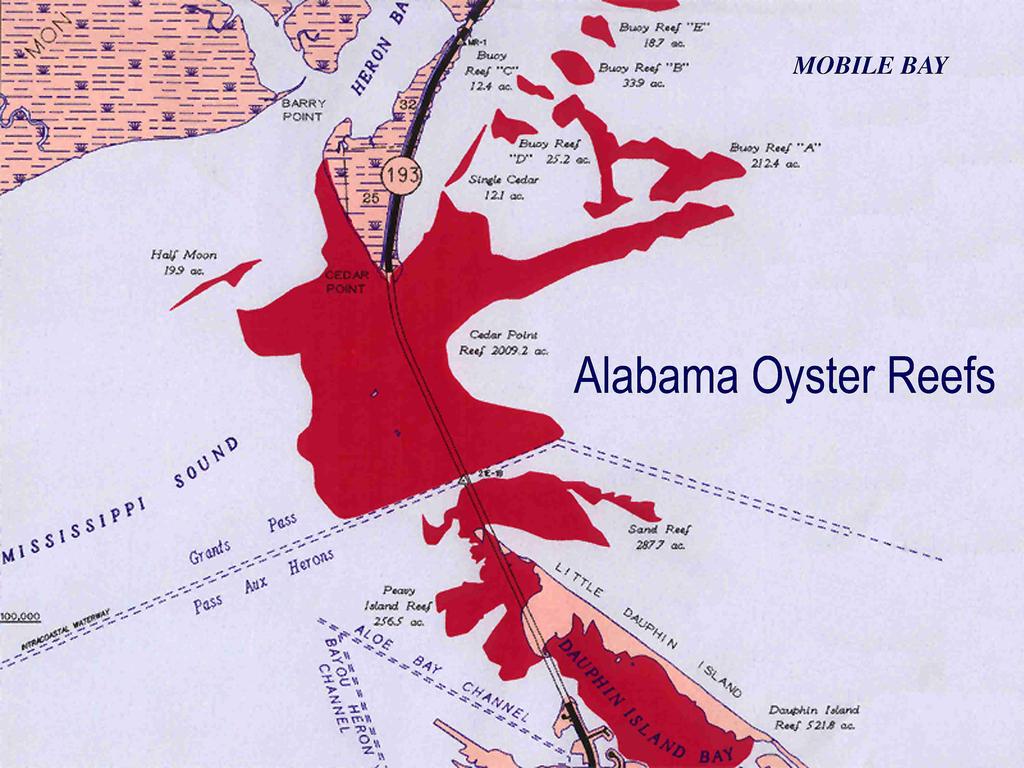
6 The 1995 Atlas of Major Public Oyster Reefs of Alabama and a Review of Oyster Management Efforts Walter M. Tatum, Mark S. Van Hoose, Ralph W. Havard and Mark C. Clark ALABAMA DEPARTMENT OF CONSERVATION AND NATURAL RESOURCES MARINE RESOURCE DIVISION DAUPHIN ISLAND, ALABAMA INTRODUCTION Alabama's oyster reefs have been assessed on six occasions over the last century. Two researchers, Galtsoff (1930) and Engle (1945), confined their efforts to studying the population of oysters and the condition of the reefs. The other studies, Ritter (1896), Moore (1913), Bell (1952) and May (1971), not only studied the condition and population of the reefs but also measured their areas and mapped their configuration. Since the 1968 survey, exploratory drilling for natural gas, production platforms and pipelines, have developed tremendously in the Alabama estuarine area. Such activities involve disruption of bay bottoms in the placement of drilling rigs, pipelines, as well as associated support activities. Concerns arose that the 1968 study was inadequate as a guide to assure placement of rig and pipeline structures in a manner which would have no impact on oyster resources. The 1968 survey, because of the deep draft barges used, gave only a cursory description of the oyster reefs south of the Gulf Intracoastal Waterway (GIWW), Sand Reef and Dauphin Island Bay in particular. Since this area is the subject of natural gas exploration, a new survey was needed of the reefs around Little Dauphin Island to ensure safe placement of rig structures and pipeline corridors. In 1995, funds became available to survey the oyster reefs of Alabama not only south of the GIWW but also those to the north of it. The objective of this survey was to establish the current size and configuration of Alabama's natural oyster reefs in the Dauphin Island- Cedar Point vicinity. Unlike previous works, this survey made no attempt to characterize the population or conditions of the reefs themselves. Since the late 1970's, both fishery dependent and independent data is available to yield a better depiction of Alabama oyster resources than a single overall reef survey. 1 The decade of the 1980's was the period of the most intense shell planting activities in Alabama history. Unfortunately the bulk of federal funding for these activities is tied to natural disasters such as hurricanes and floods and is not available for strictly management purposes. In an effort to establish a stable oyster reef enhancement program, the Alabama Marine Resources Division recommended several new laws designed to benefit Alabama oyster resources in the decade of the 1980's and beyond. These new actions, a sack tagging law, revival of an old law requiring local oyster shops replant shell plus the establishment of annual dive surveys on the reefs and periodic oyster checkpoints has provided the Marine Resources Division with the foundation for annual reef enhancement and management programs based upon yearly population estimates and firm harvest data. Lack of sufficient funding remains a major obstacle by restricting the necessary daily monitoring of oyster harvest and the establishment of annual large reef rehabilitation efforts. PROCEDURE The boundaries of each oyster reef were determined by sounding with a 6-meter pole from a shallow draft boat. Where the edge of the reef was a sand bar, a dredge was towed to determine the presence or absence of oyster spat and cultch material. The location of tows that revealed the presence of little or no reef material was determined to be a point on the edge of the reef. Reefs whose edges were bordered by mud bottoms were not dredged as sounding alone could adequately identify the reef edge. A Si-Tex HE32 recording fathometer was also used to pinpoint the edges of reefs that had high relief profiles. In order to provide a land perspective, the Cedar Point peninsula, Peavy Island, and Little Dauphin Island from its northwest terminus to Pass Drury were surveyed. Once a point on the reef edge was determined, a LORAN C coordinate was recorded. When a sufficient number of points were established to give the size and
7 configuration of the reefs, survey crews from the Engineering Section, Administrative Division, Alabama Department of Conservation and Natural Resources were contacted. They established bench marks on the western shore of Mobile Bay and the high-rise section of the Dauphin Island bridge, Little Dauphin Island and at the Alabama Marine Resources Lab on Dauphin Island. A member of the survey crew, equipped with triple prisms mounted on a rod, was taken to the predetermined loran locations, where the edge of the reef was reconfirmed with a sounding pole, and the survey party chief shot the target using a Wilt T 1600 Total Station Survey Instrument. If the water was choppy or the current strong, a weighted cane pole was placed at the loran location to better hold the boat on station while the survey shot was accomplished. The survey shots were stored in the WILT T instrument memory and downloaded to a PC at Engineering Section headquarters in Montgomery, Alabama. A working map was produced from this information. Shallow water reefs, intertidal reefs and shoreline edges were determined by visual inspection or sounding by cane pole or foot. Aside from the rod man being on foot and not in a boat, survey shots of shallow water and shoreline locations were taken as described previously. RESULTS AND DISCUSSION The present survey was begun in February 1995 and finished in June Coordinating with the state engineers, located in Montgomery, Alabama, to be on site with the proper weather conditions accounted for the extended time needed to accomplish the survey. Actual field time, including initial siting of the points on the reef edges encompassed all or in part of 20 days. The results of the 1995 work and areas surveyed in 1968 are given in Table 1. Results of historical oyster surveys are listed in the appendix. The map of the reefs as delineated in 1995 is contained in the appendix along with the 'XY' survey coordinates used to determine reef edges and the LORAN C coordinates of those edges. In 1968, in order to properly assess population density, May arbitrarily divided Cedar Point reef, a continuous area, into seven sections (Bland personal communication, 1995). He also designated its northwestern most reaches as Heron Bay reefs C and D. May's 1968 Cedar Point A-C, E-H along with Heron 2 Bay D and C are all considered to be Cedar Point reef. in the 1995 survey. In 1995, Sand reef was considered to be the reef area south of the GIWW, east of Little Dauphin Island and north of Peavy Island. In 1968 this area was divided into Sand Reef and Cedar Point D. Peavy Island Reef in 1995 was considered to be the area south of Peavy Island and west of Little Dauphin Island not including the waters of Dauphin Island Bay. All of the oyster reef areas in Dauphin Island Bay proper and its tributaries were designated Dauphin Island Bay Reef in this 1995 survey. The reef area determined in 1995 in the Cedar Point vicinity was nearly twice that found by May in No single explanation can account for the entire difference, however, three major factors are likely responsible. First, between 1968 and 1995, the Mobile Bay area withstood two category three hurricanes. These storms can cover or uncover buried shell. The reefs east of the Dauphin Island bridge that increased in area since 1968 are all located atop extensive buried shell deposits as determined by May (1971), and could have easily had a part of this formerly buried shell exposed by storm tidal scour. A second likely explanation for reef expansion is shell planting. The large amounts of clamshell and oystershell planted from 1970 to 1995 were concentrated west of the Dauphin Island Bridge on Cedar Point reef, especially in the northwest section. Half Moon reef, not shown in the May survey, was the recipient of two shell plantings in the 1980's. These areas increased in size as measured by the 1995 survey. A third explanation for increase in reef area from 1968 to 1995 specifically concerns the shallow water and intertidal reefs south of the GIWW. These reefs, Sand reef, Peavy Island reef, and Dauphin Island Bay reef increased by acres since This probably does not reflect actual reef area growth because in 1968 May (1971) did not have the proper shallow draft equipment to adequately survey these areas (Bland personal communication 1995). The 1995 survey in this area, however, is close to that of Moore (1913). May designated only 8.7 acres of Dauphin Island Bay as oyster reef, while the 1995 survey found acres and Moore listed 756 acres. If the area now dredged to maintain the Dauphin Island Bay channel and Dauphin Island Marina is subtracted from Moore's figure, the result approximates the 1995 total. Similarly, Moore listed 208 acres of productive reef in what is now the Peavy Island reef area. This figures
8 similar to the acres found in 1995 but very different from the 22.2 found by May (1971). Regardless of the specific reasons for the difference in reef areas found by each survey, the configurations for most reefs are basically the same. One exception is Sand reef which has changed radically. The early surveys of Ritter (1896) and Moore (1913) found this area as productive as any in Alabama waters. May (1971) despite his logistic, depth limitations, found the area barren of oysters, but still containing numerous half-shells. The present survey found only hard bottom with little cultch material. In summary, north of the GIWW, Alabama's oyster reefs in the Cedar Point vicinity have changed little in size and configuration in the past 25 years. Much more reef was found south of the GIWW in 1995, but this was largely because this area was inadequately surveyed in MANAGEMENT OF ALABAMA'S OYSTER INDUSTRY Historically Alabama's efforts to manage oyster production and harvest have consisted of planting shell on public reefs. Until the 1970's, oyster shell was used to rehabilitate depleted reefs. Clamshell, because of its availability and cheaper price, had become the preferred cultch from the 1970's through the mid 1980's. In the past decade, oyster shell has again become the predominant cultch material as expense and environmental concerns have eliminated clamshell sources. Table 2 lists recent shell planting efforts. There have been a few efforts over the years to transfer oysters from closed to open areas. In general these small and sporadic attempts have faired poorly because the cost involved in moving the oysters exceeded the subsequent harvest benefits. Current concerns about public health, scarce funding and controversy over moving oysters from traditional, natural areas will severely restrict any future oyster transfer programs. At present Alabama's productive reefs would benefit from extensive shell planting. Lack of suitable cultch is a limiting factor in oyster abundance over large areas of Cedar Point reef. Plantings on the Cedar Point - Heron Bay area in 1990 and 1992 have successfully increased spat set and subsequently oyster harvest. The two major obstacles that large consistent shell 3 planting programs face are 1) supply of shell and 2) financing. Because of the unique nature of Alabama's oyster industry an available supply of oyster shell for cultch is not a problem. Alabama landings have remained at a steady three to four per cent of the overall Gulf totals since the 1960's. However, over that period Alabama has processed nearly 20 % of the oysters landed Gulf wide. These imported oysters provide the shell surplus Alabama enjoys. In the future, however, should other Gulf states process their own oysters, or require that shellstock shipped out of state for processing be returned, Alabama would lose its major source of shell. At that point it would be essential that all oysters harvested from Alabama reefs and subsequent shell received for replanting be documented. Data from periodic enforcement checkpoints in February and April 1995 indicate oystermen caught sacks/day in February and sacks/day in April. Projecting these figures over the entire month, the landings figures should be 28,203 sacks in February and 14,253 sacks in April. The final landings figures for those months as collected by Alabama port agents were 12,804 sacks in February and 9,061 sacks in April, 45% and 64% respectively of the checkpoint landing projections. Lack of funding has prevented the establishment of permanent checkpoint sites, but their need will become critical for the Alabama oyster industry if other Gulf states eventually retain all their respective shellstock. The limiting factor in Alabama shell planting efforts is financing. The large plantings of 1980's were largely funded by federal disaster relief funds in the wake of two hurricanes and a severe flood year. No state or county funds have been available for shell planting with the exception of an occasional special legislative grant. The oyster industry does not allocate any funds for public reef rehabilitation, although the newly revitalized Alabama Seafood Association has plans to supplement Marine Resources Division shell plantings through the cooperation of its membership. A shell planting barge is currently under construction by the Association, with hopes that supplemental shell planting will take place annually beginning in Efforts to address the funding shortfall for shell planting began in the mid 1980's. An oyster sack tagging law provided some funding for shell planting efforts and, helped identify the actual amounts of shell owed by individual shops. Once shell owed by
9 individual shops was determined, collection and planting this shell was initiated. All proceeds from oyster tag sales were used to partially fund these efforts. However, receipts from tag sales were insufficient to completely fund these plantings, thus additional Marine Resources funds were allocated for shell planting purposes. Budget constraints may not allow for Marine Resources Division supplemental funding for future shell plantings. Identification of a stable, consistent source of funds for shell planting is essential if this management practice is to continue. The Marine Resources Division has recently undertaken oyster management projects other than shell planting. An effort to test archeological coral as an alternative cultch material was accomplished. The coral proved successful in capturing spat, however its current cost is far higher than available oyster shell. At present, shell planting efforts by the Marine Resources Division are conducted under a consistent methodology. Under Alabama law each shop owner is required to plant one half of all Alabama shell processed back on the public reefs or pay the Marine Resources Division to do so. In the late winter, when final annual harvest figures are available, a list of each shop and the amounts of shell it owes is provided to the Marine Resources Division biological staff. From the amount of shell owed plus the amount of money available to plant, the quantity of shell to be hauled and planted is determined. The Alabama Department of Finance, Purchasing Division issues an invitation to bid, and contracts to haul, load, and plant shell are awarded. Once these contracts are in place Marine Resources Division biological personnel meet with the representatives of the local oystermen associations and a consensus regarding planting areas is reached. Usually an oysterman will accompany Marine Resources Division personnel to mark the exact sites chosen. Just prior to the beginning of planting the individual shop owners are contacted and offered several options for meeting their shell planting obligations required by law. The choices are, 1) plant half the quantity of Alabama shell they processed at their own expense as required by strict interpretation of the law, 2) if they are situated where their shell can be loaded directly onto a barge, give the Marine Resources Division threequarters of the amount of Alabama oyster shell they processed and Marine Resources Division will pay for planting it or, 3) give the Marine Resources Division all the Alabama shell they processed and Marine 4 Resources Division will haul it to a staging site and plant it from that point. Virtually all shops choose option three. Not only do shops generally choose the third option, many allow and even request that the Marine Resources Division haul all their shell (including imported shell) to the staging area. Thus Marine Resources Division will haul shell until its funding for the activity is exhausted. In 1993 when there was the greatest amount of funding to haul shell ($10,000) Alabama collected cubic yards more shell than was actually processed by Alabama shops. The dollar amount reported for shell hauling and planting does not include Marine Resources Division personnel time, which is significant. To haul shell, one person is required at the shop to issue a receipt for each load to the shop owner, one person at the unloading or staging site to give a receipt to the truck driver, and one person is needed to seek out and identify shops with shell ready to haul that day so the loader can move his equipment from shop to shop in a timely and efficient manner. The shell is loaded from the staging area onto a barge where the person already at the staging area assists an additional man in measuring each barge load. A receipt is given to the loader and the additional man accompanies the barge to the planting site to guide and observe the actual planting operation. The planter is then given a receipt for the amount planted. Finally, the biologist in charge of the entire operation, usually the person who is contacting the shops in advance of shell pickups, must determine the amount of shell hauled and planted at the end of each day, and set priorities as to which shops need to have additional shell collected to fulfill their obligations based upon the updated figures. Each operation, hauling and planting, is usually a hour day. If the salaries and benefits for the biologist, two biologist aides, and laborer who participate in the activity are computed, a day of hauling and planting shell costs the Marine Resources Division $ in personnel expenses. If no equipment breakdown occurs generally 800 yds 3/day can be planted and 1000 yds 3/day can be hauled. Besides shell planting, Alabama Marine Resources Division management efforts concentrate on regulations which provide sack limits and length of the harvest days and season. These regulations are set in meetings with the representatives of local oystermen associations. The sack limit has varied from, no limit, prior to Hurricane Elena in 1985, to 20 sacks/day, in 1987, down to four when the population of oysters on the reef was very low in 1989, upwards to 8 in 1991,
10 to the present 12 set in September The size limit of 75 mm (3 inches) was established in 1937 and the commissioner of conservation given the power to reduce the legal size to 65 mm (2 5/8 inches). In Alabama, oysters can legally be taken only in daylight hours. At present, again with the concurrence of local oyster associations, the harvest hours run from 7 a.m. to 4 p.m. from October to April and 6 a.m. to 12 noon May through September. The change from 6 am. to 7 a.m. is to make allowance for later sunrise in the winter and the one from 4 p.m. to 12 noon to decrease the mortality of spat lying on a hot deck waiting to be culled in the summer. Unless there is a very low population of oysters, requiring reduced harvest pressure, Alabama reefs are closed only by order of the state health department because of high river flows and subsequent increased fecal coliform levels. ACKNOWLEDGMENTS The Alabama Marine Resources Division wishes to express its thanks to the following people who were instrumental in accomplishing this survey. From the Department of Conservation and Natural Resources, Engineering Section, Mike Williford, crew chief, David Temple, instrument operator, Robby Driggers, rod man, Jock Hollings, in charge of field notes and Sam Lanier, cartographer. From the Marine Resources Division, recognition is due to Travis Powell and Johnnie Tharpe for assistance in field work, Steve Heath and Jim Duffy for editorial assistance and Division Director, R. Vernon Minton for securing funding and support for this effort. S. Bur. Fisheries, Rep. of the Comm. of Fisheries for fiscal year 1929, append. 11 (Doc. 1069): May, E. B., A survey of the oyster and oyster shell resources of Alabama. Ala. Mar. Res. Bull. 4:1-53 Moore, H. F Condition and extent of the natural oyster beds and barren bottoms of Mississippi Sound, Alabama Dep. Com. and Labor, Bur. Fisheries Doc. 769: 60 p. Ritter, H. P., Report on a reconnaissance of the oyster beds of Mobile Bay and Mississippi Sound, Alabama. Bull U. S. Fish. Comm. for 1895: Moore, H. F Condition and extent of the natural oyster beds and barren bottoms of Mississippi Sound, Alabama Dep. Com. and Labor, Bur. Fisheries Doc. 769: 60 p. Ritter, H. P., Report on a reconnaissance of the oyster beds of Mobile Bay and Mississippi Sound, Alabama. Bull U. S. Fish. Comm. for 1895: Literature Cited Bell, J. O., A study of oyster production in Alabama waters. M.S.Thesis, Texas A & M College, College Station, TX, 81 p. Bland, D. G., Biologist Aide IV, Alabama Marine ResourcesDivision.Personal Communication. Dauphin Island, Alabama. August Engle, J. B., The condition of the natural oyster reefs and other oyster bottoms of Alabama in 1943 with suggestions for their improvement. U. S. Dep. Interior, Fish Wildlife Services Spec. Sci. Rep. 29: 42 p. Galtsoff, P. S., Destruction of oyster bottoms in Mobile Bay by the flood of U. 5
11 SAND REEF CEDAR POINT REEF X Y GRID COORDINATES OYSTER REEF SURVEY
12 CEDAR PT. REEF cont BUOY REEF A BUOY REEF B BUOY REEF C BUOY REEF D BUOY REEF E KING S BAYOU REEF PEAVY ISLAND REEF DAUPHIN ISLAND REEF
13 DAUPHIN IS. REEF cont MAIN CONTROL POINT FOR 1995 ALABAMA OYSTER REEF SURVEY 21E-1B BRONZE DISK - TOP OF MAIN SPAN DAUPHIN ISLAND BRIDGE
14 LORAN C (GULF CHAIN 7980) PRE-SURVEY CONTROL POINTS SAND REEF W.CEDAR PT. REEF W.CEDAR PT. cont E. CEDAR PT. REEF E. CEDAR PT. cont BUOY REEF A
15 LORAN C (GULF CHAIN 7980) PRE-SURVEY CONTROL POINTS cont. BUOY A cont BUOY REEF B BUOY B cont BUOY REEF C BUOY REEF D BUOY REEF E PEAVY IS. REEF PEAVY IS. cont
16
17 THE 1995 ATLAS OF MAJOR PUBLIC OYSTER REEFS OF ALABAMA AND A REVIEW OF OYSTER MANAGEMENT EFFORTS WALTER M. TATUM MARK S. VAN HOOSE RALPH W. HAVARD MARK C. CLARK
Gulf Research Reports
 Gulf Research Reports Volume 6 Issue 3 January 1979 A Study of Four Oyster Reefs in Mississippi John Ogle Gulf Coast Research Laboratory DOI: 10.18785/grr.0603.06 Follow this and additional works at: http://aquila.usm.edu/gcr
JUNE 2018 RECREATIONAL SHRIMPING REGULATIONS
 K STATE OF ALABAMA DEPARTMENT OF CONSERVATION AND NATURAL RESOURCES MARINE RESOURCES DIVISION POST OFFICE BOX 189 DAUPHIN ISLAND, AL 36528 TEL (251) 861-2882 FAX (251) 861-8741 JUNE 2018 RECREATIONAL SHRIMPING
Use Of Nets And Harvest Of Mullet.
 220-3. 03 Use Of Nets And Harvest Of Mullet. (1) Any person possessing, transporting, or using any seine, gill net, trammel net, or other entangling net more than 300 feet in length as measured along the
August 2018 LIVE BAIT
 STATE OF ALABAMA DEPARTMENT OF CONSERVATION AND NATURAL RESOURCES MARINE RESOURCES DIVISION POST OFFICE BOX 189 DAUPHIN ISLAND, ALABAMA 36528 TEL (251861-2882 FAX (251) 861-8741 August 2018 LIVE BAIT THIS
JUNE 2018 RECREATIONAL SHRIMPING REGULATIONS
 K STATE OF ALABAMA DEPARTMENT OF CONSERVATION AND NATURAL RESOURCES MARINE RESOURCES DIVISION POST OFFICE BOX 189 DAUPHIN ISLAND, AL 36528 TEL (251) 861-2882 FAX (251) 861-8741 JUNE 2018 RECREATIONAL SHRIMPING
APRIL 2017 LIVE BAIT
 K STATE OF ALABAMA DEPARTMENT OF CONSERVATION AND NATURAL RESOURCES MARINE RESOURCES DIVISION POST OFFICE BOX 189 DAUPHIN ISLAND, ALABAMA 36528 TEL (251861-2882 FAX (251) 861-8741 APRIL 2017 LIVE BAIT
APRIL 2017 COMMERCIAL SHRIMPING REGULATIONS
 K STATE OF ALABAMA DEPARTMENT OF CONSERVATION AND NATURAL RESOURCES MARINE RESOURCES DIVISION POST OFFICE BOX 189 DAUPHIN ISLAND, AL 36528 TEL (251) 861-2882 FAX (251) 861-8741 APRIL 2017 COMMERCIAL SHRIMPING
OYSTER REEF RESTORATION; RESTORING ECOLOGICAL FUNCTION
 OYSTER REEF RESTORATION; RESTORING ECOLOGICAL FUNCTION Paul Jensen, David Buzan, and Ka-Leung Lee; Atkins Mark Dumesnil and Julie Sullivan; The Nature Conservancy Presentation Overview The Nature Conservancy
***This summary does not include shad and herring net requirements.***
 South Carolina Department of Natural Resources Marine Resources Division Summary of Seine and Gill Net Laws (Saltwater) 2013-2014 This document should be kept on board all vessels using seines or gill
An Overview of Methods for Estimating Absolute Abundance of Red Snapper in the Gulf of Mexico
 An Overview of Methods for Estimating Absolute Abundance of Red Snapper in the Gulf of Mexico JM Drymon 1, Greg Stunz 2 1. Mississippi State University, Coastal Research and Extension Center 2. Harte Research
OCTOBER 2018 COMMERCIAL SHRIMPING REGULATIONS
 STATE OF ALABAMA DEPARTMENT OF CONSERVATION AND NATURAL RESOURCES MARINE RESOURCES DIVISION POST OFFICE BOX 189 DAUPHIN ISLAND, AL 36528 TEL (251) 861-2882 FAX (251) 861-8741 OCTOBER 2018 COMMERCIAL SHRIMPING
INFORMATIONAL SERIES No. 2. THE SHRIMP FISHERY OF THE GULF OF MEXICO (Rio Grande River to St. Marks, Florida) BIOLOGICAL NOTES AND RECOMMENDATIONS
 BIOLOGICAL NOTES AND RECOMMENDATIONS") OFFICE COPY ONLY Qiulf j-fates )mtarine ]Jrisqeries
OFFICE COPY ONLY Qiulf j-fates )mtarine ]Jrisqeries
1-32 NOME HARBOR, ALASKA (CWIS NOS , 87755, & 10422) Condition of Improvement 30 September 2009
 Condition of Improvement 30 September 2009") NOME HARBOR 1-32 NOME HARBOR, ALASKA (CWIS NOS. 72742, 87755, & 10422) Condition of Improvement 30 September 2009 AUTHORIZATION: (1) Rivers and Harbors Act, 8 August 1917 (House Doc. 1932, 64th Congress,
NOME HARBOR 1-32 NOME HARBOR, ALASKA (CWIS NOS. 72742, 87755, & 10422) Condition of Improvement 30 September 2009 AUTHORIZATION: (1) Rivers and Harbors Act, 8 August 1917 (House Doc. 1932, 64th Congress,
SOCIETAL GOALS TO DETERMINE ECOSYSTEM HEALTH: A FISHERIES CASE STUDY IN GALVESTON BAY SYSTEM, TEXAS
 SOCIETAL GOALS TO DETERMINE ECOSYSTEM HEALTH: A FISHERIES CASE STUDY IN GALVESTON BAY SYSTEM, TEXAS Anthony S. Pait, NOAA, National Centers for Coastal Ocean Science Thomas P. O Connor, David R. Whitall,
Charter Boat Fishing in Lake Michigan: 2017 Illinois Reported Harvest
 Illinois Department of Natural Resources Division of Fisheries Charter Boat Fishing in Lake Michigan: 2017 Illinois Reported Harvest Steven R. Robillard Illinois Department of Natural Resources Lake Michigan
1-32 NOME HARBOR, ALASKA (CWIS NOS , 87755, 12270, & 10422) Condition of Improvement 30 September 2012
 Condition of Improvement 30 September 2012") NOME HARBOR 1-32 NOME HARBOR, ALASKA (CWIS NOS. 72742, 87755, 12270, & 10422) Condition of Improvement 30 September 2012 AUTHORIZATION: (1) Rivers and Harbors Act, 8 August 1917 (House Doc. 1932, 64th
NOME HARBOR 1-32 NOME HARBOR, ALASKA (CWIS NOS. 72742, 87755, 12270, & 10422) Condition of Improvement 30 September 2012 AUTHORIZATION: (1) Rivers and Harbors Act, 8 August 1917 (House Doc. 1932, 64th
The Blue Heron Slough Conservation Bank
 1 The Blue Heron Slough Conservation Bank CONSERVATION BANKING July 19-23, 2010 CASE STUDY SERIES The Blue Heron Slough Conservation Bank (Washington) I. OVERVIEW & BACKGROUND: Location: Snohomish River
Hydrographic Surveying Methods, Applications and Uses
 Definition: Hydrographic Surveying Methods, Applications and Uses It is the branch of surveying which deals with any body of still or running water such as a lake, harbor, stream or river. Hydrographic
BAYKEEPER. Utilizing Volunteers in Baykeeper s Oyster Restoration Program
 NY/NJ BAYKEEPER Utilizing Volunteers in Baykeeper s Oyster Restoration Program Meredith Comi, Oyster Restoration Program Director Hooked on our Waters October 19, 2013 Baykeeper s Mission PROTECT, PRESERVE,
Cook Inlet pipeline crossing is about making the best choices
 Cook Inlet pipeline crossing is about making the best choices By Larry Persily lpersily@kpb.us Aug. 26, 2015 (This update, provided by the Kenai Peninsula Borough mayor s office, is part of an ongoing
THE OYSTER RESOURCE IN NORTH CAROLINA
 THE OYSTER RESOURCE IN NORTH CAROLINA NC DIVISION OF MARINE FISHERIES November 2010 History of Oysters in North Carolina Wide distribution of shell middens indicates utilization by Native Americans Early
JOB REPORT. R.P. Hofstetter Marine Biologist. Survey of the Abundance and Condition of Market Oysters
 JOB REPORT R.P. Hofstetter Marine Biologist Project No. M01R1 Date; August, 1959 Project Names Oyster Investigation, Galveston Bay Period Covered* January, 19 8 Jane, 1959» Job No. B3 Survey of the Abundance
Living Shorelines. Created by: JoAnn Moody & Tina Miller-Way Discovery Hall Programs Dauphin Island Sea Lab
 Living Shorelines Created by: JoAnn Moody & Tina Miller-Way Discovery Hall Programs Dauphin Island Sea Lab Living Shorelines Subject: Life Science Grade Level: 6 th -8 th Time Required: 60 min Key Terms:
INLAND LAKE MANAGEMENT REPORT FY Spring 2008
 INLAND LAKE MANAGEMENT REPORT FY 2008 Spring 2008 Prepared by Robert O. Andress District Fisheries Biologist E. Daniel Catchings District Fisheries Supervisor Kevin W. Baswell District Biologist Aide Department
 Page 1 of 6 Nav-Aid Basics Unlike the roads and highways that we drive on, the waterways we go boating on do not have road signs that tell us our location, the route or distance to a destination, or of
Dauphin Lake Fishery. Status of Walleye Stocks and Conservation Measures
 Dauphin Lake Fishery Status of Walleye Stocks and Conservation Measures Date: December, 21 Dauphin Lake Fishery Status of Walleye Stocks and Conservation Measures Background: Walleye stocks in Dauphin
Coastal Wetlands Protection Act. Fisheries Management, Marine Sanctuaries and Closures
 , STATE AND LOCAL AUTHORITY FOR MARINE PROTECTION (2014). MISSISSIPPI 1 State Authority for Protection Summary of State Authorities Mississippi has several options for conserving marine habitat; however,
April 7, Prepared for: The Caribbean Disaster Emergency Response Agency Prepared by: CEAC Solutions Co. Ltd.
 April 7, 2006 Prepared for: The Caribbean Disaster Emergency Response Agency Prepared by: Introduction CEAC Solutions Co. Ltd was commissioned in May 2005 to prepare coastal beach erosion hazard maps for
Report on a Salmon Survey in the Waterford Estuary in 2010
 Report on a Salmon Survey in the Waterford Estuary in 2010 Dr. P. Gargan Inland Fisheries Ireland June 2011 1 Contents 1. Introduction 3 2. Proposal for a Survey in Waterford estuary in 2010 3 3. Survey
Video-Based Mapping of Oyster Bottom in the Upper Piscataqua River, Sturgeon Creek, and Spruce Creek
 University of New Hampshire University of New Hampshire Scholars' Repository PREP Reports & Publications Institute for the Study of Earth, Oceans, and Space (EOS) 1-21-2009 Video-Based Mapping of Oyster
ST. LOUIS SECTION PROJECT OF THE YEAR AWARD
 ST. LOUIS SECTION PROJECT OF THE YEAR AWARD Originality and Innovation The St. Louis Harbor Project is located in the Upper Mississippi River between the entrance to the Chain of Rocks Canal at River
AUTOMATIC DREDGING PROFILE AND CONTOUR CONTROL
 AUTOMATIC DREDGING PROFILE AND CONTOUR CONTROL Jay Wise 1 ABSTRACT Phillips and Jordan, a leading excavating and disaster recovery contractor, was faced with the challenge to manage a civil contract involving
Susquehanna River Walleye Fishery
 Susquehanna River Walleye Fishery 2008 The Susquehanna River is the largest tributary to the Atlantic Ocean lying completely within the United States. It originates from the outlet of Otsego Lake in Cooperstown,
Delineation of the Asian Clam (Corbicula fluminea) Population at Sand Harbor State Park, Nevada
 Population at Sand Harbor State Park, Nevada") Delineation of the Asian Clam (Corbicula fluminea) Population at Sand Harbor State Park, Nevada Report to the Nevada Division of State Lands and the Tahoe Regional Planning Agency Final Draft Brant Allen,
Delineation of the Asian Clam (Corbicula fluminea) Population at Sand Harbor State Park, Nevada Report to the Nevada Division of State Lands and the Tahoe Regional Planning Agency Final Draft Brant Allen,
Striped Bass and White Hybrid (x) Striped Bass Management and Fishing in Pennsylvania
 Striped Bass Management and Fishing in Pennsylvania") Striped Bass and White Hybrid (x) Striped Bass Management and Fishing in Pennsylvania Prepared by R. Lorantas, D. Kristine and C. Hobbs PFBC Warmwater Unit 2005 (stocking numbers updated after 2005) Goal:
Striped Bass and White Hybrid (x) Striped Bass Management and Fishing in Pennsylvania Prepared by R. Lorantas, D. Kristine and C. Hobbs PFBC Warmwater Unit 2005 (stocking numbers updated after 2005) Goal:
Engineering Surveying - II CE313. Hydrographic Survey Lecture 06 Muhammad Noman
 Engineering Surveying - II CE313 Hydrographic Survey Lecture 06 Muhammad Noman Hydrographic Surveying Hydrographic surveying is the branch of the survey which deal with any body of still or running water
Admiralty Inlet Pilot Tidal Project FERC No Appendix C. Derelict Gear Monitoring Plan
 Appendix C Derelict Gear Monitoring Plan ADMIRALTY INLET PILOT TIDAL PROJECT FERC PROJECT NO. 12690 DERELICT GEAR MONITORING PLAN (submitted with the Final Application for a New Pilot Project License)
Near-Field Sturgeon Monitoring for the New NY Bridge at Tappan Zee. Quarterly Report July 1 September 30, 2014
 Near-Field Sturgeon Monitoring for the New NY Bridge at Tappan Zee Quarterly Report July 1 September 30, 2014 Prepared by AKRF, Inc. 7250 Parkway Drive, Suite 210 Hanover, MD 21076 for New York State Thruway
Agenda Item Summary BACKGROUND. Attachment 1
 Agenda Item Summary Attachment 1 BACKGROUND Oregon s recreational abalone fishery was suspended by emergency rule beginning January 1, 2018. This suspension was due to 1) low densities of red abalone,
UPPER BEACH REPLENISHMENT PROJECT RELATED
 ASSESSMENT OF SAND VOLUME LOSS at the TOWNSHIP of UPPER BEACH REPLENISHMENT PROJECT RELATED to the LANDFALL OF HURRICANE SANDY - PURSUANT TO NJ-DR 4086 This assessment is in response to Hurricane Sandy
Charter Boat Fishing in Lake Michigan: 2015 Illinois Reported Harvest
 Illinois Department of Natural Resources Division of Fisheries Charter Boat Fishing in Lake Michigan: 2015 Illinois Reported Harvest Steven R. Robillard Illinois Department of Natural Resources Lake Michigan
Florida Seagrass Integrated Mapping and Monitoring Program
 Florida Seagrass Integrated Mapping and Monitoring Program - 2004 The following document is composed of excerpts taken from the 2011 publication, Seagrass Integrated Mapping and Monitoring for the State
Recommended Fish Handling Guidelines for Bass Tournaments in Alabama Waters
 Recommended Fish Handling Guidelines for Bass Tournaments in Alabama Waters Damon Lee Abernethy Fisheries Development Coordinator and Brian Rinehard Fish Hatchery Coordinator Alabama Department of Conservation
NEVADA DEPARTMENT OF WILDLIFE STATEWIDE FISHERIES MANAGEMENT
 NEVADA DEPARTMENT OF WILDLIFE STATEWIDE FISHERIES MANAGEMENT FEDERAL AID JOB PROGRESS REPORTS F-20-52 2016 Lake Tahoe Rainbow Trout Study WESTERN REGION NEVADA DEPARTMENT OF WILDLIFE, FISHERIES DIVISION
NEVADA DEPARTMENT OF WILDLIFE STATEWIDE FISHERIES MANAGEMENT
 NEVADA DEPARTMENT OF WILDLIFE STATEWIDE FISHERIES MANAGEMENT FEDERAL AID JOB PROGRESS REPORTS F-20-52 2016 BOULDER RESERVOIR WESTERN REGION NEVADA DEPARTMENT OF WILDLIFE, FISHERIES DIVISION ANNUAL PROGRESS
Public Notice U.S. Army Corps In Reply to Application Number CENAB-OP-RMS (NATIONAL HARBOR (FORMERLY PORT Baltimore District AMERICA])
![Public Notice U.S. Army Corps In Reply to Application Number CENAB-OP-RMS (NATIONAL HARBOR (FORMERLY PORT Baltimore District AMERICA])](/thumbs/89/100795623.jpg "Public Notice U.S. Army Corps In Reply to Application Number CENAB-OP-RMS (NATIONAL HARBOR (FORMERLY PORT Baltimore District AMERICA])") Public Notice U.S. Army Corps In Reply to Application Number of Engineers CENAB-OP-RMS (NATIONAL HARBOR (FORMERLY PORT Baltimore District AMERICA]) 88-01361 PN 14-05 Comment Period: January 16, 2014 to
Public Notice U.S. Army Corps In Reply to Application Number of Engineers CENAB-OP-RMS (NATIONAL HARBOR (FORMERLY PORT Baltimore District AMERICA]) 88-01361 PN 14-05 Comment Period: January 16, 2014 to
Ketchikan Harbors Thomas Basin and Bar Point Harbor
 Ketchikan Harbors Thomas Basin and Bar Point Harbor Condition of Improvements 30 December 2014 Thomas Basin & Bar Point Harbors Ketchikan, Alaska (CWIS No. 000631 & 087071) Authorization (1) Rivers and
MS/AL Living Shoreline Workshop
 Daniel Wachenfeld / Triggerfish Images MS/AL Living Shoreline Workshop 2010 Jeff DeQuattro jdequattro@tnc.org March 17, Living Shoreline Restoration Graphic Credit: Mobile Press Register Living Shoreline
FACT SHEET MCGREGOR LAKE RESTORATION HABITAT PROJECT POOL 10, UPPER MISSISSIPPI RIVER, WISCONSIN ENVIRONMENTAL MANAGEMENT PROGRAM
 FACT SHEET MCGREGOR LAKE RESTORATION HABITAT PROJECT POOL 10, UPPER MISSISSIPPI RIVER, WISCONSIN ENVIRONMENTAL MANAGEMENT PROGRAM LOCATION McGregor Lake is located within a mid-river island in Pool 10
Biological Review of the 2014 Texas Closure
 Biological Review of the 2014 Texas Closure Report to the Gulf of Mexico Fishery Management Council by James M. Nance, Ph.D. Southeast Fisheries Science Center Galveston Laboratory January 2015 Introduction
UTAH RECLAMATION MITIGATION AND CONSERVATION COMMISSION [RC0ZCUPCA0, 155R0680R1, RR ]
![UTAH RECLAMATION MITIGATION AND CONSERVATION COMMISSION [RC0ZCUPCA0, 155R0680R1, RR ]](/thumbs/86/94483046.jpg "UTAH RECLAMATION MITIGATION AND CONSERVATION COMMISSION [RC0ZCUPCA0, 155R0680R1, RR ]") This document is scheduled to be published in the Federal Register on 07/07/2015 and available online at http://federalregister.gov/a/2015-16600, and on FDsys.gov DEPARTMENT OF THE INTERIOR UTAH RECLAMATION
This document is scheduled to be published in the Federal Register on 07/07/2015 and available online at http://federalregister.gov/a/2015-16600, and on FDsys.gov DEPARTMENT OF THE INTERIOR UTAH RECLAMATION
EVALUATION OF BEACH EROSION UP-DRIFT OF TIDAL INLETS IN SOUTHWEST AND CENTRAL FLORIDA, USA. Mohamed A. Dabees 1 and Brett D.
 EVALUATION OF BEACH EROSION UP-DRIFT OF TIDAL INLETS IN SOUTHWEST AND CENTRAL FLORIDA, USA Mohamed A. Dabees 1 and Brett D. Moore 1 The paper discusses the analysis of up-drift beach erosion near selected
Rising Tide Oyster Company 2.0 Acre Bellamy Site Marine Aquaculture License Application
 Rising Tide Oyster Company 2.0 Acre Bellamy Site Marine Aquaculture License Application Joshua and Jessica Carloni 264 Swain Road Barrington, N.H. 03825 Summary This is an amendment to our existing license
Estuarine Shoreline Stabilization
 Estuarine Shoreline Stabilization Property Owner s Guide to Determining the Most Appropriate Stabilization Method Estuarine shorelines are dynamic features that experience continued erosion. Land is lost
High Definition Laser Scanning (HDS) Underwater Acoustic Imaging and Profiling
 Underwater Acoustic Imaging and Profiling") High Definition Laser Scanning (HDS) Underwater Acoustic Imaging and Profiling Images at Depth: The Use of Acoustic Imaging on Large River Crossings A Case Study AGENDA Background of project Review of
High Definition Laser Scanning (HDS) Underwater Acoustic Imaging and Profiling Images at Depth: The Use of Acoustic Imaging on Large River Crossings A Case Study AGENDA Background of project Review of
TABLE ROCK LAKE 2014 ANNUAL LAKE REPORT. Shane Bush Fisheries Management Biologist Missouri Department of Conservation Southwest Region
 TABLE ROCK LAKE 14 ANNUAL LAKE REPORT Shane Bush Fisheries Management Biologist Missouri Department of Conservation Southwest Region March 1, 15 EXECUTIVE SUMMARY Table Rock Lake is a 43,1 acre reservoir
CNY Bass Anglers Tournament Rules Adopted July 2011
 CNY Bass Anglers Tournament Rules Adopted July 2011 1. RULE CHANGES: a. The rules set forth herein are to apply to all club tournaments. The interpretation shall lie solely with the tournament director
ARTIFICIAL REEF CONSTRUCTION: AN ENGINEERED APPROACH. Timothy K. Blankenship, P.E. R. Harvey Sasso, P.E.
 ARTIFICIAL REEF CONSTRUCTION: AN ENGINEERED APPROACH Timothy K. Blankenship, P.E. R. Harvey Sasso, P.E. Coastal Systems International, Inc. 464 South Dixie Highway Coral Gables, Florida 33146 Stephen Higgins
NURSERY POND Fish Management Report. Jason C. Doll Assistant Fisheries Biologist
 NURSERY POND 2004 Fish Management Report Jason C. Doll Assistant Fisheries Biologist FISHERIES SECTION INDIANA DEPARTMENT OF NATURAL RESOURCES DIVISION OF FISH AND WILDLIFE I.G.C. South, Room W273 402
Loughs Agency. Foyle, Carlingford and Irish Lights Commission. Pre-Fishery Stock Assessment Lough Foyle Native Oyster Fishery.
 Loughs Agency Foyle, Carlingford and Irish Lights Commission Pre-Fishery Stock Assessment Lough Foyle Native Oyster Fishery Summary Report Autumn 216 1 Aquaculture & Shellfisheries Report Reference LA/Y/216
CHAPTER 6 10/29/2018 Clean Version REGULATING PIERS, WHARVES, MOORING BUOYS, SWIMMING RAFTS AND INFLATABLES ON ROCK LAKE
 1 2 3 4 5 6 7 8 9 10 11 12 13 14 15 16 17 18 19 20 21 22 23 24 25 26 27 28 29 30 31 32 33 34 35 36 37 38 39 40 41 42 43 44 45 46 CHAPTER 6 10/29/2018 Clean Version REGULATING PIERS, WHARVES, MOORING BUOYS,
New Millennium Dive Expeditions
 New Millennium Dive Expeditions 15030 N Timberline Drive Reno, NV 89511 (775)850-2510 * nmde@att.net www.nmde.org Project Report July 12, 2013: Phase 1 of 2 (Phase 2: August 26 th 30 th, 2013) Supporting
Texas Department of Transportation s Gulf Intracoastal Waterway Capacity Study. GICA 112 th Annual Seminar July 28, 2017
 Texas Department of Transportation s Gulf Intracoastal Waterway Capacity Study GICA 112 th Annual Seminar July 28, 2017 Study Purpose Determine if current levels of vessel activity on the Texas segment
THE WILDLIFE CONSERVATION AND MANAGEMENT ACT. (No. 47 of 2013)
") THE WILDLIFE CONSERVATION AND MANAGEMENT ACT (No. 47 of 2013) IN EXERCISE of the powers conferred by section 109(4) (b) of the Wildlife Conservation and Management Act, 2013, the Cabinet Secretary for
THE WILDLIFE CONSERVATION AND MANAGEMENT ACT (No. 47 of 2013) IN EXERCISE of the powers conferred by section 109(4) (b) of the Wildlife Conservation and Management Act, 2013, the Cabinet Secretary for
ATTACHMENT F. Minnesota Department of Natural Resources. Marsh Lake Ecosystem Restoration Project
 ATTACHMENT F Minnesota Department of Natural Resources Marsh Lake Ecosystem Restoration Project Mussel Rescue and Translocation Plan for Pomme de Terre River Restoration (Prepared June, 2016) Attachment
ROCKWALL CENTRAL APPRAISAL DISTRICT
 ROCKWALL CENTRAL APPRAISAL DISTRICT WILDLIFE MANAGEMENT SPECIAL VALUATION GUIDELINES A SUPPLEMENT TO THE STATE OF TEXAS GUIDELINES FOR QUALIFICATION OF AG LAND IN WILDLIFE MANAGEMENT USE These guidelines
Upper/Lower Owl Creek Reservoir
 Upper/Lower Owl Creek Reservoir Schuylkill County 2018 Largemouth Bass Survey Upper Owl Creek Reservoir and Lower Owl Creek Reservoir are 67-acre and 26-acre impoundments, respectively, created by two
Hurricane IVAN Lessons Learned Energy Loss Adjusters Perspective. Bryan C. Johnson
 Hurricane IVAN Lessons Learned Energy Loss Adjusters Perspective Bryan C. Johnson I. Lessons Learned - Adjustment Process II. Lessons Learned - The Storm Lessons Learned - Adjustment Process Issues Regarding
Nome Harbor Page 2 of 12
 Nome Harbor Nome Harbor Page 2 of 12 Condition of Improvements 30 December 2015 Nome Harbor, Alaska (CWIS No. 010422, 012270, 072742, 087755) Authorization (1) Rivers and Harbors Act, 8 August 1917 (House
Planning Considerations for Nearshore Placement of Mixed Dredged Sediments
 Planning Considerations for Nearshore Placement of Mixed Dredged Sediments PURPOSE: Dredging planning and management decisions are based on a combination of engineering and economic factors tempered by
MARSH DEGRADATION AT THE MOUTH OF MOORE CREEK
 MARSH DEGRADATION AT THE MOUTH OF MOORE CREEK Hunter Winstanley, Department of Earth Sciences, University of South Alabama, Mobile, AL 36688. E-Mail: hcw501@jaguar1.usouthal.edu. Moore Creek is located
MEMORANDUM Comfort Lake-Forest Lake Watershed District
 MEMORANDUM Comfort Lake-Forest Lake Watershed District To: Board of Managers Date: December 7, 2016 From: Mike Kinney Subject: 2016 Watercraft Inspections and AIS Report Summaries Watercraft Inspection
Minnesota Deer Population Goals
 Minnesota Deer Population Goals Superior Uplands Arrowhead Goal Block Minnesota DNR Section of Wildlife, 2015 Final Deer Population Goals Block 1: Superior Uplands Arrowhead The following pages provide
OFFICE OF STRUCTURES MANUAL FOR HYDROLOGIC AND HYDRAULIC DESIGN CHAPTER 11 APPENDIX B TIDEROUT 2 USERS MANUAL
 OFFICE OF STRUCTURES MANUAL FOR HYDROLOGIC AND HYDRAULIC DESIGN CHAPTER 11 APPENDIX B TIDEROUT 2 USERS MANUAL APRIL 2011 APRIL 2011 Page 1 Preface TIDEROUT 2, Build 1.22 dated June 29, 2006 is the current
Ninilchik Harbor Page 2 of 11
 Ninilchik Harbor Ninilchik Harbor Page 2 of 11 Condition of Improvements 31 December 2017 Ninilchik Harbor, Alaska (CWIS No. 012640, 087345) Authorization Rivers and Harbors Act, 3 July 1958 (P.L. 85-500
17-06 BFT RECOMMENDATION BY ICCAT FOR AN INTERIM CONSERVATION AND MANAGEMENT PLAN FOR WESTERN ATLANTIC BLUEFIN TUNA
 17-06 BFT RECOMMENDATION BY ICCAT FOR AN INTERIM CONSERVATION AND MANAGEMENT PLAN FOR WESTERN ATLANTIC BLUEFIN TUNA RECALLING the Recommendation by ICCAT to Establish a Rebuilding Program for Western Atlantic
Cordova Harbor Page 2 of 9
 Cordova Harbor Cordova Harbor Page 2 of 9 Condition of Improvements 30 December 2017 Cordova Harbor, Alaska (CWIS No. 087136, 087186, 087711) Authorization Rivers and Harbors Act, 30 August 1935 (R & H
Nicholas Brown. 31 Bennett Rd Wolfeboro NH Application submitted
 Nicholas Brown 31 Bennett Rd Wolfeboro NH 03894 603-856-5454 Nick4634@gmail.com Application submitted 8-12-2017 Description of proposed project A. General Methodology The site located approximately 600
Chesapeake Bay Jurisdictions White Paper on Draft Addendum IV for the Striped Bass Fishery Management Plan
 Chesapeake Bay Jurisdictions White Paper on Draft Addendum IV for the Striped Bass Fishery Management Plan Maryland Department of Natural Resources, District of Columbia s Fisheries and Wildlife Division,
Instruction Guide for using Dive Tables (draft)
") Instruction Guide for using Dive Tables (draft) Revision 1.0 US Navy Tables Rev 6 December 2009 Landis Bullock This guide is intended to supplement the instruction of a qualified SCUBA Instructor, not
Instruction Guide for using Dive Tables (draft) Revision 1.0 US Navy Tables Rev 6 December 2009 Landis Bullock This guide is intended to supplement the instruction of a qualified SCUBA Instructor, not
New two-lane bridge to replace the existing structure spanning the Maple River just south of the Village s central business district
 New two-lane bridge to replace the existing structure spanning the Maple River just south of the Village s central business district Rehabilitate the old bridge Convert to a nonmotorized trail Restore
Environment and Natural Resources Trust Fund (ENRTF) M.L LCCMR Work Plan
 M.L LCCMR Work Plan") Environment and Natural Resources Trust Fund (ENRTF) M.L. 2017 LCCMR Work Plan Date of Submission: May 31, 2017 Date of Next Status Update Report: January 1, 2018 Date of Work Plan Approval: 06/07/2017
Environment and Natural Resources Trust Fund (ENRTF) M.L. 2017 LCCMR Work Plan Date of Submission: May 31, 2017 Date of Next Status Update Report: January 1, 2018 Date of Work Plan Approval: 06/07/2017
Juneau Douglas Harbor
 Juneau Douglas Harbor Douglas Harbor Page 2 of 8 Condition of Improvements 31 December 2015 Douglas Harbor, Alaska (CWIS No. 072789, 180942) Authorization Rivers and Harbors Act, 3 July 1958 (House Doc.
Holman Char Fishing Plan
 Holman Char Fishing Plan 2001-2004 Fisheries and Oceans Canada Northwest Territories Fishery Regulations that apply to subsistence fisheries for Holman area char: 1) Nets must be checked every 30 hours
Maltester Channel Dredging. Shoreline Marina Committee. November 18, 2008
 Maltester Channel Dredging Shoreline Marina Committee November 18, 2008 Shoaling Study Summary Report Completed in October 2008 Analyzed siltation rates at Marina Rate of siltation is dynamic ranging from
LOGAN MARTIN RESERVOIR MANAGEMENT REPORT. Prepared by. E. Daniel Catchings District Fisheries Supervisor
 LOGAN MARTIN RESERVOIR MANAGEMENT REPORT 2008 Prepared by E. Daniel Catchings District Fisheries Supervisor Robert O. Andress District Fisheries Biologist Department of Conservation and Natural Resources
Assateague Island National Seashore North End Restoration Project Timeline
 Assateague Island National Seashore North End Restoration Project Timeline Date Event Some information provided in the Project Introduction document. Detailed events are available in a timeline compiled
SARASOTA BAY ESTUARY PROGRAM OYSTER HABITAT MONITORING RESULTS: YEAR 1. Jay R. Leverone
 SARASOTA BAY ESTUARY PROGRAM OYSTER HABITAT MONITORING RESULTS: YEAR 1 by Jay R. Leverone Mote Marine Laboratory 1600 Ken Thompson Parkway Sarasota, Fl 34236 to Gary Raulerson Sarasota Bay Estuary Program
REQUEST FOR BIDS For Intake Tunnel Project Bid Notice
 REQUEST FOR BIDS For Intake Tunnel Project 2018 Bid Notice Bell County Water Control & Improvement District No. 1 (District) is soliciting Request for Bids for the videoing and cleaning, replacing trash
Issues facing this region include the status of the Sluice Creek tide gates, various tidal wetlands, and locations of public access:
 5.6 Guilford Point to Madison Town Line Existing Resources This region extends from Guilford Point to the Madison town line. Named places include Grass Island and the East River. Residential, commercial,
Minnesota Department of Natural Resources Fisheries Division, Lake Superior Area
 Minnesota F-9-R(P)- Study 4 Job 616 Minnesota Department of Natural Resources Fisheries Division, Lake Superior Area Coaster Brook Trout Status in Minnesota-Lake Superior Tributaries Following Regulation
Certified Professionals in Hydrographic Solutions
 Certified Professionals in Hydrographic Solutions Client Satisfaction is our Deliverable Port of Brisbane Pty Ltd Port Surveys Certified Professionals in Hydrographic Surveying Tel +61 (0) 7 3258 4820
Figure79. Location map for the 10 NJBPN profile sites in Atlantic County, NJ 155
 154 Figure79. Location map for the 10 NJBPN profile sites in Atlantic County, NJ 155 ATLANTIC COUNTY SPRING 2009 to FALL 2010 The Atlantic County coastline consists of three barrier islands. Between Little
Unassessed Waters Initiative ( )
") Unassessed Waters Initiative (2010-2015) Robert Weber Fisheries Biologist PA Fish and Boat Commission Division of Fisheries Management Aiden Simpson Fisheries Biologist Western Pennsylvania Conservancy
Unassessed Waters Initiative (2010-2015) Robert Weber Fisheries Biologist PA Fish and Boat Commission Division of Fisheries Management Aiden Simpson Fisheries Biologist Western Pennsylvania Conservancy
NEVADA DEPARTMENT OF WILDLIFE STATEWIDE FISHERIES MANAGEMENT
 NEVADA DEPARTMENT OF WILDLIFE STATEWIDE FISHERIES MANAGEMENT FEDERAL AID JOB PROGRESS REPORTS F-20-52 2016 LAKE TAHOE WESTERN REGION NEVADA DEPARTMENT OF WILDLIFE, FISHERIES DIVISION ANNUAL PROGRESS REPORT
Rock Creek Huntington County Supplemental Evaluation
 Rock Creek Huntington County Supplemental Evaluation Date of Survey: September 8 to September 10, 2008 Biologist: Rod A. Edgell Survey Objectives: Conduct population estimates for game fish at Rock Creek
Evaluation of Placement Alternatives for Matagorda Ship Channel Bottleneck Removal
 Evaluation of Placement Alternatives for Matagorda Ship Channel Bottleneck Removal James Rosati III Ashley E. Frey CPT Grays Harbor, WA Wood Wood chips Flour Other CMS Shark River Inlet, NJ US Army Corps
Chapter 20. Sampling the Recreational Creel
 Chapter 20 Sampling the Recreational Creel 20.1 Introduction - Creel Surveys Management requires information Environment in which fish lives Management requires information (cont.) *Other organisms with
Conservation and Natural Resources Chapter ALABAMA DEPARTMENT OF CONSERVATION AND NATURAL RESOURCES ADMINISTRATIVE CODE
 ALABAMA DEPARTMENT OF CONSERVATION AND NATURAL RESOURCES ADMINISTRATIVE CODE CHAPTER 220-3 MARINE RESOURCES DIVISION TABLE OF CONTENTS 220-3-.01 Shrimping 220-3-.02 Oystering 220-3-.03 Use Of Nets And
Florida stone crab, Menippe mercenaria, and gulf stone crab, M. adina
 Florida stone crab, Menippe mercenaria, and gulf stone crab, M. adina Stone crabs are found from North Carolina south around peninsular Florida to the Yucatan Peninsula and Belize and throughout the Bahamas