Harvey Dam. Dam Wall P CP. Lookout. Spillway. Intake Tower. Harvey River. Viewing Area. Key Buildings Stage Amphitheatre Gazebo
|
|
|
- Shona Wilkerson
- 5 years ago
- Views:
Transcription

1 Harvey Dam


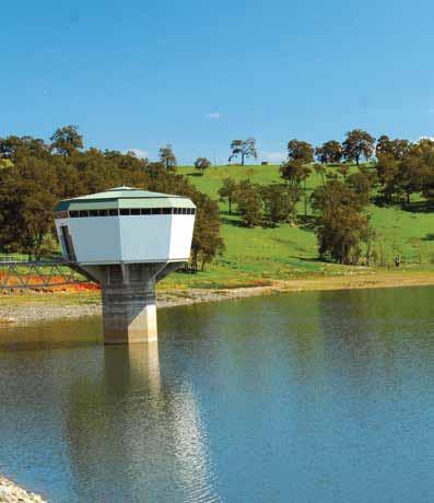
2 Access Rd N Lookout Spillway Intake Tower Harvey Quindanning Road Harvey River C Dam Wall Viewing Area Harvey Dam m Key Buildings Stage Amphitheatre Gazebo C Gas Barbecue layground arking Coach ark Toilets icnic Area Walkway Road No dogs permitted

3 History of Harvey Dam The original Harvey Weir was part of the first irrigation scheme in Western Australia, and only the sixth public dam developed in the state. Construction of the Harvey Weir began in 1914 and took two years to complete with over 100 men employed using horse and dray for the excavation works. The Weir had a 12m high concrete wall and held 512 million gallons of water. In 1931, the dam wall was raised to 18 metres, increasing the storage capacity to 2,275 million gallons. With increasing population and economic growth during the 1990s plans were made to build a new dam, six times the capacity of the Harvey Weir. The new Harvey Dam was completed in 2002 as part of the $275 million Stirling-Harvey Redevelopment Scheme. rotecting the dam for future generations Remember that water catchments are natural conservation areas. Enjoy them but please don t pollute them or disturb the wildlife. There is no camping permitted at Harvey Dam. lease use the bins provided for any rubbish. Use only the open roads and existing walking paths. Observe the No Boating signs and take care in areas where stumps have been left in the reservoir to provide fish and marron habitat. If you notice any vandalism, please report it to the Water Corporation ranger or the Shire of Harvey.


4 Things to do ack a picnic Make use of the landscaped recreational areas, free electric barbecues and shady gazebos. Fish for lunch We ve worked with Fisheries WA and Recfish West to re-establish trout and marron in the reservoir. During the designated seasons, licensed anglers will be able to fish for trout using artificial lures, and marroners will be able to try their luck using snares. Kids at play Enjoy the fenced playground that has been provided for the kids. Boating or sailing Non-fuel powered craft are welcome in designated areas. To protect the banks from erosion, please use the boat ramp and launching area upstream. Buoys indicate restricted areas, and care should be taken in zones where stumps have been left to provide fish and marron habitat. Stretch your legs Try one of the walktrails around the dam. If you re feeling energetic, you can choose the spillway path which leads up to stairs that climb the 45m embankment to a scenic lookout. Did you know? Harvey Dam Capacity 56 billion litres Surface area at full storage 553 hectares Catchment area 126 square kilometres Height of wall 45 metres Maximum discharge 2100 cubic metres per second Full supply level 78 metres above sea level


5 How to get there From erth city centre, take the Kwinana Freeway south and continue south onto the Forrest Highway for 8km until you meet Greenlands Road. Turn left on Greenlands Road and travel for 6km until you reach the roundabout. At the roundabout take the second exit on to South Western Highway. Head south for 48km until you reach Harvey. Turn left onto Weir Road and the dam is 2.5km along on your left. N erth Great Eastern Hwy Great Eastern Hwy Albany Hwy Indian Ocean Kwinana Fwy Brookton Hwy Albany Hwy Mandurah eel Inlet South Western Hwy Geograph Bay Harvey Harvey Dam Bunbury South Western Hwy 10km


 13 36 77 National Relay Service This information is")
6 Have a great day out Harvey Dam has a range of world-class recreational facilities including: an amphitheatre for concerts and cultural events a footbridge, boardwalk and walktrails a fenced playground grassed picnic areas with gazebos and BBQs viewing platforms an upstream boat ramp parking and toilet blocks Further information For more information about this dam and others in Western Australia call or visit our website watercorporation.com.au Account Enquiries (8am - 5pm weekdays) National Relay Service This information is available in alternative formats on request. customer@watercorporation.com.au ISBN May 2014
Lake Nillahcootie. Recreation Guide
 Lake Nillahcootie Recreation Guide Welcome to Lake Nillahcootie Discover prime fishing, boating and recreation opportunities at Lake Nillahcootie. Lake Nillahcootie is located on the Broken River in north-eastern
Lake William Hovell. Recreation Guide
 Lake William Hovell Recreation Guide Welcome to Lake William Hovell Lake William Hovell is just over an hours drive from Wangaratta, and is situated 18 km south of Cheshunt. Set in mountain bushland on
SELF GUIDED TOURING ROUTE
 SELF GUIDED TOURING ROUTE Things to see and places to go on the loop from Orbost to Marlo, Cape Conran, Cabbage Tree and back to Orbost (or onwards to Cann River) V6 April 2017 This guide should be read
Management Plan for the Obey River Trout Fishery
 Management Plan for the Obey River Trout Fishery 28-214 By: James Travis Scott Jack Swearengin Walter Scott Webb D.W. Young Tennessee Wildlife Resources Agency January 28 Management Plan for the Obey River
DRAFT OPERATIONAL RESPONSIBILITY FOR PUBLIC ROADS IN WESTERN AUSTRALIA DRAFT VERSION 2
 DRAFT OPERATIONAL RESPONSIBILITY FOR PUBLIC ROADS IN WESTERN AUSTRALIA DRAFT VERSION 2 DECEMBER 2009 TABLE OF CONTENTS PART 1 INTRODUCTION...1 1. Purpose of Document...1 2. Consultation...1 3. Roads Which
Sussex FDG Branch Outings Fly Fishing for Pike, Weirwood Reservoir
 Sussex FDG Branch Outings Fly Fishing for Pike, Weirwood Reservoir When Friday 1st October 2010 & Saturday 13th November 2010 Meet 7.30am for 8am breakfast Where Weir Wood Reservoir, The Fishing Lodge,
Walks in Chellow Dene
 City of Bradford Metropolitan District Council Leisure Services a breath of fresh air Walks in Chellow Dene In association with the Fairweather Green and Daisy Hill Action groups Chellow Dene Chellow Dene
Crawford Reservoir. FISH SURVEY AND MANAGEMENT INFORMATION Eric Gardunio, Fish Biologist Montrose Service Center
 FISH SURVEY AND MANAGEMENT INFORMATION General Information: Crawford Reservoir is a popular fishery that provides angling opportunity for yellow perch, channel catfish, northern pike, rainbow trout, black
LOCATED HALF WAY BETWEEN ROCKINGHAM AND FREMANTLE IN THE HEART OF THE WESTERN TRADE COAST
 LOCATED HALF WAY BETWEEN ROCKINGHAM AND FREMANTLE IN THE HEART OF THE WESTERN TRADE COAST Kwinana Jetty A UNIQUE OPPORTUNITY SUBURBS TO LIVE IN Anketell Atwell Banjup Beeliar Bibra Lake Calista Casuarina
FLINDERS PRECINCT THE ESTATE IS PERFECT FOR BUSINESSES RELATED TO LOGISTICS, TRANSPORT, GENERAL INDUSTRY, OIL AND GAS OR DEFENCE.
 FLINDERS PRECINCT Southern Steel in Flinders Precinct Flinders Precinct is located at the heart of the Western Trade Coast in the Latitude 32 Industry Zone. It can be found off Anketell Road in Hope Valley,
0:40. year. Use 2B or HB pencil only SESSION 1. Time available for students to complete test: 40 minutes
 national assessment program literacy and numeracy NUMERACY calculator ALLOWED year 9 2011 0:40 SESSION 1 Time available for students to complete test: 40 minutes Use 2B or HB pencil only Australian Curriculum,
Dallas District Men s Retreat Fishing Tournament Rules and Regulations
 Dallas District Men s Retreat Fishing Tournament Rules and Regulations Date: Friday and Saturday, September 19 & 20 Location: Caddo Lake See map for public boat launch locations Entry Fee: $25 per person/$40
october 2013 A few things inside Collecting young fish Mayfield Dam turns 50 Understanding Mayfield Lake
 october 2013 C O W L I T Z CURRENTS A few things inside Collecting young fish Mayfield Dam turns 50 Understanding Mayfield Lake Collecting young fish in the Upper Cowlitz River Tacoma Power s engineers
Plate 21: Vertical slot fishway retrofitted to a small power plant.
 34 Vertical slot fishways The basic design of a vertical slot fishway is a rectangular channel partitioned by baffles into resting pools. When the water is flowing the fish swim from pool to pool through
BASS LAKE PLANNING UNIT Willow Creek Watershed
 Existing Conditions & Uses Overview Reservoir that is a popular summer recreation destination, with substantial residential and recreation development 1,085 acres in Madera County; 149 acres outside and
INDUSTRIAL LAND OPPORTUNITY
 INDUSTRIAL LAND OPPORTUNITY OVERVIEW Rockingham is located within the south-west coastal strip of Perth s metropolitan region, 47 kilometres to the south of Perth s Central Business District. Named after
Mississippi River Project
 Mississippi River Project Marchiing iinto Spriing! Throughout the Mississippi River Project there is snow upon the ground but the smell of spring is in the air. Many of the migratory birds are working
About Rend Lake Marina:
 PRICE GREATLY REDUCED TO $1,495,000.00 For Sale: Rend Lake Marina plus 18 Contiguous Waterfront Acres for Development (Approved by the US Corp of Engineers). Rend Lake Marina 8955 West Dam Lane Benton
NEVADA DEPARTMENT OF WILDLIFE STATEWIDE FISHERIES MANAGEMENT
 NEVADA DEPARTMENT OF WILDLIFE STATEWIDE FISHERIES MANAGEMENT FEDERAL AID JOB PROGRESS REPORTS F-20-52 2016 BOULDER RESERVOIR WESTERN REGION NEVADA DEPARTMENT OF WILDLIFE, FISHERIES DIVISION ANNUAL PROGRESS
Bouddi Coastal Walk. 5 hrs. Hard track 8.1 km One way. 364m
 Bouddi Coastal Walk 5 hrs Hard track 8.1 km One way 4 364m This is one of the longer walks in the Bouddi National Park and it is rich in scenery. The walk follows the coastline with many side trips to
A Big Drain or a River? : Attachment and People's Engagement Nor Azlin TAJUDDIN. Anthropology & Sociology Discipline
 A Big Drain or a River? : Attachment and People's Engagement Nor Azlin TAJUDDIN Anthropology & Sociology Discipline tajudn03@student.uwa.edu.au 2 OUTLINE The Research Setting A Short Journey Rivers in
Taking Recreational Fishing and Boating to the next level
 Taking Recreational Fishing and Boating to the next level A MAJORITY LIBERAL GOVERNMENT WILL: Make it easier to wet a line from the shore with over $2.4 million for new and improved land-based fishing
Skomer Marine Conservation Zone Byelaws and Codes of Conduct
 Skomer Marine Conservation Zone Byelaws and Codes of Conduct BYELAWS The Marine Conservation Zone (MCZ) byelaws are summarised below. A copy of the MCZ byelaws is available free on request. The MCZ s byelaws
Mount Isa Regional Dams (Lake Moondarra, East Leichhardt Dam and Lake Julius)
") For further information please contact: Mr Malcolm Pearce Senior Fisheries Biologist - Ph. (07) 4035 0130 MANAGEMENT AND STOCKING PLAN FOR Mount Isa Regional Dams (Lake Moondarra, East Leichhardt Dam and
For further information please contact: Mr Malcolm Pearce Senior Fisheries Biologist - Ph. (07) 4035 0130 MANAGEMENT AND STOCKING PLAN FOR Mount Isa Regional Dams (Lake Moondarra, East Leichhardt Dam and
Of the following, which best describes you?
 Summary of Downtown Des Moines Dam Debate April 26 th, 2016 The following are the responses we heard from participants in the Dam Debate cohosted by the Register and the Des Moines Area Metropolitan Planning
Isar Plan in Munich,Bavaria Flood Protection, Restoration, Recreation
 Isar Plan in Munich,Bavaria Flood Protection, Restoration, Recreation Dr. Klaus Arzet AGENDA Isar-Plan: history and concept Principle approach and measures: Learning by doing and lessons learnt Conclusions
SA New Trial Artificial Reef Project
 BACKGROUND PAPER SA New Trial Artificial Reef Project Development of options for the trial artificial reef 1. Summary CONTENTS Each year, an estimated 236,000 South Australians participate in recreational
Hunters Hill to Epping Road
 Hunters Hill to Epping Road 2 hrs 30 mins 5.5 km One way Moderate track 154m An enjoyable walk through lower sections of the Lane Cove National Park, this walk features plenty of mangroves next to the
Comal River. Improvements Project Existing Conditions Assessment
 Comal River Improvements Project Existing Conditions Assessment Prince Solms Park Hinman Island Park Tube Chute Park Mill St. Property Stinky Falls Weir Focus Areas Focus Areas Last Public Exit Assessment
Wattamolla to Big Marley Beach
 Wattamolla to Big Marley Beach 4 hrs 10.4 km Circuit Moderate track 4m This walk is an excellent loop which takes in both the coast and the heathy inland of Royal National Park. Nearly the whole walk has
Indian River Lagoon: Lessons, Challenges and Opportunities
 Indian River Lagoon: Lessons, Challenges and Opportunities Upper Chain of Lakes Lake Kissimmee Kissimmee River Indian River Lagoon Caloosahatchee Estuary Lake Okeechobee St. Lucie Estuary Mark Perry, Executive
Ad Hoc Review Group IP(06)12 FINAL. Implementation Plan. European Union (Denmark)
12 FINAL. Implementation Plan. European Union (Denmark)") Ad Hoc Review Group IP(06)12 FINAL Implementation Plan European Union (Denmark) 1. Introduction 1.1 The National management Plan for Salmon in Denmark In 2004 the Danish Forest and Nature Agency in co-operation
Ad Hoc Review Group IP(06)12 FINAL Implementation Plan European Union (Denmark) 1. Introduction 1.1 The National management Plan for Salmon in Denmark In 2004 the Danish Forest and Nature Agency in co-operation
Hunter Water S170 Register
 SHI No.: 3630029 Location Name: Lot 1 Unknown, Black Hill NSW 2322 Other ID nos HW ID: 29. Other ID: WRSTP. Description: The is an inground concrete reservoir with sloping sides and a later metal roof,
NEVADA DEPARTMENT OF WILDLIFE STATEWIDE FISHERIES MANAGEMENT
 NEVADA DEPARTMENT OF WILDLIFE STATEWIDE FISHERIES MANAGEMENT FEDERAL AID JOB PROGRESS REPORTS F-20-48 2012 RYE PATCH RESERVOIR WESTERN REGION NEVADA DEPARTMENT OF WILDLIFE, FISHERIES DIVISION JOB PROGRESS
The Economic Importance of Recreational River Use to the City of Calgary
 The Economic Importance of Recreational River Use to the City of Calgary Prepared by: Calgary River Users Alliance May 20, 2016 The Economic Importance of Recreational River Use to the City of Calgary
This sample test provides an indication of the format and structure of the live confirmatory tests that are available.
 Level 3 Essential Application of Number Skills Sample confirmatory test 2 Maximum duration: 60 minutes Important note This is a sample confirmatory test, developed jointly by the four Essential Skills
NEVADA DEPARTMENT OF WILDLIFE STATEWIDE FISHERIES MANAGEMENT
 NEVADA DEPARTMENT OF WILDLIFE STATEWIDE FISHERIES MANAGEMENT FEDERAL AID JOB PROGRESS REPORTS F-2-49 213 RYE PATCH RESERVOIR WESTERN REGION NEVADA DEPARTMENT OF WILDLIFE, FISHERIES DIVISION ANNUAL PROGRESS
HAMILTON BIKING PLAN OUR VISION: A BIKE FRIENDLY CITY
 HAMILTON BIKING PLAN 2015-2045 OUR VISION: A BIKE FRIENDLY CITY INTRODUCTION Biking as a travel option is experiencing a resurgence internationally and in New Zealand, growing as a familyfriendly and healthy
Hope Mills Lake Recreational Improvement Plan. Lake Advisory Committee
 Hope Mills Lake Recreational Improvement Plan Phase I Phase II Phase III This Phase is the time period prior to impoundment of the Lake. These items must be accomplished prior to the Lake level rising
Riding Mountain National Park Fishing Regulations Summary
 Riding Mountain National Park Fishing Regulations Summary Riding Mountain Fishing Regulations Summary Key Reminders : All National Parks of Canada Fishing Regulations apply A Riding Mountain National Park
Androscoggin River Trail Access Sites. Mahoosucs. 168 miles from its source at Lake Umbagog to Merrymeeting Bay
 Androscoggin River Trail Access Sites Mahoosucs 168 miles from its source at Lake Umbagog to Merrymeeting Bay Trail Under Construction More than 40 Public Access Sites Available Androscoggin River Watershed
Earthen Embankments. turning into larger, more costly repairs. The following. The State Dam Safety Program has inspection
 TOPIC: COMMON PROBLEMS FOR SMALL DAMS WITH CONCRETE CHANNEL SPILLWAYS The State Dam Safety Program has inspection requirements for state regulated dams. A dam, like any man-made structure, will change
North Ryde Fairyland circuit
 North Ryde Fairyland circuit 2 hrs 30 mins Hard track 6.9 km Circuit 193m 4 Starting at North Ryde train station this walk explores a stretch of the Lane Cove River, visiting the historic Fairlylands Pleasure
Times. S E S/Rd(E) Wakefield Road) Wakefield Rural Fire Brigade
 Wakefield Road) Wakefield Rural Fire Brigade") START On York Street, Teralba adjacent to Tulkaba Park Sports Pavilion (on leaving travel west on York Street) [EEP-1A] Position* Altitude Distance (km)* Trail S32 57.593 E151 36.520 21 0.5 0.5 S/Rd(E)
START On York Street, Teralba adjacent to Tulkaba Park Sports Pavilion (on leaving travel west on York Street) [EEP-1A] Position* Altitude Distance (km)* Trail S32 57.593 E151 36.520 21 0.5 0.5 S/Rd(E)
Cycling for the Future A Fresh Approach for WA
 WA LABOR Cycling for the Future A Fresh Approach for WA WA Labor Policy February 2017 CYCLING FOR As a father of three young children in Rockingham, I know how enjoyable cycling can be for WA families.
Fishing for yabbies in New South Wales
 FEBRUARY 2006 PRIMEFACT 150 Fishing for yabbies in New South Wales David Potter Fisheries Officer, Dareton Peter Tilbrook Supervising Fisheries Officer, Albury Agriculture & Fisheries Compliance Operations
UMDLOTI LIFEGUARD TOWER
 UMDLOTI LIFEGUARD TOWER ethekwini Municipality Architecture Department with Lloyd Northend Architects 02.02.2016 The construction of a new lifeguard tower lifeguard tower in Umdloti has been identified
Universally Accessible Canoe and Kayak Launches
 Universally Accessible Canoe and Kayak Launches Mark Brochu, Director, St. Clair County Parks and Recreation Kim Haller, Director, Midland County Parks and Recreation Pam Blough, Landscape Architect, PM
FOR SALE Sprague River Ranch
 FOR SALE Sprague River Ranch Klamath County, OR 30,620 ± Total acres 15,620 Deeded acres 15,000 Leased acres $23,350,000 The Sprague River Ranch is the quintessential combination of a recreational and
Work Sample. Terry INTRODUCTION
 INTRODUCTION As an environmental consultant, I will be conducting an investigation into the effectiveness of the coastal management strategies currently being undertaken at XXX beach. Here I will be looking
2010 Kemp Lake Angling and Lake Infrastructure Improvement Proposal
 2010 Kemp Lake Angling and Lake Infrastructure Improvement Proposal Prepared for: Capital Regional District Juan de Fuca Electoral Area Community Parks and Recreation #2-6868 West Coast Road P.O. Box 283,
FISHERIES MANAGEMENT. Georgia Freshwater Fisheries. Department of Natural Resources Wildlife Resources Division
 FISHERIES MANAGEMENT Georgia Freshwater Fisheries Fishing in Georgia 1.4 million resident anglers fish in Georgia. Fishing in Georgia generates $1.3 billion in retail sales and a $2.1 billion ripple effect
Lake, Boat and Lakeside Greenbelt Regulations. Landings Community Association for Warren Lake
 Lake, Boat and Lakeside Greenbelt Regulations Landings Community Association for Warren Lake Version 12.3 Final Approved by the Landings board March 1, 2016 Introduction With the increased population pressure
Shimmerhorn Ranch. Buford, Wyoming // Albany County
 Shimmerhorn Ranch Buford, Wyoming // Albany County The Shimmerhorn Ranch is located just off Interstate 80; it lies 20 miles east of Laramie, the home of the University of Wyoming, and 30 miles west of
Guide to McDuffie PFA
 Guide to cuffie P cuffie P is located in Georgia s upper coastal plain near earing. The area includes the public fishing area, a warmwater fish hatchery and the cuffie Environmental Education Center. ajestic
MELBOURNE MIDDAY MILERS MARCH MADNESS BARWON HEADS 5MS RELAY
 MELBOURNE MIDDAY MILERS MARCH MADNESS BARWON HEADS 5MS RELAY 2013 Pre-race admin 1. We will meet at 8.15am on Sunday 17 March in the car park opposite the Barwon Heads Hotel & fronting the beach on Ewing
U.S. Army Corps of Engineers
 A. U.S. Army Corps of Engineers Kevin Parsons, Natural Resources Specialist 500 Resource Management Drive West Point, GA 31833 706-645-2937 Kevin.M.Parsons@usace.army.mil B. Underwater Structure Enhancement
6TH PELLETIER BROOK LAKE T15 R9, Aroostook Co. U.S.G.S. Gardner Pond, Maine (7 1/2 )
") 6TH PELLETIER BROOK LAKE T15 R9, Aroostook Co. U.S.G.S. Gardner Pond, Maine (7 1/2 ) Fishes Brook trout Minnows Blacknose dace Pearl dace Physical Characteristics Area - 27 acres Average depth - 2 feet
6TH PELLETIER BROOK LAKE T15 R9, Aroostook Co. U.S.G.S. Gardner Pond, Maine (7 1/2 ) Fishes Brook trout Minnows Blacknose dace Pearl dace Physical Characteristics Area - 27 acres Average depth - 2 feet
The Social and Economic Impact of the Removal of the Gold Ray Dam: Establishing 2010 Baseline Data. Southern Oregon University Research Center
 The Social and Economic Impact of the Removal of the Gold Ray Dam: Establishing 2010 Baseline Data Southern Oregon University Research Center Eva Skuratowicz, Ph.D., Jackie Case, Dan Rubenson, Ph.D., Mark
BIRMINGHAM, AL SO MUCH HAPPENING DOWN SOUTH THE OUTLET SHOPS OF GRAND RIVER
 BIRMINGHAM, AL SO MUCH HAPPENING DOWN SOUTH THE OUTLET SHOPS OF GRAND RIVER SO MUCH HAPPENING DOWN SOUTH Welcome to The Outlet Shops of Grand River. Our 332,895 square foot beautifully landscaped center
Royal Queensland Yacht Squadron Ltd RQYS Marina Limited RQYS Nominees Pty Ltd T F
 MEMBERSHIP Royal Queensland Yacht Squadron Ltd ABN 25 053 989 272 RQYS Marina Limited ABN 23 010 217 991 RQYS Nominees Pty Ltd ABN 64 177 610 049 PO Box 5021 MANLY QLD 4179 T +61 7 3396 8666 F +61 7 3393
THE DON DISTRICT SALMON FISHERY BOARD RIVER DON DRAFT GRAVEL MANAGEMENT PLAN NEWE DAM
 THE DON DISTRICT SALMON FISHERY BOARD RIVER DON DRAFT GRAVEL MANAGEMENT PLAN NEWE DAM Introduction The Newe Dam at Strathdon is situated on the upper reaches of the river Don catchment area, Grid Reference
BEFORE VISIT ACTIVITIES
 BEFORE VISIT ACTIVITIES 1. Find out what students know about the Department of Conservation. Why does DOC exist? What does DOC manage? Is there a DOC office in your area? What sorts of things does a DOC
Coastal Management at XXX Beach
 Natural and Human Impacts Coastal Management at XXX Beach Natural Headland Erosion - the small headland closest to the lookout has over time eroded leaving a rock platform along with rubble (see figure
Faler Creek Ranch DANIEL, WYOMING. Fly Fishing Hunting Ranching Conservation
 Faler Creek Ranch DANIEL, WYOMING Fly Fishing Hunting Ranching Conservation Faler Creek Ranch DANIEL, WYOMING Introduction: Faler Creek Ranch is comprised of 91 acres, providing stunning views of the Wyoming
Quay County, New Mexico 160 deeded acres; (MOL) $420,000
 $420,000") Quay County, New Mexico 160 deeded acres; (MOL) $420,000 Turn your steers out and watch them gain! FARMING House Ranch offers 60 acres of water rights This region of New Mexico just east of Tucumcaro
Quay County, New Mexico 160 deeded acres; (MOL) $420,000 Turn your steers out and watch them gain! FARMING House Ranch offers 60 acres of water rights This region of New Mexico just east of Tucumcaro
Launch Site Accessibility Evaluation & Design Recommendations
 Access Recreation Group, LLC Cindy Burkhour, MA, CTRS, CPRP 2454 Lamplighter Drive, Jenison, MI 49428-9127 Phone (616)669-9109 Mobile (616)560-2378 AccessRecreationGroup@juno.com Location: New Buffalo
Manly to Seaforth Oval
 Manly to Seaforth Oval 5 hrs 45 mins 13.7 km One way Moderate track 3 624m This walk follows the Manly to Spit Scenic Walkway, then continues past The Spit Bridge to Seaforth Oval. The walk provides magnificent
Rail to River and Stringybark Creek Reserve Walk
 Rail to River and Stringybark Creek Reserve Walk 4 hrs Hard track 11.2 km Circuit 4 302m This walk begins in the busy city of Chatswood and soon enters the nearby bushland around the Lane Cove River. The
MAP BOOKLET IMPORTANT CONTACTS SUNDAY 24 MARCH In an emergency please call 000 Medics. Event contacts
 SUNDAY 24 MARCH 2019 Help raise funds for the Cancer Centre for Children at The Children s Hospital at Westmead MAP BOOKLET IMPORTANT CONTACTS In an emergency please call 000 Medics (02) 8005 MEDIC or
3.7 River Navigation Affected Environment
 3 Affected Environment and Environmental Consequences 3.7 River Navigation 3.7.1 Affected Environment Sterling Highway MP 45 60 Project Final EIS The Kenai River is approximately 82 river miles long in
MEMORANDUM. Existing Operations. City of Clearwater. Michael Herrman. Date: January 26, Seminole Boat Launch Overview. M&N Job No.
 1509 W. Swann Avenue, Suite 225 Tampa, FL 33606 (813) 258-8818 Fax (813) 258-8525 www.moffattnichol.com MEMORANDUM To: From: City of Clearwater Michael Herrman Date: Subject: Seminole Boat Launch Overview
TWRA FISHERIES REPORT 01-42
 TWRA FISHERIES REPORT 01-42 Elk River Creel Survey Results April October 2000 Prepared By Phillip W. Bettoli Tennessee Cooperative Fishery Research Unit Tennessee Technological University Cookeville, TN
Firth Creek Habitat Enhancement Project 1993
 Firth Creek Habitat Enhancement Project 1993 A. R. Langston December 1993 PWFWCP Report No. 77 The Peace/Williston Fish & Wildlife Compensation Program is a cooperative venture of BC Hydro and the provincial
Improving Access to Brome Lake
 1 Improving Access to Brome Lake Purpose of Study This brief review was conducted by TBLTA to provide background information for public discussions concerning: 1. Courses of action to meet a Master Plan
2019 Ord River Marathon
 2019 Ord River Marathon Lake Argyle to Kununurra Sunday 9 th June 2019 The Ord River Marathon is a spectacular 55km marathon paddle down the mighty Ord River from Lake Argyle to Kununurra. Plenty of good
Guide to Fishing Rocky Mountain PFA
 Guide to ishing Rocky ountain P Rocky ountain P is located in orthwest Georgia near the Chattahoochee ational orest on 5,000 acres of glethorpe Power Corporation land. The area includes two recreation
Executive Summary. Map 1. The Santa Clara River watershed with topography.
 Santa Clara River Steelhead Trout: Assessment and Recovery Opportunities December 2005 Prepared By: Matt Stoecker and Elise Kelley, Ph.D. University of California, Santa Barbara Prepared For: The Santa
Columbia Lake Dam Removal Project
 Columbia Lake Dam Removal Project The Columbia Lake dam located 1/4 mile upstream of the Paulins Kill River's confluence with the Delaware River in Knowlton Township, Warren County has been proposed for
Falls Lake Trail (A part of the NC Mountains-to-Sea Trail) East to West
 East to West") Falls Lake Trail (A part of the NC Mountains-to-Sea Trail) East to West Section 1 (Falls of the Neuse Rd to Raven Ridge Rd) 0.0 mi Parking area of the Tailrace Fishing Area, just below the dam, off Falls
Falls Lake Trail (A part of the NC Mountains-to-Sea Trail) East to West Section 1 (Falls of the Neuse Rd to Raven Ridge Rd) 0.0 mi Parking area of the Tailrace Fishing Area, just below the dam, off Falls
Balmoral Beach to The Spit
 Balmoral Beach to The Spit 2 hrs 30 mins.3 km One way Hard track 85m This walks follows the coast from Balmoral to the Spit and across Spit Bridge. There are some alternate tracks to consider at high-tides,
The Albert River - from Lamington National Park down to Moreton Bay
 The Albert River - from Lamington National Park down to Moreton Bay The Lost World the Kerry Road Mt Widgee The right branch of the Albert River rises in Lamington National Park, and runs out of the park
The Lake at Durham County Wildlife Club and Its Recreational Uses
 The Lake at Durham County Wildlife Club and Its Recreational Uses The lake at DCWC affords many enjoyable recreational opportunities to club members, their families, and friends. Fishing and boating are
Developing the Best Freshwater Fisheries in North America. Adrian Clarke BCWF AGM and Convention April 23, 2016
 Developing the Best Freshwater Fisheries in North America Adrian Clarke BCWF AGM and Convention April 23, 2016 1. Who we are 2. What your licence dollars are funding and Why 3. How can we make fishing
Regulations. Grabbling season May 1 July 15; only wooden structures allowed.
 Sardis Reservoir 218 REEL FACTS Keith Meals, Arthur Dunn, Stanley Turner Fisheries Biologists keithm@mdwfp.state.ms.us, ArthurD@mdwfp.state.ms.us, StanleyT@mdwfp.state.ms.us General Information: Sardis
AMETI PANMURE: A SUSTAINABLE TRANSPORT SOLUTION - OR NOT? Phil Harrison, Opus International Consultants
 IPWEA Conference: 7 June 11 June 2015 Abstract AMETI PANMURE: A SUSTAINABLE TRANSPORT SOLUTION - OR NOT? Phil Harrison, Opus International Consultants The AMETI project is a package of multi-modal transport
Collaborative. City of Stuart. September 7, Mark Perry, Executive Director Oceanographic Society. Upper Chain of Lakes
 Lake Okeechobee Collaborative Upper Chain of Lakes Lake Kissimmee Indian River Lagoon City of Stuart September 7, 2016 Kissimmee River Caloosahatchee Estuary Lake Okeechobee St. Lucie Estuary Everglades
Androscoggin River Trail Access Sites. Mahoosucs. 168 miles from its source at Lake Umbagog to Merrymeeting Bay
 Androscoggin River Trail Access Sites Mahoosucs 168 miles from its source at Lake Umbagog to Merrymeeting Bay Trail Under Construction More than 40 Public Access Sites Available Androscoggin River Watershed
Shoreline Studies Program, Department of Physical Sciences, VIMS
 Living Shoreline Training Class 2017 1 Demonstration sites discussed in this talk. 2 A shoreline management plan for the entire creek made conceptual shoreline management recommendations along every stretch
Frequently Asked Questions About Revised Critical Habitat and Economic Analysis for the Endangered Arroyo Toad
 Q Frequently Asked Questions About Revised Critical Habitat and Economic Analysis for the Endangered Arroyo Toad Q. What is the arroyo toad? The arroyo toad (Bufo californicus) is a small, light greenish-grey
[RR , XXXR0680R1, RR.R0336A1R.7WRMP0032] Notice of Availability of a Draft Environmental Impact Statement and Notice of
![[RR , XXXR0680R1, RR.R0336A1R.7WRMP0032] Notice of Availability of a Draft Environmental Impact Statement and Notice of](/thumbs/88/115841889.jpg "[RR , XXXR0680R1, RR.R0336A1R.7WRMP0032] Notice of Availability of a Draft Environmental Impact Statement and Notice of") This document is scheduled to be published in the Federal Register on 01/09/2015 and available online at http://federalregister.gov/a/2015-00153, and on FDsys.gov DEPARTMENT OF THE INTERIOR Bureau of Reclamation
This document is scheduled to be published in the Federal Register on 01/09/2015 and available online at http://federalregister.gov/a/2015-00153, and on FDsys.gov DEPARTMENT OF THE INTERIOR Bureau of Reclamation
Steelhead Sport Fishing Regulations Proposals Vancouver Island Region for April 1, 2007
 Steelhead Sport Fishing Regulations Proposals Vancouver Island Region for April 1, 2007 Sport fishing regulations governing steelhead fishing have changed many times over the past 30 years. Generally the
Regulations. Grabbling season May 1 July 15; only wooden structures allowed.
 Grenada Reservoir 218 REEL FACTS Keith Meals, Arthur Dunn, Stanley Turner Fisheries Biologists keithm@mdwfp.state.ms.us, ArthurD@mdwfp.state.ms.us, StanleyT@mdwfp.state.ms.us General Information: Grenada
Decommission Springbank Dam
 Decommission Springbank Dam Prepared for: Ontario Rivers Alliance June 13 th, 2015 Presented by: The Thames River Anglers Association Robert Huber (Pres.) Askunassippi (Antler River) The Thames River is
What s Happening at Blue Marsh Lake?
 Spring 2015 What s Happening at Blue Marsh Lake? USACE Spring has Arrived Spring has arrived slowly at Blue Marsh Lake. The boat docks are installed at all boat launches. But the water is still very cold.
Your Riverfront Playground
 Your Riverfront Playground A Premium Waterfront Lifestyle awaits. Picturesquely situated on the edge of the mighty Murray River and the popular tourist and tree change region of Echuca and Moama; Waterfront
New Jersey Saltwater Fishing Beach Access compliments of New Jersey Beach Buggy Association
 New Jersey Saltwater Fishing Beach Access compliments of New Jersey Beach Buggy Association GATEWAY SANDY HOOK: Dates of operation: The season runs from Memorial Day to Labor Day, and the times are from
JAP Additional Information Sheet
 JAP Additional Information Sheet Block 15: Purpose and Need The USACE purpose of the project is to provide a safe and reliable whitewater park for the recreational public in a city park, which will provide
SPEED, TIME & DISTANCE EXERCISE
 SPEED, TIME & DISTANCE EXERCISE 1. An aeroplane flies along the four sides of a square at the speeds of 00, 400, 0 and 500 km/h. Find the average speed of the plane around the field. (a) 384km/h (b) 370
STRUCTURAL STABILITY ASSESSMENT
 STRUCTURAL STABILITY ASSESSMENT CFR 257.73(d) Fly Ash Reservoir II Cardinal Plant Brilliant, Ohio October, 2016 Prepared for: Cardinal Operating Company Cardinal Plant Brilliant, Ohio Prepared by: Geotechnical