Willapa Bay. Canada. Whatcom County. Vancouver Island. San Juan. County. British Columbia. Skagit County. Island. County.
|
|
|
- Ronald Brooks
- 5 years ago
- Views:
Transcription
1 Canada Whatcom County Vancouver Island British Columbia San Juan County Skagit County Island County Clallam County Snohomish County Jefferson County Kitsap County King County Grays Harbor County Mason County Pierce County Thurston County Willapa Bay Pacific County Lewis County Wahkiakum County Cowlitz County Clatsop County Columbia County Skamania County Clark County Tillamook County Washington County Multnomah County Hood River County Yamhill County Clackamas County
2 TOC SPILL RESPONSE CONTACT SHEET Required Notifications For Hazardous Substance or Oil Spills USCG National Response Center...(800) In Oregon: Department of Emergency Management...(800) In Washington: Emergency Management Division...(800) Department of Ecology Northwest Regional Office...(425) Department of Ecology Southwest Regional Office...(360) U.S. Coast Guard National Response Center (800) Marine Safety Office Puget Sound: Watchstander (206) Safety Office (206) Marine Safety Office Portland: Watchstander (503) Safety Office (503) Pacific Strike Team (415) District 13: MEP/drat (206) Command Center (206) Public Affairs (206) Vessel Traffic Service (VTS) (206) Environmental Protection Agency (EPA) Region 10 Spill Response (206) Washington Ops Office (360) Oregon Ops Office (503) Idaho Ops Office (208) RCRA/ CERCLA Hotline (800) Public Affairs (206) National Oceanic Atmosphere Administration Scientific Support Coordination (206) Weather (206) Canadian Marine Emergency Ops/Vessel Traffic (604) Environmental Protection (604) B.C. Environment (604) Department of Interior Environmental Affairs (503) (503) U.S. Navy Naval Shipyard (360) Naval Base Seattle (360) Supervisor of Salvage (202) Army Corps of Engineers Hazards to Navigation (206) Shoalwater Bay Tribe Tribal Office (360) After Hours Emergencies (360) ext. 139 Federal O.S.R.O./ State Approved Response Contractors All Out Indust. & Env. Services (360) Certified Cleaning Services, Inc. (253) Clean Sound Cooperative, Inc. (425) Cowlitz Clean Sweep, Inc. (360) FOSS Environmental (800) Global Diving and Salvage (206) Guardian Industrial Services, Inc. (253) Matrix Service, Inc. (360) MSRC (425) National Response Corporation (206) Tidewater Environmental (503) & (360) Washington State Department of Ecology Headquarters (360) Southwest Region (360) Northwest Region (425) Central Region (509) Eastern Region (509) Department of Fish and Wildlife (360) Emergency Management Division (360) (800) State Patrol Bellevue (425) Tacoma (253) Bremerton (360) Vancouver (360) Oregon State Department of Environmental Quality (503) Emergency Management (503) (800) * Boldface type are 24 hour numbers i March 2003
3 TOC WILLAPA BAY GRP HOW TO USE THIS GEOGRAPHIC RESPONSE PLAN Purpose of Geographic Response Plan (GRP) This plan prioritizes resources to be protected and allows for immediate and proper action. By using this plan, the first responders to a spill can avoid the initial confusion that generally accompanies any spill. Geographic Response Plans are used during the emergent phase of a spill which lasts from the time a spill occurs until the Unified Command is operating and/or the spill has been contained and cleaned up. Generally this lasts no more than 24 hours. The GRPs constitute the federal on-scene coordinators and state on-scene coordinators (Incident Commanders) orders during the emergent phase of the spill. During the project phase, the GRP will continue to be used, and the planned operation for the day will be found in the Incident Action Plan's Assignment List (ICS Form 204). The Assignment List is prepared in the Planning Section with input from natural resource trustees, the Incident Objectives (ICS Form 202), Operations Planning Worksheet (ICS Form 215), and Operations Section Chief. Strategy Selection Chapter 4 contains complete strategy descriptions in matrix form, response priorities, and strategy maps. The strategies depicted in Chapter 4 should be implemented as soon as possible, following the priority table in Section 2 with the "Potential Spill Origin" closest to the actual spill origin. These strategy deployment priorities may be modified by the Incident Commander(s) after reviewing on scene information, including: tides, currents, weather conditions, oil type, initial trajectories, etc. It is assumed that control and containment at the source is the number one priority of any response. If, in the responder s best judgment, this type of response is infeasible then the priorities laid out in Chapter 4, Section 2 take precedence over containment and control. It is important to note that strategies rely on the spill trajectory. A booming strategy listed as a high priority would not necessarily be implemented if the spill trajectory and booming location did not warrant action in that area. However, the priority tables should be followed until spill trajectory information becomes available, and modifications to the priority tables must be approved by the Incident Commander(s). The strategies discussed in this GRP have been designed for use with persistent oils and may not be suitable for other petroleum or hazardous substance products. For hazardous substance spills, refer to the Northwest Area Contingency Plan, Chapter Standardized Response Language In order to avoid confusion in response terminology, this GRP uses standard National Interagency Incident Management System, Incident Command System (NIIMS, ICS) terminology and strategy names, which are defined in Appendix A, Table A-1 (e.g. diversion, containment, exclusion). ii March 2003
4 TOC WILLAPA BAY GRP Willapa Bay Geographic Response Plan Record of Changes Date Change Number Summary of Changes Initials of Person Making Change N/A Origianl Release N/A March Entire GRP replaced w/ up-dated, reformated version March nd Change Update of Chapter 4 using GIS based maps, and new priority tables based on trajectory modeling. D Davis iii March 2003
5 TOC WILLAPA BAY GRP Table of Contents Spill Response Contact Sheet... i How To Use This Geographic Response Plan...ii Record of Changes...iii 1. Introduction: Scope of this Project Site Description 2.1 Physical Features Hydrology Currents and Tides Winds Climate Reference Maps Willapa Bay Key Map - Strategy Locations General Protection/Collection Strategies 4.1. Chapter Overview Potential Spill Origins Booming Strategy Priority Tables Proposed Booming and Collection Strategies: Maps Proposed Booming and Collection Strategies: Matrices Shoreline Information (3/15/94 version) 5.1.Shoreline Types and Sensitivity Shoreline Type Maps Oil Countermeasure Matrix (March 2003 version) Sensitive Resource Description (3/15/94 version) 6.1. Fisheries Wildlife Archaeological Sites Flight Restriction Zones/ Sensitive Wildlife: Maps & Matrices Logistical Information (3/15/94 version) 7.1. Logistical Support Appendices Appendix A: Summary of Protection Techniques...A-1 Appendix B: Original Geographic Response Plan Contributors... B-1 Appendix C: Geographic Response Plan Comments/Corrections/Suggestions... C-1 iv March 2003
6 TOC WILLAPA BAY GRP GEOGRAPHIC RESPONSE PLAN 1. INTRODUCTION: SCOPE OF THIS PROJECT Geographic Response Plans are intended to help the first responders to a spill avoid the initial confusion that generally accompanies any spill. This document serves as the federal and state on-scenecoordinators orders during a spill in the area covered by this GRP (see Chapter 3 for area covered). As such, it has been approved by the U.S. Coast Guard Marine Safety Office and the Washington State Department of Ecology Spills Program. Changes to this document are expected as more testing is conducted through drills, site visits, and actual use in spill situations. To submit comments, corrections, or suggestions please refer to Appendix C. GRPs have been developed for the marine and inland waters of Washington, Oregon, and Idaho. They are prepared through the efforts and cooperation of the Washington Department of Ecology, Washington Department of Fish and Wildlife, Oregon Department of Environmental Quality, Idaho State Emergency Response Commission, the U.S. Coast Guard, the Environmental Protection Agency, tribes, other state and federal agencies, response organizations, and local emergency responders. GRPs were developed through workshops involving federal, state, and local oil spill emergency response experts, response contractors, and representatives from tribes, industry, ports, environmental organizations, and pilots. Workshop participants identified resources which require protection, developed operational strategies, and pinpointed logistical support. A similar process has been used for major updates. Following the workshops, the data gathered was processed and reproduced in the form of maps and matrices which appear in Chapters 4 through 6. The maps in Chapters 5 and 6 were generated using Canvas. Maps for Chapter 4 were generated using ArcView GIS. The matrices were created using MS Excel, and the balance of each GRP was produced using MS Word. The first goal of a GRP was to identify, with the assistance of the Washington State Natural Resource Damage Assessment Team, resources needing protection; response resources (boom, boat ramps, vessels, etc.) needed, site access and staging, tribal and local response community contacts, and local conditions (e.g. physical features, hydrology, currents and tides, winds and climate) that may affect response strategies. Note that GRPs only address protection of sensitive public resources. It is the responsibility of private resource owners and/or potentially liable parties to address protection of private resources (such as commercial marinas, private water intakes, and non-release aquaculture facilities). Secondly, response strategies were developed based on the sensitive resources noted, hydrology, and climatic considerations. Individual response strategies identify the amount of boom necessary for implementation. The response strategies are then applied to Potential Spill Origins and trajectory modeling, and prioritized, taking into account factors such as resource sensitivity, feasibility, wind, and tidal conditions. Draft strategy maps and matrices were sent out for review and consideration of strategy viability. Field verification was conducted for some strategies, and changes proposed by the participants were included in a semi-final draft, which was offered for final review to all interested parties and the participants of the field verification. 1-1 March 2003
7 TOC WILLAPA BAY GRP Finally, the general text of the GRP was compiled along with the site description, reference maps, and logistical support. Items included in Logistical Support: Location of operations center for the central response organization; Local equipment and trained personnel; Local facilities and services and appropriate contacts for each; Site access & contacts; Staging areas; Helicopter and air support; Local experts; Volunteer organizations; Potential wildlife rehabilitation centers; Marinas, docks, piers, and boat ramps; Potential interim storage locations, permitting process; Damaged vessel safehavens; Vessel repairs & cleaning; Response times for bringing equipment in from other areas. 1-2 March 2003
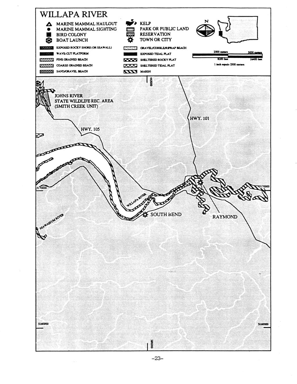
8 TOC WILLAPA BAY GRP 2. Site Description Willapa Bay is a 100 square-mile estuary situated along the southern coast of Washington and is one of the most important estuaries on the West Coast. The bay has an ideal oyster growing habitat, and supports a wide diversity of wildlife. Willapa Bay is considered to be one of the most productive bays along the Pacific. Salmon, bottom fish, oysters, crabs, clams, and shrimp are harvested from bay waters. The bay features mud and gravel beaches and saltgrass shores interspersed with wetlands and tidal flats. 20,000 acres of the bay has been set aside as a National Wildlife Refuge for habitat protection Physical Features Steeply rising uplands border the bay to the north and east. To the south, across a low ridge, lies the Columbia River. The western margin of the bay is formed by a long, narrow sand spit North Beach Peninsula apparently formed by deposits from the Columbia River Hydrology The drainage basin of Willapa Bay encompasses approximately 720 square miles, including most of Pacific County and portions of Grays Harbor, Lewis, and Wahkiakum counties. Rivers that flow into the bay include the Cedar, North, Willapa, Bone, Niawaikum, Palix, Nemah, Naselle, and Bear. Freshwater inflow into the bay from tributaries is low. The combined average daily runoff of all the rivers is approximately 0.004% of the bay volume Currents and Tides A majority of Willapa Bay is broad and shallow with about 55 percent of the area exposed at lower tides. The difference in the volume of water between highest tides and lowest tides is approximately 45 percent of the bay volume. At mean high water, Willapa Bay covers about 79,000 acres, while at mean lower low water about 32,000 acres of bottom are exposed and 11,600 acres are shallower than six feet. Conditions in the ocean determine how much water leaving the bay will return on the next incoming tide. According to the Army Corps of Engineers (1976), periods of ocean upwelling in summer promote thorough mixing of bay water and ocean water. Mixing may occur during storm periods with high wave actions. At other times, a plume of water from the Columbia River, acting as a discrete mass of water, tends to prevent mixing from occurring. Water from the bay can then move back and forth for several days. The ocean current along the Washington coast reverses direction between summer and winter; the California current moves south in the summer and the Davidson inshore current moves north in the winter. 2-1 March 2003
9 TOC WILLAPA BAY GRP 2.4. Winds During the fall and winter, there is a prevailing flow of warm, moist air from a southwesterly direction. During the winter, weather disturbances crossing the North Pacific follow a southerly course that results in an increased number of storms striking the Washington coast. The frequency of storms over the North Pacific decreases in the spring, and the prevailing wind shifts to westerly, and then northwesterly by early summer. In the fall, the winds again come from a westerly direction. If oil is spilled offshore, prevailing winds will play a role in spill direction depending on the season: In the winter, the predominant winds are from the south and the current is circulating north. If oil is spilled offshore south of Willapa Bay, and it enters the mouth, it can be expected to hit the northern shore of the bay. If the spill does not enter Willapa Bay, the North Coast shoreline will be vulnerable. In the summer, the predominant winds are from the north. The summer winds are persistent, but not as strong as the winter winds. Oil may enter Willapa Bay from the north and spread south. The increasingly variable nature of the winds in the spring, summer, and fall may reduce the predictability of the spill direction once it enters Willapa Bay Climate The climate of the Willapa Bay basin is the marine west coast type, characterized by cool, dry summers and moderate winters with heavy rainfall ranging from 65 to 120 inches per year, depending on location. 2-2 March 2003
10 Willapa Bay GRP Key Map Booming Strategy Locations March, 2003 Gray's Harbor GRP Willapa Bay Entrance Map # WB-1 WB-6 Not included in GRPs South Bend/Raymond Map # WB-2 WB-7 WB-8 WB-1 WB-2 WB-4 WB-5 WB-3 WB-17 WB-9 WB-10 WB-12 WB-11 WB-13 WB-49 WB-16 WB-18 WB-15 WB-48 WB-19 WB-20 WB-14 WB-47 WB-21 Not included in GRPs South Willapa Bay Map # WB-3 WB-24 WB-22 WB-30 WB-31 WB-29 WB-23 WB-32 WB-33 WB-25 WB-26 WB-34 WB-35 WB-44 WB-46 WB-41 WB-40 WB-27 WB-28 WB-45 WB-36 National Wildlife Refuge WB-42 WB-43 WB-39 WB-38 WB-37 Willapa Bay
11 TOC WILLAPA BAY GRP 4. GENERAL PROTECTION/COLLECTION STRATEGIES 4.1. Chapter Overview This chapter details the specific response strategies and resources to protect as outlined by the participants of the GRP workshop for the Willapa Bay area. It describes the strategies determined for each area and the prioritization of those strategies. Note that GRPs only address protection of sensitive public resources. It is the responsibility of private resource owners and/or potentially liable parties to address protection of private resources (such as commercial marinas, private water intakes, and non-release aquaculture facilities). Maps & Matrices The maps in this chapter provide information on the specific location of booming strategies. They are designed to help the responder visualize response strategies. Details of each booming strategy are listed in corresponding matrix tables. Each matrix indicates the exact location, intent and implementation of the strategy indicated on the map. The Status column describes whether the strategy has been visited or tested in the field, and the date of the visit/test. Most strategies include a number for the corresponding shoreline photo, which is available on the Washington Department of Ecology's internet site at Major Protection Techniques All response strategies fall into one of three major techniques that may be utilized either individually or in combination. The strategies listed in Section 4.2 are based on the following techniques, and are explained in detail in Section 4.3: Dispersants: Washington State Policy currently does not allow use of dispersants in this area. Certain chemicals break up slicks on the water. Dispersants can decrease the severity of a spill by speeding the dissipation of certain oil types. Their use will require approval of the Unified Command. Dispersants will only be used in offshore situations under certain conditions, until further determinations are made by the Area Committee and published in the Area Contingency Plan. In Situ Burning: Approval to burn in this area is unlikely due to the proximity of population to a potential burn site. Burning requires the authorization of the Unified Command, who determine conformance of a request to burn with the guidelines set forth in the Area Plan. This option is preferable to allowing a slick to reach the shore provided that population areas are not exposed to excessive smoke. Under the right atmospheric conditions, a burn can be safely conducted in relative close proximity to human population. This method works on many types of oil, and requires special equipment including a fire boom and igniters. Mechanical Recovery and Protection Strategies: If a spill is too close to shore to use In Situ burning or dispersants, the key strategies are skimming and use of collection, diversion, or exclusion booming to contain and recover the oil, and prevent it from entering areas with sensitive wildlife and fisheries resources. These options are described in detail in Appendix A. Specific skimming strategies are not listed in the maps and matrices, but skimming should be used whenever possible and is often the primary means of recovering oil and protecting resources, especially when booming is not possible or feasible. Priorities: The strategy priority tables (Section 4.2.) were developed using specific locations where spills are likely to occur. Trajectory modeling was used for each of these "Potential Spill Origins" to identify sensitive resources that would likely be impacted within the initial hours of the spill. A booming strategy priority table was developed for each of the "Potential Spill Origins" based on the sensitivity of resources, feasibility, etc. Booming strategies should be deployed following the priority table for the "Potential Spill Origin" closest to the actual spill origin. The map on page 4-2 shows the locations of all Potential Spill Origins for the Willapa Bay GRP. The booming strategies indicated in the priority tables are explained in detail in the Maps & Matrices section (Section 4.3.). It is implied that control and containment at the source is the number one priority of any response. If in the responder s best judgment this is not feasible, then the priorities laid out in the priority tables take precedence over containment and control. 4-1 March 2003
12 Willapa Bay GRP Potential Spill Origin Locations March, 2003 Gray's Harbor GRP Willapa Bay Entrance Map # WB-1 Not included in GRPs South Bend/Raymond Map # WB-2 WB-A WB-B Not included in GRPs South Willapa Bay Map # WB-3 National Wildlife Refuge Willapa Bay
13 TOC WILLAPA BAY GRP Table Booming Strategy Priority Tables Potential Spill Origin: WB-A - Oil entering Willapa Bay on a flood tide from a source outside of the bay BOOMING STRATEGY MAP PAGE COMMENTS PRIORITY NUMBER NUMBER 1 WB WB WB WB WB WB Tide Gate 7 WB Tide Gate 8 WB WB WB WB WB WB WB WB WB WB WB Tide Gate 19 WB WB March 2003
14 TOC WILLAPA BAY GRP Table 4-4 Potential Spill Origin: WB-B - Oil entering Willapa Bay on an ebb tide from a source in the Willapa River BOOMING STRATEGY MAP PAGE COMMENTS PRIORITY NUMBER NUMBER 1 WB WB WB WB WB WB WB WB WB WB March 2003

15 WILLAPA BAY ENTRANCE Proposed Booming Strategies Willapa Bay GRP MAP # 1 Map below 2 March, Miles 3 South Bay/Westprot - Gray's Harbor GRP - Map # 3 th Riv Cedar R WB-6 Willapa NWR Shoalwater Indian Reservation WB-1 Willapa NWR North Cove Graveyard Spit WB-2 Teal Duck Slough WB-4 WB-5 Kindred Slough WB-3 Tokeland Area not included in GRPs WB-A Leadbetter Point WB-48 Willapa NWR Grassy Island WB-49 Stony Point WB-18 Wilson Point Bone River WB-19 WB-20 South Bend/Raymond - Willapa Bay GRP - Map # 2 WB-47 Niawiakum R Leadbetter Point State Park WB-21 Palix River Legend Public Lands Tribal Lands Military Installations Potential Spill Origin Area not included in GRPs
16 SOUTH BEND/RAYMOND Proposed Booming Strategies Willapa Bay GRP MAP # 2 1 Map below March, Miles 3 Area not included in GRPs North River WB-7 WB-8 Smith Creek Johns River Wildlife Area Willapa Bay Entrance - Willapa Bay GRP - Map # 1 y Point one River WB-10 Willapa River WB-17 WB-16 Potter Slough WB-15 WB-12 WB-9 City of South Bend Johnson Slough WB-11 Mailboat Slough WB-13 WB-B WB-14 City of Raymond Area not included in GRPs -19 WB-20 Legend Niawiakum R Public Lands Tribal Lands Palix River Military Installations Potential Spill Origin Area not included in GRPs
17 SOUTH WILLAPA BAY Proposed Booming Strategies Willapa Bay GRP MAP # March, Miles Map below Area not included in GRPs Oysterville North Nemah R Nahcotta WB-24 WB-22 Area not included in GRPs Nahcotta Channel WB-30 WB-31 Lewis Slough Kaffee Slough Paradise Point WB-29 Lagergren Ranch Sunshine Point South Nemah R Middle Nemah R WB-23 Area not included in GRPs Long Beach Peninsula Willapa NWR WB-32 WB-33 Willapa Bay Long Island WB-34 Baldwin Slough Long Island Slough WB-35 WB-25 WB-27 Mill Ranch Naselle River Ellsworth Slough WB-28 WB-26 WB-46 Giles Slough Willapa NWR Pacific Park City of Long Beach WB-45 Area not included in GRPs WB-44 Parker Slough WB-42 WB-39 WB-43 WB-41 Bear Riv WB-40 WB-38 WB-36 WB-37 Legend Public Lands Tribal Lands Military Installations Potential Spill Origin
18 TOC WILLAPA BAY GRP Proposed Booming and Collection Strategies: Matrices Strategy Status Location Response Strategy Length of Boom Strategy Implementation Staging Area Site Access Resources Protected WB-1 North Cove PAC º 'N 124º 'W moving into marsh. 900' Deploy boom across the west opening to marsh. Area nearly dry at low tide. Tokeland Marina (PAC0042). By boat only from Tokeland Marina. Shorebird and WB-2 North Cove 46º 'N 124º 'W moving into marsh. 1500' Deploy boom at angle to close off east entrance to marsh. Place boom during flood tide or will need ATV's or helicopter. Area nearly dry at low tide. Tokeland Marina (PAC0042). By boat only from Tokeland Marina. Shorebird and WB-3 Kindred Slough PAC º 'N 123º 'W moving into slough. 2400' Install boom at an angle across slough entrance. Site can only be boomed at high tide. Tokeland Marina (PAC0042). By boat only from Tokeland Marina. Shorebird and WB-4 Kindred Slough Tide Gate PAC º 'N 123º 'W Keep oil out of slough. 100' Close tide gate. Deploy boom in front of tide gate if gate cannot be closed or if it leaks. Tokeland Marina (PAC0042). Must cross private farm land to get to tide gate, access from Highway 105 at north end of levee road. Permission is required or use helicopter. Shorebird and WB-5 Teal Duck Slough Tide Gate PAC º 'N 123º 'W Keep oil out of slough. 100' Close tide gate. Deploy boom in front of tide gate if gate cannot be closed or if it leaks. Tokeland Marina (PAC0042). Must cross private farm land to get to tide gate, access from Highway 105 at north end of levee road. Permission is required or use helicopter. Shorebird and WB-6 Cedar River PAC º 'N 123º 'W moving up river. 300' Install boom at an angle across river mouth downstream of bridge at Highway 105. River may have tide gate (need to verify). Stage on Hwy 105 at site. Take Hwy 105 from Raymond toward Tokeland. Salmon, concentrations. 4-8 March 2003
19 TOC WILLAPA BAY GRP Proposed Booming and Collection Strategies: Matrices Strategy Status Location Response Strategy Length of Boom Strategy Implementation Staging Area Site Access Resources Protected WB-7 North River PAC º 'N 123º 'W moving up river. 600' Install boom at an angle across river at bridge on Highway 105. North River Resort or Smith Take Hwy 105 west Creek. Both from Raymond to sites have launch North River Bridge, ramps miles. Salmon, concentrations. WB-8 Smith Creek PAC º 'N 123º 'W moving up creek. 400' Install boom at an angle across creek at bridge on Highway 105. Smith Creek boat launch. Take Hwy 105 west from Raymond to Smith Creek Bridge, 10 miles. Salmon, concentrations. WB-9 Fleiss Creek PAC º 'N 123º 'W moving into slough/ creek mouth. 200' Install boom at an angle across slough/ creek at bridge on Highway 105. Stage along Hwy 105. Take Hwy 105 from Raymond toward Tokeland. Go 5.4 miles from turnoff of Hwy 101 onto Hwy 105. Salmon, shorebird and WB-10 Johnson Slough Tide Gate PAC º 'N 123º 'W Keep oil out of slough. 100' Close tide gate. Deploy boom in front of tide gate if gate cannot be closed or if it leaks. Stage along Hwy 105. Take road from Highway 105 to Willapa Bay Airport, dike access road is off airport road. Shorebird and WB-11 Mailboat Slough (west entrance) PAC º 'N 123º 'W Keep oil out of slough. 1300' Deploy boom across slough entrance. Must install during high tide. Helen Davis Memorial Park at west end of South Bend. Park has boat launch. (PAC0145). From Raymond, go west on Hwy 101 to South Bend. Boat ramp is at west end of town. Shorebird and 4-9 March 2003
20 TOC WILLAPA BAY GRP Proposed Booming and Collection Strategies: Matrices Strategy Status Location Response Strategy Length of Boom Strategy Implementation Staging Area Site Access Resources Protected WB-12 Mailboat Slough (middle channel) PAC º 'N 123º 'W Keep oil out of slough. 100' Close tide gate. Deploy boom in front of tide gate if gate cannot be closed or if it leaks. Helen Davis Memorial Park at west end of South Bend. Park has boat launch. (PAC0145). From Raymond, go west on Hwy 101 to South Bend. Boat ramp is at west end of town. Shorebird and WB-13 Mailboat Slough (north channel) PAC º 'N 123º 'W Keep oil out of slough. 100' Close tide gate. Deploy boom in front of tide gate if gate cannot be closed or if it leaks. Helen Davis Memorial Park at west end of South Bend. Park has boat launch. (PAC0145). From Raymond, go west on Hwy 101 to South Bend. Boat ramp is at west end of town. Shorebird and WB-14 Mailboat Slough (east entrance) PAC º 'N 123º 'W moving into slough. 200' Deploy boom at an angle across slough entrance. Helen Davis Memorial Park at west end of South Bend. Park has boat launch. (PAC0145). From Raymond, go west on Hwy 101 to South Bend. Boat ramp is at west end of town. Shorebird and WB-15 Willapa River PAC º 'N 123º 'W Exclusion/ Collection - moving up or down river. 1000' Deploy boom at an deg. angle across river. Use boat launch for collection. This strategy can also be used for spills upstream to keep oil out of the bay. Helen Davis Memorial Park at west end of South Bend. Park has boat launch. (PAC0145). From Raymond, go west on Hwy 101 to South Bend. Boat ramp is at west end of town. Salmon, shorebird and 4-10 March 2003
21 TOC WILLAPA BAY GRP Proposed Booming and Collection Strategies: Matrices Strategy Status Location Response Strategy Length of Boom Strategy Implementation Staging Area Site Access Resources Protected WB-16 WB-17 WB-18 WB-19 WB-20 Potter Slough (south entrance) PAC º 'N 123º 'W Potter Slough (north entrance) PAC º 'N 123º 'W Bone River PAC º 'N 123º 'W Wilson Point Marsh PAC º 'N 123º 'W Niawiakum River PAC º 'N 123º 'W moving into slough. 250' moving into slough. 250' moving up river. 300' moving into marsh. 100' moving up river. 800' Deploy boom across slough entrance. Must install at high tide. Deploy boom across slough entrance. Must install at high tide. Deploy boom at an angle across river on west side of bridge on Highway 101. Deploy boom at an angle across marsh entrance near old BLM road. Deploy boom at an angle across river west of bridge on Highway 101. Helen Davis Memorial Park at west end of South Bend. Park has boat launch. (PAC0145). Helen Davis Memorial Park at west end of South Bend. Park has boat launch. (PAC0145). Stage at north end of Bone River Bridge just off Hwy 101. Stage near site where BLM logging road crosses marsh. Stage just off Hwy 101 at small oyster company on west side of Hwy, north side of river. From Raymond, go west on Hwy 101 to South Bend. Boat ramp is at west end of town. From Raymond, go west on Hwy 101 to South Bend. Boat ramp is at west end of town. Take Hwy 101 south from Raymond to Bone River. Take Hwy miles south from Raymond. Turn west onto BLM logging road and follow to marsh. Take Hwy miles south from Raymond to Niawiakum River. Shorebird and Shorebird and Salmon, shorebird and Shorebird and Salmon, shorebird and 4-11 March 2003
22 TOC WILLAPA BAY GRP Proposed Booming and Collection Strategies: Matrices Strategy Status Location Response Strategy Length of Boom Strategy Implementation Staging Area Site Access Resources Protected WB-21 Palix River PAC º 'N 123º 'W moving up river. 1200' Deploy boom at an angle across river west of bridge on Highway 101. Stage at boat launch just south of Palix River bridge. Take Hwy miles south from Raymond to Palix River. Site is on north side of river. Salmon, shorebird and WB-22 North Nemah River PAC º 'N 123º 'W moving up river. 750' Deploy boom at an angle across river mouth west of bridge on Highway 101. Difficult to boom at low water. Stage near Hwy Take Hwy 101 south 101 at N. Nemah from Raymond to N. River. Nemah River bridge. Salmon, shorebird and WB-23 Middle Nemah River PAC º 'N 123º 'W moving up river. 200' Deploy boom at an angle across river west of bridge on Highway 101. Stage off Hwy 101 on dirt road (Lagergren Ranch). Take Hwy 101 south from Raymond to Nemah River area. Salmon, shorebird and WB-24 South Nemah River PAC º 'N 123º 'W moving up river. 200' Deploy boom at an angle across river at bridge for Lagergren Ranch. Stage off Hwy 101 on dirt road (Lagergren Ranch). Take Hwy 101 south from Raymond to Nemah River area. Salmon, shorebird and WB-25 Naselle River PAC º 'N 123º 'W Exclusion/ Collection - moving up river. 2000' Deploy boom at an angle across river on east side of bridge at Highway 101 to collection site on north shore at old Mill Ranch. Stage at old Mill By boat only from the Ranch site (north Willapa NWR ramp side of Naselle near the south end of Bridge). Long Island. Salmon, shorebird and WB-26 Roaring Creek Slough 46º 'N 123º 'W moving into slough. 600' Deploy boom at an angle across slough entrance. Stage at old Mill By boat only from the Ranch site (north Willapa NWR ramp side of Naselle near the south end of Bridge). Long Island. Shorebird and 4-12 March 2003
23 TOC WILLAPA BAY GRP Proposed Booming and Collection Strategies: Matrices Strategy Status Location Response Strategy Length of Boom Strategy Implementation Staging Area Site Access Resources Protected WB-27 Ellsworth Slough 46º 'N 123º 'W moving into slough. 600' Deploy boom across slough entrance north of bridge at Parpala Road. Stage at Ellsworth Slough just off of Parpala Road. Take Hwy 101 south from Raymond to Naselle River Bridge. Cross bridge and take first left (Parpala Road). Shorebird and WB-28 Smith Creek 46º 'N 123º 'W moving up creek. 400' Deploy boom across creek mouth north of bridge at Parpala Road. Stage along Parpala Road. Take Hwy 101 south from Raymond to Naselle River Bridge. Cross bridge and take first left (Parpala Road). Salmon, shorebird and WB-29 Sunshine Point PAC º 'N 123º 'W moving into Naselle River or Long Island Slough. 2400' Deploy boom at an angle across channel from Sunshine Point to Paradise Point. Stage at Willapa By boat only at high Bay NWR tide from the Willapa Headquarters NWR ramp near the and boat launch south end of Long area (PAC0295). Island. National Wildlife Refuge - shorebird and concentrations, seal haulouts, slough and marsh habitat. WB-30 Lewis Slough PAC º 'N 123º 'W moving into slough. 1000' Deploy boom at an angle across slough entrance. Need high tide to boom. Need Refuge permission to access site. Stage at Willapa By boat only at high Bay NWR tide from the Willapa Headquarters NWR ramp near the and boat launch south end of Long area (PAC0295). Island. National Wildlife Refuge - shorebird and concentrations, seal haulouts, slough and marsh habitat. WB-31 Kaffee Slough PAC º 'N 123º 'W moving into slough. 450' Deploy boom at an angle across slough entrance. Need high tide to boom. Need Refuge permission to access site. Stage at Willapa By boat only at high Bay NWR tide from the Willapa Headquarters NWR ramp near the and boat launch south end of Long area (PAC0295). Island. National Wildlife Refuge - shorebird and concentrations, seal haulouts, slough and marsh habitat March 2003
24 TOC WILLAPA BAY GRP Proposed Booming and Collection Strategies: Matrices Strategy Status Location Response Strategy Length of Boom Strategy Implementation Staging Area Site Access Resources Protected WB-32 Baldwin Slough (north entrance) PAC º 'N 123º 'W moving into slough. 400' Deploy boom at an angle across north slough entrance. Need high tide to boom. Need Refuge permission to access site. Stage at Willapa By boat only at high Bay NWR tide from the Willapa Headquarters NWR ramp near the and boat launch south end of Long area (PAC0295). Island. National Wildlife Refuge - shorebird and concentrations, seal haulouts, slough and marsh habitat. WB-33 Baldwin Slough (south entrance) PAC º 'N 123º 'W moving into slough. 400' Deploy boom at an angle across south slough entrance. Need high tide to boom. Need Refuge permission to access site. Stage at Willapa By boat only at high Bay NWR tide from the Willapa Headquarters NWR ramp near the and boat launch south end of Long area (PAC0295). Island. National Wildlife Refuge - shorebird and concentrations, seal haulouts, slough and marsh habitat. WB-34 Long Island Slough PAC º 'N 123º 'W moving into slough. 900' Install boom across slough. Need Refuge permission to access site. Stage at Willapa By boat only at high Bay NWR tide from the Willapa Headquarters NWR ramp near the and boat launch south end of Long area (PAC0295). Island. National Wildlife Refuge - shorebird and concentrations, seal haulouts, slough and marsh habitat. WB-35 Lake at Willapa National Wildlife Refuge Headquarters PAC º 'N 123º 'W Keep oil out of lake. 100' Block culvert with boom or plywood. Discharge from lake will normally keep oil out. Could enter only at high tide. Stage at Willapa Bay NWR Headquarters and boat launch area (PAC0295). Take Hwy 101 south from Raymond to Willapa NWR Headquarters near south end of Long Island. National Wildlife Refuge - concentrations March 2003
25 TOC WILLAPA BAY GRP Proposed Booming and Collection Strategies: Matrices Strategy Status Location Response Strategy Length of Boom Strategy Implementation Staging Area Site Access Resources Protected WB-36 Tidal marsh at mouth of Bear River PAC º 'N 123º 'W moving into tidal marsh. 400' Deploy boom across tidal marsh entrance west of bridge at Highway 101. Stage at Highway 101. Take Hwy 101 south from Raymond. Deploy boom at bridge at mouth of Bear River. Boat access at high tide only from the refuge ramp. Shorebird and WB-37 Bear River (main channel) PAC º 'N 123º 'W moving up river. 350' Deploy boom across river mouth near bridge at WB-36. Stage at Highway 101. Take Hwy 101 south from Raymond. Deploy boom near bridge at mouth of Bear River. Boat access only from the refuge ramp. National Wildlife Refuge - salmon, concentrations. WB-38 Bear River (west channel) PAC º 'N 123º 'W moving up river. 150' Install boom at an angle across river entrance. Refuge permission required. Stage at Willapa Bay NWR Headquarters and boat launch area (PAC0295). Take Hwy 101 south from Raymond. After crossing bridge at mouth of Bear River, take Jeldness Road to dike access road. Boat access at high tide only. National Wildlife Refuge - salmon, shorebird and WB-39 WBNWR Tide Gate #1 PAC º 'N 123º 'W Keep oil out of slough. 100' Close tide gate. Deploy boom in front of tide gate if gate cannot be closed or if the gate leaks. Refuge permission required. Stage at Willapa Bay NWR Headquarters and boat launch area (PAC0295). Take Hwy 101 south from Raymond. After crossing bridge at mouth of Bear River, take Jeldness Road to dike access road. National Wildlife Refuge - shorebird and 4-15 March 2003
26 TOC WILLAPA BAY GRP Proposed Booming and Collection Strategies: Matrices Strategy Status Location Response Strategy Length of Boom Strategy Implementation Staging Area Site Access Resources Protected WB-40 WBNWR Tide Gate #2 PAC º 'N 123º 'W Keep oil out of slough. 100' Close tide gate. Deploy boom in front of tide gate if gate cannot be closed or if the gate leaks. Refuge permission required. Stage at Willapa Bay NWR Headquarters and boat launch area (PAC0295). Take Hwy 101 south from Raymond. After crossing bridge at mouth of Bear River, take Jeldness Road to dike access road. National Wildlife Refuge - shorebird and WB-41 WBNWR Tide Gate #3 PAC º 'N 123º 'W Keep oil out of slough. 100' Close tide gate. Deploy boom infront of tide gate if gate cannot be closed or if the gate leaks. Refuge permission required. Stage at Willapa Bay NWR Headquarters and boat launch area (PAC0295). Take Hwy 101 south from Raymond. After crossing bridge at mouth of Bear River, take Jeldness Road to dike access road. National Wildlife Refuge - shorebird and WB-42 Parker Slough PAC º 'N 124º 'W Keep oil out of slough. 900' Deploy boom at an angle across slough entrance. Need Refuge permission to access site. Stage at Willapa Bay NWR Headquarters and boat launch area (PAC0295). Take Hwy 101 south from Raymond. After crossing bridge at mouth of Bear River, take Jeldness Road to Parker Slough. National Wildlife Refuge - shorebird and WB-43 Parker Slough Tide Gate PAC º 'N 124º 'W Keep oil out of slough. 100' Close tide gate. Deploy boom in front of tide gate if gate cannot be closed or if the gate leaks. Refuge permission required. Stage at Willapa Bay NWR Headquarters and boat launch area (PAC0295). Follow directions for WB-44, continue on dike access road to tide gate. National Wildlife Refuge - shorebird and WB-44 Tarlatt Slough Tide Gate PAC º 'N 124º 'W Keep oil out of slough. 100' Close tide gate. Deploy boom in front of tide gate if gate cannot be closed or if the gate leaks. Stage at Willapa Bay NWR Headquarters and boat launch area (PAC0295). Take Hwy 101 to Peninsula Highway, go north to dirt road 1300' past Pioneer Road, dirt road leads to tide gate. Shorebird and 4-16 March 2003
27 TOC WILLAPA BAY GRP Proposed Booming and Collection Strategies: Matrices Strategy WB-45 WB-46 WB-47 WB-48 WB-49 Status Location Tarlatt Slough PAC º 'N 124º 'W Giles Slough PAC º 'N 124º 'W Grassy Island (south) PAC º 'N 124º 'W Response Strategy moving into slough. 480' moving into slough. 900' Keep oil from moving into marsh area. 1700' Grassy Island (north) PAC0438 Keep 46º 'N 124º 'W oil from moving into marsh area. 1000' Gunpowder Sands 46º 'N 124º-0.996'W Deflection - Deflect oil into main channel. 2000' Length of Boom Strategy Implementation Staging Area Site Access Resources Protected Deploy boom at an angle across slough entrance. Deploy boom at an angle across slough entrance. Deploy boom at south end of Grassy Island, high tide only. Boat access only at high tide, use ramp at Willapa Bay NWR Stage at Willapa Headquarters or Bay NWR Nahcotta. Need Headquarters Willapa NWR and boat launch permission to access area (PAC0295). site. Boat access only at high tide, use ramp at Willapa Bay NWR Stage at Willapa Headquarters or Bay NWR Nahcotta. Need Headquarters Willapa NWR and boat launch permission to access area (PAC0295). site. Stage at Nahcotta Marina (PAC0403), west of Ocean Park. Stage at Deploy boom at north end of Grassy Island, high tide only. Entrance to marsh is variable and may be blocked with sand. Angle boom southeast from east side of Gunpowder Sands to deflect oil away. Nahcotta Marina (PAC0403), west of Ocean Park. Stage at Nahcotta Marina (PAC0403), west of Ocean Park. Boat access only at high tide, use ramp at Nahcotta or Tokeland. Need Willapa NWR permission to access site. Boat access only at high tide, use ramp at Nahcotta or Tokeland. Need Willapa NWR permission to access site. Shorebird and Shorebird and National Wildlife Refuge - shorebird and concentrations, marsh habitat. National Wildlife Refuge - shorebird and concentrations, marshes. Boat access only at high tide, use ramp at Nahcotta or Tokeland. Need Willapa NWR permission to access Shorebirds and site March 2003
28 WILLAPA BAY GRP 5. Shoreline Information 5.1. Shoreline Types and Sensitivity The type of shoreline, degree of exposure to waves and currents, and biological sensitivity are the main criteria for selecting appropriate treatment techniques. Each shoreline type has particular properties (including vegetation types) which facilitate or resist the penetration and persistence of oil. Areas of comparatively uniform sediment type and grain size experience a deeper penetration of oil. Grain size definitions are: Mud Fine Sand Medium to Coarse Sand Pebble/Cobble < mm mm 2-4 mm mm Persistence of oil in a particular area is directly related to the intensity of wave action, tides, and currents. Based on numerous oil spill studies of shoreline characteristics, treatment, and oil impact, the matrices in Chapter 5 were formulated following the basic prototype of the Environmental Sensitivity Index Atlas. The environmental sensitivity index (ESI) system ranks coastal environments on a scale of 1-10 or 11 (less sensitive to more sensitive) with respect to oil spill sensitivity and potential biological injury. ESI is being used for mapping extensive areas of the coastline of the U.S. Generally speaking, areas exposed to high levels of physical energy, such as wave action and tidal currents, rank low on the scale while sheltered areas have the highest ranking. The shoreline types used in this manual are a combination of the two similar systems used for the Delaware/Pennsylvania/New Jersey ESI Atlas, and the Maryland and Virginia atlases. The numbering system for the Countermeasure Manual Shoreline Types does not correspond exactly to either atlas; however, the corresponding shoreline types can be identified easily from the ESI maps and reassigned the appropriate number (after field verification.) The shoreline ranking system provides a useful first step in the design of contingency plans because it identifies the priority areas that require maximum effort for protection and cleanup. Strike teams and contractors with this document can focus their activities on environmental priorities, particularly during the first few hours and days of the spill. 8 8 Regional Response Team III. Draft, Shoreline Countermeasures Manual. (Department of the Interior, March 22,1991). 5-1 March15, 1994
29 WILLAPA BAY GRP 5.3 Shoreline Countermeasure Matrices The matrices included here show which shoreline countermeasure techniques have been considered for the fourteen shoreline types described in Chapter 2 of the Shoreline Countermeasures Manual & Matrices, Northwest Area Plan, Chapter 9650, Page Four matrices have been constructed for the major categories of oil (heavy, medium, light, very light). Countermeasure methods are described in Chapters 3 and 4 of the manual. Countermeasures in Chapter 3 are traditional or conventional techniques that the OSC can use without any additional concurrence. However, the cutting of vegetation countermeasure should be used only during specific seasonal windows under specific conditions and with landowner approval. Countermeasures in Chapter 4 are described under a separate section called Shoreline Countermeasure Methods Using Alternative Technology may be useful in certain situations. These methods are considered more experimental and controversial in their application and potential impacts and require more formal review and consultation before implementing. The exact requirements are spelled out in the National Contingency Plan and the Northwest Area Plan. The Shoreline Countermeasures Matrices are a particularly dynamic component of the manual and should continue to be revised as the existing techniques are used and evaluated, and as both old and new techniques are refined. Each matrix has a written explanation of how it is to be used as a countermeasure advisability matrix. The matrices are only a general guide for removing oil from shoreline substrates. They must be used in conjunction with the entire Shoreline Countermeasures Manual plus field observations and scientific advice. The countermeasures listed are not necessarily the best under all circumstances, and any listed technique may need to be used in conjunction with other techniques (including ones not listed herein). The Federal On-Scene Coordinator (FOSC) or the State OSC operating with the FOSC's authorization has the responsibility for and authority to determine which countermeasure(s) are appropriate for the various situations encountered. Selection of countermeasure techniques to be used in each spill is based upon the degree of oil contamination, shoreline types, and the presence of sensitive resources. Extremely sensitive areas are generally limited to manual cleanup methods. It is important to note that the primary goal of countermeasure implementation is the removal of oil from the shoreline with no further injury or destruction to the environment. The three categories of guidance used in the matrices are defined as follows: R Recommended May be the preferred method that best achieves the goal of minimizing destruction or injury to the environment C Conditional Viable and possibly useful but may result in limited adverse effects to the environment Shaded Not applicable or not generally recommended. 5-9 March 2003
30 SHORELINE COUNTERMEASURES MATRIX Heavy Oil (Heavy Crude Oils, Intermediate Fuel Oils, Bunker C & Heavily Weathered Medium Crudes) Heavy oils with little or no evaporation or dissolution Water-soluble fraction likely to be <10ppm Heavy contamination of intertidal areas likely Severe impacts to and fur-bearing mammals (coating and ingestion) Long-term contamination to sediments possible Weathers very slowly Dispersion seldom effective Shoreline cleanup difficult under all conditions SHORELINE TYPES CODES 1- Exposed rock shores and vertical, hard man-made structure (e.g. seawalls) 2 - Exposed wave-cut platforms 3 - Fine to medium grained sand beaches & steep unvegetated river banks 4 - Course grained sand beaches 5 - Mixed sand and gravel beaches, including artificial fill containing a range of grain size and material 6A - Gravel beaches - pebbles to cobble 6B - Gravel beaches - cobbles to boulders 6C - Exposed rip rap 7 - Exposed tidal flat 8A- Sheltered vertical rock shores and vertical, hard man-made structures (e.g. seawalls, docks, bulkheads) 8B - Sheltered rubble slope 9A - Sheltered sand and mud flats 9B - Sheltered vegetated low bank 10 - Marshes SHORELINE TYPES COUNTERMEASURES A 6B 6C 7 8A 8B 9A 9B 10 CONVENTIONAL METHODS No action C C C C C C C C R C C R C R Manual removal of oil C R R R R C C C R R C C Passive collection of oil R R R R R R R R C R R C R R Oiled debris removal C R R R R R R R C R R C R C Trenching/recovery wells C C C Oiled sediment removal C C C C C C Ambient water flooding (Deluge) C C C R R R R R C C Amb water flush <50 psi C C C R C R C C C C Amb water flush <100 psi C C C C C C Warm water flush <90 F C C C C Hot water flush >90 F C C Vacuum removal of oil C C C C C C C C C C C C Sediment reworking C C C C Sediment Removalcleaning-replacement C C C C C Cutting oiled vegetation C C C C C C ALTERNATIVE METHODS* In-situ burning on shore Chemical stabilization, protection, cleaning Nutrient enhancement C C C C C C C Microbial addition R Recommend - May be Preferred Alternative C Conditional (Refer to NW Shoreline Countermeasures Manual) Shaded areas are Not Applicable or Not Generally Recommened * Follow approved process defined in NCP and NW Area Plan This countermeasure advisability matrix is only a general guide for removal of oil from shoreline substrates. It must be used in conjunction with the entire Shoreline Countermeasures Manual plus field observations and scientific advice. The countermeasures listed are not necessarily the best under all circumstances, and any listed technique may need to be used in conjunction with other techniques (including ones not listed herein). The Federal On-Scene Coordinator (FOSC) or the state OSC operating with the FOSC's authorization has the responsibility for and the authority to determine which countermeasure(s) are appropriate for various situations encountered. Selection of countermeasures is based on the degree of oil contamination, the shoreline type, and the presence of sensitive resources.
31 SHORELINE COUNTERMEASURES MATRIX Medium Oil (Most Crude Oils & Some Heavily Weathered Light Crudes) About 1/3 will evaporate within 24 hours Maximum water-soluble fraction is ppm Oil contamination of intertidal areas can be severe and long-term Impact to and fur-bearing mammals can be severe Chemical dispersion is an option within 1-2 days Cleanup most effective if conducted quickly SHORELINE TYPES CODES 1- Exposed rock shores and vertical, hard man-made structure (e.g. seawalls) 2 - Exposed wave-cut platforms 3 - Fine to medium grained sand beaches & steep unvegetated river banks 4 - Course grained sand beaches 5 - Mixed sand and gravel beaches, including artificial fill containing a range of grain size and material 6A - Gravel beaches - pebbles to cobble 6B - Gravel beaches - cobbles to boulders 6C - Exposed rip rap 7 - Exposed tidal flat 8A- Sheltered vertical rock shores and vertical, hard man-made structures (e.g. seawalls, docks, bulkheads) 8B - Sheltered rubble slope 9A - Sheltered sand and mud flats 9B - Sheltered vegetated low bank 10 - Marshes SHORELINE TYPES COUNTERMEASURES A 6B 6C 7 8A 8B 9A 9B 10 CONVENTIONAL METHODS No action C C C C C C C C R C C R C R Manual removal of oil C R R R R C C C R R C C Passive collection of oil R R R R R R R R C R R R R R Oiled debris removal C R R R R R R R C R R C R C Trenching/recovery wells C C C Oiled sediment removal C C C C C Ambient water flooding (Deluge) C C C R R R R R C C Amb water flush <50 psi C C C R C R R R C C Amb water flush <100 psi C C C C C Warm water flush <90 F C C C C Hot water flush >90 F C C Vacuum removal of oil C C R R C R R C C C C Sediment reworking C C C C Sediment Removalcleaning-replacement C C C C C C Cutting oiled vegetation C C C C C C ALTERNATIVE METHODS* In-situ burning on shore Chemical stabilization, protection, cleaning Nutrient enhancement C C C C C C C C Microbial addition R Recommend - May be Preferred Alternative C Conditional (Refer to NW Shoreline Countermeasures Manual) Shaded areas are Not Applicable or Not Generally Recommened * Follow approved process defined in NCP and NW Area Plan This countermeasure advisability matrix is only a general guide for removal of oil from shoreline substrates. It must be used in conjunction with the entire Shoreline Countermeasures Manual plus field observations and scientific advice. The countermeasures listed are not necessarily the best under all circumstances, and any listed technique may need to be used in conjunction with other techniques (including ones not listed herein). The Federal On- Scene Coordinator (FOSC) or the state OSC operating with the FOSC's authorization has the responsibility for and the authority to determine which countermeasure(s) are appropriate for various situations encountered. Selection of countermeasures is based on the degree of oil contamination, the shoreline type, and the presence of sensitive resources.
32 SHORELINE COUNTERMEASURES MATRIX Light Oil (Diesel, No 2 Fuel Oils, Light Crudes) Moderately volatile; will leave residue (up to 1/3 of spilled amount) Moderate concentrations of toxic (soluble) compounds Long-term contamination of intertidal resources possible Potential for subtidal impacts (dissolution, mixing, sorption onto suspended sediments) No dispersion necessary Cleanup can be very effective SHORELINE TYPES CODES 1- Exposed rock shores and vertical, hard man-made structure (e.g. seawalls) 2 - Exposed wave-cut platforms 3 - Fine to medium grained sand beaches & steep unvegetated river banks 4 - Course grained sand beaches 5 - Mixed sand and gravel beaches, including artificial fill containing a range of grain size and material 6A - Gravel beaches - pebbles to cobble 6B - Gravel beaches - cobbles to boulders 6C - Exposed rip rap 7 - Exposed tidal flat 8A- Sheltered vertical rock shores and vertical, hard man-made structures (e.g. seawalls, docks, bulkheads) 8B - Sheltered rubble slope 9A - Sheltered sand and mud flats 9B - Sheltered vegetated low bank 10 - Marshes SHORELINE TYPES COUNTERMEASURES A 6B 6C 7 8A 8B 9A 9B 10 CONVENTIONAL METHODS No action R R C C C C C C R C C R C R Manual removal of oil C C C C C C R R C Passive collection of oil C R R R R R R R C R R C R R Oiled debris removal C C R R R R R R C R R C C C Trenching/recovery wells C C C Oiled sediment removal C C C C Ambient water flooding (Deluge) C C C R R R C C Amb water flush <50 psi C C C C C R C C Amb water flush <100 psi Warm water flush <90 F Hot water flush >90 F Vacuum removal of oil C C C Sediment reworking C C C C Sediment Removalcleaning-replacement C C C Cutting oiled vegetation C C C C C C ALTERNATIVE METHODS* In-situ burning of shore Chemical stabilization, protection, cleaning Nutrient enhancement C C C C C C C Microbial addition R Recommend - May be Preferred Alternative C Conditional (Refer to NW Shoreline Countermeasures Manual) Shaded areas are Not Applicable or Not Generally Recommened * Follow approved process defined in NCP and NW Area Plan This countermeasure advisability matrix is only a general guide for removal of oil from shoreline substrates. It must be used in conjunction with the entire Shoreline Countermeasures Manual plus field observations and scientific advice. The countermeasures listed are not necessarily the best under all circumstances, and any listed technique may need to be used in conjunction with other techniques (including ones not listed herein). The Federal On-Scene Coordinator (FOSC) or the state OSC operating with the FOSC's authorization has the responsibility for and the authority to determine which countermeasure(s) are appropriate for various situations encountered. Selection of countermeasures is based on the degree of oil contamination, the shoreline type, and the presence of sensitive resources.
33 SHORELINE COUNTERMEASURES MATRIX Very Light Oil (Jet fuels, Gasoline) Highly volatile (should all evaporate within 1-2 days) High concentration of toxic (soluble) compounds Result: Localized, severe impacts to water column and intertidal resources Duration of impact is a function of the resource recovery rate No dispersion necessary SHORELINE TYPES CODES 1- Exposed rock shores and vertical, hard man-made structure (e.g. seawalls) 2 - Exposed wave-cut platforms 3 - Fine to medium grained sand beaches & steep unvegetated river banks 4 - Course grained sand beaches 5 - Mixed sand and gravel beaches, including artificial fill containing a range of grain size and material 6A - Gravel beaches - pebbles to cobble 6B - Gravel beaches - cobbles to boulders 6C - Exposed rip rap 7 - Exposed tidal flat 8A- Sheltered vertical rock shores and vertical, hard man-made structures (e.g. seawalls, docks, 8B - Sheltered rubble slope 9A - Sheltered sand and mud flats 9B - Sheltered vegetated low bank 10 - Marshes SHORELINE TYPES COUNTERMEASURES A 6B 6C 7 8A 8B 9A 9B 10 CONVENTIONAL METHODS No action R R R R R R R R R R R R R R Manual removal of oil Passive collection of oil C C C C C C Oiled debris removal C C C C C C C C C C C C C C Trenching/recovery wells C C C Oiled sediment removal Ambient water flooding (Deluge) C Amb water flush <50 psi Amb water flush <100 psi Warm water flush <90 F Hot water flush >90 F Vacuum removal of oil Sediment reworking C C C C Sediment Removalcleaning-replacement Cutting oiled vegetation ALTERNATIVE METHODS* In-situ burning on shore Chemical stabilization, protection, cleaning Nutrient enhancement Microbial addition R Recommend - May be Preferred Alternative C Conditional (Refer to NW Shoreline Countermeasures Manual) Shaded areas are Not Applicable or Not Generally Recommened * Follow approved process defined in NCP and NW Area Plan This countermeasure advisability matrix is only a general guide for removal of oil from shoreline substrates. It must be used in conjunction with the entire Shoreline Countermeasures Manual plus field observations and scientific advice. The countermeasures listed are not necessarily the best under all circumstances, and any listed technique may need to be used in conjunction with other techniques (including ones not listed herein). The Federal On-Scene Coordinator (FOSC) or the state OSC operating with the FOSC's authorization has the responsibility for and the authority to determine which countermeasure(s) are appropriate for various situations encountered. Selection of countermeasures is based on the degree of oil contamination, the shoreline type, and the presence of sensitive resources.
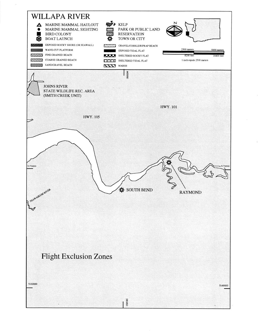
34 Purpose of Chapter 6 The information presented in this chapter highlights some of the more significant environmentally sensitive areas within the GRP region that could be impacted as a result of an oil spill. Consistent with the overall purpose of the GRP s, this information is only intended to provide a level of detail required during the initial phase of spill response. During an actual event, additional resource information will be available from the resource trustee agencies supporting the Environmental Unit in the Planning Section. Specific resource concerns for areas that already have designated protection strategies in Chapter 4 of the GRP may be found in the Resources Protected column in the matrix describing the individual strategies. The information provided in Chapter 6 is intended for use in: o Preparing an initial ICS 232 form (Resources-at-Risk summary) for Incident Command o Identifying those sites where it may be necessary to implement Flight Restriction Zones in order to prevent disturbance/injury to sensitive wildlife species. o Identifying sensitive shoreline habitats to assist SCAT teams in their initial assessments and to help personnel in the Environmental Unit in developing appropriate cleanup strategies. Chapter 6 consists of two sets of maps and tables - one for wildlife and the other for fish, shellfish and selected sensitive marine habitats. These data are presented separately, both for ease of reading and because each of the two data sets has slightly different applications within the context of spill response. The wildlife maps and tables present information on the location and seasonal sensitivity of key wildlife resources. Types of data included here are concentration areas for, marine birds and shorebirds; seabird colonies; nesting areas for sensitive species such as eagles, herons and falcons; and marine mammal haulout sites. This information is intended for the rapid identification of areas where significant wildlife oiling impacts could be anticipated and to denote areas where flight restriction zones may be required to protect sensitive wildlife. Each site depicted on these maps is identified by a unique number in order to facilitate the process of communicating Flight Restriction Zone recommendations to the Operations Section in ICS. The tables accompanying the wildlife maps present information on the season(s) during which sites may be particularly sensitive to disturbance. The fish/shellfish/marine habitat maps present general information on the location of baitfish spawning beaches, herring spawning areas, streams used by anadromous salmonids, hardshell clam concentrations, and kelp and eelgrass beds. This information will be most useful to personnel involved in assessing initial risks to fish and shellfish resources and to those conducting initial beach reconnaissance, pending availability of more detailed resource information and the formation of SCAT teams. Because the operational uses of this information differ from those of the wildlife data, individual site identification numbers have not been assigned. Tables associated with these maps will identify the seasonal sensitivity of each resource. In addition, notes accompanying each table will provide information on the general distribution and seasonal sensitivity of those resources that are not mapped but may occur anywhere in the GRP region (ex. juvenile salmonids in shallow nearshore waters).
35
36

37
38

39
40
41
42
Spokane River Geographic Response Plan - Update
 Linda Pilkey-Jarvis Washington Department of Ecology June 2011 Spokane River Geographic Response Plan - Update Spokane River - Latah Creek - Marshall Creek - Spring Creek - Chamokane Creek Little Spokane
Section Decanting Response Tool
 Section 9411 Decanting Response Tool T able of Contents Section Page 9411 Decanting Response Tool... 9411-1 9411.1 Introduction... 9411-1 9411.2 Decanting Policy... 9411-1 9411.2.1 Criteria... 9411-1 9411.2.2
Puget Sound Nearshore Ecosystem Restoration Project Restore America s Estuaries Conference 2012 Tampa, FL
 Restore America s Estuaries Conference 2012 Tampa, FL presented by: Theresa Mitchell, WA Dept. of Fish & Wildlife Nearshore General Investigation Change Analysis: Comparison of historical and current
Section Decanting Response Tool
 Section 9411 Decanting Response Tool T able of Contents Section Page 9411 Decanting Response Tool... 9411-1 9411.1 Introduction... 9411-1 9411.2 Decanting Policy... 9411-1 9411.2.1 Criteria... 9411-1 9411.2.2
SUCCESSFUL GEAR RECOVERY Lessons from Puget Sound
 APEC MARINE DEBRIS SEMINAR SUCCESSFUL GEAR RECOVERY Lessons from Puget Sound Jeff June, Project Manager Joe Schmitt & Gary Wood JD Northwest Straits Commission Washington State, U.S. The Northwest Straits
NORTH OREGON COAST GEOGRAPHIC RESPONSE PLAN (GRP)
") Northwest Area Committee NORTH OREGON COAST GEOGRAPHIC RESPONSE PLAN (GRP) AREA OF COVERAGE PACIFIC OCEAN Spill Response Contact Sheet Required Notifications For Hazardous Substance Or Oil Spills USCG
Northwest Area Committee NORTH OREGON COAST GEOGRAPHIC RESPONSE PLAN (GRP) AREA OF COVERAGE PACIFIC OCEAN Spill Response Contact Sheet Required Notifications For Hazardous Substance Or Oil Spills USCG
Estuarine Shoreline Stabilization
 Estuarine Shoreline Stabilization Property Owner s Guide to Determining the Most Appropriate Stabilization Method Estuarine shorelines are dynamic features that experience continued erosion. Land is lost
Oil Spill Incident Annex. Introduction [Link to the Oil and Hazardous Materials Incident Annex in the NRP]
![Oil Spill Incident Annex. Introduction [Link to the Oil and Hazardous Materials Incident Annex in the NRP]](/thumbs/89/100738091.jpg "Oil Spill Incident Annex. Introduction [Link to the Oil and Hazardous Materials Incident Annex in the NRP]") Introduction [Link to the Oil and Hazardous Materials Incident Annex in the NRP] Response to oil spills can vary greatly, involving only a few people or thousands. The initial action taken by responders
Introduction [Link to the Oil and Hazardous Materials Incident Annex in the NRP] Response to oil spills can vary greatly, involving only a few people or thousands. The initial action taken by responders
EVALUATING THE EFFECTS OF BIVALVE SHELLFISH AQUACULTURE AND ITS ECOLOGICAL ROLE IN THE ESTUARINE ENVIRONMENT IN THE UNITED STATES
 EVALUATING THE EFFECTS OF BIVALVE SHELLFISH AQUACULTURE AND ITS ECOLOGICAL ROLE IN THE ESTUARINE ENVIRONMENT IN THE UNITED STATES Brett Dumbauld USDA Agricultural Research Service, Hatfield Marine Science
Chief-Planning & Readiness USCG Sector Houston-Galveston
 Boom Efficacy During the DEEPWATER HORIZON Response LCDR Joseph J. Leonard, Jr. Chief-Planning & Readiness USCG Sector Houston-Galveston June 2011 Boom Selection Responder Skill Sets Boom Utilization Site
X.B WETLANDS ROGUE RIVER ESTUARY
 X.B WETLANDS ROGUE RIVER ESTUARY The Rogue River has a drainage area of 5,100 square miles, yet the estuary of the Rogue River is one of the smallest in Oregon, measuring approximately 1,880 acres during
Tide Gate Modifications for Fish Passage and Water Quality Enhancement
 Tide Gate Modifications for Fish Passage and Water Quality Enhancement Tillamook Bay National Estuary Project 613 Commercial St. PO Box 493 Garibaldi, OR 97118 Phone (503) 322-2222 Fax (503) 322-2261 Jay
XXX. Chisolm Island Creeks. Map Continued on SC-48. Judge Island. SC49-03 Jenkins Creek/Morgan River Intersection XXX. Saint Helena Island
 w River 32 30'0"N ufort County 80 37'30"W 802 Coosaw River 250 450 SC41-05 Geographic Response SC41-03 Plan Map: Coosaw SC-49 River Chisolm Island Chisolm Island s u Map Continued on SC-41 3 (west side)
San Diego Shorebird Survey Tijuana River Survey Areas
 San Diego Shorebird Survey Tijuana River Survey Areas Legend Survey Area North McCoy South McCoy Helicopter Airfield North River Mouth- Beach North River Mouth-Marsh South River Mouth- Marsh South River
Lecture Outlines PowerPoint. Chapter 15 Earth Science, 12e Tarbuck/Lutgens
 Lecture Outlines PowerPoint Chapter 15 Earth Science, 12e Tarbuck/Lutgens 2009 Pearson Prentice Hall This work is protected by United States copyright laws and is provided solely for the use of instructors
APPENDIX D-2. Sea Level Rise Technical Memo
 APPENDIX D-2 Sea Level Rise Technical Memo 2185 N. California Blvd., Suite 500 Walnut Creek, CA 94596 (925) 944-5411 Fax: (925) 944-4732 www.moffattnichol.com DRAFT MEMORANDUM To: From: Neil Nichols,
Chapter 10 Lecture Outline. The Restless Oceans
 Chapter 10 Lecture Outline The Restless Oceans Focus Question 10.1 How does the Coriolis effect influence ocean currents? The Ocean s Surface Circulation Ocean currents Masses of water that flow from one
CountySouth Puget Sound
 Canada Whatcom County Vancouver Island British Columbia San Juan County Skagit County Island County Clallam County Snohomish County Jefferson County Kitsap County King County Grays Harbor County Mason
County of Santa Barbara Permit Option Analysis Goleta Beach JULY 13, 2017
 County of Santa Barbara Permit Option Analysis Goleta Beach JULY 13, 2017 Introduction 2 Goleta Beach Park welcomes 1.5 million visitors annually Amenities include: Picnic Areas and Group Areas w/bbqs
GOAL: Collect product flowing over Onalaska spillway to protect downstream resources C&C 250 Y Y. Looking upstream at spillway
 GOAL: Collect product flowing over Onalaska spillway to protect downstream resources BR5 Black n/a Onalaska Spillway Carry- In C&C 250 Y Y Looking upstream at spillway Implementation (Go to Aerial View)
The Blue Heron Slough Conservation Bank
 1 The Blue Heron Slough Conservation Bank CONSERVATION BANKING July 19-23, 2010 CASE STUDY SERIES The Blue Heron Slough Conservation Bank (Washington) I. OVERVIEW & BACKGROUND: Location: Snohomish River
Puget Sound Shorelines. Waves and coastal processes. Puget Sound shorelines: Effects of beach armoring
 Puget Sound Shorelines Puget Sound shorelines: Effects of beach armoring Waves and coastal processes Factors affecting wave energy hitting the coast Processes transporting sediment along coastlines What
Water Resources Report RKLD Annual Meeting July 30, 2016
 Water Resources Report RKLD Annual Meeting 2016 July 30, 2016 Topics Hydrology Report Indianford Dam trash rack cleanout performance Experimental Project update Review of PAS project Twin floods- 1 to
GLOSSARY. Contaminated Debris Disposal - the ability to directly dispose of contaminated material and/or contract for its disposal
 GLOSSARY Note: This Glossary is to be used in conjunction with the Response Functions Matrix. Except for marked items, "ability to provide" includes providing by contract. Air Modeling - provide computer
Oceans Humans both depend on it and threaten it with their activities
 Oceans Humans both depend on it and threaten it with their activities Oceans Water covers nearly ¾ of the Earth s surface More than 50% of the world s population lives within an hour of the coast Oceans
Admiralty Inlet Pilot Tidal Project FERC No Appendix C. Derelict Gear Monitoring Plan
 Appendix C Derelict Gear Monitoring Plan ADMIRALTY INLET PILOT TIDAL PROJECT FERC PROJECT NO. 12690 DERELICT GEAR MONITORING PLAN (submitted with the Final Application for a New Pilot Project License)
Reading Material. Inshore oceanography, Anikouchine and Sternberg The World Ocean, Prentice-Hall
 Reading Material Inshore oceanography, Anikouchine and Sternberg The World Ocean, Prentice-Hall BEACH PROCESSES AND COASTAL ENVIRONMENTS COASTAL FEATURES Cross section Map view Terminology for Coastal
APPLICANT: Pacific Northwest National Laboratory Attention: Mr. Charles Brandt 1529 West Sequim Bay Road Sequim, Washington 98382
 US Army Corps of Engineers Seattle District Joint Public Notice Application for a Department of the Army Permit and a Washington Department of Ecology Water Quality Certification and/or Coastal Zone Management
Marine Ecosystems. Aquatic Ecosystems Section 2
 Marine Ecosystems Marine ecosystems are located mainly in coastal areas and in the open ocean. Organisms that live in coastal areas adapt to changes in water level and salinity. Organisms that live in
Warm-up # 7 A day 5/17 - B day 5/18 UPDATE YOUR TABLE OF CONTENTS
 Warm-up # 7 A day 5/17 - B day 5/18 UPDATE YOUR TABLE OF CONTENTS Question: List all examples of surface water on Earth. Answer: Rivers and streams, lakes and reservoirs, (ponds) wetlands, estuaries and
Response of a Newly Created Marsh-Wetland Affected by Tidal Forcing, Upland Discharge, and Groundwater Interaction
 Response of a Newly Created Marsh-Wetland Affected by Tidal Forcing, Upland Discharge, and Groundwater Interaction Mouth of Columbia River, Cape Disappointment State Park, Washington 12 Hans R. Moritz
OFFICE OF STRUCTURES MANUAL FOR HYDROLOGIC AND HYDRAULIC DESIGN CHAPTER 11 APPENDIX B TIDEROUT 2 USERS MANUAL
 OFFICE OF STRUCTURES MANUAL FOR HYDROLOGIC AND HYDRAULIC DESIGN CHAPTER 11 APPENDIX B TIDEROUT 2 USERS MANUAL APRIL 2011 APRIL 2011 Page 1 Preface TIDEROUT 2, Build 1.22 dated June 29, 2006 is the current
Columbia River Fishery Notice
 Columbia River Fishery Notice Oregon Department of Fish and Wildlife January 29, 2014 Compact Action The Columbia River Compact agencies of Oregon and Washington met today and took the following actions:
Blakely Island, N Thatcher Bay. Restoration Recommendation: Rank Score (total score)
") Soft Shore Protection/Structure Removal Blueprint for San Juan County Forage Fish Beaches Appendix 2: Recommendations for sites scoring below the top ten, sorted by island (east to west) Blakely Island,
Soft Shore Protection/Structure Removal Blueprint for San Juan County Forage Fish Beaches Appendix 2: Recommendations for sites scoring below the top ten, sorted by island (east to west) Blakely Island,
OREGON AND WASHINGTON DEPARTMENTS OF FISH AND WILDLIFE JOINT STAFF REPORT - WINTER FACT SHEET NO.
 OREGON AND WASHINGTON DEPARTMENTS OF FISH AND WILDLIFE JOINT STAFF REPORT - WINTER FACT SHEET NO. 3a Columbia River Compact/Joint State Hearing February 21, 2018 Fisheries under consideration: Mainstem
APPROVED WORK WINDOWS FOR FISH PROTECTION FOR ALL MARINE/ESTUARINE AREAS. excluding THE MOUTH OF THE COLUMBIA RIVER (BAKER BAY)
") APPROVED FOR FISH PROTECTION FOR ALL MARINE/ESTUARINE AREAS excluding THE MOUTH OF THE COLUMBIA RIVER (BAKER BAY) BY August 21, 2017 (1) The general work window is given by Tidal Reference Area. Figure
APPROVED FOR FISH PROTECTION FOR ALL MARINE/ESTUARINE AREAS excluding THE MOUTH OF THE COLUMBIA RIVER (BAKER BAY) BY August 21, 2017 (1) The general work window is given by Tidal Reference Area. Figure
VENICE LOCAL COASTAL PROGRAM UPDATE: COASTAL HAZARDS WELCOME
 VENICE LOCAL COASTAL PROGRAM UPDATE: COASTAL HAZARDS WELCOME 1 Introducing the Team Hosted by the Department of City Planning and grant funded in part by the California Coastal Commission 2 Workshop Purpose
GONE! Coastal Erosion Happens During Storms! Why Worry About Coastal Setbacks? Goals for Today
 RI Regulatory Setbacks & Buffers: Coastal Zone Management Issues New England Onsite Wastewater Training Program @ URI OWT 155 November 21, 2013 Goals for Today Understand the impacts of storms, coastal
Collaboration: Sea-level Marin Adaptation Response Team (C-SMART)
") Collaboration: Sea-level Marin Adaptation Response Team (C-SMART) Photo Credit : Lighthawk Aerial Community Development Agency 3501 Civic Center Drive, Rm. 308 San Rafael, CA 94903 415 4736269 T www.marinslr.org
Collaboration: Sea-level Marin Adaptation Response Team (C-SMART) Photo Credit : Lighthawk Aerial Community Development Agency 3501 Civic Center Drive, Rm. 308 San Rafael, CA 94903 415 4736269 T www.marinslr.org
Sport Fishing Expenditures and Economic Impacts on Public Lands in Washington
 Sport Fishing Expenditures and Economic Impacts on Public Lands in Washington For: Northwest Sportfishing Industry Association By: Southwick Associates Released June 2015 PO Box 6435 Fernandina Beach,
Coasts. 1. Coastal Processes. 1.1 Coastal erosion. 1.2 Sediment transport. Coastal Processes and Landforms. i. Hydraulic action
 Coasts Coastal Processes and Landforms 1. Coastal Processes 1.1 Coastal erosion i. Hydraulic action When waves strike against a rock surface, the waves trap air in the rock joints. This air is compressed
SACO RIVER AND CAMP ELLIS BEACH SACO, MAINE SECTION 111 SHORE DAMAGE MITIGATION PROJECT APPENDIX F ECONOMIC ASSESSMENT
 SACO RIVER AND CAMP ELLIS BEACH SACO, MAINE SECTION 111 SHORE DAMAGE MITIGATION PROJECT APPENDIX F ECONOMIC ASSESSMENT Department of the Army New England District, Corps of Engineers 696 Virginia Road
Press Release New Bilateral Agreement May 22, 2008
 Informational Report 3 June 2008 Press Release New Bilateral Agreement May 22, 2008 The Pacific Salmon Commission is pleased to announce that it has recommended a new bilateral agreement for the conservation
Interim Guidance Fish Presence Absence
 Interim Guidance Fish Presence Absence Source: Forest Practices Act Guidance for Division 635 of the forest practices act dealing with stream classification when no fish surveys have been done (referenced
Shorelines Earth - Chapter 20 Stan Hatfield Southwestern Illinois College
 Shorelines Earth - Chapter 20 Stan Hatfield Southwestern Illinois College The Shoreline A Dynamic Interface The shoreline is a dynamic interface (common boundary) among air, land, and the ocean. The shoreline
What happens to Oregon s tidal wetlands with sea level rise?
 What happens to Oregon s tidal wetlands with sea level rise? Laura Brophy Estuary Technical Group Institute for Applied Ecology Corvallis, OR Laura@appliedeco.org Project maps future tidal wetlands, predicts
Coastal management has lagged behind the growth in population leading to problems with pollution
 Fifty percent of the population of the industrialized world lives within 100 km of a coast. Coastal management has lagged behind the growth in population leading to problems with pollution and natural
Marine Environment Plans
 Marine Environment Plans 1 Marine Sediment Management Plan 2 Marine Sediment Management Plan: Overview What The Marine Sediment Management Plan (MSMP) describes management of marine sediment disturbed
APPENDIX Region 6 Inland Area Contingency Plan Compliance with Section 7 of the Endangered Species Act
 APPENDIX 56 -- Region 6 Inland Area Contingency Plan Compliance with Section 7 of the Endangered Species Act Pursuant to the Inter-agency Memorandum of Agreement Regarding Oil Spill Planning and Response
Building Coastal Resiliency at Plymouth Long Beach
 Building Coastal Resiliency at Plymouth Long Beach Department of Marine and Environmental Affairs March 30, 2017 Introducing Green Infrastructure for Coastal Resiliency Plymouth Long Beach & Warren s Cove
Feasibility Study for Restoration of Titlow Lagoon Fish Passage. South Puget Sound Salmon Enhancement Group
 Feasibility Study for Restoration of Titlow Lagoon Fish Passage South Puget Sound Salmon Enhancement Group January 2010 Feasibility Study for Restoration of Titlow Lagoon Fish Passage Prepared for South
The Cumulative Impacts of Shoreline Armoring on Forage Fish Spawning Habitat in San Juan County, Washington
 Western Washington University Western CEDAR Salish Sea Ecosystem Conference 2014 Salish Sea Ecosystem Conference (Seattle, Wash.) May 1st, 1:30 PM - 3:00 PM The Cumulative Impacts of Shoreline Armoring
Leaning Into Adaptation
 www.marinslr.org Leaning Into Adaptation GFNMS Ocean Summit, May 17, 2016 Jack Liebster, Planning Manager, Marin County Marin County C-SMART Sea Level Rise Adaptation Process Evaluate Science Info. Implement
Figure 4, Photo mosaic taken on February 14 about an hour before sunset near low tide.
 The Impact on Great South Bay of the Breach at Old Inlet Charles N. Flagg and Roger Flood School of Marine and Atmospheric Sciences, Stony Brook University Since the last report was issued on January 31
Charlottetown Marine Terminal Pipeline Decommissioning Project Description
 Charlottetown Marine Terminal Pipeline Decommissioning Project Description 69 Marr Road Unit B Rothesay NB, E2E 3J9 Tel (506) 848-1920 Fax (506) 848-1929 Charlottetown Marine Terminal Pipeline Decommissioning
Eelgrass and Macroalgae Presence/Absence Preliminary Surveys BHP Proposed Grays Harbor Potash Export Facility A Task 400
 Memorandum 40600-HS-MEM-55036 Revision 0 Date: 26 July 2018 Subject: Eelgrass and Macroalgae Presence/Absence Preliminary Surveys BHP Proposed Grays Harbor Potash Export Facility A17.0202.00 Task 400 INTRODUCTION
RI Regulatory Setbacks & Buffers: Coastal Management Issues
 RI Regulatory Setbacks & Buffers: Coastal Management Issues New England Onsite Wastewater Training Program @ URI OWT 155 - November 29, 2012 James Boyd - Coastal Policy Analyst Photo: October 30, 2012
Chapter - Oceans and Coasts
 Chapter - Oceans and Coasts Discussion: What do oceans contribute to the environment of Earth? How do Earth s major systems relate to the oceans? Oceans and Coasts Oceans are important - Thermal regulation
Tsunamis. Tsunamis COMMUNITY EMERGENCY RESPONSE TEAM TSUNAMIS
 Tsunamis Tsunamis Tell the participants that tsunamis are ocean waves that are produced by underwater earthquakes or landslides. The word is Japanese and means harbor wave because of the devastating effects
Eastern Shore Islands Area of Interest Community Newsletter
 Eastern Shore Islands Area of Interest Community Newsletter Fall 2018 1ỊNTRODUCTION In addition to information on our Fisheries and Oceans Canada (DFO) website, we have now created a seasonal, community
Nicholas Brown. 31 Bennett Rd Wolfeboro NH Application submitted
 Nicholas Brown 31 Bennett Rd Wolfeboro NH 03894 603-856-5454 Nick4634@gmail.com Application submitted 8-12-2017 Description of proposed project A. General Methodology The site located approximately 600
Issues facing this region include the status of the Sluice Creek tide gates, various tidal wetlands, and locations of public access:
 5.6 Guilford Point to Madison Town Line Existing Resources This region extends from Guilford Point to the Madison town line. Named places include Grass Island and the East River. Residential, commercial,
Climate Change Adaptation and Stream Restoration. Jack Williams;
 Climate Change Adaptation and Stream Restoration Jack Williams; jwilliams@tu.org 1 Goals for this presentation Develop strategies for adapting streams to climate impacts by Thinking like a watershed Understanding
North Shore of Long Island, Feasibility Study
 North Shore of Long Island, Asharoken New York Asharoken, Feasibility Study Asharoken, NY Public Meeting June 30, 2015 US Army Corps of Engineers US Army Corps of Engineers New York BUILDING STRONG BUILDING
Shoalwater Bay Shorline Erosion Dredging
 Shoalwater Bay Shorline Erosion Dredging ROSS ISLAND SAND & GRAVEL CO. Saving the Tokeland Penninsula Willapa Bay & Tokeland Penninsula Southwestern Washington Coast Shoalwater Bay Historic View Settlements
The Malaspina Okeover
 Unit 7 Theodosia Inlet Marine Area Substrate Exposure Current Roughness Shoreline Slope Depth Benthic Summer Temp 2.0 sq km Mud 12.5 km Flat Shallow-Photic Warm DESCRIPTION: Theodosia Inlet is the most
ESTIMATED RETURNS AND HARVEST OF COLUMBIA RIVER FALL CHINOOK 2000 TO BY JOHN McKERN FISH PASSAGE SOLUTIONS
 ESTIMATED RETURNS AND HARVEST OF COLUMBIA RIVER FALL CHINOOK 2000 TO 2007 BY JOHN McKERN FISH PASSAGE SOLUTIONS ESTIMATED RETURNS AND HARVEST OF COLUMBIA RIVER FALL CHINOOK 2000 TO 2007 This analysis of
Chesil Beach, Dorset UK High energy, shingle coastline. Brighton Beach, Sussex UK Pebble beach
 Beaches: Depositional landform Extends from the highest high tide to the lowest low tide. Very important temporary store in coastal system. Accretion: sediment returning to the visible portion of a beach
ICE and WATER RESCUE
 Page 1 of 8 Last Revised 12/12 40.01 Scope: The Town of Menasha Fire Department is certified to the technician level according to NFPA 1670. Due to a lack of equipment and resources, emergency responses
1-32 NOME HARBOR, ALASKA (CWIS NOS , 87755, & 10422) Condition of Improvement 30 September 2009
 Condition of Improvement 30 September 2009") NOME HARBOR 1-32 NOME HARBOR, ALASKA (CWIS NOS. 72742, 87755, & 10422) Condition of Improvement 30 September 2009 AUTHORIZATION: (1) Rivers and Harbors Act, 8 August 1917 (House Doc. 1932, 64th Congress,
NOME HARBOR 1-32 NOME HARBOR, ALASKA (CWIS NOS. 72742, 87755, & 10422) Condition of Improvement 30 September 2009 AUTHORIZATION: (1) Rivers and Harbors Act, 8 August 1917 (House Doc. 1932, 64th Congress,
Habitat Fact Sheets. Rocky habitats are dominated by seaweeds and often mussels, which rely on the rocks for attachment.
 Habitat Fact Sheets Habitats in the Gulf of Maine serve many important roles for the environment and for humans as well. These include: cycling nutrients, filtering pollution, trapping sediments, storing
Earth Science Chapter 16 Section 3 Review
 Name: Class: Date: Earth Science Chapter 16 Section 3 Review Multiple Choice Identify the choice that best completes the statement or answers the question. 1. The movement of water that parallels the shore
MUCKLESHOOT INDIAN TRIBE Fisheries Division nd Avenue SE Auburn, Washington Phone: (253) Fax: (253)
 Fax: (253)") MUCKLESHOOT INDIAN TRIBE Fisheries Division 39015-172nd Avenue SE Auburn, Washington 98092-9763 Phone: (253) 939-3311 Fax: (253) 931-0752 U.S. Army Corps of Engineers Regulatory Branch Attn: Karen Urelius
MUCKLESHOOT INDIAN TRIBE Fisheries Division 39015-172nd Avenue SE Auburn, Washington 98092-9763 Phone: (253) 939-3311 Fax: (253) 931-0752 U.S. Army Corps of Engineers Regulatory Branch Attn: Karen Urelius
COASTAL ENVIRONMENTS. 454 lecture 12
 COASTAL ENVIRONMENTS Repeated movement of sediment & water constructs a beach profile reflecting the balance between average daily or seasonal wave forces and resistance of landmass to wave action Coasts
1-32 NOME HARBOR, ALASKA (CWIS NOS , 87755, 12270, & 10422) Condition of Improvement 30 September 2012
 Condition of Improvement 30 September 2012") NOME HARBOR 1-32 NOME HARBOR, ALASKA (CWIS NOS. 72742, 87755, 12270, & 10422) Condition of Improvement 30 September 2012 AUTHORIZATION: (1) Rivers and Harbors Act, 8 August 1917 (House Doc. 1932, 64th
NOME HARBOR 1-32 NOME HARBOR, ALASKA (CWIS NOS. 72742, 87755, 12270, & 10422) Condition of Improvement 30 September 2012 AUTHORIZATION: (1) Rivers and Harbors Act, 8 August 1917 (House Doc. 1932, 64th
For more information or permission to reprint slides, please contact Donna Milligan at 1
 For more information or permission to reprint slides, please contact Donna Milligan at milligan@vims.edu 1 For more information or permission to reprint slides, please contact Donna Milligan at milligan@vims.edu
Delaware Chapter Surfrider Foundation - Indian River Inlet Monitoring
 Delaware Chapter Surfrider Foundation - Indian River Inlet Monitoring In 2012, the Delaware Surfrider Foundation Chapter formed the Surf Quality and Access Committee to focus on issues such as surf spot
What is an Estuary? Importance of Estuaries. Importance of Estuaries. Importance of Estuaries
 Oceanography 101, Richard Strickland Lecture 20 What is an Estuary? Portion of the ocean that is semi-enclosed by land and diluted by freshwater runoff All estuaries are embayments But embayments without
Clallam County Shoreline Master Program Update. Draft Public Land/Access Inventory Emphasis on Shoreline Public Access
 Clallam County Shoreline Master Program Update Draft Public Land/Access Inventory Emphasis on Shoreline Public Access Outline Public Lands Public Shoreline Access Inventory Marine Shoreline Freshwater
Jamestown S'Klallam Tribe Natural Resources Department Report to General Council September 13, by Scott Chitwood
 Jamestown S'Klallam Tribe Natural Resources Department Report to General Council September 13, 2008 by Scott Chitwood As the Jamestown S'Klallam Tribe s Natural Resources Director it is my pleasure to
Point LaBarbe/McGulpin Point Response April 2 May 8, 2018 Regional Response Team 3 Meeting November, 2018
 Point LaBarbe/McGulpin Point Response April 2 May 8, 2018 Regional Response Team 3 Meeting November, 2018 TJ Mangoni District Response Advisory Team Supervisor Ninth Coast Guard District 216-214-4285 Summary
OREGON AND WASHINGTON DEPARTMENTS OF FISH AND WILDLIFE JOINT STAFF REPORT SUMMER FACT SHEET NO.
 OREGON AND WASHINGTON DEPARTMENTS OF FISH AND WILDLIFE JOINT STAFF REPORT SUMMER FACT SHEET NO. 1b Columbia River Compact/Joint State Hearing June 14, 2017 Fisheries under consideration: Estuary Recreational
Refined Designated Uses for the Chesapeake Bay and Tidal Tributaries
 A-1 appendixa Refined Designated Uses for the Chesapeake Bay and Tidal Tributaries BACKGROUND Federal water quality standards regulations establish that states must specify appropriate water uses to be
PNWA Conference Update
 PNWA Conference Update COLONEL Jose Aguilar District Commander Portland District 2 October, 2014 US Army Corps of Engineers Projects Mouth of the Columbia (MCR) Jetties Columbia River Status Coastal Dredging
ESCA. Endangered Species Conservation Act of 1969 Changed in 1973 to ESA Amended several times
 ESCA Endangered Species Conservation Act of 1969 Changed in 1973 to ESA Amended several times International Efforts http://www.cites.org/ Convention on International Trade in Endangered Species of Wild
CHAPTER 4 DESIRED OUTCOMES: VISION, GOALS, AND OBJECTIVES
 CHAPTER 4 DESIRED OUTCOMES: VISION, GOALS, AND OBJECTIVES Vision One of the first steps in developing this Plan was articulating a vision - a clear statement of what the Plan strives to achieve and what
NYS Coastal Waters. Water Resources of NYS: THE NATURE of the COASTAL ZONE. NYS Coastal Waters. NYS Coastal Atlas. Coastal Zone Management 10/10/2014
 Water Resources of NYS: THE NATURE of the COASTAL ZONE NYS Coastal Waters NYS is the only state to border the Atlantic Ocean and the Great Lakes (Lakes Erie and Ontario). Great Lakes shoreline: 577 miles
CHAPTER 8 ASSESSMENT OF COASTAL VULNERABILITY INDEX
 124 CHAPTER 8 ASSESSMENT OF COASTAL VULNERABILITY INDEX 8.1 INTRODUCTION In order to assess the vulnerability of the shoreline considered under this study against the changing environmental conditions,
Geographic Response Plan Map: SC-35 Pleasant Point. Map Continued on SC-36. SC35-05 Church Flats Creek. SC35-01 Mouth of Stono River XXX.
 wood [ 34-01 ogoodoo ek 32 45'0"N Map Continued on SC-34 32 37'30"N 80 15'0"W [y [ 80 15'0"W «165 «165 Meggett SC35-04 Wadmalaw River Wadmalaw River «165 Hollywood Martins Point [ SC35-03 Oyster House
STAFF REPORT C36 A 22 08/23/18 W S 13 A. Franzoia GENERAL LEASE OTHER
 STAFF REPORT C36 A 22 08/23/18 W 27060 S 13 A. Franzoia GENERAL LEASE OTHER APPLICANT: Association of Surfing Professionals, LLC (dba World Surf League) PROPOSED LEASE: AREA, LAND TYPE, AND LOCATION: 1,000
Geographic Response Plan Map: VI-7 Inset Map A567 TRUNK AND HAWKSNEST BAYS XXX. St. John. qxxxa551 - V.I. WAPA WATERINTAKE, Acropora Priority Sites
 Geographic Response Plan Map: VI-7 Inset Map Whistling Cay Virgin Islands National Park j St. John qa551 - V.I. WAPA WATERINTAKE, Great Cruz FRANK BAY # St. St. n Jo h s a om Th A554 CHOCOLATE HOLE FISH
Ninilchik Harbor Page 2 of 11
 Ninilchik Harbor Ninilchik Harbor Page 2 of 11 Condition of Improvements 31 December 2017 Ninilchik Harbor, Alaska (CWIS No. 012640, 087345) Authorization Rivers and Harbors Act, 3 July 1958 (P.L. 85-500
The 2010 BP Oil Disaster Pacific States Marine Fisheries Commission 63 rd Annual Meeting August 24, 2010
 The 2010 BP Oil Disaster Pacific States Marine Fisheries Commission 63 rd Annual Meeting August 24, 2010 Larry Simpson Gulf States Marine Fisheries Commission Oil Spill On April 20, 2010, the Deepwater
OREGON AND WASHINGTON DEPARTMENTS OF FISH AND WILDLIFE JOINT STAFF REPORT SUMMER FACT SHEET NO.
 OREGON AND WASHINGTON DEPARTMENTS OF FISH AND WILDLIFE JOINT STAFF REPORT SUMMER FACT SHEET NO. 1 Columbia River Compact/Joint State Hearing June 28, 2018 Fisheries under consideration: Treaty commercial
General Coastal Notes + Landforms! 1
 General Coastal Notes + Landforms! 1 Types of Coastlines: Type Description Primary Coast which is essentially in the same condition when sea level stabilized Coastline after the last ice age, younger.
13. TIDES Tidal waters
 Water levels vary in tidal and non-tidal waters: sailors should be aware that the depths shown on the charts do not always represent the actual amount of water under the boat. 13.1 Tidal waters In tidal
APPENDIX D REAL ESTATE PLAN
 NAVIGATION IMPROVEMENTS SITKA HARBOR, ALASKA CHANNEL ROCK BREAKWATERS DRAFT DEFICIENCY CORRECTION EVALUATION REPORT APPENDIX D REAL ESTATE PLAN JANUARY 2011 REAL ESTATE PLAN FOR SITKA HARBOR, ALASKA CHANNEL
Essential Fish Habitat
 Pacific Fishery Management Council Fact sheet: Essential Fish Habitat Habitat is the environment where an animal lives, feeds, and reproduces. Identifying fish habitat is complex because fish move through
9. SHORELINE PROTECTION
 9. Shoreline protection is defined as those response activities that take place at or near the shoreline, rather than on open water, to protect the shore zone from becoming oiled or to protect vulnerable
Steelhead Society of BC. Thompson River Watershed Restoration and Enhancement Project #4 Nicola River Bank Stabilization and Enhancement Project
 Steelhead Society of BC Presents: Thompson River Watershed Restoration and Enhancement Project #4 Nicola River Bank Stabilization and Enhancement Project Application for Funding December 2013 1.0 BACKGROUND