Land Use Change on Non-Federal Land in Oregon and Washington
|
|
|
- Daniel Edwards
- 5 years ago
- Views:
Transcription

1 Land Use Change on Non-Federal Land in Oregon and Washington Presented at: Forest Inventory and Analysis Client Meeting Mt. Hood Community College, October 11, 2017
2 Background The Development Zone Project ( Dzone ) is an ongoing study of land use change on non-federal land in Oregon (since 1974) and Washington (since 1976) Dzone uses FIA aerial photo point and plot locations as sample points for collecting data on land use type and structure density Project years: Oregon 1974, 1984, 1994, 2000, 2005, 2009, 2014 Washington 1976, 1994, 2006, 2013
3 Some Key Questions How have land use patterns varied as population has increased? Oregon s population increased by 1,690,000 between 1974 and 2014 (74% gain) Washington s population increased by 3,247,000 between 1976 and 2013 (89% gain) How have land use patterns changed since the implementation of comprehensive statewide land use planning? Oregon s Land Conservation and Development Act of 1973 (fully implemented by mid 1980s) Washington s Growth Management Act of 1990 (largely implemented by mid 1990s) How have land use trends been impacted by the Great Recession and subsequent recovery?
4 Methods Aerial imagery is interpreted at each sample point, for each Dzone year Oregon 37,775 sample points Washington 44,554 sample points Each sample point is assigned to one of eight land use classes Structures are counted within an 80-acre circular buffer around each sample point Use of the same methodology for all dates allows for consistent evaluation of change since the 1970s
5 Land Use Classes Resource uses Wildland forest Wildland range Mixed forest/agriculture Mixed range/agriculture Intensive agriculture Developed uses Low-density residential Urban Other (sand, water, bare rock, etc.)

6 Land Use Class Examples

7 Land Use Class Examples

8 Structure Count Example: 2005

9 Structure Count Example: 2009

10 Structure Count Example: 2014

11 Structure Count Example: 2005
12 Structure Count Example: 2009

13 Structure Count Example: 2014


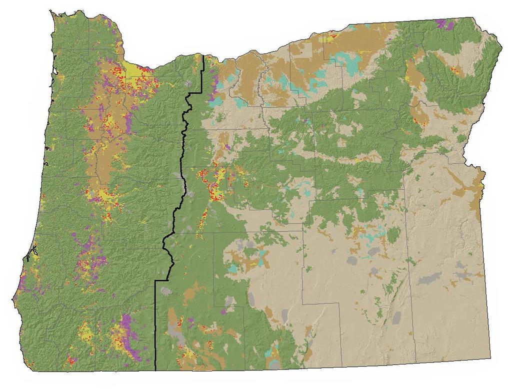
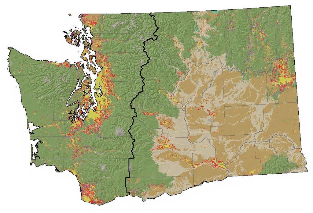
14 Current Land Use (Oregon 2014, Washington 2013)

15 Land Use Change (Oregon , Washington )
16 Non-Federal Land Remaining in Resource Uses (Oregon , Washington ) Oregon Washington 100% 95% Percentage of Land Remaining 90% 85% 80% 75%
17 Non-Federal Land Remaining in Resource Uses (Oregon , Washington ) West Side East Side Oregon Washington Oregon Washington 100% 100% 98% 98% Percentage of Land Remaining 96% 94% 92% 90% 88% 86% 84% Percentage of Land Remaining 96% 94% 92% 90% 88% 86% 84% 82% 82% 80% %
18 Non-Federal Land Remaining in Wildland Forest Use (Oregon , Washington ) Oregon Washington 100% 95% Percentage of Land Remaining 90% 85% 80% 75%
19 Change in Area of Non-Federal Land in Wildland Forest Use, By Owner Type (Oregon , Washington ) Forest industry Other private Non-Federal public All non-federal owners Change, in percent Oregon 0% -7% -1% -2% Western Oregon 0% -10% -1% -3% Eastern Oregon 0% -4% 0% -1% Washington -1% -11% -1% -5% Western Washington -1% -24% -1% -7% Eastern Washington -1% -4% -1% -3%
20 Non-Federal Land Remaining in Intensive Agriculture Use (Oregon , Washington ) Oregon Washington 100% 95% Percentage of Land Remaining 90% 85% 80% 75%
21 Average Area of Non-Federal Land Changing from Resource to Developed Uses, per New Resident (Oregon , Washington ) Oregon Washington Acres
22 Non-Federal Land Remaining in Wildland Forest Use with Less Than 10 Residents per Square Mile (Oregon , Washington ) Oregon Washington 100% 98% 96% Percentage of Land Remaining 94% 92% 90% 88% 86% 84% 82% 80%
23 Structures per Square Mile on Non-Federal Land in Resource Uses, Oregon
24 Structures per Square Mile on Non-Federal Land in Wildland Forest Use, by Ownership Class, Oregon
25 New Structures on Private Land in Wildland Forest Use, by Distance to More Developed Uses, Oregon
26 Net Average Annual Conversion of Private Land from Resource Uses to More Developed Uses, Before and After Implementation of Land Use Plans 0.18% 0.16% Oregon Washington Net Average Annual Loss of Privately- Owned Resource Land (percent) 0.14% 0.12% 0.10% 0.08% 0.06% 0.04% 0.02% 0.00%
27 Net Average Annual Conversion of Private Land from Resource Uses to More Developed Uses, Before and After the Great Recession 0.18% 0.16% Oregon Washington Net Average Annual Loss of Privately- Owned Resource Land (percent) 0.14% 0.12% 0.10% 0.08% 0.06% 0.04% 0.02% 0.00%
28 Ongoing Work: Land Use and Water Quality 100% 90% 80% 70% 60% 50% 40% 30% 20% 10% 0% Sample Points within Forested Land Use Sample Points within Non-Forested Land Use Excellent Good Fair Poor Very Poor Average Oregon Water Quality Index Condition (Water Year 2014)
29 Where to Find More Information Forests, Farms and People: Land Use Change on Non-Federal Land in Oregon, (Lettman et al., 2016) Available at: Changes in Land Use and Housing on Resource Lands in Washington State, (Gray et al., 2013) Available at: Coming soon: Land Use Change on Non-Federal Land in Oregon and Washington: 2017 Update Contact: Dan Hubner,
Participation. Workers Compensation Insurance Seminar. May 22, Nick Beleiciks
 Oregon s Falling Labor Force Participation Workers Compensation Insurance Seminar May 22, 2013 Nick Beleiciks Let s start with a simple graph. Oregon Employment Loss by Recession 0% % Job Loss from Peak
ADOT Statewide Bicycle and Pedestrian Program Summary of Phase IV Activities APPENDIX B PEDESTRIAN DEMAND INDEX
 ADOT Statewide Bicycle and Pedestrian Program Summary of Activities APPENDIX B PEDESTRIAN DEMAND INDEX May 24, 2009 Pedestrian Demand Index for State Highway Facilities Revised: May 29, 2007 Introduction
The Blue Heron Slough Conservation Bank
 1 The Blue Heron Slough Conservation Bank CONSERVATION BANKING July 19-23, 2010 CASE STUDY SERIES The Blue Heron Slough Conservation Bank (Washington) I. OVERVIEW & BACKGROUND: Location: Snohomish River
Deer Management Unit 255
 Deer Management Unit 255 Area Description DMU 255 is located primarily in northern Menominee County, but also extends into a small portion of Dickinson, Marquette, and Delta counties. It has totaled 463
Deer Management Unit 252
 Deer Management Unit 252 Geographic Location: Deer Management Unit (DMU) 252 is 297 miles 2 in size and is primarily in southeastern Marquette, southwestern Alger and northwestern Delta County. This DMU
How Policy Drives Mode Choice in Children s Transportation to School
 How Policy Drives Mode Choice in Children s Transportation to School Physical Activity through Active Transportation Ruth L. Steiner 2011 Technical Conference and Exhibit Lake Buena Vista, FL April 3-6,
DMU 005 Antrim County Deer Management Unit
 DMU 005 Antrim County Deer Management Unit Area Description Antrim County Deer Management Unit is in the Northern Lower Peninsula Region (NLP). It has roughly 74 square miles (47,451 acres) of public land
Deer Management Unit 122
 Deer Management Unit 122 Area Description DMU 122 is located in south Dickinson County and includes a small portion of west central Menominee County. It encompasses 163 sq. miles and has remained unchanged
Northwest Parkland-Prairie Deer Goal Setting Block G7 Landowner and Hunter Survey Results
 Northwest Parkland-Prairie Deer Goal Setting Block G7 Landowner and Hunter Survey Results Table of Contents Public Surveys for Deer Goal Setting... 1 Methods... 1 Hunter Survey... 2 Demographics... 2 Population
Florida Seagrass Integrated Mapping and Monitoring Program
 Florida Seagrass Integrated Mapping and Monitoring Program - 2004 The following document is composed of excerpts taken from the 2011 publication, Seagrass Integrated Mapping and Monitoring for the State
Big Game Survey Results
 Big Game Survey Results - 2017 Surveys Conducted The following big game aerial surveys were flown in 2017: Moose o Game Hunting Areas 13 and 13A (Porcupine Mountain area Western Region) o Game Hunting
Sport Fishing Expenditures and Economic Impacts on Public Lands in Oregon
 Sport Fishing Expenditures and Economic Impacts on Public Lands in Oregon For: Northwest Sportfishing Industry Association By: Southwick Associates October 2013 PO Box 6435 Fernandina Beach, FL32035 Tel
Deer Management Unit 249
 Deer Management Unit 249 Geographic Location: DMU 249 lies along the Lake Michigan shoreline and is comprised largely of Mackinac and Chippewa counties with a small portion of southeastern Luce County
2015 Florida Black Bear Hunt Summary Report
 2015 Florida Black Bear Hunt Summary Report The Florida Fish and Wildlife Conservation Commission (FWC) opened 4 of the 7 bear management units (BMU) in Florida (Figure 1) to bear hunting on Oct. 24, 2015.
SOUTH CAROLINA ELECTRIC & GAS COMPANY COLUMBIA, SOUTH CAROLINA
 SOUTH CAROLINA ELECTRIC & GAS COMPANY COLUMBIA, SOUTH CAROLINA SALUDA HYDROELECTRIC PROJECT (FERC NO. 516) BOATING DENSITY STUDY PLAN FINAL SEPTEMBER 2006 Prepared by: SOUTH CAROLINA ELECTRIC & GAS COMPANY
Managing Chesapeake Bay s Land Use, Fish Habitat, and Fisheries: Studies. Jim Uphoff & Margaret McGinty, Fisheries Service
 Managing Chesapeake Bay s Land Use, Fish Habitat, and Fisheries: Positive Image and or Negative Graphic Case Studies Jim Uphoff & Margaret McGinty, Fisheries Service Maryland Fisheries Service has been
REPORT OF THE ENGINEERING & PLANNING DEPARTMENT PLANNING DIVISION
 REPORT OF THE ENGINEERING & PLANNING DEPARTMENT PLANNING DIVISION 2008 09 22 TO: Mayor John Rowswell and Members of City Council SUBJECT: Official Plan Review 2008 Part 1 - Population and Household Projections
Demographic and Economic Trends in the Tri-State Region
 Demographic and Economic Trends in the Tri-State Region James Gillard FEDERAL RESERVE BANK OF PHILADELPHIA Talk Outline Demographic Trends in the Region Economic Trends in the Region Regional Resources
Tulsa Metropolitan Area LONG RANGE TRANSPORTATION PLAN
 Tulsa Metropolitan Area LONG RANGE TRANSPORTATION PLAN Indian Nations Council of Governments August 2005 CONTACTING INCOG In developing the Destination 2030 Long Range Transportation Plan, INCOG s Transportation
5/DMU 069 Otsego County Deer Management Unit
 5/DMU 069 Otsego County Deer Management Unit Area Description The Otsego County Deer Management Unit (DMU 069) is in the Northern Lower Peninsula Region (NLP). It has roughly 159 Square miles (101,800
Evan Johnson, Tindale Oliver & Associates. Alan Danaher, P.E., PTOE, AICP, PTP
 To: Copies: From: Evan Johnson, Tindale Oliver & Associates Matt Muller, RTS Jesus Gomez, RTS Alan Danaher, P.E., PTOE, AICP, PTP Date: January 14, 2014 Subject: Ridership Projections Gainesville Streetcar
Deer Management Unit 152
 Deer Management Unit 152 Geographic Location: Deer Management Unit (DMU) 152 is 386 miles 2 in size and is primarily in southwestern Marquette County. This DMU falls within the moderate snowfall zone and
DMU 057 Missaukee County Deer Management Unit
 DMU 057 Missaukee County Deer Management Unit Area Description Missaukee County Deer Management Unit is in the Northern Lower Peninsula Region (NLP). It has over 100,000 acres of state land, just over
DMU 024 Emmet County Deer Management Unit
 DMU 024 Emmet County Deer Management Unit Area Description Emmet County Deer Management Unit is in the Northern Lower Peninsula Region (NLP). It has roughly 126 square miles (80,371 acres) of public land
Introduction to Pennsylvania s Deer Management Program. Christopher S. Rosenberry Deer and Elk Section Bureau of Wildlife Management
 Introduction to Pennsylvania s Deer Management Program Christopher S. Rosenberry Deer and Elk Section Bureau of Wildlife Management To anyone who has carefully studied the situation it is evident that
Accounting for Growth: Policy Implications for the Partnership
 Accounting for Growth: Policy Implications for the Partnership Chesapeake Bay Commission September 8, 2017 Rich Batiuk Associate Director for Science, Analysis and Implementation Chesapeake Bay Program
DMU 006 Arenac County Deer Management Unit
 DMU 006 Arenac County Deer Management Unit Area Description The Arenac County Deer Management Unit (DMU) 006 is in the Northern Lower Peninsula (NLP) Region. It has roughly 248,320 acres and consists of
Minnesota Deer Population Goals
 This document is made available electronically by the Minnesota Legislative Reference Library as part of an ongoing digital archiving project. http://www.leg.state.mn.us/lrl/lrl.asp Minnesota Deer Population
Deer Management Unit 349
 Deer Management Unit 349 Geographic Location: DMU 349 lies along the lake Michigan shoreline and is largely comprised of western Mackinac county with small portions of southern Luce county and southeastern
Central Hills Prairie Deer Goal Setting Block G9 Landowner and Hunter Survey Results
 Central Hills Prairie Deer Goal Setting Block G9 Landowner and Hunter Survey Results Table of Contents Public Surveys for Deer Goal Setting... 1 Methods... 1 Hunter Survey... 2 Demographics... 2 Population
Guidelines for Providing Access to Public Transportation Stations APPENDIX C TRANSIT STATION ACCESS PLANNING TOOL INSTRUCTIONS
 APPENDIX C TRANSIT STATION ACCESS PLANNING TOOL INSTRUCTIONS Transit Station Access Planning Tool Instructions Page C-1 Revised Final Report September 2011 TRANSIT STATION ACCESS PLANNING TOOL INSTRUCTIONS
Minnesota Deer Population Goals. Sand Plain Big Woods Goal Block
 Minnesota Deer Population Goals Sand Plain Big Woods Goal Block Minnesota DNR Section of Wildlife, 2015 Final Deer Population Goals Block 5: Sand Plain Big Woods The following pages provide a description
2019 Annual Recalculation and Reappraisal Setup Studies for All Residential Properties in Columbia County for Property Tax Assessment
 2019 Annual Recalculation and Reappraisal Setup Studies for All Residential Properties in Columbia County for Property Tax Assessment Published by the Columbia County Assessor January 2, 2019 Table of
Teton County Related Hunting and Fishing Spending, For the Wyoming Wildlife Federation. David T. Taylor & Thomas Foulke
 Teton County Related Hunting and Fishing Spending, 2015 For the Wyoming Wildlife Federation University of Wyoming, Department of Agricultural & Applied Economics David T. Taylor & Thomas Foulke 1 February
DMU 008 Barry County Deer Management Unit
 DMU 8 Barry County Deer Management Unit Area Description The Barry County Deer Management Unit (DMU) 8 is in the Southwest Region and was once part of the Bellevue deer management unit 38. Bellevue DMU
2010 Wildlife Management Unit 501 moose and deer
 2010 Wildlife Management Unit 501 moose and deer Section Authors: Barb Maile and Velma Hudson Suggested Citation: Maile, B., and V. Hudson. 2010. Wildlife Management Unit 501 moose and deer. Pages 73 77.
Arterial Management Plan for US Route 250 and State Route 623
 Arterial Management Plan for US Route 250 and State Route 623 June 25, 2014 Brad Shelton, AICP Access Management and Traffic Impact Analysis Programs Manager Transportation and Mobility Planning Division
Pedestrian Demand Modeling: Evaluating Pedestrian Risk Exposures
 Pedestrian Demand Modeling: Evaluating Pedestrian Risk Exposures Kelly J. Clifton National Center for Smart Growth University of Maryland May 19, 2008 Study Team University of Maryland National Center
DMU 452 Northern Multi-County Deer Management Unit
 DMU 452 Northern Multi-County Deer Management Unit Area Description The Core TB Zone Deer Management Unit is in the Northern Lower Peninsula Region (NLP) and covers portions of Alcona, Alpena, Montmorency,
Rochester Area Bike Sharing Program Study
 roc bike share Rochester Area Bike Sharing Program Study Executive Summary ~ January 2015 JANUARY 2015 8484 Georgia Avenue, Suite 800 Silver Spring, MD 20910 3495 Winton Pl., Bldg E, Suite 110 Rochester,
Cleve Gaddis Gaddis Partners, RE/MAX Center & USA Management
 Cleve Gaddis Gaddis Partners, RE/MAX Center & USA Management (a boutique residential property management company) 10475 Medlock Bridge Road, Suite 119 Johns Creek, GA 30097 www. 770-497-0000 All information
Agenda Item Summary BACKGROUND. Public Involvement ISSUE ANALYSIS. Attachment 1
 Agenda Item Summary Attachment BACKGROUND Between 996 and 03 white sturgeon fisheries in the Columbia River downstream from Bonneville Dam were managed under a series of management accords between the
Kentucky s Surface Transportation System
 Kentucky s Surface Transportation System ROAD AND BRIDGE CONDITIONS, TRAFFIC SAFETY, TRAVEL TRENDS, AND NEEDS MARCH 2018 PREPARED BY WWW.TRIPNET.ORG Founded in 1971, TRIP of Washington, DC, is a nonprofit
White-tailed Deer Age Report from the Deer Harvest
 White-tailed Deer Age Report from the 2016 Deer Harvest The Vermont Fish and Wildlife Department has made a concerted effort, beginning in 2015, to increase the amount of age data collected from harvested
Summary report on all harvested species on Patuxent Research Refuge from September 1 - January 31, 2017 Deer Harvest
 Patuxent Research Refuge Harvest Report 2016-2017 1 Summary report on all harvested species on Patuxent Research Refuge from September 1 - January 31, 2017 Deer Harvest Central Tract Compound Crossboloader
Rural Ontario s Hidden Sector: The Economic Importance of the Horse Industry Final Report
 Rural Ontario s Hidden Sector: The Economic Importance of the Horse Industry Final Report - 2009 Photo Credit: J.W. Wilton Dr. Bronwynne Wilton and Dr. Wayne Caldwell University of Guelph 1 Executive Summary
MINNESOTA GROUSE AND HARES, John Erb, Forest Wildlife Populations and Research Group DNR, Grand Rapids, MN 55744
 MINNESOTA GROUSE AND HARES, John Erb, Forest Wildlife Populations and Research Group DNR, Grand Rapids, MN 557 RUFFED GROUSE. Minnesota s 55 th annual ruffed grouse drumming survey was conducted during
Note: You do not need to be a Wisconsin landowner; we ll consider any woodland owner in the Midwest region.
 COVERTS COOPERATOR APPLICATION for the 2018 Wisconsin Coverts Project Workshop at Kemp Natural Resources Station in Woodruff, WI August 16-19, 2018 We re looking for private landowners who are interested
2017 DEER HUNTING FORECAST
 2017 DEER HUNTING FORECAST Region 7 Region 7 is located in Central New York, occupying a nine-county area reaching from Lake Ontario to the Pennsylvania border. This region is comprised of two broad ecological
The Role and Economic Importance of Private Lands in Providing Habitat for Wyoming s Big Game
 March 2004 B-1150 The Role and Economic Importance of Private Lands in Providing Habitat for Wyoming s Big Game By Roger Coupal, Department of Agricultural and Applied Economics; Gary Beauvais, Wyoming
Progress Table GreenStep HIA Best Practices
 Executive Summary The HIA will guide the City of Marshall and the GreenStep Committee in prioritizing its involvement in the Minnesota GreenStep Cities Program to advance best practices that leverage improving
METHODOLOGY. Signalized Intersection Average Control Delay (sec/veh)
") Chapter 5 Traffic Analysis 5.1 SUMMARY US /West 6 th Street assumes a unique role in the Lawrence Douglas County transportation system. This principal arterial street currently conveys commuter traffic
Chapter 5 Traffic Analysis 5.1 SUMMARY US /West 6 th Street assumes a unique role in the Lawrence Douglas County transportation system. This principal arterial street currently conveys commuter traffic
LAKE BLUFF PARK DISTRICT BLAIR PARK SWIMMING POOL Questions and Answers OVERVIEW
 LAKE BLUFF PARK DISTRICT BLAIR PARK SWIMMING POOL Questions and Answers www.lakebluffparks.org OVERVIEW Q: How did the community rate the pool on the Community Wide survey? A: The top three highest rated
Regional Planning & Tracking our Progress: Lessons from the Highlands
 Regional Planning & Tracking our Progress: Lessons from the Highlands New Jersey Highlands Water Protection and Planning Council Christine Danis, PP, AICP Director of Planning and Science 5 th Annual Sustainable
11 th Annual Oregon Economic Forum!
 11 th Annual Oregon Economic Forum! (almost) Beyond! Macroeconomics Portland, OR! October 16, 2014! Expansion Continues! Five Years and More!! Recession Indicators Nonfarm Payrolls Real Personal Income
Mill Creek/Rose Valley Watershed General Information Presented by Dr. Mel Zimmerman Lycoming College CWI
 Mill Creek/Rose Valley Watershed General Information Watershed Concerns Rose Valley Lake Areas of Interest Biodiversity of Interest in Rose Valley Lake Rose Valley Lake Bird Area Fishes of Rose Valley
DMU 082 Wayne County Deer Management Unit
 DMU 082 Wayne County Deer Management Unit Area Description The Wayne Deer Management Unit (DMU 082) lies in the Southeast Region and borders Lake Erie to the East and includes Celeron and Stony Islands
TRAFFIC IMPACT STUDY COMPREHENSIVE UPDATE TOWN OF THOMPSON S STATION, TENNESSEE PREPARED FOR: THE TOWN OF THOMPSON S STATION
 TRAFFIC IMPACT STUDY COMPREHENSIVE UPDATE TOWN OF THOMPSON S STATION, TENNESSEE PREPARED FOR: THE TOWN OF THOMPSON S STATION Transportation Consultants, LLC 1101 17 TH AVENUE SOUTH NASHVILLE, TN 37212
Northwest Economic Research Center College of Urban and Public Affairs Forecast Breakfast Economic Outlook
 Northwest Economic Research Center College of Urban and Public Affairs 2019 Forecast Breakfast Economic Outlook 1/10/2019 2 U.S. ECONOMY 1/10/2019 3 1980 1982 1984 1986 1988 1990 1992 1994 1996 1998 2000
DMU 053 Mason County Deer Management Unit
 DMU 053 Mason County Deer Management Unit Area Description Mason County Deer Management Unit is in the Northern Lower Peninsula Region (NLP) on the Lake Michigan coast. Only 17% of the land base is public
make people aware of the department s actions for improving the deer population monitoring system,
 Investing in Wisconsin s Whitetails 1 Over the last 60 years, the department has developed a deer herd monitoring and management system that seeks to use the best science and data possible. The deer monitoring
WALKNBIKE DRAFT PLAN NASHVILLE, TENNESSEE EXECUTIVE SUMMARY NASHVILLE, TENNESSEE
 NASHVILLE, TENNESSEE EXECUTIVE SUMMARY Executive Summary A world-class multi-modal transportation system is essential to a vibrant city and better quality of life. -Mayor Barry The WalknBike plan aims
DMU 056 Midland County Deer Management Unit
 DMU 056 Midland County Deer Management Unit Area Description The Midland County Deer Management Unit (DMU) 056 is in the Northern Lower Peninsula (NLP) Region. It has roughly 333, 440 acres and consists
Spatial Patterns / relationships. Model / Predict
 Human Environment Spatial Patterns / relationships Model / Predict 2 3 4 5 6 Comparing Neighborhoods with high Quality of Life & health Overlap matrix NPUs with high NH & NQoL SEC High QoL High Health
Deschutes County Comprehensive Plan
 Deschutes County Comprehensive Plan Table of Contents Preamble, Vision and Use of this Plan iii Chapter1Comprehensive Planning Section 1.1 Introduction... 2 Section 1.2 Community Involvement... 9 Section
Town of Whitby Official Plan Review OVERVIEW
 Town of Whitby Official Plan Review Presentation at Special Meeting of Council Whitby (Municipal Building) November 28 th, 2007 Brooklin (St. Thomas Anglican Church) December 6 th, 2007 OVERVIEW What is
Speed Limits in the Hoddle Grid
 Speed Limits in the Hoddle Grid Recent History of speed limits March 2013 Docs # 7738485 1 Introduction Muncipalities have power to Erect speed limit signs BUT Municipalities DO NOT have the power to approve
Resident Outdoor Recreation for Fremont County, WY July 1999
 UNIVERSITY OF WYOMING 'P.O. Box 3354 Cooperative Extension Service Laramie, WY 82071-3354 College of Agriculture Phone: 307-766-2386 Department of Agricultural and Applied Economics Fax: 307-766-5544 Resident
DMU 073 Saginaw County Deer Management Unit
 Area Description DMU 073 Saginaw County Deer Management Unit The Saginaw County Deer Management Unit (DMU 073) is located in the Southern Lower Peninsula in the Saginaw Bay region of Wildlife Division
Traffic Impact Analysis Walton Acres at Riverwood Athletic Club Clayton, NC
 Traffic Impact Analysis Walton Acres at Riverwood Athletic Club Clayton, NC 1. TABLE OF CONTENTS INTRODUCTION...1 1.1. Site Location and Study Area...1 1.2. Proposed Land Use and Site Access...2 1.3.
Perspectives of a State Director Selective fisheries as a tool in fisheries management and salmon recovery
 Perspectives of a State Director Selective fisheries as a tool in fisheries management and salmon recovery Jeffrey P. Koenings, PhD. Washington Department of Fish and Wildlife American Fisheries Society
PUBLIC OPINION STRATEGIES
 PUBLIC OPINION STRATEGIES National Association of REALTORS The key findings from a national survey of 1,000 adults conducted October 5, 7, 9-10, 2007. 07574 Methodology Public Opinion Strategies is pleased
AUDIT U.S. FISH AND WILDLIFE SERVICE WILDLIFE AND SPORT FISH RESTORATION PROGRAM GRANTS
 AUDIT U.S. FISH AND WILDLIFE SERVICE WILDLIFE AND SPORT FISH RESTORATION PROGRAM GRANTS Awarded to the State of Wisconsin, Department of Natural Resources, From July 1, 2007, Through June 30, 2009 Report
Sport Fishing Expenditures and Economic Impacts on Public Lands in Washington
 Sport Fishing Expenditures and Economic Impacts on Public Lands in Washington For: Northwest Sportfishing Industry Association By: Southwick Associates Released June 2015 PO Box 6435 Fernandina Beach,
tattersall park RBY EBSCO RETAIL PROPERTIES
 tattersall park EBSCO PROPERTIES RBY RETAIL the case for tattersall park... The 75-acre site OWNED by the developer (EBSCO) has a unique history. It is one of the most attractive multi use sites in the
July 24, Kalispel Tribe of Indians Update on Efforts to Suppress Northern Pike and Policy Implications
 Joan M. Dukes Chair Oregon Bruce A. Measure Montana James A. Yost Idaho W. Bill Booth Idaho Rhonda Whiting Vice-Chair Montana Bill Bradbury Oregon Tom Karier Washington Phil Rockefeller Washington July
2009 Master Plan & Reexamination Report Verona, New Jersey
 2009 Master Plan & Reexamination Report Verona, New Jersey MASTER PLAN TOWNSHIP OF VERONA, NEW JERSEY PREPARED FOR THE PLANNING BOARD OF THE TOWNSHIP OF VERONA, NJ PREPARED BY KASLER ASSOCIATES, PA 34
CORRESPONDENCE/MEMORANDUM
 CORRESPONDENCE/MEMORANDUM State of Wisconsin DATE: November 13, 2012 FILE REF: [Click here and type file ref.] TO: FROM: Mike Donofrio Harpt Lake File Steve Hogler SUBJECT: 2012 Harpt Lake Electrofishing
DMU 045 Leelanau County Deer Management Unit
 DMU 045 Leelanau County Deer Management Unit Area Description The Leelanau County Deer Management Unit (DMU 045) is in the Northern Lower Peninsula Region (NLP). It has roughly 7,100 acres of State Forest
RANDWICK CITY COUNCIL Residential Discussion Paper SUMMARY DOCUMENT
 RANDWICK CITY COUNCIL Residential Discussion Paper SUMMARY DOCUMENT Residential Discussion Paper Summary Sheet Background Randwick City Council is reviewing our local planning and development controls
Outmigration and the Changing Economy of the Great Plains
 Outmigration and the Changing Economy of the Great Plains Presented by: Michael Hayden, Secretary of the Kansas Department of Wildlife and Parks The Great Plains 98 th Meridian 1 2 Percentage Change in
DMU 047 Livingston County Deer Management Unit
 DMU 047 Livingston County Deer Management Unit Area Description The Livingston Deer Management Unit (DMU) lies in the Southern Lower Peninsula (SLP) region and covers only Livingston County. Most public
INDIANA UTILITY DEMAND & RATES FORECAST
 INDIANA UTILITY DEMAND & RATES FORECAST Presented to: Solar Energy Applications for Agriculture Workshop Rochester, IN Presented by: Douglas Gotham November 12, 2014 1 Highlights 2013 forecast growth is
CITY OF COCOA BEACH 2025 COMPREHENSIVE PLAN. Section VIII Mobility Element Goals, Objectives, and Policies
 CITY OF COCOA BEACH 2025 COMPREHENSIVE PLAN Section VIII Mobility Element Goals, Objectives, and Policies Adopted August 6, 2015 by Ordinance No. 1591 VIII MOBILITY ELEMENT Table of Contents Page Number
Performance Measure Summary - San Jose CA. Performance Measures and Definition of Terms
 Performance Measure Summary - San Jose CA There are several inventory and performance measures listed in the pages of this Urban Area Report for the years from 1982 to 2014. There is no single performance
Performance Measure Summary - Chicago IL-IN. Performance Measures and Definition of Terms
 Performance Measure Summary - Chicago IL-IN There are several inventory and performance measures listed in the pages of this Urban Area Report for the years from 1982 to 2014. There is no single performance
Performance Measure Summary - Denver-Aurora CO. Performance Measures and Definition of Terms
 Performance Measure Summary - Denver-Aurora CO There are several inventory and performance measures listed in the pages of this Urban Area Report for the years from 1982 to 2014. There is no single performance
REMOVE BARRIERS TO, ENCOURAGE CREATION OF AND PROVIDE GUIDELINES FOR SAFE ROUTES (ALL DISTRICTS)
") Ordinance 2009-98 AN ORDINANCE OF THE BOARD OF SUPERVISORS OF PIMA COUNTY, ARIZONA; RELATING TO ZONING; AMENDING THE PIMA COUNTY ZONING CODE TITLE 18 BY AMENDING SECTION 18.03.020 (DEFINITIONS) TO ADD
Ordinance 2009-98 AN ORDINANCE OF THE BOARD OF SUPERVISORS OF PIMA COUNTY, ARIZONA; RELATING TO ZONING; AMENDING THE PIMA COUNTY ZONING CODE TITLE 18 BY AMENDING SECTION 18.03.020 (DEFINITIONS) TO ADD
Colorado Economic Update
 Colorado Economic Update Steamboat Economic Summit Place cover image here Brian Lewandowski Associate Director, Business Research Division October 21, 2016 Recession 8 Months Recession 18 Months Real GDP
Know Your River Conwy Salmon & Sea Trout Catchment Summary
 Know Your River Conwy Salmon & Sea Trout Catchment Summary Introduction This report describes the status of the salmon and sea trout populations in the Conwy catchment. Bringing together data from rod
SMART 1 Public Meeting #1. February 24, 2016
 SMART 1 Public Meeting #1 February 24, 2016 Agenda Who is the SMTC? SMART 1 project overview Syracuse Metropolitan Transportation Council An Introduction: Who we are & what we do What is an MPO? A Metropolitan
2005 Arkansas Nongame Wildlife Conservation Survey
 2005 Arkansas Nongame Wildlife Conservation Survey by Survey Research Center Institute of Government University of Arkansas at Little Rock 2801 South University Avenue Little Rock Arkansas 72204 501.569.8561
ROCKWALL CENTRAL APPRAISAL DISTRICT
 ROCKWALL CENTRAL APPRAISAL DISTRICT WILDLIFE MANAGEMENT SPECIAL VALUATION GUIDELINES A SUPPLEMENT TO THE STATE OF TEXAS GUIDELINES FOR QUALIFICATION OF AG LAND IN WILDLIFE MANAGEMENT USE These guidelines
DMU 038 Jackson County
 DMU 038 Jackson County Area Description The Jackson Deer Management Unit (DMU), or DMU 038, lies in the Southern Lower Peninsula (SLP) region and covers Jackson County. The DMU consists of five percent
TECHNICAL MEMORANDUM 3: EXISTING CONDITIONS ANALYSIS FOR THE VILLAGE GREEN MULTIMODAL TRANSPORTATION DISTRICT
 TECHNICAL MEMORANDUM 3: EXISTING CONDITIONS ANALYSIS FOR THE VILLAGE GREEN MULTIMODAL TRANSPORTATION DISTRICT Prepared for: TREASURE COAST REGIONAL PLANNING COUNCIL Prepared by: RENAISSANCE PLANNING GROUP
Monitoring Population Trends of White-tailed Deer in Minnesota Marrett Grund, Farmland Wildlife Populations and Research Group
 Monitoring Population Trends of White-tailed Deer in Minnesota - 2014 Marrett Grund, Farmland Wildlife Populations and Research Group INTRODUCTION White-tailed deer (Odocoileus virginianus) represent one
Traffic Impact Study. Westlake Elementary School Westlake, Ohio. TMS Engineers, Inc. June 5, 2017
 TMS Engineers, Inc. Traffic Impact Study Westlake Elementary School Westlake, Ohio June 5, 2017 Prepared for: Westlake City Schools - Board of Education 27200 Hilliard Boulevard Westlake, OH 44145 TRAFFIC
NEVADA DEPARTMENT OF WILDLIFE STATEWIDE FISHERIES MANAGEMENT FEDERAL AID JOB PROGRESS REPORTS F EUREKA COUNTY Small Lakes and Reservoirs
 NEVADA DEPARTMENT OF WILDLIFE STATEWIDE FISHERIES MANAGEMENT FEDERAL AID JOB PROGRESS REPORTS F-20-48 2012 EUREKA COUNTY Small Lakes and Reservoirs NEVADA DEPARTMENT OF WILDLIFE, FISHERIES DIVISION ANNUAL
The Impact of TennCare: A Survey of Recipients 2006
 The Impact of TennCare: A Survey of Recipients 2006 Brad Kiser Research Associate, Center for Business and Economic Research William F. Fox Director, Center for Business and Economic Research and Professor
Stronghold Investment Partnership Basin Liaisons 2009
 Harry Hoogesteger, Elk River harry.hoogesteger@oacd.org Harry graduated from Lewis and Clark College in Portland, Oregon. His background includes work on a ranch and farm; interpretive writing for the