NSC Cross Country Course
|
|
|
- Alison Megan Casey
- 5 years ago
- Views:
Transcription


1 NSC Cross Country Course Feasibility Report and Design Proposal Proposal for the development of a world class cross country course on the National Sports Campus, Blanchardstown, a course unique in character and amenity, providing an exciting challenge for athletes in training and in competition, capable of attracting and hosting national and international competitions, providing all of the requisite facilities for athletes and their support teams, spectators and media covering competitions at the venue. DRAFT REPORT September 2014
 Landscape Architects and Town Planners and Tobin Consulting Engineers were appointed by the National Sports Campus Development Authority to investigate")

2 NSC Cross Country Course Feasibility Report and Design Proposal 1.0 Introduction Cunnane Stratton Reynolds (CSR) Landscape Architects and Town Planners and Tobin Consulting Engineers were appointed by the National Sports Campus Development Authority to investigate the feasibility of developing a world class cross country training and competition facility in the grounds of Abbotstown House on the National Sports Campus, and to prepare a design proposal for the course. This Report presents the findings of the feasibility study and a proposed course masterplan, to inform costing and ultimately development of the facility. The report contains an analysis of the design principles and technical requirements of a cross country course (Section 2.0), an analysis of the Abbotstown House landscape in terms of its suitability for development of a course (Section 3.0), and a proposed course masterplan (Section 4). Appendix 1 contains a preliminary cost estimate for development of the facility. The Vision Development of a world class cross country course on the National Sports Campus, a course unique in character and amenity and providing an exciting challenge for athletes in training and in competition, capable of attracting and hosting national and international competitions, providing all of the requisite facilities for athletes and their support teams, spectators and media covering major competitions at the venue. 1

3 2.0 Cross Country Course Design Principles The following course design principles are derived from the International Association of Athletics Federations (IAAF) publication Competition Rules Section IX, and from a number of other sources including advice received from Athletics Ireland. 2.1 The Course The course must be designed on an open or woodland area, covered as far as possible with grass, with natural obstacles which can be used by the course designer to build a challenging and interesting race course. The area must be large enough to accommodate not only the course but also the ancillary facilities for competition days. A loop course must be designed, with the loop measuring between 1750m and 2000m. If necessary a small loop can be added in order to adjust to the required distances of various events. IAAF World Cross-Country Championships Distances Men 12km Junior Men 8km Women 8km Junior Women 6km School and other junior races are usually over a distance of 2.5 or 5km. For training purposes, and for variety when hosting competitions, a cross country facility should ideally provide additional courses or loops (additional to the main competition course) where space permits. Each long loop should have a total ascent of at least 10m. Apart from the start and finish areas, the course should be 5-6m wide, including the obstacle areas. In races where there are large numbers of athletes, narrow gaps or other hindrances which would deny athletes an unhampered run shall be avoided for the first 1500m. Existing natural obstacles shall be used if possible. However, very high obstacles should be avoided, as should deep ditches, dangerous ascents/descents, thick undergrowth and, in general, any obstacle which would constitute a difficulty beyond the aim of the competition (i.e. would not support continuous running). It is preferable that artificial obstacles should not be used. Apart from the start and finish areas, the course must not contain any other long straight. A natural, undulating course with smooth curves and short straights, is the most suitable


4 The Lavern Gibson course in Terre Haure, Indiana and a newly developed course at Stromlo Forest Park, Canberra, Australia, are among a small number of dedicated cross country facilities worldwide. These have been developed with the objective of attracting major competitions. The crossing of roads or any kind of macadamised surfaces shall be avoided or at least kept to a minimum. When it is impossible to avoid such conditions in one or two areas of the course, the areas must be covered by grass, earth or mats. The course should begin with a starting arc of up to 40m width, narrowing over the length of a 200m straight 2 (minimum, before the first bend) to the loop course width of 5-6m. The course should end with a finishing straight of 200m, leading into a funneled area that keeps athletes in single-file in order of finish. 3 2 International course design advice suggests a starting straight of 400m. The lands available at Abbotstown House do not allow for the provision of a 400m straight and Athletics Ireland advised that a starting straight of 200m is sufficient.


 space behind the starting line for runners to gather before approaching the starting line.")
, sponsors and media parking area (catering for large vehicles) and equipment storage area.")
5 2.2 Ancillary Facilities In addition to the course, a venue catering for major cross country competitions should have a range of spaces set aside for the provision of temporary facilities for runners and teams, race/event officials and the media, and spectators. These include: Runners and Race Facilities/Space Runners and teams parking area (catering for busses). Runners and teams camp: Toilets, showers and changing facilities, medical tent, food and drink stalls, team areas/tents for privacy, shelter from the weather, equipment storage, etc. A warm-up and warm-down area: A field with suitable surface and sufficient space for runners to do stretching, short runs, etc. A pre-start area: An enclosed (temporarily fenced) space behind the starting line for runners to gather before approaching the starting line. A finish area: A space into which runners are channeled from the finish line, before dispersing after a race. Officials and Media Facilities/Space Officials (race/event organisers), sponsors and media parking area (catering for large vehicles) and equipment storage area. Officials and media logistics area: Toilets, office space (tents), equipment storage area, announcer s desk, etc. Camera positions. Spectators Facilities/Space Spectator parking area. Spectator facilities: Toilets, sponsors tents, food and drink stalls, etc. Track-side spectator space (external to the track). Spectator areas internal to the course. 4

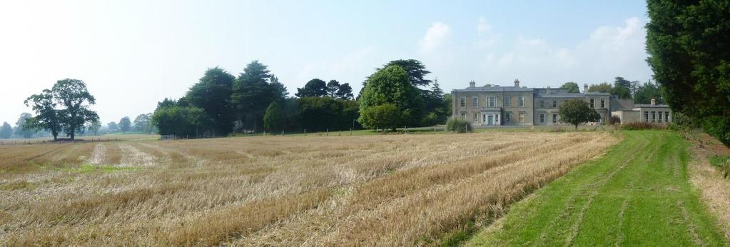
6 3.0 Abbotstown House Landscape Analysis Suitability for a Cross Country Course The lands available for development include a number of large fields to the south west, south and east of Abbotstown House, between the house and the woodland buffer alongside the M50 motorway. These lands were part of the historic Abbotstown Demesne and elements of the designed demesne landscape remain. N Abbotstown House Graveyard West field South field Eastern fields South west field M50 Approximate area available for development of the course 3.1 Opportunities The fields to the west, south west and south of Abbotstown house are undulating, with low hills and sweeping, shallow valleys. Within and around the large fields, currently used for tillage farming, there are patches of woodland and a large number of majestic specimen trees. The topography and vegetation provide framed views of the house, with few detractors to visual amenity. There is an old walled graveyard to the south of the house, containing the ruins of a church and enclosed by mature trees. Two disused and overgrown roads running along ancient townland boundaries converge adjacent to the graveyard, at an old demesne gateway marked by stone pillars. The roads are enclosed on one side by tall, stone demesne walls. 5


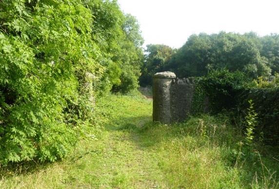
7 Ergrwetgr5rrrrrrrrrrrrrrrrrrrrrrrrrrrrrrrrrrrrrrrrrrrrrrrrrrrrrrrrrrrrrrrrrrrrrrrrrrrrrrrrrrrrrrrrrrrrrrrrrrrrrrrrrrrrrrrrrrr rrr The fields to the south and south west of Abbotstown House are undulating and feature a framework of woodland and a large number of specimen trees. 6 The historic demesne gatepost beside the graveyard, and a view along the old road alongside the demesne wall, now blocked by debris and overgrown.


8 3.2 Constraints The M50 passing to the south and east of the lands is entirely screened from view by a belt of maturing woodland. However the noise of traffic is constant in its vicinity and it will be required that parts of the course run close to the motorway boundary. Beyond the fields to the east of Abbotstown House the large, unsightly buildings of the Ballycoolin industrial estate are visible. One of the eastern fields is traversed by an overhead power line, supported by a combination of steel and timber pylons. The landform of the eastern fields is relatively flat and there is less enclosing vegetation, resulting in a perception of greater exposure to the surrounding detractors (the industrial estate and the motorway). This area is of lesser value from the perspective of runners, spectators and media. 3.3 Summary The lands to the south west and south of Abbotstown House lend themselves perfectly to the provision of a competition cross country course. The topography, vegetation and built heritage features can be harnessed to create a challenging and exciting course for runners in a landscape of high amenity value for spectators and the media. (The field to the west of the house also has significant potential, but this area is reserved for alternative future development.) It is possible to accommodate a 2km loop in the south west and southern fields, with various options for shorter internal loops to create courses of different length. Concentrating development in this area would avoid use of the more exposed fields to the east, thus limiting the effects of the detracting elements in the environment. Additional loops could be accommodated in the eastern area (and/or in the very attractive western field, even temporarily), possibly forming part of the wider suite of running circuits provided on the NSC. There is sufficient space and existing infrastructure in the vicinity of Abbotstown House (access, parking, services, etc.) to accommodate the ancillary facilities associated with major competitions. In addition to these site attributes the NSC has a wide range of complementary sports facilities that would add value to a cross country facility, and the campus benefits from excellent national and international accessibility. 7
9 4.0 Proposed Cross Country Course Masterplan A proposed cross country competition course is presented on Plan A overleaf. Plan B on the following page shows the possible spatial arrangement around Abbotstown House of the key of the ancillary facilities required for major race events. The key elements of the course are described in the following pages. (The course could be run clockwise or anticlockwise for training or for lesser events. For major race days it is envisioned that it will be run clockwise. The course sections/features are described in clockwise order.) 8

10
11
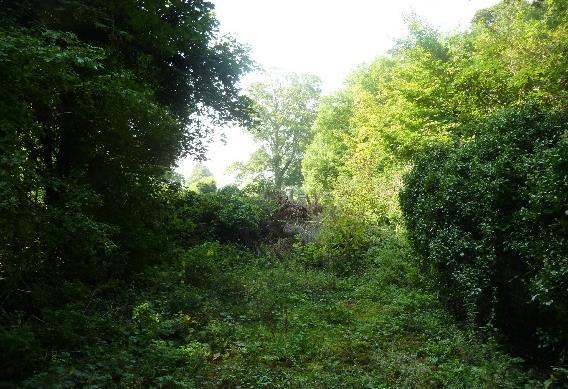
12 4.1 Proposed Course Description Start/Finish Area It is proposed to locate the start and finish straights in the field directly to the south of Abbotstown House. The field is spacious enough to accommodate two 200m straights, and these can be aligned so that the house provides a dramatic backdrop for spectators and camera positions. There is sufficient space to accommodate the requisite temporary runners and teams, officials and media facilities in the vicinity of the house, as well as large numbers of spectators in the field itself. This area is accessible by road and close to the other services such as electricity and water available at the house. A camera position and spectator space in the centre of the field would allow views of the start and finish straights with the house as a backdrop, and allow them to turn around to see a section of the loop to the south. Development of this area would require the entire field to be cultivated, and start and finish straights regularly mowed and delineated by temporary fencing for race days. The Upper Field At the end of a 200m straight the course narrows to 6m wide and rounds an existing patch of woodland. At this point runners would disappear from the start/finish camera position and spectators. Rounding the bend the course dips into a shallow valley between the woodland patch and another cluster of mature trees, passing the 500m mark, then curves around a low hill towards the new planted woodland buffer along the M50. A camera position on the low hill would capture the runners emerging from the first bend, racing down the valley and curving into the woodland. It would also capture runners existing the woodland path (see below) further along the course. Development of this section requires cultivation of the course (levelling, grass seeding) and regular mowing of the track, as well as levelling of a buffer area both sides of the track for spectators. M50 Woodland Section It is proposed to clear a path through the established, semi-mature woodland that forms a buffer between the M50 and the Abbotstown House lands. The course through this woodland climbs over the side of a pronounced hill, then descends and curves to meet the old road. This section would be largely hidden from view of fixed camera positions and spectators. It would provide an element of excitement for runners, and anticipation for spectators. The Old Road The course passes through a new gap in the old demesne wall to access the old road running alongside it. The road is enclosed by the wall on one side and the M50 woodland buffer on the other. It runs straight for a distance of approximately 150m towards an old demesne gateway beside the graveyard, where it bends sharply running alongside the graveyard wall. The track then turns out of the old road up a new ramp and out of the woodland buffer to emerge in the south western field. 9 The Old Road section will be a unique cross country course feature, providing heritage interest and atmosphere to the course as well as excitement with the runners being enclosed for a stretch between the demesne wall and the
13 woods. Revealing and making use of the built heritage features will also improve their condition which is deteriorating as they become increasingly overgrown. Development of this section will require the creation of two new gateways in the demesne walls, and building a ramp out of the sunken roadway up into the south west field. Since the roads are surfaced in coarse old tarmac, it will be necessary to cover them with a layer of sand, which will need to be temporarily replenished to counteract erosion. The Lower Field Emerging from the ramp out of the Old Road the course curves through a sloping field and takes a wide bend around a stand of trees at the far end of the field (it is proposed to supplement these trees with additional woodland planting). It then curves back up the field between two groups of mature trees before a short steep climb past the graveyard towards the woodland path. A camera position and spectator area in the centre of the field would provide a good view of runners emerging from the Old Road and covering the stretch of some 700m through the field. Development of this area would require the track and a spectator buffer either side of the track to be cultivated and regularly mowed. The Woodland Path The course passes by the graveyard (which it is proposed would be cleared of scrub to reveal the enclosing wall, the church ruins and the gravestones) and enters an existing narrow path 100m long between two woodland patches, where the canopies of the trees merge to form a green tunnel. It may be necessary to widen the path by clearing some semi-mature trees on either side to achieve 5-6m width. The Upper Field Emerging from the woodland the course climbs then dips over a hill, then curves up the field towards Abbotstown House before rounding a large woodland patch in the middle of the field to run parallel with the starting straight and then meet the starting straight at the 2km mark. This this completes the main course loop. On the final lap of a race, on exiting the Woodland Path the track diverts from the loop onto the finishing straight which runs straight up the hill to end in front of Abbotstown House. 10
14 Appendix 1 Development Cost Estimate 11
15
DESIGN CODE. Enterprise West Harlow London Road North Design Code 21
 DESIGN CODE Enterprise West Essex @ Harlow London Road North Design Code 21 4 MAXIMUM BUILDING HEIGHTS 4.1 Table 4A sets out maximum building height standards for each character area within the LDO boundary.
FOCUS AREA 1 - Alberta Avenue Pocket Park 3 (121 Ave and 92 St)
") FOCUS AREA 1 - Alberta Avenue Pocket Park 3 (121 Ave and 92 St) New benches Plant evergreen trees Widen existing sidewalk from 1.5m to 1.8m Marked crosswalk 1.8m wide sidewalk Add pedestrian oriented lights
FOCUS AREA 1 - Alberta Avenue Pocket Park 3 (121 Ave and 92 St) New benches Plant evergreen trees Widen existing sidewalk from 1.5m to 1.8m Marked crosswalk 1.8m wide sidewalk Add pedestrian oriented lights
Review of Guidelines for Cycleway Safety Fencing
 Review of Guidelines for Cycleway 1.0 PURPOSE 1.1 This document is meant to provide a review of available reference documents for determining appropriate fencing requirements for cycleway paths and shared
Cross Country and Road Running Guidelines
 Cross Country and Road Running Guidelines SECTION 1: GENERAL These guidelines are intended to give a lead to Centres and Clubs conducting Cross Country and Road Races for children. These events shall be
Executive Summary Route 30 Corridor Master Plan
 Route Corridor Master Plan Project Overview The Route Corridor Master Plan is a coordinated multimodal transportation and land use plan for the entire stretch of Route through East Whiteland Township,
Support Infrastructure
 GUIDANCE NOTE 06 Support Infrastructure 96 COMMUNITY CRICKET FACILITY GUIDELINES VERSION SEPTEMBER 2015 SECTION 2 Guidance Note 06 Support Infrastructure INTRODUCTION Outside of the main playing, training
APPENDIX 11 WIND EFFECTS ASSESSMENT
 APPENDIX 11 WIND EFFECTS ASSESSMENT Summerset Villages (Lower Hutt) Ltd District Plan Change Request Prepared by Urban Perspectives Ltd 17 September 2014 341 49 342 Opus Research Report 14-529D84.00 Wind
NATIONAL ROAD 3: KEEVERSFONTEIN TO WARDEN (DE BEERS PASS SECTION) CHAPTER 3: DESCRIPTION OF THE PROJECT
 CHAPTER 3: DESCRIPTION OF THE PROJECT") NATIONAL ROAD 3: KEEVERSFONTEIN TO WARDEN (DE BEERS PASS SECTION) CHAPTER 3: DESCRIPTION OF THE PROJECT 3. DESCRIPTION OF THE PROJECT This Chapter presents a description of the De Beers Pass Route (DBPR)
NATIONAL ROAD 3: KEEVERSFONTEIN TO WARDEN (DE BEERS PASS SECTION) CHAPTER 3: DESCRIPTION OF THE PROJECT 3. DESCRIPTION OF THE PROJECT This Chapter presents a description of the De Beers Pass Route (DBPR)
Appendix B - Street Sections
 Appendix B - Street Sections 6TH STREET CORRIDOR PLAN STREET SECTIONS The street sections in Appendix B include recommended improvements to streets for North Glenwood. They include existing conditions
Montgomery County Life Sciences Center Loop Trail
 Montgomery County Life Sciences Center Loop Trail Advisory Committee Meeting #1 February 10, 2015 Agenda 1. Project Background 2. Existing Conditions Analysis 3. Examples from Elsewhere 4. Discussion Project
11.2 Detailed Checklists CHECKLIST 1: FEASIBILITY STAGE AUDIT. 1.1 General topics Scope of project; function; traffic mix
 11.2 Detailed Checklists CHECKLIST 1: FEASIBILITY STAGE AUDIT 1.1 General topics 1.1.1 Scope of project; function; traffic mix What is the intended function of the scheme? Is the design consistent with
Tonight is for you. Learn everything you can. Share all your ideas.
 Strathcona Neighbourhood Renewal Draft Concept Design Tonight is for you. Learn everything you can. Share all your ideas. What is Neighbourhood Renewal? Creating a design with you for your neighbourhood.
Part B Design Guidance / Principles _
 Part B Design Guidance / Principles www. landlab.co.nz Queenstown Town Centre Public Realm Design Guidelines Version 7 14 June 2018 Page 006 B1 Design Guidance & Best Practice The Queenstown Town Centre
Lee s Summit Road Improvement Study Public Open House June 7, 2007 Summary of Comment Card Responses
 Lee s Summit Road Improvement Study Public Open House June 7, 2007 Summary of Comment Card Responses Introduction At the Lee s Summit Road Improvement Study Public Open House held Thursday, June 7, 2007
AWBOP Winter Events Risk Plan April 2016
 AWBOP Winter Events Risk Plan April 2016 1. EVENT FACILITIES 1.1 Traffic Approach Routes Consideration must be given to how traffic should approach the venue. Checks should be made to avoid possible conflicts
Road Safety Audit training course. Motorways - safety issues of the motorway design
 Road Safety Audit training course Motorways - safety issues of the motorway design Jesper Mertner, Road safety auditor, COWI A/S 1 ROAD SAFETY AUDITING COURSE Content 1. Safety 2. Cross sections 3. Horizontal
Hopkins Architects. University of Nottingham. University Park Campus Masterplan Strategy. 13 th February 2009
 University of Nottingham University Park Campus Masterplan Strategy 13 th February 2009 Purpose of this Document The purpose of this document is to set out a new masterplan strategy for University Park
Make Lincoln Highway an economically vibrant corridor that is safe, efficient, and beautiful for local residents and visitors.
 Lincoln Highway Streetscape Plan Stakeholder Workshop #2 Handout Contents Introduction and Project Vision Planning Principles Specific Recommendations including a Proposed Typical Roadway Section Renderings
Transit boulevard: A new road type for Sydney s Growth Centres
 Transit boulevard: A new road type for Sydney s Growth Centres Cleaver, M. A., de Roos, M. P., NSW Centre for Road Safety, Roads and Traffic Authority, NSW Collins, G., Network Services, Roads and Traffic
Off-road Trails. Guidance
 Off-road Trails Off-road trails are shared use paths located on an independent alignment that provide two-way travel for people walking, bicycling, and other non-motorized users. Trails specifically along
Heartwood Forest, in Sandridge, Hertfordshire, is a place where everyone can find space, peace, wildlife and miles of beautiful woodland to explore.
 Heartwood Forest Accessibility Statement September 2016 Purpose: This accessibility statement outlines the available facilities and access information for Heartwood Forest. Welcome We, the Woodland Trust,
Tech Guide: 25th Annual Cycle-Smart International Technical Guide Saturday, November 7th and Sunday, November 8th, 2015
 Tech Guide: 25th Annual Cycle-Smart International Technical Guide Saturday, November 7th and Sunday, November 8th, 2015 Look Park, Northampton, MA Verge New England Cyclo-cross Series presented by Stan's
Works Approval Application. G.2 Traffic
 Works Approval Application G.2 Traffic RO097400.WAA.23.04.2018 Floor 11, 452 Flinders Street Melbourne VIC 3000 PO Box 312, Flinders Lane Melbourne VIC 8009 Australia T +61 3 8668 3000 F +61 3 8668 3001
Chapter 3 DESIGN SPECIFICATIONS
 Brampton PathWays Planning and Design Guidelines 27 Chapter 3 DESIGN SPECIFICATIONS 3.1 CLASS 1 MULTI-USE PATH Off-road multi-use trails are the backbone of the Brampton PathWays Network. They are typically
Footpath design. A guide to creating footpaths that are safe, comfortable, and easy to use
 Footpath design A guide to creating footpaths that are safe, comfortable, and easy to use November 2013 Contents Introduction / 1 Zoning system / 2 Width / 4 Height / 5 Surface / 5 Footpath elements /
Lincoln Highway Streetscape Plan Concept Plan
 Lincoln Highway Streetscape Plan Concept Plan November 14, 2014 Introduction This report provides a summary of conceptual transportation, land use, and design recommendations in the Lincoln Highway Streetscape
01. VICINITY OF GREENBRAE POC: EXISTING CONDITIONS
 01. VICINITY OF GREENBRAE POC: EXISTING CONDITIONS Existing Bus Stop Existing US101 On-ramp Existing POC Old Redwood Highway Rich Street City ROW Environmental Study Limit Industrial Way NO DESIGNATED
Multi-Modal Traffic Analysis. Parisi and Associates
 Mill Valley to Corte Madera Bicycle and Pedestrian Corridor Study Appendix D: Multi-Modal Traffic Analysis Prepared by Parisi and Associates August 2009 Appendix D - Multi-Modal Traffic Analysis Table
Frome Street Bicycle Route
 The Adelaide City Council invites engagement from the community about Frome Street Bicycle Route Project Summary Adelaide City Council is seeking feedback on design options to construct bicycle facilities
Red Rocks Pari-whero. Red Rocks/Pari-Whero. Quarry. Owhiro Bay Quarry. Owhiro Bay Parade. Taputeranga Marine Reserve ISSUES AND OPPORTUNITIES ANALYSIS
 Red Rocks Pari-whero Wild coastal environment Shared path with WD vehicles Red Rocks/Pari-Whero Owhiro Bay Parade Owhiro Bay Quarry Quarry Taputeranga Marine Reserve 2 PART Potential future links Makara
APPENDIX 2 LAKESHORE ROAD TRANSPORTATION REVIEW STUDY EXECUTIVE SUMMARY
 APPENDIX 2 LAKESHORE ROAD TRANSPORTATION REVIEW STUDY EXECUTIVE SUMMARY Appendix 2 City of Mississauga Lakeshore Road FINAL REPORT Transportation Review Study December 2010 EXECUTIVE SUMMARY Study Purpose
LOCAL CIRCUIT EM1: EAST MALLING & BARMING HEATH. N 2m ROADS: Significant roads PATHS: Starting direction Barming Longsole Mission Church
 Ditton Church Scott Close LOCAL CIRCUIT EM1: EAST MALLING & BARMING HEATH 6 Community Centre F Open fields (see 'Introductory Notes') 1m 88 Direction label (as in the walk notes) East Malling Church -
NETTLESTEAD & YALDING
 NETTLESTEAD & YALDING ULL CIRCUIT - Sheet 1 (first and last sections) Open fields (see 'Introductory Notes') 88 Direction label (as in the walk notes) ROADS: 81 10m Significant roads Redhill arm North
18.1 Introduction Maintaining pedestrian-related Problems arising in the long term. infrastructure
 18 Maintaining the pedestrian network Maintaining the pedestrian network Maintenance in the short and long term Planning for pedestrians during maintenance works 18.1 Introduction Both pedestrian-related
Irish National Cyclo-cross Championships 2016 Technical Guide (v4)
") Irish National Cyclo-cross Championships 2016 Technical Guide (v4) This is the technical guide to the 2016 Irish National Cyclo-cross Championships which will be hosted by Dromara Cycling Club at Tollymore
Irish National Cyclo-cross Championships 2016 Technical Guide (v4) This is the technical guide to the 2016 Irish National Cyclo-cross Championships which will be hosted by Dromara Cycling Club at Tollymore
ROUTE 81 CORRIDOR STUDY DESIGN CONCEPTS
 RT 81 Corridor Study CLINTON ROUTE 81 CORRIDOR STUDY DESIGN CONCEPTS View north on High Street, with potential improvements to the streetscape Draft Recommendations November 8 th, 2018 TOWN OF CLINTON
Chapter 4 Cyclo-cross
 Chapter 4 Cyclo-cross 110 4. Cyclo-cross Racing 4A. Course and obstacles 4A1. The course shall be held over varying terrain including roads, country or forest paths, and open terrain alternating in such
CROSS COURSE INSTRUCTION DOCUMENT
 CROSS COURSE INSTRUCTION DOCUMENT Table of Contents CROSS COURSE DESCRIPTION... 3! CRITERIA FOR SBX/SX RUN SELECTION... 4! Gradients / Slope inclinations... 4! Run Width... 4! Level of Courses... 8! Beginner
DUNDONALD LINKS CLUBHOUSE
 DUNDONALD LINKS CLUBHOUSE Members Update Document October 2015 6-8 Cole Street, Studio 11, SE1 4YH London CONTENTS PAGE 1.0 INTRODUCTION 1.1 Summary 3 1.2 Client 3 1.3 Design Team 3 2.0 APPRAISAL 2.1 Location
ALBERTA AVENUE WHAT WE HEARD REPORT BUILDING GREAT NEIGHBOURHOODS
 ALBERTA AVENUE WHAT WE HEARD REPORT BUILDING GREAT NEIGHBOURHOODS FEBRUARY 2019 EXECUTIVE SUMMARY Starting in 2019, Alberta Avenue will see the replacement and enhancement of its aging collector and local
Bicycle and Pedestrian Facilities Toolbox (Excerpt from Figure 3.1)
") Appendix B Neighborhood Connections Summaries This Appendix is a supplement to the information presented in Chapter 3 Connect People. The Appendix includes a summary or profile for each of the proposed
Appendix B Neighborhood Connections Summaries This Appendix is a supplement to the information presented in Chapter 3 Connect People. The Appendix includes a summary or profile for each of the proposed
BMX Track Guide. Developing the Sport of BMX Racing
 BMX Track Guide Developing the Sport of BMX Racing Contents Introduction... 2 Version in Force... 2 How to Use this Guide... 3 Developing the Sport of BMX Racing... 3 Preparing to Build the BMX Track...
RILLINGTON TO MALTON by Tania Dickinson
 RILLINGTON TO MALTON by Tania Dickinson This walk takes you from the Vale of Pickering up on to the Wold scarp, before dropping down again through the pretty village of Settrington and joining the Centenary
Appendix C. TRAFFIC CALMING PROGRAM TOOLBOX
 Appendix C. TRAFFIC CALMING PROGRAM TOOLBOX PHASE I...2 Do Not Enter Sign...3 One-Way Sign...4 Turn Prohibition...5 Pavement Markings...6 Speed Monitoring Trailer...7 Neighborhood Speed Watch...8 Police
Town of Mooresville, North Carolina Neighborhood Traffic Calming and Control Device Policy
 Town of Mooresville, North Carolina Neighborhood Traffic Calming and Control Device Policy Adopted January 6, 2014 Town of Mooresville Development Services Department TOWN OF MOORESVILLE NEIGHBORHOOD TRAFFIC
CONNECTIVITY PLAN. Adopted December 5, 2017 City of Virginia Beach
 CONNECTIVITY PLAN Adopted December 5, 2017 City of Virginia Beach CONTENTS 1.0 Background & Purpose... 2 2.0 Existing Inventory & Analysis... 3 ViBe District Existing Walking Conditions... 4 3.0 ViBe District
ATHLETE GUIDE 15 SEPTEMBER 2018
 ATHLETE GUIDE 15 SEPTEMBER 2018 1. GENERAL INFORMATION British Triathlon would like to extend a warm welcome to all competitors, coaches, team managers and spectators to Mallory Park. The event plays host
This report provides an overview of all the feedback received, key themes which emerged and the actions Grenadier will take in response.
 Executive Summary During October 2017, Grenadier held three well attended public consultation events at Ocean in Exmouth. In addition, a bespoke consultation website was created to allow for online feedback,
General Design Factors
 Chapter 3: 3-1.0 Introduction General Design Factors Mn/DOT s goals include encouraging and accommodating safe bicycling. From a design perspective, these goals are achieved by first having an understanding
STONY PLAIN ROAD STREETSCAPE
 Jasper Place Revitalization Strategy: Vision The people involved in the Jasper Place Revitalization Strategy envision: Goal 1: Feeling safe in our community Create a community where feeling safe is common--where
Neighborhood Analysis & Improvement Ideas. El Montevideo Neighborhood
 Neighborhood Analysis & Improvement Ideas El Montevideo Neighborhood El Montevideo Neighborhood Neighborhood Analysis & Improvement Ideas Drachman Institute College of Architecture and Landscape Architecture
City centre parklands UEFA disruption Q & A sheet v1:
 Questions & Answers: The things you need to know about how city centre parkland will be affected by Cardiff s hosting of the UEFA Champions League Finals The men s UEFA Champions League Final will take
Technical note. 1. Introduction
 Project: A428 study - Phase 2 To: Adrian Shepherd Subject: Park & Ride site locations From: Atkins Date: Jun 3, 2016 cc: Ashley Heller 1. Introduction 1.1. Purpose of Technical Note The purpose of this
MARLWOOD GOLF & COUNTRY CLUB WASAGA BEACH, ONTARIO
 MARLWOOD GOLF & COUNTRY CLUB WASAGA BEACH, ONTARIO Prepared for: Marlwood Golf & Country Club 445 Golf Course Road Wasaga Beach, Ontario L0L 2P0 Prepared by: MBTW Golf Design 255 Wicksteed Avenue Unit
2018 ALL SCHOOLS CROSS COUNTRY CHAMPIONSHIP
 SCHOOL SPORT WA 2018 ALL SCHOOLS CROSS COUNTRY CHAMPIONSHIP Friday 18 May 2018 UWA Sports Park McGillivray Rd, Mt Claremont TABLE OF CONTENTS 1. Acknowledgements... 1 2. Introduction... 2 3. Carnival Procedures....
CHECKLIST 2: PRELIMINARY DESIGN STAGE AUDIT
 CHECKLIST 2: PRELIMINARY DESIGN STAGE AUDIT 2.1 General topics 2.1.1 Changes since previous audit Do the conditions for which the scheme was originally designed still apply? (for example, no changes to
This walk description is from happyhiker.co.uk
 This walk description is from happyhiker.co.uk Pendle Hill Walk From Barley Starting point and OS Grid reference Ordnance Survey map Distance Traffic light rating Barley village honesty box car park OS
SECTION 12 ROAD MARKINGS AND DELINEATION
 SECTION 12 ROAD MARKINGS AND DELINEATION (Blank Page) MANUAL OF TRAFFIC SIGNS AND MARKINGS - Part III: Motorways and Expressways 12-1 12.1 GENERAL 12.1.1 INTRODUCTION The markings and delineation details
10 Miles Circular 5 hours
 VISIT RYEDALE PICKERING AND CAWTHORN CAMPS 10 Miles Circular 5 hours Moderate Terrain 120616 A 10 mile (16km) there and back walk from the market town of Pickering in Ryedale. The route heads north through
EXECUTIVE SUMMARY Callan Park accommodates travel from a wide range of transport modes, including walking, cycling, bus and light rail.
 TRANSPORT AND ACCESS EXECUTIVE SUMMARY Callan Park accommodates travel from a wide range of transport modes, including walking, cycling, bus and light rail. Whilst there are some walking facilities within
MOTOCROSS CIRCUIT SAFETY GUIDELINES
 MOTOCROSS CIRCUIT SAFETY GUIDELINES Issue #3 OCTOBER 2012 1. The MCFederation Motocross Circuit Guidelines will be used to conduct course inspections prior to the issue of a Course Certificate and are
section 4 Existing Conditions, Issues, and Options
 section 4 Existing Conditions, Issues, and Options 4.0 Existing Conditions, Issues, and Options This section analyzes each segment of the corridor on a street to street basis. Each segment is discussed
Figure 4-10: Pedestrian Improvements Types of Potential Station Area Improvements - Place-Making Improvements
 INCORPORATE FEATURE PAVIN IN CROSSWALK AND INTERSECTION FIELDS Identifies high-priority pedestrian areas and create a station identity through colorful and interesting patterns ADD CURB EXTENSIONS Extending
Campbell Drive to Snapper Point
 Campbell Drive to Snapper Point 1 hr 45 mins 4.2 km One way Experienced only 135m This walk follows the Coast Track to Frazer Beach, along the Geebung and (overgrown) Grass Tree Tracks. From the northern
Devonport City Cycling Network Strategy
 Devonport City Cycling Network Strategy 2010-2013 Devonport City Cycling Network Strategy Introduction In February 2010 a draft master plan for cycleways was presented to the community. The feedback received
NEW TOWN RETAIL PRECINCT UPGRADE
 The City of Hobart is seeking feedback from the community on the streetscape concept for the New Town Retail Precinct upgrade project. The concept designs have been developed by the City of Hobart in response
The Mendip Way. Route Directions and Maps Wells to Frome
 The Mendip Way Route Directions and Maps Wells to Frome Website: www.mendiphillsaonb.org.uk Email: mendip@mendiphillsaonb.org.uk Facebook & Twitter: @MendipHillsAONB Phone: 01761462338 1 Wells to Shepton
NEWLANDS CORNER AND ST MARTHAS
 NEWLANDS CORNER AND ST MARTHAS 10k CIRCULAR ROUTE 2½-3HRS GU4 8SE From Newlands Corner on the North Downs just outside Guildford, you can enjoy one of the most beautiful panoramas of quintessential English
Cliveden Cross Country Sunday 7 January 2018, 9.00am Under UK Athletics Rules SEAA Race Permit
 Cliveden Cross Country Sunday 7 January 2018, 9.00am Under UK Athletics Rules SEAA Race Permit 2018 31623 Welcome to another post-christmas test of endurance and fitness at Cliveden presented by kind permission
ASSOCIATION OF RUNNING CLUBS EVENT PLANNING AND RISK ASSESSMENT
 ASSOCIATION OF RUNNING CLUBS EVENT PLANNING AND RISK ASSESSMENT The purpose of this document is to inform and promote best practice for organisers of ARC permitted races. Consideration of the following
Green Streets and Urban Greenways
 127 11 Green Streets and Urban Greenways 11. Green Streets and Urban Greenways 128 11 Green Streets and Urban Greenways Once the traffic-free section of a route has come to an end, then comes the remaining
Developed by: The American Traffic Safety Services Association (ATSSA) 15 Riverside Parkway, Suite 100 Fredericksburg, VA
 15 Riverside Parkway, Suite 100 Fredericksburg, VA") Addendum Developed by: The American Traffic Safety Services Association (ATSSA) 15 Riverside Parkway, Suite 100 Fredericksburg, VA 22406-1022 800-272-8772 This material is based upon work supported by
Addendum Developed by: The American Traffic Safety Services Association (ATSSA) 15 Riverside Parkway, Suite 100 Fredericksburg, VA 22406-1022 800-272-8772 This material is based upon work supported by
For more information and to buy this book click here ISBN: CICERONE. Guides for walkers, trekkers, mountaineers, climbers and cyclists
 For more information and to buy this book click here ISBN: 9781852845377 CICERONE Guides for walkers, trekkers, mountaineers, climbers and cyclists www.cicerone.co.uk WALK 5 Ouston and Urpeth Distance
Guidance. ATTACHMENT F: Draft Additional Pages for Bicycle Facility Design Toolkit Separated Bike Lanes: Two-Way to One-Way Transitions
 ATTACHMENT F: Draft Additional Pages for Bicycle Facility Design Toolkit Separated Bike Lanes: Two-Way to One-Way Transitions This treatment provides a transition from two-way separated bike lanes to one-way
Highway 56 Traffic Study Rymal Road to Cemetery Road
 January 31, 2018 6:00 pm 8:00 pm Highway 56 Traffic Study Rymal Road to Cemetery Road City of Hamilton Public Meeting 2 2 Purpose of Public Meeting To review and obtain public input and comments on the
PUBLIC REALM MASTER PLAN
 WESTSHORE BUSINESS DISTRICT PUBLIC REALM MASTER PLAN MASTER PLAN COMMITTEE MEETING MARCH 20, 2013 WESTSHORE BUSINESS DISTRCT PUBLIC REALM MASTER PLAN MACRO-SCALE CONCEPT: A PUBLIC REALM FRAMEWORK DEFINED
Midtown Rail Station Accessibility Assessment N4
 Midtown Rail Station Accessibility Assessment N4 Joel Anders, Arnaud Huguet, and Alex Poznanski 15 August 2012 Table of Contents EXECUTIVE SUMMARY... 1 MISSION STATEMENT... 2 INTRODUCTION... 2 CROSSWALKS
City of Elizabeth City Neighborhood Traffic Calming Policy and Guidelines
 City of Elizabeth City Neighborhood Traffic Calming Policy and Guidelines I. Purpose: The City of Elizabeth City is committed to ensure the overall safety and livability of residential neighborhoods. One
Route 47 (North Main Street) Reconstruction
 Reconstruction") TOWN OF SUNDERLAND Route 47 (North Main Street) Reconstruction Presented by Lou Rabito, P.E. Presented to Town of Sunderland June 11, 2018 Project Overview MassDOT Project No. 607245 Resurfacing and Related
TOWN OF SUNDERLAND Route 47 (North Main Street) Reconstruction Presented by Lou Rabito, P.E. Presented to Town of Sunderland June 11, 2018 Project Overview MassDOT Project No. 607245 Resurfacing and Related
Swamp Road Residents Study
 Swamp Road Residents Study SRRG Meeting with PennDot and Elected Officials Newtown and Wrightstown, PA April 25, 2008 Newtown Township Section of Swamp Road Limited Public Funds No reconstruction of a
COMPLETE STREETS PLANNER S PORTFOLIO
 COMPLETE STREETS PLANNER S PORTFOLIO ISSUE 3 APRIL 2016 PLANNER S PORTFOLIO COMPLETE STREETS 1 2 6 10 14 OVERVIEW MATURE NEIGHBORHOODS GROWING SUBURBS CENTRAL PLACES ACTIVITY CORRIDORS Planner s Portfolio
Appendix D Stage 1 Road Safety Audit
 N2 Monaghan Town to Emyvale Road Improvements Part 8 Application Description of Proposed Development Appendi D N2 Monaghan Town to Emyvale, County Monaghan Proposed Pavement and Minor Improvement Scheme
SECTION 12 ROAD MARKINGS AND DELINEATION
 SECTION 12 20 June 2009 Part 3: Motorways and Expressways CONTENTS Reference Page Page Number Date SECTION 12: MARKINGS AND DELINEATION 12.1 GENERAL... 12-1 June 2009 12.1.1 INTRODUCTION... 12-1 June 2009
TRANSPORT AND MOVEMENT
 TRANSPORT AND MOVEMENT Movement Strategy Public Transport Cycling and Walking Road Network Parking Standards Transport Impact Assessments Traffic Management Policies DRAFT POOLBEG PLANNING SCHEME Movement
Active Transportation Rail to River Corridor. Community Meeting - Segment A
 Active Transportation Rail to River Corridor Community Meeting - Segment A June 29, 2017 Tonight s Agenda > Open House (30 min) > Welcome / Project Overview > Presentation of 30% Design Refinements > Next
Technical Memorandum. Subject: Interchange Ramp Terminal Configuration. Expiration. Implementation. Introduction
 Minnesota Department of Transportation Engineering Services Division Technical Memorandum To: Electronic Distribution Recipients From: Nancy T. Daubenberger, P.E. Assistant Commisioner, Engineering Services
The Colosseum Court at Mediterra
 The Colosseum Court at Mediterra 2012 AMERICAN SPORTS BUILDERS ASSOCIATION DISTINGUISHED TENNIS FACILITY 2013 USTA OUTSTANDING TENNIS FACILITY BAUER CONSULTING Tim Bauer, Design / Construction / Management
INTrepid Orienteering Weekend
 INTrepid Orienteering Weekend DECHMONT LAW South of Scotland Orienteering League (SoSOL) 7 Local Event & East of Scotland Orienteering Association (ESOA) Championships Sunday 4 th November 2018 Directions:
La Madre Wilderness Area
 La Madre Wilderness Area Rock Climbing Inventory Statistics: Area: Walls La Madre North 3 24 136 22 Kraft Mt./Gateway Canyon White Rock Springs Willow Springs East The Promised Land 18 4 3 3 12 23 11 24
Coquitlam Cross-town Bike Route Improving Bicycle Facilities in a Mature Suburban Environment
 Coquitlam Cross-town Bike Route Improving Bicycle Facilities in a Mature Suburban Environment Sarah Rocchi, Vice-President, Projects, Opus International Consultants (Main Presenter) Catherine Mohoruk,
Draft. Lecompton. Table of Contents. Background
 Lecompton Table of Contents Existing Infrastructure 80 Funding 82 Policy and Program Recommendations 83 Infrastructure Implementation Scenarios 84 Conclusion 85 Douglas County Lecompton Background Located
Three Springs Design Guidelines Fencing and Wall Standards
 Three Springs Design Guidelines Fencing and Wall Standards Original Adopted: June 12, 2006 Minor Amendment: December 2012 Minor Amendment: March 23, 2017 TABLE OF CONTENTS: FENCING AND WALLS 1.0 INTRODUCTION
Application No: MO/2018/0004 Location: Land at Langley Vale, South of Downs Road and east of Headley Road, Headley, Epsom
 26 February 2018 5 Woodlands Way Ashtead KT21 1LH Telephone: 01372 274925 Email: rbennett@dsl.pipex.com The Chief Planning Officer Mole Valley District Council Pippbrook Dorking Surrey RH14 1SJ Dear Sir,
Cycle traffic and the Strategic Road Network. Sandra Brown, Team Leader, Safer Roads- Design
 Cycle traffic and the Strategic Road Network Sandra Brown, Team Leader, Safer Roads- Design Highways England A Government owned Strategic Highways Company Department for Transport Road Investment Strategy
Memo. Ocean Avenue Corridor Design Project Public Workshop #2 Summary
 Ocean Avenue Corridor Design Project Public Workshop #2 Summary The second public workshop for the Ocean Avenue Corridor Design Project was held on Wednesday, May 14, 2014 from, 6 to 8 pm at Lick Wilmerding
NOT TO SCALE PUBLIC WORKS STANDARD DETAILS CURB DETAILS DATE: MARCH 2013 FILE NAME: CURB.DWG
 NOT TO SCALE PUBLIC WORKS STANDARD DETAILS CURB DETAILS DATE: MARCH 2013 FILE NAME: CURB.DWG NOT TO SCALE PUBLIC WORKS STANDARD DETAILS SIDEWALK RAMPS DATE: MARCH 2013 FILE NAME: SIDEWALK RAMPS.DWG NOT
Grade Separated Intersection
 Grade Separated Intersection Lecture Notes in Transportation Systems Engineering Prof. Tom V. Mathew Contents 1 Overview 1 2 Classification of Intersection 2 2.1 Grade Separated Intersection...........................
AIRPORT ROAD ENVIRONMENTAL ASSESSMENT
 WELCOME TO PUBLIC INFORMATION CENTRE #1 AIRPORT ROAD ENVIRONMENTAL ASSESSMENT From Braydon Boulevard/Stonecrest Drive to Countryside Drive November 23, 2017 6:30 PM 8:30 PM Please sign in and fill out
Alberta Infrastructure HIGHWAY GEOMETRIC DESIGN GUIDE AUGUST 1999
 Alberta Infrastructure HIGHWAY GEOMETRIC DESIGN GUIDE AUGUST 1999,1'(; A ACCELERATION Data on acceleration from stop D-29 Effects of grade D-35 Intersections D-97, D-99 Lanes D-97, F-5, F-7, F-15, F-21,
Newcastle Racecourse Masterplan. 1 Introduction. Completing the vision of a redeveloped Newcastle Racecourse Welcome to our exhibition.
 1 Introduction Completing the vision of a redeveloped Newcastle Racecourse Welcome to our exhibition. Please take a look at our information boards and feel free to ask members of the project team any questions