CRUISE REPORT FOR UW BERING STRAIT MOORING PROJECT 2005 Rebecca Woodgate, University of
|
|
|
- Loraine Scott
- 5 years ago
- Views:
Transcription


1 CRUISE REPORT FOR UW BERING STRAIT MOORING PROJECT 2005 Rebecca Woodgate, University of CCGC Sir Wilfrid Laurier Kodiak, 8 th July 2005 Barrow, 22nd July 2005 Science Coordinator: Bon Van Hardenberg, Institute of Ocean Sciences, Sidney, BC Lead for Canadian Science Team: Ed Carmack, IOS, BC Lead for US Science Team: Jackie Grebmeier, University of Tennessee Overview IOS cruise is part of a on-going Canadian-US collaboration to investigate the ecology and climate of the northern Bering Sea, the Bering Strait and the Chukchi Sea. For full details, see Van Hardenberg/Grebmeier Cruise Report. In 2005, this research cruise also recovered and redeployed 3 moorings in the Bering Strait region, PIs Rebecca Woodgate and Knut Aagaard, University of Washington, and performed a high resolution CTD section across the Bering Strait and medium resolution CTD lines across the Alaskan Coastal Current in the vicinity of mooring A3, Point Hope and Cape Lisburne. The Bering Strait line has been occupied for several years by Canadian and US researchers. The other three lines have been occupied once a year for many years since 2000 under NSF SBI funding. Cruise Participants 1. Bon van Hardenberg (M)-DFO/IOS Chief Scientist 2. Dr. Jackie Grebmeier (F)-U Tennessee, Knoxville, Co-Chief Scientist 3. Dr. Lee Cooper (M)-U Tennessee, Knoxville 4. Dr. Peter Lee (M)-U of Charleston, SC 5. Dr. Rebecca Woodgate (F)-U Washington, Seattle 6. Arianne Balsom (F)-U Tennessee Knoxville 7. Betty Carvellas (F)- Essex High School, Vermont 8. Rebecca Pirtle-Levy (F)-U Tennessee Knoxville 9. William Floering (M)-NOAA/PMEL (Jim Overland, lead) 10. Jeri Lee Butcher (F) DFO/IOS Woodgate 2005 Laurier Mooring report Page1:13 July 2005

2 Cruise Map of Stations relevant to UW Mooring work Map of region most relevant to UW Mooring Project. Green = mooring locations A2, A3 and A4 for recoveries and redeployments. Red = CTD stations taken this cruise. Grey = CTD stations taken in previous years. Note that in 2005, the Bering Strait line was run ca. 2 nm south of the prior UW line and the Point Hope line was run slightly north (7 nm or less) of the prior UW line. CTDs were also taken at mooring positions. Woodgate 2005 Laurier Mooring report Page2:13 July 2005
3 Mooring recovery and redeployment Three physical/ biogeochemical Bering Strait moorings were recovered and redeployed during this cruise. These moorings are part of a multi-year time-series (now 15 years long) of measurements of the flow through the Bering Strait. This flow acts as a drain for the Bering Sea shelf, dominates the Chukchi Sea, influences the Arctic Ocean, and can be traced across the Arctic Ocean to the Fram Strait and beyond. The long-term monitoring of the inflow into the Arctic Ocean via the Bering Strait is important for understanding climatic change both locally and in the Arctic. The last 3 years of data suggest that heat and freshwater fluxes are increasing through the strait - the work completed this summer should tell us if this is a continuing trend. Three moorings (A2 and A4, in the eastern channel of Bering Strait, and A3, ca. 35nm north of Bering Strait), deployed from the Alpha Helix last year, were funded by ONR/NSF (Aagaard and Woodgate, UW, ) and are the final field work for the NSF-SBI program ( The three moorings deployed this year are NSF funded (Woodgate, UW). All the moorings carry conventional instrumentation - current meters (RCM or ADCP), temperature and salinity sensors (SBE16). In addition, moorings A2 and A3 carry Upward-Looking-Sonars (ULS) (Moritz, UW). The mooring A4 carries an upward-looking ADCP (instead of the RCM) to study the coastal jet. In , mooring A3 also supported a transmissometer, a fluorometer and a PAR sensor, connected to the SBE16 (Whitledge and Weingarter, UAF). For the 2005 redeployment, these latter instruments were placed on mooring A2 rather than A3. The redeployed mooring A2 also carries an ISUS nitrate meter (Whitledge, UAF). The current meters and ULSs allow the quantification of the movement of ice and water through the strait. The nutrient sampler, the transmissometer and fluorometer time-series measurements should advance our understanding of the biological systems in the Bering Strait and Chukchi Sea. Maintaining the time-series measurements in Bering is important to several national and international programs, e.g. NSF s Freshwater Initiative (FWI) and Arctic Model Intercomparison Project (AOMIP), and the international Arctic SubArctic Ocean Fluxes (ASOF) program. It also supports regional studies in the area, by providing key boundary conditions for the Chukchi Shelf/Beaufort Sea region; a measure of integrated change in the Bering Sea, and an indicator of the role of Pacific Waters in the Arctic Ocean. Furthermore, the Bering Strait inflow is considered important for the Atlantic overturning circulation and possibly world climate. In , the mooring work is also in collaboration with the RUSALCA project led by John Calder of NOAA in collaboration with AARI, St. Petersburg, who are maintaining moorings in the western channel of the Bering Strait (Whitledge and Weingartner, UAF). Despite rough weather, the three mooring recoveries and redeployments were accomplished in one day. The moorings were ranged on and released from the USCGC Laurier, and a small boat was used to attach a line to the moorings, which was passed to the ship. Since the moorings are short (~ 10m), with the long boom of the Laurier, the entire mooring could be recovered or deployed in one pick, making for very speedy work. All operations went smoothly, due to skilled small boat and deck operations. One acoustic release on A2-04 failed to release on command, but after repositioning the ship, the second release on A2 functioned properly and the mooring was recovered in the usual manner. We are still investigating why the first release on A2 failed to release the mooring. Details of mooring positions and instrumentation and preliminary results are given in the T able and Figures below. Although significant amounts of silt had collected in the mooring floatation, especially at site A4 in the Alaskan Coastal Current, biofouling was only moderate ( see photographic appendix). Although detailed, quantitative analysis is still to be done, the mooring data suggests a warming and freshening especially in the Alaskan Coastal Current. Woodgate 2005 Laurier Mooring report Page3:13 July 2005
4 Bering Strait and Alaska Coastal Current CTD lines Four CTD lines were taken as per the map above. Preliminary results are shown in Figures below. Strong northerly winds preceding and during the mooring work appear to have reduced the strength of the Alaskan Coastal Current, a conclusion supported by data from the recovered ADCP. The strong northward currents frequently encountered in the region were absent for most of the line. Just off Point Hope however, an approximate 3 knot surface current was evident during the CTD section. Note the very fresh, warm waters in the CTD section at this location (~ 18 psu, 12 deg C). (In comparison to the lines further south, the Cape Lisburne line had less fresh water, suggesting either the bulk of the Alaskan Coastal Current had been diverted away from the coast, or that it had not yet arrived from the south. Woodgate 2005 Laurier Mooring report Page4:13 July 2005
5 Table of Bering Strait Mooring Positions and Instrumentation ID LATITUDE (N) LONGITUDE (W) WATER DEPTH /m INST. Recover A ' ' 55 ULS (uc 51) RCM7 SBE16 A ' ' 57 ULS (uc 54) RCM11 SBE/TFP A ' ' 47 ADCP (uc 43) SBE16 Deploy A ' ' 58 ULS (uc 53) RCM7 SBE/TFP ISUS A ' ' 58 ULS (uc 53) RCM11 SBE16 A ' ' 49 ADCP (uc 44) SBE16 ULS = APL Upward Looking Sonar RCM7 = Aanderaa Mechanical Recording Current Meter RCM9 and RCM11 = Aanderaa Acoustic Recording Current Meter SBE16 = Seabird CTD recorder SBE/TFP = Seabird CTD recorder with transmissometer, fluorometer and PAR sensor ISUS= Nutrient Analyzer ADCP = RDI Acoustic Doppler Current Profiler uc = uncorrected for ship's draft (3m for Helix; 5 m for Laurier) Woodgate 2005 Laurier Mooring report Page5:13 July 2005
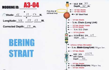
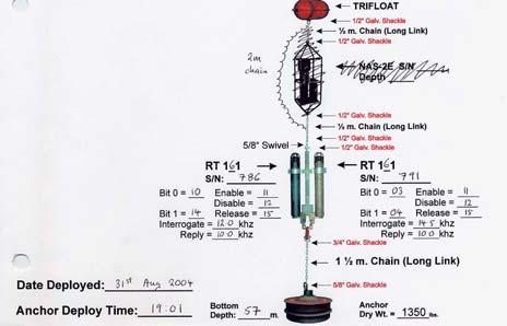
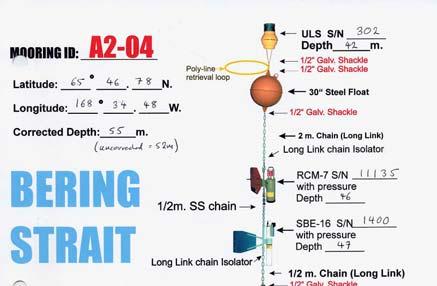
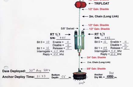
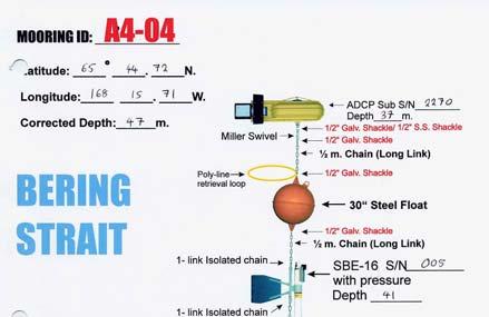
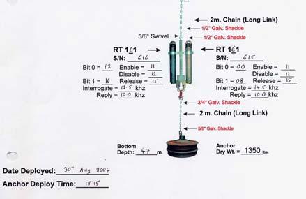
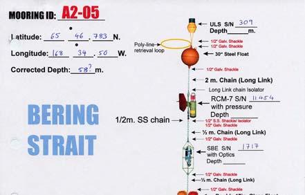
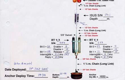
6 Schematics of Mooring Recoveries Woodgate 2005 Laurier Mooring report Page6:13 July 2005
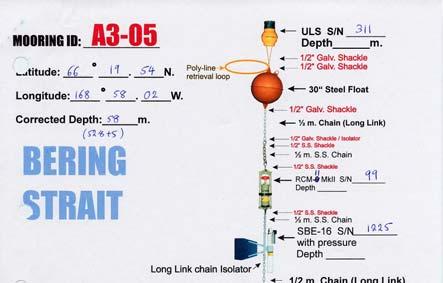
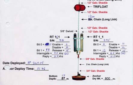
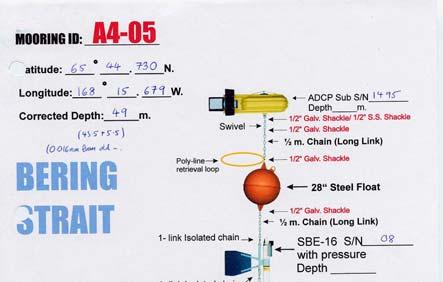
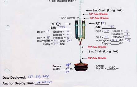
7 Schematics of Mooring Deployments Woodgate 2005 Laurier Mooring report Page7:13 July 2005
8 Preliminary Current Meter Results Woodgate 2005 Laurier Mooring report Page8:13 July 2005

9 Preliminary Seacat Results Woodgate 2005 Laurier Mooring report Page9:13 July 2005
 Woodgate 2005 Laurier Mooring report")
10 Preliminary CTD Sections - BERING STRAIT (ca. 2 nm S of prior location) Woodgate 2005 Laurier Mooring report Page10:13 July 2005
11 Preliminary CTD Sections - A3-L LINE Woodgate 2005 Laurier Mooring report Page11:13 July 2005
 Woodgate 2005 Laurier Mooring report Page12:13")
12 Preliminary CTD Sections - POINT HOPE LINE (7 nm-0 nm N of previous location) Woodgate 2005 Laurier Mooring report Page12:13 July 2005
13 Preliminary CTD Sections - CAPE LISBURNE LINE Woodgate 2005 Laurier Mooring report Page13:13 July 2005
CRUISE REPORT FOR UW/UAF BERING STRAIT MOORING PROJECT 2006 Rebecca Woodgate, University of
 CRUISE REPORT FOR UW/UAF BERING STRAIT MOORING PROJECT 2006 Rebecca Woodgate, University of Washington,woodgate@apl.washington.edu CCGS Sir Wilfrid Laurier SWL2006-01 Victoria, 1 st July 2006 Dutch Harbor,
The Pacific Gateway to the Arctic: Recent change in the Bering Strait - observations, drivings and implications
 The Pacific Gateway to the Arctic: Recent change in the Bering Strait - observations, drivings and implications 1 Rebecca Woodgate, Cecilia Peralta-Ferriz University of Washington, Seattle, USA Recent
Upstream environment for SBI - Modeled and observed biophysical conditions in the northern Bering Sea
 Upstream environment for SBI - Modeled and observed biophysical conditions in the northern Bering Sea Jaclyn Clement 1, Wieslaw Maslowski 1, Lee Cooper 2, Jacqueline Grebmeier 2, Waldemar Walczowski 3,
7.4 Temperature, Salinity and Currents in Jamaica Bay
 7.4 Temperature, Salinity and Currents in Jamaica Bay Arnold Gordon, Bruce Huber and Robert Houghton 7.4.1 INTRODUCTION Jamaica Bay stratification is weakly indicative of a shallow, tidally active environment,
MAPCO2 Buoy Metadata Report Project Title:
 MAPCO2 Buoy Metadata Report Project Title: Autonomous Multi-parameter Measurements from a Drifting Buoy During the SO GasEx Experiment Funding Agency: NOAA Global Carbon Cycle program PI(s): Christopher
Welcome to PolarConnect
 Welcome to PolarConnect with Lisa Seff and the Oceanographic Conditions of Bowhead Whale Habitat 2012 PolarTREC Expedition Friday 7 September 2012 7:15 a.m. AKDT (8:15 am PDT, 9:15 am MDT, 10:15 am CDT,
Observing and interpreting the seasonal variability of the oceanographic fluxes passing through Lancaster Sound of the Canadian Arctic Archipelago
 Observing and interpreting the seasonal variability of the oceanographic fluxes passing through Lancaster Sound of the Canadian Arctic Archipelago Simon Prinsenberg, Jim Hamilton, Ingrid Peterson and Roger
THE CIRCULATION IN THE NORTERN PART OF THE DENMARK STRAIT AND ITS VARIABILITY ABSTRACT
 ICES em 19991L:06 THE CIRCULATION IN THE NORTERN PART OF THE DENMARK STRAIT AND ITS VARIABILITY Steingrimur J6nsson Marine Research Institute and University of Akureyri, Glenirgata 36, 600 Akureyri, Iceland,
RR10106 Cruise Plan ITOP Mooring Recovery and PhilSea10 Seaglider Operation (R/V Revelle November 6-26, 2010)
") RR10106 Cruise Plan ITOP Mooring Recovery and PhilSea10 Seaglider Operation (R/V Revelle November 6-26, 2010) Chief Scientist: Ren-Chieh Lien, Applied Physics Lab, University of Washington Co-Chief Scientist:
RR10106 Cruise Plan ITOP Mooring Recovery and PhilSea10 Seaglider Operation (R/V Revelle November 6-26, 2010) Chief Scientist: Ren-Chieh Lien, Applied Physics Lab, University of Washington Co-Chief Scientist:
R/V Point Sur Pre-Cruise Questionnaire
 R/V Point Sur Pre-Cruise Questionnaire Please fill this out and return at least 40 days prior to your cruise to ensure that all of your technical needs can be met BASIC INFO Purpose of Cruise: Submitter's
Columbia River Plume 2006 OSU Ocean Mixing Nash, Kilcher, Moum et al. CR05 Cruise Report (RISE Pt. Sur, May )
") CR05 Cruise Report (RISE Pt. Sur, May 21-31 2006) Group Summary: Participants: Pt. Sur Ocean Mixing Group: Jonathan Nash, Levi Kilcher, Alexander Perlin, Greg Avicola; Pt. Sur UW: Emily Spahn (Alex Horner-Devine;
CR05 Cruise Report (RISE Pt. Sur, May 21-31 2006) Group Summary: Participants: Pt. Sur Ocean Mixing Group: Jonathan Nash, Levi Kilcher, Alexander Perlin, Greg Avicola; Pt. Sur UW: Emily Spahn (Alex Horner-Devine;
Application for Consent to Conduct Marine Scientific Research. F Internal Waves in Straits (IWISE) Institution Contact Information Director
 Institution Contact Information Director") 1. General Information 1.1 Reference ID: Application for Consent to Conduct Marine Scientific Research Application number: Project name: F2010-111 Internal Waves in Straits (IWISE) 1.2 Sponsoring institution(s):
1. General Information 1.1 Reference ID: Application for Consent to Conduct Marine Scientific Research Application number: Project name: F2010-111 Internal Waves in Straits (IWISE) 1.2 Sponsoring institution(s):
PRELIMINARY CRUISE REPORT, W9909C R/V WECOMA, September 1999 GLOBEC/ENSO Long-Term Observations off Oregon
 Submitted by Jane Fleischbein College of Oceanic & Atmospheric Sciences Oregon State University Corvallis, Oregon 97331-553 flei@oce.orst.edu, 541.737.5698 FILING DATE: 1 October 1999 PRELIMINARY CRUISE
Effect of Ocean Conditions on the Cross-shelf Distribution of Walleye Pollock (Theragra chalcogramma) and Capelin (Mallotus villosus)
 and Capelin (Mallotus villosus)") Effect of Ocean Conditions on the Cross-shelf Distribution of Walleye Pollock (Theragra chalcogramma) and Capelin (Mallotus villosus) Anne Hollowed, Chris Wilson, Phyllis Stabeno, and Libby Logerwell National
Effect of Ocean Conditions on the Cross-shelf Distribution of Walleye Pollock (Theragra chalcogramma) and Capelin (Mallotus villosus) Anne Hollowed, Chris Wilson, Phyllis Stabeno, and Libby Logerwell National
WHOTS Mooring Subsurface Instrumentation
 UH Contributions to WHOTS-13 Cruise Report by Fernando Santiago-Mandujano, Daniel McCoy, Jefrey Snyder, R. Walter Deppe, Kellen Rosburg, Glenn Carter, Katrina Berry, and Roger Lukas WHOTS Mooring Subsurface
Current observations at the Jan Mayen Ridge
 Current observations at the Jan Mayen Ridge Kjell Arne Mork 1, Ken Drinkwater 1, Steingrimur Jónsson 2, Hédinn Valdimarsson 2 1 Institute of Marine Research and Bjerknes Centre for Climate Research, Bergen,
Prince Madog cruise 25/06 POL Coastal Observatory cruise August 2006
 Prince Madog cruise 25/06 POL Coastal Observatory cruise 38 15-16 August 2006 1. Objectives 1. At 53º 32 N 3º 21.8 W, half a mile west of the Mersey Bar Light Vessel (site A) To recover a) A sea bed frame
Thermohaline Front at the Mouth of Ise Bay
 Journal of Oceanography, Vol. 53, pp. 403 to 409. 1997 Short Contribution Thermohaline Front at the Mouth of Ise Bay TETSUO YANAGI 1, XINYU GUO 1, TOSHIRO SAINO 2, TAKASHI ISHIMARU 3 and SINICHIRO NORIKI
RV Southern Surveyor. program. voyagesummaryss02/2010
 2009 RV Southern Surveyor program voyagesummaryss02/2010 SS02/2010 IMOS-Southern Ocean Time Series Facility Voyage period Start: 16/03/2010 End: 22/03/2010 Port of departure: Hobart, Tasmania, Australia
NSF's Ocean Observatories Initiative: Building Research Infrastructure for the Pacific Northwest and the Broader Community
 Agenda Item B.3.b Supplemental OOI PowerPoint April 2013 Ocean Observatories Initiative NSF's Ocean Observatories Initiative: Building Research Infrastructure for the Pacific Northwest and the Broader
WEBB RESEARCH CORPORATION
 Use spacebar or arrow keys to advance slide show WEBB RESEARCH CORPORATION Falmouth, MA APEX Profiler SLOCUM Glider Rev: 06/22/08 WEBB RESEARCH CORPORATION Specialists in neutrally buoyant drifters and
"Real-Time Vertical Temperature, and Velocity Profiles from a Wave Glider"
 DISTRIBUTION STATEMENT A. Approved for public release; distribution is unlimited. "Real-Time Vertical Temperature, and Velocity Profiles from a Wave Glider" Luca Centurioni Scripps Institution of Oceanography
Wave Glider: Liege Colloquium. Colloquium April 27
 The The Wave Wave Glider: Glider: Enabling Enabling aa New New Approach Approach to to Persistent Persistent Ocean Ocean Observation Observation and and Research Research nd Liege 42 42nd Liege Colloquium
Currents measurements in the coast of Montevideo, Uruguay
 Currents measurements in the coast of Montevideo, Uruguay M. Fossati, D. Bellón, E. Lorenzo & I. Piedra-Cueva Fluid Mechanics and Environmental Engineering Institute (IMFIA), School of Engineering, Research
DIVE PLAN Leg 1 Dive 11 Recover Wally 1
 DIVE PLAN Leg 1 Dive 11 Recover Wally 1 Page 1 of 6 Location: Barkley Canyon Date: 9 May, 2014 14:00 Constraints: Weather, Sufficient deck space ROV Dive # OE 114 Objectives Prepare Wally I cable for recovery
Summer water masses and fish communities in the north-western Bering and western Chukchi Seas in
 Summer water masses and fish communities in the north-western Bering and western Chukchi Seas in 2003-2010 Gennady V. Khen 1, Evgeny O. Basyuk 1, Kirill Kivva 2, and Vladimir I. Matveev 1 1 Pacific Research
3 Solutions Found for Irish Research Vessels. A CTD Davit design
 3 Solutions Found for Irish Research Vessels A CTD Davit design A Vibration Damping Solution Managing mooring chain on a small vessel Bill Dwyer, P&O Maritime Services Ltd Celtic Voyager & Celtic Explorer
Observations of Near-Bottom Currents with Low-Cost SeaHorse Tilt Current Meters
 DISTRIBUTION STATEMENT A. Approved for public release; distribution is unlimited. Observations of Near-Bottom Currents with Low-Cost SeaHorse Tilt Current Meters Vitalii A. Sheremet, Principal Investigator
Water circulation in Dabob Bay, Washington: Focus on the exchange flows during the diurnal tide transitions
 Water circulation in Dabob Bay, Washington: Focus on the exchange flows during the diurnal tide transitions Jeong-in Kang School of Oceanography University of Washington (206) 349-7319 nortiumz@u.washington.edu
Pathways of Pacific water across the Chukchi Sea: A numerical model study
 JOURNAL OF GEOPHYSICAL RESEARCH, VOL. 109,, doi:10.1029/2003jc001962, 2004 Pathways of Pacific water across the Chukchi Sea: A numerical model study Peter Winsor and David C. Chapman Physical Oceanography
COMPARISON OF DEEP-WATER ADCP AND NDBC BUOY MEASUREMENTS TO HINDCAST PARAMETERS. William R. Dally and Daniel A. Osiecki
 COMPARISON OF DEEP-WATER ADCP AND NDBC BUOY MEASUREMENTS TO HINDCAST PARAMETERS William R. Dally and Daniel A. Osiecki Surfbreak Engineering Sciences, Inc. 207 Surf Road Melbourne Beach, Florida, 32951
Ocean Currents Lecture Notes
 Ocean Currents Lecture Notes (Topic 9A) page 1 Ocean Currents Lecture Notes Surface Currents Ocean Currents (What is an ocean current? How is a current different from a wave?) The water in an travels from
Cruise Report. Beaufort Sea and Canada Basin CCGS Louis S. St-Laurent 29 July 1 September, 2005
 2005 Joint Western Arctic Circulation Study and Beaufort Gyre Observing System Cruise Report Beaufort Sea and Canada Basin CCGS Louis S. St-Laurent 29 July 1 September, 2005 Institute of Ocean Sciences
Contents. 1. Cruise information Outline of YK17-E KEO buoy mooring work 12. Acknowledgment 19
 Contents 1. Cruise information 2 2. Outline of YK17-E01 4 3. KEO buoy mooring work 12 Acknowledgment 19 1 YK17-E01 Preliminary Cruise Report 1. Cruise information Makio Honda (JAMSTEC) (1) Cruise designation
TRIAXYS Acoustic Doppler Current Profiler Comparison Study
 TRIAXYS Acoustic Doppler Current Profiler Comparison Study By Randolph Kashino, Axys Technologies Inc. Tony Ethier, Axys Technologies Inc. Reo Phillips, Axys Technologies Inc. February 2 Figure 1. Nortek
PROUDMAN OCEANOGRAPHIC LABORATORY CRUISE REPORT NO. 42. ASOF: Inverted Echo Sounders in the Denmark Strait. As part of FS METEOR CRUISE 59/1
 PROUDMAN OCEANOGRAPHIC LABORATORY CRUISE REPORT NO. 42 ASOF: Inverted Echo Sounders in the Denmark Strait As part of FS METEOR CRUISE 59/1 JUNE 27, 2003 JULY 20, 2003 G.W. Hargreaves 2003 DOCUMENT DATA
Fine-Scale Survey of Right and Humpback Whale Prey Abundance and Distribution
 DISTRIBUTION STATEMENT A. Approved for public release; distribution is unlimited. Fine-Scale Survey of Right and Humpback Whale Prey Abundance and Distribution Joseph D. Warren School of Marine and Atmospheric
QC for Hydrographic Data GEOSECS to GO-SHIP. Susan M. Becker Scripps Institution of Oceanography Oceanographic Data Facility
 QC for Hydrographic Data GEOSECS to GO-SHIP Susan M. Becker Scripps Institution of Oceanography Oceanographic Data Facility Global Hydrographic Efforts Geo-chemical Ocean Sections (GEOSECS) World Ocean
Temperature, Salinity, Dissolved Oxygen and Water Masses of Vietnamese Waters
 Southeast Asian Fisheries Development Center Temperature, Salinity, Dissolved Oxygen and Water Masses of Vietnamese Waters Penjan Rojana-anawat, Siriporn Pradit, Natinee Sukramongkol and Somboon Siriraksophon
APPENDIX G WEATHER DATA SELECTED EXTRACTS FROM ENVIRONMENTAL DATA FOR BCFS VESSEL REPLACEMENT PROGRAM DRAFT REPORT
 APPENDIX G WEATHER DATA SELECTED EXTRACTS FROM ENVIRONMENTAL DATA FOR BCFS VESSEL REPLACEMENT PROGRAM DRAFT REPORT Prepared for: B.C. Ferries Services Inc. Prepared by: George Roddan, P.Eng. Roddan Engineering
Effects of Offshore Forcing in the Nearshore Environment
 Effects of Offshore Forcing in the Nearshore Environment Geno Pawlak Department of Ocean and Resources Engineering University of Hawaii at Manoa 2540 Dole St., Holmes Hall 402 Honolulu, HI 96822 phone:
Vertical in situ profiles of nitrate and oxygen in the northern Japan Sea
 Vertical in situ profiles of nitrate and oxygen in the northern Japan Sea Dmitry D. Kaplunenko, Vyacheslav B. Lobanov, Pavel Ya. Tishchenko and Maria G. Shvetsova V.I.Il'ichev Pacific Oceanological Institute,
R/V POINT SUR Pre-Cruise Questionnaire
 R/V POINT SUR Pre-Cruise Questionnaire Please fill this out and return at least 40 days prior to your cruise to ensure that all of your technical needs can be met BASIC INFO Briefly Describe the main objective(s)
Cruise Plan for QPE (R/V Revelle Sept/ 12-16, 2009)
") Cruise Plan for QPE (R/V Revelle Sept/ 12-16, 2009) Objectives In this cruise we will recover six subsurface ADCP/TC moorings (Lien), five restrained ADCP (Centurioni), and perform shipboard ADCP, Revelle
Cruise Plan for QPE (R/V Revelle Sept/ 12-16, 2009) Objectives In this cruise we will recover six subsurface ADCP/TC moorings (Lien), five restrained ADCP (Centurioni), and perform shipboard ADCP, Revelle
Glider and shipboard observations for underwater optical detection and communications
 Glider and shipboard observations for underwater optical detection and communications By: LCDR Alec Cullen LCDR Brian Breshears LT Ross Hammerer Thesis Advisor: Peter C. Chu Co-Advisor: Tetyana Margolina
National Oceanography Centre, Southampton. Cruise Report No. 38. RRS Discovery Cruise D OCT-24 NOV RAPID mooring cruise report
 National Oceanography Centre, Southampton Cruise Report No. 38 RRS Discovery Cruise D334 27 OCT-24 NOV 2008 RAPID mooring cruise report Principal Scientist S A Cunningham Editor P Wright 2009 National
1 Module A (uniform topography) survey lines Module B (topographic wake) survey lines Module C (submesoscale soup) survey lines...
 survey lines Module B (topographic wake) survey lines Module C (submesoscale soup) survey lines...") ..................................................................................... point Sal Coastal circulation Experiment (SCoNE) / SP1723 CRUISE PLAN ANDRÉ PALÓCZY R/V Robert Gordon Sproul, September/10
..................................................................................... point Sal Coastal circulation Experiment (SCoNE) / SP1723 CRUISE PLAN ANDRÉ PALÓCZY R/V Robert Gordon Sproul, September/10
Pioneer Array Micro-siting Public Input Process Frequently Asked Questions
 Pioneer Array Micro-siting Public Input Process Frequently Asked Questions The National Science Foundation (NSF) has completed the micro-siting of the moored array of the Ocean Observatories Initiative
Development of the Deep Argo Program
 Development of the Deep Argo Program Dean Roemmich, Nathalie Zilberman, Philip Sutton, Russ Davis, John Gilson, Kyle Grindley, Carol Janzen, Gregory Johnson, Taiyo Kobayashi, Nordeen Larson, Serge Le Reste,
Island-trapped waves, internal waves, and island circulation
 DISTRIBUTION STATEMENT A. Approved for public release; distribution is unlimited. Island-trapped waves, internal waves, and island circulation T. M. Shaun Johnston Scripps Institution of Oceanography University
SOCCOM.Act.PDS.1.1: Tracking Ocean Currents
 SOCCOM.Act.PDS.1.1 Tracking Ocean Currents SOCCOM.Act.PDS.1.1: Tracking Ocean Currents Goals In this activity you will: Use SOCCOM float data to learn about ocean currents. Learn about circulation in the
How well do CMIP5 climate models reproduce Southern Ocean bottom temperature? Model climatology
 How well do CMIP5 climate models reproduce Southern Ocean bottom temperature? Model climatology (colours) plus August (dashed) & February (solid) sea ice edge. Heuzé et al. (2013, GRL) Autosub autonomous
N. Robinson and A. Pyne
 ISSN 0375 8192 March 2004 Antarctic Data Series No 26 WATER COLUMN CURRENT PROFILE ANALYSIS FROM BENEATH THE MCMURDO ICE SHELF AT WINDLESS BIGHT AND UNDER THE SEA ICE IN GRANITE HARBOUR, ANTARCTICA N.
Ocean Circulation, Food Webs and Climate What does the wind have to do with feeding fish (and feeding us)?
?") Ocean Circulation, Food Webs and Climate What does the wind have to do with feeding fish (and feeding us)? El Niño: Tropical Oceans and Global Climate Reading: 9.10-9.13, 9.15 Graphic: Upwelling off Cape
Ocean Circulation, Food Webs and Climate What does the wind have to do with feeding fish (and feeding us)? El Niño: Tropical Oceans and Global Climate Reading: 9.10-9.13, 9.15 Graphic: Upwelling off Cape
CMORE HOE DYLAN October 2012 Draft cruise plan
 CMORE HOE DYLAN 11 1 4 October 2012 Draft cruise plan Cruise ID: KM12-21 Vessel: R/V KILO MOANA University of Hawaii Master of the Vessel: Captain Gray Drewry Chief Scientist: Tara Clemente (UH) OTG Marine
Ocean Conditions, Salmon, and Climate Change
 Ocean Conditions, Salmon, and Climate Change John Ferguson 1 NOAA Fisheries Northwest Fisheries Science Center Seattle, Washington 1 Talk represents work by dozens of scientists at NWFSC and OSU Today
Sailing the Seas: Wind Driven Ocean Circulation Ocean Gyres
 Sailing the Seas: Wind Driven Ocean Circulation Ocean Gyres Ocean Currents What Happens at the Coast? Readings: Ch 9: 9.2-9.6, 9.8-9.13 Graphic: America's Cup sailboat race off Newport, Rhode Island. J.
Application for Consent to Conduct Marine Scientific Research in Japan. Date: 18 December 2009 Revised 1/7/ General Information
 Application for Consent to Conduct Marine Scientific Research in Japan Date: 18 December 2009 Revised 1/7/10 1. General Information 1.1 Project name and/or #: Impact of Typhoons on the Pacific: Glider
Institute of Marine Research
 Institute of Marine Research CRUISE REPORT NO. ** R/V G.O. Sars Cruise No. 2005108 9 th June 24 th June 2005 Coral survey off Northern Norway Principal Scientist J. H. Fosså 2005 Benthic Habitat Research
Ocean Observatories Initiative (OOI) Moorings: New Capabilities for Seagoing Science
 Moorings: New Capabilities for Seagoing Science") Ocean Observatories Initiative Ocean Observatories Initiative (OOI) Moorings: New Capabilities for Seagoing Science presented by Ed Dever and Walt Waldorf November 20, 2014 OOI Science Themes Coastal and
Ocean Observatories Initiative Ocean Observatories Initiative (OOI) Moorings: New Capabilities for Seagoing Science presented by Ed Dever and Walt Waldorf November 20, 2014 OOI Science Themes Coastal and
What s UP in the. Pacific Ocean? Learning Objectives
 What s UP in the Learning Objectives Pacific Ocean? In this module, you will follow a bluefin tuna on a spectacular migratory journey up and down the West Coast of North America and back and forth across
HYDROSPHERE, OCEANS AND TIDES
 HYDROSPHERE, OCEANS AND TIDES Revision 10x10learning.com 1 Chapter 12. In the Earth s Atmosphere On surface of the Earth Under the ground Hydrosphere comprises of ALL WATER Water Vapour = 0.001% Is very
< Ocean Conditions and Salmon Forecasting
 Variations in source waters which feed the California Current may be the mechanism which links the PDO and climate change with ecosystem response Bill Peterson, Senior Scientist Northwest Fisheries Science
Update on Canadian Research Vessels Ship Procurement Projects
 Update on Canadian Research Vessels Ship Procurement Projects 28 th International Research Ship Operators Meeting (IRSO) La Jolla, California October 2012 Jennifer Vollrath 1 Outline National Ship Building
Right Whale Diving and Foraging Behavior in the Southwestern Gulf of Maine
 DISTRIBUTION STATEMENT A. Approved for public release; distribution is unlimited. Right Whale Diving and Foraging Behavior in the Southwestern Gulf of Maine Mark Baumgartner Woods Hole Oceanographic Institution
JIMAR PFRP ANNUAL REPORT FOR FY 2006
 JIMAR PFRP ANNUAL REPORT FOR FY 2006 P.I./Sponsor Name: Michael P. Seki and Jeffrey J. Polovina Project Proposal Title: Oceanographic Characterization of the American Samoa Longline Fishing Grounds for
Cruise Plan Coastal Pioneer 4 Deployment Leg 1: R/V Atlantis Cruise AT April - 5 May 2015 Leg 2: R/V Atlantis Cruise AT-27 7 May - 14 May 2015
 Cruise Plan Coastal Pioneer 4 Deployment Leg 1: R/V Atlantis Cruise AT-27 28 April - 5 May 2015 Leg 2: R/V Atlantis Cruise AT-27 7 May - 14 May 2015 Control Number: Version: 0-03 Author: A. Plueddemann
Deep SOLO. Nathalie Zilberman, Dean Roemmich, and SIO float lab. 1. Deep SOLO float characteristics. 2. Deep SOLO float Deployment
 Deep SOLO Nathalie Zilberman, Dean Roemmich, and SIO float lab 1. Deep SOLO float characteristics 2. Deep SOLO float Deployment 3. Deep SOLO temperature and salinity Deep SOLO Float deployment, R/V Tangaroa
Section 6. The Surface Circulation of the Ocean. What Do You See? Think About It. Investigate. Learning Outcomes
 Chapter 5 Winds, Oceans, Weather, and Climate Section 6 The Surface Circulation of the Ocean What Do You See? Learning Outcomes In this section, you will Understand the general paths of surface ocean currents.
Council CNL(16)63. Atlantic Salmon Federation s Salmon Tracking Programs Investigating Low Marine Survival. (Presentation by Dave Meerburg)
63. Atlantic Salmon Federation s Salmon Tracking Programs Investigating Low Marine Survival. (Presentation by Dave Meerburg)") Council CNL(16)63 Atlantic Salmon Federation s Salmon Tracking Programs Investigating Low Marine Survival (Presentation by Dave Meerburg) Atlantic Salmon Federation s Salmon Tracking Programs Investigating
Council CNL(16)63 Atlantic Salmon Federation s Salmon Tracking Programs Investigating Low Marine Survival (Presentation by Dave Meerburg) Atlantic Salmon Federation s Salmon Tracking Programs Investigating
General Oceanography Geology 105 Expedition #19 The Ocean and Climate
 General Oceanography Geology 105 Expedition #19 The Ocean and Climate Name Not attempting to answer questions on expeditions will result in point deductions on course workbook (two or more blank answers
Sensor Platform Project Marine Trials Bidders Conference. Fundy Ocean Research Center for Energy fundyforce.ca
 Sensor Platform Project Marine Trials Bidders Conference Fundy Ocean Research Center for Energy fundyforce.ca 1 Project Team FORCE OceanWorks International Preliminary Design, Operational Procedures Murray
Application for Consent to Conduct Marine Scientific Research in Areas Under National Jurisdiction of. Philippines
 Date: July 29, 2008 Application for Consent to Conduct Marine Scientific Research in Areas Under National Jurisdiction of Philippines 1. General Information 1.1 Cruise name and/or #: Philippine Archipelago
TRANSFJO P Hydrophysical observations in the Frierfjord, the Drammensfjord and the Iddefjord. July-December Data report. Salinity.
 P-9663-2 TRANSFJO Hydrophysical observations in the Frierfjord, the Drammensfjord and the Iddefjord July-December 1997 Data report Depth (m) 1 2 3 4 5 6 7 8 9 1 East Brattøya Iddefjorden Svarte Jan Svinesund
High Frequency Acoustical Propagation and Scattering in Coastal Waters
 High Frequency Acoustical Propagation and Scattering in Coastal Waters David M. Farmer Graduate School of Oceanography (educational) University of Rhode Island Narragansett, RI 02882 Phone: (401) 874-6222
Location: Barkley Canyon Date: September 9, 2013 Constraints: none
 Page 1 of 11 DIVE PLAN R1650 Location: Barkley Canyon Date: September 9, 2013 Constraints: none Objectives Deploy POD 1 autonomous CTD Survey POD 3 for sediment enrichment sites; deposit cages; collect
Current mooring observations in the area of the South Kuril Islands
 Current mooring observations in the area of the South Kuril Islands Georgy Shevchenko, Gennady Kantakov 2* and Valery Chastikov 2 Institute of Marine Geology and Geophysics FEB RAS, Yuzhno-Sakhalinsk,
Invitational Sail Cruise Report Cruise C-268A
 Invitational Sail Cruise Report Cruise C-268A Scientific Data Collected Aboard SSV Corwith Cramer Cádiz, Spain Alicante, Spain August 8, 2016 August 15, 2016 Sea Education Association Woods Hole, Massachusetts
Atmospheric Forcing and the Structure and Evolution of the Upper Ocean in the Bay of Bengal
 DISTRIBUTION STATEMENT A. Approved for public release; distribution is unlimited. Atmospheric Forcing and the Structure and Evolution of the Upper Ocean in the Bay of Bengal J. Thomas Farrar and Robert
RELEASES AND RECOVERIES OF U.S. SALMONID DATA STORAGE TAGS, AND RECOVERIES OF HIGH SEAS TAGS IN NORTH AMERICA, 2001
 NPAFC Doc. 556 Rev. RELEASES AND RECOVERIES OF U.S. SALMONID DATA STORAGE TAGS, AND RECOVERIES OF HIGH SEAS TAGS IN NORTH AMERICA, 2001 Robert V. Walker, Nancy D. Davis, and Katherine W. Myers University
Overview. 2 Module 13: Advanced Data Processing
 2 Module 13: Advanced Data Processing Overview This section of the course covers advanced data processing when profiling. We will discuss the removal of the fairly gross effects of ship heave and talk
CTD General Practices: System Description, Deployment, Data Acquisition, & Maintenance
 CTD General Practices: System Description, Deployment, Data Acquisition, & Maintenance SUMMARY: Since 1993, the CalCOFI program has deployed a Seabird 911 CTD mounted on a 24-bottle rosette during seasonal,
Geostrophic and Tidal Currents in the South China Sea, Area III: West Philippines
 Southeast Asian Fisheries Development Center Geostrophic and Tidal Currents in the South China Sea, Area III: West Philippines Anond Snidvongs Department od Marine Science, Chulalongkorn University, Bangkok
Draft of OKMC Cruise Plan (R/V Revelle June 1-14, 2012 RR1205)
") Draft of OKMC Cruise Plan (R/V Revelle June 1-14, 2012 RR1205) Ren-Chieh Lien and Thomas B Sanford 1. Objectives In the RR1205 cruise, we will deploy five subsurface moorings, one surface mooring (TBD),
Draft of OKMC Cruise Plan (R/V Revelle June 1-14, 2012 RR1205) Ren-Chieh Lien and Thomas B Sanford 1. Objectives In the RR1205 cruise, we will deploy five subsurface moorings, one surface mooring (TBD),
Did you take part in the tour? - if yes, you can go to Question 4 - if no, do all Questions 1-4
 Your Name (last, first) Student Number Page 1:5 Arctic Change 2015 Homework 6 Due 11:30am Monday 18 th May 2015 / 50 Goals to familiarize you with Arctic research vessels, especially the USCGC Healy. -
The GCOOS Mooring Plan Element Draft, 19 February 2011
 The GCOOS Mooring Plan Element Draft, 19 February 2011 1. Introduction In order to proceed with the establishment of a regional coastal ocean observing system for the Gulf of Mexico, it is essential to
NUI Overview. Mike Jakuba Woods Hole Oceanographic Institution
 NUI Overview Mike Jakuba Woods Hole Oceanographic Institution Optics Co-Registered Multibeam Fluorometry C. Katlein (AWI) Katlein et. Al, 2015, JGR Still-Camera S. Laney (WHOI) H.Singh (WHOI) 2.5m NUI
Observational approaches to oxygen depletion
 Observational approaches to oxygen depletion Denis Gilbert Institut Maurice-Lamontagne Pêches et Océans Canada Mont-Joli, Québec Workshop on Ocean Biology Observatories Venezia, Italia, September 17, 2009
Appendix 5: Currents in Minas Basin. (Oceans Ltd. 2009)
") Appendix 5: Currents in Minas Basin (Oceans Ltd. 29) Current in Minas Basin May 1, 28 March 29, 29 Submitted To: Minas Basin Pulp and Power P.O. Box 41 53 Prince Street Hansport, NS, BP 1P by 22, Purdy
Appendix 5: Currents in Minas Basin (Oceans Ltd. 29) Current in Minas Basin May 1, 28 March 29, 29 Submitted To: Minas Basin Pulp and Power P.O. Box 41 53 Prince Street Hansport, NS, BP 1P by 22, Purdy
Draft ANDRILL SMS Mooring Deployment Report Richard Limeburner, David Harwood and Peter Webb October 27, 2006
 Draft ANDRILL SMS Mooring Deployment Report Richard Limeburner, David Harwood and Peter Webb October 27, 2006 Introduction A current meter mooring was deployed on October 25, 2006 on the frozen surface
The Wave Glider: A Mobile Buoy Concept for Ocean Science. 009 Liquid Robotics Inc.
 The Wave Glider: A Mobile Buoy Concept for Ocean Science 009 Liquid Robotics Inc. J. Manley & T. Richardson: Liquid Robotics Inc. DBCP XXV Paris September 28, 2009 1 Wave Glider Overview Unique Two Part
Coast Guard Arctic Operations
 Coast Guard Arctic Operations Arctic Port Planning Charrette 16-17 May 2011 Captain Adam Shaw Chief of Prevention Seventeenth Coast Guard District, Alaska Cutters BEAR and CORWIN circa late-1800 s 1 There
R/V PELICAN Pre-Cruise Questionnaire
 R/V PELICAN Pre-Cruise Questionnaire Please fill this out and return at least 40 days prior to your cruise to ensure that all of your technical needs can be met If you are interested in promoting your
The first 1.5 years of INSTANT data reveal the complexities of the Indonesian Throughflow
 The first 1.5 years of INSTANT data reveal the complexities of the Indonesian Throughflow A. Gordon 1, I. Soesilo 7, I. Brodjonegoro 7, A. Ffield 3, I. Jaya 8, R. Molcard 6, J. Sprintall 2, R. D. Susanto
Synoptic forcing of wave states in the southeast Chukchi Sea, Alaska, at nearshore locations
 Nat Hazards (2012) 62:1273 1300 DOI 10.1007/s11069-012-0148-y ORIGINAL PAPER Synoptic forcing of wave states in the southeast Chukchi Sea, Alaska, at nearshore locations Oceana P. Francis David E. Atkinson
CHLOROPHYLL A AND NUTRIENTS FLUXES AND TRANSPORTS IN THE SOUTH PORTUGUESE COAST
 CHLOROPHYLL A AND NUTRIENTS FLUXES AND TRANSPORTS IN THE SOUTH PORTUGUESE COAST Sara Cardeira, Alexandra Cravo and Paulo Relvas CIMA, FCT, University of Algarve, Campus de Gambelas, 85-139 Faro, PORTUGAL
R3M: The 2.0 Ocean Observation Strategy for the Macaronesian region
 R3M: The 2.0 Ocean Observation Strategy for the Macaronesian region OUTLINE Where? Who? What? Why? What else? Where? Where? Where? European Station for Time-series in the OCean (ESTOC). Since 1992 60 Nm
Argo Float Pressure Offset Adjustment Recommendations. 1: IORGC/JAMSTEC, 2-15, Natsushima-cho, Yokosuka, , Japan
 Argo Float Pressure Offset Adjustment Recommendations Taiyo Kobayashi 1, 2 and Gregory C. Johnson 3 1: IORGC/JAMSTEC, 2-15, Natsushima-cho, Yokosuka, 237-0061, Japan taiyok@jamstec.go.jp 2: Now visiting
Long-Term Autonomous Measurement of Ocean Dissipation with EPS-MAPPER
 Long-Term Autonomous Measurement of Ocean Dissipation with EPS-MAPPER Neil S. Oakey Bedford Institute of Oceanography Dartmouth, Nova Scotia Canada B2Y 4A2 phone: (902) 426-3147 fax: (902) 426-7827 e-mail:
Seasonal variation of upwelling in the Alaskan Beaufort Sea: Impact of sea ice cover
 JOURNAL OF GEOPHYSICAL RESEARCH, VOL. 117,, doi:10.1029/2012jc007985, 2012 Seasonal variation of upwelling in the Alaskan Beaufort Sea: Impact of sea ice cover Lena M. Schulze 1 and Robert S. Pickart 2