Contents. 1. Cruise information Outline of YK17-E KEO buoy mooring work 12. Acknowledgment 19
|
|
|
- Theresa Dawson
- 5 years ago
- Views:
Transcription
1
2 Contents 1. Cruise information 2 2. Outline of YK17-E KEO buoy mooring work 12 Acknowledgment 19 1
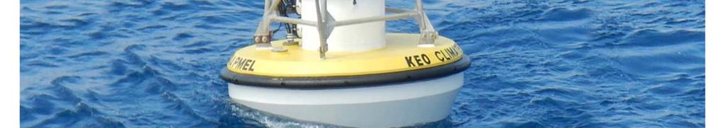
3 YK17-E01 Preliminary Cruise Report 1. Cruise information Makio Honda (JAMSTEC) (1) Cruise designation (research vessel) YK17-E01 (R/V YOKOSUKA) (2) Cruise title and introduction =Title= Emergency Cruise for recovery/re-deployment of drifting NOAA KEO buoy =Introduction= The KEO time-series station in the western Pacific subtropical gyre was established in 2004 by Pacific Marine Environmental Laboratory (PMEL) of National Ocean and Atmosphere Administration (NOAA). For the sake of investigation of air-sea heat and carbon fluxes, a surface buoy mooring which is equipped with various physical and meteorological sensors has been deployed at KEO and has been turned around approximately once a year. In July 2017, the latest mooring system (S/N: KE-015) was deployed (sinker position: N / E) and started time-series observation. Since July 2014, adjacent to KEO buoy, JAMSTEC time-series sediment trap experiment has been conducted in order to investigate nutrient supply mechanism to the oligotrophic subtropical upper layer. For this purpose, JAMSTEC backscatter meters with fluorometer were also installed on KE-015 KEO buoy mooring line. However, KEO buoy accidentally started to leave its nominal position on 19 th October According to position data from GPS system on KEO buoy, in the early stage, KEO buoy drifted westward. Based on sensor signal, mooring system was suspected to be partitioned below 425 m and KEO buoy was suspected to drift with sensors upper 425 m including JAMSTEC backscatter meters. After KEO buoy met the Kuroshio current, it headed to north. Sequentially, in middle November, KEO buoy started to drift eastward along the Kuroshio extension. Although we were afraid of the worst scenario: KEO buoy would drift too far east to be recovered, fortunately, drifting KEO buoy left the Kuroshio extension in late November and headed to south. In early December, along weak clockwise flow south of the Kuroshio extension, KEO buoy was getting closer to its initial position. Indeed, it could have been worse. After occurrence of this accident, NOAA informed this accident to the world and looked for 2
4 any ships available for rescue of drifting KEO buoy, including ships from government (US / Japan coastguard) and private salvage company. On the other hand, NOAA consulted JAMSTE about rescue of drifting KEO buoy. After long discussion, negotiation and big efforts, JAMSTEC decided to send JAMSTEC research vessel, R/V Yokosuka, for this mission under umbrella of Memorandum of Understanding (MOU) between JAMSTEC and NOAA. After rigging mooring gears such as winch and winding machine and loading NOAA equipment, R/V Yokosuka sailed on 19 th December 2017 from JAMSTEC Yokosuka headquarter pier. (3) Principal Investigator (PI) Makio Honda Principal Research Scientist Research and Development Center for Global Change (RCGC) Japan Agency for Marine-Earth Science and Technology (JAMSTEC) (4) Cruise period (port call) 19 December 2017 (JAMSTEC Yokosuka HQ) - 25 December 2017 (JAMSTEC Yokosuka HQ) (5) Cruise region (geographical boundary) The western North Pacific Subtropical area (30 N 35 N / 140 E 150 E) (6) Cruise track 3

5 2. Outline of YK17-E01 Makio Honda (JAMSTEC) (1) Objective of this cruise To recover drifting KEO buoy To re-deploy KEO buoy To recover partitioned mooring remnants (2) Cruise summary Weather and sea condition was not always good for mooring work. We were forced to wait days of recovery and redeployment of KEO buoy for one day each. However we successfully completed this mission impossible. 1) Recovery of drifting KEO buoy Fig. 1 Drifting track of KEO surface buoy between 18 October and 21 December Background is current direction and velocity on 13 December 2017 predicted by Japan Meteorological Agency. 4
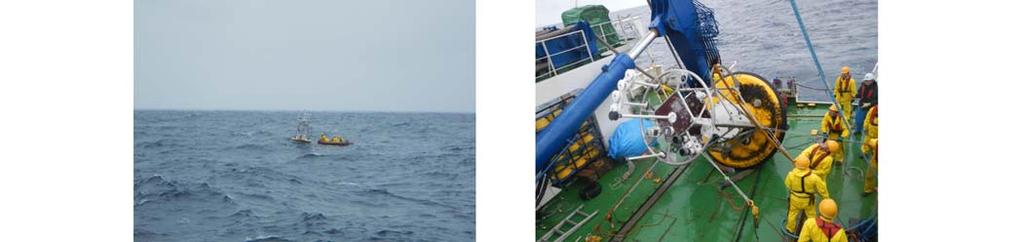
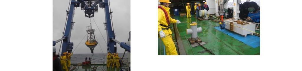
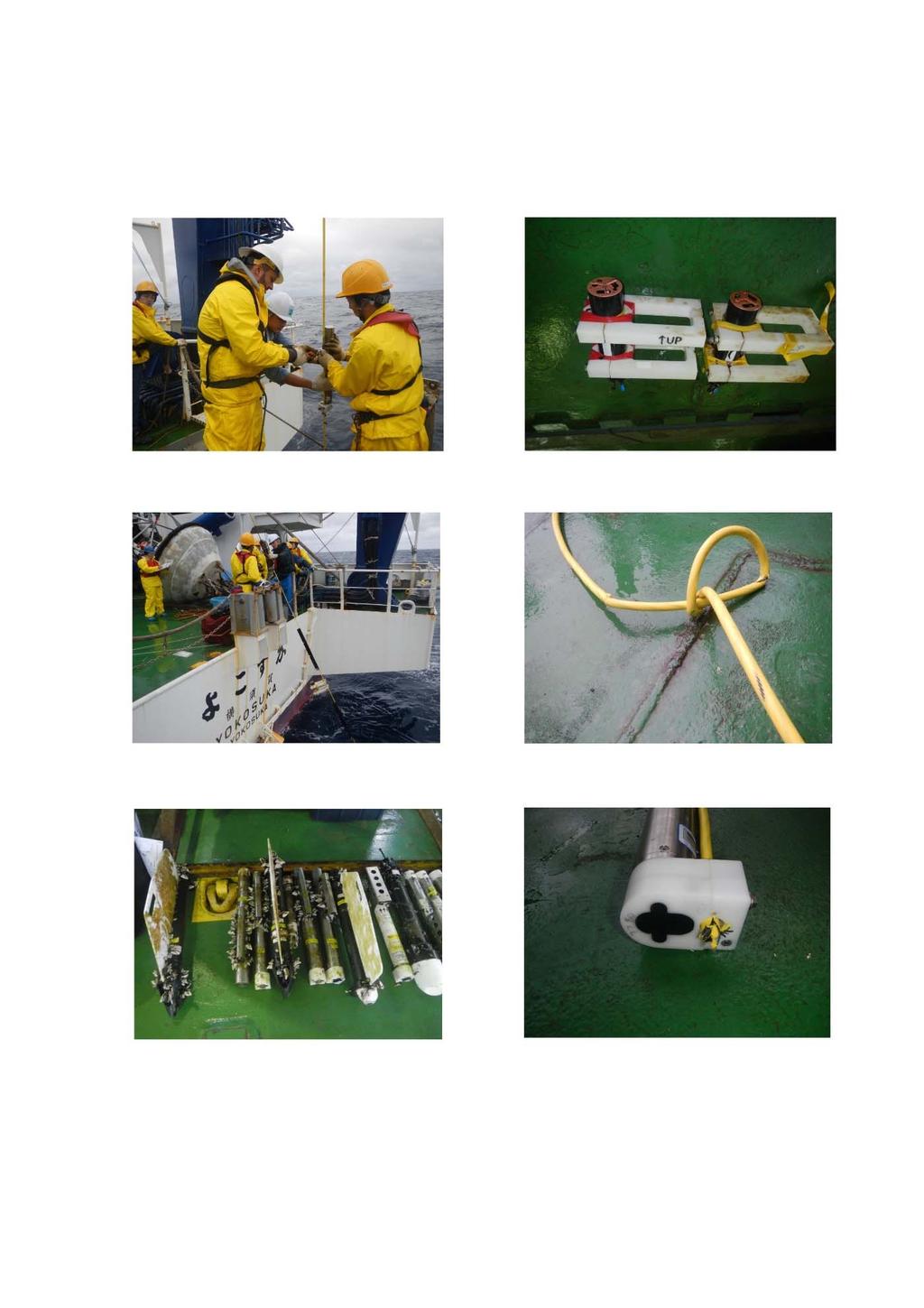
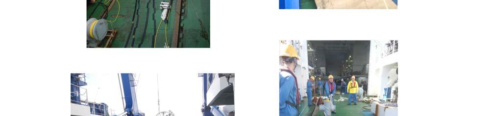
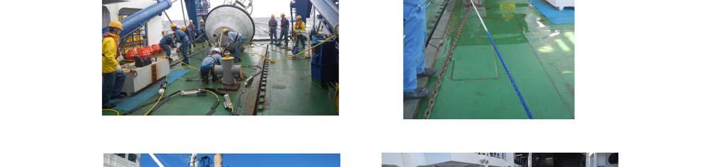
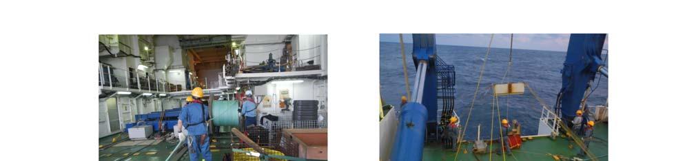
6 In the early morning on 21 st December 2017, the drifting KEO buoy was found at only about 60 miles eastward form the latest anchor position (Fig. 1). Recovery work was conducted safely and successfully. It was found that wire rope was partitioned at about 425 m water depth, just below 425 m CTD sensor. Curiously, there was a knot (or hitch) of wire rope about 13 m above 425 m CTD sensor. Working record for recovery was as follows: 5
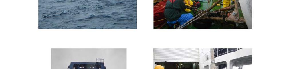
7 6
8 7
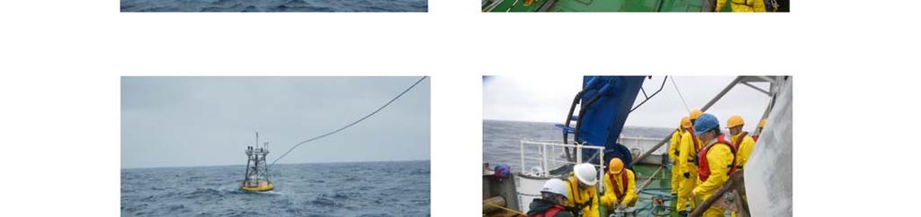
9 2) Redeployment After one day wait / preparation, KEO buoy was successfully re-deployed on 23 rd December Anchor position was determined by using onboard SSBL system. Real time data obtained by KEO buoy mooring is available on NOAA PMEL Kuroshio extension observatory homepage ( KEO buoy will be turnaround in summer Working record for re-deployment was as follows: 8
10 9
11 10
12 3) Recovery of partitioned mooring line Because of bad weather / sea condition and possibility that buoyancy of glass floats was not enough for glass floats, which connects long pp / nylon rope, to be back to sea surface, NOAA decided that recovery of mooring remnant was cancelled during this cruise. (3) Cruise log December th 9:00 (JST) Sail (Yokosuka Headquarter pier) 21 st 8:00 (JST) - Recovery of drifting KEO buoy 23 rd 8:00 (JST) - Redeployment of KEO buoy 25 th 9:00 (JST) Port call (Yokosuka Headquarter pier) (4) Cruise participant Name Affiliation Appointment Makio Honda (PI) RCGC, JAMSTEC Principal Research Scientist Denise Kester University of Washington Research Engineering Technician Ryan Wells University of Washington Research Scientist / Engineer Satoshi Ozawa Marine Works Japan Inc. Marine Technician Shungo Oshitani Marine Works Japan Inc. Marine Technician 11
13 3. KEO buoy mooring work Jennifer Keene (University of Washington) Meghan Cronin (PMEL, NOAA) Denise Kester (University of Washington) Ryan Wells (University of Washington) 3.1 Introduction The NOAA Ocean Climate Stations Kuroshio Extension Observatory (KEO) surface mooring is located south of the Kuroshio Extension current, at 32.3 N, E. It was first deployed in June 2004, as an element of the Kuroshio Extension Systems Study (KESS). KESS was a two-year process study, funded by the National Science Foundation (NSF), to investigate interactions between the Kuroshio Extension and its recirculation gyre. At the conclusion of KESS in February 2007, a NOAA partnership with the Japan Agency for Marine-Earth Science and Technology (JAMSTEC)'s Institute of Observational Research for Global Change (IORGC) was formed, continuing work at the site. The mooring is serviced annually, and was deployed for the 14 th year in July

, and carbon dioxide; surface ocean acidification; and upper ocean temperature, salinity and currents.")

14 Figure 1: History of mooring deployments at KEO site. Current watch circle shown in red. Gray circles show broken remnants. The KEO mooring carries a suite of instrumentation to monitor air-sea exchanges of heat, moisture, momentum (wind stress), and carbon dioxide; surface ocean acidification; and upper ocean temperature, salinity and currents. These data, combined with data from the nearby JAMSTEC sediment trap, enable computation of the physical and biological pumps of the carbon cycle in a key region of the North Pacific. As such, it has become a focal point for international climate research. More information about the mooring and KEO site can be found here: 13
15 SHORT AND LONG WAVE RADIATION: TFLEX FLEX GILL SONIC ANEMOMETER, FLEX GILL SONIC ANEMOMETER, TFLEX CO2 ANTENNA RAIN GAGE(2), FLEX & TFLEX SOLAR LIGHT, FL(5) Y 20s AT/RH, TFLEX MP-101 A AT/RH, FLEX MP101 A RADAR REFLECTOR AT/RH2. FLEX HYGROCLIP DRUCK BAROMETER, FLEX DRUCK BAROMETER, TFLEX INDUCTIVE CABLE BREAKOUT TOP OF WIRE, START FAIRINGS 5 METERS SBE-39IM TP INVERTED TFLEX TUBE TFLEX SYSTEM SOFT VER# 1.12 KEO 2017 PMEL pco2 ELECTRONICS-PMEL SPAN GAS-LUXFER. FLEX SYSTEM SOFT VER# METERS 10 METERS 15 METERS AQUADOPP SBE-37IM TC TC SBE-37IM TC 1 METER: SBE-16 CTD/GTD/02/FLNTU SAMI ph SENSOR 1 METER: METERS SBE 37SMP TC, FLEX SBE 37SMP TC TFLEX 20 METERS 1 1/4" SAS 1 1/4" SAS 2 LINKS 1" CHAIN 1" SAS WRENCH TIGHTEN 3 SHACKLES 23 METERS 25 METERS 35 METERS AQUADOPP SBE-39IM T INVERTED BACKSCATTER/FLUOROMETER SBE-37IM TC SBE-37IM TC 2,322 METERS BOUYANT 7/8" POLYOLEFIN MOORING LINE METERS AQUADOPP 1.1 METERS 1/2" CHAIN 3/4" SAS WITH BUSHING.5 METER 1/2" CHAIN 5/8" SAS 5 TON SWIVEL; LOWER BODY OF SWIVEL ATTACHED TO BALLS 5/8" SAS 5/8" SAS 4 METERS 1/2" CHAIN 40 METERS 50 METERS 68 METERS 75 METERS SBE-39IM T INVERTED SBE-37IM TCP AQUADOPP PROFILER SBE-37IM TCP 18 ea.17" VITROVEX 6,700 METER GLASS BALL FLOATS. 1.5 METER SPACING BETWEEN 2 PACKS. SBE-37SM TCP (DEPTH-56M ABOVE BOTTOM) WELD 3/4" SAS NUT ALL SHACKLES WELDED CLOSED BELOW THIS LINE 5/8" SAS 4 METERS 1/2" CHAIN 5/8" SAS 4 METERS 1/2" CHAIN 5/8" SAS 4 METERS 1/2" CHAIN 5/8" SAS.5 METERS 1/2" CHAIN 3/4" SAS 20 METERS 1 1/8" NYLON 3/4" SAS.5 METER 1/2" CHAIN 3/4" SAS 5 TON SWIVEL 3/4" SAS 5/8" SAS TWIN 8242 ACOUSTIC RELEASES FACTORY CHAIN/RING KIT 5/8" SAS.5 METER 1/2" CHAIN 3/4" SAS 50 METERS 1 1/8" NYLON 3/4" SAS.5 M 3/4" CHAIN 3/4" SAS 5 TON SWIVEL 3/4" SAS 4 M 3/4" CHAIN 3/4" SAS 1 M 1/2" CHAIN 3/4" SAS EYE INTO EYE SPLICE 4,941 METERS CONTINUOUS NYLON LINE. TOTAL, ALL SIZES 100 METERS 103 METERS SBE-39IM TCP BACKSCATTER/FLUOROMETER 125 METERS SBE-37IM TCP 150 METERS, STOP FAIRINGS 150 METERS SBE-37IM TCP 175 METERS SBE-37IM TCP 200 METERS PAL 225 METERS SBE-37IM TCP 240 METERS, RESTART FAIRINGS 275 METERS SBE-37IM TCP 325 METERS 375 METERS 425 METERS 475 METERS 525 METERS 700 METERS FACTORY SPLICED NYLON TAPER 1,070 METERS TOTAL **Wrap 3/4"SAS pin/nut with Vulcanizing Tape,** overwrap with black tape. SBE-37IM TCP 350 METERS, END OF FAIRINGS SBE-39IM TP SBE-37IM TCP SBE-39IM TP SBE-37IM TCP 3/4" SAS, Wrench tighten. ** 3/4" SAS, Wrench tighten. ** 5 TON SWIVEL 3/4" SAS, Wrench tighten. **.5 METER 3/4" CHAIN 1" SAS WITH BUSHING, Wrench tighten. ** 10 METER LENGTH NYLON STIFFENER APPLIED TO TOP OF 1" NYLON ~380 METER LENGTH 1" NYLON Tapered factory spliced to 7/8" nylon ~348 METER LENGTH 7/8" NYLON Tapered factory spliced to 3/4" nylon ~342 METER LENGTH 3/4" NYLON Tapered factory spliced to 11/16" nylon WRENCH TIGHTEN ALL SHACKLES DEPTH: 5760 METERS NOAA-PMEL-KEO MOORING: 7600 Sandpoint Way NE Seattle, Wa (206) KEO-015 3/8" wire rope shackled around anchor shafts ANCHOR BAR ANCHOR WEIGHT 8,240#, AIR WT 7,168#, WET WT. SCOPE: 1.4:1 DRAWN BY: MIKE CRAIG DRAWN AS DEPLOYED: DATE: 23 MARCH 2017 Figure 2: Diagram of NOAA KEO mooring. 14

16 On October 19, 2017, the KEO mooring broke from its anchor and began drifting. It initially moved west, toward Japan. Carried by winds and currents, the buoy began to move north, and then east. There was concern that the buoy would get caught in the jet of the Kuroshio Extension current, and be carried into the open ocean. Surprisingly, it stayed in a recirculation gyre of the current. The buoy had almost returned to its original anchor position by the time it was recovered. Figure 3: GPS positions recorded by the drifting KEO buoy. Immediately after the buoy was known to be adrift, the search for a rescue ship began. Personnel at PMEL reached out to NOAA assets, the US Navy, the US Coast Guard, and private US vessel operators. With assistance from Dr. Honda at JAMSTEC, the Japan Coast Guard was contacted, as well as JMA, and three charter companies to try to find any available vessel to rescue the buoy. The search for a rescue ship continued even after the generous offer was made to use the JAMSTEC fleet, in the hope that the rescue mission could be accomplished sooner. At the time, no one expected the buoy to get caught up in the gyre, and there was concern that it would 15

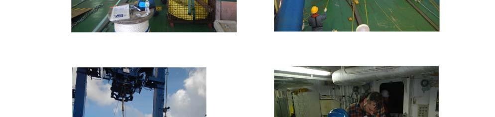
17 get too far away from shore to be rescued at all, if the mission was delayed. Fortunately, the buoy turned back west and was easily recovered aboard the S/V Yokosuka. NOAA and PMEL are very grateful for the aid provided by JAMSTEC for this mission. 3.2 Mission impossible: Recovery / Redeployment (1) Recovery of drifting KEO buoy The ship arrived on site on Thursday, December 21, By 6:30am (local time), the drifting buoy was spotted at N, E. Before operations began, the Chief Officer conducted a safety meeting, and then the small boat was launched with four Japanese crew on board to capture the buoy. Four tag lines were attached to the buoy in addition to the lifting line. Once on deck, the buoy was disconnected and moved out of the way, so that the retrieval of the mooring line and subsurface instruments could begin. For subsurface instrument recovery, the wire was passed through a block on the A- frame. Instruments were removed at the rail, and then carried inside the sub bay for documentation and cleaning. There was no sign of fishing gear on the mooring line. Figure 4: Subsurface instrument being removed from the wire. After about 200m of wire had been recovered, it was already noticeable that the line seemed to be light, with little tension on it. The wire was found to be broken just beneath the 16
 and knot (right) in mooring wire.")
.")
18 bottom clamp of the 425m instrument. Approximately 12.75m above the 425m sensor, there was a knot in the wire. The instrument deployed at 425m was still attached to the wire, though it looked as if it had slid down about 1 on the cable. Figure 5: Break (left) and knot (right) in mooring wire. The broken end of the mooring wire was cut off and sent by air shipment back to PMEL when the ship returned to port. Due to delays in customs clearance, the shipment has not yet left Japan (as of January 12, 2018). When it does reach Seattle, the broken end will be analyzed to try to determine the exact cause of the break. Knots in the wire are unusual, and the cause in this case is unknown. PMEL mooring engineers have never seen a knot or break like this before. Any information learned in the break analysis will be shared with JAMSTEC for future reference. The specifications of the wire rope are as follows: Manufacturer: Loos and Co., Inc. Type: Galvanized steel rope, 3x19 improved plow steel Diameter: 7/16 diameter (jacketed to 1/2 diameter) Minimum Break Strength: 18,400 lbs. The total recovery time from when the small boat contacted the buoy until the last sensor was brought on board was 4 hours and 49 minutes. 17


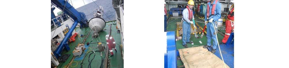
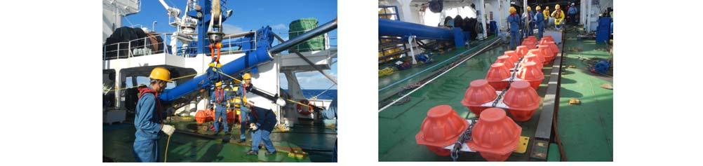
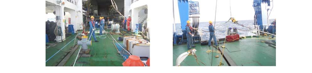
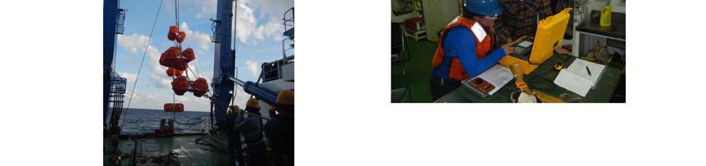
19 (2) Redeployment Redeployment operations began the morning of December 23, The first 60m of wire had been laid out on deck, and instruments and fairings were installed in advance. As the buoy was lifted overboard, this top portion of wire was carried and put into the water by hand. The wire was then run through a block on the A-frame, and the remaining subsurface instruments were installed at the rail. Figure 6: Mooring wire with instruments and fairings installed on deck. The wire was followed by nylon, and then polyolefin line. Several small snags were noticed in the polyolefin during deployment. These were wrapped with electrical tape for extra precaution. Glass balls were attached and lowered into the water from the A-frame. Another short section of nylon was put in-line, followed by dual acoustic releases. The buoy and mooring line were towed for about two hours, while the anchor was moved into position. (The size and shape of the anchors made this process difficult.) The anchor was deployed through the A-frame. Figure 7: Block anchors deployed through the A-frame. 18
20 The final anchor position and water depth were determined by using the ship s SSBL system to range on the acoustic release. The anchor fallback was 231.7m. Water depth was 5,707m, making the final mooring scope 1.435:1. Final anchor position: N, W The total deployment time, from the time the buoy was lifted off the deck until the anchor was dropped was 7 hours and 43 minutes. (3) Recovery of partitioned mooring system Though it was hoped that the partitioned mooring remnant at the anchor location could be recovered during this cruise, the decision was made not to attempt recovery. After learning where in the line the mooring broke, there was concern that the glass balls at the bottom of the mooring would not have enough floatation to bring the gear to the surface quickly. The gear could be carried far away from the ship in subsurface currents. Also, with poor weather conditions, it could be difficult to see the gear on the surface. Jennifer Keene at PMEL made the decision not to try to recover the remnant during this cruise. NOAA PMEL Acknowledgements: In addition to the acknowledgements below, NOAA PMEL extends special thanks to Dr. Makio Honda for his role in making this mission possible. Acknowledgment Captain and ship crew of R/V Yokosuka Marine technician from Marine Works Japan Inc. JAMSTEC board members including Director Dr. Asahiko Taira and JAMSTEC colleagues from Ship operation department Research support department International affair division 19
RR10106 Cruise Plan ITOP Mooring Recovery and PhilSea10 Seaglider Operation (R/V Revelle November 6-26, 2010)
") RR10106 Cruise Plan ITOP Mooring Recovery and PhilSea10 Seaglider Operation (R/V Revelle November 6-26, 2010) Chief Scientist: Ren-Chieh Lien, Applied Physics Lab, University of Washington Co-Chief Scientist:
RR10106 Cruise Plan ITOP Mooring Recovery and PhilSea10 Seaglider Operation (R/V Revelle November 6-26, 2010) Chief Scientist: Ren-Chieh Lien, Applied Physics Lab, University of Washington Co-Chief Scientist:
Cruise Plan for QPE (R/V Revelle Sept/ 12-16, 2009)
") Cruise Plan for QPE (R/V Revelle Sept/ 12-16, 2009) Objectives In this cruise we will recover six subsurface ADCP/TC moorings (Lien), five restrained ADCP (Centurioni), and perform shipboard ADCP, Revelle
Cruise Plan for QPE (R/V Revelle Sept/ 12-16, 2009) Objectives In this cruise we will recover six subsurface ADCP/TC moorings (Lien), five restrained ADCP (Centurioni), and perform shipboard ADCP, Revelle
MAPCO2 Buoy Metadata Report Project Title:
 MAPCO2 Buoy Metadata Report Project Title: Autonomous Multi-parameter Measurements from a Drifting Buoy During the SO GasEx Experiment Funding Agency: NOAA Global Carbon Cycle program PI(s): Christopher
Ocean Observatories Initiative (OOI) Moorings: New Capabilities for Seagoing Science
 Moorings: New Capabilities for Seagoing Science") Ocean Observatories Initiative Ocean Observatories Initiative (OOI) Moorings: New Capabilities for Seagoing Science presented by Ed Dever and Walt Waldorf November 20, 2014 OOI Science Themes Coastal and
Ocean Observatories Initiative Ocean Observatories Initiative (OOI) Moorings: New Capabilities for Seagoing Science presented by Ed Dever and Walt Waldorf November 20, 2014 OOI Science Themes Coastal and
NSF's Ocean Observatories Initiative: Building Research Infrastructure for the Pacific Northwest and the Broader Community
 Agenda Item B.3.b Supplemental OOI PowerPoint April 2013 Ocean Observatories Initiative NSF's Ocean Observatories Initiative: Building Research Infrastructure for the Pacific Northwest and the Broader
Mooring Modifications for the Reduction of Losses to Vandalism
 Mooring Modifications for the Reduction of Losses to Vandalism H. Paul Freitag Chris Meinig Andrew J. Shepherd Pacific Marine Environmental Laboratory Seattle, Washington, USA Linda D. Stratton JISAO/University
Cruise Plan, Alford IWISE leg, June 10-20, 2011
 Cruise Plan, Alford IWISE leg, June 10-20, 2011 version 2; dated 5/20/2011 Overview/Objectives The following is the updated cruise plan for the mooring deployment leg (6/10-6/20) of the Internal Waves
RV Southern Surveyor program
 2011 RV Southern Surveyor program voyageplan SS2011_c01 Tsunami Detection Buoy Maintenance for Australian Tsunami Warning System (ATWS) Itinerary Mobilise 0700 Sydney, Tuesday 5 April 2011 Depart Sydney
Noise Experiment #2. Marine Physical Laboratory Scripps Institution of Oceanography La Jolla, CA February 22 February 2010
 Noise Experiment #2 Marine Physical Laboratory Scripps Institution of Oceanography La Jolla, CA 92093-0701 16 February 22 February 2010 1. Objective The objective of the noise experiment is to observe
CRUISE REPORT FOR UW BERING STRAIT MOORING PROJECT 2005 Rebecca Woodgate, University of
 CRUISE REPORT FOR UW BERING STRAIT MOORING PROJECT 2005 Rebecca Woodgate, University of Washington,woodgate@apl.washington.edu CCGC Sir Wilfrid Laurier 2005-05 Kodiak, 8 th July 2005 Barrow, 22nd July
Pioneer Array Micro-siting Public Input Process Frequently Asked Questions
 Pioneer Array Micro-siting Public Input Process Frequently Asked Questions The National Science Foundation (NSF) has completed the micro-siting of the moored array of the Ocean Observatories Initiative
voyageplan SS Itinerary Principal Investigator(s) RV Southern Surveyor program
 RV Southern Surveyor program") 2008 RV Southern Surveyor program voyageplan SS04-2008 RESEARCH CHARTER Deep-Ocean Tsunami Detection Buoy (DART) Scheduled Maintenance Replacement for the Australian Tsunami Warning System (ATWS) Itinerary
2008 RV Southern Surveyor program voyageplan SS04-2008 RESEARCH CHARTER Deep-Ocean Tsunami Detection Buoy (DART) Scheduled Maintenance Replacement for the Australian Tsunami Warning System (ATWS) Itinerary
Atmospheric Forcing and the Structure and Evolution of the Upper Ocean in the Bay of Bengal
 DISTRIBUTION STATEMENT A. Approved for public release; distribution is unlimited. Atmospheric Forcing and the Structure and Evolution of the Upper Ocean in the Bay of Bengal J. Thomas Farrar and Robert
CMORE HOE DYLAN October 2012 Draft cruise plan
 CMORE HOE DYLAN 11 1 4 October 2012 Draft cruise plan Cruise ID: KM12-21 Vessel: R/V KILO MOANA University of Hawaii Master of the Vessel: Captain Gray Drewry Chief Scientist: Tara Clemente (UH) OTG Marine
Sensor Platform Project Marine Trials Bidders Conference. Fundy Ocean Research Center for Energy fundyforce.ca
 Sensor Platform Project Marine Trials Bidders Conference Fundy Ocean Research Center for Energy fundyforce.ca 1 Project Team FORCE OceanWorks International Preliminary Design, Operational Procedures Murray
R/V Point Sur Pre-Cruise Questionnaire
 R/V Point Sur Pre-Cruise Questionnaire Please fill this out and return at least 40 days prior to your cruise to ensure that all of your technical needs can be met BASIC INFO Purpose of Cruise: Submitter's
BACKGROUND TO STUDY CASE
 BACKGROUND TO STUDY CASE German Aerospace Center (DLR) is using Andøya Rocket Range for a sounding rocket campaign. On 27th October 2005 a 300 kg payload (SHEFEX) was launched Due do a technical problems
ARG Mooring Deployment
 ARG Mooring Deployment The acoustic releases are lifted over the stern during the mooring deployment. The mooring deployment was scheduled for early November as the rainy season in southwestern Greece
The Next Generation Easy-to-Deploy (ETD) Tsunami Assessment Buoy
 Tsunami Assessment Buoy") The Next Generation Easy-to-Deploy (ETD) Tsunami Assessment Buoy R.A. Lawson and D. Graham Science Applications International Corporation 4025 Hancock Street San Diego, CA 92110 USA S. Stalin, C. Meinig,
The Next Generation Easy-to-Deploy (ETD) Tsunami Assessment Buoy R.A. Lawson and D. Graham Science Applications International Corporation 4025 Hancock Street San Diego, CA 92110 USA S. Stalin, C. Meinig,
3 Solutions Found for Irish Research Vessels. A CTD Davit design
 3 Solutions Found for Irish Research Vessels A CTD Davit design A Vibration Damping Solution Managing mooring chain on a small vessel Bill Dwyer, P&O Maritime Services Ltd Celtic Voyager & Celtic Explorer
QUICK START GUIDE CB-950 DATA BUOY PLATFORM
 What s Included (1) Buoy hull with data well, 950 lb buoyancy (1) Buoy tower (3) 40W Solar panels (1) Data well lid (isic-cb or pass-through) (3) Top-side lifting eyes (3) Bottom-side mooring eyes (1)
OVER-SIDE OVERBOARD HANDLING SYSTEM R/V SIKULIAQ Top Level Maximum Capability Document
 OVER-SIDE OVERBOARD HANDLING SSTEM R/V SIKULIAQ Top Level Maximum Capability Document Manufactured By: XXX Reference Drawing Number: XXX-XXX Prepared By: [Company Name] [Engineer s Name/Stamp] [Date] Page
Cargo and hull damage while at anchor in heavy weather
 October 2017 Cargo and hull damage while at anchor in heavy weather A small general cargo vessel loaded steel cargo at several different ports. At the first port the vessel loaded steel plates and at the
KAIYO Cruise Report. KY15-05Leg2. Construction of DONET2 system. Off Kii Channel. Kumano-nada. March.12 March.29, 2015
 KAIYO Cruise Report KY15-05Leg2 Construction of DONET2 system Off Kii Channel Kumano-nada March.12 March.29, 2015 Japan Agency for Marine-Earth Science and Technology (JAMSTEC) Contents 1. Cruise Information...
Appendix 11-B Anchor Handling Systems, Set Up and Handling
 Revision History Revision Date Section Changes Number 1 Sept 1 Permanent Chaser Pendant (PCP) Drawing updated 2018 2 Pennant Buoy System Drawing updated 3 Working Wire/Chaser Termination on Drawing updated
NT10-18 NATSUSHIMA / HYPER-DOLPHIN
 NT10-18 NATSUSHIMA / HYPER-DOLPHIN Kumano-Nada October 2010 Earthquake and Tsunami Research Project for Disaster Prevention JAMSTEC TABLE OF CONTENTS 1. INTRODUCTION 2. SCHEDULE 3. DIVE RESULTS 4. CONCLUSIONS
R/V Natsushima Cruise Report NT15-21
 R/V Natsushima Cruise Report NT15-21 Survery for SIP cable observation system Off Izu-Oshima Dec.8,2015-Dec.16,2015 Japan Agency for Marine-Earth Science and Technology (JAMSTEC) Contents 1. Cruise Information
National Report of China
 National Report of China Yu Ting (NMDIS), State Oceanic Administration (SOA), China DBCP 29, 27 Sep. 2013, Paris, France Contents 1 Current program status 2 Future deployment plan 3 Technical development
Synthesis of marine debris modeling and observations: recent progress in understanding and applications
 2016 New Year Symposium on Marine Litter Ministry of the Environment, Government of Japan, Tokyo University of Marine Science and Technology, January 23-24, 2016 Synthesis of marine debris modeling and
CB-40 Data Buoy Quick Start Guide
 CB-40 Data Buoy Quick Start Guide The NexSens CB-40 Data Buoy offers a compact and affordable platform for deploying water quality sondes and other instruments that integrate power and data logging. The
Implementation and Effect of Major Oil Recovery System Exercises
 Implementation and Effect of Major Oil Recovery System Exercises by Svein Edward Kjellsen Senior Executive Officer Norwegian Pollution Control Authority Commercial Services Unit Implementation and Effect
RESULTS FROM PARACHUTE SEA ANCHOR DRAG TESTS FOR A SPACE CAPSULE, Jan. 10, 2013
 FIORENTINO Technical Report FPA-152 Report Prepared for: America s next generation of spacecraft A spacecraft can be a diameter of 16.5-foot and weigh 18,000 lbs. at splashdown. When the parachute sea
Stability of Temperature and Conductivity Sensors of Argo Profiling Floats
 Journal of Oceanography, Vol. 6, pp. 5 to 58, Short Contribution Stability of Temperature and Conductivity Sensors of Argo Profiling Floats EITAROU OKA * and KENTARO ANDO Frontier Observational Research
DIVE PLAN Leg 1 Dive 11 Recover Wally 1
 DIVE PLAN Leg 1 Dive 11 Recover Wally 1 Page 1 of 6 Location: Barkley Canyon Date: 9 May, 2014 14:00 Constraints: Weather, Sufficient deck space ROV Dive # OE 114 Objectives Prepare Wally I cable for recovery
***This summary does not include shad and herring net requirements.***
 South Carolina Department of Natural Resources Marine Resources Division Summary of Seine and Gill Net Laws (Saltwater) 2013-2014 This document should be kept on board all vessels using seines or gill
Natsushima Cruise Report NT Sea trial of Autonomous Underwater Vehicle. Yumeiruka around Omuro-dashi. Sagami Bay, Suruga Bay and Omuro-dashi
 Natsushima Cruise Report NT15-11 Sea trial of Autonomous Underwater Vehicle Yumeiruka around Omuro-dashi Sagami Bay, Suruga Bay and Omuro-dashi July 5, 2015 July 10, 2015 Japan Agency for Marine-Earth
KY10-15 KAIYO / HYPER-DOLPHIN
 KY10-15 KAIYO / HYPER-DOLPHIN Kumano-Nada January 2011 Earthquake and Tsunami Research Project for Disaster Prevention JAMSTEC TABLE OF CONTENTS 1. INTRODUCTION 2. SCHEDULE 3. DIVE RESULTS 4. CONCLUSIONS
Draft of OKMC Cruise Plan (R/V Revelle June 1-14, 2012 RR1205)
") Draft of OKMC Cruise Plan (R/V Revelle June 1-14, 2012 RR1205) Ren-Chieh Lien and Thomas B Sanford 1. Objectives In the RR1205 cruise, we will deploy five subsurface moorings, one surface mooring (TBD),
Draft of OKMC Cruise Plan (R/V Revelle June 1-14, 2012 RR1205) Ren-Chieh Lien and Thomas B Sanford 1. Objectives In the RR1205 cruise, we will deploy five subsurface moorings, one surface mooring (TBD),
PRELIMINARY CRUISE REPORT, W9909C R/V WECOMA, September 1999 GLOBEC/ENSO Long-Term Observations off Oregon
 Submitted by Jane Fleischbein College of Oceanic & Atmospheric Sciences Oregon State University Corvallis, Oregon 97331-553 flei@oce.orst.edu, 541.737.5698 FILING DATE: 1 October 1999 PRELIMINARY CRUISE
QUICK START GUIDE CB-450 DATA BUOY PLATFORM
 What s Included (1) Buoy hull with data well, 450 lb buoyancy (1) Buoy tower (3) 10W Solar panels (1) Data well lid (isic-cb or pass-through) (3) Top-side lifting eyes (3) Bottom-side mooring eyes (1)
Oceans and the Global Environment: Lec 2 taking physics and chemistry outdoors. the flowing, waving ocean
 Oceans and the Global Environment: Lec 2 taking physics and chemistry outdoors the flowing, waving ocean Peter Rhines 1 Eric Lindahl 2 Bob Koon 2, Julie Wright 3 www.ocean.washington.edu/courses/has221a-08
KAIYO CRUISE REPORT. KY15-16 Leg1
 KAIYO CRUISE REPORT KY15-16 Leg1 Construction of DONET2 Off Kii Channel Oct.16,2015-Nov.6,2015 Japan Agency for Marine-Earth Science and Technology (JAMSTEC) 1 Contents 1. Cruise Information -----------------------------------------
The Wave Glider: A Mobile Buoy Concept for Ocean Science. 009 Liquid Robotics Inc.
 The Wave Glider: A Mobile Buoy Concept for Ocean Science 009 Liquid Robotics Inc. J. Manley & T. Richardson: Liquid Robotics Inc. DBCP XXV Paris September 28, 2009 1 Wave Glider Overview Unique Two Part
Western Canadian Spill Services Ltd. Field Testing Exercise Report
 Western Canadian Spill Services Ltd. Field Testing Exercise Report Wednesday, July 15, 2009 Clearwater River, Rocky Mountain House, AB Background Western Canadian Spill Services Ltd. (WCSS) held a field
volvooceanrace.com Volvo Ocean Race Science programme Preliminary results Leg 6 Hong Kong to Auckland
 Volvo Ocean Race Science programme Preliminary results Leg 6 Hong Kong to Auckland Preliminary results Leg 6 Compiled using data provided by Dr Toste Tanhua & Dr-Ing. Sören Gutekunst, GEOMAR Helmholtz
QUICK START GUIDE CB-150 DATA BUOY PLATFORM
 What s Included (1) Buoy hull with data well, 150 lb buoyancy (1) Buoy tower (3) 6W Solar panels (1) Data well lid (isic-cb or pass-through) (3) Top-side lifting eyes (3) Bottom-side mooring eyes Common
NT09-21 Cruise Report SURUGA-BAY Cable Laying Experiment / VBCS Function Test
 NT09-21 Cruise Report SURUGA-BAY Cable Laying Experiment / VBCS Function Test December 2009 Table of Contents 1. Overview 2. Schedule 3. Dive Summary 4. Concluding Remarks 1. Overview A unique development
Cable Grid Testing 2018 Panama City Beach Trawl Diving and TED Testing
 NOAA FISHERIES Cable Grid Testing 2018 Panama City Beach Trawl Diving and TED Testing TIII Evaluation with NEFSC Flounder Trawl TII Evaluation with Kites TI Video Documentation Nicholas Hopkins 7/20/2018
Stevpris installation
 chaser Stevpris deployment for MODUs Introduction Typical methods for deployment and retrieval of Stevpris anchors with an anchor handling vessel (AHV) are described, focusing on the use of chasers for
Institute of Marine Research
 Institute of Marine Research CRUISE REPORT NO. ** R/V G.O. Sars Cruise No. 2005108 9 th June 24 th June 2005 Coral survey off Northern Norway Principal Scientist J. H. Fosså 2005 Benthic Habitat Research
Application for Consent to Conduct Marine Scientific Research. F Internal Waves in Straits (IWISE) Institution Contact Information Director
 Institution Contact Information Director") 1. General Information 1.1 Reference ID: Application for Consent to Conduct Marine Scientific Research Application number: Project name: F2010-111 Internal Waves in Straits (IWISE) 1.2 Sponsoring institution(s):
1. General Information 1.1 Reference ID: Application for Consent to Conduct Marine Scientific Research Application number: Project name: F2010-111 Internal Waves in Straits (IWISE) 1.2 Sponsoring institution(s):
CB-50 Data Buoy Quick Start Guide
 CB-50 Data Buoy Quick Start Guide The NexSens CB-50 Data Buoy is designed for quick deployment in emergency response situations including industrial spills and natural disasters. The buoy can be deployed
XRAY GLIDER Underwater Video Cruise Plan May 21, 22, 23, 2007 R. G. Sproul
 XRAY GLIDER Underwater Video Cruise Plan May 21, 22, 23, 2007 R. G. Sproul Purpose The ONR program manager for the XRAY/Liberdade underwater flying wing glider has requested that an underwater video of
WEBB RESEARCH CORPORATION
 Use spacebar or arrow keys to advance slide show WEBB RESEARCH CORPORATION Falmouth, MA APEX Profiler SLOCUM Glider Rev: 06/22/08 WEBB RESEARCH CORPORATION Specialists in neutrally buoyant drifters and
ATON System Workshop
 ATON System Workshop ATON System: Real-time current measurements from Coast Guard navigation buoys in ports, bays and the coastal ocean Aid-to-Navigation = ATON ATON System Workshop Outline: Overview of
DEVELOPMENT OF SUBSURFACE FADS IN THE PACIFIC ISLANDS REGION, INCLUDING DEPLOYMENT OF TWO SUBSURFACE FADS IN NEW CALEDONIA
 DEVELOPMENT OF SUBSURFACE FADS IN THE PACIFIC ISLANDS REGION, INCLUDING DEPLOYMENT OF TWO SUBSURFACE FADS IN NEW CALEDONIA INTRODUCTION The introduction of fish aggregating devices (FADs) to the Pacific
WHOTS Mooring Subsurface Instrumentation
 UH Contributions to WHOTS-13 Cruise Report by Fernando Santiago-Mandujano, Daniel McCoy, Jefrey Snyder, R. Walter Deppe, Kellen Rosburg, Glenn Carter, Katrina Berry, and Roger Lukas WHOTS Mooring Subsurface
Yokosuka Cruise Report YK11-02
 Yokosuka Cruise Report YK11-02 Sea Trial of The HETL Fuel Cell System for Underwater Platform JAMSTEC ~ Sagami-Bay ~ JAMSTEC March 6, 2011 ~ March 9, 2011 Japan Agency for Marine-Earth Science and Technology
FINAL REPORT DERELICT FISHING GEAR REMOVAL PROJECT PORT GARDNER
 1900 W. NICKERSON, STE. 207 SEATTLE, WASHINGTON 98119-1650, U.S.A. TELEPHONE: (206) 285-3480 TELEFAX: (206) 283-8263 E-Mail : jjune@nrccorp.com (corporate) FINAL REPORT DERELICT FISHING GEAR REMOVAL PROJECT
South Bay Coastal Ocean Observing System California Clean Beaches Initiative
 South Bay Coastal Ocean Observing System California Clean Beaches Initiative Quarterly Report September 2003 to City of Imperial Beach Eric Terrill 1 1 Scripps Institution of Oceanography, University of
Instructions for Support Boat Duties
 Instructions for Support Boat Duties You must attend the Race day and safety briefing in the committee room (usually at 8.30am) You should bring your own lifejacket with you as the club does not have any
RV Southern Surveyor. program. voyagesummaryss02/2010
 2009 RV Southern Surveyor program voyagesummaryss02/2010 SS02/2010 IMOS-Southern Ocean Time Series Facility Voyage period Start: 16/03/2010 End: 22/03/2010 Port of departure: Hobart, Tasmania, Australia
MA MARINE ACCIDENT INVESTIGATION REPORT
 MA2013-4 MARINE ACCIDENT INVESTIGATION REPORT April 26, 2013 The objective of the investigation conducted by the Japan Transport Safety Board in accordance with the Act for Establishment of the Japan Transport
Wave Glider: Liege Colloquium. Colloquium April 27
 The The Wave Wave Glider: Glider: Enabling Enabling aa New New Approach Approach to to Persistent Persistent Ocean Ocean Observation Observation and and Research Research nd Liege 42 42nd Liege Colloquium
Original URI Scanfish MKII
 Scanfish MKII URI s Scanfish MKII Sensors include CTD, Fluorometer, Dissolved Oxygen and Seabird Fast Temperature and Conductivity Sensors logging at 400 Hz and sending 50 Hz data via 9600 Baud uplink
Location: Barkley Canyon Date: September 9, 2013 Constraints: none
 Page 1 of 11 DIVE PLAN R1650 Location: Barkley Canyon Date: September 9, 2013 Constraints: none Objectives Deploy POD 1 autonomous CTD Survey POD 3 for sediment enrichment sites; deposit cages; collect
Chapter 9: Sea operations
 Chapter 9: Sea operations ANTARES takes advice from IFREMER for the sea operations, which concern the installation and recovery of the different components of the detector : Junction Box, Strings, Interconnecting
Current-induced wave modulations observed by a GPS wave buoy deployed near Kozu Island, Japan
 Current-induced wave modulations observed by a GPS wave buoy deployed near Kozu Island, Japan Keiji Kiyomatsu, Adrean Webb, Takuji Waseda The University of Tokyo Nov/09/2015 Introduction Outline Background
Oceanographic Research With The LiquID Station
 Oceanographic Research With The LiquID Station Application Note OCEANOGRAPHIC RESEARCH The field of oceanography relies on knowing the precise physical, chemical, and biological state of seawater at different
OFFSHORE PATROL VESSEL OPERATIONS
 Florida Fish and Wildlife Conservation Commission Division of Law Enforcement OFFSHORE PTROL VESSEL OPERTIONS GENERL ORDER EFFECTIVE DTE RESCINDS/MENDS PPLICBILITY 30 May 7, 2018 July 21, 2008 ll Sworn
Variability in the tropical oceans - Monitoring and prediction of El Niño and La Niña -
 Variability in the tropical oceans - Monitoring and prediction of El Niño and La Niña - Jun ichi HIROSAWA Climate Prediction Division Japan Meteorological Agency SST anomaly in Nov. 1997 1 ( ) Outline
Anchor and Anchor Cable Losses. Athens, Greece, 2 nd February 2018 Capt. Simon Rapley
 Anchor and Anchor Cable Losses Athens, Greece, 2 nd February 2018 Capt. Simon Rapley Anchor Loses Items lost: Whole anchors Anchor crowns Anchor and shackles of cable Anchor and entire anchor cable Shank
MARINE ACCIDENT INVESTIGATION REPORT
 MARINE ACCIDENT INVESTIGATION REPORT December 8th,2016 Adopted by the Japan Transport Safety Board Member Kuniaki Shoji Member Satoshi Kosuda Member Mina Nemoto Accident Type Contact (light buoy) Date
Fully Submersible Heavy Lift Vessel
 Fully Submersible Heavy Lift Vessel Arnbjorn Joensen Aberdeen Maritime Branch (28th January 2015) PRESENTATION Introduction to the Subsea Deployment Vessel Installation method Tank test video Potential
1.0 PURPOSE AND NEED
 1.0 PURPOSE AND NEED 1.0 PURPOSE OF AND NEED FOR THE PROPOSED ACTION 1.1 INTRODUCTION The National Environmental Policy Act (NEPA) of 1969, as amended (42 United States Code Section 4321 et seq.); the
1990 Sandy Bottom Anchor Tests
 1990 Sandy Bottom Anchor Tests Conducted by NAV-X Corporation (manufacturers of the Fortress Marine Anchors) Approved to present by Brian Sheehan of NAV-X Anchor tests were conducted on February 17-18,
Figure 8.8. Figure Oceanography 10 Ocean Circulation. Gulf Stream flows at 55 million cubic meters/sec, 500 times the flow of the Amazon River
 Oceanography 10 Ocean Circulation PART 1: Introduction General types of Ocean Currents Solar Energy and the Seasons PART 2: Measuring Ocean Currents and Structure PART 3: General Surface Currents and their
05 Boat Handling. Captain
 05 Boat Handling Competence (Skills) Knowledge, Understanding and Proficiency Level Required Boat handling theory and techniques Coxswain Crew RQ RQ Describe the forces acting on a vessel while manoeuvering
Yasuhisa ISHIHARA Marine Technology Center JAMSTEC
 Tsunami Warning Buoy System and an Acoustic Telemetry System for High Current Area Yasuhisa ISHIHARA Marine Technology Center JAMSTEC Contents 1. Large depth Surface Buoy Mooring TRITONBuoyand GlobalTropical
AFT OVERBOARD HANDLING SYSTEM: OCEANOGRAPHIC TRACTION WINCH FLAG BLOCK R/V SIKULIAQ Maximum Capability Document
 AFT OVERBOARD HANDLING SSTEM: OCEANOGRAPHIC TRACTION WINCH FLAG BLOCK R/V SIKULIAQ Maximum Capability Document Manufactured By: Rapp Hydema Model: XXXX Reference Drawing Number: XXXX Prepared By: The Glosten
Instructions for Support Boat Duties
 Instructions for Support Boat Duties You must attend the Race day and safety briefing in the committee room ( usually at 8.45am) You should bring your own lifejacket with you as the club does not have
Right Whale Diving and Foraging Behavior in the Southwestern Gulf of Maine
 DISTRIBUTION STATEMENT A. Approved for public release; distribution is unlimited. Right Whale Diving and Foraging Behavior in the Southwestern Gulf of Maine Mark Baumgartner Woods Hole Oceanographic Institution
Update on Canadian Research Vessels Ship Procurement Projects
 Update on Canadian Research Vessels Ship Procurement Projects 28 th International Research Ship Operators Meeting (IRSO) La Jolla, California October 2012 Jennifer Vollrath 1 Outline National Ship Building
Class B Accident Report. Melilla 201 Man Overboard
 Class B Accident Report Melilla 201 Man Overboard 96 Nautical Miles south of Stewart Island on 19 November 2004 REPORT NO: 04 3607 MELILLA 201 MAN OVERBOARD FATALITY At 0545 hours New Zealand Standard
GOVERNMENT GAZETTE REPUBLIC OF NAMIBIA
 GOVERNMENT GAZETTE OF THE REPUBLIC OF NAMIBIA N$4.00 WINDHOEK - 19 November 2015 No. 5877 CONTENTS Page GOVERNMENT NOTICES No. 269 No. 270 Regulations to reduce incidental by-catch of seabirds in the hake
The below identified patent application is available for licensing. Requests for information should be addressed to:
 DEPARTMENT OF THE NAVY NAVAL UNDERSEA WARFARE CENTER DIVISION NEWPORT OFFICE OF COUNSEL PHONE: (401) 832-3653 FAX: (401) 832-4432 NEWPORT DSN: 432-3653 Attorney Docket No. 96811 Date: 14 May 2008 The below
JIMAR PFRP ANNUAL REPORT FOR FY 2006
 JIMAR PFRP ANNUAL REPORT FOR FY 2006 P.I./Sponsor Name: Michael P. Seki and Jeffrey J. Polovina Project Proposal Title: Oceanographic Characterization of the American Samoa Longline Fishing Grounds for
Rope-less Fishing: A vision for how it can work
 Rope-less Fishing: A vision for how it can work Mark Baumgartner (WHOI), Tim Werner (NEAq), Amy Knowlton (NEAq), Michael Moore (WHOI), and Scott Kraus (NEAq) The need The latest assessment of the North
SIDE OVERBOARD HANDLING SYSTEM: CTD WINCH R/V SIKULIAQ Maximum Capability Document
 SIDE OVERBOARD HANDLING SYSTEM: CTD WINCH R/V SIKULIAQ Maximum Capability Document Manufactured By: Rapp Hydema Model: HW/CTD-2330T90, T90 Spooling Reference Drawing Number: RH313724 Prepared By: The Glosten
NOAA/NWFSC Southern California Shelf Rockfish Hook and Line Survey
 NOAA/NWFSC Southern California Shelf Rockfish Hook and Line Survey NOAA Fisheries, Northwest Fisheries Science Center 2725 Montlake Blvd. E, Seattle, WA 98112 John Harms, NOAA/NWFSC Jim Benante, PSMFC/NWFSC
Deep SOLO. Nathalie Zilberman, Dean Roemmich, and SIO float lab. 1. Deep SOLO float characteristics. 2. Deep SOLO float Deployment
 Deep SOLO Nathalie Zilberman, Dean Roemmich, and SIO float lab 1. Deep SOLO float characteristics 2. Deep SOLO float Deployment 3. Deep SOLO temperature and salinity Deep SOLO Float deployment, R/V Tangaroa
Demonstrate basic knowledge of the operation of pleasure/small craft by day
 Page 1 of 7 Title Demonstrate basic knowledge of the operation of pleasure/small craft by day Level 2 Credits 6 Purpose This unit standard is for pleasure craft operators and covers knowledge required
"Real-Time Vertical Temperature, and Velocity Profiles from a Wave Glider"
 DISTRIBUTION STATEMENT A. Approved for public release; distribution is unlimited. "Real-Time Vertical Temperature, and Velocity Profiles from a Wave Glider" Luca Centurioni Scripps Institution of Oceanography
AFT OVERBOARD HANDLING SYSTEM R/V SIKULIAQ Top Level Maximum Capability Document
 AFT OVERBOARD HANDLING SYSTEM R/V SIKULIAQ Top Level Maximum Capability Document Manufactured By: XXX Reference Drawing Number: XXX-XXX Prepared By: [Company Name] [Engineer s Name/Stamp] [Date] Page 1
Sea Views SEACAMS. month s edition. In this. Business aboard the RV Prince Madog What do seals do underwater? All aboard the RV Prince Madog
 February 2013 SEACAMS Sea Views In this month s edition Business aboard the RV Prince Madog What do seals do underwater? All aboard the RV Prince Madog 0845 519 9029 www.seacams.ac.uk ebost: email: info@seacams.ac.uk
1 Module A (uniform topography) survey lines Module B (topographic wake) survey lines Module C (submesoscale soup) survey lines...
 survey lines Module B (topographic wake) survey lines Module C (submesoscale soup) survey lines...") ..................................................................................... point Sal Coastal circulation Experiment (SCoNE) / SP1723 CRUISE PLAN ANDRÉ PALÓCZY R/V Robert Gordon Sproul, September/10
..................................................................................... point Sal Coastal circulation Experiment (SCoNE) / SP1723 CRUISE PLAN ANDRÉ PALÓCZY R/V Robert Gordon Sproul, September/10
STUDENT WORKBOOK Nautical Knots & Maritime Careers
 STUDENT WORKBOOK Nautical Knots & Maritime Careers Figure 8 Cleat Hitch Bowline Slippery Hitch Sheep Shank Clove Hitch Monkey s Fist 1 Instructions 1. Read the career profiles to find out who uses these
Kabouter (Trapper 300) yacht for Sale 5999
 yacht for Sale 5999") Kabouter (Trapper 300) yacht for Sale 5999 The Trapper 300s were all built as dual-purpose cruiser-racers. In total about 180 were built by Trapper Yachts of Poole and in common with most other quarter-tonners
Kabouter (Trapper 300) yacht for Sale 5999 The Trapper 300s were all built as dual-purpose cruiser-racers. In total about 180 were built by Trapper Yachts of Poole and in common with most other quarter-tonners
Reliance Industries, LLC. Installation, Operation, Inspection and Maintenance Instructions for the Skyline Horizontal Lifeline System
 Reliance Industries, LLC Installation, Operation, Inspection and Maintenance Instructions for the Skyline Horizontal Lifeline System 6300 Permanent Lifeline System using 3/8 7x19 Steel Wire Rope with the
NATIONAL MARINE FISHERIES SERVICE (NMFS) REPORT ON HIGHLY MIGRATORY SPECIES (HMS) ACTIVITIES
 REPORT ON HIGHLY MIGRATORY SPECIES (HMS) ACTIVITIES") Agenda Item J.1.a NMFS Report 1 March 2019 NATIONAL MARINE FISHERIES SERVICE (NMFS) REPORT ON HIGHLY MIGRATORY SPECIES (HMS) ACTIVITIES Deep-set Buoy Gear (DSBG) Authorization and National Environmental
Agenda Item J.1.a NMFS Report 1 March 2019 NATIONAL MARINE FISHERIES SERVICE (NMFS) REPORT ON HIGHLY MIGRATORY SPECIES (HMS) ACTIVITIES Deep-set Buoy Gear (DSBG) Authorization and National Environmental