REVISED MAY U.S. Coast Guard Abandoned Vessel Program SECTOR MARYLAND - NATIONAL CAPITAL REGION HANDBOOK FOR AUXILIARY COXSWAINS
|
|
|
- Quentin Gallagher
- 5 years ago
- Views:
Transcription

1 REVISED MAY 2017 U.S. Coast Guard Abandoned Vessel Program SECTOR MARYLAND - NATIONAL CAPITAL REGION HANDBOOK FOR AUXILIARY COXSWAINS
2 To all Auxiliary Coxswains in Sector Maryland - NCR: The Sector Commander has asked the Auxiliary to help put into effect a new Abandoned Vessel Program that the Coast Guard has created to help monitor abandoned vessels. The program is designed eventually to make use of observations reported by all vessels on Chesapeake Bay, from cargo ships and workboats to fishing vessels and recreational boats. For now, the Auxiliary will participate in a pilot program designed to test the system out and build up a data-base. Technically, this isn t new for Auxiliary patrol crews. It s always been one of our missions to monitor and report on abandoned vessels in the Sector. What s new about this is the way we ll be reporting what we find. The Coast Guard has set up a computerized reporting system to track these vessels and record them in a data-base, and we ll be using that system in our work. Although this is still only a voluntary program, I m strongly encouraging all Auxiliary coxswains in Sector Maryland - NCR to participate regularly on all your patrols and to consider it part of your standard operating procedure. This booklet will outline the new simple procedure for obtaining a list of abandoned vessels in your AOR and their location just before you go out on patrol; for checking on them while you re under way; and for sending the information (and, hopefully, a digital photo of them) to Sector Maryland - NCR when you return. Please read this thoroughly and plan to make this part of your regular patrol to-do list. This is an important program for the Coast Guard and for us. Thank you very much. Rob Sersen District Captain, Sector Maryland - NCR
3 IN THIS BOOKLET On the next few pages, you ll find: (a) Instructions on what to do before, during and after your patrol. (b) A copy of the Coast Guard s derelict/neglected vessel worksheet, to make it easier for you to take notes while you re on patrol. (c) A copy of the rating matrixǁ that the Coast Guard has designed to help you describe the vessel and what condition it is in. (d) A map of Auxiliary patrol areas (Auxiliary Areas of Responsibility, or AORs), and a list and description of their boundaries. (e) A set of frequently asked questions (and answers). PHOTOCOPYING OF THIS BROCHURE PROVIDED BY THE LAW FIRM OF PEPPER HAMILTON LLP OF WASHINGTON, D.C., IN APPRECIATION OF THE FINE WORK AND DEDICATION OF THE UNITED STATES COAST GUARD AUXILIARY.
4 WHAT TO DO BEFORE YOU GO OUT ON PATROL: 1. Assemble the equipment you ll need: Binoculars A GPS receiver A digital camera Several printed copies of Abandoned Vessel Form (see below) A copy of the rating matrix (scale for rating abandoned vessels), which appears as part of this handbook. 2. Go online to the Abandoned Vessel Program website at: The website will ask for your user name and password. You ll need to get those from your flotilla or division operations officer (we aren t listing them here because this handbook is a public document). Once you enter the website, click on the AVP DATABASE and log in. Then: (a) Once you ve got the AVP DATABASE on your screen, find the words Search forǁ at the left side of the light-blue band near the top. In the blank box, just to the right of the words Search for,ǁ click on the arrow at the right of the box. A drop-down window will appear showing several categories (or fields) of data. Click on the line that says Patrol areaǁ and click once again to lock it in the window. Then skip over the second blank box in that row and go to the third blank box and type in the name of the river or area of responsibility (AOR) that you plan to patrol (example: South River). You ll see the number and formal name of your AOR appear in a drop-down window located just below the box (example: 10 SOUTH, WEST RIVERS). Note: You can type in a name of a river if it corresponds to a designated AOR. However, if nothing appears when you do that for example, suppose you type in Patuxent River and the name of the AOR doesn t come up then you ll need to type in the name of the AOR, which in that case is SOLOMONS ISLAND. If nothing comes up when you type in the name of the AOR, that means that no one has yet entered any reports relating to that area. Whatever report that you file will be the first one to be listed under your AOR. (b) Click on the name of the AOR in the drop-down window, and it will appear in the box itself (example: 10 SOUTH, WEST RIVERS). Then click on the SEARCH button at the right of the box. You ll see a list of all the items that you or others who patrol that AOR have entered before.
5 (c) Click on the words PRINTER FRIENDLY VERSION in the gray section at the top of the data base. Go to the horizontal gray bar at very top of your screen (for your browser) and click FILE. Then click on PAGE SETUP and
6 set your printer orientationǁ to LANDSCAPE.ǁ This will print the information horizontally so you can fit it all in without running off the page. Print out the listing for your AOR and take it with you on patrol. (d) Also print a few copies of the separate AVP worksheet provided at the bottom of the website homepage. Take them with you on your patrols to use in making notes. DURING YOUR PATROL: 1. As you patrol, visit each of the vessels listed and note whether there has been any change since the last time that it was checked. Is it still there? Has it begun to list or sink? Is it leaking and spewing pollutants into the water? Compare the entry on your printout to the actual situation. Note the lat/long, description of the vessel and other piece of information that you ll need, and take digital photos of the boat from all sides. Use the rating matrix as a guide for the kind of information you ll need to update the database. 2. Also, please be on the lookout for other abandoned vessels that may not be in the database yet. Such boats may be anywhere beached along the shoreline, in a marina or out in open water. If it looks as though the boat has been abandoned for example, if it s partly sunken or is listing badly please report it anyway, and the Coast Guard will decide whether it s a problem. Note: Approach the vessel slowly and carefully. Do not leave your own boat to board the abandoned vessel under any ci rcumstances. If someone is on board the boat or standing nearby ask questions. But if the person seems adversarial, do not confront or challenge him or her. If you can t locate a vessel that s on the list, write NOT FOUND across the form. When you come upon a vessel that looks as though it s been abandoned, note its lat/long, name, type of boat and general situation, and take a set of digital photos. Again, use the matrix as a guide for the kind of information that you ll need when you get home. If you find an abandoned vessel that is adrift, or is leaking gasoline, diesel fuel or some other substance, or seems to be sinking, immediately call the Sector Maryland - NCR Operations Center at and report it, and wait for further instructions.
7 WHEN YOU GET BACK HOME: Just call up the website again when you return, go back to the database, and click on ADD NEW at the left. Fill in the blanks, following the form indicated for lat/long, telephone numbers, etc. When you ve finished each item, click on SAVE at the bottom of the website. 1. Go back online the Abandoned Vessel Program website at: Log onto the database with your user name and password. Once you enter the website, click on ADD NEW at the left side of the column headings. Fill out the online form that appears. Attach any digital photos that you have taken. 2. Be sure to use the standard formats shown on the entry form. For example, telephone numbers should be listed with dashes, as (not ). For Lat/Long, please use the digital format shown on your GPS, not the degrees/minutes/seconds format that you d use on a paper chart. If you need to convert degrees/minutes/seconds to a digital format, call up for an easy-to-use converter. 3. When you have completed the form, click on the SAVE button at the bottom. Some important points to remember when you file your report: If you check on a vessel that was entered previously in the database and nothing has changed since the last entry, just click on EDIT next to that entry and type in the date of the patrol that you just conducted. Please do not change anything else in the entry. If the status of that vessel has changed since the last entry for example, if it has sunk deeper into the water or has moved from its previous position, then click on EDIT next to that entry and type in the new information in place of what was there before. Please do NOT create a new, separate entry each time you need to update a previous listing. Note: This is a pilot version of this program, so you probably can expect some initial glitches. If you encounter any problems, please don t hesitate to call Auxiliarist Bill Howard, AVP technical support, at william.howard@cgauxnet.us or
8 U.S. COAST GUARD SECTOR Maryland - NCR Abandoned Vessel Reporting Worksheet NOTE: IF VESSEL IS ADRIFT, LEAKING OR SINKING, CALL SECTOR COMMAND CENTER IMMEDIATELY AT Is this a new entry, not already on database? Yes No If vessel is already on database, what is its ID number? Your patrol area (AOR): Location of vessel: N. Lat. W.Long. Vessel name: Home port: Vessel registration number (MD or USCG or VIN): Color (hull, cabin), description: Estimated length overall: feet Beam: feet Propulsion: Hull material: wood fiberglass steel aluminum other Date: Time: Distance from vessel: Water depth: Have you seen vessel before? How long has it been here? USE MATRIX BELOW TO ASSIGN 1-5 RANK UNDER TODAYǁ TODAY BEFORE PUBLIC SAFETY HULL CONDITION: Note holes in hull, broken planks, rust, broken ports POSITION IN WATER: Listing, low in stern or bow, grounded, sunken HOW SECURED: Tied securely to dock tied but not secure on mooring buoy anchored NAVIGATION HAZARD: HAZARD: PUBLIC VISIBILITY: TOTAL SCORE FROM ALL OBSERVATIONS RECORDED ABOVE: Does vessel appear to have someone associated with it? Is there fishing gear aboard? Your name: Your ID number: Your phone:
9
10
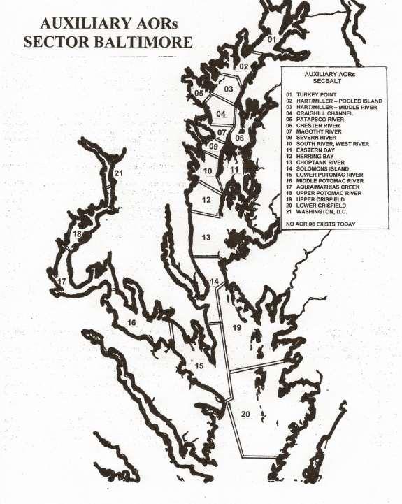
11 AUXILIARY AORs SECBALT 01 TURKEY POINT 02 HART/MILLER POOLES ISL 03 HART/MILLER MIDDLE RVR 04 CRAIGHILL CHANNEL 05 PATAPSCO RIVER 06 CHESTER RIVER 07 MAGOTHY RIVER 09 SEVERN RIVER 10 SOUTH, WEST RIVERS 11 EASTERN BAY 12 HERRING BAY 13 CHOPTANK RIVER 14 SOLOMONS ISLAND 15 LOWER POTOMAC RIVER 16 MIDDLE POTOMAC RIVER 17 AQUIA/MATHIAS CREEK 18 UPPER POTOMAC RIVER 19 UPPER CRISFIELD 20 LOWER CRISFIELD 21 WASHINGTON, D.C. NO AOR 08 EXISTS TODAY SPONSIBILITY (AORs) FOR AUXILIARY PATROLS SECTOR Maryland - NCR AOR 01 TURKEY POINT Northern boundary is the Maryland-Delaware border just north of Chesapeake City on the Chesapeake and Delaware (C&D) Canal. Southern boundary is a line from Romney Creek ( N, W) easterly to Howell Point ( N, W). Orders issued by Auxilary Division 21. AOR 02 POOLES ISLAND Northern boundary is a line from Romney Creek ( N, W) east to Howell Point ( N, W). Southern boundary is a line from Wells Point ( N, W) easterly to Pooles Island Bar Light ( N, W), then southeasterly to Tolchester Beach ( N, W). Orders issued by Auxiliary Division 22. AOR 03 HART/ MILLER ISLAND Northern boundary is a line from Wells Point ( N, W) easterly to Pooles Island Bar Light ( N, W), then southeasterly to Tolchester Beach ( N to W). Southern boundary is a line from North Point (3911.7N, W), easterly to Swan Point ( N, W). Orders issued by Auxiliary Division 22. AOR 04 CRAIGHILL CHANNEL Northern boundary is a line drawn from North Point (3911.7N, W) easterly to Swan Point ( N, W). Eastern boundary is a line from Swan Pt. ( N, W) southerly to Love Point Light ( N, W). Southern boundary is a line from Love Point Light westerly to Mountain Point ( N, W). Western boundary is a line along the shore from Mountain Point ( N, W) to Rock Point ( N, W) then northerly to North Point. Orders issued by Auxiliary Division 22.
12 AOR 05 PATAPSCO RIVER Eastern boundary is a line from North Point ( N, W) southerly to Rock Point ( N, W). Orders issued by Auxiliary Division 22. AOR 06 CHESTER RIVER Western boundary is a line from Swan Point ( N, W) southerly to Love Point Light ( N, W) southwesterly to Love Point ( N, W). The southern boundary is the north side of the Kent Narrows Bridge. Orders issued by Auxiliary Division 21. AOR 07 MAGOTHY RIVER Northern boundary is a line from Mountain Pt ( N, W easterly to Love Point Light ( N, W southwesterly to Love Point ( N, W). Southern boundary is a line from the Western end of the Bay Bridge ( N, W) through a point ( N, W) to the Eastern end of the Bay Bridge ( N, W). This line represents a midpoint which passes between the north and south spans of the bridge. Orders issued by Division 23. AOR 08 BAY BRIDGE This AOR no longer exists and has been apportioned between the Magothy River and Severn River patrol areas. AOR 09 SEVERN RIVER Northern boundary is a line from the Western end of the Bay Bridge ( N, W) through a point ( N, W) to the Eastern end of the Bay Bridge ( N, W). The line represents a midpoint that passes between the north and south spans of the bridge. Southern boundary is a line drawn from Tolley Point ( N, W) easterly to the range lights (marks) at Kent Island ( N, W). Orders issued by Auxiliary Division 23. AOR 10 SOUTH RIVER/WEST RIVER Northern boundary is a line from Tolley Point (3856.5N, W) easterly to the southern range lights (marks) at Kent Island ( N, W). Eastern boundary is a line from Kent Point ( N, W southerly to Lowes Point ( N, W). Southern boundary is a line from Cedarhurst ( N, W) southeasterly to Lowes Point ( N, W). Orders issued by Division 24. AOR 11 EASTERN BAY Western boundary is a line from Lowes Point ( N, W) northerly to Kent Point ( N, W). Northern boundary is the south side of the Kent Narrows Bridge. Orders issued by Division 21. AOR 12 HERRING BAY Northern boundary is a line from Cedarhurst ( N, W) southeasterly to Lowes Point ( N, W). Southern boundary is a line from Chesapeake Beach ( N, W) easterly to Blackwalnut Point ( N, W). Orders issued by Division 24. AOR 13 CHOPTANK RIVER Northern boundary is a line from Chesapeake Beach ( N, W) easterly to Blackwalnut Point ( N, W). Southern boundary is a line from Kenwood Beach ( N, W) easterly to the southern tip of James Island ( W, W) to the northwest point of Taylor s Island ( N, W). Orders issued by Division 21. AOR 14 SOLOMONS ISLAND Northern boundary is a line from Kenwood Beach east to James Island. Southern boundary is a line from ( N, W) on the Western shore in St. Mary s County easterly to the boundary of Station Crisfield near the HS buoy at ( , W), including all tributaries along the western shore of this patrol area. Orders issued by Auxiliary Division 23. AOR 15 LOWER POTOMAC Northern boundary is a line from ( N, W) on the western shore in St. Mary s county easterly to the boundary of Station Crisfield near the HS buoy at ( N, W), southeasterly to the Maryland-Virginia state line and southwesterly along that line to Smith Point. Western boundary is a line from Ragged Point (38
13 08.95N, W on the Virginia shore of the Potomac River, north to White Point Beach on the Maryland shore. Orders issued by Division 23 and Flotilla 10 of Division 03. AOR 16 MIDDLE POTOMAC RIVER Eastern boundary is a line from Ragged Point ( N, W) on the Virginia shore to the Maryland shore at White Point Beach ( N, W). Western boundary is the Governor Harry Nice Bridge (Route 301). Orders issued by Division 25. AOR 17 AQUIA/ MATHIAS CREEK Eastern boundary is the Governor Harry Nice Memorial Bridge (Route 301). Northern boundary is a line parallel to the power lines at Moss Point, running from ( N, W) to ( N, W). Orders issued by Division 25. AOR 18 UPPER POTOMAC RIVER Southern boundary is a line parallel to the power lines at Moss Point, running from ( N, W) to ( N, W). Northern boundary is the Woodrow Wilson Bridge ( N, W. Orders issued by Auxiliary Division 25. AOR 19 UPPER CRISFIELD Northern boundary is a line from ( N, W) southwesterly to ( N, W). Western boundary is a line from ( N, W), southerly to the midpoint of the western boundary of Crisfield ( N, W). Southern boundary is a line from the midpoint of the western boundary of Crisfield ( N, W) to the northwest tip of Smith Island ( N, W) to the mouth of the northern tip of the Big Annemessex River ( N, W). This includes the Nanticoke River to Seaford, Delaware; the Wicomico River to Salisbury, Maryland; and the Manokin River to its head. Orders issued by Division 12. AOR 20 LOWER CRISFIELD Northern boundary is a line from the midpoint of the western boundary of Crisfield ( N, W) to the northwest tip of Smith Island ( N, W) and then to the mouth of the Big Annemessex River northern tip ( N, W). Western boundary is a line along the western boundary of Station Crisfield ( N, W). Southern boundary is a line from ( N, W). The AOR also includes the Pocomoke River to Snow Hill, Maryland, and the Annemessex River to its head. Orders issued by Division 12. AOR 21 WASHINGTON, D.C. Southern boundary is the Woodrow Wilson Bridge from ( N, W) to ( N, W). Northern boundary is the Chain Bridge ( N, W) and the Whitney Young Memorial Bridge ( N, W). Orders issued by Auxiliary Division 25.
14 FREQUENTLY ASKED QUESTIONS: Where can I get the most current version of this Abandoned Vessel Program Handbook? Call up the AVP website and print out the handbook on your home computer. Since this is a work in progress, we may revise the handbook frequently. Please check periodically to make sure that you have the latest one. What if I find an obviously abandoned vessel tied up to a dock? Generally speaking, if a vessel is tied to a dock it is not abandoned under the regulations If the dock-owner tells you the vessel doesn t belong to him, the state of Maryland will sometimes assist in removal, but the Coast Guard is prohibited from doing that. In such cases, it s not necessary to enter the vessel on the AVP data-base. If a vessel that you ve entered previously is tied up to a dock and is submerged, please do not delete it. The Coast Guard still wants it kept in the database. What if I find an abandoned vessel that is leaking gasoline, diesel fuel, or some other substance? Immediately call the Sector Maryland - NCR Command Center at to report your findings and await further instructions. What if I find an abandoned vessel that looks like it is interfering with waterway navigation or may do so in the near future? If it appears to be an immediate threat to navigation, contact the Sector Maryland - NCR Command Center at and ask the duty officer to contact the Waterways Management Division. How many photos should I take, and what resolution and format should they be? JPEG formats are the easiest for the AVP program to handle, but any format will be acceptable. If you use a format other than JPEG, please note that in the message that you send accompanying the photos. If possible, please send medium resolution images (under 500K). More detailed instructions and help will be on the website. Questions? Contact Phil Wentz, assistant district staff officer for operations, ADSO-OP (SB), at or wentzpj_1@verizon.net.
CHAPTER 260. (House Bill 964) Atlantic Coastal Bays Dredging for Oysters and Clams Prohibition
 Atlantic Coastal Bays Dredging for Oysters and Clams Prohibition") MARTIN O MALLEY, Governor Ch. 260 CHAPTER 260 (House Bill 964) AN ACT concerning Atlantic Coastal Bays Dredging for Oysters and Clams Prohibition FOR the purpose of prohibiting the use of dredging to catch
MARTIN O MALLEY, Governor Ch. 260 CHAPTER 260 (House Bill 964) AN ACT concerning Atlantic Coastal Bays Dredging for Oysters and Clams Prohibition FOR the purpose of prohibiting the use of dredging to catch
BookletChart. Chesapeake Bay Tangier Sound, Northern Part NOAA Chart A reduced-scale NOAA nautical chart for small boaters
 BookletChart Chesapeake Bay Tangier Sound, Northern Part NOAA Chart 12231 A reduced-scale NOAA nautical chart for small boaters When possible, use the full-size NOAA chart for navigation. Published by
UNOFFICIAL COPY OF HOUSE BILL 853 CHAPTER
 UNOFFICIAL COPY OF HOUSE BILL 853 M2 6lr1662 By: Delegates Bozman, Cane, V. Clagett, Conway, and Hixson Introduced and read first time: February 8, 2006 Assigned to: Environmental Matters Committee Report:
PEACE RIVER SENIOR MEN'S TENNIS LEAGUE
 PEACE RIVER SENIOR MEN'S TENNIS LEAGUE HANDBOOK FOR CAPTAINS -updated Oct. 15/2016 Table of Contents A. Introductory Remarks...2 B. Peace River Website...2 Teams and Schedules... 2 Setting Team Cookie...
Boat Name. Hailing Port. Registration # MMSI # Misc:
 NSHSA USEFUL INFORMATION Boat Name Hailing Port Length Beam Draft Mast Height Electric Fuel Burn Rate Fuel Tank Capacity Water Tank Capacity Registration # MMSI # Misc: PASSPORT TO ADVENTURE THE PASSPORT
LOCAL NOTICE TO MARINERS
 USCG Notice to Mariners 3/7/18 (View full Notice here) LNM 10/18 Coast Guard District 1: U.S. Department of Homeland Security United States Coast Guard LOCAL NOTICE TO MARINERS COASTAL WATERS FROM EASTPORT,
Appendix B-2 Maps of Maryland Chesapeake Bay Watershed
 Appendix B-2 Maps of Maryland Chesapeake Bay Watershed Major Allocation Basins Bay Water Quality Segment-Sheds Counties & Segment-Sheds 8-Digit Watersheds & Segment-Sheds Table of Maryland Bay Water Quality
BookletChart. Intracoastal Waterway Matecumbe to Grassy Key NOAA Chart A reduced-scale NOAA nautical chart for small boaters
 BookletChart Intracoastal Waterway Matecumbe to Grassy Key NOAA Chart 11449 A reduced-scale NOAA nautical chart for small boaters When possible, use the full-size NOAA chart for navigation. Published by
LOCAL NOTICE TO MARINERS
 USCG Notice to Mariners 3/26/15 (View full Notice here) LNM 12/15 Coast Guard District 1 : U.S. Department of Homeland Security United States Coast Guard LOCAL NOTICE TO MARINERS COASTAL WATERS FROM EASTPORT,
Seventeenth Coast Guard District Auxiliary Policy Directive 01-07
 Commander Seventeenth Coast Guard District Director of Auxiliary PO Box 25517 Juneau, AK 99802-5517 Staff Symbol: dpa Phone: 907-463-2252 Fax: 907-463-2256 Email: Robert.C.Gross@uscg.mil Seventeenth Coast
GN21 Frequently Asked Questions For Golfers
 Posting Scores (My Score Center) 1. Click on the Enter Score button to enter an adjusted gross score or click on the Enter Hole-By-Hole Score button to enter your score hole-by-hole. NOTE: to use the Game
BVIS Beach Volleyball Information System
 BVIS Beach Volleyball Information System Developments in computer science over the past few years, together with technological innovation, has in turn stimulated the development of tailored software solutions
23 August 2016 Page: 1
 Merging Player Records (Match Records function) There is a function in the Admin>Members>Member Database section that allows administrators to merge records for their players to amalgamate their statistics.
BookletChart. Chesapeake Bay Severn and Magothy Rivers NOAA Chart A reduced-scale NOAA nautical chart for small boaters
 BookletChart Chesapeake Bay Severn and Magothy Rivers NOAA Chart 12282 A reduced-scale NOAA nautical chart for small boaters When possible, use the full-size NOAA chart for navigation. Published by the
Handbook for Captains Updated August 2018
 Handbook for Captains Updated August 2018 Table of Contents A. Introduction 3 B. Suncoast Website 3 Teams & Schedules 3 Setting Team Cookie 3 Rules & The Code 4 Contacts 4 Forms and Documents 4 History
VESSEL REGISTRATION # P.O. BOX Rev. 09/10 BATON ROUGE, LA OPERATOR BOATING INCIDENT REPORT PAGE 1 of
 LOUISIANA DEPARTMENT OF WILDLIFE AND FISHERIES LAW ENFORCEMENT DIVISION DWF-BIR-010-OP VESSEL REGISTRATION # P.O. BOX 98000 Rev. 09/10 BATON ROUGE, LA 70898-9000 OPERATOR BOATING INCIDENT REPORT PAGE 1
Berkeley Island Marine Pre-Rental Instructions. If you do not have a
 Berkeley Island Marine Pre-Rental Instructions. If you do not have a safe boating certificate or a boat license in the state of NJ, or an equivalent in another state, you must take this instruction. Approximate
Mentoring in the USCG Auxiliary Boat Crew Program Coxswain Mentoring Template
 Notes: 1. When there is no reading assignment specified, the entire chapter contains references to the topic. 2. The study questions in the Qualification Guide should be completed for each task. Boat Crew
U.S. Aids To Navigation System Brochure U.S. Coast Guard, Office of Aids to Navigation (202) ,
 ,") AIDS TO NAVIGATION Learning Objectives: As a result of this session the participant should: Understand the principal buoyage systems in the United States. Become aware of the characteristics of the buoy
AIDS TO NAVIGATION Learning Objectives: As a result of this session the participant should: Understand the principal buoyage systems in the United States. Become aware of the characteristics of the buoy
 Page 1 of 6 Nav-Aid Basics Unlike the roads and highways that we drive on, the waterways we go boating on do not have road signs that tell us our location, the route or distance to a destination, or of
USA Jump Rope Tournament Software User Guide 2014 Edition
 USA Jump Rope Tournament Software User Guide www.usajumprope.org Table of Contents Contents System Requirements... 3 System Conventions... 4 Phase 1 Tournament Pre registration Preparation... 5 Name Your
Special Local Regulations and Safety Zones; Recurring Marine. Events and Fireworks Displays within the Fifth Coast Guard
 This document is scheduled to be published in the Federal Register on 04/16/2015 and available online at http://federalregister.gov/a/2015-08756, and on FDsys.gov 9110-04-P DEPARTMENT OF HOMELAND SECURITY
Outrigger Canoes. Our Quarterly Newsletter. October 2016 Flotilla
 October 2016 Flotilla 091-22-04 Our Quarterly Newsletter FORT WAYNE, IN - The Guiding Light is, hopefully, an informative history of the recent activities of Flotilla 091-22-04. It is published quarterly.
Plymouth Thanksgiving Parade Your Invitation photos and text from Andrew Butler
 Flotilla 65, 1 st District Northern Volume 9, No. 5 October 2017 Plymouth Thanksgiving Parade 2017 - Your Invitation photos and text from Andrew Butler On Saturday November 18 the annual Thanksgiving Day
AID VERIFIER QUIZ. 1. How often is the Light List published? a. One a year b. Twice a year c. Every Month d. Quarterly
 Qualification as an Aid Verifier in the Auxiliary presumes a knowledge of navigational aids above that of the ordinary member. Questions on the subject may be directed to the AV as he/she is considered
1. An aid to navigation is any object external to the boat that: 1) helps a boater pilot a boat safely, 2) aids a boater in finding position and 3)
 helps a boater pilot a boat safely, 2) aids a boater in finding position and 3)") 1. An aid to navigation is any object external to the boat that: 1) helps a boater pilot a boat safely, 2) aids a boater in finding position and 3) a. marks the best fishing holes. b. provides a place
1. An aid to navigation is any object external to the boat that: 1) helps a boater pilot a boat safely, 2) aids a boater in finding position and 3) a. marks the best fishing holes. b. provides a place
Heart Foundation Walking Website user guide for Walk Organisers
 Heart Foundation Walking Website user guide for Walk Organisers Proudly supported by Website User Guide for Walk Organisers Contents 1. Introduction... 2 1.1 Finding the HFW website... 2 1.2 Log in on
Boat Name Phone Owner Name Skipper s Name Phone Length, Beam, Draft, Height Power, Sail or Human Registration/Doc # Sponsor Total on Board
 For Chamber use only Boat Number Payment Method Payment Amount December 1, 2018 from 5-9PM. Salty Sam s Marina Boat Application Boat Name Phone Owner Name_ Email Skipper s Name Phone Length, Beam, Draft,
Website User Guide for Walk Organisers
 Website User Guide for Walk Organisers Contents 1. Introduction... 2 1.1 Finding the HFW website... 2 1.2 Log in on the HFW website... 2 2. Your Dashboard Screen... 4 3. Basic Online Profile Features...
Suez Canal grounding with pilot onboard
 August 2016 Suez Canal grounding with pilot onboard The oil tanker was transiting the Suez Canal and had loaded crude oil in North Africa, and was on its way to India. On the bridge were the pilot, master,
NOTE: Arlington Soccer has added additional instructions to this guide to assist team registrars
 p. 1 v.4.0 NOTE: Arlington Soccer has added additional instructions to this guide to assist team registrars HELP! Can t find a screen, button or link? AFFINITY (VYSA Database Software Provider) Uploads
An Introduction To Marine Charts
 An Introduction To Marine Charts //captnmike.com Revised August 29, 2011 An Illustrated introduction to U. S. Aids to Navigation in the Shilshole Bay area of Puget Sound, Washington. The chart symbols
Summer Kick-Off Party
 EXCITING ANNOUNCEMENTS Summer Kick-Off Party Saturday, June 16th, 11am - 3pm Page 1 Tickets to the event are FREE but please RSVP for head count. To RSVP, call the Front Office at 301-261-9500 or email
Chesapeake Bay. Sea - Seek. Ebook Sailing guide / Guide nautique. Chesapeake Bay. NW Atlantic Ocean - US - East coast
 Sea - Seek Ebook Sailing guide / Guide nautique NW Atlantic Ocean - US - East coast Table of contents... 1 1 - Anchorage Marina (Baltimore)... 2 2 - Fairlee Creek... 2 3 - Craighill Channel... 3 4 - Craighill
The LA/LB Harbors handle more than 5,500 commercial vessel arrivals per year (excluding local coastwise and Catalina Island traffic).
.") X. SMALL CRAFT For the purpose of the Los Angeles and Long Beach Harbor Safety Plan, pleasure vessels, commercial fishing vessels and sportfishing boats are designated as small craft. A. BACKGROUND: The
X. SMALL CRAFT For the purpose of the Los Angeles and Long Beach Harbor Safety Plan, pleasure vessels, commercial fishing vessels and sportfishing boats are designated as small craft. A. BACKGROUND: The
For running only the scoresheet application without any video features only some very basic hardware / software requirements have to be fulfilled:
 Digital Scoresheet user manual Requirements For running only the scoresheet application without any video features only some very basic hardware / software requirements have to be fulfilled: Laptop, preferably
Good first day even if you did have to motor keep me posted I enjoy them
 Left HPYC at 12X12 this afternoon. Due to lack of wind we motored to Meredith Creek off of Whitehall bay just north of the Severn River. Anchored off of Carlton Mitchell's mansion. The entrance is fairly
Towing Officers' Assessment Record: Western Rivers
 Towing Officers' Assessment Record: Western Rivers NAME: LICENSE NO.: Task No. Considered Proficient Common Element Task or Duty DE's Initials Date A. Vessel Familiarization A.1. X Locate and demonstrate
Club s Homepage Use this feature to return the club s website.
 The first time the golfer logs into the Internet Golf Reservation System, the member # is the club assigned golfer number, the default password is 1234. The golfer will automatically be transferred to
HOW TO SETUP ROUND ROBIN IN DARTS FOR WINDOWS
 Edition: 1p2 06-Aug-2008 Previous editions: 05-Aug-2008 Author : RB Appr. : RB All pages in this document shall have the same edition number 3AQ 20080805 AAAD Ed. 1p2 Page 1 of 7 TABLE OF CONTENTS 1.SCOPE...3
Slide 1 - Welcome to an Overview of the Student Center and New Titan Online
 Slide 1 - Welcome to an Overview of the Student Center and New Titan Online Page 1 of 64 Slide 2 - This web-based tutorial is brought to you by Information Technology and Student Administration Staff.
Guide to Providing Shoreside and Underway Training Opportunities to Sea Cadets & Sea Scouts
 Guide to Providing Shoreside and Underway Training Opportunities to Sea Cadets & Sea Scouts The purpose of this document is to provide guidance for providing shoreside and underway training opportunities
The Complete 100 Day Dash Guide Updated May 7, 2013
 The Complete 100 Day Dash Guide Updated May 7, 2013 This guide covers the following topics (click the links to read more): Official Rules Frequently Asked Questions (FAQs) How to Register for the Dash
Guelph Rowing Club Safety Manual. 1 When revised versions are posted to the website, all members will be notified by an announcement.
 Guelph Rowing Club 2014 1 Safety Manual 1 When revised versions are posted to the website, all members will be notified by an email announcement. SAFETY MANUAL Figure 1: Rowing Navigation Map of Guelph
SECTION II NM 11/13 NAVIGATION PUBLICATIONS COAST PILOT CORRECTIONS. Chapter 4 Paragraphs 85 to 86; read: (85)
") NAVIGATION PUBLICATIONS COAST PILOT CORRECTIONS COAST PILOT 1 42 Ed 2012 Change No. 13 LAST NM 9/13 Chapter 4 Paragraph 9; read: (9) Round Rock, which uncovers, and The Boring Stone, 3 feet high and bare,
NAVIGATION PUBLICATIONS COAST PILOT CORRECTIONS COAST PILOT 1 42 Ed 2012 Change No. 13 LAST NM 9/13 Chapter 4 Paragraph 9; read: (9) Round Rock, which uncovers, and The Boring Stone, 3 feet high and bare,
Enhanced Discussion of Requirements for Commercial Fishing Vessels
 Update on U.S. Commercial Fishing Industry Vessel Requirements Based On Section 604 of the Coast Guard Authorization Act of 2010 (Public Law 111-281) And Section 305 of the Coast Guard and Maritime Transportation
Wexford Harbour. Yachting Guide. Navigation
 Wexford Harbour Yachting Guide Navigation This document supersedes all previous editions. Approvals: Yacht Club Committee April, 2015 Wexford Board of Directors April, 2015 # Date Section Revision 1 6.5.2015
2018 Annapolis Labor Day Regatta Co-Organizing Authority (OA): Annapolis Yacht Club and Eastport Yacht Club Annapolis, Maryland, USA
: Annapolis Yacht Club and Eastport Yacht Club Annapolis, Maryland, USA") 2018 Annapolis Labor Day Regatta Co-Organizing Authority (OA): Annapolis Yacht Club and Eastport Yacht Club Annapolis, Maryland, USA Website: http://eastportyc.org/aldr SAILING INSTRUCTIONS for the DROP
2018 Annapolis Labor Day Regatta Co-Organizing Authority (OA): Annapolis Yacht Club and Eastport Yacht Club Annapolis, Maryland, USA Website: http://eastportyc.org/aldr SAILING INSTRUCTIONS for the DROP
Dive Planet. Manual. Rev Basic User Interface. 2 How to organize your dives. 3 Statistics. 4 Location Service and Map View.
 Dive Planet Manual Rev 1.2 1 Basic User Interface 2 How to organize your dives 3 Statistics 4 Location Service and Map View 5 Settings 6 Languages 7 Buddies and guide 8 Backup and restore of the data 9
Using the Sailwave Results Programme April 2016
 Using the Sailwave Results Programme April 2016 Background In 2016 the club decide to move their results service to a programme called Sailwave. This is a very simple little piece of free software (you
2 Boating Rules and Regulations... 73
 Contents at a Glance Chapter 1 Boat Design and Construction Chapter 2 Boating Rules and Regulations Chapter 3 Navigation Rules (ColRegs) Chapter 4 Boat Operating and Seamanship Chapter 5 Piloting and Navigation
ST. AUGUSTINE RACE WEEK
 SAILING INSTRUCTIONS - Offshore ST. AUGUSTINE RACE WEEK March 30 th thru April 3 rd 2016 A Race for Champions, a Race for the Children www.sarw2016.com 1 RULES 1.1 The St. Augustine Race Week Offshore
New Jersey Travel Team Registration Handbook 2010/2011 Season Contents
 New Jersey Travel Team Registration Handbook 2010/2011 Season Contents New Jersey Travel Team Registration Handbook 2010/2011 Season... 1 Introduction... 2 GotSoccer Team Accounts:... 2 Creating an Unassociated
Procedure for Small Boat Operator Qualification
 Procedure for Small Boat Operator Qualification Introduction Prior to being qualified as a small boat operator, prospective users will be asked to fill out a questionnaire (contact RFO for copy of questionnaire)
15A NCAC 03J.0103 is amended with changes as published in 30:03 NCR as follows:
 1 1 1 1 1 1 1 1 0 1 0 1 1A NCAC 0J.0 is amended with changes as published in 0:0 NCR 1- as follows: 1A NCAC 0J.0 GILL NETS, SEINES, IDENTIFICATION, RESTRICTIONS (a) It is unlawful to use gill nets: (1)
OFFSHORE PATROL VESSEL OPERATIONS
 Florida Fish and Wildlife Conservation Commission Division of Law Enforcement OFFSHORE PTROL VESSEL OPERTIONS GENERL ORDER EFFECTIVE DTE RESCINDS/MENDS PPLICBILITY 30 May 7, 2018 July 21, 2008 ll Sworn
GN21 Frequently Asked Questions For Golfers
 Customer Support We are dedicated to offering you the best customer support possible. Our goal is to respond to your requests within 24hrs. 1. On the www.ngn.com homepage there is link labeled Help which
Delaware River Vessel Reporting System Mariners Advisory Committee For
 Delaware River Vessel Reporting System Mariners Advisory Committee For the Bay and River Delaware The Mariner's Advisory Committee is comprised of Master Mariners, River Pilots, and concerns itself with
Finger Lakes Open Water Swim Festival SOP # 010 Revision: 1 Prepared by: B Hobart Effective Date: September 2017
 Finger Lakes Open Water Swim Festival SOP # 010 Revision: 1 Prepared by: B Hobart Effective Date: September 2017 Approved by: Title: Policy: Purpose: Scope: EVENT SAFETY The Race Director and Water Operations
TOURNAMENT TEAM REGISTRATION INSTRUCTIONS:
 TOURNAMENT TEAM REGISTRATION INSTRUCTIONS: A Tournament Team is registered and rostered by Maryland State Youth Soccer Association (MSYSA) for the sole purpose of participation in a tournament. The tournament
Nanaimo Ocean Swim Rules
 Nanaimo Ocean Swim Rules Page 1 of 13 presented by Use of this document Permission is granted to reproduce any information in this document; however, please notify the author (Matthew Lamb) if doing so.
GULF OF GEORGIA NORTH PUGET SOUND SOUTH PUGET SOUND
 June 8, 2018 GULF OF GEORGIA NORTH PUGET SOUND SOUTH PUGET SOUND Skippers, Mates & Crews, On behalf of the IPBA and all of its members, let me welcome you to our 2018 ICR, course and compass contest/rally.
2018 Annapolis Labor Day Regatta Co-Organizing Authority (OA): Annapolis Yacht Club and Eastport Yacht Club Annapolis, Maryland, USA
: Annapolis Yacht Club and Eastport Yacht Club Annapolis, Maryland, USA") 2018 Annapolis Labor Day Regatta Co-Organizing Authority (OA): Annapolis Yacht Club and Eastport Yacht Club Annapolis, Maryland, USA Website: http://eastportyc.org/aldr SAILING INSTRUCTIONS for the PURSUIT
2018 Annapolis Labor Day Regatta Co-Organizing Authority (OA): Annapolis Yacht Club and Eastport Yacht Club Annapolis, Maryland, USA Website: http://eastportyc.org/aldr SAILING INSTRUCTIONS for the PURSUIT
Swim for Life. 21 st Annual Maryland. Saturday, July 14, 2012
 21 st Annual Maryland Swim for Life Saturday, July 14, 2012 1, 2, 3, 4, or 5- Mile Open Water Swims Rolph s Wharf Marina, Chestertown, MD Sponsored by the District of Columbia Aquatics Club, Inc. and Sanctioned
THE REPUBLIC OF LIBERIA LIBERIA MARITIME AUTHORITY
 THE REPUBLIC OF LIBERIA LIBERIA MARITIME AUTHORITY 8619 Westwood Center Drive Suite 300 Vienna, Virginia 22182, USA Tel: +1 703 790 3434 Fax: +1 703 790 5655 Email: safety@liscr.com Web: www.liscr.com
PROPOSAL ADDENDUM: SAFETY GUIDELINES Oregon Association of Rowers July 2015
 INTRODUCTION These Safety Guidelines are to help educate members regarding their responsibility for their own safety at all times. All OAR members are expected to promote safe and responsible rowing at
Online League Management lta.tournamentsoftware.com. User Manual. Further support is available online at
 Online League Management lta.tournamentsoftware.com User Manual Further support is available online at www.lta.org.uk/leagueplanner Contents Welcome... 3 Using this guide... 3 Further support?... 3 Publishing
Sea Kayaking Maryland'S Chesapeake Bay
 Sea Kayaking Maryland'S Chesapeake Bay If you are searching for a book Sea Kayaking Maryland'S Chesapeake Bay in pdf format, then you have come on to faithful site. We presented the complete variant of
2005 ABC. Chapter 3 Part 2. Navigating with ATON's. Revision to D-13 Local Notes. Instructor Notes for Mike Brough. Mike Brough
 2005 ABC Chapter 3 Part 2 Navigating with ATON's Revision to D-13 Local Notes Instructor Notes for Mike Brough Mike Brough June 24 2008 June 24 2008 Slide 1 June 24 2008 New graphics Navigating on Water
New Requirements for Commercial Fishing Industry Vessels Section 604 Coast Guard Authorization Act of 2010 (Public Law )
") New Requirements for Commercial Fishing Industry Vessels Section 604 Coast Guard Authorization Act of 2010 (Public Law 111-281) On October 15, 2010, the President signed the law that included provisions
New Requirements for Commercial Fishing Industry Vessels Section 604 Coast Guard Authorization Act of 2010 (Public Law 111-281) On October 15, 2010, the President signed the law that included provisions
Code of Practise for Deployment and Marking of Fishing Gear
 INTRODUCTION Falmouth Harbour is used for a diverse range of activities including commercial shipping, leisure boating, diving and fishing. The Commissioners aim to accommodate all activities without imposing
Jack Hyde Memorial Navigation Contest Saturday, March 18, 2017 The Same Only Different
 Jack Hyde Memorial Navigation Contest Saturday, March 18, 2017 The Same Only Different March 17, 2018 Skippers, Mates and Crews, On behalf of the Tacoma Yacht Club let me welcome you to the running of
BARRIE ROWING CLUB. Have you completed the BRC Safety Quiz?
 BARRIE ROWING CLUB Have you completed the BRC Safety Quiz? The Barrie Rowing Club requires all members to demonstrate their knowledge and understanding of the BRC Safety Program by completing a short quiz.
Columbia River Fishery Notice
 Columbia River Fishery Notice Oregon Department of Fish and Wildlife January 29, 2014 Compact Action The Columbia River Compact agencies of Oregon and Washington met today and took the following actions:
Columbia River Fishery Notice
 Columbia River Fishery Notice Oregon Department of Fish and Wildlife July 26, 2018 Compact Action The Columbia River Compact agencies of Oregon and Washington met today and took the following actions:
NAV-COM OFFICER PREP FOR SEA CHECKLIST
 NAV-COM OFFICER o Radars are on and functioning properly o Both GPS units are on and functioning properly o Chart Plotter is on and functioning properly o VHF radios are on and functioning properly o VHF
DIVE MEET SCORING INSTRUCTIONS. Day before meet
 DIVE MEET SCORING INSTRUCTIONS Day before meet Physical set up Set up registration/scoring table #1 on 1 meter side and scoring table #2 on 3 meter side of diving well, judges chairs, and award stand as
EPA Vessel Safety during Response Operations
 EPA Vessel Safety during Response Operations EPA Vessel Safety Manual EPA employees who operate Class A vessels under 45 feet in length, shall conform to the minimum qualifications; 1) Approval by the
Club s Homepage Welcome Club Calendar Logout Add a Request Play Date Requested Time Hole Selection # of Tee Times Break Link
 The first time the golfer logs into the Internet Golf Reservation System, the member # is the club assigned golfer number plus 1 for male and 2 for female, the default password is 1234. The golfer will
Group walks & events manager: Getting Started for Contributors
 2017 Group walks & events manager: Getting Started for Contributors Contact for further information and support: volunteersupport@ramblers.zendesk.com [Type text] Ramblers Charity England & Wales No: 1093577
INCIDENT REPORT OASIS SAILING CLUB
 1) BOAT DESCRIPTION INCIDENT REPORT OASIS SAILING CLUB Name: Make: CATALINA Length: 34' 6" Registration: Model: CATALINA 34 MKII Type: SLOOP Hull ID: Year Built: Motor: 30 hp Diesel 2) BOAT OWNER Friends
Lab 11 Density and Buoyancy
 b Lab 11 Density and uoyancy Physics 211 Lab What You Need To Know: Density Today s lab will introduce you to the concept of density. Density is a measurement of an object s mass per unit volume of space
You must stop your. pass with caution on the port side of vessel "B" The vessel moving upstream against the current
 BK NUM ANS QUESTION ANSWER A ANSWER B ANSWER C ANSWER D ILLUST 1 1 C 1 2 B INLAND ONLY You are navigating in a narrow channel and must remain in the channel for safe operation. Another vessel is crossing
COAST GUARD ADVISORY NOTICE (CGAN ) To: Distribution Date: September 1, 2017
 To: Distribution Date: September 1, 2017") Commander United States Coast Guard Sector New York 212 Coast Guard Drive Staten Island, NY 10305 Staff Symbol: (spw) Phone: (718) 354-2353 Fax: (718) 354-4190 COAST GUARD ADVISORY NOTICE (CGAN 2017-016)
Commander United States Coast Guard Sector New York 212 Coast Guard Drive Staten Island, NY 10305 Staff Symbol: (spw) Phone: (718) 354-2353 Fax: (718) 354-4190 COAST GUARD ADVISORY NOTICE (CGAN 2017-016)
A GUIDE TO THE LOOSE ENDS HOCKEY LEAGUE WEBSITE PAGE
 A GUIDE TO THE LOOSE ENDS HOCKEY LEAGUE WEBSITE PAGE 1 What Can Be Done Using The League Website: MAIN PAGE: From the main page, click on the man with the newspaper beneath the label News and Archives
Boating Essentials Getting started
 Boating Essentials Getting started A copy of the boater's handbook will be available for use on your boat, but in the meantime, you can download a copy prior to your holiday, to familiarise yourself with
2014 Advantage Boating Sail Canada Basic Cruising Standard. Section III: Part B Safety Safety Guidelines and Avoiding Hazards
 Section III: Part B Safety Safety Guidelines and Avoiding Hazards Lesson Outline Lesson Objectives Introduction Navigation lights Distress signals Hazards Radar reflector Summary Quiz 2 Lesson Objectives
CONTENTS... 2 CONFIGURATION... 3 VENUE MANAGEMENT SETTING UP COMPETITIONS TEAM MANAGEMENT FIXTURING PUBLICATION...
 Contents CONTENTS... 2 CONFIGURATION... 3 VENUE MANAGEMENT... 12 SETTING UP COMPETITIONS... 14 TEAM MANAGEMENT... 19 FIXTURING... 20 PUBLICATION... 26 RESULTS... 27 REPORTING... 31 2 P a g e Configuration
National Maritime Center
 National Maritime Center Providing Credentials to Mariners (Sample Examination) Page 1 of 8 Choose the best answer to the following Multiple Choice Questions. 1. Assume that your vessel has just entered
National Maritime Center
 National Maritime Center Providing Credentials to Mariners (Sample Examination) Page 1 of 8 Choose the best answer to the following Multiple Choice questions. 1. On 1 September your 1115 zone time DR position
Microsoft Windows Software Manual for FITstep Stream Version 4
 Thank you for purchasing this product from Gopher. If you are not satisfied with any Gopher purchase for any reason at any time, contact us and we will replace the product, credit your account, or refund
National Maritime Center
 National Maritime Center Providing Credentials to Mariners Q301 Rules of the Road-Inland (Sample Examination) Page 1 of 19 Choose the best answer to the following Multiple Choice Questions. NO reference
Visiting Lake Macquarie
 Visiting Lake Macquarie Lake Macquarie is the largest coastal salt water lake in Australia and is a prime boating destination for both small and large vessels. Many sailing regattas and fishing activities
Okeechobee Waterway Speed Restrictions
 Okeechobee Waterway Speed Restrictions Rulemaking Authority 327.46 FS. Law Implemented 327.46 FS. History New 9-18-88, Amended 12-7-89, Formerly 16N-24.010, Amended 10-1- 96, Formerly 62N-24.010, Amended
Presentation Library for Inland ECDIS
 Edition 2.0 1.6.2006 Standard Electronic Chart Display and Information System for Inland Navigation Inland ECDIS for Inland ECDIS In addition to the IHO-S-52 Edition 2.0 IES 20-Section 3 PresLib.doc Page
Mapping a course for Pocket Caddy
 Contents: 1. Mapping overview 2. Mapping your course o 2.1. Locating the course o 2.2. Mapping the holes o 2.3. Opening the template file and naming the course o 2.4. Mapping the greens o 2.5. Mapping
Hydrocephalus Association WALKs Frequently Asked Questions about registering to participate, WALK participant web pages, WALK teams and more!
 Hydrocephalus Association WALKs Frequently Asked Questions about registering to participate, WALK participant web pages, WALK teams and more! I. Basic Information about HA WALKS A. Is there a fundraising
Ohio Shipwreck Inventory Data Entry Instructions
 Ohio Shipwreck Inventory Data Entry Instructions VESSEL IDENTIFICATION 1. Vessel Name (required information): Name given to vessel by owner. If vessel name is unknown type Unknown in this field. 2. Name:
UBCM Community Excellence Awards 2007 Submission
 UBCM Community Excellence Awards 2007 Submission Formatted: Left: 2.54 cm Category: Partnerships Project: Implementation of False Creek Anchoring Management System 1. A one-paragraph summary of the project/program
Canoe Trip # Maps: 63L Amisk Lake 63M Pelican Narrows
 Canoe Trip #51 49 Southeast Arem Deschambault Lake - Pelican Narrows - Wunehikun Bay - Attitti Lake - Belcher Lake - Mukoman Lake - Ohoo Lake - Mukoman River - Sokatisewin Lake - Sandy Bay 170 Kilometers