THE EFFECT OF RAIN ON ASCAT OBSERVATIONS OF THE SEA SURFACE RADAR CROSS SECTION USING SIMULTANEOUS 3-D NEXRAD RAIN MEASUREMENTS
|
|
|
- Howard Cook
- 5 years ago
- Views:
Transcription


1 THE EFFECT OF RAIN ON ASCAT OBSERVATIONS OF THE SEA SURFACE RADAR CROSS SECTION USING SIMULTANEOUS 3-D NERAD RAIN MEASUREMENTS David E. Weissman Hofstra University Hempstead, New York Mark A. Bourassa Center for Ocean Atmosphere Prediction Studies & Dept. of Earth, Ocean and Atmospheric Science Florida State University, Tallahassee, FL IOVWST MEETING, 9-11 May 2011

2 Courtesy of Dr. Scott Dunbar, I have a 24 months of ASCAT NRCS data in the area of Gulf of Mexico near the Texas and Louisiana coastlines from July 2008 to June This data originates as L1B Data from EUMETSAT which is also reprocessed by NOAA, and provided to JPL. # # Simultaneous NERAD Radar Provides 3-D Volume Reflectivity (S-band) within scatterometer beam (Inherent resolution is about 2 km) Observations are made every 6 minutes -> therefore the Δt with ASCAT is 3 min.
3
4 Objective of this study: 1.Collect measurements of surface rainrate, near simultaneously with an ASCAT overpass, from the NWS local NERAD system near the coastline by converting their S-band volumetric data to calculate rainrate. A mean rainrate is calculated for a small area, 45 km-by-45 km, centered on each ASCAT NRCS estimate. 2.Examine the changes in the NRCS as a result of increasing rain intensity, after separating the data from the individual three beams and into distinct 4o intervals of incidence angle within each beam. The measured cell NRCS at each latitude and longitude location is observed by all three beams. 3.It was assumed that the volume backscatter and path attenuation for C-band is negligible. Therefore the change in NRCS is assumed to be a result of the rain-induced roughness; rain splash, in the data analysis. 4. However rain may be associated with wind downbursts and therefore increased stress variability. This could contribute to increases in the surface NRCS, besides the rain.
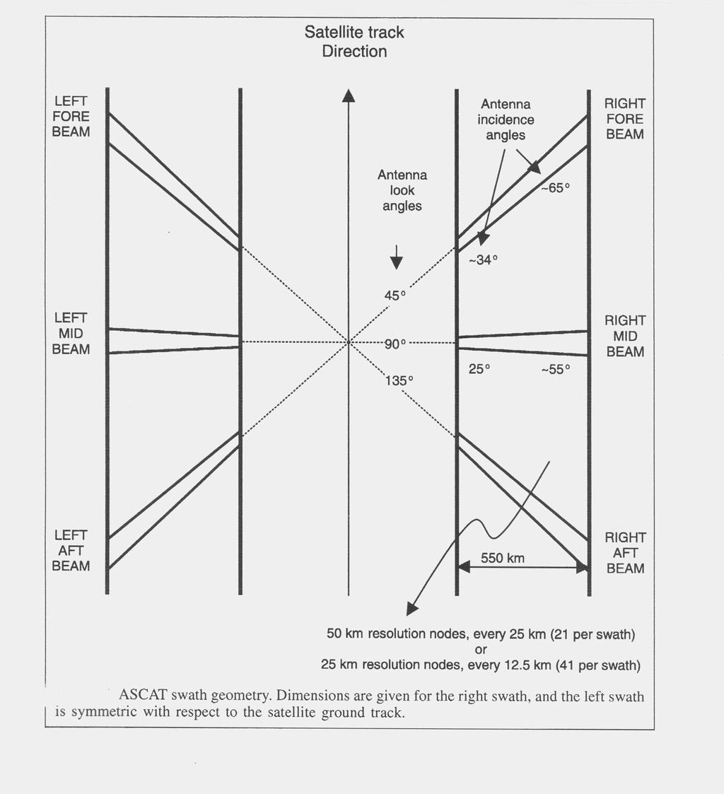
5 Over the 10 month interval from July 2008 to April 19, 2009, only three collocated rain events could be studied for this comparison. 1.Aug. 13, 2008, Buoy # 42035; Winds = 5 m/s from 209o Buoy # 42019; Winds = 6 m/s from 247o ASCAT Look Directions (degrees) relative to North: Forward: 240, Mid-Beam: 285; Aft: Aug. 15, 2008, Buoy # 42035; Winds = 9 m/s from 169o Buoy # 42019; Winds = 4 m/s from 192o ASCAT Look Directions (degrees) relative to North: Forward: 55, Mid-Beam: 100; Aft: Apr. 19, 2009, Buoy # 42035; Winds = 9 m/s from 150o Buoy # 42019; Winds = 5 m/s from 176o ASCAT Look Directions (degrees) relative to North: Forward: 30, Mid-Beam: 75; Aft: 120

6 Buoy > 5 m/s Buoy > 6 m/s
7 NOGAPS Wind Vectors (arrows) and Wind Speed (contours) 16Z 13 August, 2008 m/s
8 Each location is observed by ALL three beams: FWD,AFT and MID
9 Forward Beam Incidence Angles: (top) (middle) (bottom) Beam look direction: 240o Wind from 228o
10 Aft Beam Incidence Angles: (top) (middle) (bottom) Beam look direction: 330o Wind from 228o
11 Mid Beam Incidence Angles: (top) (middle) (bottom) Beam look direction: 285o Wind from 228o

12 Buoy > 9 m/s Buoy > 4 m/s
13 CFSR Wind Vectors (arrows) and Wind Speed (contours) 16Z 15 August, 2008 m/s
14 Forward Beam Look direction: 55o Wind from 180o Incidence angle 50-54o Aft Beam Look direction: 145o Wind from 180o Incidence angle 50-54o Mid Beam Look direction: 100o Wind from 180o Incidence angle 40-44o

15 Buoy > 9 m/s Buoy > 5 m/s
 16Z 19 April,")
16 MERRA Wind Vectors (arrows) and Wind Speed (contours) 16Z 19 April, 2009
17 Forward Beam Incidence Angles: (top) (bottom) Beam look direction: 30o Wind from 163o
18 Aft Beam Incidence Angles: (top) (bottom) Beam look direction: 120o Wind from 163o
19 Mid Beam Incidence Angles: (top) (Middle) (bottom) Beam look direction: 75o Wind from 163o
20 Table 1: Incidence angle Net Increase in NRCS - Aug. 13 event. Near KHG Fore Beam Aft Beam Mid Beam db increase in NRCS (up to 10 mm/hr) db db db db 2 db 2.5 db 3 db 3 db 2.5 db
21 Table 2: Net Increase in NRCS - Aug. 15 event. Near KHG Incidenc e angle Fore Beam Aft Beam Mid Beam db Increase In NRCS (up to 6 mm/hr) 3 db 3 db 2 db
22 Table 3: Net Increase in NRCS - Apr 19 event, Near KHG Incidence Angle Mid Beam db Increase In NRCS (up to 20 mm/hr db db db Fore Beam Aft Beam 3 db 3 db 4 db 4 db
23 The internal calibrations of ASCAT indicate that variations of Bo among the individual beams on each side of the satellite track are not greater than 0.2 db At this point it is worthwhile to consider the changes in NRCS as a function of wind speed, at various incidence angles. Recent work by Dr. Paul Hwang of the Naval Research Laboratory provides useful guidance in this regard. This can also be applied to interpreting the consequences of changes in NRCS induced by the rain splash effect.
24 Courtesy of Dr. Paul Hwang; A Note on the Ocean Surface Roughness Spectrum, Journal of Atmospheric and Oceanic Technology, Vol. 28, pp , March 2011 C-Band NRCS Theoretical Models, V and H Polarization

25 For Future Reference >> Ku-Band - Scatterometer mode: spectrometer Old: Hwang: 2008 New: Hwang 2011
26 The case studies presented here are in conditions where the buoy wind speeds were between 4 and 10 m/s. Applying Hwang s model; it can be seen that in the absence or rain: a) at an incidence angle of 30o a wind increase from 5 to 8 m/s produces an increase in NRCS of 2.5 db b) at an incidence angle of 50o a wind increase from 5 to 8 m/s produces an increase in NRCS of 3.2 db CONVERSELY We see from the results presented in Tables 1,2 and 3 that rainrates of 10 mm/hr that induce increases of NRCS from 2 to 4 db (depending on the incidence angle) are like to cause erroneously high wind estimates by about 60 % (estimating 8 m/s when the wind is actually 5 m/s). It is worth noting that while the sensitivity of NRCS to rainrate is lower for the smaller incidence, its net effect on wind error is the same as at high incidence angles (as per a) and b) above
27 SUMMARY Part I This experimental configuration lends itself to observing, simultaneously, the effects of rain on the different incidence and azimuth angles of the ASCAT scatterometer in a region where buoy wind measurements are also available. Under the specific conditions available here, we do not observe any sizeable differences in rain sensitivity between the different azimuth look directions, for a given incidence angle. The surface wind fields indicate some variability across the measurement region, which may account for some of the variability of the NRCS among cells where no rain is observed. Another source of variability is the inhomogeneity of the rain within each ASCAT cell (the beam filling problem).
28 SUMMARY Part II We find that the modification of the surface due to rain can cause substantial increases in backscatter, for wind speeds in the 4 10 m/s range. The change in backscatter is clearly a function of the incidence angle, but because the models for lower incidence angles (30 o) are less sensitive to wind, the consequences can be comparable. For these examples, substantial errors in wind speed were identified, and they were similar across incident angles. -> Harder to identify rain-related errors These findings indicate that the C band scatterometer can have substantial errors at low to moderate wind speeds and high rain rates (observed here from 6 to 20 mm/hr) -> Extra care should be taken when using ASCAT data for ocean forcing in tropical convergent zones.
29 Acknowledgements: for Programming Assistance: Steven Miller Research Assistant Hofstra University for Guidance regarding ASCAT performance in rain Dr. Ad Stoffelen
Satellite information on ocean vector wind from Scatterometer data. Giovanna De Chiara
 Satellite information on ocean vector wind from Scatterometer data Giovanna De Chiara Why is Scatterometer important? The scatterometer measures the ocean surface winds (ocean wind vector). Ocean surface
PRELIMINARY STUDY ON DEVELOPING AN L-BAND WIND RETRIEVAL MODEL FUNCTION USING ALOS/PALSAR
 PRELIMINARY STUDY ON DEVELOPING AN L-BAND WIND RETRIEVAL MODEL FUNCTION USING ALOS/PALSAR Osamu Isoguchi, Masanobu Shimada Earth Observation Research Center, Japan Aerospace Exploration Agency (JAXA) 2-1-1
On the Quality of HY-2A Scatterometer Winds
 On the Quality of HY-2A Scatterometer Winds W. Lin (ICM-CSIC) M. Portabella (ICM-CSIC) A. Stoffelen (KNMI) A. Verhoef (KNMI) Youguang Zhang (NSOAS) Mingsen Lin (NSOAS) Shuyan Lang (NSOAS) Juhong Zou (NSOAS)
SENSOR SYNERGY OF ACTIVE AND PASSIVE MICROWAVE INSTRUMENTS FOR OBSERVATIONS OF MARINE SURFACE WINDS
 SENSOR SYNERGY OF ACTIVE AND PASSIVE MICROWAVE INSTRUMENTS FOR OBSERVATIONS OF MARINE SURFACE WINDS N. Ebuchi Institute of Low Temperature Science, Hokkaido University, N19-W8, Kita-ku, Sapporo 060-0819,
Jackie May* Mark Bourassa. * Current affilitation: QinetiQ-NA
 Jackie May* Mark Bourassa * Current affilitation: QinetiQ-NA Background/Motivation In situ observations (ships and buoys) are used to validate satellite observations Problems with comparing data Sparseness
The Effects of Gap Wind Induced Vorticity, the ITCZ, and Monsoon Trough on Tropical Cyclogenesis
 The Effects of Gap Wind Induced Vorticity, the ITCZ, and Monsoon Trough on Tropical Cyclogenesis Heather M. Holbach and Mark A. Bourassa Center for Ocean-Atmospheric Prediction Studies Department of Earth,
THE QUALITY OF THE ASCAT 12.5 KM WIND PRODUCT
 THE QUALITY OF THE ASCAT 12.5 KM WIND PRODUCT Jur Vogelzang, Ad Stoffelen, Maria Belmonte, Anton Verhoef, and Jeroen Verspeek Royal Netherlands Meteorological Institute, Wilhelminalaan 10, 3732 GK, De
RapidScat wind validation report
 Ocean and Sea Ice SAF Technical Note SAF/OSI/CDOP2/KNMI/TEC/RP/228 25 and 50 km wind products (OSI-109) Anton Verhoef, Jur Vogelzang and Ad Stoffelen KNMI Version 1.1 March 2015 DOCUMENTATION CHANGE RECORD
Reprocessed QuikSCAT (V04) Wind Vectors with Ku-2011 Geophysical Model Function
 Wind Vectors with Ku-2011 Geophysical Model Function") Reprocessed QuikSCAT (V04) Wind Vectors with Ku-2011 Geophysical Model Function Lucrezia Ricciardulli and Frank Wentz Introduction In April 2011, we reprocessed the QuikSCAT ocean wind vectors using a
Reprocessed QuikSCAT (V04) Wind Vectors with Ku-2011 Geophysical Model Function Lucrezia Ricciardulli and Frank Wentz Introduction In April 2011, we reprocessed the QuikSCAT ocean wind vectors using a
Cross-Calibrating OSCAT Land Sigma-0 to Extend the QuikSCAT Land Sigma-0 Climate Record
 Cross-Calibrating OSCAT Land Sigma-0 to Extend the QuikSCAT Land Sigma-0 Climate Record David G. Long Department of Electrical and Computer Engineering Brigham Young University May 2013 0 Scatterometer
Review of Equivalent Neutral Winds and Stress
 Review of Equivalent Neutral Winds and Stress Mark A. Bourassa Center for Ocean-Atmospheric Prediction Studies, Geophysical Fluid Dynamics Institute & Department of Earth, Ocean and Atmospheric Science
Singularity analysis: A poweful technique for scatterometer wind data processing
 Singularity analysis: A poweful technique for scatterometer wind data processing M. Portabella (ICM-CSIC) W. Lin (ICM-CSIC) A. Stoffelen (KNMI) A. Turiel (ICM-CSIC) G. King (ICM-CSIC) A. Verhoef (KNMI)
Development of SAR-Derived Ocean Surface Winds at NOAA/NESDIS
 Development of SAR-Derived Ocean Surface Winds at NOAA/NESDIS Pablo Clemente-Colón, William G. Pichel, NOAA/NESDIS Frank M. Monaldo, Donald R. Thompson The Johns Hopkins University Applied Physics Laboratory
A. Bentamy 1, S. A. Grodsky2, D.C. Fillon1, J.F. Piollé1 (1) Laboratoire d Océanographie Spatiale / IFREMER (2) Univ. Of Maryland
 Laboratoire d Océanographie Spatiale / IFREMER (2) Univ. Of Maryland") Calibration and Validation of Multi-Satellite scatterometer winds A. Bentamy 1, S. A. Grodsky2, D.C. Fillon1, J.F. Piollé1 (1) Laboratoire d Océanographie Spatiale / IFREMER (2) Univ. Of Maryland Topics
Calibration and Validation of Multi-Satellite scatterometer winds A. Bentamy 1, S. A. Grodsky2, D.C. Fillon1, J.F. Piollé1 (1) Laboratoire d Océanographie Spatiale / IFREMER (2) Univ. Of Maryland Topics
The Ice Contamination Ratio Method: Accurately Retrieving Ocean Winds Closer to the Sea Ice Edge While Eliminating Ice Winds
 The Ice Contamination Ratio Method: Accurately Retrieving Ocean Winds Closer to the Sea Ice Edge While Eliminating Ice Winds David Long Department of Electrical and Computer Engineering Brigham Young University
Evaluation of the HY-2A Scatterometer wind quality
 Evaluation of the HY-2A Scatterometer wind quality Wenming Lin, Marcos Portabella, Antonio Turiel ICM-CSIC Ad Stoffelen, Anton Verhoef KNMI Qingtao Song, Xingwei Jiang NOSAS Dudely B. Chelton OSU Typhoon
Climate-Quality Intercalibration of Scatterometer Missions
 Climate-Quality Intercalibration of Scatterometer Missions Lucrezia Ricciardulli and Frank Wentz Remote Sensing Systems, Santa Rosa, California IOVWST meeting Sapporo, Japan, May 2016 Photo Courtesy: 1
SMAP Radiometer-Only Tropical Cyclone Size and Strength
 SMAP Radiometer-Only Tropical Cyclone Size and Strength Alexander Fore, Simon Yueh, Wenqing Tang, Bryan SCles, Akiko Hayashi Jet Propulsion Laboratory, California InsCtute of Technology 218 California
Quantifying variance due to temporal and spatial difference between ship and satellite winds
 JOURNAL OF GEOPHYSICAL RESEARCH, VOL. 116,, doi:10.1029/2010jc006931, 2011 Quantifying variance due to temporal and spatial difference between ship and satellite winds Jackie C. May 1,2,3 and Mark A. Bourassa
Coastal Scatterometer Winds Working Group
 Coastal Scatterometer Winds Working Group IOVWST Meeting 2015 Portland, Oregon, USA Melanie Fewings Julia Figa Saldaña Bryan Stiles Steve Morey Dmitry Dukhovskoy Larry O Neill if you want to be added to
SIMON YUEH, WENQING TANG, ALEXANDER FORE, AND JULIAN CHAUBELL JPL-CALTECH, PASADENA, CA, USA GARY LAGERLOEF EARTH AND SPACE RESEARCH, SEATTLE, WA, US
 Applications of L-Band Scatterometry and Radiometry to Aquarius and SMAP SIMON YUEH, WENQING TANG, ALEXANDER FORE, AND JULIAN CHAUBELL JPL-CALTECH, PASADENA, CA, USA GARY LAGERLOEF EARTH AND SPACE RESEARCH,
SeaWinds wind Climate Data Record validation report
 Ocean and Sea Ice SAF Technical Note SAF/OSI/CDOP2/KNMI/TEC/RP/221 SeaWinds wind Climate Data Record validation report 25 and 50 km wind products (OSI-151) Anton Verhoef, Jur Vogelzang and Ad Stoffelen
An algorithm for Sea Surface Wind Speed from MWR
 An algorithm for Sea Surface Wind Speed from MWR Carolina Tauro 1, Yazan Heyazin 2, María Marta Jacob 1, Linwood Jones 1 1 Comisión Nacional de Actividades Espaciales (CONAE) 2 Central Florida Remote Sensing
Synthetic Aperture Radar imaging of Polar Lows
 Oslo Polar Low workshop 21-22 May 2012 Extended abstract Synthetic Aperture Radar imaging of Polar Lows Birgitte Furevik, Gunnar Noer and Johannes Röhrs met.no Forecasting polar lows is to a large degree
Wind Stress Working Group 2015 IOVWST Meeting Portland, OR
 Wind Stress Working Group 2015 IOVWST Meeting Portland, OR Summary of Research Topics, Objectives and Questions James B. Edson University of Connecticut SPURS Mooring, Farrar, WHOI Background Motivation
Towards a consolidated wind reference for assessing scatterometer high and extreme-force wind capabilities
 Towards a consolidated wind reference for assessing scatterometer high and extreme-force wind capabilities Federica Polverari1, Wenming Lin2, Joe Sapp3, Marcos Portabella1, Ad Stoffelen4, Alexis Mouche5,
CHANGE OF THE BRIGHTNESS TEMPERATURE IN THE MICROWAVE REGION DUE TO THE RELATIVE WIND DIRECTION
 JP4.12 CHANGE OF THE BRIGHTNESS TEMPERATURE IN THE MICROWAVE REGION DUE TO THE RELATIVE WIND DIRECTION Masanori Konda* Department of Geophysics, Graduate School of Science, Kyoto University, Japan Akira
High Resolution Sea Surface Roughness and Wind Speed with Space Lidar (CALIPSO)
") High Resolution Sea Surface Roughness and Wind Speed with Space Lidar (CALIPSO) Yongxiang Hu NASA Langley Research Center Carl Weimer Ball Aerospace Corp. 1 CALIPSO Mission Overview CALIPSO seeks to improve
High Resolution Sea Surface Roughness and Wind Speed with Space Lidar (CALIPSO) Yongxiang Hu NASA Langley Research Center Carl Weimer Ball Aerospace Corp. 1 CALIPSO Mission Overview CALIPSO seeks to improve
Satellite Observations of Equatorial Planetary Boundary Layer Wind Shear
 Satellite Observations of Equatorial Planetary Boundary Layer Wind Shear David Halpern and Michael Garay NASA / California Institute of Technology Jet Propulsion Laboratory Pasadena, California, USA Thanks
Validation of 12.5 km and Super-High Resolution (2-5 km)
") Coastal and Orographic Wind Analyses from High Resolution QuikSCAT and SeaWinds Measurements M.H. Freilich, COAS/OSU D.B. Chelton, COAS/OSU D.G. Long, BYU Clive Dorman, SIO Barry Vanhoff, COAS/OSU OVWST
Coastal and Orographic Wind Analyses from High Resolution QuikSCAT and SeaWinds Measurements M.H. Freilich, COAS/OSU D.B. Chelton, COAS/OSU D.G. Long, BYU Clive Dorman, SIO Barry Vanhoff, COAS/OSU OVWST
Aquarius Sca+erometer Calibra3on
 Aquarius Sca+erometer Calibra3on Fore, A., Neumann, G., Freedman, A., Chaubell, M., Tang, W., Hayashi, A., and Yueh, S. 217 California Ins3tute of Technology, Government Sponsorship acknowledged Aquarius
Dynamics and variability of surface wind speed and divergence over mid-latitude ocean fronts
 Dynamics and variability of surface wind speed and divergence over mid-latitude ocean fronts Larry O Neill 1, Tracy Haack 2, and Simon de Szoeke 1 1 Oregon State University, Corvallis, OR 2 Naval Research
Walker Circulation and El Niño / La Niña Sea Surface Temperature, Rainfall, and Zonal Wind
 Walker Circulation and El Niño / La Niña Sea Surface Temperature, Rainfall, and Zonal Wind David Halpern NASA / California Institute of Technology Jet Propulsion Laboratory Pasadena, CA 91109, USA Contents
Combining wind and rain in spaceborne scatterometer observations: modeling the splash effects in the sea surface backscattering coefficient
 Combining wind and rain in spaceborne scatterometer observations: modeling the splash effects in the sea surface backscattering coefficient F. Polverari (1,2,4), F. S. Marzano (1,2), L. Pulvirenti (3,1),
Scales of Atmospheric Motion Scale Length Scale (m) Time Scale (sec) Systems/Importance Molecular (neglected)
 Time Scale (sec) Systems/Importance Molecular (neglected)") Supplement Wind, Fetch and Waves Scales of Atmospheric Motion Scale Length Scale (m) Time Scale (sec) Systems/Importance Molecular 10-7 - 10-2 10-1 (neglected) Coriolis not important Turbulent 10-2 10
Supplement Wind, Fetch and Waves Scales of Atmospheric Motion Scale Length Scale (m) Time Scale (sec) Systems/Importance Molecular 10-7 - 10-2 10-1 (neglected) Coriolis not important Turbulent 10-2 10
High resolution wind retrieval for SeaWinds
 High resolution wind retrieval for SeaWinds David G. Long and Jeremy B. Luke Brigham Young University, 459 Clyde Building, Provo, UT 84602, USA ABSTRACT The SeaWinds instrument on the QuikSCAT satellite
Deborah K. Smith, Frank J. Wentz, and Carl A. Mears Remote Sensing Systems
 JP 4.9 RESULTS OF QUIKSCAT HIGH WIND DATA VALIDATION Deborah K. Smith, Frank J. Wentz, and Carl A. Mears Remote Sensing Systems ABSTRACT Traditional validation of satellite-derived winds includes comparison
On the Interpretation of Scatterometer Winds near Sea Surface Temperature Fronts
 On the Interpretation of Scatterometer Winds near Sea Surface Temperature Fronts Jim Edson University of Connecticut Amanda Plagge & Doug Vandemark University of New Hampshire IOVWST Meeting Utrecht, NL
SATELLITE wind scatterometer instruments are active remote
 2340 IEEE JOURNAL OF SELECTED TOPICS IN APPLIED EARTH OBSERVATIONS AND REMOTE SENSING, VOL. 10, NO. 5, MAY 2017 Improved Use of Scatterometer Measurements by Using Stress-Equivalent Reference Winds Jos
Characterization of ASCAT measurements based on buoy and QuikSCAT wind vector observations
 Ocean Sci., 4, 265 274, 2008 Author(s) 2008. This work is distributed under the Creative Commons Attribution 3.0 License. Ocean Science Characterization of ASCAT measurements based on buoy and QuikSCAT
Offshore wind resource mapping in Europe from satellites
 Offshore wind resource mapping in Europe from satellites Charlotte Bay Hasager Seminar at University of Auckland, Dept. of Physics 1 April 2015 Content DTU Wind Energy Offshore wind turbines New European
Wind Observations EUMETSAT OSI SAF EUMETSAT NWP SAF EU CMEMS OSI TAC EU MyWave EU NORSEWInD ESA esurge ESA GlobCurrent ESA Aeolus
 Wind Observations Ad.Stoffelen@knmi.nl EUMETSAT OSI SAF EUMETSAT NWP SAF EU CMEMS OSI TAC EU MyWave EU NORSEWInD ESA esurge ESA GlobCurrent ESA Aeolus Overview Spatially consistent observed winds are available
The RSS WindSat Version 7 All-Weather Wind Vector Product
 2010 International Ocean Vector Winds Meeting Barcelona, Spain May 18 20, 2010 The RSS WindSat Version 7 All-Weather Wind Vector Product Thomas Meissner Lucrezia Ricciardulli Frank Wentz Outline 1. Overview:
Institut Français pour la Recherche et l Exploitation de la MER
 Institut Français pour la Recherche et l Exploitation de la MER Laboratoire d'océanographie Physique et Spatiale Satellites Interface Air- Mer June 2017 Document IFREMER/LOPS/Long Time Series Satellite
Validation of 12.5 km Resolution Coastal Winds. Barry Vanhoff, COAS/OSU Funding by NASA/NOAA
 Validation of 12.5 km Resolution Coastal Winds Barry Vanhoff, COAS/OSU Funding by NASA/NOAA Outline Part 1: Determining empirical land mask Characterizing σ 0 near coast Part 2: Wind retrieval using new
HIGH RESOLUTION WIND RETRIEVAL FOR SEAWINDS ON QUIKSCAT. Jeremy B. Luke. A thesis submitted to the faculty of. Brigham Young University
 HIGH RESOLUTION WIND RETRIEVAL FOR SEAWINDS ON QUIKSCAT by Jeremy B. Luke A thesis submitted to the faculty of Brigham Young University in partial fulfillment of the requirements for the degree of Master
The Air-Sea Interaction. Masanori Konda Kyoto University
 2 The Air-Sea Interaction Masanori Konda Kyoto University 2.1 Feedback between Ocean and Atmosphere Heat and momentum exchange between the ocean and atmosphere Atmospheric circulation Condensation heat
OCEAN vector winds from the SeaWinds instrument have
 IEEE GEOSCIENCE AND REMOTE SENSING LETTERS, VOL. 6, NO. 3, JULY 2009 413 Coastal Validation of Ultra-High Resolution Wind Vector Retrieval From QuikSCAT in the Gulf of Maine A. M. Plagge, Student Member,
SAR images and Polar Lows
 SAR images and Polar Lows Gunnar Noer, Birgitte Furevik, Johannes Röhrs Observing polar lows in 2012: AVHRR Polar orbiting satellite imagery Primary source of info Observations at cloud tops Synoptic observations
ERS-1/2 Scatterometer new products: mission reprocessing and data quality improvement
 ERS-1/2 Scatterometer new products: mission reprocessing and data quality improvement Giovanna De Chiara (1), Raffaele Crapolicchio (1), Pascal Lecomte (2) (1) Serco SpA Via Sciadonna 22-24 Frascati (Roma),
SeaWinds Validation with Research Vessels
 1 SeaWinds Validation with Research Vessels Mark A. Bourassa 1, David M. Legler 1,, James J. O'Brien 1, and Shawn R. Smith 1 Abstract. The accuracy of vector winds from the SeaWinds scatterometer on the
Assimilation of Scatterometer Winds at Météo-France
 Assimilation of Scatterometer Winds at Météo-France Christophe Payan, Nathalie Boullot (1), Dominique Mékies (2) (1) CNRM and GAME, Météo-France and CNRS (2) LACy, La Réunion University, CNRS and Météo-France
Aquarius Wind Speed Retrievals and Implica6ons for SMAP Ocean Vector Winds
 Aquarius Wind Speed Retrievals and Implica6ons for SMAP Ocean Vector Winds Alex Fore, Simon Yueh, Wenqing Tang, Julian Chaubell, Gregory Neumann, Akiko Hayashi, and Adam Freedman 214 California Ins6tute
Introduction EU-Norsewind
 Satellite winds in EU-Norsewind Charlotte Bay Hasager, Risø DTU, Denmark Alexis Mouche, CLS, France Merete Badger, Poul Astrup & Morten Nielsen, Risø DTU, Denmark Romain Husson, ESA Introduction EU-Norsewind
Generalized Wave-Ray Approach for Propagation on a Sphere and Its Application to Swell Prediction
 Generalized Wave-Ray Approach for Propagation on a Sphere and Its Application to Swell Prediction D. Scott 1, D. Resio 2, and D. Williamson 1 1. & Associates 2. Coastal Hydraulic Laboratory, U.S. Army
Analyses of Scatterometer and SAR Data at the University of Hamburg
 Analyses of Scatterometer and SAR Data at the University of Hamburg Wind, Waves, Surface Films and Rain ГАДЕ, Мартин Хорстович (aka Martin Gade) Institut für Meereskunde, Universität Hamburg, Германия
Ocean Waves and Surf Forecasting: Wave Climate and Forecasting
 Overview Ocean Waves and Surf Forecasting: Wave Climate and Forecasting Ocean regions Characterizing and describing ocean waves Wave theory, propagation, and dispersion Refraction, shadowing, and bathymetry
JET PROPULSION LABORATORY INTEROFFICE MEMORANDUM
 JET PROPULSION LABORATORY INTEROFFICE MEMORANDUM 3348-99-008 June 16, 1999 To: From: CC: Subject: Philip S. Callahan Young-Joon Kim SAPIENT, SVT Validation of the NOAA Processor through a comparison with
Sentinel-1A Ocean Level-2 Products Validation Strategy
 Sentinel-1A Ocean Level-2 Products Validation Strategy Sentinel-1 Mission Performance Centre ESL L2 Team and Ocean Data Lab G.Hajduch (1), A.Mouche (2), P.Vincent (1), R.Husson (1), H.Johnsen (3), F.Collard
OPERATIONS SEAFARER CERTIFICATION GUIDANCE NOTE SA MARITIME QUALIFICATIONS CODE. Deck: Chart Work
 Page 1 of 6 Compiled by Approved by Chief Examiner Syllabus Committee: 26 February 2013 OPERATIONS SEAFARER CERTIFICATION GUIDANCE NOTE SA MARITIME QUALIFICATIONS CODE Deck: Chart Work Page 2 of 6 COLUMN
Section 6. The Surface Circulation of the Ocean. What Do You See? Think About It. Investigate. Learning Outcomes
 Chapter 5 Winds, Oceans, Weather, and Climate Section 6 The Surface Circulation of the Ocean What Do You See? Learning Outcomes In this section, you will Understand the general paths of surface ocean currents.
On the quality of high resolution scatterometer winds
 JOURNAL OF GEOPHYSICAL RESEARCH, VOL. 116,, doi:10.1029/2010jc006640, 2011 On the quality of high resolution scatterometer winds Jur Vogelzang, 1 Ad Stoffelen, 1 Anton Verhoef, 1 and Julia Figa Saldaña
Underwater measurement of photosynthetically active radiation
 Underwater measurement of photosynthetically active radiation Mark Blonquist, Damon Nitzel, and Bruce Bugbee Apogee Instruments, Inc., Logan, Utah Introduction Quantum sensors (photosynthetically active
Algorithm Theoretical Basis Document for the OSI SAF wind products. Ocean and Sea Ice SAF
 Algorithm Theoretical Basis Document for the OSI SAF wind products Ocean and Sea Ice SAF Version 1.0 August 2012 DOCUMENT SIGNATURE TABLE Prepared by : Name Date Signature O&SI SAF Project Aug 2012 Approved
Hui Wang, Mike Young, and Liming Zhou School of Earth and Atmospheric Sciences Georgia Institute of Technology Atlanta, Georgia
 Water Cycle between Ocean and Land and Its Influence on Climate Variability over the South American-Atlantic Regions as Determined by SeaWinds Scatterometers Rong Fu Hui Wang, Mike Young, and Liming Zhou
MISR CMVs. Roger Davies and Aaron Herber Physics Department
 MISR CMVs Roger Davies and Aaron Herber Physics Department Acknowledgements: MISR Science and Data Processing Team (especially Catherine Moroney and Mike Garay) From the AGU Fall Meeting 2009 MISR and
THE SEAWINDS scatterometer was flown twice, once on
 IEEE TRANSACTIONS ON GEOSCIENCE AND REMOTE SENSING 1 Land-Contamination Compensation for QuikSCAT Near-Coastal Wind Retrieval Michael P. Owen and David G. Long, Fellow, IEEE Abstract The QuikSCAT scatterometer
Does direct impact of SST on short wind waves matter for scatterometry?
 GEOPHYSICAL RESEARCH LETTERS, VOL. 39,, doi:10.1029/2012gl052091, 2012 Does direct impact of SST on short wind waves matter for scatterometry? Semyon A. Grodsky, 1 Vladimir N. Kudryavtsev, 2 Abderrahim
The Cross-Calibrated Multi-Platform (CCMP) Ocean Vector Wind Analysis (V2.0)
 Ocean Vector Wind Analysis (V2.0)") The Cross-Calibrated Multi-Platform (CCMP) Ocean Vector Wind Analysis (V2.0) Carl A. Mears, L. Ricciardulli, J. Scott and F. J. Wentz Remote Sensing Systems Ross Hoffman, S. Mark Leidner Robert Atlas Atmospheric
The Cross-Calibrated Multi-Platform (CCMP) Ocean Vector Wind Analysis (V2.0) Carl A. Mears, L. Ricciardulli, J. Scott and F. J. Wentz Remote Sensing Systems Ross Hoffman, S. Mark Leidner Robert Atlas Atmospheric
Using several data sources for offshore wind resource assessment
 Author manuscript, published in ", Copenhagen : Denmark (2005)" Ben Ticha M. B., Ranchin T., Wald L., Using several data sources for offshore wind resource assessment, 2005, Using several data sources
SEA SURFACE TEMPERATURE RETRIEVAL USING TRMM MICROWAVE IMAGER SATELLITE DATA IN THE SOUTH CHINA SEA
 SEA SURFACE TEMPERATURE RETRIEVAL USING TRMM MICROWAVE IMAGER SATELLITE DATA IN THE SOUTH CHINA SEA Mohd Ibrahim Seeni Mohd and Mohd Nadzri Md. Reba Faculty of Geoinformation Science and Engineering Universiti
Eastern Equatorial Pacific
 Overview The is the region of open ocean directly south of Mexico and Central America (between approximately 4 o to 16 o N, and 85 o to 105 o W) (Figure 1). Major bathymetric features include Guatemala
WIND BIAS CORRECTION GUIDE. General. Introduction. Ad Stoffelen and Jur Vogelzang KNMI. Version 1.1 Apr 2014
 WIND BIAS CORRECTION GUIDE Ad Stoffelen and Jur Vogelzang KNMI Version 1.1 Apr 2014 General This document is written for all users of Numerical Weather Prediction Satellite Application Facility (NWP SAF)
Scatterometer-Based Assessment of 10-m Wind Analyses from the Operational ECMWF and NCEP Numerical Weather Prediction Models
 FEBRUARY 2005 C H E L T O N A N D F R E I L I C H 409 Scatterometer-Based Assessment of 10-m Wind Analyses from the Operational ECMWF and NCEP Numerical Weather Prediction Models DUDLEY B. CHELTON AND
ON THE USE OF DOPPLER SHIFT FOR SAR WIND RETRIEVAL
 ON THE USE OF DOPPLER SHIFT FOR SAR WIND RETRIEVAL K-F. Dagestad 1, A. Mouche 2, F. Collard 2, M. W. Hansen 1 and J. Johannessen 1 (1) Nansen Environmental and Remote Censing Center, Thormohlens gt 47,
Azimuthal variations of X-band medium grazing angle sea clutter
 Azimuthal variations of X-band medium grazing angle sea clutter Z. Guerraou (1), S. Angelliaume (1), C.-A. Guérin (2) and L. Rosenberg (3) (1) : ONERA, the French Aerospace Lab France (2) : University
First six months quality assessment of HY-2A SCAT wind products using in situ measurements
 Acta Oceanol. Sin., 2013, Vol. 32, No. 11, P. 27-33 DOI: 10.1007/s13131-013-0374-5 http://www.hyxb.org.cn E-mail: hyxbe@263.net First six months quality assessment of HY-2A SCAT wind products using in
Advancements in scatterometer wind processing
 Advancements in scatterometer wind processing Ad.Stoffelen@knmi.nl Marcos Portabella Anton Verhoef Jeroen Verspeek Jur Vogelzang scat@knmi.nl www.knmi.nl/scatterometer Scatterometer work The scatterometer
The Setting - Climatology of the Hawaiian Archipelago. Link to Video of Maui Waves
 The Setting - Climatology of the Hawaiian Archipelago Link to Video of Maui Waves What caused this week s weather? What caused this weekend s weather? Today s Objective: Provide overview and description
OAFlux: global, 0.25, daily
 Including ASCAT in OAFlux Global Vector Wind Analysis (1987 present) with programming support from Dr. Xiangze Jin July 1987 OAFlux: global, 0.25, daily QuikSCAT AMSRE SSMI (F08, F10, F11, F13, F14, F15,
Impact of fine-scale wind stress curl structures on coastal upwelling dynamics : The Benguela system as a case of study.
 IOVWST Meeting May 21, 2015, Portland (OR) Impact of fine-scale wind stress curl structures on coastal upwelling dynamics : The Benguela system as a case of study. Fabien Desbiolles1,2, Bruno Blanke1,
ValidatingWindProfileEquationsduringTropicalStormDebbyin2012
 Global Journal of Researches in Engineering: e Civil And Structural Engineering Volume 4 Issue Version. Year 24 Type: Double Blind Peer Reviewed International Research Journal Publisher: Global Journals
Air-Sea Interaction Spar Buoy Systems
 DISTRIBUTION STATEMENT A: Distribution approved for public release; distribution is unlimited Air-Sea Interaction Spar Buoy Systems Hans C. Graber CSTARS - University of Miami 11811 SW 168 th Street, Miami,
Imprints of Coastal Mountains on Ocean Circulation and Variability
 Imprints of Coastal Mountains on Ocean Circulation and Variability Shang-Ping Xie 1 with C.-H. Chang 1, W. Zhuang 2, N. Schneider 1, J. Small 3, B. Taguchi 4, and H. Sasaki 4 1 IPRC, University of Hawaii
Wind Direction Analysis over the Ocean using SAR Imagery
 Journal of Information & Computational Science 5: 1 (2008) 223-231 Available at http: www.joics.com Wind Direction Analysis over the Ocean using SAR Imagery Kaiguo Fan a,b,, Weigen Huang a, Mingxia He
Constraining a global, eddying, ocean and sea ice model with scatterometer data
 Constraining a global, eddying, ocean and sea ice model with scatterometer data D. Menemenlis, H. Zhang, D. Moroni, and S. Hristova-Veleva IOVWST, Utrecht, Netherlands, 13 June 2012 QuikSCAT GRACE =? Jason
Determination of the Spatial Variation of the Atmosphere and Ocean Wave Fields in Extremely Light Wind Regimes
 Determination of the Spatial Variation of the Atmosphere and Ocean Wave Fields in Extremely Light Wind Regimes Gennaro H. Crescenti U.S. Dept. Commerce / NOAA Air Resources Laboratory Field Research Division
Appendix E Cat Island Borrow Area Analysis
 Appendix E Cat Island Borrow Area Analysis ERDC/CHL Letter Report 1 Cat Island Borrow Area Analysis Multiple borrow area configurations were considered for Cat Island restoration. Borrow area CI1 is located
THE POLARIMETRIC CHARACTERISTICS OF BOTTOM TOPOGRAPHY RELATED FEATURES ON SAR IMAGES
 THE POLARIMETRIC CHARACTERISTICS OF BOTTOM TOPOGRAPHY RELATED FEATURES ON SAR IMAGES Taerim Kim Professor, Ocean System Eng. Dept. Kunsan University Miryong Dong San 68, Kunsan, Jeonbuk, Korea, trkim@kunsan.ac.kr
Wednesday, September 27, 2017 Test Monday, about half-way through grading. No D2L Assessment this week, watch for one next week
 Wednesday, September 27, 2017 Test Monday, about half-way through grading No D2L Assessment this week, watch for one next week Homework 3 Climate Variability (due Monday, October 9) Quick comment on Coriolis
Emission Inventory Evaluation Using DISCOVER-AQ Aircraft Data
 Emission Inventory Evaluation Using DISCOVER-AQ Aircraft Data Gary McGaughey, David Allen (PI) and Elena McDonald-Buller (co-pi) Center for Energy and Environmental Resources The University of Texas at
Lecture 14. Heat lows and the TCZ
 Lecture 14 Heat lows and the TCZ ITCZ/TCZ and heat lows While the ITCZ/TCZ is associated with a trough at low levels, it must be noted that a low pressure at the surface and cyclonic vorticity at 850 hpa
Statistics of wind and wind power over the Mediterranean Sea
 Conférence Méditerranéenne Côtière et Maritime EDITION 2, TANGER, MAROC (2011) Coastal and Maritime Mediterranean Conference Disponible en ligne http://www.paralia.fr Available online Statistics of wind
The Sea surface KInematics Multiscale (SKIM)
") The Sea surface KInematics Multiscale () proposal for ESA EE9 the team : https://www.facebook.com/4ee9 http://tinyurl.com/onrg http://www.umr-lops.fr/projets/projets-actifs/ 14 years of Doppler oceanography:
The Sea surface KInematics Multiscale () proposal for ESA EE9 the team : https://www.facebook.com/4ee9 http://tinyurl.com/onrg http://www.umr-lops.fr/projets/projets-actifs/ 14 years of Doppler oceanography:
An Atlas of Oceanic Internal Solitary Waves (May 2002) by Global Ocean Associates Prepared for the Office of Naval Research - Code 322PO
 by Global Ocean Associates Prepared for the Office of Naval Research - Code 322PO") Overview is located in the western Pacific Ocean along the west side of the Philippines (between approximately 5 o and 11 o N. latitude and 117 o and 123 o E. longitude). It is a deepwater sea, roughly
Overview is located in the western Pacific Ocean along the west side of the Philippines (between approximately 5 o and 11 o N. latitude and 117 o and 123 o E. longitude). It is a deepwater sea, roughly
Wind scatterometers, the tropics and the ECMWF model
 Wind scatterometers, the tropics and the ECMWF model Ad.Stoffelen@knmi.nl Leader active sensing group R&D satellite observations KNMI Jur Vogelzang, Anton Verhoef, Maria Belmonte, Jeroen Verspeek, Jos
Geophysical Model Functions for the Retrieval of Ocean Surface Winds
 Geophysical Model Functions for the Retrieval of Ocean Surface Winds Donald R. Thompson and Frank M. Monaldo Johns Hopkins University Applied Physics Laboratory 11100 Johns Hopkins Road, Laurel, MD 20708
The technical support for global validation of ERS Wind and Wave Products at ECMWF
 The technical support for global validation of ERS Wind and Wave Products at ECMWF (July 27 - June 28) November 28 Authors: Saleh Abdalla and Hans Hersbach Final report for ESA contract 291/7/I-EC Series:
IMPROVED OIL SLICK IDENTIFICATION USING CMOD5 MODEL FOR WIND SPEED EVALUATION ON SAR IMAGES
 IMPROVED OIL SLICK IDENTIFICATION USING CMOD5 MODEL FOR WIND SPEED EVALUATION ON SAR IMAGES H.KHENOUCHI & Y. SMARA University of Sciences and Technology Houari Boumediene (USTHB). Faculty of Electronics
Application of OSVW to Determine Wave Generation Areas
 Application of OSVW to Determine Wave Generation Areas Joe Sienkiewicz, NOAA Ocean Prediction Center Greg McFadden, IMSG Special thanks to: Keith Brill, Hydrometeorological Prediction Center Scott Jacobs,