Synthetic Aperture Radar imaging of Polar Lows
|
|
|
- Godfrey Malone
- 5 years ago
- Views:
Transcription
1 Oslo Polar Low workshop May 2012 Extended abstract Synthetic Aperture Radar imaging of Polar Lows Birgitte Furevik, Gunnar Noer and Johannes Röhrs met.no Forecasting polar lows is to a large degree based on satellite observations from NOAA Advanced very high resolution radiometer (AVHRR) and from Scatterometer winds in addition to synoptic observations and numerical models. Synthetic Aperture Radar brings higher resolution compared to these other remotely sensed sources of ocean wind such as the scatterometer data and passive microwave window channel wind products. We assess the added value in polar lows of SAR and of increased resolution in observed ocean wind information in general with respect to 1. Wind information content increase with resolution 2. Information availability close to coast We have used the standard method for wind retrieval from SAR before gridding the wind fields and SAR backscatter images to the STARS-DAT grid. The Envisat ASAR images are calibrated to obtain the normalised radar cross section values (NRCS) and using external information for wind directions, wind speed is estimated from the scatterometer C-band geophysical model function CMOD5 1. Wind direction input is taken from the met.no hindcast archive NORA10 (Reistad et al., 2011) based on HIRLAM with 10km spatial resolution. However, wind directions from scatterometer instead of a numerical model generally improve the SAR wind fields. When co-locations of ASCAT and ASAR WSM exists with a time difference of less than +/- 2hours, wind retrieval is also performed with these wind directions. The analysis presented is work in progress, but describe two case studies to illustrate the possibilities and challenges of using SAR. Case I: SAR early detection of a polar low? From the AVHRR from 10 utc (Figure 1a), a fully developed polar low further northwest can be clearly identified, but in the area of 71N 012E, only an indeterminate cloud structure can be seen. From the actual 09z analysis this was indicated as a back bent occlusion to the rear of the passing synoptic low. Not until two hours later (Figure 1b), a first indication can be seen from the AVHRR; a feeble eye barely visible, but the waves in the cirrus to the west of this is an early warning that something is about to happen. At 14 utc (Figure 1c), a more clear signature in the AVHRR appears, the eye still only barely visible, but the cloud structures now have the distinct signature of a polar low. At 20utc (Figure 1d) the polar low is showing the typical cyclonic signature, with a cirrus shield with cloud tops at -52 to 55 C to the north of the center, and a cloud band with gradually lesser vertical extent leading in towards the center around the western part of the low. An ASAR image from 10:13utc (Figure 2a) displays a well defined area of stronger wind (with a magnitude of 28 m/s) to the west of a sharp shear zone at 71N, 12E. A shear zone of just a few km is separating this area from a more tranquil area to the east with winds of 15 m/s, and then even further 1

. But in spite of this, several interesting features can be seen.")


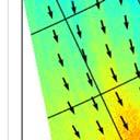
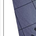
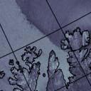
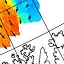
2 east, a signature similar to what could be expected from the eye of a polar low, with calm winds of magnitude of 5 m/s. The wind directions for this image are taken from an ASCAT passage almost 1.5 hours earlier (08:51utc) but the directions fit quite well with the wind signatures in the SAR image and the resulting wind speeds are believed to be quite good in this case. Unfortunately there are no ASCAT passage to cover the ASAR image in the evening at 20:06 (Figure 2b). But in spite of this, several interesting features can be seen. The most prominent is the sharp increase in wind in the northern sector of the low. The increase from a northeasterly fresh breeze at 12m/s to more than 25 m/s (absolute value is uncertain due to the model wind directions not aligned with the wind signatures in the SAR image) occurs in a zone of less that 3 km. The speed of propagation of the low was around 2,4 m/s at the time, which means that this increase would have taken approximately 20 minutes. Another interesting aspect is the location of the strongest wind speed. This is not, as normally observed in the western quadrant, but rather north of the center, following the area of strongest convection and highest vertical extent of the cloud mass. However, since the wind directions are perhaps some degrees mis-alinged with the wind streaks in the SAR image north and west of the polar low center, this result is uncertain. a) b)
 10utc, b) 12utc, b) 14utc and d) 20utc on November")
 ASAR surface wind signature from the incipient stages of")

.")


 shows the maximum wind area (bright area)")

 with lower winds in the")


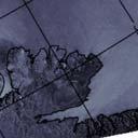
3 c) d) Figure 1: AVHRR ch.4 image from a) 10utc, b) 12utc, b) 14utc and d) 20utc on November 18, Figure 2: a) ASAR surface wind signature from the incipient stages of a polar low, 18. November 2008 at 10UTC. Black arrows are wind directions from ASCAT 08:51utc. b) ASAR surface wind signature at 20:06utc using model wind directions from NORA10 (black arrows). Following the impressions of the AVHRR, this polar low would probably first have been suspected at the 14 utc image, and not be identified with certainty until the 20utc image, by which time it would be too late for an effective warning. If the 10utc SAR image had been more readily available to the forecaster, even with a three hour delay time it would have proven a very useful additional source of information, and would most likely have had an impact on the timing and focus of the weather warnings on this polar low. Case 2: Honningsvåg polar low The AVHRR image from January 7, 2009 at 9utc (Figure 3) shows the visual (IR) appearance overlaid synoptic wind observations from a mature polar low as it hits the community of Honningsvaag at the coast of Northern Norway. The ASAR image (Figure 4a) shows the maximum wind area (bright area) coincident the clouds in the AVHRR image and a very sharp front to the low wind area. An eye is also visible. The highest wind speed is about 23 m/s based on this SAR image and ASCAT directions from 08:18utc (Figure 4b) with lower winds in the area east of the front of about 10m/s. The synoptic observations seen in image 3 suggests that there are large differences in wind magnitude and direction from different parts of the low. Only by inspecting the SAR image in figure 4 can the sharpness of the transition zone be fully appreciated. In this case, the gradient of about 13m/s happens over a distance of about 1km. The low was slow moving compared to the typical speed of propagation for polar lows which is found to be 8 to 13 m/s. Given a typical speed of propagation of 10 m/s, and an orientation of the shear zone at a steeper angle to the direction of movement of the low, this change from breeze to storm can take from 1 to 15 minutes. Tales of such rapid changes in wind are frequently b)

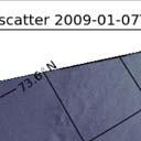
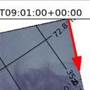
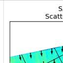
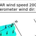
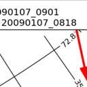
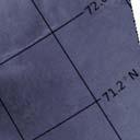
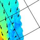
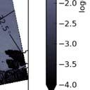
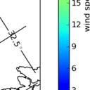
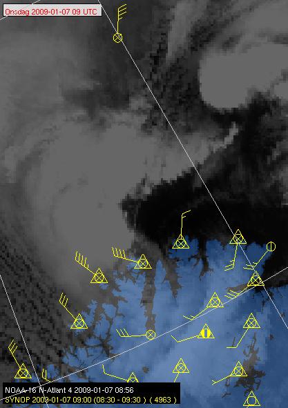
4 told by eye witnesses, but this is the first time that this is documented by observational data. Figure 3: Closeup of the AVHRR image at 09utc with wind observations from the ground stations. Figure 4: a) ASAR WSM from January 7, :01utc. b) ASAR surface wind speed using wind directions from ASCAT at 08:18 utc.
5 Summary Early detection of a polar low (November 18, 2008) with ASAR has been identified and discussed. As the SAR observes the wind at the surface, is gives a more direct information on surface wind patterns, perhaps also at an earlier time than what can be indirectly inferred from cloud top observing satellites. Fine scale features of the polar low can be seen with the high resolution SAR images. The sharp transition zone from the 'wind' side to the 'quiet' side of a polar low is documented in this study. Further work The scatterometer wind directions improve the resulting winds from SAR compared to using a numerical model, which was expected. The example in Figure 4b shows however that we need to test and possibly use the ASCAT coastal product in order to get SAR wind speed near the coast. Further work will also be to establish a comparison procedure to assess and quantify added fine scale wind information in SAR as compared to scatterometer footprints. References Reistad, M., Ø. Breivik, H. Haakenstad, O.J. Aarnes, B.R. Furevik and J.-R. Bidlot (2011) A highresolution hindcast of wind and waves for the North Sea, the Norwegian Sea and the Barents Sea, Journal of Geophysical Research, VOL. 116, C05019, doi: /2010jc006402, 2011
SAR images and Polar Lows
 SAR images and Polar Lows Gunnar Noer, Birgitte Furevik, Johannes Röhrs Observing polar lows in 2012: AVHRR Polar orbiting satellite imagery Primary source of info Observations at cloud tops Synoptic observations
THE POLARIMETRIC CHARACTERISTICS OF BOTTOM TOPOGRAPHY RELATED FEATURES ON SAR IMAGES
 THE POLARIMETRIC CHARACTERISTICS OF BOTTOM TOPOGRAPHY RELATED FEATURES ON SAR IMAGES Taerim Kim Professor, Ocean System Eng. Dept. Kunsan University Miryong Dong San 68, Kunsan, Jeonbuk, Korea, trkim@kunsan.ac.kr
Introduction EU-Norsewind
 Satellite winds in EU-Norsewind Charlotte Bay Hasager, Risø DTU, Denmark Alexis Mouche, CLS, France Merete Badger, Poul Astrup & Morten Nielsen, Risø DTU, Denmark Romain Husson, ESA Introduction EU-Norsewind
ADVANCES ON WIND ENERGY RESOURCE MAPPING FROM SAR
 ADVANCES ON WIND ENERGY RESOURCE MAPPING FROM SAR C.B. Hasager, M. Nielsen, M.B. Christiansen, R. Barthelmie, P. Astrup Risoe National Laboratory, Wind Energy Department, Frederiksborgvej 399, DK-4000
SPATIAL AND TEMPORAL VARIATIONS OF INTERNAL WAVES IN THE NORTHERN SOUTH CHINA SEA
 SPATIAL AND TEMPORAL VARIATIONS OF INTERNAL WAVES IN THE NORTHERN SOUTH CHINA SEA Weigen Huang (1), Johnny Johannessen (2,3), Werner Alpers (4) Jingsong Yang (1), Xilin Gan (1) (1) Second Institute of
STUDY OF LOCAL WINDS IN MOUNTAINOUS COASTAL AREAS BY MULTI- SENSOR SATELLITE DATA
 STUDY OF LOCAL WINDS IN MOUNTAINOUS COASTAL AREAS BY MULTI- SENSOR SATELLITE DATA Werner Alpers Institute of Oceanography, University of Hamburg, Bundesstrasse 53, D-20146 Hamburg, Germany E-mail: alpers@ifm.uni-hamburg.de
Assessing the quality of Synthetic Aperture Radar (SAR) wind retrieval in coastal zones using multiple Lidars
 wind retrieval in coastal zones using multiple Lidars") Assessing the quality of Synthetic Aperture Radar (SAR) wind retrieval in coastal zones using multiple Lidars Tobias Ahsbahs Merete Badger, Ioanna Karagali, Xiaoli Larsen What is the coastal zone? Coastal
Assessing the quality of Synthetic Aperture Radar (SAR) wind retrieval in coastal zones using multiple Lidars Tobias Ahsbahs Merete Badger, Ioanna Karagali, Xiaoli Larsen What is the coastal zone? Coastal
Development of SAR-Derived Ocean Surface Winds at NOAA/NESDIS
 Development of SAR-Derived Ocean Surface Winds at NOAA/NESDIS Pablo Clemente-Colón, William G. Pichel, NOAA/NESDIS Frank M. Monaldo, Donald R. Thompson The Johns Hopkins University Applied Physics Laboratory
North Atlantic wave height climate towards the end of the 21st century
 North Atlantic wave height climate towards the end of the 1st century Øyvind Breivik, Ole Johan Aarnes and Magnar Reistad RCP85-HISTORIC: annualmean 1 8 6 [%] -1 Ø Breivik et al (MET Norway) North Atlantic
USING SATELLITE SAR IN OFFSHORE WIND RESOURCE ASSESSMENT
 USING SATELLITE SAR IN OFFSHORE WIND RESOURCE ASSESSMENT B. R. Furevik (1), C. B. Hasager (2), M. Nielsen (2), T. Hamre (1), B. H. Jørgensen (2), O. Rathmann (2), and O. M. Johannessen (1,3) (1) Nansen
ON THE USE OF DOPPLER SHIFT FOR SAR WIND RETRIEVAL
 ON THE USE OF DOPPLER SHIFT FOR SAR WIND RETRIEVAL K-F. Dagestad 1, A. Mouche 2, F. Collard 2, M. W. Hansen 1 and J. Johannessen 1 (1) Nansen Environmental and Remote Censing Center, Thormohlens gt 47,
Impact of the loss of QuikSCAT on National Hurricane Center operations: Current mitigation efforts and future plans
 Impact of the loss of QuikSCAT on National Hurricane Center operations: Current mitigation efforts and future plans Rick Danielson1 and Mike Brennan NOAA/NWS/NCEP National Hurricane Center 1 UCAR visiting
Analyses of Scatterometer and SAR Data at the University of Hamburg
 Analyses of Scatterometer and SAR Data at the University of Hamburg Wind, Waves, Surface Films and Rain ГАДЕ, Мартин Хорстович (aka Martin Gade) Institut für Meereskunde, Universität Hamburg, Германия
EVALUATION OF ENVISAT ASAR WAVE MODE RETRIEVAL ALGORITHMS FOR SEA-STATE FORECASTING AND WAVE CLIMATE ASSESSMENT
 EVALUATION OF ENVISAT ASAR WAVE MODE RETRIEVAL ALGORITHMS FOR SEA-STATE FORECASTING AND WAVE CLIMATE ASSESSMENT F.J. Melger ARGOSS, P.O. Box 61, 8335 ZH Vollenhove, the Netherlands, Email: info@argoss.nl
Monitoring Conditions Offshore with Satellites
 Downloaded from orbit.dtu.dk on: Dec 15, 2017 Monitoring Conditions Offshore with Satellites Karagali, Ioanna; Hasager, Charlotte Bay; Badger, Merete; Bingöl, Ferhat; Ejsing Jørgensen, Hans Publication
Sea and Land Breezes METR 4433, Mesoscale Meteorology Spring 2006 (some of the material in this section came from ZMAG)
") Sea and Land Breezes METR 4433, Mesoscale Meteorology Spring 2006 (some of the material in this section came from ZMAG) 1 Definitions: The sea breeze is a local, thermally direct circulation arising from
Sea and Land Breezes METR 4433, Mesoscale Meteorology Spring 2006 (some of the material in this section came from ZMAG) 1 Definitions: The sea breeze is a local, thermally direct circulation arising from
Offshore wind mapping Mediterranean area using SAR
 Downloaded from orbit.dtu.dk on: Jan 12, 2019 Offshore wind mapping Mediterranean area using SAR Calaudi, Rosamaria; Arena, Felice; Badger, Merete; Sempreviva, Anna Maria Published in: Energy Procedia
Wind Atlas for the Gulf of Suez Satellite Imagery and Analyses
 Downloaded from orbit.dtu.dk on: Nov 09, 2017 Wind Atlas for the Gulf of Suez Satellite Imagery and Analyses Hasager, Charlotte Bay Publication date: 2003 Document Version Publisher's PDF, also known as
HIGH RESOLUTION WIND FIELDS OVER THE BLACK SEA DERIVED FROM ENVISAT ASAR DATA USING AN ADVANCED WIND RETRIEVAL ALGORITHM
 HIGH RESOLUTION WIND FIELDS OVER THE BLACK SEA DERIVED FROM ENVISAT ASAR DATA USING AN ADVANCED WIND RETRIEVAL ALGORITHM Werner Alpers (1), Alexis Mouche (2), Andrei Yu. Ivanov (3), Burghard Brümmer (4)
Offshore wind resource mapping in Europe from satellites
 Offshore wind resource mapping in Europe from satellites Charlotte Bay Hasager Seminar at University of Auckland, Dept. of Physics 1 April 2015 Content DTU Wind Energy Offshore wind turbines New European
Flow separation and lee-waves in the marine atmosphere
 Flow separation and lee-waves in the marine atmosphere Det norske Videnskabs-Akademi 16 Oct. 2009 Bjørn Gjevik Universitetet i Oslo epost: bjorng@math.uio.no Flow separation and lee-waves in the marine
Wind Direction Analysis over the Ocean using SAR Imagery
 Journal of Information & Computational Science 5: 1 (2008) 223-231 Available at http: www.joics.com Wind Direction Analysis over the Ocean using SAR Imagery Kaiguo Fan a,b,, Weigen Huang a, Mingxia He
THE EFFECT OF RAIN ON ASCAT OBSERVATIONS OF THE SEA SURFACE RADAR CROSS SECTION USING SIMULTANEOUS 3-D NEXRAD RAIN MEASUREMENTS
 THE EFFECT OF RAIN ON ASCAT OBSERVATIONS OF THE SEA SURFACE RADAR CROSS SECTION USING SIMULTANEOUS 3-D NERAD RAIN MEASUREMENTS David E. Weissman Hofstra University Hempstead, New York 11549 Mark A. Bourassa
Reprocessed QuikSCAT (V04) Wind Vectors with Ku-2011 Geophysical Model Function
 Wind Vectors with Ku-2011 Geophysical Model Function") Reprocessed QuikSCAT (V04) Wind Vectors with Ku-2011 Geophysical Model Function Lucrezia Ricciardulli and Frank Wentz Introduction In April 2011, we reprocessed the QuikSCAT ocean wind vectors using a
Reprocessed QuikSCAT (V04) Wind Vectors with Ku-2011 Geophysical Model Function Lucrezia Ricciardulli and Frank Wentz Introduction In April 2011, we reprocessed the QuikSCAT ocean wind vectors using a
THE QUALITY OF THE ASCAT 12.5 KM WIND PRODUCT
 THE QUALITY OF THE ASCAT 12.5 KM WIND PRODUCT Jur Vogelzang, Ad Stoffelen, Maria Belmonte, Anton Verhoef, and Jeroen Verspeek Royal Netherlands Meteorological Institute, Wilhelminalaan 10, 3732 GK, De
Synthetic aperture radar observations of sea surface signatures of atmospheric gravity waves over Southeast Asian coastal waters
 Synthetic aperture radar observations of sea surface signatures of atmospheric gravity waves over Southeast Asian coastal waters Werner Alpers Institute of Oceanography, University of Hamburg, Hamburg,
OCEAN vector winds from the SeaWinds instrument have
 IEEE GEOSCIENCE AND REMOTE SENSING LETTERS, VOL. 6, NO. 3, JULY 2009 413 Coastal Validation of Ultra-High Resolution Wind Vector Retrieval From QuikSCAT in the Gulf of Maine A. M. Plagge, Student Member,
SEA SURFACE TEMPERATURE RETRIEVAL USING TRMM MICROWAVE IMAGER SATELLITE DATA IN THE SOUTH CHINA SEA
 SEA SURFACE TEMPERATURE RETRIEVAL USING TRMM MICROWAVE IMAGER SATELLITE DATA IN THE SOUTH CHINA SEA Mohd Ibrahim Seeni Mohd and Mohd Nadzri Md. Reba Faculty of Geoinformation Science and Engineering Universiti
Review of Equivalent Neutral Winds and Stress
 Review of Equivalent Neutral Winds and Stress Mark A. Bourassa Center for Ocean-Atmospheric Prediction Studies, Geophysical Fluid Dynamics Institute & Department of Earth, Ocean and Atmospheric Science
Satellite information on ocean vector wind from Scatterometer data. Giovanna De Chiara
 Satellite information on ocean vector wind from Scatterometer data Giovanna De Chiara Why is Scatterometer important? The scatterometer measures the ocean surface winds (ocean wind vector). Ocean surface
IMPROVED OIL SLICK IDENTIFICATION USING CMOD5 MODEL FOR WIND SPEED EVALUATION ON SAR IMAGES
 IMPROVED OIL SLICK IDENTIFICATION USING CMOD5 MODEL FOR WIND SPEED EVALUATION ON SAR IMAGES H.KHENOUCHI & Y. SMARA University of Sciences and Technology Houari Boumediene (USTHB). Faculty of Electronics
REMOTE SENSING APPLICATION in WIND ENERGY
 REMOTE SENSING APPLICATION in WIND ENERGY Siraj Ahmed Professor & Head Department of Mechanical Engineering Maulana Azad National Iinstitute of Technology Bhopal, India sirajahmed@manit.ac.in Contents
Advancements in scatterometer wind processing
 Advancements in scatterometer wind processing Ad.Stoffelen@knmi.nl Marcos Portabella Anton Verhoef Jeroen Verspeek Jur Vogelzang scat@knmi.nl www.knmi.nl/scatterometer Scatterometer work The scatterometer
Comparison of data and model predictions of current, wave and radar cross-section modulation by seabed sand waves
 Comparison of data and model predictions of current, wave and radar cross-section modulation by seabed sand waves Cees de Valk, ARGOSS Summary SAR Imaging of seabed features Seabed Sand waves Objectives
Analyzing Surface Wind Fields Near Lower Cook Inlet And Kodiak Waters Using SAR
 J4.11 Analyzing Surface Wind Fields Near Lower Cook Inlet And Kodiak Waters Using SAR Eddie Zingone Weather Forecast Office, National Weather Service, Anchorage Alaska Gary L. Hufford Alaska Region Headquarters,
Characterization of Boundary-Layer Meteorology During DISCOVER-AQ
 Characterization of Boundary-Layer Meteorology During DISCOVER-AQ Daniel M. Alrick and Clinton P. MacDonald Sonoma Technology, Inc. Gary A. Morris St. Edward s University for Texas Air Quality Research
PRELIMINARY STUDY ON DEVELOPING AN L-BAND WIND RETRIEVAL MODEL FUNCTION USING ALOS/PALSAR
 PRELIMINARY STUDY ON DEVELOPING AN L-BAND WIND RETRIEVAL MODEL FUNCTION USING ALOS/PALSAR Osamu Isoguchi, Masanobu Shimada Earth Observation Research Center, Japan Aerospace Exploration Agency (JAXA) 2-1-1
High resolution wind fields over the Black Sea derived from Envisat ASAR data using an advanced wind retrieval algorithm
 High resolution wind fields over the Black Sea derived from Envisat ASAR data using an advanced wind retrieval algorithm Werner Alpers (1), Alexis Mouche (2), Andrei Yu. Ivanov (3), and Burghard Brümmer
DEVELOPMENT AND VALIDATION OF A SAR WIND EMULATOR
 The Nansen Environmental and Remote Sensing Center a non-profit research institute affiliated with the University of Bergen Thormøhlensgate 47, N-5006 Bergen Norway NERSC Technical Report no. 304 DEVELOPMENT
The Ice Contamination Ratio Method: Accurately Retrieving Ocean Winds Closer to the Sea Ice Edge While Eliminating Ice Winds
 The Ice Contamination Ratio Method: Accurately Retrieving Ocean Winds Closer to the Sea Ice Edge While Eliminating Ice Winds David Long Department of Electrical and Computer Engineering Brigham Young University
J4.2 AUTOMATED DETECTION OF GAP WIND AND OCEAN UPWELLING EVENTS IN CENTRAL AMERICAN GULF REGIONS
 J4.2 AUTOMATED DETECTION OF GAP WIND AND OCEAN UPWELLING EVENTS IN CENTRAL AMERICAN GULF REGIONS Xiang Li*, University of Alabama in Huntsville Huntsville, AL D. K. Smith Remote Sensing Systems Santa Rosa,
OBSERVATION OF HURRICANE WINDS USING SYNTHETIC APERTURE RADAR
 OBSERVATION OF HURRICANE WINDS USING SYNTHETIC APERTURE RADAR Jochen Horstmann 1, Wolfgang Koch 1,DonaldR.Thompson 2, and Hans C. Graber 3 1 Institute for Coastal Research, GKSS Research Center, Geesthacht,
ASSESSMENT OF SEA BREEZE CHARACTERISTICS FROM SODAR ECHOGRAMS
 ASSESSMENT OF SEA BREEZE CHARACTERISTICS FROM SODAR ECHOGRAMS SUNEETHA RANI. JUPUDI Prof. M. PURNACHANDRA RAO Department of Physics, Andhra University, Visakhapatnam, India. ABSTRACT The SODAR echograms
An Atlas of Oceanic Internal Solitary Waves (February 2004) by Global Ocean Associates Prepared for Office of Naval Research Code 322 PO
 by Global Ocean Associates Prepared for Office of Naval Research Code 322 PO") Overview The is located in the North Atlantic Ocean between southern Ireland and southwest England (Figure 1). The Sea s western edge covers a continental shelf region characterized by rough and irregular
Overview The is located in the North Atlantic Ocean between southern Ireland and southwest England (Figure 1). The Sea s western edge covers a continental shelf region characterized by rough and irregular
Using several data sources for offshore wind resource assessment
 Author manuscript, published in ", Copenhagen : Denmark (2005)" Ben Ticha M. B., Ranchin T., Wald L., Using several data sources for offshore wind resource assessment, 2005, Using several data sources
OBSERVATIONS OF ATMOSPHERIC GRAVITY WAVES OVER THE CHINESE SEAS BY SPACEBORNE SYNTHETIC APERTURE RADAR
 OBSERVATIONS OF ATMOSPHERIC GRAVITY WAVES OVER THE CHINESE SEAS BY SPACEBORNE SYNTHETIC APERTURE RADAR W. Alpers (1), W. Huang (2), G. Xilin (2) (1) Center for Marine and Climate Research, Institute of
SENSOR SYNERGY OF ACTIVE AND PASSIVE MICROWAVE INSTRUMENTS FOR OBSERVATIONS OF MARINE SURFACE WINDS
 SENSOR SYNERGY OF ACTIVE AND PASSIVE MICROWAVE INSTRUMENTS FOR OBSERVATIONS OF MARINE SURFACE WINDS N. Ebuchi Institute of Low Temperature Science, Hokkaido University, N19-W8, Kita-ku, Sapporo 060-0819,
IMPROVED BAYESIAN WIND VECTOR RETRIEVAL SCHEME USING ENVISAT ASAR DATA: PRINCIPLES AND VALIDATION RESULTS
 IMPROVED BAYESIAN WIND VECTOR RETRIEVAL SCHEME USING ENVISAT ASAR DATA: PRINCIPLES AND VALIDATION RESULTS Vincent Kerbaol (1), and the SAR Ocean Wind, Waves and Currents Team (1) BOOST Technologies, 115
Wind Stress Working Group 2015 IOVWST Meeting Portland, OR
 Wind Stress Working Group 2015 IOVWST Meeting Portland, OR Summary of Research Topics, Objectives and Questions James B. Edson University of Connecticut SPURS Mooring, Farrar, WHOI Background Motivation
RIVET Satellite Remote Sensing and Small Scale Wave Process Analysis
 DISTRIBUTION STATEMENT A. Approved for public release; distribution is unlimited. RIVET Satellite Remote Sensing and Small Scale Wave Process Analysis Hans C. Graber RSMAS Department of Ocean Sciences
Swell (wind) fields obtained from Satellite Observation CLS Christian Ortega - Mission blue Journées Annuelles des Hydrocarbures 2013
 fields obtained from Satellite Observation CLS Christian Ortega - Mission blue Journées Annuelles des Hydrocarbures 2013") Swell (wind) fields obtained from Satellite Observation CLS Christian Ortega - cortega@cls.fr Mission blue Journées Annuelles des Hydrocarbures 2013 Purpose Develop new methodologies to obtain swell (wind)
Swell (wind) fields obtained from Satellite Observation CLS Christian Ortega - cortega@cls.fr Mission blue Journées Annuelles des Hydrocarbures 2013 Purpose Develop new methodologies to obtain swell (wind)
Using Satellite Spectral Wave Data for Wave Energy Resource Characterization
 Using Satellite Spectral Wave Data for Wave Energy Resource Characterization M. T. ontes 1,2, M. Bruck 3, S. Lehener 3, A. Kabuth 1,4 1 LNEG Estrada do aço do Lumiar 1649-038 Lisboa, ortugal teresa.pontes@lneg.pt
ERS-1/2 Scatterometer new products: mission reprocessing and data quality improvement
 ERS-1/2 Scatterometer new products: mission reprocessing and data quality improvement Giovanna De Chiara (1), Raffaele Crapolicchio (1), Pascal Lecomte (2) (1) Serco SpA Via Sciadonna 22-24 Frascati (Roma),
Cross-Calibrating OSCAT Land Sigma-0 to Extend the QuikSCAT Land Sigma-0 Climate Record
 Cross-Calibrating OSCAT Land Sigma-0 to Extend the QuikSCAT Land Sigma-0 Climate Record David G. Long Department of Electrical and Computer Engineering Brigham Young University May 2013 0 Scatterometer
ERS WAVE MISSION REPROCESSING- QC SUPPORT ENVISAT MISSION EXTENSION SUPPORT
 REPORT 8/2011 ISBN 978-82-7492-248-8 ISSN 1890-5218 ERS WAVE MISSION REPROCESSING- QC SUPPORT ENVISAT MISSION EXTENSION SUPPORT - Annual Report 2010 Author (s): Harald Johnsen (Norut), Fabrice Collard
High Resolution Sea Surface Roughness and Wind Speed with Space Lidar (CALIPSO)
") High Resolution Sea Surface Roughness and Wind Speed with Space Lidar (CALIPSO) Yongxiang Hu NASA Langley Research Center Carl Weimer Ball Aerospace Corp. 1 CALIPSO Mission Overview CALIPSO seeks to improve
High Resolution Sea Surface Roughness and Wind Speed with Space Lidar (CALIPSO) Yongxiang Hu NASA Langley Research Center Carl Weimer Ball Aerospace Corp. 1 CALIPSO Mission Overview CALIPSO seeks to improve
CHANGE OF THE BRIGHTNESS TEMPERATURE IN THE MICROWAVE REGION DUE TO THE RELATIVE WIND DIRECTION
 JP4.12 CHANGE OF THE BRIGHTNESS TEMPERATURE IN THE MICROWAVE REGION DUE TO THE RELATIVE WIND DIRECTION Masanori Konda* Department of Geophysics, Graduate School of Science, Kyoto University, Japan Akira
RapidScat wind validation report
 Ocean and Sea Ice SAF Technical Note SAF/OSI/CDOP2/KNMI/TEC/RP/228 25 and 50 km wind products (OSI-109) Anton Verhoef, Jur Vogelzang and Ad Stoffelen KNMI Version 1.1 March 2015 DOCUMENTATION CHANGE RECORD
WEATHER SYSTEMS OF MIDDLE LATITUDES
 CHAPTER 10 WEATHER SYSTEMS OF MIDDLE LATITUDES MULTIPLE CHOICE QUESTIONS 1. In equal volumes, which one of the following air masses exerts the highest surface air pressure? a. cp *b. A c. mp d. ct e. mt
HIGH RESOLUTION WIND AND WAVE MEASUREMENTS FROM TerraSAR-X IN COMPARISON TO MARINE FORECAST
 SAR Maritime Applications German Aerospace Center (DLR) Remote Sensing Technology Institute Maritime Security Lab HIGH RESOLUTION WIND AND WAVE MEASUREMENTS FROM TerraSAR-X IN COMPARISON TO MARINE FORECAST
Satellite Observations of Equatorial Planetary Boundary Layer Wind Shear
 Satellite Observations of Equatorial Planetary Boundary Layer Wind Shear David Halpern and Michael Garay NASA / California Institute of Technology Jet Propulsion Laboratory Pasadena, California, USA Thanks
ATMS 310 Tropical Dynamics
 ATMS 310 Tropical Dynamics Introduction Throughout the semester we have focused on mid-latitude dynamics. This is not to say that the dynamics of other parts of the world, such as the tropics, are any
Xiaoli Guo Larsén,* Søren Larsen and Andrea N. Hahmann Risø National Laboratory for Sustainable Energy, Roskilde, Denmark
 Quarterly Journal of the Royal Meteorological Society Q. J. R. Meteorol. Soc. 138: 274 279, January 2012 A Notes and Correspondence Origin of the waves in A case-study of mesoscale spectra of wind and
The relevance of ocean surface current in the ECMWF analysis and forecast system. Hans Hersbach Jean-Raymond Bidlot
 The relevance of ocean surface current in the ECMWF analysis and forecast system Hans Hersbach Jean-Raymond Bidlot European Centre for Medium Range Weather Forecasts, Reading, U.K. hans.hersbach@ecmwf.int
Exercise: Satellite Imagery Analysis. 29 June 2016 Japan Meteorological Agency
 Exercise: Satellite Imagery Analysis 29 June 2016 Japan Meteorological Agency Contents 1. Fog/Stratiform Cloud 2. Cb (Cumulonimbus)/Cg (Cumulus congestus) 3. Upper-level Flow Jet stream, upper trough,
Application of a new algorithm using Doppler information to retrieve complex wind fields over the Black Sea from ENVISAT SAR images
 1 International Journal Of Remote Sensing 2015, Volume 36 Issue 3 Pages 863-881 http://dx.doi.org/10.1080/01431161.2014.999169 http://archimer.ifremer.fr/doc/00253/36390/ 2015 Taylor & Francis Achimer
Abrupt marine boundary layer changes revealed by airborne in situ and lidar measurements
 Abrupt marine boundary layer changes revealed by airborne in situ and lidar measurements David A. Rahn 1, Thomas R. Parish 2, and David Leon 2 1 Univeristy of Kansas 2 Univeristy of Wyoming Precision Atmospheric
P2.25 SUMMER-TIME THERMAL WINDS OVER ICELAND: IMPACT OF TOPOGRAPHY. Bergen
 P2.25 SUMMER-TIME THERMAL WINDS OVER ICELAND: IMPACT OF TOPOGRAPHY Haraldur Ólafsson 1 and Hálfdán Ágústsson 2 1 University of Iceland, Bergen School of Meteorology, Geophysical Institute, University of
Bias assessment of MODIS/MISR winds
 Bias assessment of MODIS/MISR winds Feng Lu, Yixuan Shou, Xiaohu Zhang, Jianmin Xu Office of System Development, National Satellite Meteorological Center/CMA 13th International Winds Workshop (IWW13),
Atmospheric Waves James Cayer, Wesley Rondinelli, Kayla Schuster. Abstract
 Atmospheric Waves James Cayer, Wesley Rondinelli, Kayla Schuster Abstract It is important for meteorologists to have an understanding of the synoptic scale waves that propagate thorough the atmosphere
Climatology of the 10-m wind along the west coast of South American from 30 years of high-resolution reanalysis
 Climatology of the 10-m wind along the west coast of South American from 30 years of high-resolution reanalysis David A. Rahn and René D. Garreaud Departamento de Geofísica, Facultad de Ciencias Físicas
Geophysical Model Functions for the Retrieval of Ocean Surface Winds
 Geophysical Model Functions for the Retrieval of Ocean Surface Winds Donald R. Thompson and Frank M. Monaldo Johns Hopkins University Applied Physics Laboratory 11100 Johns Hopkins Road, Laurel, MD 20708
OPERATIONAL AMV PRODUCTS DERIVED WITH METEOSAT-6 RAPID SCAN DATA. Arthur de Smet. EUMETSAT, Am Kavalleriesand 31, D Darmstadt, Germany ABSTRACT
 OPERATIONAL AMV PRODUCTS DERIVED WITH METEOSAT-6 RAPID SCAN DATA Arthur de Smet EUMETSAT, Am Kavalleriesand 31, D-64295 Darmstadt, Germany ABSTRACT EUMETSAT started its Rapid Scanning Service on September
DANISH METEOROLOGICAL INSTITUTE
 DANISH METEOROLOGICAL INSTITUTE TECHNICAL REPORT No. 01-04 Detailed Wind Speed Information From RADARSAT ScanSAR Wide February 2001 Rasmus Tage Tonboe ISSN 0906-897X Copenhagen 2001 0 Preface This report
Original DOI: /2008MWR2563.1
 Original Alpers, W.; Ivanov, A.; Horstmann, J.: Observations of Bora Events over the Adriatic Sea and Black Sea by Spaceborne Synthetic Aperture Radar In: Monthly Weather Review (2009) AMS DOI: 10.1175/2008MWR2563.1
Deborah K. Smith, Frank J. Wentz, and Carl A. Mears Remote Sensing Systems
 JP 4.9 RESULTS OF QUIKSCAT HIGH WIND DATA VALIDATION Deborah K. Smith, Frank J. Wentz, and Carl A. Mears Remote Sensing Systems ABSTRACT Traditional validation of satellite-derived winds includes comparison
WaMoS II Wave Monitoring System
 WaMoS II Wave Monitoring System - An application of WaMoS II at Duck - Katrin Hessner, K. Reichert, J. Dannenberg OceanWaveS GmbH, Germany Kent Hathaway, Don Resio Engineering Research Development Center
Singularity analysis: A poweful technique for scatterometer wind data processing
 Singularity analysis: A poweful technique for scatterometer wind data processing M. Portabella (ICM-CSIC) W. Lin (ICM-CSIC) A. Stoffelen (KNMI) A. Turiel (ICM-CSIC) G. King (ICM-CSIC) A. Verhoef (KNMI)
G. Meadows, H. Purcell and L. Meadows University of Michigan
 www.coj.net/departments/fire+and+rescue/emergency+preparedness/rip+current.htm G. Meadows, H. Purcell and L. Meadows Over 80% of all surf related rescues are attributable to Rip Currents According to the
07/23/02 FC: All aircraft suppressed day hoping for late take-off
 07/23/02 FC: Report: Summary: Aircraft: All aircraft suppressed day hoping for late take-off The forecast called for redeveloping maritime convection NE of Florida, with cloud tops getting to 12 to 14
RZGM Wind Atlas of Aegean Sea with SAR data
 RZGM2013-14 - Wind Atlas of Aegean Sea with SAR data Ferhat Bingöl 1, Charlotte B. Hassager 2, Merete Badger 3 and Jake Badger 4 Denmark Technical University, Wind Energy, Frederiksborgvej 399 4000 Roskilde,
Evidence of Mesoscale Lows off the West Coast of New Zealand
 369 Evidence of Mesoscale Lows off the West Coast of New Zealand ANDREW K. LAING AND STEVE J. REID National Institute of Water and Atmospheric Research, Wellington, New Zealand (Manuscript received 29
GLOBAL VALIDATION AND ASSIMILATION OF ENVISAT ASAR WAVE MODE SPECTRA
 GLOBAL VALIDATION AND ASSIMILATION OF ENVISAT ASAR WAVE MODE SPECTRA Saleh Abdalla, Jean-Raymond Bidlot and Peter Janssen European Centre for Medium-Range Weather Forecasts, Shinfield Park, RG 9AX, Reading,
Coastal Scatterometer Winds Working Group
 Coastal Scatterometer Winds Working Group IOVWST Meeting 2015 Portland, Oregon, USA Melanie Fewings Julia Figa Saldaña Bryan Stiles Steve Morey Dmitry Dukhovskoy Larry O Neill if you want to be added to
THE ATMOSPHERE. WEATHER and CLIMATE. The Atmosphere 10/12/2018 R E M I N D E R S. PART II: People and their. weather. climate?
 R E M I N D E R S Two required essays are due by Oct. 30, 2018. (A third may be used for extra credit in place of a Think Geographically essay.) ESSAY TOPICS (choose any two): Contributions of a noted
NONLINEAR INTERNAL WAVES IN THE SOUTH CHINA SEA
 25 th ACRS 2004 Chiang Mai, Thailand xxx NONLINEAR INTERNAL WAVES IN THE SOUTH CHINA SEA Ming-Kuang Hsu Professor, Kuang Wu Institute of Technology, Taipei, Taiwan, R.O.C. Hsumk@kwit.edu.tw Antony K. Liu
SMAP Radiometer-Only Tropical Cyclone Size and Strength
 SMAP Radiometer-Only Tropical Cyclone Size and Strength Alexander Fore, Simon Yueh, Wenqing Tang, Bryan SCles, Akiko Hayashi Jet Propulsion Laboratory, California InsCtute of Technology 218 California
HIGH-RESOLUTION RADAR WAVE AND CURRENT MEASUREMENTS IN HIGHLY INHOMOGENEOUS COASTAL AREAS
 HIGH-RESOLUTIO RADAR WAVE AD CURRET MEASUREMETS I HIGHLY IHOMOGEEOUS COASTAL AREAS Katrin Hessner, Konstanze Reichert, and Jose Carlos ieto Borge OceanWaveS GmbH, Lueneburg, Germany, hessner@oceanwaves.de
Prediction of Nearshore Waves and Currents: Model Sensitivity, Confidence and Assimilation
 Prediction of Nearshore Waves and Currents: Model Sensitivity, Confidence and Assimilation H. Tuba Özkan-Haller College of Oceanic and Atmospheric Sciences Oregon State University, 104 Ocean Admin Bldg
Global Wind Speed Retrieval From SAR
 IEEE TRANSACTIONS ON GEOSCIENCE AND REMOTE SENSING, VOL. 41, NO. 10, OCTOBER 2003 2277 Global Wind Speed Retrieval From SAR Jochen Horstmann, Helmut Schiller, Johannes Schulz-Stellenfleth, and Susanne
Statistics of wind and wind power over the Mediterranean Sea
 Conférence Méditerranéenne Côtière et Maritime EDITION 2, TANGER, MAROC (2011) Coastal and Maritime Mediterranean Conference Disponible en ligne http://www.paralia.fr Available online Statistics of wind
ASAP Satellite-based tropopause fold and mountain wave detection and validation
 ASAP Satellite-based tropopause fold and mountain wave detection and validation Tony Wimmers, Kristopher M. Bedka, Wayne Feltz, Nathan Uhlenbrock Cooperative Institute for Meteorological Satellite Studies
Observations of Oceanic Internal Waves in Bay of Bengal using Synthetic Aperture Radar
 Observations of Oceanic Internal Waves in Bay of Bengal using Synthetic Aperture Radar K.V.S.R. Prasad and M. Rajasekhar Department of Meteorology & Oceanography, Andhra University,Visakhapatnam-530 033,
Validation of 12.5 km and Super-High Resolution (2-5 km)
") Coastal and Orographic Wind Analyses from High Resolution QuikSCAT and SeaWinds Measurements M.H. Freilich, COAS/OSU D.B. Chelton, COAS/OSU D.G. Long, BYU Clive Dorman, SIO Barry Vanhoff, COAS/OSU OVWST
Coastal and Orographic Wind Analyses from High Resolution QuikSCAT and SeaWinds Measurements M.H. Freilich, COAS/OSU D.B. Chelton, COAS/OSU D.G. Long, BYU Clive Dorman, SIO Barry Vanhoff, COAS/OSU OVWST
ATOMOSPERIC PRESSURE, WIND & CIRCULATION
 ATOMOSPERIC PRESSURE, WIND & CIRCULATION A. INTRODUCTION Important because: pressure patterns drive wind patterns which in turn drive oceanic circulation patterns o atmospheric & oceanic circulation: major
Beach Wizard: Development of an Operational Nowcast, Short-Term Forecast System for Nearshore Hydrodynamics and Bathymetric Evolution
 Beach Wizard: Development of an Operational Nowcast, Short-Term Forecast System for Nearshore Hydrodynamics and Bathymetric Evolution Ad Reniers Civil Engineering and Geosciences, Delft University of Technology
Idealized WRF model sensitivity simulations of sea breeze types and their effects on offshore windfields: Supplementary material
 Idealized WRF model sensitivity simulations of sea breeze types and their effects on offshore windfields: Supplementary material Authors: C. J. Steele, S. R. Dorling, R. von Glasow and J. Bacon Synoptic
QuikScat/Seawinds Sigma-0 Radiometric and Location Accuracy Requirements for Land/Ice Applications
 Brigham Young University Department of Electrical and Computer Engineering 459 Clyde Building Provo, Utah 84602 QuikScat/Seawinds Sigma-0 Radiometric and Location Accuracy Requirements for Land/Ice Applications
Fishery. ल ȁ ݽ ༭ ȜΫΑΓϋΗȜ. Katsuya Saitoh Japan Fisheries Information Service Center
 ݽ 8 Fishery ल ȁ ݽ ༭ ȜΫΑΓϋΗȜ Katsuya Saitoh Japan Fisheries Information Service Center 8.1 Present Status of Japanese Fisheries Landed Quantity [ ton ] 5,000,000 4,500,000 4,000,000 3,500,000 3,000,000
Summary of Lecture 10, 04 March 2008 Introduce the Hadley circulation and examine global weather patterns. Discuss jet stream dynamics jet streams
 Summary of Lecture 10, 04 March 2008 Introduce the Hadley circulation and examine global weather patterns. Discuss jet stream dynamics jet streams arise because the Coriolis force prevents Hadley-type