Swell (wind) fields obtained from Satellite Observation CLS Christian Ortega - Mission blue Journées Annuelles des Hydrocarbures 2013
|
|
|
- Camilla Hood
- 6 years ago
- Views:
Transcription

1 Swell (wind) fields obtained from Satellite Observation CLS Christian Ortega - cortega@cls.fr Mission blue Journées Annuelles des Hydrocarbures 2013
2 Purpose Develop new methodologies to obtain swell (wind) statistics and forecasts from radar SAR satellites «deep» (>200m) to coastal waters Olivier Clasperis
3 Content Context & Objectives Swell from SAR images: principle & Fireworks Coastal swell field emulation: pilot in Iroise sea Improving «deep» sea swell product Conclusion & Perspectives


4 Collected Localisation Satellite (CLS) overview Created: 21 April 1986 Core activities: Commercial operation of satellite systems for positioning, data collection, ocean observation and surveillance Developing added-value applications and services based on satellite remote-sensing data; Sectors of activity: environmental surveillance, sustainable management of marine resources, maritime security, oil and gas; Shareholders: 2012 income: 79 M Page 4
5 A CITEPH project Reference: CITEPH «Emulateur d état de mer (vagues, vents et courants) à haute résolution en zone côtière à partir d image satellite» Leader: CLS Partner: IFREMER Sponsors: Total, Technip CITEPH budget : 300k 13-oct-2013 Journées Annuelles des Hydrocarbures octobre 2013
6 Why use satellite data? (versus existing methods) Long swell can severly impact operations at sea, but Some swell are not well represented by wave models Their propagation is poorly known in coastal areas Radar SAR satellite observations provide: High resolution (few km) swell (and wind) data Independant from the models In deep ocean and coastal area Satellite approach is likely to improve information on swell, safety & minimize costs Oct-2013 Référence CITEPH: CITEPH
7 O&G & RME target applications Design (O&G RME) Refined swell characteristics for structure design (statistical studies) In particular storms & cross swells Weather sensitive Marine operation (O&G RME) Sea state statistics to prepare operations at sea Swell forecast in support of the marine operation Renewable Marine Energy (RME) Identify best sites and assess energy potential 03-avr-2013 Référence CITEPH: CITEPH
8 Plan Context & Objectives Swell from SAR images: principle & Fireworks Coastal swell field emulation: pilot in Iroise sea Improving «deep» sea swell product Conclusion & Perspectives


9 Extracting swell (& wind) from sea roughness Short centi/decimetric waves: Roughness source, distributed along the long wave profiles. extraction of wind (V/D) Long waves (swell Wavelenght>150 m) : Modify the distribution of the short waves and the local incidence angle. Periodical signal detected on the SAR image can be related to the swell. extraction of swell spectra: H s, λ p, T p, D p Medium waves: Produce an average «noise» on the SAR image wind sea (waves) cannot be observed
10 Radar SAR satellite & waves Satellite SAR is the only instrument able to provide global swell spectra measurements SAR provides swell directional spectra (H s,t p,λ p,d p ) via 2 modes: - Wave mode (automatic aquisitions) - default mode in medium to deep waters - images of 10x10 km collected every 100 km - Image mode - acquisition on request OR automatic for «super-sites» (Iroise sea, Aghulas currents, Gulf Stream, Northern Europe )

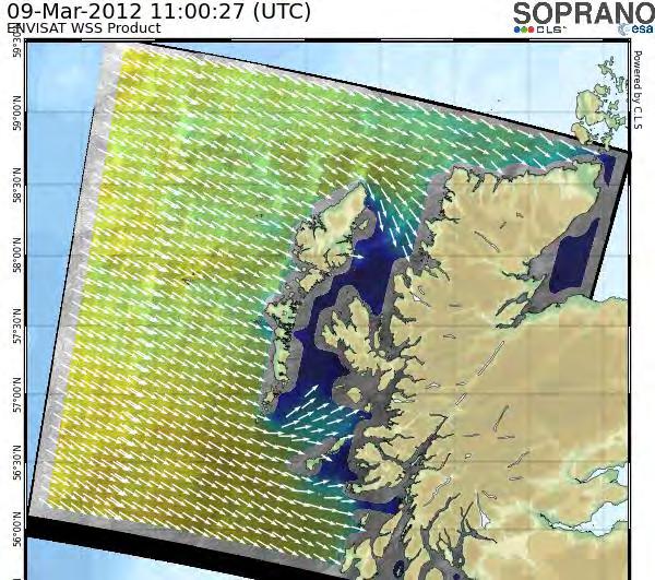
11 SAR image & wave acquisition modes (ENVISAT) Application «deep» sea: swell tracking Application coastal wave emulation
12 Radar SAR space missions SAR satellite mission Period Band Owner ERS-2 03/ /2011 C ESA ASAR (ENVISAT) 03/ /2012 C ESA Sentinel 1 (2) C ESA CFOSAT C CNSA-SOA-CNES
13 CLS involvement in Waves and radar SAR data Responsible for the calibration/validation of SAR wave mode data for ENVISAT mission ( ) + production for Sentinel-1 satellites (wave, wind ) The (CLS) Vigisat acquisition station, in Brest, used since 2011 (special negociated agreement with ESA), for the reception and processing of ESA SAR satellites SAR data received in near real time at CLS Dedicated processing systems developed for Vigisat Consequent data catalog available IFREMER is responsible for the mission wave mode archiving re-processing (ERS- 1/2 and ENVISAT missions).


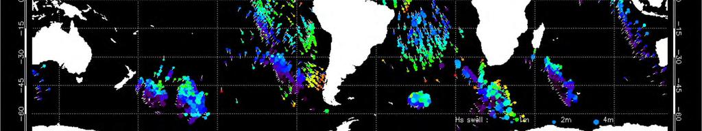
14 Swell from SAR wave mode: Fireworks

15 Swell from SAR wave mode: how it works Wind field rebuilding Detection of storm sources and refocalisation of observations made along satellite track. Synthesis of propagated swell field along great circles in all directions and until reaching coastline.

 swell systems crossing at a significant")
16 «Deep» ocean swell products cross swell maps Statistical maps processed over a year Risk area for navigation Cross-swells: 2 energetic (Hss>1m) swell systems crossing at a significant angle (>45 )


17 «Deep» ocean swell products virtual wave buoy Extract swell field on a given spot Time evolution of H s, λ p, T p, D p for each swell system Total swell wave height for all systems Provide wave spectra & statistics Provide 48 to 72 hours forecasts Interest Early warning for energetic waves Swell climatology for RME resources, Offshore structure design
18 Plan Context & Objectives Swell from SAR images: principle & Fireworks Coastal swell field emulation: pilot in Iroise sea Improving «deep» sea swell product Conclusion & Perspectives
19 Methodology - Principle For a given swell (direction, peak period, Hs), the propagation of swell fields is mainly determined by: bathymetry ocean currents Phenomena can be reproduced There is a relation between the measure of a swell field in a given spot and its high resolution spatial distribution
 and high resolution swell fields 3.")
20 Methodology Coastal swell emulation, 3 steps 1. Build databases: low resolution (BR, in-situ observations or model data) and high resolution (HR 5 km, SAR data) 2. Learning: associate low (in-situ) and high resolution swell fields 3. Produce (emulate) HR swell fields (Hs, Dir, wavelength) using low resolution data (in-situ waverider or wave model) & weighted averages Y HR( p ) = F Y W p ( ) { X BR, k, X HR, k} BR


21 SAR HR database over Europe & swell map example (1) WSM image catalog
 In service since")
22 Pilote site & in-situ data Iroise sea Directionnal wave buoy : Les Pierres Noires Location : ,42'N ,1'W Depth : 60 m One directionnal spectra every 30 min (1488 for 31 days) In service since


23 Impossible d afficher l image. Swell spectral analysis & partition (1) Extracting swell systems from SAR image database (181 images)


24 A single swell system A single swell system

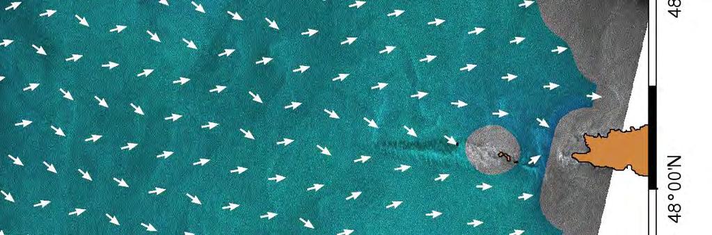
25 Two swell systems cross seas Two swell systems cross seas
26 Linking together the same (SAR) swell systems (1) Extraction of different swell systems and their reference wavenumber and direction For each grid point from fixed geographic grid Retro propagation of wavevector to evaluate the incident swell wavenumber and direction This retro propagation is based on local wavenumber and direction from SAR grid partitions 1
27 Classifying and gridding swell systems (1) Characterisation of the swell situation from spectral partitions: two swell systems here Fixed geographic grid SAR image grid Isle Swell field partitions restituted on a SAR grid. Vectors indicate direction and wavelength. Two swell systems are indicated by different colors (red & blue).
28 Linking the (SAR) swell systems to the swell at the buoy (2) Learning step (2) Waverider buoy reference wavevector (SAR) swell reference vector Isle Associating the (SAR) swell system on a fixed geographic grid and associated reference incident wavevector at the waverider buoy
29 Emulation process (3) Once swell spectra partitionning and association between wave buoy data and HR (SAR) swell systems (done in steps 1 & 2): Search in the learning database the sets of SAR swell systems with a wavenumber and direction at the buoy location that are close to swell wavenumber and direction measured by the buoy. For each swell system measured by the buoy, an (HR) swell field is produced at each grid point when more than one SAR observation matches the givenwave buoy partition. The wave field is produced by averaging all the associated SAR swell fields contained in the database & propagated over the coastal area (time of occurrence)
30 Swell propagation : calculating time of occurrence (3) Propagating the swell emulated at the reference point to the coastal area Low resolution incident wavevector at the buoy Estimation of the propagation time between HR observations ( ) to LR information ( ). D =Cg.t Cg is the the group velocity of the reference wavevector. Isle
 & density of SAR images")
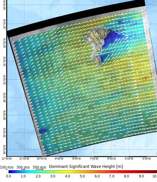
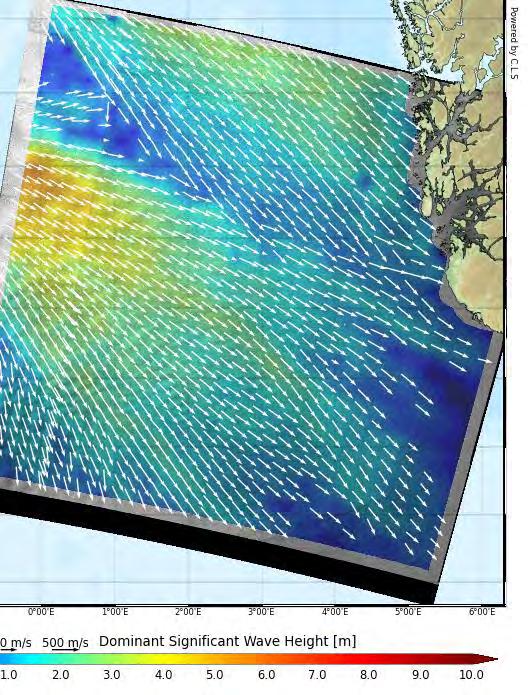
31 Results Bathy. (left) & density of SAR images (right) All swell systems
 & density of SAR images (right) Example of a")
32 Results Bathy. (left) & density of SAR images (right) Example of a frequent swell : W direction, 250 m wavelength
 & dominant wavelength (right) Example of a")
33 Results Bathy. (left) & dominant wavelength (right) Example of a frequent swell houle: direction W, 250 m wavelength
 & significant swell (right) Example of a frequent")
34 Results Bathy. (left) & significant swell (right) Example of a frequent swell houle: direction W, 250 m wavelength

35 Results Bathymetry (left) & wave direction (right) Example of a frequent swell houle: direction W, 250 m wavelength
36 Hs comparison at les Pierres Noires buoy RMS diff : 40cm RMS diff : 51cm Physical tidal current taken into account Offshore (W005,6 N48,4) Statistical Tide level within 2m RMS diff : 45cm Coastal (Les Pierres Noires)
37 Results: emulability tradeoff Direction within 20, wavelength within 25m, all tides : 84.6% emulability Direction within 20, wavelength within 25m, tide level within 2m : 62.4% emulability RMS difference between emulated and buoy Hs from 0.49m to 0.45m when tide level within 2m RMS difference of 0.40m between WW3 and buoy Limitation: short wavelength ( m), dataset size Tradeoff between accuracy of emulated field and percentage of conditions than can be emulated.
38 Plan Context & Objectives Swell from SAR images: principle & Fireworks Coastal swell field emulation: pilot in Iroise sea Improving «deep» sea swell product Conclusion & Perspectives

39 Swell at deeper waters (>200m) - Fireworks Satellite Observations L2 Swell field rebuilding Publications: R. Husson, F. Ardhuin, F. Collard, B. Chapron, et A. Balanche, «Revealing forerunners on Envisat s wave mode ASAR using the Global Seismic Network», Geophys. Res. Lett., vol. 39, no. 15, p. L15609, août R. Husson, Thesis manuscript, Development and validation of a global observation-based swell model using Synthetic Aperture Radar operating in wave mode, 2012 Swell fields Propagated observations Synthetic fields Filtering and gridding Virtual buoys Fireworks


40 Enhancing fireworks using «coastal» SAR image dataset Without using data from image mode Using data from image mode Graphical data, global view
 Global view, available for each swell")
41 Swell «deep» waters Fireworks - Wavelenght Synthetic fields Wavelengths Propagated data Filtered and gridded data Graphical or scientific output formats(netcdf) Global view, available for each swell field
 Global view, available for each")
42 Swell at «deep» waters Fireworks (Hs) Synthetic fields - Hss Propagated data Filtered and gridded data Graphical or scientific output formats(netcdf) Global view, available for each swell field


43 Swell at «deeper» depth Fireworks wave & wind
44 Results «Deep» ocean Standard errors SAR/in-situ/model data inter-comparison Observations - Level 2 Champs Synthetic fields - Level3
45 Results «Deep» ocean Standard errors SAR/in-situ/model data inter-comparison Significant height[cm] Periode [s] Direction [deg] SAR data - level 3 < 30* Wavewatch III model < 30** *Performance dependent on SAR sampling quality criteria ** Performance dependent on storm localization localisation (Energy dissipation problem in models)
46 Plan Context & Objectives Swell from SAR images: principle & Fireworks Coastal swell field emulation: pilot in Iroise sea Improving «deep» sea swell product Conclusion & Perspectives
47 Conclusion & Perspectives Coastal swell Coastal Swell: from R&D to operational Concept is validated Work with operators (Total, Shell, Statoil ) to implement emulators in severe areas such as NW Ireland, Shetlands, Offshore Norway. Possibly through a JIP. Historical / Statistical studies then operational forecasts «Deep» sea Swell: operational Clear advantage on model in storm areas Historical / Statistical studies now Swell forecasts available after Sentinel-1 satellite launch (2014)


48 Analog dev. for wind: Image mode product/statistics Exemple de rose des vents pour Horns Rev calculée à partir du catalogue d images ASAR disponibles à CLS: Comparaison avec 6 ans de sortie ECMWF SAR 1x1 km ECMWF (0.5 ) 10-minute meteorological observations

49 THANK YOU FOR YOUR ATTENTION
Dynamic validation of Globwave SAR wave spectra data using an observation-based swell model. R. Husson and F. Collard
 Dynamic validation of Globwave SAR wave spectra data using an observation-based swell model. R. Husson and F. Collard Context 1978 1979 1980 1981 1982 1983 1984 1985 1986 1987 1988 1989 1990 1991 1992
EVALUATION OF ENVISAT ASAR WAVE MODE RETRIEVAL ALGORITHMS FOR SEA-STATE FORECASTING AND WAVE CLIMATE ASSESSMENT
 EVALUATION OF ENVISAT ASAR WAVE MODE RETRIEVAL ALGORITHMS FOR SEA-STATE FORECASTING AND WAVE CLIMATE ASSESSMENT F.J. Melger ARGOSS, P.O. Box 61, 8335 ZH Vollenhove, the Netherlands, Email: info@argoss.nl
Development of SAR-Derived Ocean Surface Winds at NOAA/NESDIS
 Development of SAR-Derived Ocean Surface Winds at NOAA/NESDIS Pablo Clemente-Colón, William G. Pichel, NOAA/NESDIS Frank M. Monaldo, Donald R. Thompson The Johns Hopkins University Applied Physics Laboratory
ERS WAVE MISSION REPROCESSING- QC SUPPORT ENVISAT MISSION EXTENSION SUPPORT
 REPORT 8/2011 ISBN 978-82-7492-248-8 ISSN 1890-5218 ERS WAVE MISSION REPROCESSING- QC SUPPORT ENVISAT MISSION EXTENSION SUPPORT - Annual Report 2010 Author (s): Harald Johnsen (Norut), Fabrice Collard
ENVISAT WIND AND WAVE PRODUCTS: MONITORING, VALIDATION AND ASSIMILATION
 ENVISAT WIND AND WAVE PRODUCTS: MONITORING, VALIDATION AND ASSIMILATION Peter A.E.M. Janssen (), Saleh Abdalla (), Jean-Raymond Bidlot (3) European Centre for Medium-Range Weather Forecasts, Shinfield
GLOBAL VALIDATION AND ASSIMILATION OF ENVISAT ASAR WAVE MODE SPECTRA
 GLOBAL VALIDATION AND ASSIMILATION OF ENVISAT ASAR WAVE MODE SPECTRA Saleh Abdalla, Jean-Raymond Bidlot and Peter Janssen European Centre for Medium-Range Weather Forecasts, Shinfield Park, RG 9AX, Reading,
On the assimilation of SAR wave spectra of S-1A in the wave model MFWAM
 On the assimilation of SAR wave spectra of S-1A in the wave model MFWAM Lotfi Aouf and Alice Dalphinet Météo-France, Département Marine et Océanographie,Toulouse 14 th wave forecasting and hindcasting,
IDENTIFICATION OF WIND SEA AND SWELL EVENTS AND SWELL EVENTS PARAMETERIZATION OFF WEST AFRICA. K. Agbéko KPOGO-NUWOKLO
 Workshop: Statistical models of the metocean environment for engineering uses IDENTIFICATION OF WIND SEA AND SWELL EVENTS AND SWELL EVENTS PARAMETERIZATION OFF WEST AFRICA K. Agbéko KPOGO-NUWOKLO IFREMER-
Introduction EU-Norsewind
 Satellite winds in EU-Norsewind Charlotte Bay Hasager, Risø DTU, Denmark Alexis Mouche, CLS, France Merete Badger, Poul Astrup & Morten Nielsen, Risø DTU, Denmark Romain Husson, ESA Introduction EU-Norsewind
Assessing the quality of Synthetic Aperture Radar (SAR) wind retrieval in coastal zones using multiple Lidars
 wind retrieval in coastal zones using multiple Lidars") Assessing the quality of Synthetic Aperture Radar (SAR) wind retrieval in coastal zones using multiple Lidars Tobias Ahsbahs Merete Badger, Ioanna Karagali, Xiaoli Larsen What is the coastal zone? Coastal
Assessing the quality of Synthetic Aperture Radar (SAR) wind retrieval in coastal zones using multiple Lidars Tobias Ahsbahs Merete Badger, Ioanna Karagali, Xiaoli Larsen What is the coastal zone? Coastal
Implementation of the new French operational coastal wave forecasting system and application to a wavecurrent interaction study
 14 th International Workshop on Wave Hindcasting and Forecasting Implementation of the new French operational coastal wave forecasting system and application to a wavecurrent interaction study H. Michaud
Offshore wind resource mapping in Europe from satellites
 Offshore wind resource mapping in Europe from satellites Charlotte Bay Hasager Seminar at University of Auckland, Dept. of Physics 1 April 2015 Content DTU Wind Energy Offshore wind turbines New European
Sentinel-1A Ocean Level-2 Products Validation Strategy
 Sentinel-1A Ocean Level-2 Products Validation Strategy Sentinel-1 Mission Performance Centre ESL L2 Team and Ocean Data Lab G.Hajduch (1), A.Mouche (2), P.Vincent (1), R.Husson (1), H.Johnsen (3), F.Collard
JCOMM Technical Workshop on Wave Measurements from Buoys
 JCOMM Technical Workshop on Wave Measurements from Buoys Val Swail Chair, JCOMM Expert Team on Wind Waves and Storm Surges Neville Smith Vincent Cardone Peter Janssen Gerbrand Komen Peter Taylor WIND WAVES
HIGH RESOLUTION WIND AND WAVE MEASUREMENTS FROM TerraSAR-X IN COMPARISON TO MARINE FORECAST
 SAR Maritime Applications German Aerospace Center (DLR) Remote Sensing Technology Institute Maritime Security Lab HIGH RESOLUTION WIND AND WAVE MEASUREMENTS FROM TerraSAR-X IN COMPARISON TO MARINE FORECAST
Lifting satellite winds from 10 m to hub-height
 Lifting satellite winds from 10 m to hub-height Hasager, C.B., Badger, M., Peña, A., Hahmann, A., Volker, P. 23 May 2016 VindkraftNet meeting, DONG Energy, Skærbæk Motivation We have: Satellite wind maps
Validation of 12.5 km Resolution Coastal Winds. Barry Vanhoff, COAS/OSU Funding by NASA/NOAA
 Validation of 12.5 km Resolution Coastal Winds Barry Vanhoff, COAS/OSU Funding by NASA/NOAA Outline Part 1: Determining empirical land mask Characterizing σ 0 near coast Part 2: Wind retrieval using new
Offshore Wind Energy Stringent quality assurance and quality control. Coastal and Freshwater Fast responding and flexible organisation
 Services Oceanographic and Positioning Equipment Rental Meteorological and Oceanographic Surveys Data Analysis and Characterisation Marine Energy Resource Assessment Real-Time Monitoring Founded in 2010,
SPATIAL AND TEMPORAL VARIATIONS OF INTERNAL WAVES IN THE NORTHERN SOUTH CHINA SEA
 SPATIAL AND TEMPORAL VARIATIONS OF INTERNAL WAVES IN THE NORTHERN SOUTH CHINA SEA Weigen Huang (1), Johnny Johannessen (2,3), Werner Alpers (4) Jingsong Yang (1), Xilin Gan (1) (1) Second Institute of
Monitoring Conditions Offshore with Satellites
 Downloaded from orbit.dtu.dk on: Dec 15, 2017 Monitoring Conditions Offshore with Satellites Karagali, Ioanna; Hasager, Charlotte Bay; Badger, Merete; Bingöl, Ferhat; Ejsing Jørgensen, Hans Publication
Airborne Remote Sensing of Surface and Internal Wave Processes on the Inner Shelf
 Airborne Remote Sensing of Surface and Internal Wave Processes on the Inner Shelf Ken Melville, Luc Lenain Scripps Institution of Oceanography North Wind/Wave NDBC Station 42040 29.212 N 88.207 W 19 Oct
MIKE 21 Toolbox. Global Tide Model Tidal prediction
 MIKE 21 Toolbox Global Tide Model Tidal prediction MIKE Powered by DHI 2017 DHI headquarters Agern Allé 5 DK-2970 Hørsholm Denmark +45 4516 9200 Telephone +45 4516 9333 Support +45 4516 9292 Telefax mike@dhigroup.com
Synthetic Aperture Radar imaging of Polar Lows
 Oslo Polar Low workshop 21-22 May 2012 Extended abstract Synthetic Aperture Radar imaging of Polar Lows Birgitte Furevik, Gunnar Noer and Johannes Röhrs met.no Forecasting polar lows is to a large degree
MaxWave Rogue Waves Forecast and Impact on Marine Structures
 Rogue Waves Forecast and Impact on Marine Structures Elzbieta Bitner-Gregersen Det Norske Veritas AS NO-1322 Høvik, Norway Slide 1 Rogue Waves Forecast and Impact on Marine Structures Extreme Waves New
Uncertainty Estimates in Satellite Derived Bathymetry
 Uncertainty Estimates in Satellite Derived Bathymetry Richard Flemmings, TCarta #chcnsc2018 Introduction and Overview 1. TCarta 2. Satellite Derived Bathymetry Overview 3. Satellite Derived Bathymetry
Metocean criteria for fatigue assessment. Rafael V. Schiller 5th COPEDI Seminar, Oct 8th 2014.
 Metocean criteria for fatigue assessment Rafael V. Schiller 5th COPEDI Seminar, Oct 8th 2014. Metocean requirements along the lifecycle of a project Metocean criteria for fatigue Analysis techniques and
ADVANCES ON WIND ENERGY RESOURCE MAPPING FROM SAR
 ADVANCES ON WIND ENERGY RESOURCE MAPPING FROM SAR C.B. Hasager, M. Nielsen, M.B. Christiansen, R. Barthelmie, P. Astrup Risoe National Laboratory, Wind Energy Department, Frederiksborgvej 399, DK-4000
The Sea surface KInematics Multiscale (SKIM)
") The Sea surface KInematics Multiscale () proposal for ESA EE9 the team : https://www.facebook.com/4ee9 http://tinyurl.com/onrg http://www.umr-lops.fr/projets/projets-actifs/ 14 years of Doppler oceanography:
The Sea surface KInematics Multiscale () proposal for ESA EE9 the team : https://www.facebook.com/4ee9 http://tinyurl.com/onrg http://www.umr-lops.fr/projets/projets-actifs/ 14 years of Doppler oceanography:
Surface Wave Parameters Retrieval in Coastal Seas from Spaceborne SAR Image Mode Data
 PIERS ONLINE, VOL. 4, NO. 4, 28 445 Surface Wave Parameters Retrieval in Coastal Seas from Spaceborne SAR Image Mode Data Jian Sun 1,2 and Hiroshi Kawamura 1 1 Graduate School of Science, Tohoku University,
Wave forecasting at ECMWF
 Wave forecasting at ECMWF Peter Janssen, ECMWF 1. . Freak Waves. INTRODUCTION I will briefly discuss progress in ocean wave forecasting at ECMWF during the past years or so, by
Statistics of wind and wind power over the Mediterranean Sea
 Conférence Méditerranéenne Côtière et Maritime EDITION 2, TANGER, MAROC (2011) Coastal and Maritime Mediterranean Conference Disponible en ligne http://www.paralia.fr Available online Statistics of wind
Marine Renewables Industry Association. Marine Renewables Industry: Requirements for Oceanographic Measurements, Data Processing and Modelling
 Marine Renewables Industry Association Marine Renewables Industry: Requirements for Oceanographic Measurements, Data Processing and Modelling October 2009 Table of Contents 1. Introduction... 1 2. Measurements
JCOMM Pilot Project on Wave measurement Evaluation and Test from moored buoys. Val Swail and Bob Jensen, Co-Chairs
 JCOMM Pilot Project on Wave measurement Evaluation and Test from moored buoys Val Swail and Bob Jensen, Co-Chairs Courtesy C-C Teng Wave Data on the GTS Bias in wave height measurements ENVISAT wave heights
Currents measurements in the coast of Montevideo, Uruguay
 Currents measurements in the coast of Montevideo, Uruguay M. Fossati, D. Bellón, E. Lorenzo & I. Piedra-Cueva Fluid Mechanics and Environmental Engineering Institute (IMFIA), School of Engineering, Research
Refined Source Terms in WAVEWATCH III with Wave Breaking and Sea Spray Forecasts
 DISTRIBUTION STATEMENT A. Approved for public release; distribution is unlimited. Refined Source Terms in WAVEWATCH III with Wave Breaking and Sea Spray Forecasts Michael L. Banner School of Mathematics
THE POLARIMETRIC CHARACTERISTICS OF BOTTOM TOPOGRAPHY RELATED FEATURES ON SAR IMAGES
 THE POLARIMETRIC CHARACTERISTICS OF BOTTOM TOPOGRAPHY RELATED FEATURES ON SAR IMAGES Taerim Kim Professor, Ocean System Eng. Dept. Kunsan University Miryong Dong San 68, Kunsan, Jeonbuk, Korea, trkim@kunsan.ac.kr
IMPROVED OIL SLICK IDENTIFICATION USING CMOD5 MODEL FOR WIND SPEED EVALUATION ON SAR IMAGES
 IMPROVED OIL SLICK IDENTIFICATION USING CMOD5 MODEL FOR WIND SPEED EVALUATION ON SAR IMAGES H.KHENOUCHI & Y. SMARA University of Sciences and Technology Houari Boumediene (USTHB). Faculty of Electronics
Prediction of Nearshore Waves and Currents: Model Sensitivity, Confidence and Assimilation
 Prediction of Nearshore Waves and Currents: Model Sensitivity, Confidence and Assimilation H. Tuba Özkan-Haller College of Oceanic and Atmospheric Sciences Oregon State University, 104 Ocean Admin Bldg
Coastal Wave Studies FY13 Summary Report
 DISTRIBUTION STATEMENT A. Approved for public release; distribution is unlimited. Coastal Wave Studies FY13 Summary Report Jeffrey L. Hanson US Army Corps of Engineers, Field Research Facility 1261 Duck
An Atlas of Oceanic Internal Solitary Waves (February 2004) by Global Ocean Associates Prepared for Office of Naval Research Code 322 PO
 by Global Ocean Associates Prepared for Office of Naval Research Code 322 PO") Overview The is located in the North Atlantic Ocean between southern Ireland and southwest England (Figure 1). The Sea s western edge covers a continental shelf region characterized by rough and irregular
Overview The is located in the North Atlantic Ocean between southern Ireland and southwest England (Figure 1). The Sea s western edge covers a continental shelf region characterized by rough and irregular
Air-Sea Interaction Spar Buoy Systems
 DISTRIBUTION STATEMENT A: Distribution approved for public release; distribution is unlimited Air-Sea Interaction Spar Buoy Systems Hans C. Graber CSTARS - University of Miami 11811 SW 168 th Street, Miami,
Wave Energy Atlas in Vietnam
 Wave Energy Atlas in Vietnam Nguyen Manh Hung, Duong Cong Dien 1 1 Institute of Mechanics, 264 Doi Can Str. Hanoi, Vietnam nmhungim@gmail.com; duongdienim@gmail.com Abstract Vietnam has achieved remarkable
An IOOS Operational Wave Observation Plan Supported by NOAA IOOS Program & USACE
 An IOOS Operational Wave Observation Plan Supported by NOAA IOOS Program & USACE R.E. Jensen, W.A. Birkemeier and W. Burnett JCOMM-Workshop on Wave Measurements from Buoys Wave Information to Application
WAVE CLIMATE IN DEEP AND COASTAL WATERS: NUMERICAL MODELS
 WAVE CLIMATE IN DEEP AND COASTAL WATERS: NUMERICAL MODELS BENTOS Servicios y Equipos Marinos Ltda. Avda. Suecia 3005, Ñuñoa, Santiago Telephone: (56 2) 296 373 60 Fax: (56 2) 296 373 77 E-mail: info@bentos.cl
Ocean Wave Forecasting
 Ocean Wave Forecasting Jean-Raymond Bidlot* Marine Prediction Section Predictability Division of the Research Department European Centre for Medium-range Weather Forecasts (E.C.M.W.F.) Reading, UK * With
SINGULAR WAVES, PROPAGATION AND PROGNOSIS. H. Günther, W. Rosenthal
 SINGULAR WAVES, PROPAGATION AND PROGNOSIS H. Günther, W. Rosenthal GKSS Research Center Geesthacht Institute for Coastal Research Geesthacht, Germany Within the last years a high number of large ships
THE WAVE CLIMATE IN THE BELGIAN COASTAL ZONE
 THE WAVE CLIMATE IN THE BELGIAN COASTAL ZONE Toon Verwaest, Flanders Hydraulics Research, toon.verwaest@mow.vlaanderen.be Sarah Doorme, IMDC, sarah.doorme@imdc.be Kristof Verelst, Flanders Hydraulics Research,
Determination of Nearshore Wave Conditions and Bathymetry from X-Band Radar Systems
 Determination of Nearshore Wave Conditions and Bathymetry from X-Band Radar Systems Okey G. Nwogu Dept. of Naval Architecture and Marine Engineering University of Michigan Ann Arbor, MI 48109 Phone: (734)
High-Resolution Measurement-Based Phase-Resolved Prediction of Ocean Wavefields
 DISTRIBUTION STATEMENT A. Approved for public release; distribution is unlimited. High-Resolution Measurement-Based Phase-Resolved Prediction of Ocean Wavefields Dick K.P. Yue Center for Ocean Engineering
Spatially Tracking Wave Events in Partitioned
 Spatially Tracking Wave Events in Partitioned Numerical Wave Model Outputs Haoyu Jiang 1,2,3* 1 College of Marine Science and Technology, China University of Geosciences, Wuhan, China 2 Laboratory for
Using several data sources for offshore wind resource assessment
 Author manuscript, published in ", Copenhagen : Denmark (2005)" Ben Ticha M. B., Ranchin T., Wald L., Using several data sources for offshore wind resource assessment, 2005, Using several data sources
An Atlas of Oceanic Internal Solitary Waves (May 2002) by Global Ocean Associates Prepared for the Office of Naval Research - Code 322PO
 by Global Ocean Associates Prepared for the Office of Naval Research - Code 322PO") Overview is located in the western Pacific Ocean along the west side of the Philippines (between approximately 5 o and 11 o N. latitude and 117 o and 123 o E. longitude). It is a deepwater sea, roughly
Overview is located in the western Pacific Ocean along the west side of the Philippines (between approximately 5 o and 11 o N. latitude and 117 o and 123 o E. longitude). It is a deepwater sea, roughly
Global Ocean Internal Wave Database
 Global Ocean Internal Wave Database Victor Klemas Graduate College of Marine Studies University of Delaware Newark, DE 19716 phone: (302) 831-8256 fax: (302) 831-6838 email: klemas@udel.edu Quanan Zheng
Using Satellite Spectral Wave Data for Wave Energy Resource Characterization
 Using Satellite Spectral Wave Data for Wave Energy Resource Characterization M. T. ontes 1,2, M. Bruck 3, S. Lehener 3, A. Kabuth 1,4 1 LNEG Estrada do aço do Lumiar 1649-038 Lisboa, ortugal teresa.pontes@lneg.pt
Observed and simulated wavetide interaction in a region of. high tidal flow
 Observed and simulated wavetide interaction in a region of high tidal flow Lewis M*; Chang W; Neill S; Robins P; Hashemi R;Ward S; Piano M * m.j.lewis@bangor.ac.uk (1/12) Summary Dynamically coupled wave-tide
ERS-1/2 Scatterometer new products: mission reprocessing and data quality improvement
 ERS-1/2 Scatterometer new products: mission reprocessing and data quality improvement Giovanna De Chiara (1), Raffaele Crapolicchio (1), Pascal Lecomte (2) (1) Serco SpA Via Sciadonna 22-24 Frascati (Roma),
Characterizing Ireland s wave energy resource
 Snapshots of Doctoral Research at University College Cork 2011 Characterizing Ireland s wave energy resource Brendan Cahill Hydraulics & Maritime Research Centre, UCC Introduction In theory, the energy
Impact of the tides, wind and shelf circulation on the Gironde river plume dynamics
 Impact of the tides, wind and shelf circulation on the Gironde river plume dynamics F. Toublanc 1, N. Ayoub 2, P. Marsaleix 3, P. De Mey 2 1 CNES/LEGOS 2 CNRS/LEGOS 3 CNRS/LA, Toulouse, France 5th GODAE
The impact of ocean bottom morphology on the modelling of long gravity waves from tides and tsunami to climate
 The impact of ocean bottom morphology on the modelling of long gravity waves from tides and tsunami to climate Christian Le Provost and Florent Lyard Laboratoire d Etudes en Géophysique et Océanographie
Determination Of Nearshore Wave Conditions And Bathymetry From X-Band Radar Systems
 Determination Of Nearshore Wave Conditions And Bathymetry From X-Band Radar Systems Okey G. Nwogu Dept. of Naval Architecture and Marine Engineering University of Michigan Ann Arbor, MI 489 phone: (734)
Beach Wizard: Development of an Operational Nowcast, Short-Term Forecast System for Nearshore Hydrodynamics and Bathymetric Evolution
 Beach Wizard: Development of an Operational Nowcast, Short-Term Forecast System for Nearshore Hydrodynamics and Bathymetric Evolution Ad Reniers Civil Engineering and Geosciences, Delft University of Technology
TITLE: The Importance of Model Validation: Two Case Studies. AUTHOR:Julie Thomas. Scripps Institution of Oceanography, La Jolla, CA.
 TITLE: The Importance of Model Validation: Two Case Studies AUTHOR:Julie Thomas Scripps Institution of Oceanography, La Jolla, CA jothomas@ucsd.edu CO-AUTHOR: Corey Olfe Scripps Institution of Oceanography,
Geophysical Model Functions for the Retrieval of Ocean Surface Winds
 Geophysical Model Functions for the Retrieval of Ocean Surface Winds Donald R. Thompson and Frank M. Monaldo Johns Hopkins University Applied Physics Laboratory 11100 Johns Hopkins Road, Laurel, MD 20708
High resolution wind fields over the Black Sea derived from Envisat ASAR data using an advanced wind retrieval algorithm
 High resolution wind fields over the Black Sea derived from Envisat ASAR data using an advanced wind retrieval algorithm Werner Alpers (1), Alexis Mouche (2), Andrei Yu. Ivanov (3), and Burghard Brümmer
Waves. G. Cowles. General Physical Oceanography MAR 555. School for Marine Sciences and Technology Umass-Dartmouth
 Waves G. Cowles General Physical Oceanography MAR 555 School for Marine Sciences and Technology Umass-Dartmouth Waves Sound Waves Light Waves Surface Waves Radio Waves Tidal Waves Instrument Strings How
Wave research at Department of Oceanography, University of Hawai i
 Wave research at Department of Oceanography, University of Hawai i Hawaii wave climate. Directional waverider buoys around Hawaii. Past and present wave-related research projects. Effect of tides on wave
CHANGE OF THE BRIGHTNESS TEMPERATURE IN THE MICROWAVE REGION DUE TO THE RELATIVE WIND DIRECTION
 JP4.12 CHANGE OF THE BRIGHTNESS TEMPERATURE IN THE MICROWAVE REGION DUE TO THE RELATIVE WIND DIRECTION Masanori Konda* Department of Geophysics, Graduate School of Science, Kyoto University, Japan Akira
GEOPHYSICAL RESEARCH LETTERS
 GEOPHYSICAL RESEARCH LETTERS Supporting Information for Observation of deep water microseisms in the North Atlantic Ocean using tide modulations Éric Beucler, 1 Antoine Mocquet, 1 Martin Schimmel, 2 Sébastien
PRELIMINARY STUDY ON DEVELOPING AN L-BAND WIND RETRIEVAL MODEL FUNCTION USING ALOS/PALSAR
 PRELIMINARY STUDY ON DEVELOPING AN L-BAND WIND RETRIEVAL MODEL FUNCTION USING ALOS/PALSAR Osamu Isoguchi, Masanobu Shimada Earth Observation Research Center, Japan Aerospace Exploration Agency (JAXA) 2-1-1
Satellite Observations of Equatorial Planetary Boundary Layer Wind Shear
 Satellite Observations of Equatorial Planetary Boundary Layer Wind Shear David Halpern and Michael Garay NASA / California Institute of Technology Jet Propulsion Laboratory Pasadena, California, USA Thanks
Field measurements of coastal waves and currents in Portugal and Greece
 Ž. Coastal Engineering 40 2000 285 296 www.elsevier.comrlocatercoastaleng Field measurements of coastal waves and currents in Portugal and Greece Michel Paillard a, Marc Prevosto a,), Stephen F. Barstow
Reprocessed QuikSCAT (V04) Wind Vectors with Ku-2011 Geophysical Model Function
 Wind Vectors with Ku-2011 Geophysical Model Function") Reprocessed QuikSCAT (V04) Wind Vectors with Ku-2011 Geophysical Model Function Lucrezia Ricciardulli and Frank Wentz Introduction In April 2011, we reprocessed the QuikSCAT ocean wind vectors using a
Reprocessed QuikSCAT (V04) Wind Vectors with Ku-2011 Geophysical Model Function Lucrezia Ricciardulli and Frank Wentz Introduction In April 2011, we reprocessed the QuikSCAT ocean wind vectors using a
Background. that may differ from the rest of the world.
 Background ¾Climate Change impacts in the Pacific very serious and will impact the lives and livelihoods of the people people. ¾Sea level rise is a major threat need to help reduce carbon emission. One
Evaluation of Unstructured WAVEWATCH III for Nearshore Application
 Evaluation of Unstructured WAVEWATCH III for Nearshore Application Jane McKee Smith, Tyler Hesser, Mary Anderson Bryant USACE Research and Development Center, Coastal and Hydraulics Lab Aron Roland BGS
WAVE FORECASTING FOR OFFSHORE WIND FARMS
 9 th International Workshop on Wave Hindcasting and Forecasting, Victoria, B.C. Canada, September 24-29, 2006 WAVE FORECASTING FOR OFFSHORE WIND FARMS Morten Rugbjerg, Ole René Sørensen and Vagner Jacobsen
Flow separation and lee-waves in the marine atmosphere
 Flow separation and lee-waves in the marine atmosphere Det norske Videnskabs-Akademi 16 Oct. 2009 Bjørn Gjevik Universitetet i Oslo epost: bjorng@math.uio.no Flow separation and lee-waves in the marine
The Icelandic Information System on Weather and Sea State Related to Fishing Vessels Crews and Stability
 The Icelandic Information System on Weather and Sea State Related to Fishing Vessels Crews and Stability Seminar on Fishing Vessels Crews and Stability World Fishing Exhibition 2009, Vigo Spain September
STUDY OF LOCAL WINDS IN MOUNTAINOUS COASTAL AREAS BY MULTI- SENSOR SATELLITE DATA
 STUDY OF LOCAL WINDS IN MOUNTAINOUS COASTAL AREAS BY MULTI- SENSOR SATELLITE DATA Werner Alpers Institute of Oceanography, University of Hamburg, Bundesstrasse 53, D-20146 Hamburg, Germany E-mail: alpers@ifm.uni-hamburg.de
Inter-comparison of wave measurement by accelerometer and GPS wave buoy in shallow water off Cuddalore, east coast of India
 Indian Journal of Geo-Marine Sciences Vol. 43(1), January 2014, pp. 45-49 Inter-comparison of wave measurement by accelerometer and GPS wave buoy in shallow water off Cuddalore, east coast of India Sisir
Comparison of data and model predictions of current, wave and radar cross-section modulation by seabed sand waves
 Comparison of data and model predictions of current, wave and radar cross-section modulation by seabed sand waves Cees de Valk, ARGOSS Summary SAR Imaging of seabed features Seabed Sand waves Objectives
Sailing Blind: The Challenges of a Submarine's Navigator
 Sailing Blind: The Challenges of a Submarine's Navigator John Clark, Physics Teacher and Military Historian, Deltona HS, Deltona 2012 Naval Historical Foundation STEM-H Teacher Fellowship Instructional
ON THE USE OF DOPPLER SHIFT FOR SAR WIND RETRIEVAL
 ON THE USE OF DOPPLER SHIFT FOR SAR WIND RETRIEVAL K-F. Dagestad 1, A. Mouche 2, F. Collard 2, M. W. Hansen 1 and J. Johannessen 1 (1) Nansen Environmental and Remote Censing Center, Thormohlens gt 47,
Proceedings of the ASME nd International Conference on Ocean, Offshore and Arctic Engineering OMAE2013 June 9-14, 2013, Nantes, France
 Proceedings of the ASME 3 3nd International Conference on Ocean, Offshore and Arctic Engineering OMAE3 June 9-, 3, Nantes, France OMAE3- SWELL GENESIS, MODELLING AND MEASUREMENTS IN WEST AFRICA Marc Prevosto
ATON System Workshop
 ATON System Workshop ATON System: Real-time current measurements from Coast Guard navigation buoys in ports, bays and the coastal ocean Aid-to-Navigation = ATON ATON System Workshop Outline: Overview of
Wave Transformation, Prediction, and Analysis at Kaumalapau Harbor, Lanai, Hawaii
 Wave Transformation, Prediction, and Analysis at Kaumalapau Harbor, Lanai, Hawaii Jessica H. Podoski, P.E. Coastal Engineer, USACE Honolulu District Christopher Goody, P.E. Sea Engineering, Inc. Thomas
COMPARISON OF CONTEMPORANEOUS WAVE MEASUREMENTS WITH A SAAB WAVERADAR REX AND A DATAWELL DIRECTIONAL WAVERIDER BUOY
 COMPARISON OF CONTEMPORANEOUS WAVE MEASUREMENTS WITH A SAAB WAVERADAR REX AND A DATAWELL DIRECTIONAL WAVERIDER BUOY Scott Noreika, Mark Beardsley, Lulu Lodder, Sarah Brown and David Duncalf rpsmetocean.com
GNSS Technology for the Determination of Real-Time Tidal Information
 GNSS Technology for the Determination of Real-Time Tidal Information Benjamin Kidder C-Nav Positioning Solutions European region Outline of Topics Covered Introduction to Tides Past and Present Methods
On the use of a high resolution wind forcing in the operational coastal wave model WW3
 On the use of a high resolution wind forcing in the operational coastal wave model WW3 Alice Dalphinet (1), Lotfi Aouf (1), Christophe Bataille (1) and Héloïse Michaud (2) (1) Météo-France, Division Marine
Aalborg Universitet. Estimation of wave conditions at Liseleje location Bogarino, Bruno; Brorsen, Michael. Publication date: 2007
 Aalborg Universitet Estimation of wave conditions at Liseleje location Bogarino, Bruno; Brorsen, Michael Publication date: 27 Document Version Publisher's PDF, also known as Version of record Link to publication
SLDMB Project NSS NIF. Brian Stone Canadian Coast Guard 2011
 SLDMB Project NSS NIF Brian Stone Canadian Coast Guard 2011 North Atlantic Coast Guard Forum Big challenges relates still to tidal drift and current. To get a reliable result of the maritime search activities,
MOTUS Wave Buoys. Powered By the Aanderaa MOTUS Directional Wave Sensor
 MOTUS Wave Buoys Powered By the Aanderaa MOTUS Directional Wave Sensor Two Buoys, One Brain The Aanderaa MOTUS directional wave sensor factory calibrated and currently available on two proven buoy platforms:
RIVET Satellite Remote Sensing and Small Scale Wave Process Analysis
 DISTRIBUTION STATEMENT A. Approved for public release; distribution is unlimited. RIVET Satellite Remote Sensing and Small Scale Wave Process Analysis Hans C. Graber RSMAS Department of Ocean Sciences
Ocean Waves and Surf Forecasting: Wave Climate and Forecasting
 Overview Ocean Waves and Surf Forecasting: Wave Climate and Forecasting Ocean regions Characterizing and describing ocean waves Wave theory, propagation, and dispersion Refraction, shadowing, and bathymetry
Extreme waves in the ECMWF operational wave forecasting system. Jean-Raymond Bidlot Peter Janssen Saleh Abdalla
 Extreme waves in the ECMWF operational wave forecasting system Jean-Raymond Bidlot Peter Janssen Saleh Abdalla European Centre for Medium range Weather Forecasts Shinfield Park, RG 9AX, Reading, United
Monetisation of sustainable business models for Satellite Derived Bathymetry
 Monetisation of sustainable business models for Satellite Derived Bathymetry Who are we? We are a UK & UAE based company specialising in satellite derived seabed & environmental mapping products We aim
Offshore wind mapping Mediterranean area using SAR
 Downloaded from orbit.dtu.dk on: Jan 12, 2019 Offshore wind mapping Mediterranean area using SAR Calaudi, Rosamaria; Arena, Felice; Badger, Merete; Sempreviva, Anna Maria Published in: Energy Procedia
CORIOLIS, A FRENCH PROJECT FOR IN SITU OPERATIONAL OCEANOGRAPHY. S. Pouliquen, A. Billant, Y. Desaubies, G. Loaec, F. Gaillard, G.
 CORIOLIS, A FRENCH PROJECT FOR IN SITU OPERATIONAL OCEANOGRAPHY S. Pouliquen, A. Billant, Y. Desaubies, G. Loaec, F. Gaillard, G. Maudire IFREMER, BP70, 29280 Plouzané, France Sylvie.Pouliquen@ifremer.fr
IMPROVED BAYESIAN WIND VECTOR RETRIEVAL SCHEME USING ENVISAT ASAR DATA: PRINCIPLES AND VALIDATION RESULTS
 IMPROVED BAYESIAN WIND VECTOR RETRIEVAL SCHEME USING ENVISAT ASAR DATA: PRINCIPLES AND VALIDATION RESULTS Vincent Kerbaol (1), and the SAR Ocean Wind, Waves and Currents Team (1) BOOST Technologies, 115
Application of Simulating WAves Nearshore (SWAN) model for wave simulation in Gulf of Thailand
 model for wave simulation in Gulf of Thailand") pplication of Simulating Wves Nearshore (SWN) model for wave simulation in Gulf of Thailand Wongnarin Kompor 1, Hitoshi Tanaka 2 Chaiwat Ekkawatpanit 3, and Duangrudee Kositgittiwong 4 bstract Evaluation
pplication of Simulating Wves Nearshore (SWN) model for wave simulation in Gulf of Thailand Wongnarin Kompor 1, Hitoshi Tanaka 2 Chaiwat Ekkawatpanit 3, and Duangrudee Kositgittiwong 4 bstract Evaluation
WaMoS II Wave Monitoring System
 WaMoS II Wave Monitoring System - An application of WaMoS II at Duck - Katrin Hessner, K. Reichert, J. Dannenberg OceanWaveS GmbH, Germany Kent Hathaway, Don Resio Engineering Research Development Center