SAR images and Polar Lows
|
|
|
- Kelley Tucker
- 6 years ago
- Views:
Transcription

1 SAR images and Polar Lows Gunnar Noer, Birgitte Furevik, Johannes Röhrs
2 Observing polar lows in 2012: AVHRR Polar orbiting satellite imagery Primary source of info Observations at cloud tops Synoptic observations Isolated spot observations Contaminated by topography at the coast ASCAT/Oceanscat: Good at absolute wind speed, but lacking detailed info

3 Added information from SAR images in observing polar lows? Absolute wind speed Surface details Time span of wind increase A tool for early warning
4 Recorded Polar Lows at met.no met.no area polar lows Envisat ASAR WSM, GM and PRI (about 200 WSM are included in the database by now) Greenland polar lows Meteorologisk institutt met.no
5 Content of the SAR files in STARS-DAT Quicklook (.png) Normalised backscatter quicklook Wind speed and direction Travel direction indicated with red arrow Interpolated to the STARS grid (netcdf) Normalised backscatter image ASAR wind speed HIRLAM wind speed and direction HIRLAM sigma0 Travel direction (ascending or descending) Incidence angle Latitude and longitude Meteorologisk institutt met.no
6 Criteria for ordering of SAR images +/-1 day Center position for each PL track Hight and width of area of observation + radius Include all images width x height Meteorologisk institutt met.no
7 Meteorologisk institutt met.no

8 Meteorologisk institutt met.no
9 SAR in forecasting challenges Radar backscatter is a raw data variable Model wind directions may not be consistent with image -> absolute wind speed from SAR is often incorrect Wind directions from scatterometer? Other methods (Doppler, cross-pol, ) Meteorologisk institutt met.no
![The wind direction problem Geophysical model function at 23 incidence angle [db] Same](/docs-images/72/67223632/images/10-1.jpg "backscatter but different wind direction gives another wind speed result Meteorologisk")
10 The wind direction problem Geophysical model function at 23 incidence angle [db] Same backscatter but different wind direction gives another wind speed result Meteorologisk institutt met.no
11 The wind direction problem Same backscatter but different wind direction gives another wind speed result Meteorologisk institutt met.no

12 brighter darker? Meteorologisk institutt met.no

13 The Honningsvåg case: 7.th January 2009

14 Absolute wind speed? The Honningsvåg case: January 7, 2009, 09UTC


15 Model wind vs. reality Model positional error: - up to +9 hrs Large error in wind strength and direction in area of strongest wind

16 SAR details The Honningsvåg case: January 7, 2009, 09UTC Shear zone ~ 1km

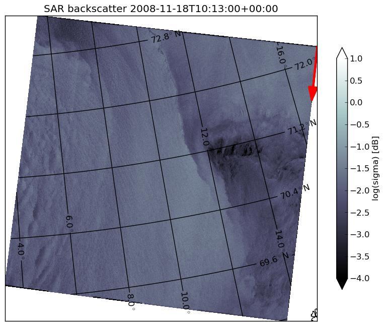
17 The Bjørnøya lows 16.th to 18.th November 2008
18 The Bjørnøya low: 18 utc 21 utc 19:30 utc Shear zone ~ 2-3 km, increase time ~ 5 minutes
.")
19 The Bjørnøya low 18 utc 21 utc 19:30 utc Bjørnøya synop: 38kt (19,5m/s). SAR winds: 25+ m/s


20 The 18.Nov low: Early detection? 10 utc 12 utc 14 utc 20 utc


21 Surface signature in the SAR? 10 utc
22 How about absolute wind speed? How good is the absolute wind speed?
23 Rapid increase in winds? Distance ~ 5 km Frontal speed ~ 10 m/s Increase in 7 minutes!
24 Summary: SAR imaging of Polar Lows Important supplement to existing observational data Excellent source of surface wind pattern Absolute wind uncertain Imprints on the sea surface (as opposed to AVHRR) Earlier detection? Polar low dissipation? As of 2012 not sufficient coverage for operational use Sentinel 1, 2 and 3 ( ) Meteorologisk institutt met.no

25 Thanks for the attention! Foto: Gunnar Mellem

26 The 16.th november 2008 case
Synthetic Aperture Radar imaging of Polar Lows
 Oslo Polar Low workshop 21-22 May 2012 Extended abstract Synthetic Aperture Radar imaging of Polar Lows Birgitte Furevik, Gunnar Noer and Johannes Röhrs met.no Forecasting polar lows is to a large degree
DEVELOPMENT AND VALIDATION OF A SAR WIND EMULATOR
 The Nansen Environmental and Remote Sensing Center a non-profit research institute affiliated with the University of Bergen Thormøhlensgate 47, N-5006 Bergen Norway NERSC Technical Report no. 304 DEVELOPMENT
Validation of 12.5 km Resolution Coastal Winds. Barry Vanhoff, COAS/OSU Funding by NASA/NOAA
 Validation of 12.5 km Resolution Coastal Winds Barry Vanhoff, COAS/OSU Funding by NASA/NOAA Outline Part 1: Determining empirical land mask Characterizing σ 0 near coast Part 2: Wind retrieval using new
Development of SAR-Derived Ocean Surface Winds at NOAA/NESDIS
 Development of SAR-Derived Ocean Surface Winds at NOAA/NESDIS Pablo Clemente-Colón, William G. Pichel, NOAA/NESDIS Frank M. Monaldo, Donald R. Thompson The Johns Hopkins University Applied Physics Laboratory
Monitoring Conditions Offshore with Satellites
 Downloaded from orbit.dtu.dk on: Dec 15, 2017 Monitoring Conditions Offshore with Satellites Karagali, Ioanna; Hasager, Charlotte Bay; Badger, Merete; Bingöl, Ferhat; Ejsing Jørgensen, Hans Publication
Reprocessed QuikSCAT (V04) Wind Vectors with Ku-2011 Geophysical Model Function
 Wind Vectors with Ku-2011 Geophysical Model Function") Reprocessed QuikSCAT (V04) Wind Vectors with Ku-2011 Geophysical Model Function Lucrezia Ricciardulli and Frank Wentz Introduction In April 2011, we reprocessed the QuikSCAT ocean wind vectors using a
Reprocessed QuikSCAT (V04) Wind Vectors with Ku-2011 Geophysical Model Function Lucrezia Ricciardulli and Frank Wentz Introduction In April 2011, we reprocessed the QuikSCAT ocean wind vectors using a
High resolution wind fields over the Black Sea derived from Envisat ASAR data using an advanced wind retrieval algorithm
 High resolution wind fields over the Black Sea derived from Envisat ASAR data using an advanced wind retrieval algorithm Werner Alpers (1), Alexis Mouche (2), Andrei Yu. Ivanov (3), and Burghard Brümmer
ON THE USE OF DOPPLER SHIFT FOR SAR WIND RETRIEVAL
 ON THE USE OF DOPPLER SHIFT FOR SAR WIND RETRIEVAL K-F. Dagestad 1, A. Mouche 2, F. Collard 2, M. W. Hansen 1 and J. Johannessen 1 (1) Nansen Environmental and Remote Censing Center, Thormohlens gt 47,
Analyses of Scatterometer and SAR Data at the University of Hamburg
 Analyses of Scatterometer and SAR Data at the University of Hamburg Wind, Waves, Surface Films and Rain ГАДЕ, Мартин Хорстович (aka Martin Gade) Institut für Meereskunde, Universität Hamburg, Германия
Cross-Calibrating OSCAT Land Sigma-0 to Extend the QuikSCAT Land Sigma-0 Climate Record
 Cross-Calibrating OSCAT Land Sigma-0 to Extend the QuikSCAT Land Sigma-0 Climate Record David G. Long Department of Electrical and Computer Engineering Brigham Young University May 2013 0 Scatterometer
Introduction EU-Norsewind
 Satellite winds in EU-Norsewind Charlotte Bay Hasager, Risø DTU, Denmark Alexis Mouche, CLS, France Merete Badger, Poul Astrup & Morten Nielsen, Risø DTU, Denmark Romain Husson, ESA Introduction EU-Norsewind
STUDY OF LOCAL WINDS IN MOUNTAINOUS COASTAL AREAS BY MULTI- SENSOR SATELLITE DATA
 STUDY OF LOCAL WINDS IN MOUNTAINOUS COASTAL AREAS BY MULTI- SENSOR SATELLITE DATA Werner Alpers Institute of Oceanography, University of Hamburg, Bundesstrasse 53, D-20146 Hamburg, Germany E-mail: alpers@ifm.uni-hamburg.de
Validation of 12.5 km and Super-High Resolution (2-5 km)
") Coastal and Orographic Wind Analyses from High Resolution QuikSCAT and SeaWinds Measurements M.H. Freilich, COAS/OSU D.B. Chelton, COAS/OSU D.G. Long, BYU Clive Dorman, SIO Barry Vanhoff, COAS/OSU OVWST
Coastal and Orographic Wind Analyses from High Resolution QuikSCAT and SeaWinds Measurements M.H. Freilich, COAS/OSU D.B. Chelton, COAS/OSU D.G. Long, BYU Clive Dorman, SIO Barry Vanhoff, COAS/OSU OVWST
THE POLARIMETRIC CHARACTERISTICS OF BOTTOM TOPOGRAPHY RELATED FEATURES ON SAR IMAGES
 THE POLARIMETRIC CHARACTERISTICS OF BOTTOM TOPOGRAPHY RELATED FEATURES ON SAR IMAGES Taerim Kim Professor, Ocean System Eng. Dept. Kunsan University Miryong Dong San 68, Kunsan, Jeonbuk, Korea, trkim@kunsan.ac.kr
ERS-1/2 Scatterometer new products: mission reprocessing and data quality improvement
 ERS-1/2 Scatterometer new products: mission reprocessing and data quality improvement Giovanna De Chiara (1), Raffaele Crapolicchio (1), Pascal Lecomte (2) (1) Serco SpA Via Sciadonna 22-24 Frascati (Roma),
Flow separation and lee-waves in the marine atmosphere
 Flow separation and lee-waves in the marine atmosphere Det norske Videnskabs-Akademi 16 Oct. 2009 Bjørn Gjevik Universitetet i Oslo epost: bjorng@math.uio.no Flow separation and lee-waves in the marine
THE EFFECT OF RAIN ON ASCAT OBSERVATIONS OF THE SEA SURFACE RADAR CROSS SECTION USING SIMULTANEOUS 3-D NEXRAD RAIN MEASUREMENTS
 THE EFFECT OF RAIN ON ASCAT OBSERVATIONS OF THE SEA SURFACE RADAR CROSS SECTION USING SIMULTANEOUS 3-D NERAD RAIN MEASUREMENTS David E. Weissman Hofstra University Hempstead, New York 11549 Mark A. Bourassa
USING SATELLITE SAR IN OFFSHORE WIND RESOURCE ASSESSMENT
 USING SATELLITE SAR IN OFFSHORE WIND RESOURCE ASSESSMENT B. R. Furevik (1), C. B. Hasager (2), M. Nielsen (2), T. Hamre (1), B. H. Jørgensen (2), O. Rathmann (2), and O. M. Johannessen (1,3) (1) Nansen
HIGH RESOLUTION WIND FIELDS OVER THE BLACK SEA DERIVED FROM ENVISAT ASAR DATA USING AN ADVANCED WIND RETRIEVAL ALGORITHM
 HIGH RESOLUTION WIND FIELDS OVER THE BLACK SEA DERIVED FROM ENVISAT ASAR DATA USING AN ADVANCED WIND RETRIEVAL ALGORITHM Werner Alpers (1), Alexis Mouche (2), Andrei Yu. Ivanov (3), Burghard Brümmer (4)
Using several data sources for offshore wind resource assessment
 Author manuscript, published in ", Copenhagen : Denmark (2005)" Ben Ticha M. B., Ranchin T., Wald L., Using several data sources for offshore wind resource assessment, 2005, Using several data sources
The Sea surface KInematics Multiscale (SKIM)
") The Sea surface KInematics Multiscale () proposal for ESA EE9 the team : https://www.facebook.com/4ee9 http://tinyurl.com/onrg http://www.umr-lops.fr/projets/projets-actifs/ 14 years of Doppler oceanography:
The Sea surface KInematics Multiscale () proposal for ESA EE9 the team : https://www.facebook.com/4ee9 http://tinyurl.com/onrg http://www.umr-lops.fr/projets/projets-actifs/ 14 years of Doppler oceanography:
LAMPEDUSA C B TRIPOLI
 ITALY SRR LAMPEDUSA 0 60 120 KILOMETERS MALTA SRR NATO MARITIME SURVEILLANCE AREA AS OF MARCH 23, 2011 D C B NATO MARITIME SURVEILLANCE AREA AS OF APRIL 8, 2011 A LIBYA SRR E TRIPOLI EXCERPT FROM: REPORT
SPATIAL AND TEMPORAL VARIATIONS OF INTERNAL WAVES IN THE NORTHERN SOUTH CHINA SEA
 SPATIAL AND TEMPORAL VARIATIONS OF INTERNAL WAVES IN THE NORTHERN SOUTH CHINA SEA Weigen Huang (1), Johnny Johannessen (2,3), Werner Alpers (4) Jingsong Yang (1), Xilin Gan (1) (1) Second Institute of
ERS WAVE MISSION REPROCESSING- QC SUPPORT ENVISAT MISSION EXTENSION SUPPORT
 REPORT 8/2011 ISBN 978-82-7492-248-8 ISSN 1890-5218 ERS WAVE MISSION REPROCESSING- QC SUPPORT ENVISAT MISSION EXTENSION SUPPORT - Annual Report 2010 Author (s): Harald Johnsen (Norut), Fabrice Collard
Impact of the loss of QuikSCAT on National Hurricane Center operations: Current mitigation efforts and future plans
 Impact of the loss of QuikSCAT on National Hurricane Center operations: Current mitigation efforts and future plans Rick Danielson1 and Mike Brennan NOAA/NWS/NCEP National Hurricane Center 1 UCAR visiting
Offshore wind mapping Mediterranean area using SAR
 Downloaded from orbit.dtu.dk on: Jan 12, 2019 Offshore wind mapping Mediterranean area using SAR Calaudi, Rosamaria; Arena, Felice; Badger, Merete; Sempreviva, Anna Maria Published in: Energy Procedia
J4.2 AUTOMATED DETECTION OF GAP WIND AND OCEAN UPWELLING EVENTS IN CENTRAL AMERICAN GULF REGIONS
 J4.2 AUTOMATED DETECTION OF GAP WIND AND OCEAN UPWELLING EVENTS IN CENTRAL AMERICAN GULF REGIONS Xiang Li*, University of Alabama in Huntsville Huntsville, AL D. K. Smith Remote Sensing Systems Santa Rosa,
PRELIMINARY STUDY ON DEVELOPING AN L-BAND WIND RETRIEVAL MODEL FUNCTION USING ALOS/PALSAR
 PRELIMINARY STUDY ON DEVELOPING AN L-BAND WIND RETRIEVAL MODEL FUNCTION USING ALOS/PALSAR Osamu Isoguchi, Masanobu Shimada Earth Observation Research Center, Japan Aerospace Exploration Agency (JAXA) 2-1-1
The Ice Contamination Ratio Method: Accurately Retrieving Ocean Winds Closer to the Sea Ice Edge While Eliminating Ice Winds
 The Ice Contamination Ratio Method: Accurately Retrieving Ocean Winds Closer to the Sea Ice Edge While Eliminating Ice Winds David Long Department of Electrical and Computer Engineering Brigham Young University
Sentinel-1A Ocean Level-2 Products Validation Strategy
 Sentinel-1A Ocean Level-2 Products Validation Strategy Sentinel-1 Mission Performance Centre ESL L2 Team and Ocean Data Lab G.Hajduch (1), A.Mouche (2), P.Vincent (1), R.Husson (1), H.Johnsen (3), F.Collard
SEA SURFACE TEMPERATURE RETRIEVAL USING TRMM MICROWAVE IMAGER SATELLITE DATA IN THE SOUTH CHINA SEA
 SEA SURFACE TEMPERATURE RETRIEVAL USING TRMM MICROWAVE IMAGER SATELLITE DATA IN THE SOUTH CHINA SEA Mohd Ibrahim Seeni Mohd and Mohd Nadzri Md. Reba Faculty of Geoinformation Science and Engineering Universiti
Aquarius Sca+erometer Calibra3on
 Aquarius Sca+erometer Calibra3on Fore, A., Neumann, G., Freedman, A., Chaubell, M., Tang, W., Hayashi, A., and Yueh, S. 217 California Ins3tute of Technology, Government Sponsorship acknowledged Aquarius
Assessing the quality of Synthetic Aperture Radar (SAR) wind retrieval in coastal zones using multiple Lidars
 wind retrieval in coastal zones using multiple Lidars") Assessing the quality of Synthetic Aperture Radar (SAR) wind retrieval in coastal zones using multiple Lidars Tobias Ahsbahs Merete Badger, Ioanna Karagali, Xiaoli Larsen What is the coastal zone? Coastal
Assessing the quality of Synthetic Aperture Radar (SAR) wind retrieval in coastal zones using multiple Lidars Tobias Ahsbahs Merete Badger, Ioanna Karagali, Xiaoli Larsen What is the coastal zone? Coastal
High resolution wind retrieval for SeaWinds
 High resolution wind retrieval for SeaWinds David G. Long and Jeremy B. Luke Brigham Young University, 459 Clyde Building, Provo, UT 84602, USA ABSTRACT The SeaWinds instrument on the QuikSCAT satellite
IMPROVED BAYESIAN WIND VECTOR RETRIEVAL SCHEME USING ENVISAT ASAR DATA: PRINCIPLES AND VALIDATION RESULTS
 IMPROVED BAYESIAN WIND VECTOR RETRIEVAL SCHEME USING ENVISAT ASAR DATA: PRINCIPLES AND VALIDATION RESULTS Vincent Kerbaol (1), and the SAR Ocean Wind, Waves and Currents Team (1) BOOST Technologies, 115
Offshore wind resource mapping in Europe from satellites
 Offshore wind resource mapping in Europe from satellites Charlotte Bay Hasager Seminar at University of Auckland, Dept. of Physics 1 April 2015 Content DTU Wind Energy Offshore wind turbines New European
TRMM TMI and AMSR-E Microwave SSTs
 TMI and AMSR-E Microwave SSTs Chelle Gentemann, Frank Wentz, & Peter Ashcroft Gentemann@remss.com www.remss.com TMI/AMSR-E MW SST algorithm development Validation Results Sensor Issues Useful for Climate
Polar Activities at DLR Maritime Security Lab Bremen in the Projects EISTAK and EMS
 Polar Activities at DLR Maritime Security Lab Bremen in the Projects EISTAK and EMS Susanne Lehner, Anja Frost, Rudolf Ressel German Aerospace Center Chart 2 Maritime Security Lab in Bremen German Aerospace
THE QUALITY OF THE ASCAT 12.5 KM WIND PRODUCT
 THE QUALITY OF THE ASCAT 12.5 KM WIND PRODUCT Jur Vogelzang, Ad Stoffelen, Maria Belmonte, Anton Verhoef, and Jeroen Verspeek Royal Netherlands Meteorological Institute, Wilhelminalaan 10, 3732 GK, De
Kelvin waves as observed by Radiosondes and GPS measurements and their effects on the tropopause structure: Long-term variations
 Kelvin waves as observed by Radiosondes and GPS measurements and their effects on the tropopause structure: Long-term variations M. Venkat Ratnam and T. Tsuda Research Institute for Sustainable Humanosphere
On the assimilation of SAR wave spectra of S-1A in the wave model MFWAM
 On the assimilation of SAR wave spectra of S-1A in the wave model MFWAM Lotfi Aouf and Alice Dalphinet Météo-France, Département Marine et Océanographie,Toulouse 14 th wave forecasting and hindcasting,
Characterization of Boundary-Layer Meteorology During DISCOVER-AQ
 Characterization of Boundary-Layer Meteorology During DISCOVER-AQ Daniel M. Alrick and Clinton P. MacDonald Sonoma Technology, Inc. Gary A. Morris St. Edward s University for Texas Air Quality Research
Atmospheric Waves James Cayer, Wesley Rondinelli, Kayla Schuster. Abstract
 Atmospheric Waves James Cayer, Wesley Rondinelli, Kayla Schuster Abstract It is important for meteorologists to have an understanding of the synoptic scale waves that propagate thorough the atmosphere
FUSION OF SYNTHETIC APERTURE RADAR AND OPTICAL SATELLITE DATA FOR UNDERWATER TOPOGRAPHY ESTIMATION IN COASTAL AREAS
 FUSION OF SYNTHETIC APERTURE RADAR AND OPTICAL SATELLITE DATA FOR UNDERWATER TOPOGRAPHY ESTIMATION IN COASTAL AREAS Andrey L. Pleskachevsky (1), Susanne Lehner (1) (1) German Aerospace Centre (DLR), Remote
Jackie May* Mark Bourassa. * Current affilitation: QinetiQ-NA
 Jackie May* Mark Bourassa * Current affilitation: QinetiQ-NA Background/Motivation In situ observations (ships and buoys) are used to validate satellite observations Problems with comparing data Sparseness
The Effects of Gap Wind Induced Vorticity, the ITCZ, and Monsoon Trough on Tropical Cyclogenesis
 The Effects of Gap Wind Induced Vorticity, the ITCZ, and Monsoon Trough on Tropical Cyclogenesis Heather M. Holbach and Mark A. Bourassa Center for Ocean-Atmospheric Prediction Studies Department of Earth,
Exercise: Satellite Imagery Analysis. 29 June 2016 Japan Meteorological Agency
 Exercise: Satellite Imagery Analysis 29 June 2016 Japan Meteorological Agency Contents 1. Fog/Stratiform Cloud 2. Cb (Cumulonimbus)/Cg (Cumulus congestus) 3. Upper-level Flow Jet stream, upper trough,
QuikScat/Seawinds Sigma-0 Radiometric and Location Accuracy Requirements for Land/Ice Applications
 Brigham Young University Department of Electrical and Computer Engineering 459 Clyde Building Provo, Utah 84602 QuikScat/Seawinds Sigma-0 Radiometric and Location Accuracy Requirements for Land/Ice Applications
Central American Pacific Coast
 Overview The Pacific coast of Central America extends approximately 3700 km from central Mexico (20 o N, 106 o W) to the edge of South America (7 o N, 78 o W). A significant continental shelf exists from
OBSERVATIONS OF ATMOSPHERIC GRAVITY WAVES OVER THE CHINESE SEAS BY SPACEBORNE SYNTHETIC APERTURE RADAR
 OBSERVATIONS OF ATMOSPHERIC GRAVITY WAVES OVER THE CHINESE SEAS BY SPACEBORNE SYNTHETIC APERTURE RADAR W. Alpers (1), W. Huang (2), G. Xilin (2) (1) Center for Marine and Climate Research, Institute of
Deborah K. Smith, Frank J. Wentz, and Carl A. Mears Remote Sensing Systems
 JP 4.9 RESULTS OF QUIKSCAT HIGH WIND DATA VALIDATION Deborah K. Smith, Frank J. Wentz, and Carl A. Mears Remote Sensing Systems ABSTRACT Traditional validation of satellite-derived winds includes comparison
IMPROVED OIL SLICK IDENTIFICATION USING CMOD5 MODEL FOR WIND SPEED EVALUATION ON SAR IMAGES
 IMPROVED OIL SLICK IDENTIFICATION USING CMOD5 MODEL FOR WIND SPEED EVALUATION ON SAR IMAGES H.KHENOUCHI & Y. SMARA University of Sciences and Technology Houari Boumediene (USTHB). Faculty of Electronics
HIGH RESOLUTION WIND RETRIEVAL FOR SEAWINDS ON QUIKSCAT. Jeremy B. Luke. A thesis submitted to the faculty of. Brigham Young University
 HIGH RESOLUTION WIND RETRIEVAL FOR SEAWINDS ON QUIKSCAT by Jeremy B. Luke A thesis submitted to the faculty of Brigham Young University in partial fulfillment of the requirements for the degree of Master
Comparison of data and model predictions of current, wave and radar cross-section modulation by seabed sand waves
 Comparison of data and model predictions of current, wave and radar cross-section modulation by seabed sand waves Cees de Valk, ARGOSS Summary SAR Imaging of seabed features Seabed Sand waves Objectives
Wind Atlas for the Gulf of Suez Satellite Imagery and Analyses
 Downloaded from orbit.dtu.dk on: Nov 09, 2017 Wind Atlas for the Gulf of Suez Satellite Imagery and Analyses Hasager, Charlotte Bay Publication date: 2003 Document Version Publisher's PDF, also known as
Wind Stress Working Group 2015 IOVWST Meeting Portland, OR
 Wind Stress Working Group 2015 IOVWST Meeting Portland, OR Summary of Research Topics, Objectives and Questions James B. Edson University of Connecticut SPURS Mooring, Farrar, WHOI Background Motivation
Swell (wind) fields obtained from Satellite Observation CLS Christian Ortega - Mission blue Journées Annuelles des Hydrocarbures 2013
 fields obtained from Satellite Observation CLS Christian Ortega - Mission blue Journées Annuelles des Hydrocarbures 2013") Swell (wind) fields obtained from Satellite Observation CLS Christian Ortega - cortega@cls.fr Mission blue Journées Annuelles des Hydrocarbures 2013 Purpose Develop new methodologies to obtain swell (wind)
Swell (wind) fields obtained from Satellite Observation CLS Christian Ortega - cortega@cls.fr Mission blue Journées Annuelles des Hydrocarbures 2013 Purpose Develop new methodologies to obtain swell (wind)
Advancements in scatterometer wind processing
 Advancements in scatterometer wind processing Ad.Stoffelen@knmi.nl Marcos Portabella Anton Verhoef Jeroen Verspeek Jur Vogelzang scat@knmi.nl www.knmi.nl/scatterometer Scatterometer work The scatterometer
Satellite information on ocean vector wind from Scatterometer data. Giovanna De Chiara
 Satellite information on ocean vector wind from Scatterometer data Giovanna De Chiara Why is Scatterometer important? The scatterometer measures the ocean surface winds (ocean wind vector). Ocean surface
Short-period gravity waves over a high-latitude observation site: Rothera, Antarctica
 Short-period gravity waves over a high-latitude observation site: Rothera, Antarctica K. Nielsen, D. Broutman, M. Taylor, D. Siskind, S. Eckermann, K. Hoppel, R. Hibbins, M. Jarvis, N. Mitchell, J. Russell
ECO 40 is a CLASS 40 Main dimensions of the boat
 11 marzo 2015 I condizionamenti dell ambiente sulla performance sportiva: come si vince un Olimpiade Aula Magna - Politecnico di Torino Corso Duca degli Abruzzi 24 ROMA OCEAN WORLD Paolo DE GIROLAMO -
OBSERVATION OF HURRICANE WINDS USING SYNTHETIC APERTURE RADAR
 OBSERVATION OF HURRICANE WINDS USING SYNTHETIC APERTURE RADAR Jochen Horstmann 1, Wolfgang Koch 1,DonaldR.Thompson 2, and Hans C. Graber 3 1 Institute for Coastal Research, GKSS Research Center, Geesthacht,
Low level coastal jet
 MetOcean analysis of a low-level coastal jet off the Norwegian coast. EERA DeepWind'2014 Deep Sea Offshore Wind R&D Conference, Trondheim, 22-24 January 2014 Harokopio University Konstantinos Christakos,
OCEAN vector winds from the SeaWinds instrument have
 IEEE GEOSCIENCE AND REMOTE SENSING LETTERS, VOL. 6, NO. 3, JULY 2009 413 Coastal Validation of Ultra-High Resolution Wind Vector Retrieval From QuikSCAT in the Gulf of Maine A. M. Plagge, Student Member,
An Atlas of Oceanic Internal Solitary Waves (February 2004) by Global Ocean Associates Prepared for Office of Naval Research Code 322 PO
 by Global Ocean Associates Prepared for Office of Naval Research Code 322 PO") Overview covers approximately 2200 km of coast from Kenya to the tip of Somalia (approximately 39 o E, 4 o S to 51 o E, 12 o N)(Figure 1). Internal wave activity has been observed in the area the near
Overview covers approximately 2200 km of coast from Kenya to the tip of Somalia (approximately 39 o E, 4 o S to 51 o E, 12 o N)(Figure 1). Internal wave activity has been observed in the area the near
Utilizing Vessel Based Mobile LiDAR & Bathymetry Survey Techniques for Survey of Four Southern California Breakwaters
 Utilizing Vessel Based Mobile LiDAR & Bathymetry Survey Techniques for Survey of Four Southern California Breakwaters Western Dredging Association: Pacific Chapter September 2012 Insert: Pipe Location
On the Quality of HY-2A Scatterometer Winds
 On the Quality of HY-2A Scatterometer Winds W. Lin (ICM-CSIC) M. Portabella (ICM-CSIC) A. Stoffelen (KNMI) A. Verhoef (KNMI) Youguang Zhang (NSOAS) Mingsen Lin (NSOAS) Shuyan Lang (NSOAS) Juhong Zou (NSOAS)
Geophysical Model Functions for the Retrieval of Ocean Surface Winds
 Geophysical Model Functions for the Retrieval of Ocean Surface Winds Donald R. Thompson and Frank M. Monaldo Johns Hopkins University Applied Physics Laboratory 11100 Johns Hopkins Road, Laurel, MD 20708
SATELLITE REMOTE SENSING APPLIED TO OFF-SHORE WIND ENERGY
 EARSeL eproceedings 13, 1/014 1 SATELLITE REMOTE SENSING APPLIED TO OFF-SHORE WIND ENERGY Sara Venafra 1, Marco Morelli, and Andrea Masini 1 1. Flyby S.r.l., Livorno, Italy; {sara.venafra / andrea.masini}(at)flyby.it.
EVALUATION OF ENVISAT ASAR WAVE MODE RETRIEVAL ALGORITHMS FOR SEA-STATE FORECASTING AND WAVE CLIMATE ASSESSMENT
 EVALUATION OF ENVISAT ASAR WAVE MODE RETRIEVAL ALGORITHMS FOR SEA-STATE FORECASTING AND WAVE CLIMATE ASSESSMENT F.J. Melger ARGOSS, P.O. Box 61, 8335 ZH Vollenhove, the Netherlands, Email: info@argoss.nl
Synthetic aperture radar observations of sea surface signatures of atmospheric gravity waves over Southeast Asian coastal waters
 Synthetic aperture radar observations of sea surface signatures of atmospheric gravity waves over Southeast Asian coastal waters Werner Alpers Institute of Oceanography, University of Hamburg, Hamburg,
REMOTE SENSING APPLICATION in WIND ENERGY
 REMOTE SENSING APPLICATION in WIND ENERGY Siraj Ahmed Professor & Head Department of Mechanical Engineering Maulana Azad National Iinstitute of Technology Bhopal, India sirajahmed@manit.ac.in Contents
An Atlas of Oceanic Internal Solitary Waves (February 2004) by Global Ocean Associates Prepared for Office of Naval Research Code 322 PO
 by Global Ocean Associates Prepared for Office of Naval Research Code 322 PO") Overview covers approximately 5500 km of coast between Western Sahara (22 o N, 17 o W) and Angola (5 o S, 12 o E) (Figure 1). The continental shelf in the region varies significantly in width. The region
Overview covers approximately 5500 km of coast between Western Sahara (22 o N, 17 o W) and Angola (5 o S, 12 o E) (Figure 1). The continental shelf in the region varies significantly in width. The region
RAPid Image Exploitation Resource (RAPIER ) Ship Detection System
 Ship Detection System") RAPid Image Exploitation Resource (RAPIER ) Ship Detection System Heidi L. Buck Head, Advanced Analysis Systems, Code 56220 SPAWAR Systems Center, Pacific Phone: 619-553-6626 NIPR: heidi.buck@navy.mil
RAPid Image Exploitation Resource (RAPIER ) Ship Detection System Heidi L. Buck Head, Advanced Analysis Systems, Code 56220 SPAWAR Systems Center, Pacific Phone: 619-553-6626 NIPR: heidi.buck@navy.mil
ASCAT Level 2 Soil Moisture Reprocessing Phase 1 - Dataset Description
 ASCAT Level 2 Soil Moisture Reprocessing Phase 1 - Dataset Description Doc.No. : Issue : v3 Date : 4 November 2009 WBS : EUMETSAT Eumetsat-Allee 1, D-64295 Darmstadt, Germany Tel: +49 6151 807-7 Fax: +49
SENSOR SYNERGY OF ACTIVE AND PASSIVE MICROWAVE INSTRUMENTS FOR OBSERVATIONS OF MARINE SURFACE WINDS
 SENSOR SYNERGY OF ACTIVE AND PASSIVE MICROWAVE INSTRUMENTS FOR OBSERVATIONS OF MARINE SURFACE WINDS N. Ebuchi Institute of Low Temperature Science, Hokkaido University, N19-W8, Kita-ku, Sapporo 060-0819,
Department of Meteorology. An Analysis of Sea Breezes on the South Coast of England and Evidence of Pre- and Post-Frontal Waves at the Surface.
 Department of Meteorology An Analysis of Sea Breezes on the South Coast of England and Evidence of Pre- and Post-Frontal Waves at the Surface. GILLEAN J KEITH A dissertation submitted in partial fulfilment
Gravity waves and bores. Material kindly provided by Dr. Steven Koch GSD NOAA (Boulder, CO)
") Gravity waves and bores Material kindly provided by Dr. Steven Koch GSD NOAA (Boulder, CO) Presented at Iowa State University 11 April 2005 What is a gravity wave? An oscillation caused by the displacement
Gravity waves and bores Material kindly provided by Dr. Steven Koch GSD NOAA (Boulder, CO) Presented at Iowa State University 11 April 2005 What is a gravity wave? An oscillation caused by the displacement
Wind Data Verification Report Arriga 50m
 Page 1 of 11 Site Name Site Details 9531 - Arriga 5m Arriga 5m Date/Time of report generation 27/11/212 4:22 PM Site Number 9531 Mast Height 5m Mast Location 32568 E 811256 N Coordinate System UTM 55K
Dr S.Gomathinayagam Executive Director CWET, Chennai, India. web: cwet.res.in
 Dr S.Gomathinayagam Executive Director CWET, Chennai, India ed@cwet.res.in web: cwet.res.in Advantages of Offshore over Onshore Advantages of Offshore over Onshore SPECIALIST SERVICES TO THE OFFSHORE WIND
Application of a new algorithm using Doppler information to retrieve complex wind fields over the Black Sea from ENVISAT SAR images
 1 International Journal Of Remote Sensing 2015, Volume 36 Issue 3 Pages 863-881 http://dx.doi.org/10.1080/01431161.2014.999169 http://archimer.ifremer.fr/doc/00253/36390/ 2015 Taylor & Francis Achimer
Satellite information for wind energy applications
 Downloaded from orbit.dtu.dk on: Oct 01, 2018 Satellite information for wind energy applications Nielsen, Morten; Astrup, Poul; Hasager, Charlotte Bay; Barthelmie, R.J.; Pryor, S.C. Publication date: 2004
Analyzing Surface Wind Fields Near Lower Cook Inlet And Kodiak Waters Using SAR
 J4.11 Analyzing Surface Wind Fields Near Lower Cook Inlet And Kodiak Waters Using SAR Eddie Zingone Weather Forecast Office, National Weather Service, Anchorage Alaska Gary L. Hufford Alaska Region Headquarters,
MISR CMVs. Roger Davies and Aaron Herber Physics Department
 MISR CMVs Roger Davies and Aaron Herber Physics Department Acknowledgements: MISR Science and Data Processing Team (especially Catherine Moroney and Mike Garay) From the AGU Fall Meeting 2009 MISR and
Bias assessment of MODIS/MISR winds
 Bias assessment of MODIS/MISR winds Feng Lu, Yixuan Shou, Xiaohu Zhang, Jianmin Xu Office of System Development, National Satellite Meteorological Center/CMA 13th International Winds Workshop (IWW13),
Global Wind Speed Retrieval From SAR
 IEEE TRANSACTIONS ON GEOSCIENCE AND REMOTE SENSING, VOL. 41, NO. 10, OCTOBER 2003 2277 Global Wind Speed Retrieval From SAR Jochen Horstmann, Helmut Schiller, Johannes Schulz-Stellenfleth, and Susanne
Sub-km grid NWP for regions with complex orography
 Sub-km grid NWP for regions with complex orography Challenges with station forecast Experimental 750-metre HARMONIE-AROME @ DMI Xiaohua Yang, DMI Operational experiences Since late 2016, DMI and IMO operate
SIMON YUEH, WENQING TANG, ALEXANDER FORE, AND JULIAN CHAUBELL JPL-CALTECH, PASADENA, CA, USA GARY LAGERLOEF EARTH AND SPACE RESEARCH, SEATTLE, WA, US
 Applications of L-Band Scatterometry and Radiometry to Aquarius and SMAP SIMON YUEH, WENQING TANG, ALEXANDER FORE, AND JULIAN CHAUBELL JPL-CALTECH, PASADENA, CA, USA GARY LAGERLOEF EARTH AND SPACE RESEARCH,
Wind Direction Analysis over the Ocean using SAR Imagery
 Journal of Information & Computational Science 5: 1 (2008) 223-231 Available at http: www.joics.com Wind Direction Analysis over the Ocean using SAR Imagery Kaiguo Fan a,b,, Weigen Huang a, Mingxia He
WindSat Applications for Weather Forecasters and Data Assimilation
 WindSat Applications for Weather Forecasters and Data Assimilation Thomas Lee, James Goerss, Jeffrey Hawkins, Joseph Turk Naval Research Laboratory 7 Grace Hopper Avenue Monterey CA Zorana Jelenak, Paul
Extreme waves in the ECMWF operational wave forecasting system. Jean-Raymond Bidlot Peter Janssen Saleh Abdalla
 Extreme waves in the ECMWF operational wave forecasting system Jean-Raymond Bidlot Peter Janssen Saleh Abdalla European Centre for Medium range Weather Forecasts Shinfield Park, RG 9AX, Reading, United
ERGS are large expanses of sand in the desert. Aeolian
 1164 IEEE TRANSACTIONS ON GEOSCIENCE AND REMOTE SENSING, VOL. 45, NO. 5, MAY 2007 Spatial and Temporal Behavior of Microwave Backscatter Directional Modulation Over the Saharan Ergs Haroon Stephen, Member,
ADVANCES ON WIND ENERGY RESOURCE MAPPING FROM SAR
 ADVANCES ON WIND ENERGY RESOURCE MAPPING FROM SAR C.B. Hasager, M. Nielsen, M.B. Christiansen, R. Barthelmie, P. Astrup Risoe National Laboratory, Wind Energy Department, Frederiksborgvej 399, DK-4000
The technical support for global validation of ERS Wind and Wave Products at ECMWF
 The technical support for global validation of ERS Wind and Wave Products at ECMWF (July 27 - June 28) November 28 Authors: Saleh Abdalla and Hans Hersbach Final report for ESA contract 291/7/I-EC Series:
Using Sentinel-1 SAR satellites to map wind speed variation across offshore wind farm clusters
 Journal of Physics: Conference Series PAPER OPEN ACCESS Using Sentinel-1 SAR satellites to map wind speed variation across offshore wind farm clusters To cite this article: S F James 2017 J. Phys.: Conf.
NONLINEAR INTERNAL WAVES IN THE SOUTH CHINA SEA
 25 th ACRS 2004 Chiang Mai, Thailand xxx NONLINEAR INTERNAL WAVES IN THE SOUTH CHINA SEA Ming-Kuang Hsu Professor, Kuang Wu Institute of Technology, Taipei, Taiwan, R.O.C. Hsumk@kwit.edu.tw Antony K. Liu
RZGM Wind Atlas of Aegean Sea with SAR data
 RZGM2013-14 - Wind Atlas of Aegean Sea with SAR data Ferhat Bingöl 1, Charlotte B. Hassager 2, Merete Badger 3 and Jake Badger 4 Denmark Technical University, Wind Energy, Frederiksborgvej 399 4000 Roskilde,
CHANGE OF THE BRIGHTNESS TEMPERATURE IN THE MICROWAVE REGION DUE TO THE RELATIVE WIND DIRECTION
 JP4.12 CHANGE OF THE BRIGHTNESS TEMPERATURE IN THE MICROWAVE REGION DUE TO THE RELATIVE WIND DIRECTION Masanori Konda* Department of Geophysics, Graduate School of Science, Kyoto University, Japan Akira
Towards an Optimal Inversion Method. for SAR Wind Retrieval 1
 Towards an Optimal Inversion Method for SAR Wind Retrieval 1 M. Portabella *, A. Stoffelen *, and J. A. Johannessen ** * KNMI, Postbus 201, 3730 AE De Bilt, The Netherlands ** NERSC, Edvard Griegsvei 3a,
OPERATIONAL AMV PRODUCTS DERIVED WITH METEOSAT-6 RAPID SCAN DATA. Arthur de Smet. EUMETSAT, Am Kavalleriesand 31, D Darmstadt, Germany ABSTRACT
 OPERATIONAL AMV PRODUCTS DERIVED WITH METEOSAT-6 RAPID SCAN DATA Arthur de Smet EUMETSAT, Am Kavalleriesand 31, D-64295 Darmstadt, Germany ABSTRACT EUMETSAT started its Rapid Scanning Service on September