Validation of 12.5 km and Super-High Resolution (2-5 km)
|
|
|
- Jody Rogers
- 5 years ago
- Views:
Transcription
1 Coastal and Orographic Wind Analyses from High Resolution QuikSCAT and SeaWinds Measurements M.H. Freilich, COAS/OSU D.B. Chelton, COAS/OSU D.G. Long, BYU Clive Dorman, SIO Barry Vanhoff, COAS/OSU OVWST Meeting, 5-7 July 2006
2 Project Overview Geophysical Analyses Characterize orographic/coastal wind features Scales, locations, relation to synoptic conditions, divergence/curl Examine wind forcing of California Current System using multi-year QuiKSCAT (+SWS) Role of wind forcing in maintaining poleward integrated xport Validation of 12.5 km and Super-High Resolution (2-5 km) wind retrievals Advanced buoy comparison analyses Use of WEST near-coastal research buoy array (direct derivative field comparison) Impact-based Land Mask Relies critically on existence of 6+ year QuikSCAT data set Allows construction of backscatter estimates from uncontaminated slices Early start thanks to NOAA/NESDIS R and O support


3 June-Sept (Summer) Stress Curl (25 km)
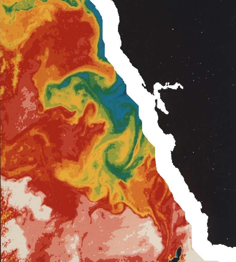
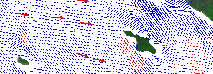
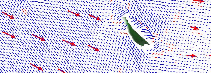
4 Summer CZCS Image of US West Coast Equatorward winds cause coastal upwelling -- Low SST near coast -- High productivity -- Complex air-sea interaction Temperature Pigment

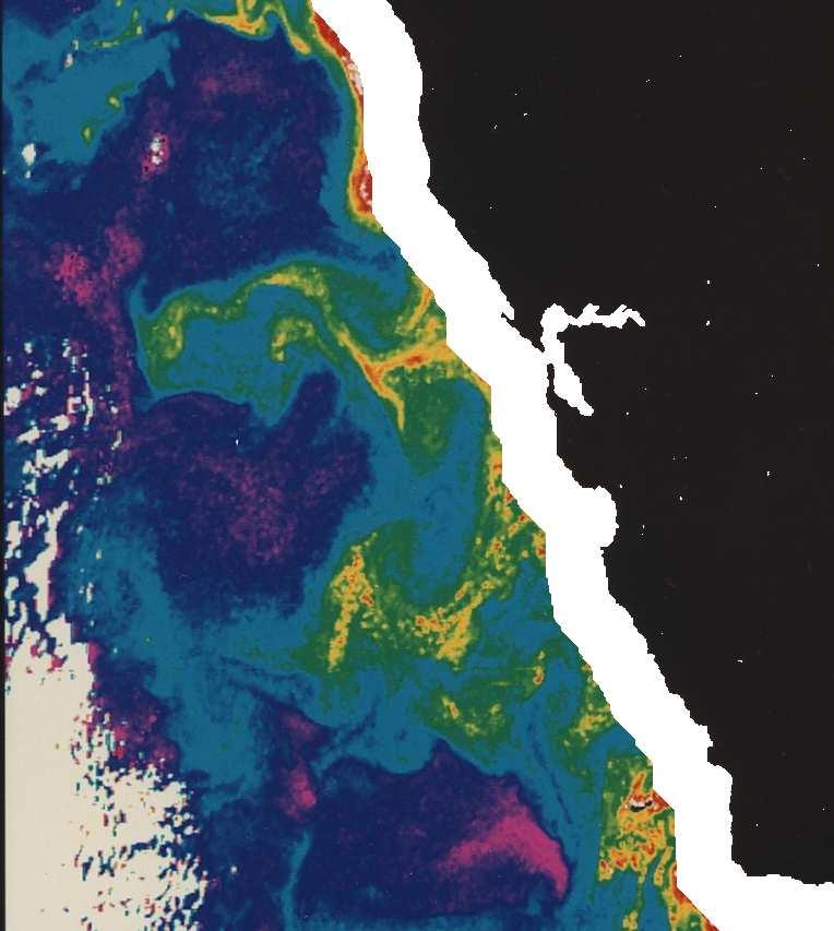
5 Effect of 30 km scatterometer land mask Temperature Pigment
6 25 April 2001
7
8

9
10
")
11 SIO WEST Buoy Locations (Bodega Bay, ) 2003)
12 Statistical Land Mask Determination Basic assumptions: Accurate wind scatterometer wind retrieval requires that temporal changes in scatterometer backscatter (σ o ) measurements result from changes in winds and thus changes in wind-generated ocean roughness Land-contaminated σ o (at fixed viewing geometry) will vary much less than wind-induced ocean σ o variability (even in the presence of atmospheric effects, seasonal vegetation, and snow/soil moisture variability) Approach: Approach: 6-year QuikSCAT mission provides many σ o measurements at each geographical location and from the same viewing geometry Each coastal geographical location has been imaged many times each from several different viewing geometries (slice orientation relative to coast); effect of land will vary with viewing geometry Calculate sample σ o distributions along coastal offshore-directed transects for fixed viewing geometry; σ o distributions should not vary with distance from coast when sufficiently offshore Calculate effective land mask for each geographical location, each beam (v-pol or h-pol), and each scatterometer viewing geometry (azimuth); this requires the long QuikSCAT data set for statistical stability/sampling
13 Example Calculation (THANKS TO NOAA FUNDING) Best-4 slices (~4 x 25 km resolution); o azimuth Transect off US West Coast, 50 o N Distribution width (std dev) used as metric Slice center Offshore distance

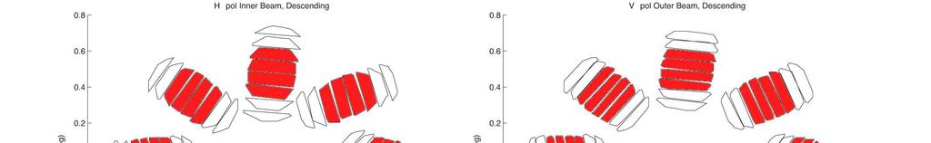
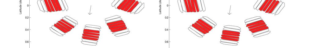
14 Middle-4 Slice Orientation after Ashcraft and Long, 2003, SPIE


15 Std Devs vs. Closest Offshore Distance (all-coast)
16 Median Std Devs vs. Offshore Distance (all-coast) cross parallel Slice Center Slice Closest Point


")
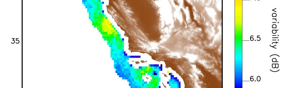

17 Std. Dev. vs. Location (V-pol, all azis, 20 km center mask)
18 Summary Study coastal and orographic wind features and ocean forcing US West Coast, high latitude islands Define scales, relations to synoptic conditions, (conditional) climatologies Validate 2 high resolution scatterometer data sets 12.5 km science processor ( HR ) km super-high resolution (David Long SHR ) NDBC near-coastal buoys and WEST buoy array ( ) Develop impact-based, statistical, σ o land mask Geographic as well as geometric Full-mission slice statistics (original L2B) finished for US West Coast km wide land mask seems likely NOAA R and O funding allowed early work will develop CONUS NRT mask Similar calculations will be applied to SHR σ o
19
20
21

22 5-year Mean Summer Wind Stress Curl from QuikSCAT Science Data mean June-Sept wind stress curl From QSCAT 25 km data NDBC buoy locations as Transition from negative offshore curl to strong positive nearshore curl is barely evident outside landmask; little data within Southern California Bight
Validation of 12.5 km Resolution Coastal Winds. Barry Vanhoff, COAS/OSU Funding by NASA/NOAA
 Validation of 12.5 km Resolution Coastal Winds Barry Vanhoff, COAS/OSU Funding by NASA/NOAA Outline Part 1: Determining empirical land mask Characterizing σ 0 near coast Part 2: Wind retrieval using new
Cross-Calibrating OSCAT Land Sigma-0 to Extend the QuikSCAT Land Sigma-0 Climate Record
 Cross-Calibrating OSCAT Land Sigma-0 to Extend the QuikSCAT Land Sigma-0 Climate Record David G. Long Department of Electrical and Computer Engineering Brigham Young University May 2013 0 Scatterometer
Wind Stress Working Group 2015 IOVWST Meeting Portland, OR
 Wind Stress Working Group 2015 IOVWST Meeting Portland, OR Summary of Research Topics, Objectives and Questions James B. Edson University of Connecticut SPURS Mooring, Farrar, WHOI Background Motivation
A. Bentamy 1, S. A. Grodsky2, D.C. Fillon1, J.F. Piollé1 (1) Laboratoire d Océanographie Spatiale / IFREMER (2) Univ. Of Maryland
 Laboratoire d Océanographie Spatiale / IFREMER (2) Univ. Of Maryland") Calibration and Validation of Multi-Satellite scatterometer winds A. Bentamy 1, S. A. Grodsky2, D.C. Fillon1, J.F. Piollé1 (1) Laboratoire d Océanographie Spatiale / IFREMER (2) Univ. Of Maryland Topics
Calibration and Validation of Multi-Satellite scatterometer winds A. Bentamy 1, S. A. Grodsky2, D.C. Fillon1, J.F. Piollé1 (1) Laboratoire d Océanographie Spatiale / IFREMER (2) Univ. Of Maryland Topics
The Ice Contamination Ratio Method: Accurately Retrieving Ocean Winds Closer to the Sea Ice Edge While Eliminating Ice Winds
 The Ice Contamination Ratio Method: Accurately Retrieving Ocean Winds Closer to the Sea Ice Edge While Eliminating Ice Winds David Long Department of Electrical and Computer Engineering Brigham Young University
Reprocessed QuikSCAT (V04) Wind Vectors with Ku-2011 Geophysical Model Function
 Wind Vectors with Ku-2011 Geophysical Model Function") Reprocessed QuikSCAT (V04) Wind Vectors with Ku-2011 Geophysical Model Function Lucrezia Ricciardulli and Frank Wentz Introduction In April 2011, we reprocessed the QuikSCAT ocean wind vectors using a
Reprocessed QuikSCAT (V04) Wind Vectors with Ku-2011 Geophysical Model Function Lucrezia Ricciardulli and Frank Wentz Introduction In April 2011, we reprocessed the QuikSCAT ocean wind vectors using a
The Effects of Gap Wind Induced Vorticity, the ITCZ, and Monsoon Trough on Tropical Cyclogenesis
 The Effects of Gap Wind Induced Vorticity, the ITCZ, and Monsoon Trough on Tropical Cyclogenesis Heather M. Holbach and Mark A. Bourassa Center for Ocean-Atmospheric Prediction Studies Department of Earth,
Impact of fine-scale wind stress curl structures on coastal upwelling dynamics : The Benguela system as a case of study.
 IOVWST Meeting May 21, 2015, Portland (OR) Impact of fine-scale wind stress curl structures on coastal upwelling dynamics : The Benguela system as a case of study. Fabien Desbiolles1,2, Bruno Blanke1,
Coastal Scatterometer Winds Working Group
 Coastal Scatterometer Winds Working Group IOVWST Meeting 2015 Portland, Oregon, USA Melanie Fewings Julia Figa Saldaña Bryan Stiles Steve Morey Dmitry Dukhovskoy Larry O Neill if you want to be added to
OCEAN vector winds from the SeaWinds instrument have
 IEEE GEOSCIENCE AND REMOTE SENSING LETTERS, VOL. 6, NO. 3, JULY 2009 413 Coastal Validation of Ultra-High Resolution Wind Vector Retrieval From QuikSCAT in the Gulf of Maine A. M. Plagge, Student Member,
THE QUALITY OF THE ASCAT 12.5 KM WIND PRODUCT
 THE QUALITY OF THE ASCAT 12.5 KM WIND PRODUCT Jur Vogelzang, Ad Stoffelen, Maria Belmonte, Anton Verhoef, and Jeroen Verspeek Royal Netherlands Meteorological Institute, Wilhelminalaan 10, 3732 GK, De
SENSOR SYNERGY OF ACTIVE AND PASSIVE MICROWAVE INSTRUMENTS FOR OBSERVATIONS OF MARINE SURFACE WINDS
 SENSOR SYNERGY OF ACTIVE AND PASSIVE MICROWAVE INSTRUMENTS FOR OBSERVATIONS OF MARINE SURFACE WINDS N. Ebuchi Institute of Low Temperature Science, Hokkaido University, N19-W8, Kita-ku, Sapporo 060-0819,
High resolution wind retrieval for SeaWinds
 High resolution wind retrieval for SeaWinds David G. Long and Jeremy B. Luke Brigham Young University, 459 Clyde Building, Provo, UT 84602, USA ABSTRACT The SeaWinds instrument on the QuikSCAT satellite
Development of SAR-Derived Ocean Surface Winds at NOAA/NESDIS
 Development of SAR-Derived Ocean Surface Winds at NOAA/NESDIS Pablo Clemente-Colón, William G. Pichel, NOAA/NESDIS Frank M. Monaldo, Donald R. Thompson The Johns Hopkins University Applied Physics Laboratory
Assessment and Analysis of QuikSCAT Vector Wind Products for the Gulf of Mexico: A Long-Term and Hurricane Analysis
 Sensors 2008, 8, 1927-1949 sensors ISSN 1424-8220 2008 by MDPI www.mdpi.org/sensors Full Research Paper Assessment and Analysis of QuikSCAT Vector Wind Products for the Gulf of Mexico: A Long-Term and
PRELIMINARY STUDY ON DEVELOPING AN L-BAND WIND RETRIEVAL MODEL FUNCTION USING ALOS/PALSAR
 PRELIMINARY STUDY ON DEVELOPING AN L-BAND WIND RETRIEVAL MODEL FUNCTION USING ALOS/PALSAR Osamu Isoguchi, Masanobu Shimada Earth Observation Research Center, Japan Aerospace Exploration Agency (JAXA) 2-1-1
J4.2 AUTOMATED DETECTION OF GAP WIND AND OCEAN UPWELLING EVENTS IN CENTRAL AMERICAN GULF REGIONS
 J4.2 AUTOMATED DETECTION OF GAP WIND AND OCEAN UPWELLING EVENTS IN CENTRAL AMERICAN GULF REGIONS Xiang Li*, University of Alabama in Huntsville Huntsville, AL D. K. Smith Remote Sensing Systems Santa Rosa,
Assessing the Accuracy of High Spatial Resolution Effort Data
 Assessing the Accuracy of High Spatial Resolution Effort Data Southwest Fisheries Science Center, Ecology Division Comparing VMS and Logbook Data in the California Groundfish Trawl Fishery Alice Thomas-Smyth,
THE SEAWINDS scatterometer was flown twice, once on
 IEEE TRANSACTIONS ON GEOSCIENCE AND REMOTE SENSING 1 Land-Contamination Compensation for QuikSCAT Near-Coastal Wind Retrieval Michael P. Owen and David G. Long, Fellow, IEEE Abstract The QuikSCAT scatterometer
The RSS WindSat Version 7 All-Weather Wind Vector Product
 2010 International Ocean Vector Winds Meeting Barcelona, Spain May 18 20, 2010 The RSS WindSat Version 7 All-Weather Wind Vector Product Thomas Meissner Lucrezia Ricciardulli Frank Wentz Outline 1. Overview:
Combining wind and rain in spaceborne scatterometer observations: modeling the splash effects in the sea surface backscattering coefficient
 Combining wind and rain in spaceborne scatterometer observations: modeling the splash effects in the sea surface backscattering coefficient F. Polverari (1,2,4), F. S. Marzano (1,2), L. Pulvirenti (3,1),
CHANGE OF THE BRIGHTNESS TEMPERATURE IN THE MICROWAVE REGION DUE TO THE RELATIVE WIND DIRECTION
 JP4.12 CHANGE OF THE BRIGHTNESS TEMPERATURE IN THE MICROWAVE REGION DUE TO THE RELATIVE WIND DIRECTION Masanori Konda* Department of Geophysics, Graduate School of Science, Kyoto University, Japan Akira
What determines the spatial pattern in summer upwelling trends on the U.S. West Coast?
 What determines the spatial pattern in summer upwelling trends on the U.S. West Coast? Hyodae Seo Woods Hole Oceanographic Institution (hseo@whoi.edu) Climate Trends and Projections in the Coastal Environment
Scales of Atmospheric Motion Scale Length Scale (m) Time Scale (sec) Systems/Importance Molecular (neglected)
 Time Scale (sec) Systems/Importance Molecular (neglected)") Supplement Wind, Fetch and Waves Scales of Atmospheric Motion Scale Length Scale (m) Time Scale (sec) Systems/Importance Molecular 10-7 - 10-2 10-1 (neglected) Coriolis not important Turbulent 10-2 10
Supplement Wind, Fetch and Waves Scales of Atmospheric Motion Scale Length Scale (m) Time Scale (sec) Systems/Importance Molecular 10-7 - 10-2 10-1 (neglected) Coriolis not important Turbulent 10-2 10
Review of Equivalent Neutral Winds and Stress
 Review of Equivalent Neutral Winds and Stress Mark A. Bourassa Center for Ocean-Atmospheric Prediction Studies, Geophysical Fluid Dynamics Institute & Department of Earth, Ocean and Atmospheric Science
TRMM TMI and AMSR-E Microwave SSTs
 TMI and AMSR-E Microwave SSTs Chelle Gentemann, Frank Wentz, & Peter Ashcroft Gentemann@remss.com www.remss.com TMI/AMSR-E MW SST algorithm development Validation Results Sensor Issues Useful for Climate
Observations and Modeling of Coupled Ocean-Atmosphere Interaction over the California Current System
 Observations and Modeling of Coupled Ocean-Atmosphere Interaction over the California Current System Cape Blanco Dudley Chelton 1, Xin Jin 2, Jim McWilliams 2 & Tracy Haack 3 1 Oregon State University
Hui Wang, Mike Young, and Liming Zhou School of Earth and Atmospheric Sciences Georgia Institute of Technology Atlanta, Georgia
 Water Cycle between Ocean and Land and Its Influence on Climate Variability over the South American-Atlantic Regions as Determined by SeaWinds Scatterometers Rong Fu Hui Wang, Mike Young, and Liming Zhou
Large-scale time and space patterns of chlorophyll phenology in the California Current
 Large-scale time and space patterns of chlorophyll phenology in the California Current Andrew Thomas, Ryan Weatherbee, Peter Brickley and Stephanie Henson School of Marine Sciences, University of Maine
THE EFFECT OF RAIN ON ASCAT OBSERVATIONS OF THE SEA SURFACE RADAR CROSS SECTION USING SIMULTANEOUS 3-D NEXRAD RAIN MEASUREMENTS
 THE EFFECT OF RAIN ON ASCAT OBSERVATIONS OF THE SEA SURFACE RADAR CROSS SECTION USING SIMULTANEOUS 3-D NERAD RAIN MEASUREMENTS David E. Weissman Hofstra University Hempstead, New York 11549 Mark A. Bourassa
Jackie May* Mark Bourassa. * Current affilitation: QinetiQ-NA
 Jackie May* Mark Bourassa * Current affilitation: QinetiQ-NA Background/Motivation In situ observations (ships and buoys) are used to validate satellite observations Problems with comparing data Sparseness
Mesoscale air-sea interaction and feedback in the western Arabian Sea
 Mesoscale air-sea interaction and feedback in the western Arabian Sea Hyodae Seo (Univ. of Hawaii) Raghu Murtugudde (UMD) Markus Jochum (NCAR) Art Miller (SIO) AMS Air-Sea Interaction Workshop Phoenix,
Climate-Quality Intercalibration of Scatterometer Missions
 Climate-Quality Intercalibration of Scatterometer Missions Lucrezia Ricciardulli and Frank Wentz Remote Sensing Systems, Santa Rosa, California IOVWST meeting Sapporo, Japan, May 2016 Photo Courtesy: 1
HIGH RESOLUTION WIND RETRIEVAL FOR SEAWINDS ON QUIKSCAT. Jeremy B. Luke. A thesis submitted to the faculty of. Brigham Young University
 HIGH RESOLUTION WIND RETRIEVAL FOR SEAWINDS ON QUIKSCAT by Jeremy B. Luke A thesis submitted to the faculty of Brigham Young University in partial fulfillment of the requirements for the degree of Master
Imprints of Coastal Mountains on Ocean Circulation and Variability
 Imprints of Coastal Mountains on Ocean Circulation and Variability Shang-Ping Xie 1 with C.-H. Chang 1, W. Zhuang 2, N. Schneider 1, J. Small 3, B. Taguchi 4, and H. Sasaki 4 1 IPRC, University of Hawaii
Constraining a global, eddying, ocean and sea ice model with scatterometer data
 Constraining a global, eddying, ocean and sea ice model with scatterometer data D. Menemenlis, H. Zhang, D. Moroni, and S. Hristova-Veleva IOVWST, Utrecht, Netherlands, 13 June 2012 QuikSCAT GRACE =? Jason
Wind stress forcing of the Oregon coastal ocean during the 1999 upwelling season
 JOURNAL OF GEOPHYSICAL RESEARCH, VOL. 107, NO. C5, 3034, 10.1029/2001JC000900, 2002 Wind stress forcing of the Oregon coastal ocean during the 1999 upwelling season R. Samelson, P. Barbour, J. Barth, S.
JET PROPULSION LABORATORY INTEROFFICE MEMORANDUM
 JET PROPULSION LABORATORY INTEROFFICE MEMORANDUM 3348-99-008 June 16, 1999 To: From: CC: Subject: Philip S. Callahan Young-Joon Kim SAPIENT, SVT Validation of the NOAA Processor through a comparison with
Intraseasonal Variability in Sea Level Height in the Bay of Bengal: Remote vs. local wind forcing & Comparison with the NE Pacific Warm Pool
 Intraseasonal Variability in Sea Level Height in the Bay of Bengal: Remote vs. local wind forcing & Comparison with the NE Pacific Warm Pool Shang-Ping Xie 1,3, Xuhua Cheng 2,3, Julian P. McCreary 3 1.
Satellite information on ocean vector wind from Scatterometer data. Giovanna De Chiara
 Satellite information on ocean vector wind from Scatterometer data Giovanna De Chiara Why is Scatterometer important? The scatterometer measures the ocean surface winds (ocean wind vector). Ocean surface
Summertime Coupling between Sea Surface Temperature and Wind Stress in the California Current System
 MARCH 2007 C H E L T O N E T A L. 495 Summertime Coupling between Sea Surface Temperature and Wind Stress in the California Current System DUDLEY B. CHELTON College of Oceanic and Atmospheric Sciences,
Lecture 13. Global Wind Patterns and the Oceans EOM
 Lecture 13. Global Wind Patterns and the Oceans EOM Global Wind Patterns and the Oceans Drag from wind exerts a force called wind stress on the ocean surface in the direction of the wind. The currents
Scatterometer-Based Assessment of 10-m Wind Analyses from the Operational ECMWF and NCEP Numerical Weather Prediction Models
 FEBRUARY 2005 C H E L T O N A N D F R E I L I C H 409 Scatterometer-Based Assessment of 10-m Wind Analyses from the Operational ECMWF and NCEP Numerical Weather Prediction Models DUDLEY B. CHELTON AND
QuikScat/Seawinds Sigma-0 Radiometric and Location Accuracy Requirements for Land/Ice Applications
 Brigham Young University Department of Electrical and Computer Engineering 459 Clyde Building Provo, Utah 84602 QuikScat/Seawinds Sigma-0 Radiometric and Location Accuracy Requirements for Land/Ice Applications
Impact of U.S. west coastline inhomogeneity and synoptic forcing on winds, wind stress, and wind stress curl during upwelling season
 JOURNAL OF GEOPHYSICAL RESEARCH: OCEANS, VOL. 118, 4036 4051, doi:10.1002/jgrc.20282, 2013 Impact of U.S. west coastline inhomogeneity and synoptic forcing on winds, wind stress, and wind stress curl during
Monitoring Conditions Offshore with Satellites
 Downloaded from orbit.dtu.dk on: Dec 15, 2017 Monitoring Conditions Offshore with Satellites Karagali, Ioanna; Hasager, Charlotte Bay; Badger, Merete; Bingöl, Ferhat; Ejsing Jørgensen, Hans Publication
SAR images and Polar Lows
 SAR images and Polar Lows Gunnar Noer, Birgitte Furevik, Johannes Röhrs Observing polar lows in 2012: AVHRR Polar orbiting satellite imagery Primary source of info Observations at cloud tops Synoptic observations
SIMON YUEH, WENQING TANG, ALEXANDER FORE, AND JULIAN CHAUBELL JPL-CALTECH, PASADENA, CA, USA GARY LAGERLOEF EARTH AND SPACE RESEARCH, SEATTLE, WA, US
 Applications of L-Band Scatterometry and Radiometry to Aquarius and SMAP SIMON YUEH, WENQING TANG, ALEXANDER FORE, AND JULIAN CHAUBELL JPL-CALTECH, PASADENA, CA, USA GARY LAGERLOEF EARTH AND SPACE RESEARCH,
An IOOS Operational Wave Observation Plan Supported by NOAA IOOS Program & USACE
 An IOOS Operational Wave Observation Plan Supported by NOAA IOOS Program & USACE R.E. Jensen, W.A. Birkemeier and W. Burnett JCOMM-Workshop on Wave Measurements from Buoys Wave Information to Application
Institut Français pour la Recherche et l Exploitation de la MER
 Institut Français pour la Recherche et l Exploitation de la MER Laboratoire d'océanographie Physique et Spatiale Satellites Interface Air- Mer June 2017 Document IFREMER/LOPS/Long Time Series Satellite
Advancements in scatterometer wind processing
 Advancements in scatterometer wind processing Ad.Stoffelen@knmi.nl Marcos Portabella Anton Verhoef Jeroen Verspeek Jur Vogelzang scat@knmi.nl www.knmi.nl/scatterometer Scatterometer work The scatterometer
Global Observations of the Land Breeze
 Global Observations of the Land Breeze Sarah T. Gille, 1,2 Stefan G. Llewellyn Smith, 2 Nicholas M. Statom 2 1 Scripps Institution of Oceanography, UCSD, 9500 Gilman Drive, La Jolla, CA 92093-0230, USA
HIGH RESOLUTION WIND AND WAVE MEASUREMENTS FROM TerraSAR-X IN COMPARISON TO MARINE FORECAST
 SAR Maritime Applications German Aerospace Center (DLR) Remote Sensing Technology Institute Maritime Security Lab HIGH RESOLUTION WIND AND WAVE MEASUREMENTS FROM TerraSAR-X IN COMPARISON TO MARINE FORECAST
Global Observations of Land Breeze Diurnal Variability
 GEOPHYSICAL RESEARCH LETTERS, VOL., NO., PAGES 1 11, Global Observations of Land Breeze Diurnal Variability Sarah T. Gille Scripps Institution of Oceanography and Department of Mechanical and Aerospace
Archimer
 Please note that this is an author-produced PDF of an article accepted for publication following peer review. The definitive publisher-authenticated version is available on the publisher Web site Journal
Accuracy of 10 m winds from satellites and NWP products near land-sea boundaries
 JOURNAL OF GEOPHYSICAL RESEARCH, VOL. 113,, doi:10.1029/2007jc004516, 2008 Accuracy of 10 m winds from satellites and NWP products near land-sea boundaries A. B. Kara, 1 A. J. Wallcraft, 1 C. N. Barron,
Assessing the quality of Synthetic Aperture Radar (SAR) wind retrieval in coastal zones using multiple Lidars
 wind retrieval in coastal zones using multiple Lidars") Assessing the quality of Synthetic Aperture Radar (SAR) wind retrieval in coastal zones using multiple Lidars Tobias Ahsbahs Merete Badger, Ioanna Karagali, Xiaoli Larsen What is the coastal zone? Coastal
Assessing the quality of Synthetic Aperture Radar (SAR) wind retrieval in coastal zones using multiple Lidars Tobias Ahsbahs Merete Badger, Ioanna Karagali, Xiaoli Larsen What is the coastal zone? Coastal
A Correction for Land Contamination of Atmospheric Variables near Land Sea Boundaries*
 APRIL 2007 K A R A E T A L. 803 A Correction for Land Contamination of Atmospheric Variables near Land Sea Boundaries* A. BIROL KARA, ALAN J. WALLCRAFT, AND HARLEY E. HURLBURT Oceanography Division, Naval
Characterization of ASCAT measurements based on buoy and QuikSCAT wind vector observations
 Ocean Sci., 4, 265 274, 2008 Author(s) 2008. This work is distributed under the Creative Commons Attribution 3.0 License. Ocean Science Characterization of ASCAT measurements based on buoy and QuikSCAT
ERS-1/2 Scatterometer new products: mission reprocessing and data quality improvement
 ERS-1/2 Scatterometer new products: mission reprocessing and data quality improvement Giovanna De Chiara (1), Raffaele Crapolicchio (1), Pascal Lecomte (2) (1) Serco SpA Via Sciadonna 22-24 Frascati (Roma),
Dynamics and variability of surface wind speed and divergence over mid-latitude ocean fronts
 Dynamics and variability of surface wind speed and divergence over mid-latitude ocean fronts Larry O Neill 1, Tracy Haack 2, and Simon de Szoeke 1 1 Oregon State University, Corvallis, OR 2 Naval Research
WindSat Applications for Weather Forecasters and Data Assimilation
 WindSat Applications for Weather Forecasters and Data Assimilation Thomas Lee, James Goerss, Jeffrey Hawkins, Joseph Turk Naval Research Laboratory 7 Grace Hopper Avenue Monterey CA Zorana Jelenak, Paul
Using several data sources for offshore wind resource assessment
 Author manuscript, published in ", Copenhagen : Denmark (2005)" Ben Ticha M. B., Ranchin T., Wald L., Using several data sources for offshore wind resource assessment, 2005, Using several data sources
Characterization of Boundary-Layer Meteorology During DISCOVER-AQ
 Characterization of Boundary-Layer Meteorology During DISCOVER-AQ Daniel M. Alrick and Clinton P. MacDonald Sonoma Technology, Inc. Gary A. Morris St. Edward s University for Texas Air Quality Research
State Estimation of the California Current System Using 4DVar Ocean Data Assimilation
 State Estimation of the California Current System Using 4DVar Ocean Data Assimilation Hajoon Song, Arthur J. Miller and Bruce Cornuelle Scripps Institution of Oceanography, UCSD International Workshop
Global Observations of the Land Breeze
 GEOPHYSICAL RESEARCH LETTERS, VOL., NO., PAGES 1 10, Global Observations of the Land Breeze Sarah T. Gille Scripps Institution of Oceanography and Department of Mechanical and Aerospace Engineering, University
8.4 COASTAL WIND ANOMALIES AND THEIR IMPACT ON SURFACE FLUXES AND PROCESSES OVER THE EASTERN PACIFIC DURING SUMMER
 8.4 COASTAL WIND ANOMALIES AND THEIR IMPACT ON SURFACE FLUXES AND PROCESSES OVER THE EASTERN PACIFIC DURING SUMMER Ragoth Sundararajan * and Darko Koraĉin Desert Research Institute, Reno, NV, USA Michael
High Resolution Sea Surface Roughness and Wind Speed with Space Lidar (CALIPSO)
") High Resolution Sea Surface Roughness and Wind Speed with Space Lidar (CALIPSO) Yongxiang Hu NASA Langley Research Center Carl Weimer Ball Aerospace Corp. 1 CALIPSO Mission Overview CALIPSO seeks to improve
High Resolution Sea Surface Roughness and Wind Speed with Space Lidar (CALIPSO) Yongxiang Hu NASA Langley Research Center Carl Weimer Ball Aerospace Corp. 1 CALIPSO Mission Overview CALIPSO seeks to improve
ERGS are large expanses of sand in the desert. Aeolian
 1164 IEEE TRANSACTIONS ON GEOSCIENCE AND REMOTE SENSING, VOL. 45, NO. 5, MAY 2007 Spatial and Temporal Behavior of Microwave Backscatter Directional Modulation Over the Saharan Ergs Haroon Stephen, Member,
Coastal Wave Studies FY13 Summary Report
 DISTRIBUTION STATEMENT A. Approved for public release; distribution is unlimited. Coastal Wave Studies FY13 Summary Report Jeffrey L. Hanson US Army Corps of Engineers, Field Research Facility 1261 Duck
(20 points) 1. ENSO is a coupled climate phenomenon in the tropical Pacific that has both regional and global impacts.
 1. ENSO is a coupled climate phenomenon in the tropical Pacific that has both regional and global impacts.") SIO 210 Problem Set 4 Answer key December 1, 2014 Due Dec. 12, 2014 (20 points) 1. ENSO is a coupled climate phenomenon in the tropical Pacific that has both regional and global impacts. (2 points) a)
SIO 210 Problem Set 4 Answer key December 1, 2014 Due Dec. 12, 2014 (20 points) 1. ENSO is a coupled climate phenomenon in the tropical Pacific that has both regional and global impacts. (2 points) a)
Regional coupled modeling of eddy-wind interaction in the California Current System Eddy kinetic energy and Ekman pumping
 Regional coupled modeling of eddy-wind interaction in the California Current System Eddy kinetic energy and Ekman pumping Hyodae Seo Woods Hole Oceanographic Institution Art Miller & Joel Norris Scripps
On the Quality of HY-2A Scatterometer Winds
 On the Quality of HY-2A Scatterometer Winds W. Lin (ICM-CSIC) M. Portabella (ICM-CSIC) A. Stoffelen (KNMI) A. Verhoef (KNMI) Youguang Zhang (NSOAS) Mingsen Lin (NSOAS) Shuyan Lang (NSOAS) Juhong Zou (NSOAS)
Field assessment of ocean wind stress derived from active and passive microwave sensors
 Field assessment of ocean wind stress derived from active and passive microwave sensors Doug Vandemark, Marc Emond (UNH) Jim Edson (UCONN) Bertrand Chapron (IFREMER) Motivations Are there 1 st or 2 nd
8A.4 OBSERVATIONS OF GULF OF TEHUANTEPEC GAP WIND EVENTS FROM QUIKSCAT: AN UPDATED EVENT CLIMATOLOGY AND OPERATIONAL MODEL EVALUATION
 8A.4 OBSERVATIONS OF GULF OF TEHUANTEPEC GAP WIND EVENTS FROM QUIKSCAT: AN UPDATED EVENT CLIMATOLOGY AND OPERATIONAL MODEL EVALUATION Michael J. Brennan*, Hugh D. Cobb, III, and Richard D. Knabb NOAA/NWS/NCEP/National
IMPROVEMENTS IN THE USE OF SCATTEROMETER WINDS IN THE OPERATIONAL NWP SYSTEM AT METEO-FRANCE
 IMPROVEMENTS IN THE USE OF SCATTEROMETER WINDS IN THE OPERATIONAL NWP SYSTEM AT METEO-FRANCE Christophe Payan CNRM-GAME, Météo-France and CNRS, 42 avenue Gaspard Coriolis, Toulouse, France Abstract Significant
Far Eastern Pacific Fresh Pool surface salinity variability observed by SMOS and Aquarius sensors over. the period
 Far Eastern Pacific Fresh Pool surface salinity variability observed by SMOS and Aquarius sensors over Nicolas Reul 1, Gael Alory 2, Christophe Maes 3, Serena Illig 3 and Bertrand Chapron 1 1 IFREMER,
STUDY OF LOCAL WINDS IN MOUNTAINOUS COASTAL AREAS BY MULTI- SENSOR SATELLITE DATA
 STUDY OF LOCAL WINDS IN MOUNTAINOUS COASTAL AREAS BY MULTI- SENSOR SATELLITE DATA Werner Alpers Institute of Oceanography, University of Hamburg, Bundesstrasse 53, D-20146 Hamburg, Germany E-mail: alpers@ifm.uni-hamburg.de
Supplementary Material for Satellite Measurements Reveal Persistent Small-Scale Features in Ocean Winds Fig. S1.
 Supplementary Material for Satellite Measurements Reveal Persistent Small-Scale Features in Ocean Winds by D. B. Chelton, M. G. Schlax, M. H. Freilich and Ralph F. Milliff Fig. S1. Global 4-year average
OAFlux: global, 0.25, daily
 Including ASCAT in OAFlux Global Vector Wind Analysis (1987 present) with programming support from Dr. Xiangze Jin July 1987 OAFlux: global, 0.25, daily QuikSCAT AMSRE SSMI (F08, F10, F11, F13, F14, F15,
Synthetic Aperture Radar imaging of Polar Lows
 Oslo Polar Low workshop 21-22 May 2012 Extended abstract Synthetic Aperture Radar imaging of Polar Lows Birgitte Furevik, Gunnar Noer and Johannes Röhrs met.no Forecasting polar lows is to a large degree
Impact of the tides, wind and shelf circulation on the Gironde river plume dynamics
 Impact of the tides, wind and shelf circulation on the Gironde river plume dynamics F. Toublanc 1, N. Ayoub 2, P. Marsaleix 3, P. De Mey 2 1 CNES/LEGOS 2 CNRS/LEGOS 3 CNRS/LA, Toulouse, France 5th GODAE
Low level coastal jet
 MetOcean analysis of a low-level coastal jet off the Norwegian coast. EERA DeepWind'2014 Deep Sea Offshore Wind R&D Conference, Trondheim, 22-24 January 2014 Harokopio University Konstantinos Christakos,
Climatology of the 10-m wind along the west coast of South American from 30 years of high-resolution reanalysis
 Climatology of the 10-m wind along the west coast of South American from 30 years of high-resolution reanalysis David A. Rahn and René D. Garreaud Departamento de Geofísica, Facultad de Ciencias Físicas
SeaWinds Validation with Research Vessels
 1 SeaWinds Validation with Research Vessels Mark A. Bourassa 1, David M. Legler 1,, James J. O'Brien 1, and Shawn R. Smith 1 Abstract. The accuracy of vector winds from the SeaWinds scatterometer on the
Analyses of Scatterometer and SAR Data at the University of Hamburg
 Analyses of Scatterometer and SAR Data at the University of Hamburg Wind, Waves, Surface Films and Rain ГАДЕ, Мартин Хорстович (aka Martin Gade) Institut für Meereskunde, Universität Hamburg, Германия
Satellite Air Sea Fluxes
 Pan Ocean Remote Sensing Conference PORSEC 2008 Oceanic Manifestation of Global Changes Guangzhou China November 28 30 2008 Tutorial Satellite Air Sea Fluxes Abderrahim Bentamy Institut Français pour la
Offshore wind resource mapping in Europe from satellites
 Offshore wind resource mapping in Europe from satellites Charlotte Bay Hasager Seminar at University of Auckland, Dept. of Physics 1 April 2015 Content DTU Wind Energy Offshore wind turbines New European
Airborne Remote Sensing of Surface and Internal Wave Processes on the Inner Shelf
 Airborne Remote Sensing of Surface and Internal Wave Processes on the Inner Shelf Ken Melville, Luc Lenain Scripps Institution of Oceanography North Wind/Wave NDBC Station 42040 29.212 N 88.207 W 19 Oct
On the Interpretation of Scatterometer Winds near Sea Surface Temperature Fronts
 On the Interpretation of Scatterometer Winds near Sea Surface Temperature Fronts Jim Edson University of Connecticut Amanda Plagge & Doug Vandemark University of New Hampshire IOVWST Meeting Utrecht, NL
Seasonality of coastal upwelling off central and northern California: New insights, including temporal and spatial variability
 JOURNAL OF GEOPHYSICAL RESEARCH, VOL. 117,, doi:10.1029/2011jc007629, 2012 Seasonality of coastal upwelling off central and northern California: New insights, including temporal and spatial variability
The role of large-scale modes of climate variability on the Cape Point wave record
 GODAE OceanView 5th COSS-TT meeting, Cape Town 2017 The role of large-scale modes of climate variability on the Cape Point wave record Jennifer Veitch1, Andrew Birkett2, Juliet Hermes1, Christo Rautenbach,
SEA SURFACE TEMPERATURE RETRIEVAL USING TRMM MICROWAVE IMAGER SATELLITE DATA IN THE SOUTH CHINA SEA
 SEA SURFACE TEMPERATURE RETRIEVAL USING TRMM MICROWAVE IMAGER SATELLITE DATA IN THE SOUTH CHINA SEA Mohd Ibrahim Seeni Mohd and Mohd Nadzri Md. Reba Faculty of Geoinformation Science and Engineering Universiti
- wet tropical climate
 (1 of 13) Further Reading: Chapter 10 of the text book Outline - wet tropical climate - coastal trade wind climate - wet-dry and monsoon climate - dry tropical climate (2 of 13) Introduction Previously,
Study of an Objective Performance Measure for Spaceborne Wind Sensors
 Final Report Study of an Objective Performance Measure for Spaceborne Wind Sensors Maria Belmonte Rivas Jos de Kloe Ad Stoffelen Weather Research Royal Netherlands Meteorological Institute De Bilt, November
Quantifying Wave Measurement Differences in Historical and Present Wave Buoy Systems
 Quantifying Wave Measurement Differences in Historical and Present Wave Buoy Systems R. E. Jensen 1, V. Swail 2, R.H. Bouchard 3, and B. Bradshaw 2 1 Coastal and Hydraulics Laboratory 2 Environment and
Detecting Coastal Upwelling Events along the NC Coast Utilizing AVHRR and In-Situ Sea Surface Temperatures and Wind Data
 Detecting Coastal Upwelling Events along the NC Coast Utilizing AVHRR and In-Situ Sea Surface Temperatures and Wind Data Mentor: Dr. Malcolm LeCompte Elizabeth City State University ECSU Campus Box 672
Statistics of wind and wind power over the Mediterranean Sea
 Conférence Méditerranéenne Côtière et Maritime EDITION 2, TANGER, MAROC (2011) Coastal and Maritime Mediterranean Conference Disponible en ligne http://www.paralia.fr Available online Statistics of wind
Ebenezer Nyadjro NRL/UNO. Collaborators: Dr. George Wiafe University of Ghana Dr. Subrahmanyam Bulusu University of South Carolina 1
 Satellite applications in tropical oceanography: perspectives from the Atlantic & Indian Oceans Ebenezer Nyadjro NRL/UNO Collaborators: Dr. George Wiafe University of Ghana Dr. Subrahmanyam Bulusu University
IMPROVED OIL SLICK IDENTIFICATION USING CMOD5 MODEL FOR WIND SPEED EVALUATION ON SAR IMAGES
 IMPROVED OIL SLICK IDENTIFICATION USING CMOD5 MODEL FOR WIND SPEED EVALUATION ON SAR IMAGES H.KHENOUCHI & Y. SMARA University of Sciences and Technology Houari Boumediene (USTHB). Faculty of Electronics