Introduction - Hawaiÿi. ISLAND OF HAWAIÿI
|
|
|
- Barry Tate
- 5 years ago
- Views:
Transcription
 northwestwardly some 1,600 miles to Kure and Midway atolls.")
1 ISLAND OF HAWAIÿI The Island of Hawaiÿi is the southernmost and largest of the oceanic islands that comprise the southeastern part of the Hawaiian Archipelago. It is also the youngest. The entire chain extends from the Big Island (Hawaiÿi) northwestwardly some 1,600 miles to Kure and Midway atolls. Among the five major islands, the Big Island has a land mass (4,038 square miles) greater than all the other islands combined, and it sits over the hot spot where magma extrusion from the ocean floor has created each of the islands in turn as the Pacific Plate moves slowly toward the northwest. The Big Island boasts the only drive-up volcanoes in the world where persistent volcanism continues to create some of the newest and therefore youngest land anywhere on the planet. All the Hawaiian high islands depend on trade winds to generate orographic rain at elevations between about two and three thousand feet on windward slopes, but perhaps the Big Island, with a maximum elevation of nearly 14,000 feet, is unmatched in having such a sharp delineation between wet and dry sides of the island. Most of the island s perennial streams, i.e., those that flow year round, are thus located on the windward sides of the island. However, during weather fronts approaching from the west, rainfall on the usually dry side of the island causes formerly dry stream beds to conduct water to the sea. At this time, the larvae and postlarvae of stream organisms (fishes, prawns, shrimp, and xliii
2 Introduction - Hawaiÿi mollusks) leave the ocean and move upstream where they become isolated in spring-fed pools as the stream dries. When such rain events recur, the animals continue to hopscotch their way up the side of the mountain. All five major species of stream fishes ( oÿopu) and all four major species of larger invertebrates (hīhīwai, hapawai, and two species of ōpae,) are well represented year round in species-typical habitats among the perennial streams on the windward side of the Big Island. With persistent trade winds and resulting orographic rain, the Big Island is noted for its abundance of clear-running perennial streams. However, continuing development, the need to meet dry-side requirements, and weather (often associated with El Niño) that halts the normal flow of trades may produce drought conditions on the usually rainy side of the island. At this time, stream mouths can become blocked by sand, gravel, and rubble pushed inland by ocean waves. Stream pools become deoxygenated and incapable of sustaining aquatic organisms, and the path of amphidromous animals migrating to and from the ocean is blocked. Fortunately, such events occur for a few days or perhaps even for two or three weeks but usually not for months. xliv
 and 66.")
3 The Island of Hawaiÿi has five regions (outlined in yellow) and 290 watersheds. The Atlas includes 146 watersheds. Of the 290 watersheds only 130 of them are considered to have a perennial stream by the USGS Digital Line Graphs, About 37.9 percent of the island s watersheds (highlighted in red) and 66.2 percent of the island s perennial streams have been surveyed by the Division of Aquatic Resources, by the former Division of Fish and Game, by the United States Geological Survey (USGS), and during other non-governmental surveys.. In addition to surveys of aquatic macrofauna (fishes, crustaceans, and mollusks), damselfly surveys and museum insect collections are a significant source of information for the island s streams. Because it is the youngest of the Hawaiian Islands, the effects of erosion are often less conspicuous than on the other islands. All stream types described by Parham (2002) occur on the Big Island, but relatively short, high gradient streams, sometimes ending in a waterfall that drops onto the beach or directly into the sea, are more common than elsewhere among the islands. The formation of true estuaries, i.e., a long reach where fresh water mixes with the ocean, is relatively uncommon. Waipiÿo Stream in North Hāmākua and Wailoa River in Hilo are notable exceptions The Island of Hawaiÿi is remarkably similar in percentages of categories of land management to those that occur statewide. Most of the island is unprotected, but a small fraction receives permanent biodiversity protection. Categories of protected but unmanaged and management for multiple uses are similar to average percentages recorded for the other Hawaiian islands. xlv
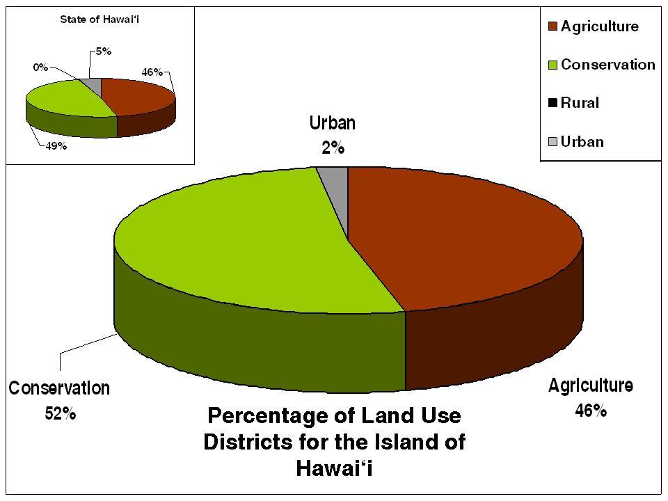
4 Patterns of land use and land cover on the Big Island also approximate statewide configurations. Scrub/shrub, evergreen forest, grassland, and bare land cover 97 percent of the island. Cultivated land and high and low intensity development capture small percentages but do reflect conditions statewide. Land use districts on the Island of Hawaiÿi have similar distributions for the averages noted for all the high islands. Conservation and agriculture are the predominant categories while urban environs are a small fraction. xlvi
5 xlvii

6 Stewardship for Big Island rests mostly with private owners (about half the land) and with the State of Hawaiÿi (about one third). Military, federal, and Hawaiian Homestead lands approximate the percentages recorded statewide. References: Juvik, S. P. & J. O. Juvik, Atlas of Hawaiÿi, 3 rd edition, University of Hawaii Press, Honolulu. 333 pp. Parham, J. E Spatial models of Hawaiian streams and stream fish habitats. Ph.D. Dissertation, Louisiana State University, 149 pp. xlviii
Wailua River, Kauaÿi. Wailua River, Kauaÿi WATERSHED FEATURES
 Wailua River, Kauaÿi DAR Watershed Code: 22008 Wailua River, Kauaÿi WATERSHED FEATURES Wailua River watershed occurs on the island of Kauaÿi. The Hawaiian meaning of the name is two waters. The area of
3.9 FROM ISLANDS TO ATOLLS
 3.9 1 3.9 FROM ISLANDS TO ATOLLS OBJECTIVES The students Listen to a description of the formation of volcanic islands, fringing reefs, barrier reefs, and atolls. Observe and participate in a simulation
STREAM SURVEY File form No..
 scanned for KRIS THE RESOURCES AGENCY OF CALIFORNIA California Department of Fish and Game STREAM SURVEY File form No.. Date: September 4, 1969. NAME: North Fork Schooner Gulch Creek COUNTY: Mendocino.
Coastal management has lagged behind the growth in population leading to problems with pollution
 Fifty percent of the population of the industrialized world lives within 100 km of a coast. Coastal management has lagged behind the growth in population leading to problems with pollution and natural
O opu Life Cycle NATIVE ANIMALS
 Concepts Life cycle Physical transformation HCPS III Benchmarks SC 1.2.2 SC 1.5.2 Duration 1 hour NATIVE ANIMALS IN AN AHUPUA A Source Material PRISM Ohia Project Vocabulary Life cycle Hatch Larvae Forage
Canada s Natural Systems. Canadian Geography 1202
 Canada s Natural Systems Canadian Geography 1202 Canada s Natural Systems Natural System: A system found in nature Here are the four natural systems that we will explore in the next few weeks 1. Canada
Florida Seagrass Integrated Mapping and Monitoring Program
 Florida Seagrass Integrated Mapping and Monitoring Program - 2004 The following document is composed of excerpts taken from the 2011 publication, Seagrass Integrated Mapping and Monitoring for the State
- terminology. Further Reading: Chapter 07 of the text book. Outline. - characteristics of ENSO. -impacts
 (1 of 14) Further Reading: Chapter 07 of the text book Outline - terminology - characteristics of ENSO -impacts (2 of 14) Today: Introduction We want to look at another source of variability in the atmosphere
The Setting - Climatology of the Hawaiian Archipelago. Link to Video of Maui Waves
 The Setting - Climatology of the Hawaiian Archipelago Link to Video of Maui Waves What caused this week s weather? What caused this weekend s weather? Today s Objective: Provide overview and description
ADOPT-A-STREAM WATERSHED APPROACH COMMUNITY-BASED STEWARDSHIP. Nova Scotia Salmon Association March 2005
 ADOPT-A-STREAM A WATERSHED APPROACH TO COMMUNITY-BASED STEWARDSHIP Nova Scotia Salmon Association March 2005 This manual is a revised and updated version of the 1994 Adopt-a-Stream manual that was prepared
Tropical Pacific Ocean remains on track for El Niño in 2014
 1 of 10 3/06/2014 3:33 PM ENSO Wrap-Up Current state of the Pacific and Indian Ocean Tropical Pacific Ocean remains on track for El Niño in 2014 Issued on Tuesday 3 June 2014 Product Code IDCKGEWWOO The
Study Update Tailrace Slough Use by Anadromous Salmonids
 Study Update Tailrace Slough Use by Anadromous Salmonids Goals and Objectives Identify what anadromous salmonids use the tailrace slough by: Life Stage (Juvenile, migrating and spawning adults) Timing
and the Link between Oceans, Atmosphere, and Weather
 Geography Worksheet Instructions Using a map, atlas, or any other materials your teacher suggests, label the following on the blank map provided. 1. Label East, West, North, and South. 2. Label the following
STUDY PERFORMANCE REPORT
 STUDY PERFORMANCE REPORT State: Michigan Project No.: F-80-R-4 Study No.: 702 Title: Effects of sediment traps on Michigan river channels Period Covered: October 1, 2002 to September 30, 2003 Study Objectives:
RIVER CONONISH INVERTEBRATE SURVEY Dr Kjersti Birkeland
 RIVER CONONISH INVERTEBRATE SURVEY 26 Dr Kjersti Birkeland Background The Cononish, the upper reaches of the River Dochart, should be very important for spring salmon but surveys by the Tay District Salmon
Notepack 41. Aim: What factors determine the climate of a certain area? Do Now: What is the difference between weather and climate?
 Notepack 41 Aim: What factors determine the climate of a certain area? Do Now: What is the difference between weather and climate? WEATHER VS. CLIMATE Weather atmospheric conditions at a certain location
WFC 50 California s Wild Vertebrates Jan. 11, Inland Waters (Lakes and Streams) Lisa Thompson
 Lisa Thompson") Inland Waters: Lakes and Streams WFC 50 11 January 2011 Lisa Thompson Fisheries Extension Specialist Wildlife, Fish, & Conservation Biology Department University of California, Davis Take home messages
Inland Waters: Lakes and Streams WFC 50 11 January 2011 Lisa Thompson Fisheries Extension Specialist Wildlife, Fish, & Conservation Biology Department University of California, Davis Take home messages
Aquatic Biological Assessment. Lassen 15 Restoration Project. Modoc National Forest Warner Mountain Ranger District
 Aquatic Biological Assessment Lassen 15 Restoration Project Modoc National Forest Warner Mountain Ranger District Prepared By:_/s/ Marty Yamagiwa Date: December 10, 2015 Marty Yamagiwa, Natural Resources
Searsville Dam Removal
 Searsville Dam Removal A unique opportunity for all Presented by the Beyond Searsville Dam Coalition San Francisquito Creek flows into the San Francisco Bay near the Palo Alto Airport and Golf Course seen
Your web browser (Safari 7) is out of date. For more security, comfort and the best experience on this site: Update your browser Ignore
 is out of date. For more security, comfort and the best experience on this site: Update your browser Ignore") Your web browser (Safari 7) is out of date. For more security, comfort and the best experience on this site: Update your browser Ignore L A NIÑA El Niño-Southern Oscillation (ENSO) For the complete encyclopedic
Your web browser (Safari 7) is out of date. For more security, comfort and the best experience on this site: Update your browser Ignore L A NIÑA El Niño-Southern Oscillation (ENSO) For the complete encyclopedic
Land Use Change on Non-Federal Land in Oregon and Washington
 Land Use Change on Non-Federal Land in Oregon and Washington 1974-2014 Presented at: Forest Inventory and Analysis Client Meeting Mt. Hood Community College, October 11, 2017 Background The Development
Physical Geography. Physical Geography III of the United States and Canada. Formation of Great Lakes. Climates of North America. Definitions 2/21/2013
 Physical Geography III of the United States and Canada Ancient Glacial Lakes As the Ice Age ended, areas of North America beyond the terminal moraine were flooded with melt water Prof Anthony Grande AFG
Exit Ticket: Coriolis Effect
 Exit Ticket: Coriolis Effect 1. How does the Coriolis Effect influence the path of projectiles or wind traveling through the atmosphere? Causes them to curve 2. In which direction does the Coriolis Effect
Alberta Conservation Association 2017/18 Project Summary Report
 Alberta Conservation Association 2017/18 Project Summary Report Project Name: Abundance, Distribution, Spawning, and Thermal Habitat of Westslope Cutthroat Trout and Bull Trout in the Stimson Creek Watershed
Oregon Coast Coastal Cutthroat Trout
 Oregon Coast Coastal Cutthroat Trout Species Management Unit Description The Oregon Coast Coastal Cutthroat Trout Species Management Unit (SMU) includes all populations of cutthroat trout inhabiting ocean
Bell Work. Compare and contrast warm fronts and cold fronts. What type of weather is associated with a high pressure and low pressure systems?
 Daily Routine Sit in your appropriate seat quietly Have all necessary materials out All back packs on the floor All cell phones on silent and away in backpacks All music devices off and headphones out
In Activity 36, Storing Waste, you evaluated Yucca Mountain,
 49 Comparing Site Risk TA L K I N G I T O V E R In Activity 36, Storing Waste, you evaluated Yucca Mountain, Nevada as a site for storing nuclear waste. The U.S. Congress considered several other sites
Multi-Scaled Socio-Ecology of the Everglades FCE III Conceptual Framework
 FRESH WATER SUPPLY 1 Multi-Scaled Socio-Ecology of the Everglades FCE III Conceptual Framework Global Climate Change Regional Climate Modulation 2 B O Carbon Cycle P T Organic Matter EXTERNAL DRIVERS LOCAL
8/29/20098 SAHRA - Watershed Visualization
 Module 3 Narration Southwestern Water Cycle 001.wav 26 sec 002.wav 10 sec 003 wav 17 sec Water on Earth is constantly on the move. Water continually circulates between the surface of Earth and the atmosphere
OCEANS. Main Ideas. Lesson 2: Ocean Currents Ocean Currents help distribute heat around Earth.
 Oceans Chapter 10 OCEANS Main Ideas Lesson 2: Ocean Currents Ocean Currents help distribute heat around Earth. Lesson 3: The Ocean Shore The shore is shaped by the movement of water and sand. OCEANS SO
Cambridge International Examinations Cambridge Ordinary Level
 Cambridge International Examinations Cambridge Ordinary Level *3365325931* ENVIRONMENTAL MANAGEMENT 5014/21 Paper 2 May/June 2018 1 hour 30 minutes Candidates answer on the Question Paper. No Additional
Applied Earth Science Climate Exam Practice Questions Page 1
 Name: 1. Which combination of climate factors generally results in the coldest temperatures? A) low elevation and low latitude B) low elevation and high latitude C) high elevation and low latitude D) high
Pacific Climate Variability
 Pacific Climate Variability Pacific Islands Climate Education Partnership You may have heard the term climate variability. What does the term climate variability mean? What are the causes and effects of
Southern Oregon Coastal Cutthroat Trout
 Species Management Unit Description Southern Oregon Coastal Cutthroat Trout The Southern Oregon Coastal Cutthroat Trout SMU includes all populations of cutthroat trout inhabiting ocean tributary streams
Corps Plays Vital Role in Protecting Pacific Reefs
 Public Affairs Office Contact: Joe Bonfiglio Honolulu Engineer District or Sarah H. Cox U.S. Army Corps of Engineers Telephone (808) 438-9862 Fort Shafter, Hawaii 96858-5440 FOR IMMEDIATE RELEASE May 17,
Chapter 12: Coasts (after a brief review of Tides)
") Chapter 12: Coasts (after a brief review of Tides) 1 Questions from previous classes: What happens when a wave meets a current? wave = people walking current = bus If wave goes with the current, the wave
Chapter 12: Coasts (after a brief review of Tides) 1 Questions from previous classes: What happens when a wave meets a current? wave = people walking current = bus If wave goes with the current, the wave
Geology of the Hawaiian Islands
 Geology of the Hawaiian Islands Class 24 8 April 2004 Any Questions? Rise and fall of sea level and its effect on Hawai`i Sea level Has fluctuated up and down many times in the geologic past Evidence?
EXTENT OF OBSERVATION
 scanned for KRIS THE RESOURCES AGENCY OF CALIFORNIA Department of Fish and Game STREAM SURVEY Date: May 25 and 31, 1977. NAME: Unnamed Stream (Tributary to Sonoma Creek) COUNTY: Sonoma. STREAM SECTION:
Where Animals and Plants Are Found
 About Animals and Plants What I Need to Know Many different animals and plants live on Earth. The animals and plants live in different places and make up parts of different ecosystems. In an ecosystem,
Winter Drawdown Issues of Concern
 Winter Drawdown Issues of Concern Wetland Connectivity Amphibians Fisheries Winter Drawdown Wetland Connectivity Wetland complex near Osprey Creek is not responsive to lake level Wetland at upper end of
& La Niña Southern Oscillation Index
 El Niño & La Niña Southern Oscillation Index Today: first of the natural changes Lectures 1) El Nino/La Nina: year- decadal changes in climate system 2) Next: Short term natural changes (centuries to millenia)
Section 2: Biodiversity at Risk
 Section 2: Biodiversity at Risk Preview Classroom Catalyst Objectives Biodiversity at Risk Current Extinctions Species Prone to Extinction How Do Humans Cause Extinctions? Habitat Destruction and Fragmentation
Final Report August 2005
 2.0 REGIONAL STUDY AREA 2.1 Regional Setting 2.1.1 Topography The Los Angeles Region is located within the western portion of the Transverse Ranges Geomorphic Province. The San Andreas transform fault
Trip Report: Eagle Creek, Arizona
 Trip Report: Eagle Creek, Arizona 15-17 June 2009 Participants: Abraham Karam, Brian Kesner, and Mike Childs Native Fish Lab Marsh & Associates, LLC 5016 South Ash Avenue Suite 108 Tempe, Arizona 85282
STUDY GUIDE. Physical Features. The Land. Chapter 23, Section 1. Landforms. Rivers. Natural Resources. Terms to Know DRAWING FROM EXPERIENCE
 For use with textbook pages 569 574. The Land Terms to Know subcontinent A landmass that is large and distinct but joined to a continent (page 569) alluvial plain An area of fertile soil deposited by river
Global Circulations. GEOG/ENST 2331 Lecture 15 Ahrens: Chapter 10
 Global Circulations GEOG/ENST 2331 Lecture 15 Ahrens: Chapter 10 Last lecture Microscale (turbulence) Mesoscale (land/sea breeze) Synoptic scale (monsoon) Global scale (3 cell circulation) Three Cell Model
 ROV Transects of Deep Sea Coral Communities Habitat Type, Species Abundance and Diversity The teacher may choose to explore species abundance and diversity in deep sea coral communities in several different
Unit 11 Lesson 2 How Does Ocean Water Move? Copyright Houghton Mifflin Harcourt Publishing Company
 Unit 11 Lesson 2 How Does Ocean Water Move? Catch a Wave A wave is the up-and-down movement of surface water. Catch a Wave Catch a Wave (wave effects) Surface waves are caused by wind pushing against
Kalihiwai Region of Kauai
 Kalihiwai Region of Kauai Our Second Home overlooking the Ocean Jean and I have spent many months living in Kauai over the past few years, and we have learned a lot about this most distant outpost of America.
Chapter- 9. Multiple Choice Questions
 Chapter- 9 Multiple Choice Questions 1. The low-latitude climates: a. are located along the equator b. are located between the tropics of cancer and capricorn c. do not include the ITCZ d. are restricted
Minnesota Department of Natural Resources Division of Fish and Wildlife Section of Fisheries. Fairhaven Creek 2000
 Minnesota F-29-R(P)-17 Area 340 Study 3 April 2001 Minnesota Department of Natural Resources Division of Fish and Wildlife Section of Fisheries Stream Survey Report Fairhaven Creek 2000 By Eric R. Altena
ECRR and ARRN Technical Exchange Meeting / ARRN forum 2014 (29 Oct in Vienna, Austria)
") Study on ecological flow of Nanxi River (China) based on ecological conservation objective China Institute of Water Resources and Hydropower Research Beijing Runheng EEI CO., LTD October 29, 214 Overview
Study on ecological flow of Nanxi River (China) based on ecological conservation objective China Institute of Water Resources and Hydropower Research Beijing Runheng EEI CO., LTD October 29, 214 Overview
Climate Change Adaptation and Stream Restoration. Jack Williams;
 Climate Change Adaptation and Stream Restoration Jack Williams; jwilliams@tu.org 1 Goals for this presentation Develop strategies for adapting streams to climate impacts by Thinking like a watershed Understanding
Abundance of Steelhead and Coho Salmon in the Lagunitas Creek Drainage, Marin County, California
 scanned for KRIS Abundance of Steelhead and Coho Salmon in the Lagunitas Creek Drainage, Marin County, California Prepared for: Marin Municipal Water District 220 Nellen Drive Corte Madera, California
STUDY GUIDE. The Land. Physical Geography of Europe. Chapter 11, Section 1. Terms to Know DRAWING FROM EXPERIENCE ORGANIZING YOUR THOUGHTS
 For use with textbook pages 271 276. The Land Terms to Know dikes Large banks of earth and stone that hold back water (page 272) polder Drained area of land (page 272) glaciation The process in which glaciers
MT - GEOGRAPHY - (73) - SEMI PRELIM - II : PAPER - 6
 - SEMI PRELIM - II : PAPER - 6") 208 00 MT MT - GEOGRAPHY - (7) - SEMI PRELIM - II : PAPER - 6 Time : 2 Hours (Model Answer Paper) Max. Marks : 0 A.. Fill in the blank choosing the correct alternative : (a) The Barren Island is the only
208 00 MT MT - GEOGRAPHY - (7) - SEMI PRELIM - II : PAPER - 6 Time : 2 Hours (Model Answer Paper) Max. Marks : 0 A.. Fill in the blank choosing the correct alternative : (a) The Barren Island is the only
THE RESOURCES AGENCY OF CALIFORNIA Department of Fish and Game STREAM SURVEY
 File form No.. Date: 4/1/73. NAME: Maacama Creek COUNTY: Sonoma. STREAM SECTION: FROM: Maacama Creek Ranch TO: Chalk Hill Rd. Bridge LENGTH: 1.5 mi.. Bridge OTHER NAMES: Weather - Clear & Sunny RIVER SYSTEM:
Warm-up # 7 A day 5/17 - B day 5/18 UPDATE YOUR TABLE OF CONTENTS
 Warm-up # 7 A day 5/17 - B day 5/18 UPDATE YOUR TABLE OF CONTENTS Question: List all examples of surface water on Earth. Answer: Rivers and streams, lakes and reservoirs, (ponds) wetlands, estuaries and
Texas Water Resources Institute
 Texas Water Resources Institute November/December 1982 Volume 8 No. 6 A Precise Environment By Lou Ellen Ruesink, Editor, Texas Water Resources Aquarium enthusiasts know just how particular fish are about
Stony Creek Creel Census
 Stony Creek Creel Census conducted for Division of Fisheries Illinois Department of Conservation 600 North Grand Ave. West Springfield, IL 62706 by R. Weldon Larimore, Principal Investigator Jack A. Swanson,
Figure 26. Map of ocean related share of GDP in counties of the Gulf of Mexico coast region in (Data Source: National Ocean Economics Program.
 Figure 22. Map of ocean related share of GDP in counties of the North and Middle Atlantic coastal regions in 2009. This map shows the share of ocean related GDP (value added economic activity) in 2009
Context Most US West Coast open coast estuaries have: INTERTIDAL AQUACULTURE AS HABITAT IN PACIFIC NORTHWEST COASTAL ESTUARIES: CONSIDERING SCALE
 INTERTIDAL AQUACULTURE AS HABITAT IN PACIFIC NORTHWEST COASTAL ESTUARIES: CONSIDERING SCALE Brett Dumbauld USDA Agricultural Research Service Context Most US West Coast open coast estuaries have: Broad
Sebec Lake Fisheries Management Plan 2012
 Sebec Lake Fisheries Management Plan 2012 Sebec Lake is a 6,800-acre oligotrophic lake located in northwestern Maine. It has popular fisheries for landlocked salmon, lake trout, and smallmouth bass. Other
The Movement of Ocean Water. Currents
 The Movement of Ocean Water Currents Ocean Current movement of ocean water that follows a regular pattern influenced by: weather Earth s rotation position of continents Surface current horizontal movement
Minnesota Department of Natural Resources Division of Fish and Wildlife Section of Fisheries. Stream Survey Report. Three Mile Creek 2011
 Minnesota Department of Natural Resources Division of Fish and Wildlife Section of Fisheries Stream Survey Report Three Mile Creek 2011 By Joseph D. Stewig Montrose Area Fisheries Office TABLE OF CONTENTS
Lecture Outlines PowerPoint. Chapter 18 Earth Science 11e Tarbuck/Lutgens
 Lecture Outlines PowerPoint Chapter 18 Earth Science 11e Tarbuck/Lutgens 2006 Pearson Prentice Hall This work is protected by United States copyright laws and is provided solely for the use of instructors
Fraser River. FISH SURVEY AND MANAGEMENT INFORMATION Jon Ewert - Aquatic Biologist (Hot Sulphur Springs)
") Fraser River FISH SURVEY AND MANAGEMENT INFORMATION Jon Ewert - Aquatic Biologist (Hot Sulphur Springs) General Information: The Fraser River is a highly diverse river offering many transitions in habitat
Fraser River FISH SURVEY AND MANAGEMENT INFORMATION Jon Ewert - Aquatic Biologist (Hot Sulphur Springs) General Information: The Fraser River is a highly diverse river offering many transitions in habitat
Identifying Areas with Potential to Contain High Value Fish Habitat (HVFH) June 2007
 June 2007") Identifying Areas with Potential to Contain High Value Fish Habitat (HVFH) June 2007 1 High Value Fish Habitat INTENT: To apply added precautionary protection to those special areas deemed of high value
Identifying Areas with Potential to Contain High Value Fish Habitat (HVFH) June 2007 1 High Value Fish Habitat INTENT: To apply added precautionary protection to those special areas deemed of high value
REGIONAL AND LOCAL VARIATION OF BOTTOM FISH AND INVERTEBRATE POPULATIONS
 M. James Allen and Robert Voglin REGIONAL AND LOCAL VARIATION OF BOTTOM FISH AND INVERTEBRATE POPULATIONS One of the projects included in our recently completed research for the EPA was an assessment of
Endangered Species Endangered Species. For More Quality Materials like these visit montessorihelper.com
 Endangered Species Endangered Species Photo credit: Sebastian Bergmann/Creative Commons Photo credit: Sebastian Bergmann/Creative Commons Giant Panda Giant Panda Their naturally limited niche in Asia's
The Case of the Disappearing Shoreline
 Name The Case of the Disappearing Shoreline Humans change the earth's climate in many ways. One change is the increase of carbon dioxide in the atmosphere. As we burn more fossil fuels, we release more
OCEANOGRAPHY STUDY GUIDE
 OCEANOGRAPHY STUDY GUIDE Chapter 2 Section 1 1. Most abundant salt in ocean. Sodium chloride; NaCl 2. Amount of Earth covered by Water 71% 3. Four oceans: What are they? Atlantic, Pacific, Arctic, Indian
Climate briefing. Wellington region, February Alex Pezza and Mike Thompson Environmental Science Department
 Climate briefing Wellington region, February 2016 Alex Pezza and Mike Thompson Environmental Science Department For more information, contact the Greater Wellington Regional Council: Wellington PO Box
Regulations. Grabbling season May 1 July 15; only wooden structures allowed.
 Arkabutla Reservoir 219 REEL FACTS Keith Meals, Arthur Dunn, Stanley Turner Fisheries Biologists keithm@wfp.ms.gov, ArthurD@wfp.ms.gov, StanleyT@wfp.ms.gov General Information: Arkabutla Reservoir is one
California Steelhead: Management, Monitoring and Recovery Efforts
 California Steelhead: Management, Monitoring and Recovery Efforts Jonathan Nelson Steelhead Management, Research and Restoration Program Oncorhynchus mykiss irideus California Steelhead - Hot Topics Implementation
Michigan Department of Natural Resources Status of the Fishery Resource Report Page 1
 Michigan Department of Natural Resources 2008-59 Status of the Fishery Resource Report Page 1 Bowens Manistee County, (T24N R16W Sec. 11, 12, 13, 14, 15, 24, and 30). Last surveyed 2008 Mark A. Tonello
Minnesota Department of Natural Resources Division of Fish and Wildlife Section of Fisheries. Stream Survey Report. Cold Spring Creek.
 Minnesota F-29-R(P)-24 Area 315 Study 3 March 2015 Minnesota Department of Natural Resources Division of Fish and Wildlife Section of Fisheries Stream Survey Report Cold Spring Creek 2014 Mark Pelham Montrose
Interim Guidance Fish Presence Absence
 Interim Guidance Fish Presence Absence Source: Forest Practices Act Guidance for Division 635 of the forest practices act dealing with stream classification when no fish surveys have been done (referenced
MINNESOTA DEPARTMENT OF NATURAL RESOURCES DIVISION OF FISHERIES AND WILDLIFE. Gamefish Assessment Report
 Minnesota DNR F-29-R(P) Area F312 February 1, 2013 MINNESOTA DEPARTMENT OF NATURAL RESOURCES DIVISION OF FISHERIES AND WILDLIFE Gamefish Assessment Report Spring Gamefish Assessment on the Mississippi
Catlow Valley Redband Trout
 Catlow Valley Redband Trout Existing Populations The Catlow Valley Redband Trout SMU is comprised of five populations (Table 1). Three exist in Home, Threemile, and Skull creeks, located on the east side
FISHERIES BLUE MOUNTAINS ADAPTATION PARTNERSHIP
 FISHERIES A warming climate, by itself, substantially affects the hydrology of watersheds in the Blue Mountains. Among the key hydrologic changes projected under all scenarios for the 2040s and beyond
Executive Summary. Map 1. The Santa Clara River watershed with topography.
 Santa Clara River Steelhead Trout: Assessment and Recovery Opportunities December 2005 Prepared By: Matt Stoecker and Elise Kelley, Ph.D. University of California, Santa Barbara Prepared For: The Santa
Project Webpage:
 Project Webpage: http://nature.ly/marinesatlanticbightera Coastal Data and Full Metadata: http://easterndivision.s3.amazonaws.com/marine/sab MA/SABMACoastalEcosystems.zip Coastal Chapter: http://easterndivision.s3.amazonaws.com/marine/sab
5B. Management of invasive species in the Cosumnes and Mokelumne River Basins
 5B. Management of invasive species in the Cosumnes and Mokelumne River Basins Cosumnes River The Cosumnes River basin has a number of distinct habitat types that require different management strategies
Outline. 1. Overview 2. Population 3. Flooding 4. Land Use 5. References. Overview
 Outline 1. Overview 2. Population 3. Flooding 4. Land Use 5. References Overview The two main rivers in the Cannon River watershed are the Cannon and Straight Rivers. The Cannon River originates in Shields
Preferential habitat and spatial distribution of 3. species of sicydiine gobies (Genus Sicydium) based. on substrate and flow rate within the
 based. on substrate and flow rate within the") Preferential habitat and spatial distribution of 3 species of sicydiine gobies (Genus Sicydium) based on substrate and flow rate within the Checkhall River By: Chase Corrington Texas A&M University Department
Preferential habitat and spatial distribution of 3 species of sicydiine gobies (Genus Sicydium) based on substrate and flow rate within the Checkhall River By: Chase Corrington Texas A&M University Department
Section 6. The Surface Circulation of the Ocean. What Do You See? Think About It. Investigate. Learning Outcomes
 Chapter 5 Winds, Oceans, Weather, and Climate Section 6 The Surface Circulation of the Ocean What Do You See? Learning Outcomes In this section, you will Understand the general paths of surface ocean currents.
Lye Brook Amphibian Monitoring. Update. For the Vermont Monitoring Cooperative
 Lye Brook Amphibian Monitoring Update 2010 (Covering 1995-2009) For the Vermont Monitoring Cooperative Erin Talmage and James S. Andrews Amphibian Monitoring in the Lye Brook Wilderness Region of the Green
Rivers And Streams (The Living Earth)
") Rivers And Streams (The Living Earth) If you are searched for the ebook Rivers and Streams (The Living Earth) in pdf format, then you have come on to the correct website. We present utter edition of this
Rivers And Streams (The Living Earth) If you are searched for the ebook Rivers and Streams (The Living Earth) in pdf format, then you have come on to the correct website. We present utter edition of this
Water Budget I: Precipitation Inputs
 Water Budget I: Precipitation Inputs Forest Cover Forests and Rainfall Forests won t grow where P < 15 / yr Forest type depends strongly on rainfall quantity, type (snow, rain) and timing (summer, winter)
Lake Chelan Kokanee Spawning Ground Surveys 2012 Final Report
 Lake Chelan Kokanee Spawning Ground Surveys 2012 Final Report Spawning kokanee (Oncorhynchus nerka) in Company Creek Chelan County PUD, 2005. (Photo by Brad Buchsieb) Prepared by: Barry G. Keesee And Lance
Managing Chesapeake Bay s Land Use, Fish Habitat, and Fisheries: Studies. Jim Uphoff & Margaret McGinty, Fisheries Service
 Managing Chesapeake Bay s Land Use, Fish Habitat, and Fisheries: Positive Image and or Negative Graphic Case Studies Jim Uphoff & Margaret McGinty, Fisheries Service Maryland Fisheries Service has been
Mill Creek/Rose Valley Watershed General Information Presented by Dr. Mel Zimmerman Lycoming College CWI
 Mill Creek/Rose Valley Watershed General Information Watershed Concerns Rose Valley Lake Areas of Interest Biodiversity of Interest in Rose Valley Lake Rose Valley Lake Bird Area Fishes of Rose Valley
Maryland Chapter Trout Unlimited Brook Trout Conservation Effort
 Maryland Chapter Trout Unlimited Brook Trout Conservation Effort Photo by Matt Kline Portfolio of Recent Work MDTU Brook Trout Conservation Coordinator: Scott C. Scarfone, ASLA sscarfone@oasisdesigngroup.com
SCI-2 MMS Ecosystems and Review Quiz Exam not valid for Paper Pencil Test Sessions
 SCI-2 MMS Ecosystems and Review Quiz Exam not valid for Paper Pencil Test Sessions [Exam ID:23VRZ2 1 Which of the following does NOT describe a rain forest? A Snow B Rain C Wet grounds D Hot temperatures
1.6 HIGH RESOLUTION SIMULATIONS OF THE ISLAND-INDUCED CIRCULATIONS FOR THE ISLAND OF HAWAII DURING HaRP. Yang Yang and Yi-Leng Chen*
 1.6 HIGH RESOLUTION SIMULATIONS OF THE ISLAND-INDUCED CIRCULATIONS FOR THE ISLAND OF HAWAII DURING HaRP Yang Yang and Yi-Leng Chen* Department of Meteorology University of Hawaii at Manoa Honolulu, Hawaii
Amendment to a Biological Assessment/Evaluation completed for the Coon Creek Land Disposal completed December Grand Valley Ranger District
 Amendment to a Biological Assessment/Evaluation completed for the Coon Creek Land Disposal completed December 2007 Grand Valley Ranger District Grand Mesa, Uncompahgre, Gunnison National Forests Prepared
Weather of the Promised Land
 Biblical Geography Basics NT110 LESSON 10 of 10 Jack Beck, Ph.D. Experience: Author and faculty member at Jerusalem University College in Israel Introduction There s geography in my Bible. Remember, we
The Calawah River System
 The Calawah River System The Calawah River is the largest tributary of the Bogachiel River and is formed by the confluence of the north and south forks of the Calawah. The two forks of the Calawah, CALAWAH
6TH PELLETIER BROOK LAKE T15 R9, Aroostook Co. U.S.G.S. Gardner Pond, Maine (7 1/2 )
") 6TH PELLETIER BROOK LAKE T15 R9, Aroostook Co. U.S.G.S. Gardner Pond, Maine (7 1/2 ) Fishes Brook trout Minnows Blacknose dace Pearl dace Physical Characteristics Area - 27 acres Average depth - 2 feet
6TH PELLETIER BROOK LAKE T15 R9, Aroostook Co. U.S.G.S. Gardner Pond, Maine (7 1/2 ) Fishes Brook trout Minnows Blacknose dace Pearl dace Physical Characteristics Area - 27 acres Average depth - 2 feet