The Masterplan Coastal Safety: a wave of opportunities
|
|
|
- Kerrie Cole
- 5 years ago
- Views:
Transcription


1 The Masterplan Coastal Safety: a wave of opportunities In depth coastal research and state of the art maritime technology SPINCAM WEEK FLANDERS: OSTEND EVENT FEBRUARY 16-18th 2016 elias.vanquickelborne@mow.vlaanderen.be
2 Content Masterplan Coastal safety Underpinned by wide and detailed academic/scientific research & study Implementation through intensive monitoring strategies State of the art cases such as: - Nourishment program - Flood barrier - Stilling wave basin - Seadike reflecting wave concept - Nature expansion

3 Masterplan Coastal Safety More than 85% of the polders beneath +5m TAW (average storm)

4 Masterplan Coastal Safety Flood map of a 1000 year storm event
5 Masterplan Coastal Safety 1/3th of the Belgian coastline is not sufficiently protected against severe storm events. The Integrated Master Plan for Coastal Safety has been set up which forms the basis for the development of the seafront along the Belgian coast in the nearby and distant future (up till 2050) with safety against flooding as its main objective. estimated sea level rise in 2050: 30cm Proposed measures were approved on June 10th 2011 by the Flemish government Estimated cost: 300M
6 Scientific research & study First safety check (2007 till 2011) Norm: No fatalities due to a 1000 year storm Limited overtopping across the safety line: 1l/m/s No breaching of dunes and dikes No dune erosion that damages residential properties

7 Scientific research & study Outcome FSC
8 Scientific research & study Second safety check (ongoing) An update of the safety assessment methodology and hydraulic boundary conditions was needed New calculation methods for: - Beach and dune erosion: XBeach 2D - Determination of boundary condition at the toe of the dike: SWASH 2D - Calculation of wave overtopping: SWASH 1D + overtopping formulas

9 Intensive monitoring strategies Topography (LiDAR) & Bathymetry Hydrodynamic monitoring Ecological monitoring eg. pilot foreshore nourishment Mariakerke - Argus system: camera morphological changes - Intensified bathy, DTM, current and wave monitoring - Ecological monitoring (model input profile / grain size; output cf. species)

10 Nourishment program
11 Nourishment program

12 Nourishment program
13 Nourishment program Involved communities : De Panne Koksijde Westende Middelkerke Raversijde Mariakerke Oostende De Haan Blankenberge Knokke-Heist Up to now: 6,5 million m³ of wich over 4 million m³ sept sept Foreshore nourishments : decrease maintenance 2nd safety assessment in progress

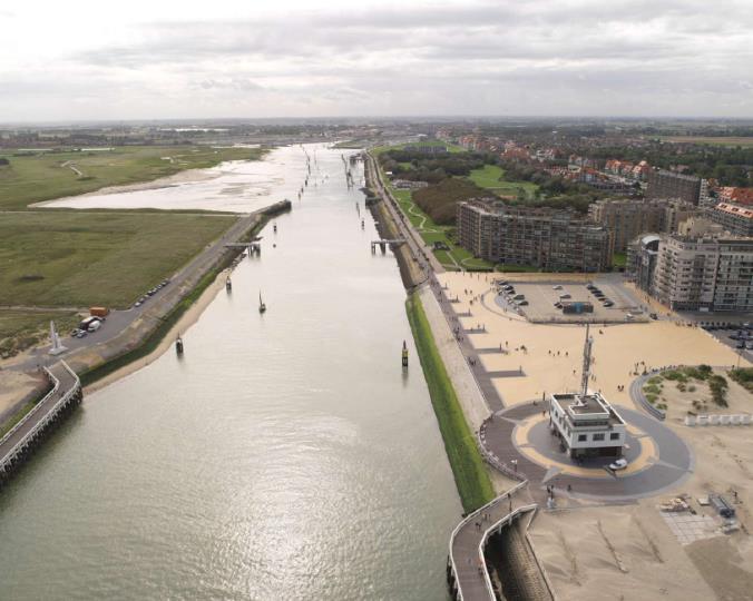
14 Storm surge barrier Positioning: Nieuwpoort
15 Storm surge barrier Preconditions - Achieve a movable barrier - Passage width 38 m - Unlimited vertical clearance - Protection against a year storm (in 2100) Water level: + 7,64mTAW - Wave height Hs: 2,20m - Offer resistance to a + 8m storm (in 2100) Water level: + 8,64m TAW - Wave height Hs: 2,50m

16 Storm surge barrier Draft showing:

17 Storm surge barrier

18 Stilling wave basin

19 Seadike reflecting wave concept New sea wall Wenduine
20 Seadike reflecting wave concept Principle
 - Failure probability design of 1 % Physical scale models: optimal geometry of wave return walls and measure forces on wave return")
21 Seadike reflecting wave concept Design: - Design storm: 1000 year annual recurrence interval storm: target value of discharge q = 1 l/s/m - During +8,0 m Superstorm: no breaching tolerable (q < 100 l/s/m) - Failure probability design of 1 % Physical scale models: optimal geometry of wave return walls and measure forces on wave return walls


22 Seadike reflecting wave concept Realisation seaside wave return wall with parapet

23 Seadike reflecting wave concept New sea wall Wenduine - detail


24 Zwin nature expansion Zwin Nature reserve


25 Zwin nature expansion Zwin Nature reserve
26 Zwin nature expansion Objective Combat silting up of the Zwin Add additional areas to the nature reserve (213ha) Limiting the risk of flooding for the hinterland (secondary objective) A cross-border expansion of 120 hectares 10ha on Dutch territory Total of 333ha Managed by MDK (project lead), ANB, VMM and the Province of Zeeland

27 Zwin nature expansion Actions Nature restoration in the existing is Zwin plain: typical estuary plants and animals by ensuring that the seawater is able to flow in and out of the Zwin more easily Gully excavated Controllable dam Separate islands for breeding birds

28 Zwin nature expansion Actions Dike: The new dike will be able to withstand a year storm. Length +/-3,9 km, Crest +/-7,5m NAP Cycling and hiking trail, viewing points & footbridge Improved water management in order to prevent problems of salinisation of the ground and surface water, flood damage and drought in the surrounding polder Salt/Fresh ditches & Fish-friendly pumping station
29 Zwin nature expansion Planning Extensive preliminary studies and procedures (i.e. expropriation of farmers/camping site and a zoning change FL + NL Appeal rejected 11/09/2015 (FL) & 23/09/2015 (NL) Urban planning permit (granted 09/06/2015) Construction file (opening tenders 18/09/2015) App. 13M Euro Start works (March 15th 2016) Excecution period: 3y Current dike can only be excavated when new dike is finished and verified

30 Het Zwin in verandering

31
32

33
34
35
EXISTING AND PLANNED STRATEGIES AND ACTIONS CONNECTED WITH COASTAL PROTECTION IN ASPECT OF PREDICTED SEA LEVEL RISE
 EXISTING AND PLANNED STRATEGIES AND ACTIONS CONNECTED WITH COASTAL PROTECTION IN ASPECT OF PREDICTED SEA LEVEL RISE Andrzej Cieślak Long term coastal protection strategy In 2000 a new 1 Polish long term
INTEGRATED DESIGN OF COASTAL PROTECTION WORKS FOR WENDUINE, BELGIUM
 INTEGRATED DESIGN OF COASTAL PROTECTION WORKS FOR WENDUINE, BELGIUM William Veale 1,2, Tomohiro Suzuki 1,2,3, Toon Verwaest 2, Koen Trouw 4,5 and Tina Mertens 5 Wave overtopping tests were performed with
The Sand Motor. Looking back at 2,5 years of building with nature. Anne-Marie Svoboda Rijkswaterstaat Sea and Delta
 The Sand Motor Looking back at 2,5 years of building with nature Anne-Marie Svoboda Sea and Delta Overview RWS and USACE Coastal nourishment strategy Coastal vision The Sand Motor: Design How does it work?
SPH applied to coastal engineering problems
 2 nd Iberian Workshop Ourense, 3 rd and 4 th December 2015 SPH applied to coastal engineering problems (validating the SPH concept) ALTOMARE, CRESPO, DOMINGUEZ, SUZUKI http://www.flandershydraulicsresearch.be/
A NUMERICAL STUDY ON THE EFFECT OF BEACH NOURISHMENT ON WAVE OVERTOPPING IN SHALLOW FORESHORES
 A NUMERICAL STUDY ON THE EFFECT OF BEACH NOURISHMENT ON WAVE OVERTOPPING IN SHALLOW FORESHORES Tomohiro Suzuki,,, Toon Verwaest, William Veale,, Koen Trouw, and Marcel Zijlema In this paper, the effect
The History of Coastal Flood Hazard Assessments in the Great Lakes
 The History of Coastal Flood Hazard Assessments in the Great Lakes Brian A. Caufield, P.E., CFM June 23, 2016 2 The Great Lakes Some Statistics Courtesy of Great Lakes Information Network One-fifth of
THE EFFECT OF VARIOUS DIKE REINFORCEMENT ALTERNATIVES ON THE FLOOD SAFETY ASPECTS OF THE DELTADIKE CONCEPT
 THE EFFECT OF VARIOUS DIKE REINFORCEMENT ALTERNATIVES ON THE FLOOD SAFETY ASPECTS OF THE DELTADIKE CONCEPT Preliminary Final Report Master Thesis Written by Simon den Hengst Delft, 08 December 2012 Recent
Cross-shore sediment transports on a cut profile for large scale land reclamations
 Cross-shore sediment transports on a cut profile for large scale land reclamations Martijn Onderwater 1 Dano Roelvink Jan van de Graaff 3 Abstract When building a large scale land reclamation, the safest
City of Del Mar Local Coastal Plan (LCP) Amendment for Sea Level Rise and Coastal Flooding
 Amendment for Sea Level Rise and Coastal Flooding") City of Del Mar Local Coastal Plan (LCP) Amendment for Sea Level Rise and Coastal Flooding 6/22/17 Presentation to Sea Level Rise Stakeholder- Technical Advisory Committee (STAC) Nick Garrity, P.E. Lindsey
City of Del Mar Local Coastal Plan (LCP) Amendment for Sea Level Rise and Coastal Flooding 6/22/17 Presentation to Sea Level Rise Stakeholder- Technical Advisory Committee (STAC) Nick Garrity, P.E. Lindsey
Belgium - Majestic Cycling Along the North Sea Coast Bicycle Tour (2018) Individual Self-guided 7 days / 6 nights
 Individual Self-guided 7 days / 6 nights") Belgium - Majestic Cycling Along the North Sea Coast Bicycle Tour (2018) Individual Self-guided 7 days / 6 nights Culture, elegance and relaxation: these are the best words to describe this holiday. The
Belgium - Majestic Cycling Along the North Sea Coast Bicycle Tour (2018) Individual Self-guided 7 days / 6 nights Culture, elegance and relaxation: these are the best words to describe this holiday. The
PRESSURE EQUALISATION MODULES FOR ENVIRONMENTALLY FRIENDLY COASTAL PROTECTION
 PRESSURE EQUALISATION MODULES FOR ENVIRONMENTALLY FRIENDLY COASTAL PROTECTION Poul Jakobsen Skagen Innovation Centre, Dronning Alexandrinesvej 7, DK - 999 Skagen, Denmark Abstract Land-based activities
NORTHERN CELL OPTIONS SHORTLIST RECOMMENDATIONS
 OPTIONS SHORTLIST RECOMMENDATIONS Coastal Unit C: Bayview Options recommended for MCDA scoring. Status quo. Planting 3. Renourishment (gravel) 6. Beach-scraping 7. Restore shingle crest. Inundation accommodation
Evaluation of June 9, 2014 Federal Emergency Management Agency Flood Insurance Study for Town of Weymouth, Norfolk, Co, MA
 Evaluation of June 9, 2014 Federal Emergency Management Agency Flood Insurance Study for Town of Weymouth, Norfolk, Co, MA Prepared For: Woodard & Curran 95 Cedar Street, Suite 100 Providence, RI 02903
4/20/17. #30 - Coastlines - General Principles Coastlines - Overview
 Writing Assignment Due one week from today by 11:59 pm See main class web pages for detailed instructions Essays will be submitted in Illinois Compass (instructions later) Pick one: Earthquakes, tsunamis,
Oil spill drift study for NORTHER By V. Dulière and S. Legrand
 October 2011 Oil spill drift study for NORTHER By V. Dulière and S. Legrand 1. Introduction The risk for navigation accident and therefore also for oil spilled at sea increases with the installation of
CHAPTER 212 THE BEACH REHABILITATION PROJECT AT OSTEND-BELGIUM. ir. R. SIMOEN* ir. H. VERSLYPE** ir. D. VANDENBOSSCHE***
 CHAPTER 212 THE BEACH REHABILITATION PROJECT AT OSTEND-BELGIUM ir. R. SIMOEN* ir. H. VERSLYPE** ir. D. VANDENBOSSCHE*** Abstract Steady erosion has occured on the beaches at Ostend, Belgium, especially
Habitat Development: Habitat Boulders Lawson Pier Foreshore Enhancement
 Habitat Development: Habitat Boulders Improve the existing habitat by stabilising beach sediments. Increase biodiversity by creating new habitats and colonisation opportunities. Loose cobble is unstable;
CHARACTERIZATION OF WAVE IMPACTS ON CURVE FACED STORM RETURN WALLS WITHIN A STILLING WAVE BASIN CONCEPT. , Toon Verwaest 1, Tomohiro Suzuki 1, 3
 CHARACTERIZATION OF WAVE IMPACTS ON CURVE FACED STORM RETURN WALLS WITHIN A STILLING WAVE BASIN CONCEPT Corrado Altomare 1, 2, Toon Verwaest 1, Tomohiro Suzuki 1, 3, Koen Trouw 1, 4 Low lying coastal areas
CHAPTER 134 INTRODUCTION
 CHAPTER 134 NEW JETTIES FOR TUNG-KANG FISHING HARBOR, TAIWAN Chi-Fu Su Manager Engineering Department Taiwan Fisheries Consultants, Inc. Taipei, Taiwan INTRODUCTION Tung-Kang Fishing Harbor, which is about
The construction of Deepwater Navigation Channel (DNC) in the Bystry arm of the Danube Delta has started in The whole project provides the
 in the Bystry arm of the Danube Delta has started in The whole project provides the") Annex 45 Numerical Studies of Waves, Currents and Sediment Transport at the Marine Part of Deepwater Navigation Channel through the Bystry Arm of the Danube Delta and Model Verification based on Laboratory
Annex 45 Numerical Studies of Waves, Currents and Sediment Transport at the Marine Part of Deepwater Navigation Channel through the Bystry Arm of the Danube Delta and Model Verification based on Laboratory
DELAWARE S VULNERABLE COASTAL AREAS. DELAWARE INLAND BAYS and DELAWARE BAY RECONNAISSANCE STUDY
 DELAWARE S VULNERABLE COASTAL AREAS and the DELAWARE INLAND BAYS and DELAWARE BAY RECONNAISSANCE STUDY Kimberly K. McKenna, PG Delaware Dept. of Natural Resources & Environmental Control Division of Watershed
HURRICANE SANDY LIMITED REEVALUATION REPORT UNION BEACH, NEW JERSEY DRAFT ENGINEERING APPENDIX SUB APPENDIX D SBEACH MODELING
 HURRICANE SANDY LIMITED REEVALUATION REPORT UNION BEACH, NEW JERSEY DRAFT ENGINEERING APPENDIX SUB APPENDIX D SBEACH MODELING Rev. 18 Feb 2015 1 SBEACH Modeling 1.0 Introduction Following the methodology
Controlling Coastal erosion
 Controlling Coastal erosion Coastal Erosion Rates in the U.S. Coastal Erosion and Stabilization Economic pressures demanding the stabilization of beaches and coastlines are immense Coastal Erosion and
DESTRUCTIVE WAVE OVERTOPPING TESTS ON FLEMISH DIKES
 DESTRUCTIVE WAVE OVERTOPPING TESTS ON FLEMISH DIKES Gosse Jan Steendam 1, Patrik Peeters 2, Jentsje van der Meer 3, Koen van Doorslaer 4 and Koen Trouw 5 Breaching of dikes induced by wave overtopping
Louisiana CPRA SJB Group, Baton Rouge Coastal Engineering Consultants U.S. Army Corps of Engineers Federal and State PDT Members
 Louisiana CPRA SJB Group, Baton Rouge Coastal Engineering Consultants U.S. Army Corps of Engineers Federal and State PDT Members Project Setting and Background Island Restoration Plans Pre-Screening Analysis
Pathways Interns: Annika O Dea, Ian Conery, Andrea Albright
 1 REMOTE SENSING OF COASTAL MORPHODYNAMICS 237 237 237 217 217 217 2 2 2 8 119 27 252 174.59 255 255 255 163 163 163 131 132 122 239 65 53 11 135 12 112 92 56 62 12 13 12 56 48 13 12 111 Kate Brodie Brittany
Atlantic Coast of Long Island, Jones Inlet to East Rockaway Inlet, Long Beach Island, NY Construction Update
 Atlantic Coast of Long Island, Jones Inlet to East Rockaway Inlet, Long Beach Island, NY Construction Update June 2016 US Army Corps of Engineers Project Purpose Three specific damage mechanisms of coastal
CHAPTER 231 OFFSHORE BREAKWATERS VERSUS BEACH NOURISHMENTS A COMPARISON
 CHAPTER 231 OFFSHORE BREAKWATERS VERSUS BEACH NOURISHMENTS A COMPARISON M. Pluijm 1, J.C. van der Lem 2, A.W. Kraak 3, J.H.W. de Ruig 4 ABSTRACT In the last decades two methods of coastal protection have
MODELING OF CLIMATE CHANGE IMPACTS ON COASTAL STRUCTURES - CONTRIBUTION TO THEIR RE-DESIGN
 Proceedings of the 14 th International Conference on Environmental Science and Technology Rhodes, Greece, 3-5 September 2015 MODELING OF CLIMATE CHANGE IMPACTS ON COASTAL STRUCTURES - CONTRIBUTION TO THEIR
REVETMENTS. Purposes and Operational Constraints. Purposes Erosion control o o. Revetment Design 4/5/2016. CE A676 Coastal Engineering
 REVETMENTS Ijsseldam, the Netherlands Orson P. Smith, PE, Ph.D. Instructor Purposes and Operational Constraints Purposes Erosion control o o Embankment Toe protection for a seawall, retaining wall or other
COST EFFECTIVE STORAGE CAPACITY INCREASE FOR ALUMINA TAILINGS DISPOSAL AREA THROUGH SPILLWAY OPTIMISATION
 COST EFFECTIVE STORAGE CAPACITY INCREASE FOR ALUMINA TAILINGS DISPOSAL AREA THROUGH SPILLWAY OPTIMISATION Abstract Lonie I * Tailings and Dams, GHD Brisbane, QLD, Australia Queensland Alumina Limited operates
BEACH NOURISHMENT COMBINED WITH SIC VERTICAL DRAIN IN MALAYSIA. Claus Brøgger 1 and Poul Jakobsen 2
 BEACH NOURISHMENT COMBINED WITH SIC VERTICAL DRAIN IN MALAYSIA. Claus Brøgger 1 and Poul Jakobsen 2 The present paper presents measurements and results from a three year full scale Pilot Project with the
Artificial Surf Reef on Maasvlakte 2
 Artificial Surf Reef on Maasvlakte 2 Msc. Thesis M.P. Muilwijk Final Version June 2005 Delft University of Technology II Artificial Surf Reef on Maasvlakte 2 Msc. Thesis M.P. Muilwijk Final Version June
SELECTION OF THE PREFERRED MANAGEMENT OPTION FOR STOCKTON BEACH APPLICATION OF 2D COASTAL PROCESSES MODELLING
 SELECTION OF THE PREFERRED MANAGEMENT OPTION FOR STOCKTON BEACH APPLICATION OF 2D COASTAL PROCESSES MODELLING C Allery 1 1 DHI Water and Environment, Sydney, NSW Abstract This paper presents an approach
Shoreline Evolution Due to Oblique Waves in Presence of Submerged Breakwaters. Nima Zakeri (Corresponding Author), Mojtaba Tajziehchi
, Mojtaba Tajziehchi") Shoreline Evolution Due to Oblique Waves in Presence of Submerged Breakwaters Nima Zakeri (Corresponding Author), Mojtaba Tajziehchi Department of Civil Engineering, Faculty of Engineering, University
Shoreline Evolution Due to Oblique Waves in Presence of Submerged Breakwaters Nima Zakeri (Corresponding Author), Mojtaba Tajziehchi Department of Civil Engineering, Faculty of Engineering, University
Reading Material. Inshore oceanography, Anikouchine and Sternberg The World Ocean, Prentice-Hall
 Reading Material Inshore oceanography, Anikouchine and Sternberg The World Ocean, Prentice-Hall BEACH PROCESSES AND COASTAL ENVIRONMENTS COASTAL FEATURES Cross section Map view Terminology for Coastal
Future Condi,ons coastal hazard modeling and mapping
 Future Condi,ons coastal hazard modeling and mapping Presented by Bob Ba:alio, PE Environmental Science Associates, Inc. (ESA) On behalf of the physical processes team (USGS, TerraCosta- Scripps, ESA)
Dare County Nourishment Project Town of Duck
 Dare County Nourishment Project Town of Duck Julien Devisse, P.E. and Ken Willson CB&I / Coastal Planning & Engineering of North Carolina, Inc. February 15, 2017 A World of Solutions Outline Background
Suitable Applications Check dams may be appropriate in the following situations: To promote sedimentation behind the dam.
 Categories EC Erosion Control SE Sediment Control TC Tracking Control WE Wind Erosion Control Non-Stormwater NS Management Control Waste Management and WM Materials Pollution Control Legend: Primary Category
Belgium Bruges for Kids Bike Tour (2018) Individual Self-guided 7 days / 6 nights
 Individual Self-guided 7 days / 6 nights") Belgium Bruges for Kids Bike Tour (2018) Individual Self-guided 7 days / 6 nights A truly surprising holiday! The region between the Belgian coast and the stunning city of Bruges is a very special one,
Belgium Bruges for Kids Bike Tour (2018) Individual Self-guided 7 days / 6 nights A truly surprising holiday! The region between the Belgian coast and the stunning city of Bruges is a very special one,
Coastal and Hydraulics Laboratory
 Coastal and Hydraulics Laboratory ERDC/CHL TR-12-X Lake Michigan: Prediction of Sand Beach and Dune Erosion for Flood Hazard Assessment Bradley D. Johnson DRAFT April 2012 Great Lakes Coastal Flood Study,
2016 NC Coastal Local Governments Annual Meeting
 2016 NC Coastal Local Governments Annual Meeting Coastal Flood Study Modeling and Mapping 101 April 21, 2016 Tom Langan, PE, CFM Engineering Supervisor NCEM Floodplain Mapping Program FEMA Coastal Flood
WAVE OVERTOPPING SIMULATOR TESTS IN VIET NAM
 WAVE OVERTOPPING SIMULATOR TESTS IN VIET NAM Le Hai Trung 1, Jentsje van der Meer 2, Gerrit Jan Schiereck 3, Vu Minh Cat 4, Gerben van der Meer 5. Sea dikes in Viet Nam have been built up during a long
Water Research Laboratory (WRL), School of Civil and Environmental Engineering, UNSW Australia, Manly Vale, NSW 2
, School of Civil and Environmental Engineering, UNSW Australia, Manly Vale, NSW 2") Wave Forces and Overtopping on Stepped Seawalls B Modra, I Coghlan, J Carley, G Blumberg 2, W Boyd 3 Water Research Laboratory (WRL), School of Civil and Environmental Engineering, UNSW Australia, Manly
Wave Forces and Overtopping on Stepped Seawalls B Modra, I Coghlan, J Carley, G Blumberg 2, W Boyd 3 Water Research Laboratory (WRL), School of Civil and Environmental Engineering, UNSW Australia, Manly
Bathing Water Profile - Carne (2017)
") Bathing Water Profile - Carne (2017) Bathing Water: Bathing Water Code: Local Authority: River Basin District: Monitoring Point: Carne IESEBWC050_0000_0300 Wexford County Council South Eastern 312952E,
Bathing Water Profile - Carne (2017) Bathing Water: Bathing Water Code: Local Authority: River Basin District: Monitoring Point: Carne IESEBWC050_0000_0300 Wexford County Council South Eastern 312952E,
Bob Battalio, PE Chief Engineer, ESA September 8, 2016
 RELATING FUTURE COASTAL CONDITIONS TO EXISTING FEMA FLOOD HAZARD MAPS Technical Methods Manual Bob Battalio, PE Chief Engineer, ESA September 8, 2016 FMA 2016 Sacramento, California DWR-OST-SIO PILOTING
SLSNZ EST Sand Dune Restoration Program. Protecting our Beach Environment into The Future For the next 100 Years +
 SLSNZ EST 1910 Sand Dune Restoration Program Protecting our Beach Environment into The Future For the next 100 Years + We have all been told about the effects of sea level rise due to global warning! But
Important note To cite this publication, please use the final published version (if applicable). Please check the document version above.
. Please check the document version above.") Delft University of Technology Galveston Bay Area Land Barrier preliminary design van Berchum, Erik; de Vries, P.A.L.; de Kort, R.P.J. Publication date 2016 Document Version Publisher's PDF, also known
Delft University of Technology Galveston Bay Area Land Barrier preliminary design van Berchum, Erik; de Vries, P.A.L.; de Kort, R.P.J. Publication date 2016 Document Version Publisher's PDF, also known
Climate Change Impacts to KSC Launch Complex
 Climate Change Impacts to KSC Launch Complex Presented to: 2010 International Workshop on Environment and Energy By: John Shaffer NASA Environmental Management Branch Kennedy Space Center Hurricane Season
RESEARCH AND ENGINEERING FOR ICZM IN POLAND
 ICZM in a climate change perspective Important issues for the Baltic Sea Lubiatowo, June 2008 RESEARCH AND ENGINEERING FOR ICZM IN POLAND Rafał Ostrowski, Marek Skaja & Marek Szmytkiewicz Institute of
Sussex County, DE Preliminary Study Overview
 Sussex County, DE Preliminary Study Overview Coastal study scope: 102 miles of entire County shoreline Revised 102 panels for coastal study Riverine study scope: 14 streams, 67.1 miles, within the Nanticoke
For more information: Photography: Rijkswaterstaat (Leo Linnartz, Carrie de Wilde, Jurriaan Brobbel, Joop van Houdt), Deltares
, Deltares") Investing in your future. This project was made possible with support from the European Regional Development Fund. Photography: Rijkswaterstaat (Leo Linnartz, Carrie de Wilde, Jurriaan Brobbel, Joop van
Investing in your future. This project was made possible with support from the European Regional Development Fund. Photography: Rijkswaterstaat (Leo Linnartz, Carrie de Wilde, Jurriaan Brobbel, Joop van
Planning Considerations for Nearshore Placement of Mixed Dredged Sediments
 Planning Considerations for Nearshore Placement of Mixed Dredged Sediments PURPOSE: Dredging planning and management decisions are based on a combination of engineering and economic factors tempered by
Low-crested offshore breakwaters: a functional tool for beach management
 Environmental Problems in Coastal Regions VI 237 Low-crested offshore breakwaters: a functional tool for beach management K. Spyropoulos & E. Andrianis TRITON Consulting Engineers, Greece Abstract Beach
COASTAL MORPHODYNAMICS
 COASTAL MORPHODYNAMICS PATRICIA CHARDÓN-MALDONADO, PHD, EIT Miguel Canals, Jack A. Puleo, Alec Torres-Freyermuth & Jens Figlus March 9, 2017 OUTLINE INTRODUCTION Meteorological Phenomena Forcing Conditions
APPLICATION AND VALIDATION OF XBEACH FOR THREE DIFFERENT FIELD SITES
 APPLICATION AND VALIDATION OF XBEACH FOR THREE DIFFERENT FIELD SITES Annelies Bolle 1 Peter Mercelis, Dano Roelvink 2, Piet Haerens and Koen Trouw 3 The XBeach model has been applied for different field
SPECIAL SPRING 2018 STORM REPORT ON THE CONDITION OF THE MUNICIPAL BEACHES FOR THE BOROUGH OF STONE HARBOR, CAPE MAY COUNTY, NEW JERSEY
 SPECIAL SPRING 2018 STORM REPORT ON THE CONDITION OF THE MUNICIPAL BEACHES FOR THE BOROUGH OF STONE HARBOR, CAPE MAY COUNTY, NEW JERSEY Aerial photograph taken April 21, 2018 showing the view up the beach
Building Coastal Resiliency at Plymouth Long Beach
 Building Coastal Resiliency at Plymouth Long Beach Department of Marine and Environmental Affairs March 30, 2017 Introducing Green Infrastructure for Coastal Resiliency Plymouth Long Beach & Warren s Cove
NYS Coastal Waters. Water Resources of NYS: THE NATURE of the COASTAL ZONE. NYS Coastal Waters. NYS Coastal Atlas. Coastal Zone Management 10/10/2014
 Water Resources of NYS: THE NATURE of the COASTAL ZONE NYS Coastal Waters NYS is the only state to border the Atlantic Ocean and the Great Lakes (Lakes Erie and Ontario). Great Lakes shoreline: 577 miles
Case Study 3. Case Study 3: Cebu Island, Philippines MPA Network 10
 Case studies of mpa networks Case Study 3: Cebu Island, Philippines MPA Network 10 Location and background Cebu Island in the Philippines lies in the center of the Visayan Islands, known as an area high
Coastal storm damage reduction program in Salerno Province after the winter 2008 storms
 Coastal Processes 119 Coastal storm damage reduction program in Salerno Province after the winter 2008 storms G. Benassai 1, P. Celentano 2 & F. Sessa 3 1 Department of Applied Sciences, University of
PUBLIC EXHIBITION OF COASTAL ZONE MANAGEMENT PLAN FOR COLLAROY-NARRABEEN BEACH AND FISHERMANS BEACH
 ITEM 8.3 REPORTING MANAGER TRIM FILE REF 2014/110936 ATTACHMENTS PUBLIC EXHIBITION OF COASTAL ZONE MANAGEMENT PLAN FOR COLLAROY-NARRABEEN BEACH AND FISHERMANS BEACH GROUP MANAGER NATURAL ENVIRONMENT 1
USING A LABYRINTH WEIR TO INCREASE HYDRAULIC CAPACITY. Dustin Mortensen, P.E. 1 Jake Eckersley, P.E. 1
 USING A LABYRINTH WEIR TO INCREASE HYDRAULIC CAPACITY Dustin Mortensen, P.E. 1 Jake Eckersley, P.E. 1 Plum Creek Floodwater Retarding Structure No. 6 is located in an area of Kyle, Texas, that is currently
Rijnland Water Authority Optimizing water quantity and quality with RTC-tools 2
 Rijnland Water Authority Optimizing water quantity and quality with RTC-tools 2 From Morse Code & Expert Judgement to Expert System & RTC-tools 2 René van der Zwan Delft-FEWS - International User Days
BEACH PROCESSES AND COASTAL ENVIRONMENTS
 BEACH PROCESSES AND COASTAL ENVIRONMENTS COASTAL FEATURES Cross section Map view TOPICS: Terminology Waves Beach Morphology Barriers Coastal Migration Tides Tidal Flats and Marshes Sediment Budgets Human
Inner Harbor Navigation Canal (IHNC) Basin 1% (100-yr) and 0.2% (500-yr) Surge and Wave Event Water Levels
 Basin 1% (100-yr) and 0.2% (500-yr) Surge and Wave Event Water Levels") Inner Harbor Navigation Canal (IHNC) Basin 1% (100-yr) and 0.2% (500-yr) Surge and Wave Event Water Levels Dr. John Grieshaber Hurricane Protection Office US Army Corps of Engineers Overview The IHNC basin
Inner Harbor Navigation Canal (IHNC) Basin 1% (100-yr) and 0.2% (500-yr) Surge and Wave Event Water Levels Dr. John Grieshaber Hurricane Protection Office US Army Corps of Engineers Overview The IHNC basin
Shorelines Earth - Chapter 20 Stan Hatfield Southwestern Illinois College
 Shorelines Earth - Chapter 20 Stan Hatfield Southwestern Illinois College The Shoreline A Dynamic Interface The shoreline is a dynamic interface (common boundary) among air, land, and the ocean. The shoreline
ATLANTIC COAST OF LONG ISLAND, JONES INLET TO EAST ROCKAWAY INLET, LONG BEACH ISLAND, NY. Contract #2 Construction Scope. April 18th-19th 2018
 ATLANTIC COAST OF LONG ISLAND, JONES INLET TO EAST ROCKAWAY INLET, LONG BEACH ISLAND, NY Contract #2 Construction Scope April 18th-19th 2018 New York District PLAN COMPONENTS Length of Beachfill 35,000
CALCASIEU SALINITY STRUCTURES. HYDRODYNAMIC MODELING (To Support Design of Salinity Barriers)
") CALCASIEU SALINITY STRUCTURES HYDRODYNAMIC MODELING (To Support Design of Salinity Barriers) Presentation Overview 1 2 3 4 5 Project Overview and CEA Circulation Modeling Vessel Hydrodynamics Modeling
CALCASIEU SALINITY STRUCTURES HYDRODYNAMIC MODELING (To Support Design of Salinity Barriers) Presentation Overview 1 2 3 4 5 Project Overview and CEA Circulation Modeling Vessel Hydrodynamics Modeling
FEMA Region V. Great Lakes Coastal Flood Study. Pilot Study Webinar. Berrien County, Michigan. February 26, 2014
 FEMA Region V Great Lakes Coastal Flood Study Pilot Study Webinar Berrien County, Michigan February 26, 2014 2 Pilot Study Webinar Agenda Great Lakes Coastal Flood Study Background Demonstration Project
Coastal Inundation. An Overview for TCDC
 Coastal Inundation An Overview for TCDC Rick Liefting Team Leader Regional Hazards and Environmental Compliance Integrated Catchment Management Waikato Regional Council Photo: Sugar Loaf Wharf, Coromandel.
Plan B Dam Breach Assessment
 Plan B Dam Breach Assessment Introduction In support of the Local Sponsor permit applications to the states of Minnesota and North Dakota, a dam breach analysis for the Plan B alignment of the Fargo-Moorhead
COASTAL ENVIRONMENTS. 454 lecture 12
 COASTAL ENVIRONMENTS Repeated movement of sediment & water constructs a beach profile reflecting the balance between average daily or seasonal wave forces and resistance of landmass to wave action Coasts
Revisions to the EurOtop manual version 2. Writing EurOtop 2 why?
 Revisions to the EurOtop manual version 2 Life at the seaside: the sunny view Contents 1. Admissible 2. Summary of the changes 3. Calculation tools 4. Smooth slopes: dikes to vertical walls; zero freeboard,
Tidal River Management (TRM)-An Innovative Scientific Approach for Sustainable Sediment Management
-An Innovative Scientific Approach for Sustainable Sediment Management") Paper ID: WRE-029 954 International Conference on Recent Innovation in Civil Engineering for Sustainable Development () Department of Civil Engineering DUET - Gazipur, Bangladesh Tidal River Management
Paper ID: WRE-029 954 International Conference on Recent Innovation in Civil Engineering for Sustainable Development () Department of Civil Engineering DUET - Gazipur, Bangladesh Tidal River Management
Design of Spillway Upgrades
 USACE Dam Safety Program Design of Spillway Upgrades Sal Todaro, P.E. Senior Hydraulic Structures Engineer U.S. Army Corps of Engineers Risk Management Center 1 Presentation Overview 1. USACE (RMC) approach
Overview. Beach Features. Coastal Regions. Other Beach Profile Features. CHAPTER 10 The Coast: Beaches and Shoreline Processes.
 Overview CHAPTER 10 The Coast: Beaches and Shoreline Processes Coastal regions constantly change. The beach is a dominant coastal feature. Wave activity continually modifies the beach and coastal areas.
INTRODUCTION TO COASTAL ENGINEERING AND MANAGEMENT
 Advanced Series on Ocean Engineering Volume 16 INTRODUCTION TO COASTAL ENGINEERING AND MANAGEMENT J. William Kamphuis Queen's University, Canada World Scientific Singapore New Jersey London Hong Kong Contents
Evaluation of Placement Alternatives for Matagorda Ship Channel Bottleneck Removal
 Evaluation of Placement Alternatives for Matagorda Ship Channel Bottleneck Removal James Rosati III Ashley E. Frey CPT Grays Harbor, WA Wood Wood chips Flour Other CMS Shark River Inlet, NJ US Army Corps
NNBF Examples and Flood Risk Reduction Measures in the Netherlands
 NNBF Examples and Flood Risk Reduction Measures in the Netherlands Quirijn Lodder Principal Advisor Coastal Flood Risk Management TU Delft NASA I like to read history books.. 2 I like to read history books..
Figure 4, Photo mosaic taken on February 14 about an hour before sunset near low tide.
 The Impact on Great South Bay of the Breach at Old Inlet Charles N. Flagg and Roger Flood School of Marine and Atmospheric Sciences, Stony Brook University Since the last report was issued on January 31
Nearshore Waves and Erosion Model Quantifying the Coastal Protection Benefits Provided by Natural Habitats
 Nearshore Waves and Erosion Model Quantifying the Coastal Protection Benefits Provided by Natural Habitats SaveGuanaCayReef Marinehindsight.com Necessary to quantify protection services offered by natural
Chapter 4 EM THE COASTAL ENGINEERING MANUAL (Part I) 1 August 2008 (Change 2) Table of Contents. Page. I-4-1. Background...
 1 August 2008 (Change 2) Table of Contents. Page. I-4-1. Background...") Chapter 4 EM 1110-2-1100 THE COASTAL ENGINEERING MANUAL (Part I) 1 August 2008 (Change 2) Table of Contents I-4-1. Background... Page I-4-1 a. Shore Protection Planning and Design, TR 4... I-4-1 b. Shore
Chapter 4 EM 1110-2-1100 THE COASTAL ENGINEERING MANUAL (Part I) 1 August 2008 (Change 2) Table of Contents I-4-1. Background... Page I-4-1 a. Shore Protection Planning and Design, TR 4... I-4-1 b. Shore
Nearshore Dredged Material Placement Pilot Study at Noyo Harbor, CA
 1 Nearshore Dredged Material Placement Pilot Study at Noyo Harbor, CA Noyo Cove N 2011 National Conference on Beach Preservation Technology 9-11, February 2011 Lihwa Lin, Honghai Li, Mitchell Brown US
Deep-water orbital waves
 What happens when waves approach shore? Deep-water orbital waves Fig. 9.16, p. 211 Wave motion is influenced by water depth and shape of the shoreline wave buildup zone surf zone beach Wave base deepwater
COUPLED MANAGEMENT STRATEGY LAKE CATHIE ESTUARY & COAST
 Lake Cathie Progress Association Inc. ABN 28 251 433 854 P.O. Box 247 Lake Cathie NSW 2445 PHONE/FAX: 02 6584 8211 EMAIL: r3packag@bigpond.com 20 th October 2009 Port Macquarie Hastings Council PO Box
Shore - place where ocean meets land Coast - refers to the larger zone affected by the processes that occur at this boundary.
 Waves, Beaches, and Coasts Shore - place where ocean meets land Coast - refers to the larger zone affected by the processes that occur at this boundary. Waves: energy moving through water The height of
Sustainable Measures of Shore Protection Against Erosion and Flooding ABSTRACT
 Sustainable Measures of Shore Protection Against Erosion and Flooding Rafal Ostrowski Marek Szmytkiewicz ABSTRACT Protection of sea coasts often refers to the manipulation of environmental processes on
Bay County, MI Coastal Hazard Analysis Flood Risk Review Meeting. May 14, 2018
 Bay County, MI Coastal Hazard Analysis Flood Risk Review Meeting May 14, 2018 Agenda Introductions Coastal Flood Risk Study and Mapping Program Current Status Technical Overview of Study and Mapping Floodplain
THE WAVE CLIMATE IN THE BELGIAN COASTAL ZONE
 THE WAVE CLIMATE IN THE BELGIAN COASTAL ZONE Toon Verwaest, Flanders Hydraulics Research, toon.verwaest@mow.vlaanderen.be Sarah Doorme, IMDC, sarah.doorme@imdc.be Kristof Verelst, Flanders Hydraulics Research,
Navarre Beach & Dune Restoration Project Status Report to be regularly updated June 17, 2016 Report
 Navarre Beach & Dune Restoration Project Status Report to be regularly updated June 17, 2016 Report Work Completed (June 11 to June 17) Weeks Marine Inc. (Contractor): o continued filling Segment 4 including
Door County, WI Coastal Hazard Analysis Flood Risk Review Meeting. August 21, 2017
 Door County, WI Coastal Hazard Analysis Flood Risk Review Meeting August 21, 2017 Agenda Introductions Coastal Flood Risk Study and Mapping Program Current Status Technical Overview of Study and Mapping
ATLANTIC COUNTY 2006 to 2008
 ATLANTIC COUNTY 2006 to 2008 The Atlantic County oceanfront shoreline consists of three barrier islands where the northern one, Little Beach Island and a third of the second, Brigantine Island, are undeveloped
OECS Regional Engineering Workshop September 29 October 3, 2014
 B E A C H E S. M A R I N A S. D E S I G N. C O N S T R U C T I O N. OECS Regional Engineering Workshop September 29 October 3, 2014 Coastal Erosion and Sea Defense: Introduction to Coastal/Marine Structures
Assessing Tidal Flood Risk in Ireland: Modelling, Mapping & Forecasting Coastal and Tidal Flood Risk for Irish APSFRs
 Assessing Tidal Flood Risk in Ireland: Modelling, Mapping & Forecasting Coastal and Tidal Flood Risk for Irish APSFRs Dr. John Martin C.Eng. OPW Flood Risk Assessment & Management Section, Ireland WG-F
Coastal management has lagged behind the growth in population leading to problems with pollution
 Fifty percent of the population of the industrialized world lives within 100 km of a coast. Coastal management has lagged behind the growth in population leading to problems with pollution and natural
Today: Coastal Issues and Estuaries
 Today: Coastal Issues and Estuaries Coastal issues Human effect on coastlines What is an estuary Why are they so important? Circulation of water in estuary Environmental issues Coastal Issues: Problem
Eilat 's artificial lagoons project on the Red Sea - Israel R. Raviv Ir. R. Raviv, Coastal Engineering Ltd., P.O. Box 7322, z/b 37072,
 Eilat 's artificial lagoons project on the Red Sea - Israel R. Raviv Ir. R. Raviv, Coastal Engineering Ltd., P.O. Box 7322, z/b 37072, Introduction Eilat city is located in the southern part of the state
Follets Island Nearshore Beach Nourishment Project
 Coast & Harbor Engineering A division of Hatch Mott MacDonald Follets Island Nearshore Beach Nourishment Project Arpit Agarwal, P.E. April 1, 2016 Project Site!"#$% &'(% &)*+% )#,'-+% Shoreline Erosion
What are we adapting to? David Provis Senior Principal, Oceanography, Cardno Member, Victorian Coastal Council
 What are we adapting to? David Provis Senior Principal, Oceanography, Cardno Member, Victorian Coastal Council Sea-level -NOAA Sea-level - NOAA 90% probability ranges Sea-level - NOAA Sea-level Port Phillip