COFFS HARBOUR SEDIMENT MODELLING AND INVESTIGATION
|
|
|
- Blanche Waters
- 5 years ago
- Views:
Transcription
1 COFFS HARBOUR SEDIMENT MODELLING AND INVESTIGATION Luke McAvoy Undergraduate Engineer (Civil) Griffith School of Engineering, Griffith University, Gold Coast, Australia Daniel Rodger Senior Engineer Water Technology Pty Ltd, Brisbane, Australia Abstract Water Technology has teamed with Griffith University as a part of the Industrial Affiliates Program to complete a Sediment Modelling Investigation for Coffs Harbour. The harbour at Coffs Harbour has been infilling with sediment since breakwall construction and reclamation linked two nearshore islands with the mainland in the 1920s, interrupting the Longshore Sediment Transport (LST) pathway. The harbour has become a sand sink; sand is entering the harbour and then cannot be removed by natural processes. Following on from previous reports from Carley (2005) and Lord (1984), the investigation has used the latest numerical modelling software, volumetric analysis programs and analytical methods for LST estimation to investigate the effects of the harbour on sediment transport. The effect of the breakwall orientation on wave height and particle velocity for different incident wave directions was investigated using a MIKE 21 Flexible-Mesh Spectral Wave model. The model predicted bottom water particle velocities throughout the harbour and mapped potential accumulation hotspots and sediment pathways. Bathymetric surveys spreading 118 years were analysed with the volumetric analysis program 12D Model. The results showed sand accumulating within the harbour in the lee of the eastern breakwall after its construction, as predicted in the MIKE model. This shoal built up to a uniform level before extending across the entire width of the harbour. Each periodic bathymetric comparison showed the sediment extending further within the harbour as a wave. The rate of infilling reached a maximum of around 50,000 m 3/ yr, which requires confirmation through analysis of a current survey. Estimates of LST were undertaken using the CERC (1984), Kamphuis (1991) and Bayram (2007) on the beach updrift of the harbour. The uncalibrated CERC method was found to overestimate sediment transport by an order of magnitude, while Kamphuis and Bayram were more accurate. The Bayram formula produced the closest estimate of LST to measured rates. 1
. It is the main method of longitudinal sediment transport on sedimentary coastlines around the world. Coffs Harbour is situated on the Mid North Coast of NSW.")
2 Introduction Longshore Sediment Transport (LST), or littoral drift, is a natural phenomena of sediment movement induced by two mechanisms, beach drifting in the swash zone and transport in the breaker zone (Kamphuis, 2000). It is the main method of longitudinal sediment transport on sedimentary coastlines around the world. Coffs Harbour is situated on the Mid North Coast of NSW. It has a coastal climate typical of Australia s east coast, experiencing the effects of tropical cyclones, mid latitude cyclones and east coast lows (Short, 2007). The result of this wave climate is a predominantly northwards LST system (Lord, 1984). Figure 1 shows important elements of harbour construction and the local beach system. Park Beach Northern Breakwater and Inner Harbour Jetty Beach Muttonbird Island Eastern Breakwater Boambee Beach Southern Reclamation Figure 1. Harbour at Coffs Harbour The construction of the harbour began in 1892 with the completion of the harbour jetty. Further construction works have created an almost fully sheltered harbour. Figure 2 shows the construction history from 1892 to the present day. Important dates in the construction timeline include the southern reclamation, completed in 1927, the northern breakwater, completed in 1924, and the eastern breakwater, the majority of which was completed in 1946 (Carley et al., 2005). Since its construction sediment has accumulated at Boambee Beach (updrift of harbour), on the south side of the southern reclamation and inside the harbour. The harbour has become a sand sink; sand is entering between Muttonbird Island and the eastern breakwater and settling within the harbour. This sand cannot be significantly removed by natural processes and the functionality and safe navigation of the harbour has been maintained through dredging by local and state governments. 2
3 Figure 2. Construction History of Coffs Harbour harbour (Source: Carley et al., 2005). This project aimed to verify previous studies completed at the harbour and gain an understanding of sediment processes in the harbour. The study aimed to: 1. Quantify LST rates approaching the harbour, 2. Map historic sediment build-up rates, 3. Numerically model harbour wave behavior and currents, and 4. Map and predict sediment accumulation hotspots. To achieve these goals analytical formulae and numerical modelling software was used to analyse the harbor infilling. 3
4 Part 1: Analytical Formulae The potential LST approaching the harbour was calculated using empirical methods. This methodology was chosen to assess the use of purely empirical formulae for estimating LST. The calculated rates have then been compared to previous estimates of LST for Coffs Harbour. 1.1 Methodology Three internationally recognised formulae for potential LST have been used to estimate the potential sediment rate approaching the harbour, proposed by the United States Army Corps of Engineers Coastal Engineering Research Centre (known as the CERC (1984) formula), Kamphuis (1991) and Bayram (2007). CERC (1984) Formula ) (Source; USACE, 1984) The K coefficient represents an empirical calibration parameter, Hb represents the breaking wave height, γ is the wave breaker parameter, ρs represents sediment density and n represents sediment porosity. Wave breaker angle is given by αb whilst the water density is represented by ρ. Kamphuis (1991) Formula (Source; Kamphuis, 1991) Where D is the mean particle diameter, m represents the bathymetry slope and the peak period is given by Tp. Bayram (2007) Formula (Source; Bayram et al, 2007) Where ws represents fall speed, F represents energy flux, ε is an empirical transport coefficient, and gives mean longshore current velocity. Sediment porosity a is the equivalent of n in the CERC formula. Daily wave data for the offshore waverider buoys at Byron Bay (direction data) and Coffs Harbour (for significant wave height data) was obtained from the Manly Hydraulics Laboratory (MHL) for Offshore data was transformed using small amplitude linear wave theory and wave transformation equations proposed by Kamphuis (1991). Boambee Beach, positioned updrift of the harbour, was broken into segments in order to accurately represent the beach orientation (refer Figure 3). On review of the beach segments, sections North B, South A and South B were considered inappropriate for analysis due to the lack of evidence of parallel offshore contours and sheltering in the lee of headlands or the harbour structure. 4
 formula, which gave estimates of 55,000 to 170,000m 3 /yr for the year 2010.")
5 Figure 3 Beach Sections at Boambee Beach. 1.2 Sediment Transport Rates The three empirical formulae gave results of varied accuracy. The results considered to be most accurate was the Bayram (2007) formula, which gave estimates of 55,000 to 170,000m 3 /yr for the year This compares well to the anticipated 70,000m 3 /yr values summarised in previous studies of Carley et al. (2005). The Kamphuis (1991) formula LST rates ranged from 140,000 to 300,000 m 3 /yr, while the uncalibrated CERC formula gave results at least twice that of previous estimates and other formulae. In all cases rates at for the middle section were higher due to beach orientation. Figure 4 Estimated 2010 Sediment Transport at Beach Sections A (left) and Middle (right). 5
6 Part 2: Spatial and Volumetric Analysis An analysis of the sediment infilling of the harbour was undertaken to determine the spatial and volumetric characteristics of the harbour sediment accumulation. The analysis was undertaken using spatial and volumetric analysis software. 2.1 Methodology Historical bathymetrical surveys dating back to 1890 were obtained through the New South Wales Land and Property Management Authority (LPMA) and the New South Wales Public Works Department (PWD). The majority of the surveys were scanned hardcopies of varying quality, scales, units and datums. After a comprehensive review of suitability of the surveys, maps from 1890, 1937, 1961, 1980, 1997, 2005, and 2008 were selected to be analysed. The surveys were adjusted to their respective datums, manually digitized and georeferenced using the Geographic Information System ArcGIS (Esri, 2010). The change in volume between each bathymetry was then analysed by the civil and surveying software package 12d Model (12d Solutions, 2011). As the surveys were based on bathymetric data, the analysis was not able to include the accretion on Jetty Beach. AWACS estimated this amount to be around 1800 m 3 /yr in Sediment Accumulation Rates Through analysis of the bathymetric surveys sediment was observed to begin accreting during the initial period of harbour construction. Sediment firstly built up against the northern breakwater, which blocked the LST passageway between Muttonbird Island and the mainland. Another large shoal was observed in the leeward side of the eastern breakwater. As this shoal built up, it decreased the depth in the harbour to approximately 6.5m. This shoal has been periodically extending into the harbour towards Jetty Beach. The final survey reveals this shoal has extended approximately two-thirds of the length of the harbor. The bathymetric models were analysed volumetrically to calculate total sediment build-up. Any dredged material removed from the harbour during its history was included in the analysis. Sediment accumulation rates were observed to begin after harbour construction, and were relatively small during the initial years, at around 5000m 3 /yr until the 1961 survey. Accumulation increased throughout the period, possibly explained by the large storm events experienced during this time, particularly in 1968 and 1974 (Short, 2007). Infilling rates continued to increase until peaking around the 2005 survey at a rate of approximately 48,000m 3 /yr. Recent surveys show a possible reduction in sediment infilling of the harbour, which will require confirmation through analysis of a current survey. Figure 5 shows the results of the volumetric analysis. Figure 6 shows the spatial progression of the shoal into the harbour over the 118 year period. Colour indicates the difference in depth experienced between bathymetric surveys. 6
7 A detailed breakdown is as follows: Sediment was found to begin accumulating between 1914 and 1937 during the initial period of harbour construction. Sediment built up as a large shoal on the leeward side of the eastern breakwater, which was not fully constructed during this time. Sediment also shows significant (>3.0m) accumulation along the south of the northern breakwall. Between m build-up is seen in the harbour mouth. From 1937 to 1961 around 6.0m of sediment accumulation was observed in the lee of the eastern breakwater. The sand shoal began to propagate into the harbour from the mouth into the centre of the harbour. Build-up is also evident on the south and south east side of Muttonbird Island. The harbour mouth had accumulated a minimum of 1.5m during this time. Accumulation across the northern breakwater was minimal due to the completion of the southern and eastern breakwaters. Between 1961 to 1980 the shoal extended north-south across the entire harbour and continued extending eastward. Large accumulation in the south east section of the harbour was seen which was linked to major storm events of 1967, 1971, and Build up in the mouth of the harbour was in the order of 1.5m, however accumulation on the leeward side of the eastern breakwater had reduced. Limited accumulation was seen on the northern breakwater. The inner harbour breakwater was completed and experienced significant build-up on the western wall. The 1980 to 1997 surveys confirmed the continued eastward propagation of the sand into the harbour, and the relative stabilisation of depth at the harbour mouth. Major buildup (>3.0m) was seen around the mouth of the inner harbour breakwater, particularly on the eastern wall to 2005 surveys shows the shoal continuing to enter the harbour and spread across its entirety. Build-up at the mouth of the inner breakwater has ceased. Analysis between the surveys of 2005 and 2008 further confirmed the advance of the sand shoal and the stability of the depth to approximately 6.5m. Some build-up is seen at the harbour mouth, boat ramp and the southern end of Jetty Beach. Figure 5 Volumetric sediment accumulation rates within Coffs Harbour 7


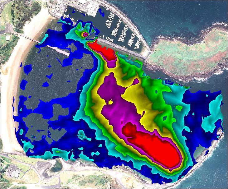
8 Figure 6 Spatial sediment accumulation within Coffs Harbour 8
 of 2.14m, a period (Tp) of 7.")
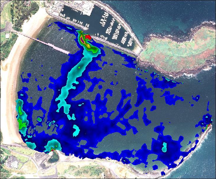
9 Part 3: Numerical Modelling The wave conditions and currents experienced within the harbour was analysed by creating a numerical model based on the latest bathymetric survey. 3.1 Spectral Wave Model Analysis A Flexible Mesh MIKE21 Spectral Wave Model of the harbour was created using the 2008 bathymetric survey. Three incident waves were used as boundary conditions, with a significant wave height (Hs) of 2.14m, a period (Tp) of 7.46 seconds and wave directions from the north-east, east and south-east (64 O 93 O and 154 O respectively), refer to Table 1. The absence of wave gauges the outer harbour did not allow full calibration of the model. A wave gauge does exist in the inner harbour, however it is positioned in an area of minimum wave influence and is used as a tide gauge. It was not deemed appropriate for use in this study. Table 1 Wave Events Modelled in Coffs Harbour MIKE21 Spectral Wave Model Scenario Hs (m) Tp (s) Dir. (Deg TN) Verification NE Swell Easterly Swell SE Swell Modelled Harbour Conditions Wave energy was seen to reduce upon entering the harbour, while north-easterly and easterly storm event waves penetrated the harbour further than the south-easterly event. The energy dissipation due to the orientation of the eastern breakwater is shown to be highly effective during south-easterly swell. Figure 7 shows wave penetration during the easterly and north-easterly wave events. (a) (b) Figure 7 North Easterly (a) and Easterly (b) Wave Penetration in the Harbour. Wave generated currents were observed to travel against the north and south boundaries of the harbour. North-easterly swells produced currents travelling against the southern boundary, and south-easterly swells against the northern boundary. Easterly swells produced currents travelling around both the northern and southern boundaries, which 9
), the Coffs Harbour Port - Shoal Management Planning Program (CHCC 2002) and the")
10 extend to run parallel past Jetty Beach. These currents supported previous studies including the Coffs Harbour Boat Ramp Siltation Investigation (AWACS 1995)), the Coffs Harbour Port - Shoal Management Planning Program (CHCC 2002) and the Specialist Coastal Engineering Advice for Harbourside Project Coffs Harbour (Carley et al 2005). High Particle Velocity High Particle Velocity Figure 8 North easterly (a) and easterly (b) swell event particle velocity at harbour bed Discussion and Conclusion The aims of the Coffs Harbour Sediment Modelling Investigation were to quantify and draw conclusions relating to the sediment entering and bypassing Coffs Harbour via LST. The use of solely empirical formula for determining LST has had mixed results. The results from Bayram (2007) have shown to give reasonable estimates of LST, while Kamphuis (1991) was found to overestimate. Bayram (2007) potential LST rates ranged from around 55, ,000m 3 /yr, similar to previously published rates of approximately 70,000m 3 /yr given by Carley et al (2005). The results produced by the CERC formula were extremely high. This supports criticism of the formula in papers such as Stutz and Pilkey (1999). The applicability of theoretical wave transformation and breaking calculations was a limitation of the study. To obtain more accurate results it is recommended that a numerical wave transformation model such as SWAN by Delft Hydraulics be used. Never-the-less, the results from Bayram formula produced a reasonable estimate of LST. The use of the GIS and volumetric analysis software as a method of comparing a time series of bathymetric surveys was successful, however the potential for error when digitizing and geo-referencing hardcopy maps could impact reliability of the data. Infilling rates in the harbour initially remained relatively small after the breakwater construction, which increased due to severe weather events during the 1970s. Sediment accumulation peaked around 48,000m 3 /yr during The infilling rate has appeared to have since decreased however this trend requires further analysis to be confirmed. The MIKE Spectral Wave Model, while uncalibrated, offered indications of wave behaviour and currents within the harbour. The orientation of the eastern breakwall significantly reduced wave energy during south-easterly events, while wave penetration was greatest during north-easterly and easterly wave events. Currents were observed to travel around the landward boundaries of the harbour, which may be a method of sediment transport towards Jetty Beach. These currents supported the proposed sediment transport currents in previous studies. 10
11 References 12d Solutions, 2011, 12d Model, 12d Solutions Pty Ltd Australian Coastal and Water Studies (AWACS), 1995, Coffs Harbour Boat Ramp and Siltation Investigation, Report 95/18 Bayram. A, Larson M., and Hanson H., 2007, A new formula for the total longshore sediment rate, Coastal Engineering, Vol. 54, Coffs Harbour Port Shoal Management Planning Program, 2002, Coffs Harbour City Council (CHCC) Coffs Harbour Working Group. Carley, J., Wyllie, S. and Cox, R., 2005, Specialist Coastal Engineering Advice for Harbourside Project Coffs Harbour, WRL Technical Report No 2005/21, Water Research Laboratory, University of New South Wales. Danish Hydraulic Institute, 2011, MIKE21 Spectral Wave Model, DHI Group Esri, 2010, ArcMap 10, Esri Inc. Kamphuis J., 2000, Introduction to Coastal Engineering and Management, World Scientific, Advanced Series on Ocean Engineering, Vol. 16 Lord, D.B. 1984, An Assessment of Harbour Infilling Resulting from Longshore Sediment Transport at Coffs Harbour, Master of Engineering Science Thesis, University of New South Wales. Short, A.D., 2007, Beaches of the New South Wales Coast: A guide to their nature, characteristics, surf and safety, 2nd Edition Stutz M.L. and Pilkey O.H., 1999, Discussion of: Wang, P; N.C. Kraus, and R.A. Davis Total Longshore Sediment Transport Rate in the Surf Zone: Field Measurements and Empirical Predictions. Journal of Coastal Research, 14 (1), , Journal of Coastal Research, Vol. 15, USACE, 1984, Shore Protection Manual, CO. Eng. Res. Centre, US Army Corps of Engineers, Vicksburg, MS, USA 11
COASTAL EROSION: INVESTIGATIONS IN THE SOUTHWEST COAST OF SRI LANKA
 COASTAL EROSION: INVESTIGATIONS IN THE SOUTHWEST COAST OF SRI LANKA Wijayawardane I.S.K. 1, Ansaf K.M.M. 2, Ratnasooriya A.H.R. 3, Samarawickrama S.P. 4 1,2 Postgraduate Student, Department of Civil Engineering,
Appendix E Cat Island Borrow Area Analysis
 Appendix E Cat Island Borrow Area Analysis ERDC/CHL Letter Report 1 Cat Island Borrow Area Analysis Multiple borrow area configurations were considered for Cat Island restoration. Borrow area CI1 is located
MIAMI BEACH 32ND STREET HOT SPOT: NUMERICAL MODELING AND DESIGN OPTIMIZATION. Adam Shah - Coastal Engineer Harvey Sasso P.E.
 ABSTRACT MIAMI BEACH 32ND STREET HOT SPOT: NUMERICAL MODELING AND DESIGN OPTIMIZATION Adam Shah - Coastal Engineer Harvey Sasso P.E. - Principal Coastal Systems International, Inc. 464 South Dixie Highway
Available online at ScienceDirect. Procedia Engineering 116 (2015 )
") Available online at www.sciencedirect.com ScienceDirect Procedia Engineering 116 (2015 ) 320 325 8th International Conference on Asian and Pacific Coasts (APAC 2015) Department of Ocean Engineering, IIT
Available online at www.sciencedirect.com ScienceDirect Procedia Engineering 116 (2015 ) 320 325 8th International Conference on Asian and Pacific Coasts (APAC 2015) Department of Ocean Engineering, IIT
COFFS HARBOUR BOAT RAMP LONG WAVE DATA COLLECTION TO EVALUATE PERFORMANCE OF BASIN EXTENSION WORKS
 COFFS HARBOUR BOAT RAMP LONG WAVE DATA COLLECTION TO EVALUATE PERFORMANCE OF BASIN EXTENSION WORKS M Kulmar 1, I Jayewardene 1, M Glatz 1, M Robertson 2 1 NSW Government, Manly Hydraulics Laboratory (MHL),
Physical Modeling of Nearshore Placed Dredged Material Rusty Permenter, Ernie Smith, Michael C. Mohr, Shanon Chader
 Physical Modeling of Nearshore Placed Dredged Material Rusty Permenter, Ernie Smith, Michael C. Mohr, Shanon Chader Research Hydraulic Engineer ERDC-Coastal Hydraulics Laboratory October 25,2012 Study
Nearshore Placed Mound Physical Model Experiment
 Nearshore Placed Mound Physical Model Experiment PURPOSE: This technical note describes the migration and dispersion of a nearshore mound subjected to waves in a physical model. The summary includes recommendations
IMPACTS OF COASTAL PROTECTION STRATEGIES ON THE COASTS OF CRETE: NUMERICAL EXPERIMENTS
 IMPACTS OF COASTAL PROTECTION STRATEGIES ON THE COASTS OF CRETE: NUMERICAL EXPERIMENTS Tsanis, I.K., Saied, U.M., Valavanis V. Department of Environmental Engineering, Technical University of Crete, Chania,
Concepts & Phenomena
 Concepts & Phenomena in coastal and port sedimentation R. Kamalian Ports and Maritime Organization of Iran and PIANC-Iran 7 9 December 2015 What is the problem? Many harbours have sedimentation problems
Coastal Wave Energy Dissipation: Observations and Modeling
 Coastal Wave Energy Dissipation: Observations and Modeling Jeffrey L Hanson US Army Corps of Engineers Field Research Facility USACE Field Research Facility Kent K. Hathaway US Army Corps of Engineers
Nearshore Morphodynamics. Bars and Nearshore Bathymetry. Sediment packages parallel to shore, that store beach sediment
 Nearshore Morphodynamics http://coastal.er.usgs.gov/bier/images/chandeleur-xbeach-lg.jpg Bars and Nearshore Bathymetry Sediment packages parallel to shore, that store beach sediment Can be up to 50 km
Appendix D: SWAN Wave Modelling
 Appendix D: SWAN Wave Modelling D.1 Preamble The Eurobodalla Shire Council area is subject to extreme waves originating from offshore storms. When swell waves approach the coast, they are modified by the
Shoreline Response to an Offshore Wave Screen, Blairgowrie Safe Boat Harbour, Victoria, Australia
 Shoreline Response to an Offshore Wave Screen, Blairgowrie Safe Boat Harbour, Victoria, Australia T.R. Atkins and R. Mocke Maritime Group, Sinclair Knight Merz, P.O. Box H615, Perth 6001, Australia ABSTRACT
PHYSICAL AND NUMERICAL MODELLING OF WAVE FIELD IN FRONT OF THE CONTAINER TERMINAL PEAR - PORT OF RIJEKA (ADRIATIC SEA)
") PHYSICAL AND NUMERICAL MODELLING OF WAVE FIELD IN FRONT OF THE CONTAINER TERMINAL PEAR - PORT OF RIJEKA (ADRIATIC SEA) DALIBOR CAREVIĆ (1), GORAN LONČAR (1), VLADIMIR ANDROČEC (1) & MARIN PALADIN (1) 1.
PHYSICAL AND NUMERICAL MODELLING OF WAVE FIELD IN FRONT OF THE CONTAINER TERMINAL PEAR - PORT OF RIJEKA (ADRIATIC SEA) DALIBOR CAREVIĆ (1), GORAN LONČAR (1), VLADIMIR ANDROČEC (1) & MARIN PALADIN (1) 1.
Passage Key Inlet, Florida; CMS Modeling and Borrow Site Impact Analysis
 Passage Key Inlet, Florida; CMS Modeling and Borrow Site Impact Analysis by Kelly R. Legault and Sirisha Rayaprolu PURPOSE: This Coastal and Hydraulics Engineering Technical Note (CHETN) describes the
BILLY BISHOP TORONTO CITY AIRPORT PRELIMINARY RUNWAY DESIGN COASTAL ENGINEERING STUDY
 Bâtiment Infrastructures municipales Transport Industriel Énergie Environnement BILLY BISHOP TORONTO CITY AIRPORT PRELIMINARY RUNWAY DESIGN COASTAL ENGINEERING STUDY N. Guillemette 1, C. Glodowski 1, P.
Volume and Shoreline Changes along Pinellas County Beaches during Tropical Storm Debby
 Volume and Shoreline Changes along Pinellas County Beaches during Tropical Storm Debby Ping Wang and Tiffany M. Roberts Coastal Research Laboratory University of South Florida July 24, 2012 Introduction
Comparison of Predicted and Measured Shoaling at Morro Bay Harbor Entrance, California
 Comparison of Predicted and Measured Shoaling at Morro Bay Harbor Entrance, California by Edward F. Thompson, Inocencio P. DiRamos, and Robert R. Bottin, Jr. PURPOSE: This Coastal and Hydraulics Engineering
Inlet Management Study for Pass-A-Grille and Bunces Pass, Pinellas County, Florida
 Inlet Management Study for Pass-A-Grille and Bunces Pass, Pinellas County, Florida Final Report Submitted By Ping Wang, Ph.D., Jun Cheng Ph.D., Zachary Westfall, and Mathieu Vallee Coastal Research Laboratory
DUXBURY WAVE MODELING STUDY
 DUXBURY WAVE MODELING STUDY 2008 Status Report Duncan M. FitzGerald Peter S. Rosen Boston University Northeaster University Boston, MA 02215 Boston, MA 02115 Submitted to: DUXBURY BEACH RESERVATION November
SELECTION OF THE PREFERRED MANAGEMENT OPTION FOR STOCKTON BEACH APPLICATION OF 2D COASTAL PROCESSES MODELLING
 SELECTION OF THE PREFERRED MANAGEMENT OPTION FOR STOCKTON BEACH APPLICATION OF 2D COASTAL PROCESSES MODELLING C Allery 1 1 DHI Water and Environment, Sydney, NSW Abstract This paper presents an approach
ACOUSTIC DOPPLER CURRENT PROFILING FROM KIRRA BEACH TO COOK ISLAND FIELD EXERCISES UNDERTAKEN BY THE TWEED RIVER ENTRANCE SAND BYPASSING PROJECT
 ACOUSTIC DOPPLER CURRENT PROFILING FROM KIRRA BEACH TO COOK ISLAND FIELD EXERCISES UNDERTAKEN BY THE TWEED RIVER ENTRANCE SAND BYPASSING PROJECT Z Helyer 1, C Acworth 1, K Nielsen 1, 1 Coastal Impacts
CHAPTER 134 INTRODUCTION
 CHAPTER 134 NEW JETTIES FOR TUNG-KANG FISHING HARBOR, TAIWAN Chi-Fu Su Manager Engineering Department Taiwan Fisheries Consultants, Inc. Taipei, Taiwan INTRODUCTION Tung-Kang Fishing Harbor, which is about
BYPASS HARBOURS AT LITTORAL TRANSPORT COASTS
 BYPASS HARBOURS AT LITTORAL TRANSPORT COASTS by K. Mangor 1, I. Brøker 2, R. Deigaard 3 and N. Grunnet 4 ABSTRACT Maintaining sufficient navigation depth in front of the entrance at harbours on littoral
Comparisons of Physical and Numerical Model Wave Predictions with Prototype Data at Morro Bay Harbor Entrance, California
 Comparisons of Physical and Numerical Model Wave Predictions with Prototype Data at Morro Bay Harbor Entrance, California by Robert R. Bottin, Jr. and Edward F. Thompson PURPOSE: This Coastal and Hydraulics
TWEED RIVER ENTRANCE AND BYPASS SEDIMENT DYNAMICS
 TWEED RIVER ENTRANCE AND BYPASS SEDIMENT DYNAMICS Ron Cox 1 and Dan Howe 1 A sediment budget analysis model was applied to the Tweed River entrance, and was used to evaluate different coastal management
Tweed River Entrance Sand Bypassing Long Term Average sand transport rate
 Tweed River Entrance Sand Bypassing Long Term Average sand transport rate D Patterson 1, P Boswood 2, G Elias 3 1 BMT WBM Pty Ltd, Brisbane, Qld 2 Department of Environment and Resource Management, Brisbane,
Simulating Long Waves in a Coffs Harbour 3D Physical Model Using Short Wave Spectra
 Journal of Shipping and Ocean Engineering 6 (2016) 15-21 doi 10.17265/2159-5879/2016.01.002 D DAVID PUBLISHING Simulating Long Waves in a Coffs Harbour 3D Physical Model Using Short Wave Spectra Indra
Longshore sediment transport
 and Orson P. Smith, PE, Ph.D., Professor Emeritus Longshore transport Waves breaking at an angle to shore Sediment under breakers lifted by saltation Drops back to sea bed a little down drift Swash (runup)
USE OF SEGMENTED OFFSHORE BREAKWATERS FOR BEACH EROSION CONTROL
 .. CETN-III-22 4/84 PURPOSE: USE OF SEGMENTED OFFSHORE BREAKWATERS FOR BEACH EROSION CONTROL To provide information on the functional application of and general design considerations for using offshore
Technical Brief - Wave Uprush Analysis Island Harbour Club, Gananoque, Ontario
 Technical Brief - Wave Uprush Analysis RIGGS ENGINEERING LTD. 1240 Commissioners Road West Suite 205 London, Ontario N6K 1C7 October 31, 2014 Table of Contents Section Page Table of Contents... i List
CHAPTER 281 INFLUENCE OF NEARSHORE HARDBOTTOM ON REGIONAL SEDIMENT TRANSPORT
 CHAPTER 281 INFLUENCE OF NEARSHORE HARDBOTTOM ON REGIONAL SEDIMENT TRANSPORT Paul C.-P. Lin, Ph.D., P.E. 1 and R. Harvey Sasso, P.E. 2 ABSTRACT The influence of nearshore hardbottom on longshore and cross-shore
Impacts of breakwaters and training walls
 Across the eastern seaboard of Australia, breakwaters and training walls have instigated fundamental perturbations to coastal and estuary processes. This has induced long-term changes to foreshore alignments,
The construction of Deepwater Navigation Channel (DNC) in the Bystry arm of the Danube Delta has started in The whole project provides the
 in the Bystry arm of the Danube Delta has started in The whole project provides the") Annex 45 Numerical Studies of Waves, Currents and Sediment Transport at the Marine Part of Deepwater Navigation Channel through the Bystry Arm of the Danube Delta and Model Verification based on Laboratory
Annex 45 Numerical Studies of Waves, Currents and Sediment Transport at the Marine Part of Deepwater Navigation Channel through the Bystry Arm of the Danube Delta and Model Verification based on Laboratory
EVALUATION OF THE CERC FORMULA USING LARGE-SCALE MODEL DATA
 EVALUATION OF THE CERC FORMULA USING LARGE-SCALE MODEL DATA Ernest R. Smith 1, Ping Wang 2, Jun Zhang 3 Abstract: Longshore transport experiments were conducted in a large-scale physical model to evaluate
Chapter 4 EM THE COASTAL ENGINEERING MANUAL (Part I) 1 August 2008 (Change 2) Table of Contents. Page. I-4-1. Background...
 1 August 2008 (Change 2) Table of Contents. Page. I-4-1. Background...") Chapter 4 EM 1110-2-1100 THE COASTAL ENGINEERING MANUAL (Part I) 1 August 2008 (Change 2) Table of Contents I-4-1. Background... Page I-4-1 a. Shore Protection Planning and Design, TR 4... I-4-1 b. Shore
Chapter 4 EM 1110-2-1100 THE COASTAL ENGINEERING MANUAL (Part I) 1 August 2008 (Change 2) Table of Contents I-4-1. Background... Page I-4-1 a. Shore Protection Planning and Design, TR 4... I-4-1 b. Shore
A Preliminary Review of Beach Profile and Hardbottom Interactions
 A Preliminary Review of Beach Profile and Hardbottom Interactions Douglas W. Mann, P.E., D.CE. CB&I A World of Solutions Presentation Goal Lead to a better understanding of the challenges regarding the
HARBOUR SEDIMENTATION - COMPARISON WITH MODEL
 HARBOUR SEDIMENTATION - COMPARISON WITH MODEL ABSTRACT A mobile-bed model study of Pointe Sapin Harbour, in the Gulf of St. Lawrence, resulted in construction of a detached breakwater and sand trap to
OCEAN WAVES NAME. I. Introduction
 NAME OCEAN WAVES I. Introduction The physical definition of a wave is a disturbance that transmits energy from one place to another. In the open ocean waves are formed when wis blowing across the water
Wave-dominated embayed beaches. Andrew D Short School of Geosciences University of Sydney
 Wave-dominated embayed beaches Andrew D Short School of Geosciences University of Sydney Wave-dominated embayed beaches wave-dominated beaches embayed beaches morphodynamics of W-D embayed beaches circulation,
Beach Wizard: Development of an Operational Nowcast, Short-Term Forecast System for Nearshore Hydrodynamics and Bathymetric Evolution
 Beach Wizard: Development of an Operational Nowcast, Short-Term Forecast System for Nearshore Hydrodynamics and Bathymetric Evolution Ad Reniers Civil Engineering and Geosciences, Delft University of Technology
Cross-shore sediment transports on a cut profile for large scale land reclamations
 Cross-shore sediment transports on a cut profile for large scale land reclamations Martijn Onderwater 1 Dano Roelvink Jan van de Graaff 3 Abstract When building a large scale land reclamation, the safest
THE WAVE CLIMATE IN THE BELGIAN COASTAL ZONE
 THE WAVE CLIMATE IN THE BELGIAN COASTAL ZONE Toon Verwaest, Flanders Hydraulics Research, toon.verwaest@mow.vlaanderen.be Sarah Doorme, IMDC, sarah.doorme@imdc.be Kristof Verelst, Flanders Hydraulics Research,
EVALUATION OF BEACH EROSION UP-DRIFT OF TIDAL INLETS IN SOUTHWEST AND CENTRAL FLORIDA, USA. Mohamed A. Dabees 1 and Brett D.
 EVALUATION OF BEACH EROSION UP-DRIFT OF TIDAL INLETS IN SOUTHWEST AND CENTRAL FLORIDA, USA Mohamed A. Dabees 1 and Brett D. Moore 1 The paper discusses the analysis of up-drift beach erosion near selected
INTRODUCTION TO COASTAL ENGINEERING
 The University of the West Indies Organization of American States PROFESSIONAL DEVELOPMENT PROGRAMME: COASTAL INFRASTRUCTURE DESIGN, CONSTRUCTION AND MAINTENANCE A COURSE IN COASTAL DEFENSE SYSTEMS I CHAPTER
LAB: WHERE S THE BEACH
 Name: LAB: WHERE S THE BEACH Introduction When you build a sandcastle on the beach, you don't expect it to last forever. You spread out your towel to sunbathe, but you know you can't stay in the same spot
Evaluation of June 9, 2014 Federal Emergency Management Agency Flood Insurance Study for Town of Weymouth, Norfolk, Co, MA
 Evaluation of June 9, 2014 Federal Emergency Management Agency Flood Insurance Study for Town of Weymouth, Norfolk, Co, MA Prepared For: Woodard & Curran 95 Cedar Street, Suite 100 Providence, RI 02903
MONITORING SEDIMENT TRANSPORT PROCESSES AT MANAVGAT RIVER MOUTH, ANTALYA TURKEY
 COPEDEC VI, 2003 in Colombo, Sri Lanka MONITORING SEDIMENT TRANSPORT PROCESSES AT MANAVGAT RIVER MOUTH, ANTALYA TURKEY Isikhan GULER 1, Aysen ERGIN 2, Ahmet Cevdet YALCINER 3 ABSTRACT Manavgat River, where
CMS Modeling of the North Coast of Puerto Rico
 CMS Modeling of the North Coast of Puerto Rico PRESENTED BY: Dr. Kelly Rankin Legault, Ph.D., P.E. 1 Dr. Alfredo Torruella, Ph.D. 2 1 USACE Jacksonville District 2 University of Puerto Rico October 2016
Shoreline Evolution Due to Oblique Waves in Presence of Submerged Breakwaters. Nima Zakeri (Corresponding Author), Mojtaba Tajziehchi
, Mojtaba Tajziehchi") Shoreline Evolution Due to Oblique Waves in Presence of Submerged Breakwaters Nima Zakeri (Corresponding Author), Mojtaba Tajziehchi Department of Civil Engineering, Faculty of Engineering, University
Shoreline Evolution Due to Oblique Waves in Presence of Submerged Breakwaters Nima Zakeri (Corresponding Author), Mojtaba Tajziehchi Department of Civil Engineering, Faculty of Engineering, University
Technical Brief - Wave Uprush Analysis 129 South Street, Gananoque
 Technical Brief - Wave Uprush Analysis 129 South Street, Gananoque RIGGS ENGINEERING LTD. 1240 Commissioners Road West Suite 205 London, Ontario N6K 1C7 June 12, 2013 Table of Contents Section Page Table
Appendix M: Durras Lake Tailwater Conditions
 Appendix M: Durras Lake Tailwater Conditions M.1 Preamble WRL has completed a tailwater condition assessment for the entrance to Durras Lake, to be used as an ocean boundary condition for a future flood
Advanced Series on Ocean Engineering - Volume 14 COASTAL STABILIZATION. Richard Silvester John R C Hsu. \v? World Scientific
 Advanced Series on Ocean Engineering - Volume 14 COASTAL STABILIZATION Richard Silvester John R C Hsu \v? World Scientific Contents PREFACE xv 1 INTRODUCTION 1 /. / Coastal Environment 2 J.2 State of Beach
Technical Note AN EMPIRICAL. METHOD FOR DESIGN OF BREAKWATERS AS SHORE PROTECTION STRUCTURES
 CETN III-23 (Rev 3/95) Coastal Engineering Technical Note AN EMPIRICAL. METHOD FOR DESIGN OF BREAKWATERS AS SHORE PROTECTION STRUCTURES PURPOSE: To present an empirical method that can be used for preliminary
CROSS-SHORE SEDIMENT PROCESSES
 The University of the West Indies Organization of American States PROFESSIONAL DEVELOPMENT PROGRAMME: COASTAL INFRASTRUCTURE DESIGN, CONSTRUCTION AND MAINTENANCE A COURSE IN COASTAL DEFENSE SYSTEMS I CHAPTER
SWASH MODELLING OF A COASTAL PROTECTION SCHEME
 SWASH MODELLING OF A COASTAL PROTECTION SCHEME Mark Klein 1, Andrew Symonds 2, Marcel Zijlema 3, Dan Messiter 4 and Michael Dufour 5 The Beresford shoreline, Australia, is subject to a complex interaction
To: William Woods, Jenni Austin Job No: CentrePort Harbour Deepening Project - Comments on community queries
 Memo To: William Woods, Jenni Austin From: Richard Reinen-Hamill Date: Subject: cc: 1 Purpose This memo sets out our response to issues raised at and after Seatoun community consultation sessions held
STORM RESPONSE SIMULATION
 APPENDIX V STORM RESPONSE SIMULATION Final Environmental Impact Statement Village of Bald Head Island Shoreline Protection Project Brunswick County, North Carolina Delft3D Storm Response Simulations With
Wave Energy Atlas in Vietnam
 Wave Energy Atlas in Vietnam Nguyen Manh Hung, Duong Cong Dien 1 1 Institute of Mechanics, 264 Doi Can Str. Hanoi, Vietnam nmhungim@gmail.com; duongdienim@gmail.com Abstract Vietnam has achieved remarkable
The Islands. Barbados. A prefeasibility study. R. Drieman M. Hinborch M. Monden E.A.J. Vendrik
 The Islands Barbados A prefeasibility study R. Drieman M. Hinborch M. Monden E.A.J. Vendrik General notice to the reader: In the academic programme for Hydraulic Engineering we have in the 4th year (i.e.
Hydrodynamic and hydrological modelling to support the operation and design of sea ports
 Hydrodynamic and hydrological modelling to support the operation and design of sea ports Data needs and examples Martijn de Jong (port/nautical requirements, waves, currents) Sofia Caires (mean and extreme
TRANSPORT OF NEARSHORE DREDGE MATERIAL BERMS
 Proceedings of the 6 th International Conference on the Application of Physical Modelling in Coastal and Port Engineering and Science (Coastlab16) Ottawa, Canada, May 10-13, 2016 Copyright : Creative Commons
CHAPTER 132. Roundhead Stability of Berm Breakwaters
 CHAPTER 132 Roundhead Stability of Berm Breakwaters Jergen Juhl 1, Amir Alikham, Peter Sloth, Renata Archetti Abstract Three-dimensional (3D) model tests were carried out for studying the stability of
Undertow - Zonation of Flow in Broken Wave Bores
 Lecture 22 Nearshore Circulation Undertow - Zonation of Flow in Broken Wave Bores In the wave breaking process, the landward transfer of water, associated with bore and surface roller decay within the
SORTING AND SELECTIVE MOVEMENT OF SEDIMENT ON COAST WITH STEEP SLOPE- MASUREMENTS AND PREDICTION
 SORTING AND SELECTIVE MOVEMENT OF SEDIMENT ON COAST WITH STEEP SLOPE- MASUREMENTS AND PREDICTION Toshiro San-nami 1, Takaaki Uda 2, Masumi Serizawa 1 and Toshinori Ishikawa 2 Conveyer belts carrying gravel
Feasibility Study for Dredging of Khaprabhanga Chapalir Don River in Patuakhali District for Improvement of Navigability
 IOSR Journal of Engineering (IOSRJEN) ISSN (e): 2250-3021, ISSN (p): 2278-8719 Vol. 04, Issue 06 (June. 2014), V3 PP 32-38 www.iosrjen.org Feasibility Study for Dredging of Khaprabhanga Chapalir Don River
Wave Transformation, Prediction, and Analysis at Kaumalapau Harbor, Lanai, Hawaii
 Wave Transformation, Prediction, and Analysis at Kaumalapau Harbor, Lanai, Hawaii Jessica H. Podoski, P.E. Coastal Engineer, USACE Honolulu District Christopher Goody, P.E. Sea Engineering, Inc. Thomas
THE HYDRAULIC AND MORPHOLOGICAL RESPONSE OF A LARGE COASTAL LAKE TO RISING SEA LEVELS
 THE HYDRAULIC AND MORPHOLOGICAL RESPONSE OF A LARGE COASTAL LAKE TO RISING SEA LEVELS Mr Evan K Watterson 1 Dr Joanna M Burston 1 Ms Heather Stevens 2 Mr Dan J Messiter 1 1 Author affiliation: WorleyParsons
INTRODUCTION TO COASTAL ENGINEERING AND MANAGEMENT
 Advanced Series on Ocean Engineering Volume 16 INTRODUCTION TO COASTAL ENGINEERING AND MANAGEMENT J. William Kamphuis Queen's University, Canada World Scientific Singapore New Jersey London Hong Kong Contents
Modeling Sediment Transport Along the Upper Texas Coast
 Modeling Sediment Transport Along the Upper Texas Coast David B. King Jr. Jeffery P. Waters William R. Curtis Highway 87 roadbed, Jefferson County Galveston District Corps Sabine Pass to San Luis Pass
April 7, Prepared for: The Caribbean Disaster Emergency Response Agency Prepared by: CEAC Solutions Co. Ltd.
 April 7, 2006 Prepared for: The Caribbean Disaster Emergency Response Agency Prepared by: Introduction CEAC Solutions Co. Ltd was commissioned in May 2005 to prepare coastal beach erosion hazard maps for
RAINBOW BAY FIELD REPORT
 RAINBOW BAY FIELD REPORT Contents Page Abstract 1.0 Introduction.. 2.0 Methodology 2.1 Limitations.. 3.0 Statement of Findings. 3.1 History. 3.2 Data Collection. 3.2.1 Observations. 3.2.2 Management Strategies
MODELING OF CLIMATE CHANGE IMPACTS ON COASTAL STRUCTURES - CONTRIBUTION TO THEIR RE-DESIGN
 Proceedings of the 14 th International Conference on Environmental Science and Technology Rhodes, Greece, 3-5 September 2015 MODELING OF CLIMATE CHANGE IMPACTS ON COASTAL STRUCTURES - CONTRIBUTION TO THEIR
INVESTIGATING STRATEGIES TO REPAIR HISTORIC TIDE WALLS ON THE CLARENCE RIVER AND ADJACENT BEACH AND RIVER BANK PROTECTION
 INVESTIGATING STRATEGIES TO REPAIR HISTORIC TIDE WALLS ON THE CLARENCE RIVER AND ADJACENT BEACH AND RIVER BANK PROTECTION I Jayewardene 1, A Hartley 2, B Blumberg 1, E Couriel 1 1 NSW Water Solutions,
Wave Setup at River and Inlet Entrances Due to an Extreme Event
 Proceedings of International Conference on Violent Flows (VF-2007) Organized by RIAM, Kyushu University, Fukuoka, Japan Wave Setup at River and Inlet Entrances Due to an Extreme Event Xuan Tinh Nguyen
Tanya M. Beck. Kelly Legault. Research Physical Scientist Coastal & Hydraulics Lab, ERDC Vicksburg, MS
 Inlet And Adjacent Shoreline Processes at Cascading Time Scales Using the Coastal Modeling System and GenCade Tanya M. Beck Research Physical Scientist Coastal & Hydraulics Lab, ERDC Vicksburg, MS Kelly
Undertow - Zonation of Flow in Broken Wave Bores
 Nearshore Circulation Undertow and Rip Cells Undertow - Zonation of Flow in Broken Wave Bores In the wave breaking process, the landward transfer of water, associated with bore and surface roller decay
An integrated three-dimensional model of wave-induced pore pressure and effective stresses in a porous seabed: II. Breaking waves
 An integrated three-dimensional model of wave-induced pore pressure and effective stresses in a porous seabed: II. Breaking waves Author Jeng, D., Zhang, Hong Published 2005 Journal Title Ocean Engineering
New Jersey Coastal Zone Overview. The New Jersey Beach Profile Network (NJBPN) 3 Dimensional Assessments. Quantifying Shoreline Migration
 3 Dimensional Assessments. Quantifying Shoreline Migration") New Jersey Coastal Zone Overview The New Jersey Beach Profile Network (NJBPN) Objectives Profile Locations Data Collection Analyzing NJBPN Data Examples 3 Dimensional Assessments Methodology Examples Quantifying
New Jersey Coastal Zone Overview The New Jersey Beach Profile Network (NJBPN) Objectives Profile Locations Data Collection Analyzing NJBPN Data Examples 3 Dimensional Assessments Methodology Examples Quantifying
LABORATORY EXPERIMENTS ON EROSION CONTROL PERFORMANCE OF AN L- SHAPED PERMEABLE STRUCTURE. Abstract
 LABORATORY EXPERIMENTS ON EROSION CONTROL PERFORMANCE OF AN L- SHAPED PERMEABLE STRUCTURE Yuuji Maeda 1, Masayuki Unno 2, Masafumi Sato 2, Takao Kurita 2, Takaaki Uda 3 and Shinji Sato 4 Abstract A new
CALCASIEU SALINITY STRUCTURES. HYDRODYNAMIC MODELING (To Support Design of Salinity Barriers)
") CALCASIEU SALINITY STRUCTURES HYDRODYNAMIC MODELING (To Support Design of Salinity Barriers) Presentation Overview 1 2 3 4 5 Project Overview and CEA Circulation Modeling Vessel Hydrodynamics Modeling
CALCASIEU SALINITY STRUCTURES HYDRODYNAMIC MODELING (To Support Design of Salinity Barriers) Presentation Overview 1 2 3 4 5 Project Overview and CEA Circulation Modeling Vessel Hydrodynamics Modeling
HYDRODYNAMICS AND MORPHODYNAMICS IN THE SURF ZONE OF A DISSIPATIVE BEACH
 HYDRODYNAMICS AND MORPHODYNAMICS IN THE SURF ZONE OF A DISSIPATIVE BEACH Leo C. van Rijn, Dirk Jan R. Walstra, Bart T. Grasmeijer and Kees Kleinhout Abstract: Two profile models have been compared with
THE EXPANSION OF THE PORT OF HANSTHOLM THE FUTURE CONDITIONS FOR A BYPASS HARBOUR
 THE EXPANSION OF THE PORT OF HANSTHOLM THE FUTURE CONDITIONS FOR A BYPASS HARBOUR Bo Brahtz Christensen 1, Rolf Deigaard 1, Ida Brøker 1, Kasper Kærgaard 1, Asger Bendix Hansen 1, Nils Drønen 1, Anders
Wave behaviour in the inner surf zone
 Wave behaviour in the inner surf zone Hannah POWER 1 and Michael HUGHES 2 Abstract: The inner surf zone is a critical component of models that are used to predict nearshore wave behaviour and beach morphodynamics.
CORPS FACTS. Harbor Dredging U.S. ARMY CORPS OF ENGINEERS BUILDING STRONG
 CORPS FACTS Harbor Dredging U.S. ARMY CORPS OF ENGINEERS BUILDING STRONG Disaster Response Sedimentation in the channel is caused by the normal cycle of silt movement, erosion from high water or heavy
CHAPTER 179. Performance of a Submerged Breakwater for Shore Protection
 CHAPTER 179 Abstract Performance of a Submerged Breakwater for Shore Protection Albert E. Browder',A. Member, ASCE; Robert G. Dean 2, Member, ASCE; and Renjie Chen 3 A summary is presented of the results
STUDY ON TSUNAMI PROPAGATION INTO RIVERS
 ABSTRACT STUDY ON TSUNAMI PROPAGATION INTO RIVERS Min Roh 1, Xuan Tinh Nguyen 2, Hitoshi Tanaka 3 When tsunami wave propagation from the narrow river mouth, water surface is raised and fluctuated by long
LOCALLY CONCENTRATED SEVERE BEACH EROSION ON SEISHO COAST CAUSED BY TYPHOON T0709
 F-4 Fourth International Conference on Scour and Erosion 2008 LOCALLY CONCENTRATED SEVERE BEACH EROSION ON SEISHO COAST CAUSED BY TYPHOON T0709 Yoshimitsu TAJIMA 1 and Shinji SATO 2 1 Member of JSCE, Associate
LITTLE LAGOON & LITTLE LAGOON PASS: RESEARCH UPDATES & DIRECTIONS
 LITTLE LAGOON & LITTLE LAGOON PASS: RESEARCH UPDATES & DIRECTIONS Bret M. Webb, PhD, PE, DCE Professor Department of Civil, Coastal, and Environmental Engineering October 19, 2017 LLPS Meeting Acknowledgments
Inspection of Clarence City Beaches following Winter 2011 Storm Events
 18 July 2011 WRL Ref: WRL10086TDS L20110718 Messrs P Watson & I Preece Clarence City Council PO Box 96 Rosny Park TAS 7018 By email: pwatson@ccc.tas.gov.au ipreece@ccc.tas.gov.au Dear Phil/Ian, Inspection
Nearshore Dredged Material Placement Pilot Study at Noyo Harbor, CA
 1 Nearshore Dredged Material Placement Pilot Study at Noyo Harbor, CA Noyo Cove N 2011 National Conference on Beach Preservation Technology 9-11, February 2011 Lihwa Lin, Honghai Li, Mitchell Brown US
SHORE PROTECTION AND HABITAT CREATION AT SHAMROCK ISLAND, TEXAS ABSTRACT
 SHORE PROTECTION AND HABITAT CREATION AT SHAMROCK ISLAND, TEXAS M. Cameron Perry, P.E., and Daniel J. Heilman, P.E. Coastal Engineer Shiner Moseley & Associates., Inc. 555 N. Carancahua Corpus Christi,
page - Laboratory Exercise #5 Shoreline Processes
 page - Laboratory Exercise #5 Shoreline Processes Section A Shoreline Processes: Overview of Waves The ocean s surface is influenced by three types of motion (waves, tides and surface currents). Shorelines
Using UNIBEST and Delft3D
 5 th Delft3D-OSS webinar Large scale long-term coastline modelling Using UNIBEST and Delft3D 14 March 2012 Aims Basic information on CL-models Model setup Trigger discussion > Delft3D = open source > UNIBEST
Earth Science Chapter 16 Section 3 Review
 Name: Class: Date: Earth Science Chapter 16 Section 3 Review Multiple Choice Identify the choice that best completes the statement or answers the question. 1. The movement of water that parallels the shore
Artificial headlands for coastal restoration
 Artificial headlands for coastal restoration J. S. Mani Professor, Department of Ocean Engineering, Indian Institute of Technology Madras, Chennai 636, India Abstract Construction of a satellite harbour
Australian Coastal Councils Conference
 Australian Coastal Councils Conference Kiama March 2019 Where Has My Beach Gone? (and what can I do about it?) Dr Andrew McCowan Water Technology Where Has My Beach Gone? Where Has My Beach Gone? Where
ANALYSIS OF MECHANISM OF SAND DEPOSITION INSIDE A FISHING PORT USING BG MODEL
 Proceedings of the 7 th International Conference on Asian and Pacific Coasts (APAC 2013) Bali, Indonesia, September 24-26, 2013 ANALYSIS OF MECHANISM OF SAND DEPOSITION INSIDE A FISHING PORT USING BG MODEL
Environmental Protection on the Gold Coast of Queensland, Australia. 1. What is the appeal of the Gold Coast to tourists?
 Environmental Protection on the Gold Coast of Queensland, Australia Sections 1. What is the appeal of the Gold Coast to tourists? 2. How are Gold Coast visitor trends changing? 3. How can the impacts of
Coastal & Marine Environment. Chapter. Wave Transformation. Mazen Abualtayef Assistant Prof., IUG, Palestine
 Coastal & Marine Wave Transformation Mazen Abualtayef Assistant Prof., IUG, Palestine Wave Transformation Wave transformation describes what happens to waves as they travel from deep into shallow water