Modeling Wind and Tidal Circulation in Casco Bay, Maine: a preliminary study
|
|
|
- Erick Curtis
- 6 years ago
- Views:
Transcription
1 Modeling Wind and Tidal Circulation in Casco Bay, Maine: a preliminary study Ernest D. Truea, James P. Manningb a Mathematics Dept., Norwich University, Northfield, VT USA b Northeast Fisheries Science Center, Woods Hole, MA USA Abstract One of the most important coastal regions along the 3500 mile coast of Maine is Casco Bay, which covers approximately 229 square miles with hundreds of islands, islets and exposed ledges. Casco Bay includes the entrance to Portland Harbor at the western corner of the Bay. Commercial fishing, aquaculture farms, recreational activities and imports and exports of numerous commodities through Portland Harbor make this bay one of the busiest regions on the Maine coast. There is speculation that the red tide occurrences within the Bay are due to germination of local cysts or intrusion from offshore waters, or both. The purpose of this study is to offer a preliminary investigation of the general circulation of the waters in the Bay by applying a finite volume numerical coastal model (FVCOM) that incorporates bathymetry, tidal forcing, wind stress and river discharge from the Kennebec/Androscoggin River east of the Bay. The horizontal resolution of coastline and island boundaries used in the study is sufficient to capture small eddy production and decay, and identify local circulation dynamics. The focus is on the Spring circulation, with particular attention given to possible paths that move A. fundyense into and out of the Bay. The influences of wind, tide, and Kennebec/Androscoggin river intrusion are examined separately. The Portland Channel, Hussey Sound, Luckse Sound and Broad Sound provide four pathways for the exchange of water between the inner and outer regions of the Bay. With a steady wind from the northeast, and no tidal forcing, a counterclockwise circulation sets up, with flow mainly entering the inner bay through Broad Sound and out through Portland Channel. A reverse flow is observed along the bottom layers just south of Broad Sound. When only tidal forcing is applied, there is flow through all channels into the inner bay during flood tide, with volume transports more in proportion to the size of the channels. The tidal flows generally show little change in direction with depth. When a northeast wind is superimposed on the flood tide to create an across shelf downwelling favorable event, the flow on the ebb tide produces a strong current on the order of 60 cm/s flowing out of Portland Channel. Volume transports through the major channels are presented for comparisons. The influence of the Kennebec/Androscoggin River discharge on the circulation in Casco Bay is given a very preliminary study. A tracer tracking module in FVCOM is used to simulate the injection of a dye at the mouth of the river, which was subsequently tracked for eight days. In the presence of tidal forcing and a wind field that simulates the northeaster of May , the dye patch penetrates and disperses well into the eastern portion of Casco Bay, suggesting a surface layer
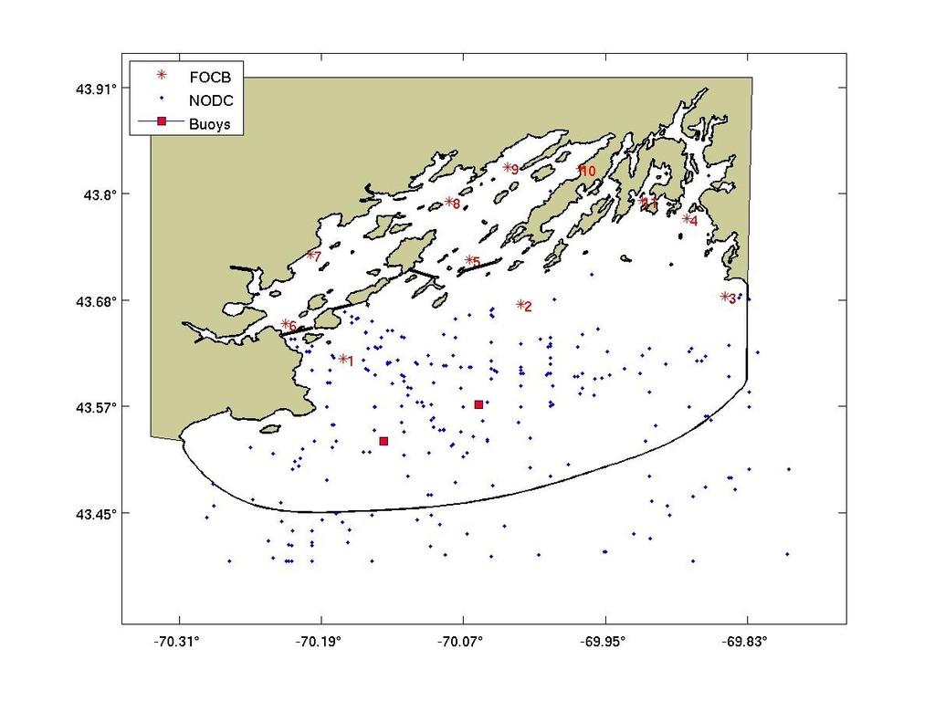
2 conveyance for plankton species throughout the eastern region of the Bay. 1. Introduction and background Casco Bay in Maine is one of the busiest and most commercially productive regions along the Maine coast (Fig. 1). Portland is the largest city in the state, with Portland Harbor at the southwest end of the Bay. According to the Maine Port Authority, the Port of Portland is the largest foreign inbound tonnage transit port in the United States, the largest tonnage port in New England, and the largest oil port on the US East Coast. It annually handles over 200,000 international passengers, and 2300 cargo containers onto nearby rail systems. Oil tankers deliver approximately 28 million tons of oil products, and cargo ships deliver 800,000 tons of dry bulk cargo. The Portland Fish Exchange, where commercial fishermen can deliver their catches for auction to wholesalers, handles about 20 million pounds of seafood per year. The Maine Department of Marine Resources (DMR 2006) reports that the Bay produces approximately thirteen percent of all commercial lobster catches in the state. There are twelve aquaculture farms within the Bay, primarily for shellfish production. The abundance of shipping, fishing and recreation in the Bay and its economic impact on the greater Portland area presents a good case for continued study of its tidal and non tidal currents. Casco Bay has also been an area in which large cell counts of Alexandrium fundyense have been recorded (Doucette et al., 2005; Anderson et al., 2005), such as in the northeastern region at Lumbo s Hole in Harpswell Sound and at the mouth of the New Meadows River. The closing of parts of Casco Bay to commercial shellfishing because of paralytic shellfish poisoning (PSP) is not uncommon. The presence of A. fundyense in the Bay has led to some conceptual models of potential pathways of PSP toxins into and out of the Bay. The Western Maine Coastal Current (WMCC) lies just seaward of the outer boundary of this study. Although the influence of the WMCC is not addressed in this work, a high resolution circulation model of the Bay provides a first step toward a future examination of possible pathways associated with the WMCC and Casco Bay. 2. Recent studies and available data In , a team from the Bigelow Laboratories for Ocean Sciences conducted a survey of the Bay that included 197 hydrographic stations, 887 hours of tracking current drogues and 2369 hours of measuring bottom currents with eulerian current meters at ten locations (Parker, 1982). This report describes the velocity field and density contours during flooding and ebbing within the Bay. The Friends of Casco Bay (FOCB) is an environmental organization working to improve and protect the environmental health of Casco Bay. Trained volunteers from FOCB have been collecting temperature, salinity, dissolved oxygen, ph and water clarity at ten profile stations since 1992 (Fig. 2). The Casco Bay Estuary Partnership (CBEP), which partially supports FOCB, has as its mission the protection and restoration of water quality, and fish and wildlife habitat in the Bay. The CBEP has funded and published numerous papers on air and water quality for the Bay. The hydrographic data for Casco Bay is quite sparse. A recent review of the NODC data for the Casco Bay area shows 459 stations recording hydrographic data from 1912 to 2001, many of which
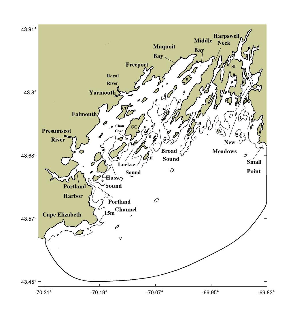
3 are seaward of the 60 m isobath. Of these, only 325 stations include both temperature and salinity, from which density could be determined to initialize the numerical model used in this study. From these 325 temperature salinity stations, there were 116 stations in 1953, 45 in 1954, 18 in 1979, 16 in 1991 and 23 in The remaining years each had fewer than 10 stations. There were only 30 stations that had readings during the May June season. Hence, the archived NODC data for this region was not sufficient spatially and temporally to initialize the numerical model for the Spring season. There are two buoys east of the major islands of the Bay that provide wind and other meteorological data. One is maintained by the National Data Buoy Center (NDBC station 44007), and the other by the Gulf of Maine Ocean Observing System (GOMOOS, station 44031). There is a tide gauge on the Maine State Pier in Portland harbor (National Ocean Service station ). As part of the ECOHAB GOM project, CTD surveys were conducted in 1998 and 2000 in the New Meadows estuary and southeast of Casco Bay to examine the exchange of water between Casco Bay and the Gulf of Maine inner shelf in search of possible pathways of A. fundyense into coastal waters (Geyer et al. 2004, Janzen et al., 2005). 3. Geometry of Casco Bay The region for this study covers Casco Bay and is closed by an outer boundary from Cape Elizabeth to Cape Small (Fig. 1). The curved outer boundary is close to the 80 m isobath. The surface area, excluding the 75 islands used here, is about 1200 km2 ( 463 square miles). The average depth within the study site is approximately 24 m. The deepest spot is 118 m located at about the center of the outer boundary. A southwesterly Gulf of Maine Coastal Plume (GOMCP) has been suggested by Keafer (2005). If it is present, it would lie just seaward of this outer boundary, while the adjacent WMCC (Lynch et al., 1997; Geyer et al., 2004), also flows southwesterly farther offshore near the 100 m isobath. 3.1 Bottom topography This section of the Maine coast is underlain by metamorphic rocks formed during ancient mountain building processes associated with southeast to northwest compression (Westerman). Subsequent movement along the Norumbega Fault zone further organized the alignment of the steeply dipping geologic units. Recent glaciation, including the region that is now below sea level, further scoured the valleys and smoothed the ridges to produce strongly aligned and elongated islands and peninsulas along the coast in a northeast to southwest direction. The bottom sediment close to shore and within the inner bays is primarily made up of clay with sand (USGS), and transitions more to sand and gravel offshore. The 15 m isobath as shown in Figure 1 is displayed to visualize three important passage ways for deep water intrusion into the inner bay, Hussey Sound, Luckse Sound, and Broad Sound. The middle channel of Broad Sound extends to a depth of 30 m and continues south to deeper water outside the Bay. Although Portland Channel is shallower and narrow, there are strong wind generated and tidal currents that can also move large volumes of water into the inner bay. Of course, these channels also allow exchange between offshore and bay waters at all depths. There is also a channel as
4 deep as 15 m or more that moves up into the New Meadows River. This narrow channel with numerous bays, ledges and islands has been identified as one area where high concentrations of Alexandrium cells (Turner et al ) have been recorded. The near coastal waters from Yarmouth northeast to the upper reaches of Maquoit and Middle Bay are generally less than 3 m in depth, and experience strong currents during flooding and ebbing. Because the Bay is wide open to the Gulf of Maine, the circulation of the waters within the Bay can be affected by offshore winds, fresh water runoff from the Kennebec/Androscoggin River, especially in spring, and meanders of the nearby western Maine coastal current(wmcc). 3.2 The tides A sample of the hourly tidal recordings at the Portland tide gauge is shown in Figure 3 for May The major tidal constituent is the semi diurnal lunar tide (M 2) with a period of hours. The water levels at this gauge can range up to 2.3 m above mean sea level. 4. The Numerical Model For this study, the FVCOM numerical model is applied on an unstructured triangular grid of Casco Bay. FVCOM, developed by Chen et al. (2003), is a prognostic, unstructured grid, finite volume, free surface, three dimensional primitive equation coastal and estuarine model. The default setup applies the Mellor and Yamada (1982) level 2.5 turbulent model scheme for vertical mixing, and the Smagorinsky (1963) scheme for horizontal mixing. The model allows for a wet/dry treatment in the intertidal zone, river discharge as a point source with separate temperature/salinity assignments, and hourly wind stress applied uniformly across the surface of the computational domain. The computational domain for the Bay is represented by a high resolution triangular unstructured mesh of 21,245 nodes and 38,762 triangles. The triangular grid was created using Triangle (Shewchuk) and BATTRI (Smith et al.), a graphical Matlab interface for Triangle. The domain is enclosed by the boundary curves as shown in Figure 1. The vertical structure is represented by using 9 terrain following equally spaced levels at each nodal depth. The shoreline and islands are sampled with nodes at intervals of 150 m or less, and generally at intervals of 450 m along the outer boundary. The curved outer boundary connects Cape Elizabeth with Cape Small. The straight line distance from Cape Elizabeth to Cape Small is about 43 km. The data for the bottom topography comes from the National Geophysical Data Center (NGDC) U.S. Coastal Relief Model, which provides a bottom topography on 90 m resolution square grids. 5. The Wind Generated Velocity Field In the Spring of 2005, Anderson et al. (2005) refer to two northeasters that may have contributed to high Alexandrium fundyense concentrations along the western Maine coast. The GOMOOS buoy in Casco Bay recorded strong winds for May 7 8 and again for May out of the northeast quadrant. From noon on May 7 through May 8, the hourly wind speed ranged from 10 m/s to 15 m/s with an average of 10.8 m/s. Likewise, from May 24 through noon on May 26 the wind out of the northeast quadrant averaged 10.6 m/s. In order to examine the effect that wind alone has on the
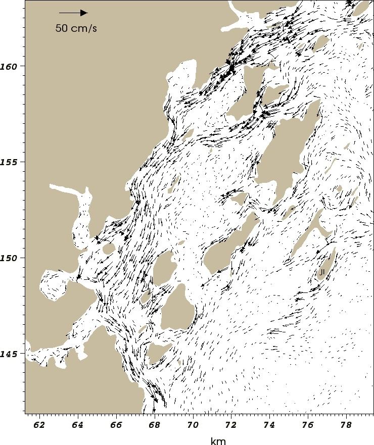
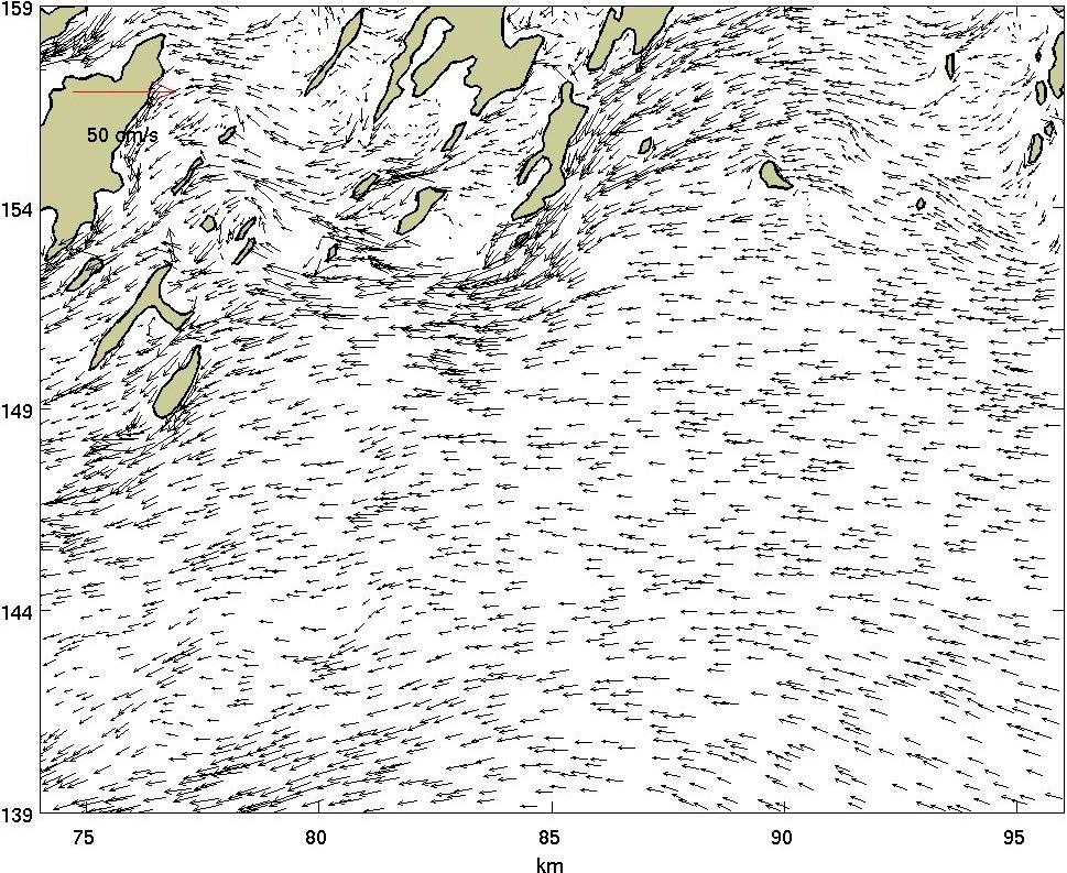
5 circulation in Casco Bay, the FVCOM model was run with a conservative wind speed of 8 m/s from the northeast, applied uniformly across the Bay for twenty four hours. For the next twenty four hours, a wind of 8 m/s coming from the southwest was applied, to see how the circulation adjusted from a northeast to a southwest wind change. The Coriolis acceleration is also applied, but tidal and baroclinic forcing, are not present. Also, fresh water intrusion from the Kennebec/Androscoggin River just east of Cape Small has not been included. With the wind coming from the northeast, the major features of the wind driven model circulation begin to reach a near steady state after about 6 hours. The result is a major circulation of a large counterclockwise flow entering Casco Bay from the northeast outer boundary south of Cape Small and exiting through the southwest boundary near Cape Elizabeth. Because of the size and complexity of the Bay with all its islands and coves, it is more convenient to view the circulation in two sections. The vertically integrated velocities along the western and eastern halves of the Bay are shown in Figures 4a and 4b, respectively. The northeast wind stress and Coriolis acceleration set up the Ekman dynamics, as water from offshore moves across shelf into the Bay south of Cape Small, and continues westerly where it veers around Bailey Island (see BI, Fig. 4b). Some of this flow continues through Broad Sound and into Middle Bay, while a smaller branch moves south of Jewell Island (see JI. Fig. 4a) and continues in a southwesterly direction parallel to the shoreline. The water in Middle Bay and Maquoit Bay is piled against the western shore, contributing to a strong southwesterly flow up to 30 cm/s along the Yarmouth and Falmouth shore that exits predominately through the Portland Channel and, to a lesser degree, through Hussey Sound, eventually leaving the computational domain at Cape Elizabeth. In Maquoit Bay and Middle Bay there is a complex circulation, as seen in the closer view of Figure 4c where more vector plots are displayed. In Middle Bay, the water piles up on the western shore and flows southwesterly out of the Bay where some of it turns clockwise and flows into the center of Maquoit Bay. The water flowing out of Middle Bay is being replenished with offshore water entering through Broad Sound. This inflow enters Middle Bay east of Birch and White islands, where it then diverges and creates a counterclockwise circulation on the west side of the Bay and a clockwise circulation on the east side. In a similar way, the water from Middle Bay that flows into the center of Maquoit Bay diverges and sets up a dipole pair of eddies. The fairly high resolution of the mesh used here identifies numerous small eddies throughout the inner bay due in part to the changing topography and islands, too complex to show in detail here. As one example, Figure 4d shows three clockwise eddies each about 1 km in diameter along the shore from Cape Small to the entrance of the New Meadows River estuary. As expected, this northwest wind sets up downwelling events along the western shores, with bottom waters along the coast moving offshore. The wind driven flow east of the islands in the deeper waters is also strongly influenced by the bathymetry. To illustrate the speed and direction of the wind driven current with depth, Figures 5a d show the vector field at the four depths of 1m, 10m, 25m, and 35m in a section east of Great Chebeague Island (see GC, Fig.1) out to the outer boundary south of Cape Small where the offshore waters enter the eastern half of the Bay. Broad Sound is just east of Great Chebeague Island. At a depth of 1m, the fairly uniform flow is across shelf into the Bay. At 10 m, the flow in the northern part of this section turns clockwise toward the entrance to the New Meadows River estuary, then counterclockwise past Bailey Island and into Broad Sound. In the southern part of this section, the flow
6 turns counterclockwise and continues southwesterly. At a depth of 25 m, the circulation becomes highly complex with an off shelf flow just east of the islands mixing with an along shelf flow moving northward into the New Meadows River estuary. A similar pattern is seen at 35 m. The bottom topography, with its northeast to southwest ridges and valleys that follow the island orientations below the sea surface, contribute to vertical mixing and current directions throughout the Bay. Janzen et al. (2005) also observed that an along shelf wind component from the northeast produced an across shelf flow in the upper layers into the Bay. Their current meter stations, located south and southwest of Cape Small, also recorded flow reversals in the deeper layers, consistent with the model generated velocity field discussed here. Although a uniform wind over a twenty four hour period develops a near steady state velocity field, there are constant minor adjustments taking place to compensate for the downwelling and upwelling events along the coast and around the islands. But generally, the water surface elevation on the western side of the Bay rises to a height about 7 cm higher than on the eastern side near Maquoit and Middle Bays. In the next twenty four hours of this simulation, the wind direction was reversed, coming from the southwest uniformly across the Bay at 8 m/s. During the transition from a northeast to a southwest wind, the surface currents generally went through a clockwise rotational adjustment and, after about six hours, began to reach a near steady state circulation. As with the northeast winds, the vertically integrated velocity field is shown in Figures 6a,b. The circulation is almost the reverse of the northeast wind generated flow. There is off shore water entering the Bay at all depths at the southwest boundary south of Cape Elizabeth. There is an off shore flow along the rest of the outer boundary. The general circulation consists of two main events. As off shore water enters south of Cape Elizabeth, a northern component turns counterclockwise and follows the coast through Portland Channel, while water below 15 m also enters the inner bay through Hussey Sound, and continues northeastward along the Falmouth and Yarmouth shoreline. There is a divergence around Cousins Island (See CI, Fig. 1), which channels the flow between Cousins Island and the Yarmouth shoreline into Maquoit Bay. Most of the flow south of Cousins Island continues into Middle Bay, but a small portion turns clockwise around Great Chebeague Island and exits the inner bay through Broad Sound. To adjust for the inflow into Maquoit and Middle Bays, there is an exit flow along the east shore of Middle Bay into Broad Sound, but once again, the circulation within Maquoit and Middle Bays is complex. As with the northeast wind generated flow, the southwest wind generated flow sets up a general circulation with strong flow into the inner bay through Portland Channel and out through Broad Sound. The second event from off shore water entering south of Cape Elizabeth is a northeastward flow in the upper 20 m seaward of the islands that moves across shelf and exits the computational domain all along the outer boundary. Below 20 m, the deeper currents flow across shelf toward the inner bay to replenish the surface waters that have been pushed northeastward. The flow exiting the inner bay through Broad Sound follows a pattern almost identical to, but in the opposite direction, to the northeast wind generated flow. This strong current leaves Broad Sound, turns counterclockwise and follows the shallow coast east of Bailey Island, then clockwise to exit the domain south of Cape Small. The wind from the southwest has piled water into Maquoit and Middle Bays and most of the New Meadows River estuary and raised the
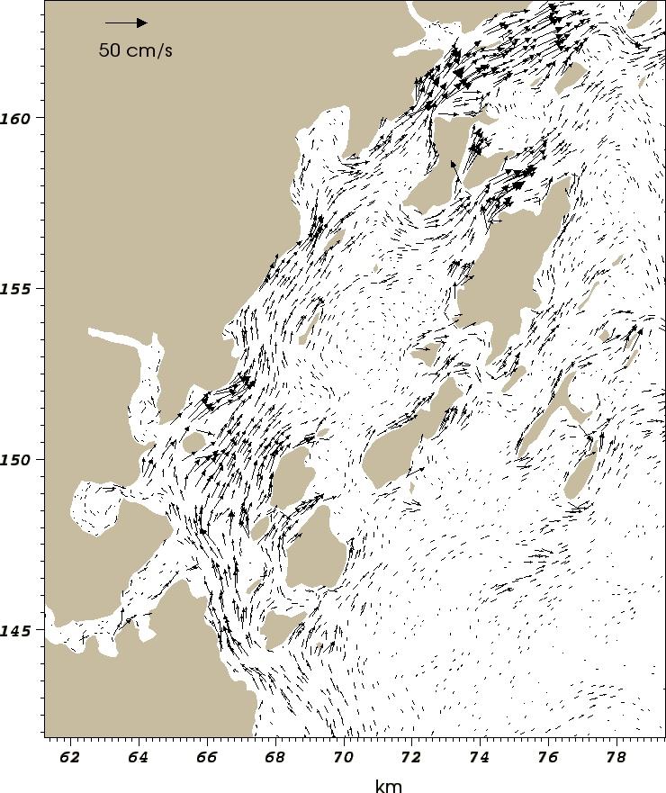
7 average surface elevation by 1.5 to 2 cm. As with the wind from the northeast, Figures 7a d illustrate the speed and direction of the wind driven current at the four depths of 1m, 10m, 25m, and 35m in a section east of Great Chebeague Island (see GC, Fig.1) out to the outer boundary south of Cape Small where the offshore waters enter the eastern half of the Bay. Again a counter flow is seen below 25 m, but the current exits the inner bay through Broad Sound at all depths. Overall, whether the wind is from the northeast or southwest, the major feature is a strong flow of about 30 cm/sec all along the shore from Cape Elizabeth to Maquoit Bay, along the west shore of both Maquoit Bay and Middle Bay, and along the east shore of Bailey Island. As mentioned earlier for this simulation, tidal and baroclinic forcing are not present. Also, fresh water intrusion from the Kennebec/Androscoggin River just east of Cape Small has not been included. The river discharge from the Kennebec/Androscoggin River in April and May can exceed 800 m3/sec. It is generally recognized (Kistner, 1999) that a low salinity plume from the Kennebec/Androscoggin River can enter Casco Bay south of Cape Small. A northeast on shelf wind would certainly enhance this flow, and possibly alter and freshen the surface waters that move into the bays and estuaries. Likewise, a southwest off shelf wind at Cape Small may be strong enough to push the Kennebec/Androscoggin discharge farther off shore to join the WMCC. 6. The Tide generated velocity field A separate run was created to examine the velocity field from the M2 tide only, the predominant tidal constituent in the Bay. The wind was turned off in this simulation. The triangular mesh for this study is embedded in a larger Gulf of Maine g2s.5b mesh (Lynch et al., 1993, and Naime et al., 1994). The g2s.5b mesh was used to create a set of bimonthly climatologies by Naimie et al.(1994). Since the emphasis of this study is on the Spring circulation, the model is initialized with tidal (M2 only) elevations interpolated at the open boundary from Naimie's May June bi monthly climatologies. During the model run, a timeseries was recorded for the tidal elevations at the Portland tide gauge and four subordinate tide locations whose harmonics are known. The M2 constituent was extracted from each timeseries using t tide(pawlowicz et al.,2002). The model predicted elevations slightly underestimated the M2 constituent at each location. The model predicted elevation at the Portland tide gauge was about 4 cm below the observed level, a percent error of 3%. At the other four locations, South Harpswell, Small Point, Cundy Harbor and Great Chebeague Island, the percent errors were 2.0, 2.8, 1.9, and 3.0 respectively. The vector field in Figures 8a,b show the vertically averaged flow three hours after the beginning of the flood tide for the western and eastern half of the Bay, respectively. The currents entering the Bay through the southwestern portion of the outer boundary are the sources for flooding Portland Harbor, Back Cove, and other coves and estuaries in the western part of the inner bay. These currents enter along the shoreline of Cape Elizabeth and through Hussey Sound, veer to the right and continue along the Falmouth/Yarmouth shoreline to the northern side of Cousins Island, where they converge with currents entering through Luckse and Broad Sounds. Consequently, the waters approaching the Royal River estuary may come from two sources. In Portland Channel, the vertically averaged currents at this stage of the flood tide are on the order of cm/sec. The surface drogues
8 used by Parker (1982) show surface currents in Portland Channel and Hussey Sound to be the highest that were measured in Casco Bay during that survey. During the middle two hours of flood tide, the surface drogues averaged cm/sec through Portland Channel, and cm/sec through Hussey Sound. The vertically averaged flow field during the third hour after ebb tide is shown in Figures 8c,d for the west and east halves of the inner bay, respectively. The water west of Cousins Island drains from the inner bay through Portland Channel and Hussey Sound with speeds in the cm/sec range. An equally strong current of lesser volume also flows through Chandler Cove (Chan Cove, Fig.1), where it meets with a southwesterly flow from Luckse Sound. After leaving the inner bay, the current from Portland Channel moves along the Cape Elizabeth shore and continues south to exit the computational domain. The flow out of Hussey Sound and Chandler Cove also move due south. On the eastern side of the Bay, the ebb flow out of the Royal River, Maquoit and Middle Bays moves into Luckse Sound and Broad Sound. The water from the Royal River outlet area flows east of Great Chebeague Island, where it continues along the island's south shore, enters Luckse Sound, and continues seaward in a southerly direction. Also, the flow out of Broad Sound continues seaward in a southerly direction. In summary, after leaving the inner bay through one of the major pathways, the outgoing tide moves across shelf to the outer boundary of the domain. Generally, the flood and ebb tidal currents follow the same direction with depth, with slower moving currents along the bottom. Although the presence of islands, shoals, and ledges all have an affect on producing small local eddies, vertical mixing and flow direction, there is no reverse flow at depth observed as with the wind driven currents. Sebascodegan Island (SI, Fig.1) is the largest island in Casco Bay, bounded by Harpswell Sound on the west and the New Meadows River estuary on the east. During the flood tide, the water entering through the eastern portion of the outer boundary south of Cape Small enters Harpswell Sound, Quahog Bay, and the New Meadows River estuary. The water that enters the New Meadows River estuary is just south of Cape Small and proceeds all the way around the north end of Sebascodegan Island through narrow channels and back down the west side toward Long Reach, where it meets the slower current moving up Harpswell Sound to fill the inner coves in this region. Likewise, on the ebb tide, there is flow leaving the Long Reach area south through Harpswell Sound and north to the New Meadows estuary. The area around Long Reach is one of the last areas to fully drain during the ebb tide. At any given time, the volume and speed of water flowing through the major pathways to the inner bay can be compared. Five vertical transects have been created across Portland Channel, Hussey Sound, Chandler Cove, Luckse Sound and Broad Sound, as shown by the solid black lines in Figure 2. The volume transports and mean speeds through each of these transects were computed at about 3.5 hours after the flood tide began, and again, 3.5 hours after the ebb tide began. The results are displayed in Table 1. It should be noted that the volume transports and mean speeds, by themselves, mean little, since the position, direction and length of each transect, and the time selected during the flooding and ebbing, can lead to considerable variation in the computations. The times selected are not necessarily the times in which the flow is at a maximum or minimum, hence the results in Table 1 are offered only as a comparison of volume transports and speeds at one instance in the tidal cycle.
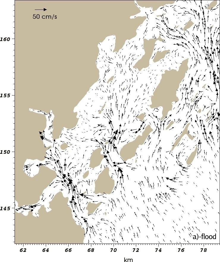
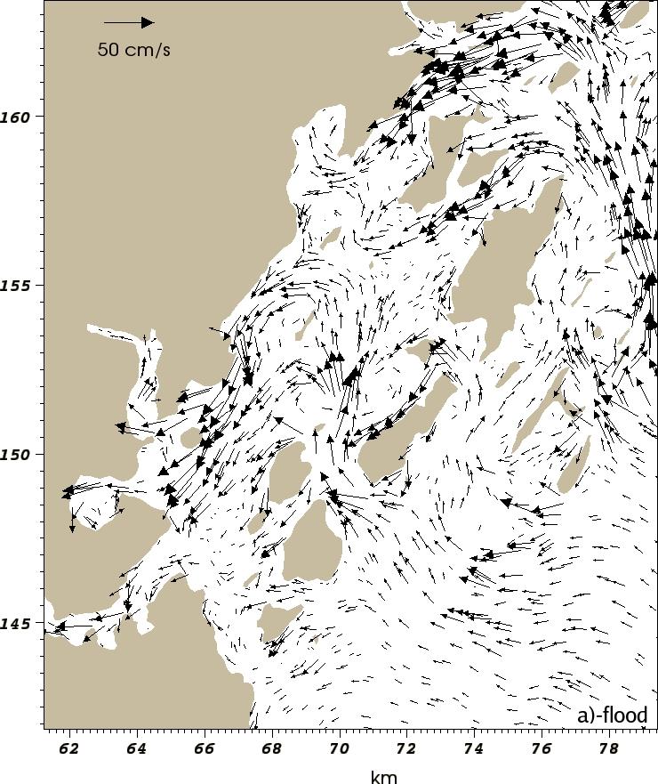
9 With regard to tidal flows only, the currents of Casco Bay might be viewed as having a western and eastern circulation, with minor volume exchanges around Great Chebeague Island and Cousins Island. Using the results in Table 1, the combined volume transport into the western part of the inner bay through Portland Channel, Hussey Sound and Chandler Cove is m3/sec, while the transport through Luckse Sound and Broad Sound to the eastern part of the inner bay is slightly more at m3/sec. Broad Sound is the deepest channel where colder, more saline water below 25 m can enter the inner bay. As seen from the wind generated currents, a wind from the southwest could establish an across shelf surface current offshore with a reverse bottom flow of colder, saltier, vertically mixed water moving into Maquoit and Middle Bay. Also, the tidal currents produce bottom currents through Broad Sound into the inner bays. 7. The Tide and Wind generated velocity field Anderson et al. (2005) observed high concentrations of Alexandrium fundyense along the western Maine coast after a northeaster during May 7 8 of These high concentrations were west of Casco Bay. McGillicuddy et al. (2005) refer to cells that germinate from cyst beds offshore from Penobscot and Casco Bays which are advected from east to west in the coastal current that lies just east of the computational domain of the mesh used in this study. The occurrences of A. fundyense blooms in Casco Bay may be initiated from local cyst beds or be advected from offshore during across shelf downwelling favorable winds from the northeast. The focus here is to determine how offshore cells might find their way into the coastal waters of the Bay, under conditions like those of May 7 8, To this end, another two day (4 tidal cycles) simulation was run, using the wind data from the GOMOOS buoy in Casco Bay for May 7 8 of 2005, along with the same May June tidal elevations used earlier. The hourly wind speed and direction for May 7 8, as shown in Figure 9, shows a fairly steady wind from the northeast for this period averaging 10.8 m/s, which sets up a westerly surface current onshore. The intrusion of Kennebec/Androscoggin River into the Bay is not present in this run. When the wind driven Ekman transports are superimposed on the tidal currents, the vertically integrated currents seaward of the islands in the deeper water move in a northwesterly direction toward shore during the flood tide, then rotate counterclockwise on the ebb flow and move in the southwesterly to southerly direction. As the next flood begins, the currents rotate clockwise and move northwesterly toward shore again. Compare this with the currents with tidal forcing only, as described earlier. When there is no wind, the velocity vectors in the outer bay experience a full counterclockwise rotation through one tidal cycle within their respective tidal ellipses. South of Cape Elizabeth, the current is always moving southwesterly both during the flooding and ebbing, suggesting that if A. fundyense do germinate within the Bay during these conditions, they could exit the Bay south of Cape Elizabeth and supplement the population in the WMCC. Throughout the inner bay, considerable complexities take place. The vertically integrated velocities for the western and eastern halves of Casco Bay during the flood and ebb tide are shown in Figures 10a d. South of Cape Small, the surface wind stress supplements the incoming tide. In Figure 10b, the current speeds and direction are shown about two hours into the flood tide. The water entering just south of Cape Small turns clockwise and flows
10 directly into the New Meadows River, while the flow entering the Bay about 8 km south of Cape Small moves into Harpswell Sound and Broad Sound. The flow through Broad Sound diverges with the east portion filling Maquoit and Middle Bays, but the western portion, influenced by the wind driven along shore flow, turns westerly around Great Chebeague Island and Cousins Island and joins the southwesterly current toward Portland Harbor. The wind driven current entering Portland Harbor encounters the incoming tidal flow and redirects the tidal flow to the east where it enters the inner bay through Hussey Sound and Chandler Cove. The volume transports for the same five channels that appeared in Table 1 are shown in Table 2. These transports correspond to the same times as the flooding and ebbing snapshots in Figures 10a d. Note the low transport in Portland Channel during the flood tide. Broad Sound is the only channel showing an increase in transport (compare with Table 1) when the northeast wind is included. However, on the ebb tide, there is a reduction in transport through Broad sound owing to the windward flow along the shore and exiting more through Portland Channel. The surface current through Portland Channel is on the order of 60 cm/s. Also, during the time following the start of the ebb tide, the sea level at the entrance to Portland Harbor is about 10 cm above that at the entrance to Maquoit Bay, as would be expected from the piling up of water from the westerly wind driven current along the Portland and South Portland shoreline. The direction and speed of the currents at the surface varies from that along the bottom. However, the complexities of the topography and island orientations do not allow for a general description of the variability. For example, during the flood tide, the surface currents south of Broad Sound, influenced by the wind from the northeast, flow in a westerly to northwesterly direction, while the bottom currents are flowing northerly into Broad Sound, bringing colder water in from offshore. Along the western shore of Portland Channel, the westerly surface current is piling up water onto the South Portland shore, while the bottom current is moving in the opposite direction offshore, establishing a local downwelling event. At the entrance to the New Meadows River estuary, there is a strong bottom current bringing offshore water into the estuary at speeds of 15 to 20 cm/s. With these wind and tidal conditions, the intrusions of A. fundyense into the eastern half of the Bay are possible at all depths. The waters entering the eastern half of the Bay from Cape Small to about 8 km south of Cape Small are the major sources for filling the regions such as the New Meadows River estuary, Quahog Bay, Lumbos Hole, and other bays and coves that have measured high concentrations of PSP. 8. The Kennebec/Androscoggin River influence During the Spring season, a fresh water surface layer exits the Kennebec/Androscoggin (henceforth called the Kennebec) River and enters the coastal waters just east of Cape Small. During the flood tide, this low salinity plume can flow west around Cape Small and into Casco Bay. This shallow mixed layer provides nutrients and trace metals that promote A. fundyense population growth (Anderson et al. 2005). Although Anderson (1997) indicates that no A. fundyense cells were found in the Kennebec River itself during a survey conducted by him and Keafer (1992), it is speculated that the Kennebec plume waters can serve as a pathway for cell entrance into eastern Casco Bay. To examine the influence of the Kennebec River spring discharge on the waters of eastern Casco Bay, a new grid
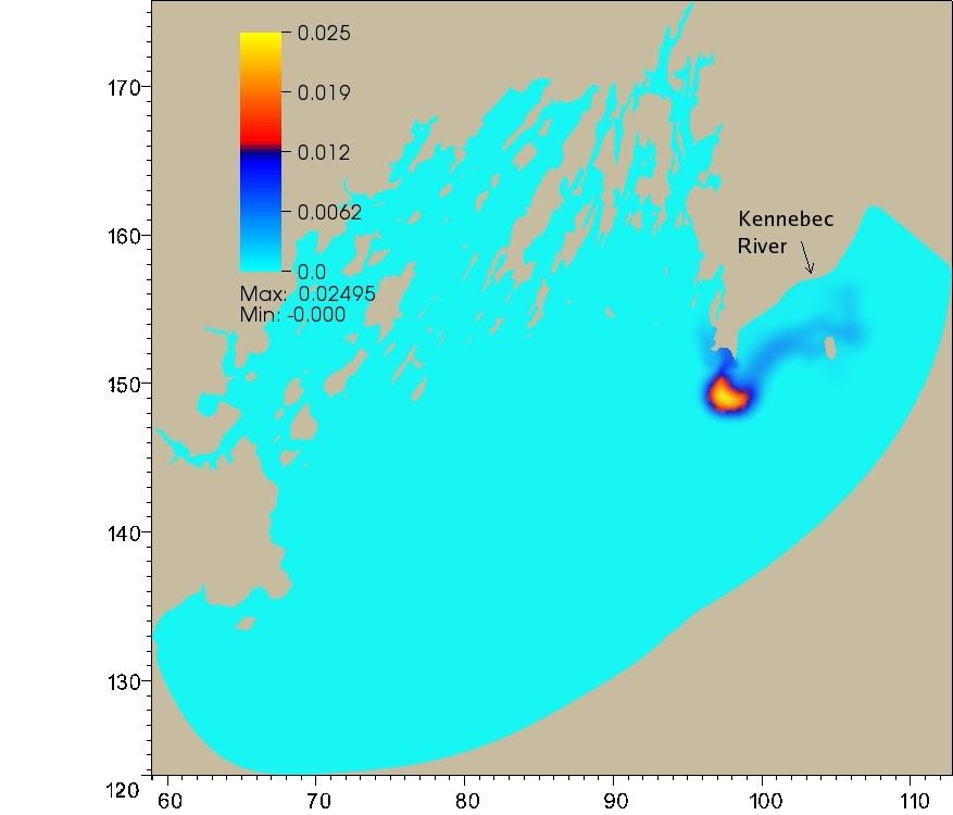
11 was created that extends the outer boundary of the previous grid to include the Kennebec River and surrounding shoreline. The spring volume discharge from the Kennebec River varies considerably, and is generally higher in March April than in May June. Lynch et al.(1997) prepared a table of Gulf of Maine river discharges that were averaged over the ten year period from In March April, the table shows an average discharge rate of 843 m3/s, and for May June it is 643 m3/s. For this simulation, a point source was added to the model at the mouth of the Kennebec River with a discharge value of 600 m3/s. The wind was turned off, and the May June tidal forcing for the newly created outer boundary was interpolated once again from the g2s.5b mesh. The FVCOM model provides for tracking a dye release, which was injected at the mouth of the river in the upper layer, and tracked for eight days. Since temperature and salinity measurements are not included in this preliminary study, this experiment is missing the density gradients and low salinity surface flow characteristics. Moreover, the model does not fully describe the tidal pumping within the Kennebec estuary itself. Nevertheless, the dye study does describe the tidally driven flow of the surface layer out of the river and its dispersion along the coast. The position of the dye pattern eight days after it was released from the mouth of the Kennebec River is shown in Figure 11. During the first four days, the plume stayed close to shore, but there is some low concentration dispersion away from the center of the dye patch. The currents along shore from the Kennebec River to the south of Cape Small are only about 5 8 cm/s, giving an average southwesterly dye patch speed of about 2.5 cm/s. During the next four days, the patch expands slightly to a width of approximately 4 km and a height of 3 km, and maintains its position at about 4 km south of Cape Small, with the center of the patch meandering within a 1 km radius in response to tidal reverses. The presence of this persistent low salinity surface layer patch was also observed in the data collected by Janzen et al. (2005), who recorded that there was little variance in its location from tides, winds or river discharge. The data collected by the Friends of Casco Bay also supports the intrusion of low density flow into the Bay around Cape Small. The salinity at FOCB stations 1, 2 and 3 was integrated over the upper 2m for the period and is shown in Figure 12. These are the three outermost stations with station 1 near Portland Channel, station 2 southeast of Broad Sound, and station 3 just south of Cape Small (see Figure 2). The salinity at Cape Small shows the lowest salinity values during the Spring freshet, no doubt reflecting the Kennebec plume flow into eastern Casco Bay during this period. In the absence of wind, the previous simulation suggests that a low salinity pool originates at the mouth of the Kennebec River, moves to a location about 4 km south of Cape Small, and tends to reside there until some external mechanism forces it to move or disperse. It was decided to create another simulation to see how the dye patch would respond to the wind events recorded by the GOMOOS buoy for May 7 14, This is the same wind data that was used previously for the tide and wind generated currents, but extended to eight days. Following the northeast winds, there is a change in wind direction which comes from the south to southwest for almost two days, starting around May10, but then generally comes from the northeast quadrant for the next few days. With the wind applied, the dye patch moves to a location about 1 km south of Cape Small within about 16 hours. It then continues to disperse throughout the entire eastern region of Casco Bay. Figure 11 shows the concentration of the patch after eight days, which envelopes Bailey Island, circulates around to the
12 western shore of Harpswell Neck, and enters the New Meadows River estuary. It is evident that, under downwelling favorable conditions, the Kennebec surface discharge can deliver plankton and nutrients to bays and coves in the eastern region of the Bay. 9. Conclusions A preliminary analysis of the currents of Casco Bay has been explored here. The presence of so many islands and a complex bottom topography leads to numerous localized circulations that can only be identified with a high resolution model like the one used here. The superposition of the wind driven component on the tidal forcing has a significant affect on transports and speeds within the inner Bay. Although numerous approaches and interpolation schemes have been applied to the available temperature and salinity data, the location and density of the data appears to be insufficient for inclusion in this study. If 30 40% of the across shelf current is non tidal as suggested by Janzen et al. (2005), a spatially complete temperature/salinity survey would be helpful for the computational domain used here to better understand baroclinic influences on the circulation in and around the islands and inner bays. In addition, when volume transports at Hussey Sound and Portland Channel become available from Janzen's ADCP instruments, comparisons will then be made with model transports to improve the model. The freshwater intrusion from the Kennebec/Androscoggin River surface layer into the eastern portion of the Bay alters the water type in nearby bays and coves, and serves as a conveyance for plankton and nutrients from offshore. The surface plume from the river discharge will be understood and tracked better when temperature and salinity are included in the model to incorporate density gradients in the model dynamics. A number of scenarios also need to be explored based on the location of the Western Maine Coastal Current just outside Casco Bay, and the exchange between these waters and the Bay.
13 Figure Captions Fig. 1. Casco Bay, showing the mainland, islands, the 15 m isobath (dotted line), location of Portland Channel, Hussey, Luckse and Broad sounds, the outer boundary of the study area, and important land marks. Fig. 2. Locations of data available from FOCB, NODC, and NOAA and GOMOOS buoys. Solid black lines indicate locations of vertical transects across Portland Channel, Chandler Cove, Hussey, Luckse and Broad Sound. Fig. 3. Hourly time series of sea level at the Portland tide gauge for May Fig. 4. Vertically integrated velocities with winds from the northeast. Top: western and eastern halves of the Bay. Bottom left: Circulation in Maquoit and Middle Bays; right: eddies west of Cape Small. Fig. 5. Northeasterly wind generated velocities southeast of Broad Sound at four depths. Top left: 1 m, top right: 10 m, bottom left, 25 m, bottom right 35 m. Fig. 6. Southwesterly wind generated vertically integrated velocities. Left: western half and right: eastern half of the Bay. Fig. 7. Velocities southeast of Broad Sound at four depths due to winds from the southwest. Top left: 1 m, top right: 10 m, bottom left, 25 m, bottom right 35 m. Fig. 8. Tide generated vertically integrated velocities. Top: flood tide in western and eastern halves of the Bay. Bottom: ebb tide in western and eastern halves of the Bay. Fig. 9. Hourly wind speeds and directions during the northeaster of May 7 9, Fig. 10. Tide and wind generated vertically integrated velocities. Top: flood tide in western and eastern halves of the Bay. Bottom: ebb tide in western and eastern halves of the Bay. Fig. 11. Left: Dye patch after eight days with tide only. Right: Dye patch after eight days with tide and wind. Fig. 12. Integrated salinity at FOCB stations 1, 2 and 3, shown from top to bottom. The salinity near Cape Small (station 3) is considerably lower in May than at the other two stations. Table 1. Volume transports and mean speeds of the tide generated currents at transects across five pathways to the inner bay. Table 2. Volume transports and mean speeds of the tide and wind generated currents at transects across five pathways to the inner bay.
14 Transect Transect Area (m2) Transport(m3/sec ), mean_speed(cm/s) Flood Ebb Portland Channel , , 21 Hussey Sound , , 35 Chandler Cove , , 27 Luckse Sound , , 16 Broad Sound , , 23 Table 1. Volume transports and mean speeds of the tide generated currents at transects across five pathways to the inner bay. Transect Transect Area (m2) Transport(m3/sec ), mean_speed(cm/s) Flood Ebb Portland Channel , , 30 Hussey Sound , , 35 Chandler Cove , , 24 Luckse Sound , , 20 Broad Sound , ,19 Table 2. Volume transports and mean speeds of the tide and wind generated currents at transects across five pathways to the inner bay.
15 Figure 1.
16 Figure 2.
17 Figure 3.


18 Figure 4.

19 Figure 5.

20 Figure 6.

21 Figure 7.


22 Figure 8.
23 Figure 9.


24 Figure 10.

25 Figure 11.
26 Figure 12.
27 References Anderson, D.M., Keafer, B.A., McGillicuddy, D.J., Mickelson, M.J., Keay, K.E., Libby, P.S., Manning, J.P., Mayo, C.A., Whittaker, D.K., Hickey, J.M., He, R., Lynch, D.R., Smith, K.W., Initial observations of the 2005 Alexandrium fundyense bloom in southern New England: General patterns and mechanisms. Deep Sea Research II 52 (2005) Anderson, D.M., Diversity of harmful algal blooms in coastal waters. Limnol. Oceanogr.,42, (1997), Anderson, D.M., Keafer, B.A., Paralytic shellfish poisoning on Geaorges Bank: in situ growth or advection of established dinoflagellate populations? p In Proc. Gulf of Maine Sci. Workshop. Urban Harbors Inst. CBEP, Casco Bay Estuary Partnership, USM Muskie School, PO Box 9300, 49 Exeter St., Portland, ME Chen, C., Liu, H., Beardsley, R., An unstructured grid, finite volume, three dimensional, primitive equations ocean model: Application to coastal ocean and estuaries. Journal of Atmospheric and Ocean Technology, 20(1), Doucette, G.J., Turner, J.T., Powell, C.L., Keafer, B.A., Anderson,D.M., Trophic accumulation of PSP toxins in zooplankton during Alexandrium fundyense blooms in Casco Bay, Gulf of Maine, April June, I. Toxin levels in A. fundyense and zooplankton size fractions. Deep Sea Research II 52 (2005) DMR 2006, Department of Marine Resources, 21 State House Station Augusta, ME FOCB, 43 Slocum Drive, South Portland, ME Geyer, W.R., Signell R.P., Fong, D.A., Wand, J., Anderson, D.M., Keafer, B.A The freshwater transport and dynamics of the western Maine coastal current. Continental Shelf Research Keafer, B.A., Churchill, J.H., McGillicuddy, D.J., Anderson, D.M., Bloom development and transport of toxic Alexandrium fundyense populations within a coastal plume in the Gulf of Maine. Deep Sea Research II 52 (19 21), Kistner, D.A., Pettigrew, N.R.,1999. Reverse estuarine circulation in the New Meadows Estuary, Maine. (Abstract), American Spring Meeting, Boston, MA In: EOS, Transactions, American Geophysical Union 79(1), OS61 Janzen, C. D., Churchill, J. H., Pettigrew, N. R., Observations of exchange between eastern Casco Bay and the western Gulf of Maine. Deep Sea Research II 52 (2005) Lynch, D.R., Naimie, C.E., The M2 Tide and Its Residual on the Outer Banks of the Gulf of Maine. Journal of Physical Oceanography, 23, Lynch, D.R., Holboke,M.J., Naimie,C.E., The Maine coastal current: spring climatological circulation. Continental Shelf Research 17, (6),
28 McGillicudy, D.J., Anderson, D.M., Lynch, D.R., Townsend, D.W., Mechanisms regulating the large scale seasonal fluctuations in Alexandrium fundyense populations in the Gulf of Maine: results from a physical biological model. Deep Sea Research II 52, Mellor, G. L., Yamada, T., Development of a turbulence closure model for geophysical fluid problems. Reviews Geophysics Space Physics 20, Naimie, C.E., Loder, J.W., Lynch, D.R., Seasonal variation of the three dimensional residual circulation on Georges Bank. Journal of Geophysical Research, vol 99, no. C8, Pawlowicz, R., Beardsley, B., Lentz, S., Classical tidal harmonic analysis including error estimates in MATLAB using T TIDE. Computers and Geosciences 28, Parker, C.E., The currents of Casco Bay and the prediction of oil spill trajectories. Technical Report No. 28, Bigelow Laboratory for Ocean Sciences, West Boothbay Harbor, ME Shewchuck, J. R. Triangle. Smagorinsky, J General circulation experiments with the primitive equations. Monthly Weather Reviews 91, Smith, K. W., Bilgli, Ata, BATTRI 2 D Triangular Grid Generator. nml.dartmouth.edu/software/battri Turner, J.T., Doucette, G.J., Keafer, B.A., Anderson,D.M., Trophic accumulation of PSP toxins in zooplankton during Alexandrium fundyense blooms in Casco Bay, Gulf of Maine, April June, II. Toxin levels in A. fundyense and zooplankton size fractions. Deep Sea Research II 52 (2005) USGS. U.S. Geological Survey Open File Report , Surficial Sediment Data from the Gulf of Maine, Georges Bank, and Vicinity: a GIS compilation. < 001/maps/cascobay.htm> Westerman, David, Geology Dept., Norwich University, Northfield, VT., personal communication.
Red Tide Blooms in Casco Bay (2010 State of the Bay Presentation)
") University of Southern Maine USM Digital Commons Presentations Casco Bay Estuary Partnership (CBEP) 2010 Red Tide Blooms in Casco Bay (2010 State of the Bay Presentation) Scott Libby Battelle Don Anderson
University of Southern Maine USM Digital Commons Presentations Casco Bay Estuary Partnership (CBEP) 2010 Red Tide Blooms in Casco Bay (2010 State of the Bay Presentation) Scott Libby Battelle Don Anderson
THE RESPONSE OF THE GULF OF MAINE COASTAL CURRENT SYSTEM TO LATE-SPRING
 THE RESPONSE OF THE GULF OF MAINE COASTAL CURRENT SYSTEM TO LATE-SPRING NORTHEASTERLY WIND FORCING Neal R Pettigrew and Huijie Xue School of Marine Sciences University of Maine, Orono ME 04469 The Gulf
Currents measurements in the coast of Montevideo, Uruguay
 Currents measurements in the coast of Montevideo, Uruguay M. Fossati, D. Bellón, E. Lorenzo & I. Piedra-Cueva Fluid Mechanics and Environmental Engineering Institute (IMFIA), School of Engineering, Research
Training program on Modelling: A Case study Hydro-dynamic Model of Zanzibar channel
 Training program on Modelling: A Case study Hydro-dynamic Model of Zanzibar channel Mayorga-Adame,C.G., Sanga,I.P.L., Majuto, C., Makame, M.A., Garu,M. INTRODUCTION Hydrodynamic Modeling In understanding
Geostrophic and Tidal Currents in the South China Sea, Area III: West Philippines
 Southeast Asian Fisheries Development Center Geostrophic and Tidal Currents in the South China Sea, Area III: West Philippines Anond Snidvongs Department od Marine Science, Chulalongkorn University, Bangkok
Exploring Localized Mixing Dynamics During Wet Weather in a Tidal Fresh Water System
 Exploring Localized Mixing Dynamics During Wet Weather in a Tidal Fresh Water System Ramona McCullough & Phil Duzinski Delaware Estuary Science & Environmental Summit January 27, 2015 Background and objectives
Red Tide Surveys of Massachusetts Bay, 1999
 Red Tide Surveys of Massachusetts Bay, 1999 Massachusetts Water Resources Authority Environmental Quality Department Report ENQUAD 2000-17 FINAL REPORT Red Tide Surveys of Massachusetts Bay, 1999 by D.
Three-dimensional High-resolution Numerical Study of the Tide and Tidal Current in the Jiaozhou Bay and Olympic Sailing Site
 Three-dimensional High-resolution Numerical Study of the Tide and Tidal Current in the Jiaozhou Bay and Olympic Sailing Site By Jinrui Chen Ocean University of China cooperator: Shiliang Shan, Huaming
Section 6. The Surface Circulation of the Ocean. What Do You See? Think About It. Investigate. Learning Outcomes
 Chapter 5 Winds, Oceans, Weather, and Climate Section 6 The Surface Circulation of the Ocean What Do You See? Learning Outcomes In this section, you will Understand the general paths of surface ocean currents.
Lesson: Ocean Circulation
 Lesson: Ocean Circulation By Keith Meldahl Corresponding to Chapter 9: Ocean Circulation As this figure shows, there is a connection between the prevailing easterly and westerly winds (discussed in Chapter
Tidal regime along Vietnam coast under impacts of sea level rise
 VNU Journal of Science, Earth Sciences 28 (2012) 133-139 Tidal regime along Vietnam coast under impacts of sea level rise Tran Thuc, Duong Hong Son* Vietnam Institute of Meteorology, Hydrology and Environment
Wednesday, September 27, 2017 Test Monday, about half-way through grading. No D2L Assessment this week, watch for one next week
 Wednesday, September 27, 2017 Test Monday, about half-way through grading No D2L Assessment this week, watch for one next week Homework 3 Climate Variability (due Monday, October 9) Quick comment on Coriolis
Ocean Circulation. Si Hui Lee and Frances Wen. You can access ME at
 Ocean Circulation Si Hui Lee and Frances Wen You can access ME at http://tinyurl.com/oceancirculation Earth - the blue planet - 71% area covered by the oceans - 3/4 of ocean area between 3000-6000m deep
Tidal flushing and eddy shedding in Mount Hope Bay and Narragansett Bay: An application of FVCOM
 Click Here for Full Article JOURNAL OF GEOPHYSICAL RESEARCH, VOL. 111,, doi:10.1029/2005jc003135, 2006 Tidal flushing and eddy shedding in Mount Hope Bay and Narragansett Bay: An application of FVCOM Liuzhi
The Impact on Great South Bay of the Breach at Old Inlet Charles N. Flagg School of Marine and Atmospheric Sciences, Stony Brook University
 The Impact on Great South Bay of the Breach at Old Inlet Charles N. Flagg School of Marine and Atmospheric Sciences, Stony Brook University The previous report provided a detailed look at the conditions
Request Number IR1-12: Flow Passage. Information Request
 Request Number IR1-12: Flow Passage Information Request Provide additional information about the 100 metre flow passage channel scenario between the Westshore Terminals and the proposed Project terminal
CHAPTER 134 INTRODUCTION
 CHAPTER 134 NEW JETTIES FOR TUNG-KANG FISHING HARBOR, TAIWAN Chi-Fu Su Manager Engineering Department Taiwan Fisheries Consultants, Inc. Taipei, Taiwan INTRODUCTION Tung-Kang Fishing Harbor, which is about
Figure 4, Photo mosaic taken on February 14 about an hour before sunset near low tide.
 The Impact on Great South Bay of the Breach at Old Inlet Charles N. Flagg and Roger Flood School of Marine and Atmospheric Sciences, Stony Brook University Since the last report was issued on January 31
Structure and discharge test cases
 Chapter 28 Structure and discharge test cases 28.1 Introduction Three test case have been implemented to test the performance and applicability of the structures and discharges modules. drythin Simulates
Ocean Currents Unit (4 pts)
") Name: Section: Ocean Currents Unit (Topic 9A-1) page 1 Ocean Currents Unit (4 pts) Ocean Currents An ocean current is like a river in the ocean: water is flowing traveling from place to place. Historically,
Name: Section: Ocean Currents Unit (Topic 9A-1) page 1 Ocean Currents Unit (4 pts) Ocean Currents An ocean current is like a river in the ocean: water is flowing traveling from place to place. Historically,
Effect of Hydrodynamics on Sediment Transport near a Coastal Inlet
 ICHE 2014, Hamburg - Lehfeldt & Kopmann (eds) - 2014 Bundesanstalt für Wasserbau ISBN 978-3-939230-32-8 Effect of Hydrodynamics on Sediment Transport near a Coastal Inlet H. Li, M. Brown, J. Rosati & Z.
Water circulation in Dabob Bay, Washington: Focus on the exchange flows during the diurnal tide transitions
 Water circulation in Dabob Bay, Washington: Focus on the exchange flows during the diurnal tide transitions Jeong-in Kang School of Oceanography University of Washington (206) 349-7319 nortiumz@u.washington.edu
Appendix 5: Currents in Minas Basin. (Oceans Ltd. 2009)
") Appendix 5: Currents in Minas Basin (Oceans Ltd. 29) Current in Minas Basin May 1, 28 March 29, 29 Submitted To: Minas Basin Pulp and Power P.O. Box 41 53 Prince Street Hansport, NS, BP 1P by 22, Purdy
Appendix 5: Currents in Minas Basin (Oceans Ltd. 29) Current in Minas Basin May 1, 28 March 29, 29 Submitted To: Minas Basin Pulp and Power P.O. Box 41 53 Prince Street Hansport, NS, BP 1P by 22, Purdy
Alongshore wind stress (out of the page) Kawase/Ocean 420/Winter 2006 Upwelling 1. Coastal upwelling circulation
 Kawase/Ocean 420/Winter 2006 Upwelling 1. Coastal upwelling circulation") Kawase/Ocean 420/Winter 2006 Upwelling 1 Coastal upwelling circulation We found that in the northern hemisphere, the transport in the surface Ekman layer is to the right of the wind. At the bottom, there
Kawase/Ocean 420/Winter 2006 Upwelling 1 Coastal upwelling circulation We found that in the northern hemisphere, the transport in the surface Ekman layer is to the right of the wind. At the bottom, there
DUXBURY WAVE MODELING STUDY
 DUXBURY WAVE MODELING STUDY 2008 Status Report Duncan M. FitzGerald Peter S. Rosen Boston University Northeaster University Boston, MA 02215 Boston, MA 02115 Submitted to: DUXBURY BEACH RESERVATION November
Chapter 10 Lecture Outline. The Restless Oceans
 Chapter 10 Lecture Outline The Restless Oceans Focus Question 10.1 How does the Coriolis effect influence ocean currents? The Ocean s Surface Circulation Ocean currents Masses of water that flow from one
Winds and Ocean Circulations
 Winds and Ocean Circulations AT 351 Lab 5 February 20, 2008 Sea Surface Temperatures 1 Temperature Structure of the Ocean Ocean Currents 2 What causes ocean circulation? The direction of most ocean currents
AIRFLOW GENERATION IN A TUNNEL USING A SACCARDO VENTILATION SYSTEM AGAINST THE BUOYANCY EFFECT PRODUCED BY A FIRE
 - 247 - AIRFLOW GENERATION IN A TUNNEL USING A SACCARDO VENTILATION SYSTEM AGAINST THE BUOYANCY EFFECT PRODUCED BY A FIRE J D Castro a, C W Pope a and R D Matthews b a Mott MacDonald Ltd, St Anne House,
CROSS-SHORE SEDIMENT PROCESSES
 The University of the West Indies Organization of American States PROFESSIONAL DEVELOPMENT PROGRAMME: COASTAL INFRASTRUCTURE DESIGN, CONSTRUCTION AND MAINTENANCE A COURSE IN COASTAL DEFENSE SYSTEMS I CHAPTER
Undertow - Zonation of Flow in Broken Wave Bores
 Nearshore Circulation Undertow and Rip Cells Undertow - Zonation of Flow in Broken Wave Bores In the wave breaking process, the landward transfer of water, associated with bore and surface roller decay
ABSTRACT. KEY WORDS: Navigation safety; numerical modeling; waves; current; sediment transport; channel infilling; morphology change.
 The 25th (2015) International Polar and Engineering Conference Li, H., L. Lin, Z. Demirbilek, T. M. Beck, and H. R. Moritz (2015). Wave-Current Conditions and Navigation Safety at an Inlet Entrance. The
CHAPTER 7 Ocean Circulation
 1 2 3 4 5 6 7 8 9 10 11 12 13 14 CHAPTER 7 Ocean Circulation Words Ocean currents Moving seawater Surface ocean currents Transfer heat from warmer to cooler areas Similar to pattern of major wind belts
EARTH, PLANETARY, & SPACE SCIENCES 15 INTRODUCTION TO OCEANOGRAPHY. LABORATORY SESSION #6 Fall Ocean Circulation
 EARTH, PLANETARY, & SPACE SCIENCES 15 INTRODUCTION TO OCEANOGRAPHY LABORATORY SESSION #6 Fall 2017 Ocean Circulation The focus of the Lab this week is circulation of the ocean and atmosphere. Here, you
The Various Components of the Circulation in the Singapore Strait Region: Tidal, Wind and Eddy-driven Circulations and Their Relative Importance
 The Various Components of the Circulation in the Singapore Strait Region: Tidal, Wind and Eddy-driven Circulations and Their Relative Importance Haoliang Chen CENSAM, Singapore-MIT Alliance for Research
SURFACE CURRENTS AND TIDES
 NAME SURFACE CURRENTS AND TIDES I. Origin of surface currents Surface currents arise due to the interaction of the prevailing wis a the ocean surface. Hence the surface wi pattern (Figure 1) plays a key
Monday, October 2, Watch for new assessment (Week 4/5 review) TA s have your tests, please see key (at course website)
 TA s have your tests, please see key (at course website)") Monday, October 2, 2017 Watch for new assessment (Week 4/5 review) TA s have your tests, please see key (at course website) Homework 3 Due date Wednesday, Oct 11 (8 pm) Be ready to watch another important
Monday, October 2, 2017 Watch for new assessment (Week 4/5 review) TA s have your tests, please see key (at course website) Homework 3 Due date Wednesday, Oct 11 (8 pm) Be ready to watch another important
Modelling study of the dispersal of pollutants at SHo Jacinto submarine outfall (Aveiro, Portugal)
") Modelling study of the dispersal of pollutants at SHo Jacinto submarine outfall (Aveiro, Portugal) M. Ramosl, M. Almeidal, P. Silval, J. Dubertl & J. Antunes do Carrno2 l Department of Physics, University
Modelling study of the dispersal of pollutants at SHo Jacinto submarine outfall (Aveiro, Portugal) M. Ramosl, M. Almeidal, P. Silval, J. Dubertl & J. Antunes do Carrno2 l Department of Physics, University
Undertow - Zonation of Flow in Broken Wave Bores
 Lecture 22 Nearshore Circulation Undertow - Zonation of Flow in Broken Wave Bores In the wave breaking process, the landward transfer of water, associated with bore and surface roller decay within the
Chapter 11 Tides. A tidal bore is formed when a tide arrives to an enclosed river mouth. This is a forced wave that breaks.
 Chapter 11 Tides A tidal bore is formed when a tide arrives to an enclosed river mouth. This is a forced wave that breaks. Tidal range can be very large Tide - rhythmic oscillation of the ocean surface
An Investigation of the Influence of Waves on Sediment Processes in Skagit Bay
 DISTRIBUTION STATEMENT A. Approved for public release; distribution is unlimited. An Investigation of the Influence of Waves on Sediment Processes in Skagit Bay Geoffrey W. Cowles School for Marine Science
Figure 1 Location of the ANDRILL SMS 2006 mooring site labeled ADCP1 above.
 ANDRILL McMurdo Sound Tidal Current Analysis Richard Limeburner, Robert Beardsley and Sean Whelan Department of Physical Oceanography Woods Hole Oceanographic Institution Woods Hole, MA 02543 rlimeburner@whoi.edu
Chapter 22, Section 1 - Ocean Currents. Section Objectives
 Chapter 22, Section 1 - Ocean Currents Section Objectives Intro Surface Currents Factors Affecting Ocean Currents Global Wind Belts (you should draw and label a diagram of the global wind belts) The Coriolis
Simulation of hydraulic regime and sediment transport in the Mekong delta coast
 Simulation of hydraulic regime and sediment transport in the Mekong delta coast 1. Introduction Coastal erosion in the Mekong Delta has been recorded in recent years and the erosion rate has been increasing
8.4 COASTAL WIND ANOMALIES AND THEIR IMPACT ON SURFACE FLUXES AND PROCESSES OVER THE EASTERN PACIFIC DURING SUMMER
 8.4 COASTAL WIND ANOMALIES AND THEIR IMPACT ON SURFACE FLUXES AND PROCESSES OVER THE EASTERN PACIFIC DURING SUMMER Ragoth Sundararajan * and Darko Koraĉin Desert Research Institute, Reno, NV, USA Michael
Yellow Sea with contributions by John R. Apel
 with contributions by John R. Apel Overview The is a shallow inland sea lying between northeastern China and the Korean Peninsula, with depths in its central north-south trough in excess of 60 to 80 m
The ocean water is dynamic. Its physical
 CHAPTER MOVEMENTS OF OCEAN WATER The ocean water is dynamic. Its physical characteristics like temperature, salinity, density and the external forces like of the sun, moon and the winds influence the movement
INTRODUCTION * Corresponding author address: Michael Tjernström, Stockholm University, Department of Meteorology, SE-
 4.12 NEW ENGLAND COASTAL BOUNDARY LAYER MODELING Mark Žagar and Michael Tjernström * Stockholm University, Stockholm, Sweden Wayne Angevine CIRES, University of Colorado, and NOAA Aeronomy Laboratory,
from a decade of CCD temperature data
 (Some of) What we have learned from a decade of CCD temperature data Craig Gelpi and Karen Norris Long Beach Aquarium of the Pacific August 15, 2008 Introduction Catalina Conservancy Divers collected temperature
The Influence of Wind Direction upon Flow along the West Coast of Britain and in the North Channel of the Irish Sea
 JANUARY 2003 DAVIES AND XING 57 The Influence of Wind Direction upon Flow along the West Coast of Britain and in the North Channel of the Irish Sea ALAN M. DAVIES AND JIUXING XING Proudman Oceanographic
Temperature, Salinity, Dissolved Oxygen and Water Masses of Vietnamese Waters
 Southeast Asian Fisheries Development Center Temperature, Salinity, Dissolved Oxygen and Water Masses of Vietnamese Waters Penjan Rojana-anawat, Siriporn Pradit, Natinee Sukramongkol and Somboon Siriraksophon
Impact of the tides, wind and shelf circulation on the Gironde river plume dynamics
 Impact of the tides, wind and shelf circulation on the Gironde river plume dynamics F. Toublanc 1, N. Ayoub 2, P. Marsaleix 3, P. De Mey 2 1 CNES/LEGOS 2 CNRS/LEGOS 3 CNRS/LA, Toulouse, France 5th GODAE
Impact of Dredging the Lower Narrow River on Circulation and Flushing
 Impact of Dredging the Lower Narrow River on Circulation and Flushing Craig Swanson Ph.D. Swanson Environmental Alex Shaw Ocean Engineering, URI Prof. Malcolm L. Spaulding Ocean Engineering, URI 29 January
6.28 PREDICTION OF FOG EPISODES AT THE AIRPORT OF MADRID- BARAJAS USING DIFFERENT MODELING APPROACHES
 6.28 PREDICTION OF FOG EPISODES AT THE AIRPORT OF MADRID- BARAJAS USING DIFFERENT MODELING APPROACHES Cecilia Soriano 1, Darío Cano 2, Enric Terradellas 3 and Bill Physick 4 1 Universitat Politècnica de
THE CIRCULATION IN THE NORTERN PART OF THE DENMARK STRAIT AND ITS VARIABILITY ABSTRACT
 ICES em 19991L:06 THE CIRCULATION IN THE NORTERN PART OF THE DENMARK STRAIT AND ITS VARIABILITY Steingrimur J6nsson Marine Research Institute and University of Akureyri, Glenirgata 36, 600 Akureyri, Iceland,
The Impact on Great South Bay of the Breach at Old Inlet Charles N. Flagg School of Marine and Atmospheric Sciences, Stony Brook University
 The Impact on Great South Bay of the Breach at Old Inlet Charles N. Flagg School of Marine and Atmospheric Sciences, Stony Brook University This is the sixth in a series of reports describing the evolution
10% water in the world is tied up in the surface ocean currents. (above the pycnocline) Primary source is wind: Westerlies, Trades, Polar Easterlies
 Primary source is wind: Westerlies, Trades, Polar Easterlies") Oceanography Chapter 9 10% water in the world is tied up in the surface ocean currents. (above the pycnocline) Primary source is wind: Westerlies, Trades, Polar Easterlies Coriolis deflects winds (and
Oceanography Chapter 9 10% water in the world is tied up in the surface ocean currents. (above the pycnocline) Primary source is wind: Westerlies, Trades, Polar Easterlies Coriolis deflects winds (and
Inlet Management Study for Pass-A-Grille and Bunces Pass, Pinellas County, Florida
 Inlet Management Study for Pass-A-Grille and Bunces Pass, Pinellas County, Florida Final Report Submitted By Ping Wang, Ph.D., Jun Cheng Ph.D., Zachary Westfall, and Mathieu Vallee Coastal Research Laboratory
Shorelines Earth - Chapter 20 Stan Hatfield Southwestern Illinois College
 Shorelines Earth - Chapter 20 Stan Hatfield Southwestern Illinois College The Shoreline A Dynamic Interface The shoreline is a dynamic interface (common boundary) among air, land, and the ocean. The shoreline
EFFECTS OF WAVE, TIDAL CURRENT AND OCEAN CURRENT COEXISTENCE ON THE WAVE AND CURRENT PREDICTIONS IN THE TSUGARU STRAIT
 EFFECTS OF WAVE, TIDAL CURRENT AND OCEAN CURRENT COEXISTENCE ON THE WAVE AND CURRENT PREDICTIONS IN THE TSUGARU STRAIT Ayumi Saruwatari 1, Yoshihiro Yoneko 2 and Yu Tajima 3 The Tsugaru Strait between
Fine-Scale Survey of Right and Humpback Whale Prey Abundance and Distribution
 DISTRIBUTION STATEMENT A. Approved for public release; distribution is unlimited. Fine-Scale Survey of Right and Humpback Whale Prey Abundance and Distribution Joseph D. Warren School of Marine and Atmospheric
Modeling changes to the historic Lower Columbia River Estuary using Delft3D. Drew Mahedy Lumas Helaire Stefan Talke David Jay May 30, 2014
 Modeling changes to the historic Lower Columbia River Estuary using Delft3D Drew Mahedy Lumas Helaire Stefan Talke David Jay May 30, 2014 Comparison: Historic and Modern LCRE US Coastal Survey, 1868 Historic
Role of the oceans in the climate system
 Role of the oceans in the climate system heat exchange and transport hydrological cycle and air-sea exchange of moisture wind, currents, and upwelling gas exchange and carbon cycle Heat transport Two Primary
Casco Bay Intensified PSP Sampling Project
 Casco Bay Intensified PSP Sampling Project conducted by MER Corp. in cooperation with the Maine DMR with funding from the Casco Bay Estuary Partnership October 16, 2006 Problems: 1. Limited number of routine
DUE TO EXTERNAL FORCES
 17B.6 DNS ON GROWTH OF A VERTICAL VORTEX IN CONVECTION DUE TO EXTERNAL FORCES Ryota Iijima* and Tetsuro Tamura Tokyo Institute of Technology, Yokohama, Japan 1. INTRODUCTION Various types of vertical vortices,
Computational Analysis of Oil Spill in Shallow Water due to Wave and Tidal Motion Madhu Agrawal Durai Dakshinamoorthy
 Computational Analysis of Oil Spill in Shallow Water due to Wave and Tidal Motion Madhu Agrawal Durai Dakshinamoorthy 1 OUTLINE Overview of Oil Spill & its Impact Technical Challenges for Modeling Review
Tidally influenced environments. By Alex Tkaczyk, Henrique Menezes, and Isaac Foli
 Tidally influenced environments By Alex Tkaczyk, Henrique Menezes, and Isaac Foli Goals and aims Describe the role of tidal influence in depositional environments. - Deltas - Estuaries Provide an overview
JOURNAL OF GEOPHYSICAL RESEARCH, VOL. 107, NO. C9, 3123, doi: /2000jc000768, 2002
 JOURNAL OF GEOPHYSICAL RESEARCH, VOL. 107, NO. C9, 3123, doi:10.1029/2000jc000768, 2002 A modeling study of shelf circulation off northern California in the region of the Coastal Ocean Dynamics Experiment:
A NUMERICAL STUDY OF EXCHANGE AND MIXING OVER A SILL AT THE MOUTH OF THE SAINT JOHN RIVER ESTUARY
 2 nd CSCE Specialty Conference on Coastal, Estuary and Offshore Engineering 2 e Conférence spécialisée sur le génie côtier, des estuaires et de l'offshore Toronto, Ontario, Canada June 2-4, 2005 / 2-4
Modeling 3D circulation in the Choctawhatchee Bay and River System
 Modeling 3D circulation in the Choctawhatchee Bay and River System Rosemary Cyriac 1, Casey Dietrich 1, Arash Fathi 2, Clint Dawson 2, Kendra Dresback 3, Cheryl Ann Blain 4, Matthew Bilskie 5, Scott Hagen
Current mooring observations in the area of the South Kuril Islands
 Current mooring observations in the area of the South Kuril Islands Georgy Shevchenko, Gennady Kantakov 2* and Valery Chastikov 2 Institute of Marine Geology and Geophysics FEB RAS, Yuzhno-Sakhalinsk,
The Continuing Evolution of the New Inlet
 The Continuing Evolution of the New Inlet Charles N. Flagg, Roger Flood and Robert Wilson School of Marine and Atmospheric Sciences, Stony Brook University It is now a year plus since super storm Sandy
JOURNAL OF GEOPHYSICAL RESEARCH, VOL. 107, NO. C11, 3184, doi: /2001jc001190, 2002
 JOURNAL OF GEOPHYSICAL RESEARCH, VOL. 107, NO. C11, 3184, doi:10.1029/2001jc001190, 2002 A modeling study of shelf circulation off northern California in the region of the Coastal Ocean Dynamics Experiment
Modeling Results for Glacier Bay
 Chapter 9 Modeling Results for Glacier Bay Finally, attention is now turned to a number of specific results of interest for the Glacier Bay domain. 9.1 Water Surface Elevation In the previous chapter,
Variability of surface transport in the Northern Adriatic Sea from Finite-Size Lyapunov Exponents" Maristella Berta
 Variability of surface transport in the Northern Adriatic Sea from Finite-Size Lyapunov Exponents" Maristella Berta Marseille, 29 November 2011 Outline Geographical setting (winds and circulation of Adriatic
IMPACTS OF COASTAL PROTECTION STRATEGIES ON THE COASTS OF CRETE: NUMERICAL EXPERIMENTS
 IMPACTS OF COASTAL PROTECTION STRATEGIES ON THE COASTS OF CRETE: NUMERICAL EXPERIMENTS Tsanis, I.K., Saied, U.M., Valavanis V. Department of Environmental Engineering, Technical University of Crete, Chania,
Thermohaline Front at the Mouth of Ise Bay
 Journal of Oceanography, Vol. 53, pp. 403 to 409. 1997 Short Contribution Thermohaline Front at the Mouth of Ise Bay TETSUO YANAGI 1, XINYU GUO 1, TOSHIRO SAINO 2, TAKASHI ISHIMARU 3 and SINICHIRO NORIKI
OCEANOGRAPHY STUDY GUIDE
 OCEANOGRAPHY STUDY GUIDE Chapter 2 Section 1 1. Most abundant salt in ocean. Sodium chloride; NaCl 2. Amount of Earth covered by Water 71% 3. Four oceans: What are they? Atlantic, Pacific, Arctic, Indian
Lecture Outlines PowerPoint. Chapter 15 Earth Science, 12e Tarbuck/Lutgens
 Lecture Outlines PowerPoint Chapter 15 Earth Science, 12e Tarbuck/Lutgens 2009 Pearson Prentice Hall This work is protected by United States copyright laws and is provided solely for the use of instructors
Warm-up # 7 A day 5/17 - B day 5/18 UPDATE YOUR TABLE OF CONTENTS
 Warm-up # 7 A day 5/17 - B day 5/18 UPDATE YOUR TABLE OF CONTENTS Question: List all examples of surface water on Earth. Answer: Rivers and streams, lakes and reservoirs, (ponds) wetlands, estuaries and
SOME WATER CHARACTERISTICS OF ESTUARIES IN INDONESIA
 SOME WATER CHARACTERISTICS OF ESTUARIES IN INDONESIA by HENK L. UKTOLSEYA 1 ABSTRACT This paper describes the results obtained during several hydro-oceanographical observations of some estuaries in Indonesia
Applications of ELCIRC at LNEC
 stratification in the Guadiana estuary tidal propagation in the Óbidos lagoon Lígia Pinto Anabela Oliveira André B. Fortunato 2 O utline Stratification in the Guadiana estuary The Guadiana estuary Objectives
2. THE NEW ENGLAND AIR QUALITY STUDY
 P2.4 NEW ENGLAND COASTAL AIR POLLUTION DISPERSION MODELING Michael Tjernström * and Mark Žagar Stockholm University, Stockholm, Sweden Wayne Angevine CIRES, University of Colorado, and NOAA Aeronomy Laboratory,
Pathogen Transport in Coastal Environments: Case Studies of Urban Runoff in Southern California
 Pathogen Transport in Coastal Environments: Case Studies of Urban Runoff in Southern California A presentation to the Center for Water Sciences MSU Pathogens Workshop, April 20, 2007 Stanley B. Grant Henry
Nortek Technical Note No.: TN-021. Chesapeake Bay AWAC Evaluation
 Nortek Technical Note No.: TN-021 Title: Chesapeake Bay AWAC Evaluation Last Edited: October 5, 2004 Authors: Eric Siegel-NortekUSA, Chris Malzone-NortekUSA, Torstein Pedersen- Number of Pages: 12 Chesapeake
10.6 The Dynamics of Drainage Flows Developed on a Low Angle Slope in a Large Valley Sharon Zhong 1 and C. David Whiteman 2
 10.6 The Dynamics of Drainage Flows Developed on a Low Angle Slope in a Large Valley Sharon Zhong 1 and C. David Whiteman 2 1Department of Geosciences, University of Houston, Houston, TX 2Pacific Northwest
HARBOUR SEDIMENTATION - COMPARISON WITH MODEL
 HARBOUR SEDIMENTATION - COMPARISON WITH MODEL ABSTRACT A mobile-bed model study of Pointe Sapin Harbour, in the Gulf of St. Lawrence, resulted in construction of a detached breakwater and sand trap to
Frontal Processes in the Columbia River Plume Area
 Portland State University PDXScholar Civil and Environmental Engineering Faculty Publications and Presentations Civil and Environmental Engineering 2-1-2006 Frontal Processes in the Columbia River Plume
Essential Fish Habitat Description Atlantic cod (Gadus morhua)
") Description Atlantic cod (Gadus morhua) In its Report to Congress: Status of the Fisheries of the United States (September 1997), NMFS determined the Gulf of Maine stock of cod is considered overfished,
Description Atlantic cod (Gadus morhua) In its Report to Congress: Status of the Fisheries of the United States (September 1997), NMFS determined the Gulf of Maine stock of cod is considered overfished,
Types of Estuaries and Mixing Patterns. Mrs. Stahl Marine Science Honors
 Types of Estuaries and Mixing Patterns Mrs. Stahl Marine Science Honors Coastal Plain Form between glacial periods, when water from melting glaciers raises the sea level and floods coastal plains and low
David Wolcott Lijuan Huang Stephen Gill. Center for Operational Oceanographic Products and Services National Ocean Service/ NOAA Silver Spring, MD
 Establishing Tide Control in an Area with Insufficient Observational Water Level Data: A Case Study of the Kuskokwim River, AK David Wolcott Lijuan Huang Stephen Gill Center for Operational Oceanographic
The Movement of Ocean Water. Currents
 The Movement of Ocean Water Currents Ocean Current movement of ocean water that follows a regular pattern influenced by: weather Earth s rotation position of continents Surface current horizontal movement
Climatology of the 10-m wind along the west coast of South American from 30 years of high-resolution reanalysis
 Climatology of the 10-m wind along the west coast of South American from 30 years of high-resolution reanalysis David A. Rahn and René D. Garreaud Departamento de Geofísica, Facultad de Ciencias Físicas
Midterm Exam III November 25, 2:10
 Midterm Exam III November 25, 2:10 25, 2:10 3:25 pm, HW714 Chapters 7 (7.12 7.17), 8 and 9 (through section 9.15, included) 60 multiple choice questions this exam constitutes 22% (only) of your total (overall)
Currents & Gyres Notes
 Currents & Gyres Notes Current A river of water flowing in the ocean. 2 Types of Currents Surface Currents wind-driven currents that occur in the top 100m or less Deep Currents density-driven currents
Hydrologic Feasibility of Storm Surge Barriers
 Hydrologic Feasibility of Storm Surge Barriers Malcolm J. Bowman, School of Marine and Atmospheric Sciences State University of New York, Stony Brook, NY. Presented at Against the Deluge: Storm Surge Barriers
USING BIOLOGICALLY IMPORTANT PHYSICAL CHARACTERISTICS OF ESTUARIES TO CLASSIFY AUSTRALIAN AND NEW ZEALAND ESTUARIES
 USING BIOLOGICALLY IMPORTANT PHYSICAL CHARACTERISTICS OF ESTUARIES TO CLASSIFY AUSTRALIAN AND NEW ZEALAND ESTUARIES Michael Whelan, Southern Cross University, Australia. Peter Saenger, Southern Cross University,
OCN 201, Chemistry & Physics Section
 , A 1-April-2015 Name: Answer the True/False and Multiple Choice questions on the scantron sheet. Answer the remaining questions on this exam handout. Turn in both the scantron and exam at the end of class.
Introduction to Oceanography OCE 1001
 Introduction to Oceanography OCE 1001 Lecture Notes Chantale Bégin & Jessica Fry Version 2.1 10. Ocean Circulation (Trujillo, Chapter 7) Major ocean currents are stable and predictable; they have been
STUDY ON TSUNAMI PROPAGATION INTO RIVERS
 ABSTRACT STUDY ON TSUNAMI PROPAGATION INTO RIVERS Min Roh 1, Xuan Tinh Nguyen 2, Hitoshi Tanaka 3 When tsunami wave propagation from the narrow river mouth, water surface is raised and fluctuated by long
Available online at ScienceDirect. Procedia Engineering 116 (2015 )
") Available online at www.sciencedirect.com ScienceDirect Procedia Engineering 116 (2015 ) 320 325 8th International Conference on Asian and Pacific Coasts (APAC 2015) Department of Ocean Engineering, IIT
Available online at www.sciencedirect.com ScienceDirect Procedia Engineering 116 (2015 ) 320 325 8th International Conference on Asian and Pacific Coasts (APAC 2015) Department of Ocean Engineering, IIT