INUNDATION, RUN-UP HEIGHTS, CROSS-SECTION PROFILES AND LITTORAL ENVIRONMENT ALONG THE TAMIL NADU COAST AFTER 26 TH DECEMBER 2004 TSUNAMI
|
|
|
- Caren Shields
- 5 years ago
- Views:
Transcription
1 INUNDATION, RUN-UP HEIGHTS, CROSS-SECTION PROFILES AND LITTORAL ENVIRONMENT ALONG THE TAMIL NADU COAST AFTER 26 TH DECEMBER 2004 TSUNAMI D. ILANGOVAN, S. JAYAKUMAR, R. GOWTHAMAN, G. TIRODKAR, P. GANESHAN, G. N. NAIK, R. MANI MURALI, G. S. MICHAEL, M. V. RAMANA and KIRTI A. NAIK APRIL 2005 NIO/TR- 03/2005 All rights reserved. This report, or parts thereof may not be reproduced in any form without the prior written permission of the Director, NIO.
2 EXECUTIVE SUMMARY On 26 December 2004 the coastal areas of different countries around the Indian Ocean including India were hit by a Tsunami that caused extensive fatalitites and damage to coastal property. On the initiative of Director, National Institute of Oceanography (NIO) and under the leadership of Dr. G. C. Battacharya, Scientist F, NIO,) surveys were carried out along several coastal areas of India for eliciting information about the inundation and several related aspects of the Tsunami. Different locations were surveyed were between Vedaranyam in the south to Pulicat lake on the north of Tamil Nadu and at Krishnapatnam in Andhra Pradesh. The survey was planned to carry out survey as per IOC manuals and Guideline report No. 37 dealing with the Post-Tsunami field surveys. This report pertains to surveys carried out mainly along the Tamil Nadu coast and presents basic data and preliminary information on Tsunami inundation limit, run-up height, cross sectional profiles at different locations and littoral environmental observations in the surf zone. More than 25 locations were surveyed to assess the inundation limits as well as runup heights. Cross-sectional profiles from the shoreline till the inundation limit were measured using automatic leveling equipment and a graduated staff with reference to local water level at the time of survey. These profiles were reduced to the Chart Datum (CD) approximately arrived from the time of observation of the water line and the corresponding tide predicted for the location. The lateral inundation limit varied between 31 m at Kottaikadu Kuppam village and 862 m at Nagore. The run-up height with respect to CD varied between m at Arkattuthurai and 6.54 m at Periyakalapet. Primarily this report presents preliminary findings on Tsunami inundation and detailed data on cross section profiles based on which the Tsunami run-up heights were estimated.
3 CONTENTS 1.0 INTRODUCTION STUDY REGION SCOPE OF THE STUDY METHODS OF STUDY Cross section profiles Inundation Limit and Run-up Littoral environmental observations Beach sediments RESULTS & DISCUSSION Cross section profiles Inundation Limit & Run-up height Littoral environmental observations Beach sediments CONCLUSIONS ACKNOWLEDGEMENTS REFERENCES 5 TABLES 6 FIGURES 10 APPENDIX - 1 [Cross sectional profiles] APPENDIX - 2 [Sediment size distribution] LIST OF TABLES 1. Inundation limits and Run-up height 2. Littoral Environmental Observations (LEO) 3. Median Size of Beach Sediments LIST OF FIGURES 1. Location Map 2. Plot Showing Locations of Post-tsunami Field Survey 3. Inundation limit and Run-up height 4. Inundation limits along the survey locations 5. Height of Tsunami Run-up 6. Median Grain size of intertidal beach sediments All rights reserved. This report, or parts thereof may not be reproduced in any form without the prior written permission of the Director, NIO.
4 1.0 INTRODUCTION A field survey was initiated by NIO, Goa to investigate the extent of inundation and the Tsunami run-up height due to the "26 th December 2004 great Tsunami" that had a devastating effect on the Tamil Nadu coast. This report presents the results of the field observations carried out in this context on the cross sectional profiles, littoral environmental observations and inter-tidal sediments during 15 th January 2005 to 7 th February STUDY REGION The study region is the south east coast of India along Tamil Nadu (Fig. 1). The different locations that were surveyed are presented in Fig. 2. The study region is between Vedaranyam in the south to Pulicat lake on the north of Tamil Nadu and one location, viz., Krishnapatnam in Andhra Pradesh was also considered in the study. The coast of Tamil Nadu and Andhra Pradesh on the east coast of India is made of sandy beaches. Few major rivers Cauvery R., Palar R., etc, join the sea on the east coast of India. Many number of streams/ rivulets join the Bay of Bengal too. Often this coast experiences cyclones / storms during northeast monsoon period (October - February) whereas occurrences of Tsunamis are rare in this part of the world. 3.0 SCOPE OF THE STUDY The scope of the present study is to carryout the following: o o o Beach profiles from the water line till the inundation limit of the Tsunami Littoral Environmental observations and Surf zone parameters viz., longshore current velocity, breaking wave parameters, and Inter-tidal beach sediment grain-size distribution 1 All rights reserved. This report, or parts thereof may not be reproduced in any form without the prior written permission of the Director, NIO.
5 4.0 METHODS OF STUDY 4.1 Cross sectional profiles: With reference to local water level at the time of survey, cross-sectional profiles were taken from water line till the inundation limit. Automatic survey leveling equipment and a graduated staff were used to record the beach levels. These levels were reduced to the Chart Datum that were approximately arrived from the time of observation of the water line and the corresponding predicted-tide of the location. The predicted-tide for different locations is obtained by linear interpolation of tides between known tidal stations in the study region. Generally profiles were taken at interval of 5m. Larger intervals were considered where the beach is flat and smaller intervals were considered where beach is highly undulating with features like dunes, ridges, valleys, etc. Wherever the inundation limit was accessible and the terrain is amicable for survey the profiles were taken till the inundation limit otherwise only the position of the inundation limit was noted. It was not possible to complete the cross sectional profile survey at most of the places on the southern stretch of Tamil Nadu coast due to inaccessibility to the maximum inundation points. The locations where the cross sectional profile survey was not up to the inundation limit were Samanthan Pettai, Tarangambadi, Poompuhar, Thirumallaivasal, Thoduvai and Kodiyampalayam. Whereas at all other places the cross sectional profile survey was up to the inundation limit. 4.2 Inundation Limit and Run-up: The distance from the landward penetration of the Tsunami to the shoreline is termed as the inundation limit (Fig. 3). The inundation limit is ascertained from visual observations like water marks on the walls of buildings or debris line left while recession of the Tsunami as well as information gathered from the local villagers. The run-up is the height of the maximum inundation limit with respect to the shoreline level. The run-up height can be estimated from the cross sectional profiles or beach profiles. As the profiles are measured at a different time compared to the actual event, the profiles and the run-up heights were reduced to the Chart Datum. 4.3 Littoral environmental observations: Breaking wave parameters and the littoral environmental observations were carried out at each station. Breaking wave height, wave period and direction were observed during the study 2 All rights reserved. This report, or parts thereof may not be reproduced in any form without the prior written permission of the Director, NIO.
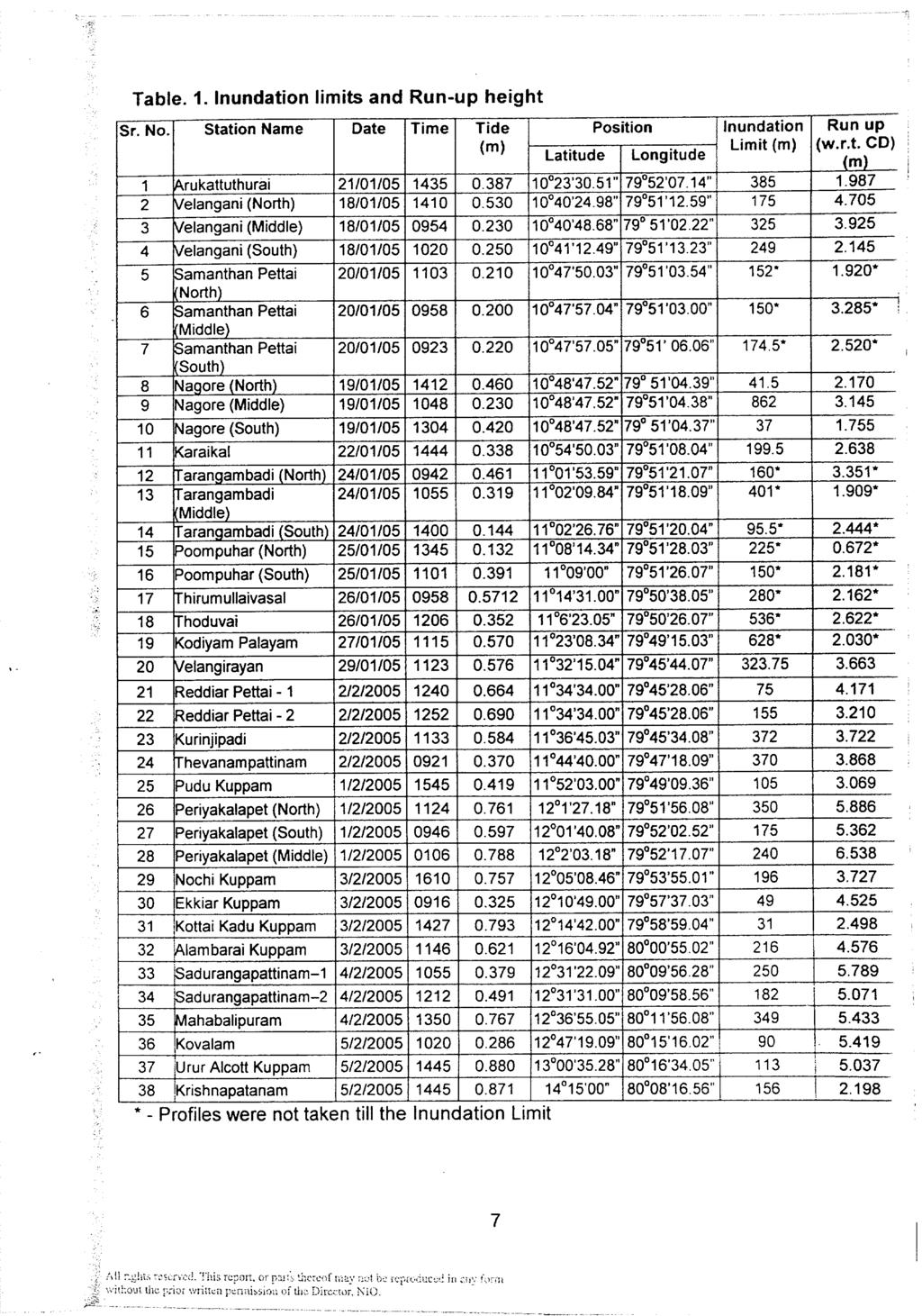
6 period. Heights of 10 consecutive breaking waves (breakers) were visually observed and the average of those heights was noted as the corresponding breaking wave height. Simultaneously, the total time elapsed beginning with the first breaker till the eleventh was averaged and recorded as the corresponding breaker period. The wave direction was visually observed and the approximate values are recorded. Longshore current velocity, surf zone width, wind speed and direction are the parameters observed in this study. Neutrally buoyant floats were released in the surf zone and the distance traveled by them in 2 minutes and the direction of travel was noted. The speed and direction of these floats were noted as the longshore current speed and direction. Surf zone width was visually estimated. Wind speed was observed based on the intensity and noted as calm, mild, moderate, medium, strong or very strong which are assumed as 0, 5, 10, 20, 40, or 60 km/h respectively and the direction was observed with the help of a magnetic compass. 4.4 Beach sediments: Beach surface sediment samples from the inter-tidal region, close to the water line, at each station were collected during the study period and sieve analysis was carried out to study the grain size distribution. 5 BASIC DATA & PRELIMINARY RESULTS 5.1 Cross sectional profiles: The cross sectional profiles at each of the station are presented in the form of graphs and digital data in Appendix - 1. The profiles were terminated at the landward end of the inundation limit. At each of the station, wherever possible more than one profile has been measured one on the north and the other on the south of the entrance to the station. 5.2 Inundation Limit & Run-up height. The inundation limits with respect to local time and the run-up height corresponding to the Chart Datum are presented in Table 1. More than 25 locations were surveyed to assess the inundation limits as well as run-up heights. At most of the locations more than one cross section profile was considered to ascertain the inundation and run-up height values. The inundation limit (for the profiles considered till inundation limit) varied between 31 m and 862 m whereas the run-up height varied between m and m. The minimum inundation limit is observed at Kottaikadu 3 All rights reserved. This report, or parts thereof may not be reproduced in any form without the prior written permission of the Director, NIO.
7 Kuppam and the maximum at Nagore (along mid-profiles). The maximum runup height is observed at Periyakalapet (North) and the minimum run-up height is observed at Arkattuthurai. 5.3 Littoral environmental observations: Breaking wave parameters and the littoral environmental observations at each of the station are presented in Table. 2. It is observed that the breaking wave heights were seen higher in northern region compared to the southern region and so were the wave periods. The Longshore current was predominantly southerly over the region except at some locations where it was northerly. The southerly longshore currents were seen to be grater in magnitude compared to the northerly currents. 5.4 Beach sediments: The inter-tidal beach sediments collected at each of the station were analysed for the grain-size distribution and the data and graphs are presented in Appendix - 2. The median grain-size (D50) values at each of the station are presented in Table. 3. the D50 of the sediments north of Poompuhar were observed to be higher compared to the sediments south of Poompuhar. This could be due to the wave climate, which is higher on the north compared to the south. 6 CONCLUSIONS o The inundation limits estimated from the survey data, where the profiles were taken till inundation limits, showed that the maximum inundation was observed at Nagore (862 m) followed by Arkattuthurai (385 m). The average inundation distance considering the surveyed locations where the profiles were taken till inundation limits was about 237 m. o The run-up heights reduced to Chart Datum showed that the run-up height is higher in the northern region along the Chennai-Pondicherry coast compared to the south along the Poompuhar coast. The maximum run-up height was estimated at Periyakalapet-north (6.53 m) and the minimum at Nagore-north (0.67 m). The average run-up height considering the surveyed locations where the profiles were taken till inundation limits was about 4.0 m. 4
8 o Breaking wave parameters showed that the wave heights as well as wave period were higher in the northern region compared to the southern region. o The littoral environmental observations showed that the longshore currents were predominantly in the southward direction with northerly currents are at few locations. The southward longshore currents were much stronger compared to the northward longshore currents. o The grain size distribution of the inter-tidal sediments showed that the median size varied between mm and mm with an average size of about 0.3 mm. ACKNOWLEDGEMENTS Dr. Satish R Shetye, Director, NIO, Goa has been instrumental in initiating the Post-Tsunami survey. The authors duly acknowledge the support and encouragement provided by the Director, NIO. The local officials at each of the stations and the helpful villagers who had provided the much needed information and co-operation during the survey are greatly acknowledged REFERENCES 1. IOC Manuals and guides No Post Tsunami survey guidelines, Intergovernmental Oceanographic Commission, UNESCO, Field guide for measuring Tsunami run-ups and inundations, State of Hawaii, Dept. of Defense, Civil Defense Division, Tsunami Technical Review Committee, Hawaii, 38P, October 2002.
9
10
11
12
13
14
15
16
17
18
19
20
21
22
23
24
25
26
27
28
29
30
31
32
33
34
35
36
37
38
39
40
41
42
43
44
45
46
47
48
49
50
51
52
53
54
55
56
57
58
59
60
61
62
63
64
65
66
67
68
69
70
71
72
73
74
75
76
77
78
79
80
81
82
83
84
85
86
87
April 7, Prepared for: The Caribbean Disaster Emergency Response Agency Prepared by: CEAC Solutions Co. Ltd.
 April 7, 2006 Prepared for: The Caribbean Disaster Emergency Response Agency Prepared by: Introduction CEAC Solutions Co. Ltd was commissioned in May 2005 to prepare coastal beach erosion hazard maps for
of monsoon waves off U ran, west coast of India
 Indian Journal of Marine Sciences Vol. 18, June 1989,pp.1I3-1I7 Characteristics of monsoon waves off U ran, west coast of India B U Nayak, P Chandramohan & S Mandai National Institute of Oceanography,
Chapter 15 SEASONAL CHANGES IN BEACHES OP THE NORTH ATLANTIC COAST OF THE UNITED STATES
 Chapter 15 SEASONAL CHANGES IN BEACHES OP THE NORTH ATLANTIC COAST OF THE UNITED STATES By John M. Darling Hydraulic Engineer, Research Division U. S. Army Coastal Engineering Research Center Corps of
Available online at ScienceDirect. Procedia Engineering 116 (2015 )
") Available online at www.sciencedirect.com ScienceDirect Procedia Engineering 116 (2015 ) 320 325 8th International Conference on Asian and Pacific Coasts (APAC 2015) Department of Ocean Engineering, IIT
Available online at www.sciencedirect.com ScienceDirect Procedia Engineering 116 (2015 ) 320 325 8th International Conference on Asian and Pacific Coasts (APAC 2015) Department of Ocean Engineering, IIT
Coastal Hazards Study
 Coastal Hazards Study 2212 Beach Boulevard, Pacifica Prepared for: EXECUTIVE SUMMARY City of Pacifica 170 Santa Maria Ave Pacifica, CA 94044 Prepared by: moffatt & nichol 2185 N. California Blvd. Walnut
Shoreline changes and reef strengthening at Kavaratti island in Lakshadweep Archipelago - A case study
 Indian Journal of Geo-Marine Sciences Vol. 43(7), July 2014, pp. 1140-1144 Shoreline changes and reef strengthening at Kavaratti island in Lakshadweep Archipelago - A case study T.N.Prakash*, L.Sheela
COASTAL EROSION: INVESTIGATIONS IN THE SOUTHWEST COAST OF SRI LANKA
 COASTAL EROSION: INVESTIGATIONS IN THE SOUTHWEST COAST OF SRI LANKA Wijayawardane I.S.K. 1, Ansaf K.M.M. 2, Ratnasooriya A.H.R. 3, Samarawickrama S.P. 4 1,2 Postgraduate Student, Department of Civil Engineering,
HURRICANE SANDY LIMITED REEVALUATION REPORT UNION BEACH, NEW JERSEY DRAFT ENGINEERING APPENDIX SUB APPENDIX D SBEACH MODELING
 HURRICANE SANDY LIMITED REEVALUATION REPORT UNION BEACH, NEW JERSEY DRAFT ENGINEERING APPENDIX SUB APPENDIX D SBEACH MODELING Rev. 18 Feb 2015 1 SBEACH Modeling 1.0 Introduction Following the methodology
MODELING OF CLIMATE CHANGE IMPACTS ON COASTAL STRUCTURES - CONTRIBUTION TO THEIR RE-DESIGN
 Proceedings of the 14 th International Conference on Environmental Science and Technology Rhodes, Greece, 3-5 September 2015 MODELING OF CLIMATE CHANGE IMPACTS ON COASTAL STRUCTURES - CONTRIBUTION TO THEIR
UPPER BEACH REPLENISHMENT PROJECT RELATED
 ASSESSMENT OF SAND VOLUME LOSS at the TOWNSHIP of UPPER BEACH REPLENISHMENT PROJECT RELATED to the LANDFALL OF HURRICANE SANDY - PURSUANT TO NJ-DR 4086 This assessment is in response to Hurricane Sandy
Wave Energy & Littoral Drift Off Krishnapatnam
 Indian Journal of Marine Sciences Vol. 11, March 1982, pp. 2631 Wave Energy & Littoral Drift Off Krishnapatnam B S R REDDY, G VEKATA REDDY' & K HEMATHA KUMAR Department of Meteorology & Oceanography, Andhra
Appendix M: Durras Lake Tailwater Conditions
 Appendix M: Durras Lake Tailwater Conditions M.1 Preamble WRL has completed a tailwater condition assessment for the entrance to Durras Lake, to be used as an ocean boundary condition for a future flood
Natural Bridges Field Trip Activity
 Natural Bridges Field Trip Activity This is due in class on MONDAY- March 1 - not in sections! Name TA: NOTE ON THE GRADING OF THIS ASSIGNMENT: Many of the questions below (especially in the tidepool part)
Long Beach Island Holgate Spit Little Egg Inlet Historical Evolution Introduction Longshore Transport Map, Survey and Photo Historic Sequence
 Appendix B Long Beach Island Holgate Spit Little Egg Inlet Historical Evolution Introduction The undeveloped southern end of Long Beach Island (LBI) is referred to as the Holgate spit as it adjoins the
Artificial headlands for coastal restoration
 Artificial headlands for coastal restoration J. S. Mani Professor, Department of Ocean Engineering, Indian Institute of Technology Madras, Chennai 636, India Abstract Construction of a satellite harbour
Beach Profiles. Topics. Module 9b Beach Profiles and Crossshore Sediment Transport 3/23/2016. CE A676 Coastal Engineering
 Beach Profiles AND CROSS-SHORE TRANSPORT Orson P. Smith, PE, Ph.D., Professor Emeritus Topics Features of beach and nearshore profiles Equilibrium profiles Cross-shore transport References Text (Sorensen)
SPECIAL SPRING 2018 STORM REPORT ON THE CONDITION OF THE MUNICIPAL BEACHES FOR THE BOROUGH OF STONE HARBOR, CAPE MAY COUNTY, NEW JERSEY
 SPECIAL SPRING 2018 STORM REPORT ON THE CONDITION OF THE MUNICIPAL BEACHES FOR THE BOROUGH OF STONE HARBOR, CAPE MAY COUNTY, NEW JERSEY Aerial photograph taken April 21, 2018 showing the view up the beach
The events associated with the Great Tsunami of 26 December 2004 Sea Level Variation and Impact on Coastal Region of India
 The events associated with the Great Tsunami of 26 December 2004 Sea Level Variation and Impact on Coastal Region of India Satish R. Shetye National Institute of Oceanography, Goa Tsunamis are shallow-water
Beach Nourishment Impact on Beach Safety and Surfing in the North Reach of Brevard County, Florida
 Beach Nourishment Impact on Beach Safety and Surfing in the North Reach of Brevard County, Florida Prepared by John Hearin, Ph.D. Coastal Engineering Vice Chairman Cocoa Beach Chapter Port Canaveral Patrick
Inspection of Clarence City Beaches following Winter 2011 Storm Events
 18 July 2011 WRL Ref: WRL10086TDS L20110718 Messrs P Watson & I Preece Clarence City Council PO Box 96 Rosny Park TAS 7018 By email: pwatson@ccc.tas.gov.au ipreece@ccc.tas.gov.au Dear Phil/Ian, Inspection
Photo by: Darryl Hatheway, 2011
 Photo by: Darryl Hatheway, 2011 September 11, 2015 Presentation Discussion Examine PFD V-Zone Mapping in Wave Runup Dominated West Coast Application of PFD V-Zone Mapping Criteria in Pacific G&S PFD V-Zone
Concepts & Phenomena
 Concepts & Phenomena in coastal and port sedimentation R. Kamalian Ports and Maritime Organization of Iran and PIANC-Iran 7 9 December 2015 What is the problem? Many harbours have sedimentation problems
Public Works Department Tamil Nadu.
 IIT Madras RISK ASSESSMENT AND DISASTER MANAGEMENT PLAN FOR NORTH CHENNAI, TAMIL NADU. Report Submitted to Public Works Department Tamil Nadu. By, Prof. V. Sundar Prof. S.A. Sannasiraj Chennai 600 036,
HARBOUR SEDIMENTATION - COMPARISON WITH MODEL
 HARBOUR SEDIMENTATION - COMPARISON WITH MODEL ABSTRACT A mobile-bed model study of Pointe Sapin Harbour, in the Gulf of St. Lawrence, resulted in construction of a detached breakwater and sand trap to
Sussex County, DE Preliminary Study Overview
 Sussex County, DE Preliminary Study Overview Coastal study scope: 102 miles of entire County shoreline Revised 102 panels for coastal study Riverine study scope: 14 streams, 67.1 miles, within the Nanticoke
CHAPTER 8 ASSESSMENT OF COASTAL VULNERABILITY INDEX
 124 CHAPTER 8 ASSESSMENT OF COASTAL VULNERABILITY INDEX 8.1 INTRODUCTION In order to assess the vulnerability of the shoreline considered under this study against the changing environmental conditions,
PROPAGATION OF LONG-PERIOD WAVES INTO AN ESTUARY THROUGH A NARROW INLET
 PROPAGATION OF LONG-PERIOD WAVES INTO AN ESTUARY THROUGH A NARROW INLET Takumi Okabe, Shin-ichi Aoki and Shigeru Kato Department of Civil Engineering Toyohashi University of Technology Toyohashi, Aichi,
To: William Woods, Jenni Austin Job No: CentrePort Harbour Deepening Project - Comments on community queries
 Memo To: William Woods, Jenni Austin From: Richard Reinen-Hamill Date: Subject: cc: 1 Purpose This memo sets out our response to issues raised at and after Seatoun community consultation sessions held
COASTAL ENVIRONMENTS. 454 lecture 12
 COASTAL ENVIRONMENTS Repeated movement of sediment & water constructs a beach profile reflecting the balance between average daily or seasonal wave forces and resistance of landmass to wave action Coasts
Open Pacific Coast Study. California Coastal Analysis and Mapping Project
 Open Pacific Coast Study California Coastal Analysis and Mapping Project September 2012 California Open Coast Counties California Coastal Analysis and Mapping Project This publication is an initiative
LOCALLY CONCENTRATED SEVERE BEACH EROSION ON SEISHO COAST CAUSED BY TYPHOON T0709
 F-4 Fourth International Conference on Scour and Erosion 2008 LOCALLY CONCENTRATED SEVERE BEACH EROSION ON SEISHO COAST CAUSED BY TYPHOON T0709 Yoshimitsu TAJIMA 1 and Shinji SATO 2 1 Member of JSCE, Associate
ENSO and monsoon induced sea level changes and their impacts along the Indian coastline
 Indian Journal of Marine Sciences Vol. 35(2), June 2006, pp. 87-92 ENSO and monsoon induced sea level changes and their impacts along the Indian coastline O.P.Singh* Monsoon Activity Centre, India Meteorological
0460 GEOGRAPHY. 0460/41 Paper 4 (Alternative to Coursework), maximum raw mark 60
, maximum raw mark 60") CAMBRIDGE INTERNATIONAL EXAMINATIONS Cambridge International General Certificate of Secondary Education MARK SCHEME for the May/June 2015 series 0460 GEOGRAPHY 0460/41 Paper 4 (Alternative to Coursework),
CAMBRIDGE INTERNATIONAL EXAMINATIONS Cambridge International General Certificate of Secondary Education MARK SCHEME for the May/June 2015 series 0460 GEOGRAPHY 0460/41 Paper 4 (Alternative to Coursework),
Our Council s Own: Oceanography Cadette/Senior/Ambassador Badge
 Our Council s Own: Oceanography Cadette/Senior/Ambassador Badge Oceanography: The science that deals with oceans, the delimitation of their extent and depth, the physics and chemistry of their water, marine
2016 NC Coastal Local Governments Annual Meeting
 2016 NC Coastal Local Governments Annual Meeting Coastal Flood Study Modeling and Mapping 101 April 21, 2016 Tom Langan, PE, CFM Engineering Supervisor NCEM Floodplain Mapping Program FEMA Coastal Flood
Volume and Shoreline Changes along Pinellas County Beaches during Tropical Storm Debby
 Volume and Shoreline Changes along Pinellas County Beaches during Tropical Storm Debby Ping Wang and Tiffany M. Roberts Coastal Research Laboratory University of South Florida July 24, 2012 Introduction
Shoreline Response to an Offshore Wave Screen, Blairgowrie Safe Boat Harbour, Victoria, Australia
 Shoreline Response to an Offshore Wave Screen, Blairgowrie Safe Boat Harbour, Victoria, Australia T.R. Atkins and R. Mocke Maritime Group, Sinclair Knight Merz, P.O. Box H615, Perth 6001, Australia ABSTRACT
Environmental Protection on the Gold Coast of Queensland, Australia. 1. What is the appeal of the Gold Coast to tourists?
 Environmental Protection on the Gold Coast of Queensland, Australia Sections 1. What is the appeal of the Gold Coast to tourists? 2. How are Gold Coast visitor trends changing? 3. How can the impacts of
Reading Material. Inshore oceanography, Anikouchine and Sternberg The World Ocean, Prentice-Hall
 Reading Material Inshore oceanography, Anikouchine and Sternberg The World Ocean, Prentice-Hall BEACH PROCESSES AND COASTAL ENVIRONMENTS COASTAL FEATURES Cross section Map view Terminology for Coastal
4/20/17. #30 - Coastlines - General Principles Coastlines - Overview
 Writing Assignment Due one week from today by 11:59 pm See main class web pages for detailed instructions Essays will be submitted in Illinois Compass (instructions later) Pick one: Earthquakes, tsunamis,
WIND SPEED LENGTH OF TIME WIND BLOWS (Duration) DISTANCE OVER WHICH IT BLOWS (Fetch)
 DISTANCE OVER WHICH IT BLOWS (Fetch)") WAVES Up and down movement of ocean surface Transportation of energy across the water over vast distances If not stopped by anything, waves can travel entire oceans Size and speed depend upon: WIND SPEED
WAVES Up and down movement of ocean surface Transportation of energy across the water over vast distances If not stopped by anything, waves can travel entire oceans Size and speed depend upon: WIND SPEED
City of Del Mar Local Coastal Plan (LCP) Amendment for Sea Level Rise and Coastal Flooding
 Amendment for Sea Level Rise and Coastal Flooding") City of Del Mar Local Coastal Plan (LCP) Amendment for Sea Level Rise and Coastal Flooding 6/22/17 Presentation to Sea Level Rise Stakeholder- Technical Advisory Committee (STAC) Nick Garrity, P.E. Lindsey
City of Del Mar Local Coastal Plan (LCP) Amendment for Sea Level Rise and Coastal Flooding 6/22/17 Presentation to Sea Level Rise Stakeholder- Technical Advisory Committee (STAC) Nick Garrity, P.E. Lindsey
consulting engineers and scientists
 consulting engineers and scientists Coastal Processes Presented by: January 9, 2015 Varoujan Hagopian, P.E. F.ASCE Senior Consultant, Waterfront Engineer Living Shoreline Workshop Lets Remember Why We
Puducherry Port Disaster. A Man-Made Made Tsunami. Coastal Erosion at Puducherry. & neighboring beaches of Tamil Nadu
 Puducherry Port Disaster A Man-Made Made Tsunami Coastal Erosion at Puducherry & neighboring beaches of Tamil Nadu Pondicherry Citizens Action Network February 2007 Once upon a time Pondicherry had a beautiful
Technical Brief - Wave Uprush Analysis Island Harbour Club, Gananoque, Ontario
 Technical Brief - Wave Uprush Analysis RIGGS ENGINEERING LTD. 1240 Commissioners Road West Suite 205 London, Ontario N6K 1C7 October 31, 2014 Table of Contents Section Page Table of Contents... i List
Appendix E Cat Island Borrow Area Analysis
 Appendix E Cat Island Borrow Area Analysis ERDC/CHL Letter Report 1 Cat Island Borrow Area Analysis Multiple borrow area configurations were considered for Cat Island restoration. Borrow area CI1 is located
K. Ayyappan Research Scholar, Department of Harbor and Ocean Engineering. K. Thiruvenkatasamy Professor, Department of Harbor and Ocean Engineering
 International Journal of Civil Engineering and Technology (IJCIET) Volume 9, Issue 6, June 218, pp. 912 922, Article ID: IJCIET_9_6_14 Available online at http://www.iaeme.com/ijciet/issues.asp?jtype=ijciet&vtype=9&itype=6
Activity #1: The Dynamic Beach
 Activity #1: The Dynamic Beach Beach Profiling By Betsy Sheffield, COASTeam Program, College of Charleston, Charleston, SC Subjects: Science, Math Skills: Analysis, description, listing, research, small
METHODS OF DATA COLLECTION AND ANALYSIS
 CHAPTER 3 METHODS OF DATA COLLECTION AND ANALYSIS Field observations are carried out using the facilities available in the coastal laboratory of the Centre for Earth Science Studies at Valiathura. Nearshore
Coastal management has lagged behind the growth in population leading to problems with pollution
 Fifty percent of the population of the industrialized world lives within 100 km of a coast. Coastal management has lagged behind the growth in population leading to problems with pollution and natural
COFFS HARBOUR SEDIMENT MODELLING AND INVESTIGATION
 COFFS HARBOUR SEDIMENT MODELLING AND INVESTIGATION Luke McAvoy Undergraduate Engineer (Civil) Griffith School of Engineering, Griffith University, Gold Coast, Australia Daniel Rodger Senior Engineer Water
CROSS-SHORE SEDIMENT PROCESSES
 The University of the West Indies Organization of American States PROFESSIONAL DEVELOPMENT PROGRAMME: COASTAL INFRASTRUCTURE DESIGN, CONSTRUCTION AND MAINTENANCE A COURSE IN COASTAL DEFENSE SYSTEMS I CHAPTER
An evaluation of XBT depth equations for the Indian Ocean
 Deep-Sea Research I 45 (1998) 819 827 Instruments and methods An evaluation of XBT depth equations for the Indian Ocean Pankajakshan Thadathil*, Aravind K. Ghosh, P.M. Muraleedharan National Institute
Directed Reading. Section: Ocean Currents. a(n). FACTORS THAT AFFECT SURFACE CURRENTS
. FACTORS THAT AFFECT SURFACE CURRENTS") Skills Worksheet Directed Reading Section: Ocean Currents 1. A horizontal movement of water in a well-defined pattern is called a(n). 2. What are two ways that oceanographers identify ocean currents? 3.
Skills Worksheet Directed Reading Section: Ocean Currents 1. A horizontal movement of water in a well-defined pattern is called a(n). 2. What are two ways that oceanographers identify ocean currents? 3.
Name Class Date. Use the terms from the following list to complete the sentences below. Each term may be used only once. Some terms may not be used.
 Assessment Chapter Test B The Movement of Ocean Water USING KEY TERMS Use the terms from the following list to complete the sentences below. Each term may be used only once. Some terms may not be used.
LAB: WHERE S THE BEACH
 Name: LAB: WHERE S THE BEACH Introduction When you build a sandcastle on the beach, you don't expect it to last forever. You spread out your towel to sunbathe, but you know you can't stay in the same spot
Currents measurements in the coast of Montevideo, Uruguay
 Currents measurements in the coast of Montevideo, Uruguay M. Fossati, D. Bellón, E. Lorenzo & I. Piedra-Cueva Fluid Mechanics and Environmental Engineering Institute (IMFIA), School of Engineering, Research
Northwest Hydraulic Consultants (NHC) is pleased to submit this assessment of the wave climate at Lazo Road, Comox.
 is pleased to submit this assessment of the wave climate at Lazo Road, Comox.") 405 495 Dunsmuir Street Nanaimo, B.C. V9R 6B9 250.754.6425 www.nhcweb.com NHC Ref. No. 03000276 21 November 2014 Wedler Engineering LLP #211-2459 Cousins Avenue Courtenay, BC V9N 3N6 Attention: Andrew
405 495 Dunsmuir Street Nanaimo, B.C. V9R 6B9 250.754.6425 www.nhcweb.com NHC Ref. No. 03000276 21 November 2014 Wedler Engineering LLP #211-2459 Cousins Avenue Courtenay, BC V9N 3N6 Attention: Andrew
Future Condi,ons coastal hazard modeling and mapping
 Future Condi,ons coastal hazard modeling and mapping Presented by Bob Ba:alio, PE Environmental Science Associates, Inc. (ESA) On behalf of the physical processes team (USGS, TerraCosta- Scripps, ESA)
Compiled by Uwe Dornbusch. Edited by Cherith Moses
 REPORT ON WAVE AND TIDE MEASUREMENTS Compiled by Uwe Dornbusch. Edited by Cherith Moses 1 Aims...1 2 Summary...1 3 Introduction...1 4 Site selection...1 5 Wave recorder settings...2 6 Results...2 6.1 Water
IMPACTS OF COASTAL PROTECTION STRATEGIES ON THE COASTS OF CRETE: NUMERICAL EXPERIMENTS
 IMPACTS OF COASTAL PROTECTION STRATEGIES ON THE COASTS OF CRETE: NUMERICAL EXPERIMENTS Tsanis, I.K., Saied, U.M., Valavanis V. Department of Environmental Engineering, Technical University of Crete, Chania,
Request Number IR1-12: Flow Passage. Information Request
 Request Number IR1-12: Flow Passage Information Request Provide additional information about the 100 metre flow passage channel scenario between the Westshore Terminals and the proposed Project terminal
A REVIEW OF THE CONDITION OF THE MUNICIPAL BEACHES AS A RESULT OF HURRICANE SANDY IN THE BOROUGH OF STONE HARBOR, CAPE MAY COUNTY, NEW JERSEY
 A REVIEW OF THE CONDITION OF THE MUNICIPAL BEACHES AS A RESULT OF HURRICANE SANDY IN THE BOROUGH OF STONE HARBOR, CAPE MAY COUNTY, NEW JERSEY View along the dune scarp from 103 rd Street on October 31,
Town of Duck, North Carolina
 Tracking No. 00.00.2010 Erosion Mitigation And Shoreline Management Feasibility Study Town of Duck, North Carolina Coastal Planning & Engineering of North Carolina August 15, 2012 Tom Jarrett Robert Neal
CHAPTER 179. Performance of a Submerged Breakwater for Shore Protection
 CHAPTER 179 Abstract Performance of a Submerged Breakwater for Shore Protection Albert E. Browder',A. Member, ASCE; Robert G. Dean 2, Member, ASCE; and Renjie Chen 3 A summary is presented of the results
Chapter 22, Section 1 - Ocean Currents. Section Objectives
 Chapter 22, Section 1 - Ocean Currents Section Objectives Intro Surface Currents Factors Affecting Ocean Currents Global Wind Belts (you should draw and label a diagram of the global wind belts) The Coriolis
The ocean water is dynamic. Its physical
 CHAPTER MOVEMENTS OF OCEAN WATER The ocean water is dynamic. Its physical characteristics like temperature, salinity, density and the external forces like of the sun, moon and the winds influence the movement
THE :1;TUDY OF :HZ- SEA S -: 4 -.,1E D Ti=k COLLCTEZ FROM OF BENGAL DURI:1'
 THE :1;TUDY OF :HZ- SEA S -: 4 -.,1E D Ti=k COLLCTEZ FROM OF BENGAL DURI:1'71 1964-65 R. RAJENDRAN AND R. L. ROY CHOUDHURY Central institute of Fisheries Technology, Cochin-5 The wave data collected on
Wind Blow-out Hollow Generated in Fukiage Dune Field, Kagoshima Prefecture, Japan
 R. Nishi Wind Blow-out Hollow Generated in Fukiage Dune Field, Kagoshima Prefecture, Japan Ryuichiro Nishi, Li Elikson and Myokhin PREFACE A sand dune is vulnerable to severe waves and wind. Therefore,
CHAPTER 134 INTRODUCTION
 CHAPTER 134 NEW JETTIES FOR TUNG-KANG FISHING HARBOR, TAIWAN Chi-Fu Su Manager Engineering Department Taiwan Fisheries Consultants, Inc. Taipei, Taiwan INTRODUCTION Tung-Kang Fishing Harbor, which is about
NTHMP - Mapping & Modeling Benchmarking Workshop: Tsunami Currents
 NTHMP - Mapping & Modeling Benchmarking Workshop: Tsunami Currents Ahmet Cevdet Yalçıner, Andrey Zaytsev, Utku Kanoğlu Deniz Velioglu, Gozde Guney Dogan, Rozita Kian, Naeimeh Shaghrivand, Betul Aytore
New Jersey Beach Profile Network Atlantic County Profile Site Locations
 215 RICHARD STOCKTON COLLEGE OF NEW JERSEY New Jersey Beach Profile Network Atlantic County Profile Site Locations COASTAL RESEARCH CENTER Figure 128 There are nine NJBPN survey sites on the Atlantic County
SOME WATER CHARACTERISTICS OF ESTUARIES IN INDONESIA
 SOME WATER CHARACTERISTICS OF ESTUARIES IN INDONESIA by HENK L. UKTOLSEYA 1 ABSTRACT This paper describes the results obtained during several hydro-oceanographical observations of some estuaries in Indonesia
Essentials of Oceanography Eleventh Edition
 Chapter Chapter 1 10 Clickers Lecture Essentials of Oceanography Eleventh Edition The Coast: Beaches and Shoreline Processes Alan P. Trujillo Harold V. Thurman Chapter Overview Coastal regions have distinct
Feasibility Study for Restoration of Titlow Lagoon Fish Passage. South Puget Sound Salmon Enhancement Group
 Feasibility Study for Restoration of Titlow Lagoon Fish Passage South Puget Sound Salmon Enhancement Group January 2010 Feasibility Study for Restoration of Titlow Lagoon Fish Passage Prepared for South
SORTING AND SELECTIVE MOVEMENT OF SEDIMENT ON COAST WITH STEEP SLOPE- MASUREMENTS AND PREDICTION
 SORTING AND SELECTIVE MOVEMENT OF SEDIMENT ON COAST WITH STEEP SLOPE- MASUREMENTS AND PREDICTION Toshiro San-nami 1, Takaaki Uda 2, Masumi Serizawa 1 and Toshinori Ishikawa 2 Conveyer belts carrying gravel
Coastal erosion triggered by a shipwreck along the coast of Goa, India
 Coastal erosion triggered by a shipwreck along the coast of Goa, India R. Mani Murali*, M. T. Babu, Antonio Mascarenhas, Richa Choudhary, K. Sudheesh and P. Vethamony CSIR National Institute of Oceanography,
SELECTION OF THE PREFERRED MANAGEMENT OPTION FOR STOCKTON BEACH APPLICATION OF 2D COASTAL PROCESSES MODELLING
 SELECTION OF THE PREFERRED MANAGEMENT OPTION FOR STOCKTON BEACH APPLICATION OF 2D COASTAL PROCESSES MODELLING C Allery 1 1 DHI Water and Environment, Sydney, NSW Abstract This paper presents an approach
SHOREHAM BEACH LOCAL NATURE RESERVE
 SHOREHAM BEACH LOCAL NATURE RESERVE Coastal Geography Education Programme 2014-15 S. Savage 2014 COASTAL GEOGRAPHY OPPORTUNITIES Shoreham Beach Shoreham Beach is a shingle spit formed over many centuries
Bob Battalio, PE Chief Engineer, ESA September 8, 2016
 RELATING FUTURE COASTAL CONDITIONS TO EXISTING FEMA FLOOD HAZARD MAPS Technical Methods Manual Bob Battalio, PE Chief Engineer, ESA September 8, 2016 FMA 2016 Sacramento, California DWR-OST-SIO PILOTING
Geology 15 Activity 5 A Tsunami
 Materials: Marigram recorded in San Diego, May 23, 1960. Travel Time Graph To San Diego. Answer sheet Source of information: Lander, James F., Patricia A. Lockridge and Michael J. Kozuch, s Affecting the
Cambridge International Examinations Cambridge International General Certificate of Secondary Education
 Cambridge International Examinations Cambridge International General Certificate of Secondary Education *4574868004* GEOGRAPHY 0460/43 Paper 4 Alternative to Coursework October/November 2017 Candidates
The frequently asked questions are grouped under headings to make it easier to find information -
 Tsunami Inundation Mapping for Hawke s Bay Frequently Asked Questions The frequently asked questions are grouped under headings to make it easier to find information - General tsunami information Tsunami
WATERWAYS AND HARBORS DIVISION Proceedings of the American Society of Civil Engineers. EQUILIBRIUM FLOW AREAS OF INLETS ON SANDY COASTS a
 6405 February, 1969 WWl J oumal of the WATERWAYS AND HARBORS DIVISION Proceedings of the American Society of Civil Engineers EQUILIBRIUM FLOW AREAS OF INLETS ON SANDY COASTS a By Morrough P. O'Brien,!
Habitat Fact Sheets. Rocky habitats are dominated by seaweeds and often mussels, which rely on the rocks for attachment.
 Habitat Fact Sheets Habitats in the Gulf of Maine serve many important roles for the environment and for humans as well. These include: cycling nutrients, filtering pollution, trapping sediments, storing
G. Meadows, H. Purcell and L. Meadows University of Michigan
 www.coj.net/departments/fire+and+rescue/emergency+preparedness/rip+current.htm G. Meadows, H. Purcell and L. Meadows Over 80% of all surf related rescues are attributable to Rip Currents According to the
CHAPTER 6 DISCUSSION ON WAVE PREDICTION METHODS
 CHAPTER 6 DISCUSSION ON WAVE PREDICTION METHODS A critical evaluation of the three wave prediction methods examined in this thesis is presented in this Chapter. The significant wave parameters, Hand T,
A study of the monsoonal beach processes around Alleppey, Kerala
 Proc. Indian Acad. Sci. (Earth Planet. Sci.), Vol. 94, No. 3, November 1985, pp. 323-332. 9 Printed in India. A study of the monsoonal beach processes around Alleppey, Kerala N P KURIAN, T S SHAHUL HAMEED
Nearshore Morphodynamics. Bars and Nearshore Bathymetry. Sediment packages parallel to shore, that store beach sediment
 Nearshore Morphodynamics http://coastal.er.usgs.gov/bier/images/chandeleur-xbeach-lg.jpg Bars and Nearshore Bathymetry Sediment packages parallel to shore, that store beach sediment Can be up to 50 km
SEASONDE DETECTION OF TSUNAMI WAVES
 SEASONDE DETECTION OF TSUNAMI WAVES Belinda Lipa, John Bourg, Jimmy Isaacson, Don Barrick, and Laura Pederson 1 I. INTRODUCTION We here report on preliminary results of a study to assess the capability
Chapter. The Dynamic Ocean
 Chapter The Dynamic Ocean An ocean current is the mass of ocean water that flows from one place to another. 16.1 The Composition of Seawater Surface Circulation Surface Currents Surface currents are movements
Site The fieldwork should be completed at a localised site on the Victorian coast (or elsewhere).
.") Coastal fieldwork Studying the coast provides the opportunity to conduct fieldwork in coastal regions. This fieldwork could investigate the geographic characteristics of the coast and how they change over
Coastal fieldwork Studying the coast provides the opportunity to conduct fieldwork in coastal regions. This fieldwork could investigate the geographic characteristics of the coast and how they change over
/50. Physical Geology Shorelines
 Physical Geology Shorelines Multiple Guess: (You know the drill 2 points each) 1. The path of movement of a water particle in a wave at sea is 1. circular 2. horizontal 3. vertical 4. elliptical 5. none
Influence of oceanographic processes on coastal erosion, morphology and inundation
 FACULTY OF ENGINEERING, COMPUTING AND MATHEMATICS Influence of oceanographic processes on coastal erosion, morphology and inundation Charitha Pattiaratchi School of Civil, Environmental and Mining Engineering
Figure 4, Photo mosaic taken on February 14 about an hour before sunset near low tide.
 The Impact on Great South Bay of the Breach at Old Inlet Charles N. Flagg and Roger Flood School of Marine and Atmospheric Sciences, Stony Brook University Since the last report was issued on January 31
EROSION MECHANICS OF A CARBONATE- TOMBOLO BEACH IN MIYAKOJIMA ISLAND, OKINAWA PREFECTURE, JAPAN.
 EROSION MECHANICS OF A CARBONATE- TOMBOLO BEACH IN MIYAKOJIMA ISLAND, OKINAWA PREFECTURE, JAPAN. Ryuichiro NISHI 1, Takaaki UDA 2, Akio KIKUCHI 3 and Kou FURUIKE 4 1) Associate Prof. Dept. of Ocean Civil
Beach Profiles: Monitoring Sea Level Rise. Student Activity Sheet. Name Date Class
 Beach Profiles: Monitoring Sea Level Rise Student Activity Sheet Name Date Class A shoreline is the area where the water and land meet. This is where we find beach: areas where sediments (sand or other
Chapter 10 Lecture Outline. The Restless Oceans
 Chapter 10 Lecture Outline The Restless Oceans Focus Question 10.1 How does the Coriolis effect influence ocean currents? The Ocean s Surface Circulation Ocean currents Masses of water that flow from one
g) Use the map compass to provide the general locality of the knoll on the chart.
 Use the map compass to provide the general locality of the knoll on the chart.") The horizontal scale (x axis) of your cross-section/profile is the linear map distance between point A and point B on the map (or between X and Y and Z). It conforms to the map scale. In other words, the
The horizontal scale (x axis) of your cross-section/profile is the linear map distance between point A and point B on the map (or between X and Y and Z). It conforms to the map scale. In other words, the
Shorelines Earth - Chapter 20 Stan Hatfield Southwestern Illinois College
 Shorelines Earth - Chapter 20 Stan Hatfield Southwestern Illinois College The Shoreline A Dynamic Interface The shoreline is a dynamic interface (common boundary) among air, land, and the ocean. The shoreline