Guide to travelling to and around Panmure April 2013
|
|
|
- Francine Sherilyn Neal
- 5 years ago
- Views:
Transcription
1 Guide to travelling to and around Panmure April 2013

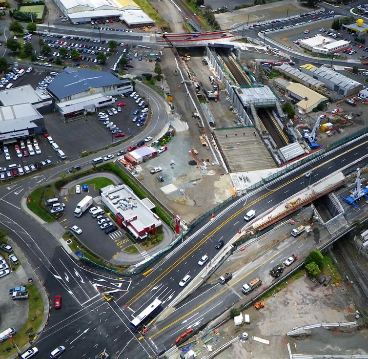
2 AMETI Phase One Construction 2 2
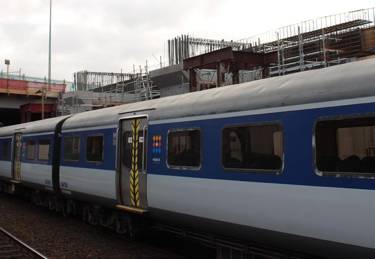
3 This guide provides an overview of travel options to and through the Panmure area as construction proceeds on the AMETI project. Please note that as construction progresses some arrangements will change. Go to for the latest updates. AMETI is a group of transport projects for the eastern suburbs that will give travellers greater choice by improving public transport, walking and cycling facilities and reducing traffic congestion. AMETI will also unlock the economic potential of the area by improving strategic transport links. AMETI Panmure involves a number of major projects, which are mostly underway. These includes: Project Intended work Pedestrian Plaza Now open Mountain Road bridge replacement and realignment of road to Jellicoe/Pleasant View Rd intersection Now open, speed restrictions in place Panmure Station Upgrade Construction of the new station building and other improvements until 2014 Busway bridge completion and Ellerslie Panmure Highway bridge replacement Northbound traffic to Glen Innes diverted via Forgeway from 28 October 2012 to August 2013 Ellerslie-Panmure Highway traffic diverted to busway bridge 25 November 2012 to August 2013 November to Christmas 2012 Ellerslie Panmure Highway bridge demolished New Ellerslie Panmure Highway bridge built from late 2012 to August 2013 Ellerslie Panmure Highway bridge operational about August Busway bridge operational for buses late 2013 AMETI Link Road Construction of new road north - south Tunnel for new road Further details on AMETI and updates on the construction activities around Panmure can be found here. 3

4 Travelling around the area on foot Please be aware there are changes to pedestrian access in the area, particularly around Panmure Station, while construction is underway. This includes the closure of the Ellerslie Panmure Highway footpath on the south side between Panmure Roundabout and Forge Way. Major improvements for pedestrians, including a number of upgrads of new footpaths, are being made as part of the AMETI project. For your safety use footpaths and designated crossings and follow detours where marked. The current pedestrian routes are shown in this map. Carpooling Let s Carpool is the easy way to find a carpool match. Join the rapidly expanding community of members to find carpool partners for your regular commute or a one-off trip. Just register, find a match and share a ride. This is a free, secure service from Auckland Transport that finds carpool matches for you. See the LET S CARPOOL website to find out more or sign up at: Many people recognise the benefits of sharing a ride including taking advantage of transit lanes which give priority to carpoolers at peak times. See the Auckland Transport website for a map of transit lanes across Auckland. 4

5 Pedestrian access to Panmure Station Jellicoe Rd Queens Rd Lagoon Dr Mountain Rd Potaka Ln West Park n Ride East Park n Ride Ireland Rd Platform 2 Papakura/Manukau Platform 1 Britomart Construction area Footpath closed Forge Way Key Road Closed Pedestrian access New bridge Pedestrian crossing Station access Do Not Cross Road Closed Pedestrian crossing Pedestrian crossing 5

6 Travelling by bicycle The AMETI project will see a major improvement for cyclists in the area, with new cycle lanes both on and off road being created. Although there are currently few dedicated cycling facilities in and around Panmure the area has important through routes for both commuting and recreational cyclists. Traffic lanes have been reduced along Ellerslie-Panmure Highway and a diversion put in place for some traffic to allow for construction. While construction is underway in the area, the main recommended routes, shown on the map below, for cyclists are: Use Mountain Road to travel between Ellerslie Panmure Highway and the Panmure Roundabout (follow the detour signs) Use Forge Way and Mountain Road to ride between the Ellerslie Panmure Highway and the Panmure Roundabout. The recently opened new section of Mountain Road, including the new bridge, has a wide road and wide footpaths. An alternative is to dismount and use the footpaths as directed through the construction section. The Central Auckland Cycle Map provides more information about cycling in the Panmure area. These free maps can be viewed on and ordered through the Auckland Transport website Auckland Cycle Maps or picked up from bike shops, libraries and other community venues. 6
7 Cross at the pedestrian crossing Cross at the pedestrian crossing Recommended Cycle Routes Pillkington Rd Dunn Rd Green Rd Jellicoe Rd Pleasant View Rd Dunlop Ln Queens Rd Lagoon Dr Mt Wellington Mt Wellington Domain Panmure Mountain Rd Forge Way Construction area Ireland Rd Ellerslie Panmure Hwy Mt Wellington Hwy Confident rider route Novice/avoid the roundabout New bridge 7
8 Travelling by car Due to construction, speeds are restricted to 30km and lanes reduced from three to two westbound on the section of Ellerslie-Panmure Highway between the roundabout and Mt Wellington Highway. From 28 October 2012 until about August 2013 there are major traffic changes to allow demolition of the Ellerslie-Panmure Highway (EPH) bridge and construction of a new one. This includes a diversion and the Ellerslie-Panmure Highway eastbound lanes between Forge Way and Panmure roundabout reduced from two to one. Heading north to Jellicoe Rd/Glen Innes? Use the left lane and follow the diversion via Forge Way and Mountain Rd bridge Heading east to Panmure town centre or Pakuranga? Traffic will be reduced to one lane approaching Panmure roundabout. Please use the right hand lane on Ellerslie-Panmure Highway and continue to come through the roundabout. Buses and trucks for all destinations should also use the right lane. Traffic heading south or west from Glen Innes/Jellicoe Rd, Panmure, Pakuranga and Howick will continue to come through the roundabout and on Ellerslie-Panmure Highway. Please check signs to ensure you get in the correct lane early and be aware traffic will be much busier at peak times. Consider travelling earlier or later if possible, or using public transport if it works for your journey. From late November 2012 until about August 2013 traffic will use a new Ellerslie-Panmure Highway bridge next to the old one. This map shows the current routes for traffic through Panmure. To help you plan your journey and consider your options, approximate travel times by car to and through Panmure during the am peak are provided below: To Panmure Howick village (via Pakuranga) Botany Town Centre (via Te Irirangi + Ti Rakau + Lagoon Drive) Burswood (via Pakuranga Hwy + Lagoon Drive Pakuranga Shopping Centre 6 5 Otahuhu (via Mt Wellington Hwy) 9 9 Ellerslie (Ellerslie -Panmure Highway) CBD via Glen Innes CBD via Great South Road From Panmure *These am-peak times are approximate and averaged from Auckland Transport data collection during the month of June

9 Traffic routes Pillkington Rd Morrin Rd Dunn Rd Green Rd Jellicoe Rd Pleasant View Rd Dunlop Ln Queens Rd Lagoon Dr Construction area Mt Wellington Mt Wellington Domain Panmure Mountain Rd Forge Way Ireland Rd to Glen Innes Jellicoe Rd Ellerslie Panmure Hwy to Panmure Howick Mt Wellington Hwy to Glen Innes Jellicoe Rd one lane only east New bridge to Panmure Howick Left turn only 9

10 Travelling by public transport Bus and train timetable information is available from the AT Public Transport website it also has a Personal Journey Planner that can help you plan your trip. It also has the most up to date information about any changes that may affect your journey by public transport in Panmure. Train The train service is fully operational and travel times are not affected by construction activities. Other than some weekends and public holidays when trains aren t running for rail electrification work see However the construction work will see changes around the station, passengers should take care on platforms as they will be narrowed in places to allow for construction work. Examples of average train journey times during the morning peak hours are shown below*: Panmure to Britomart Travel time 18 mins Otahuhu 10 mins *These times are taken from the Auckland Transport Train Timetable The frequency of Britomart services varies during the day with an increased number of trains running between 7-8am when you will have a maximum wait of 12 minutes for a train. Pedestrian access to the train station Pedestrian access to the train station changed earlier this year to take account of construction and accommodate the opening of the new pedestrian plaza. This map shows these access points for pedestrians and for mobility impaired users. All changes to access and routes around the station are well sign-posted. 10
11 Access to Panmure Station Jellicoe Rd Queens Rd Lagoon Dr Mountain Rd Potaka Ln West Park n Ride East Park n Ride Ireland Rd Platform 2 Papakura/Manukau Platform 1 Britomart Construction area Footpath closed Forge Way Key Road Closed Pedestrian access New bridge Pedestrian crossing Road Closed Station access Do Not Cross Pedestrian crossing Pedestrian crossing 11

12 Travelling by bus The majority of buses that travel to and through Panmure leave from stops on Queen s Road. These include services connecting Pakuranga, Howick, Botany, Buckland s Beach and the CBD. These services also stop on the Ellerslie Panmure Highway along with buses to Glen Innes. Bus times to and through Panmure vary by destination. The table below shows approximate times that buses take to travel from eastern destinations to Panmure during the morning peak. It also shows the times they take to travel through Panmure to Britomart in the CBD and the average frequency. To Panmure To Britomart Bus Frequency Howick Village 25 min 1hr 15 min On average every 20 min Botany Town Centre 25 min 1hr 15 min Every 15 min Burswood 20 min 1hr 10 min Every 15 min Pakuranga Town Centre 10 min 1hr On average every 10 min The AT Public Transport Journey Planner can help you plan your trip by public transport. Park and ride Two park and ride sites provide a useful means of accessing the train and bus services from Panmure, but get there early as these are normally full by 7.30am. They are situated to the West (84 spaces) and the East (92 spaces) of the Panmure train station. 12

13 Public transport information The AT Public Transport website has a range of information, including a live departure board, timetables and transport updates, available at The live departure board Once you have identified your bus stop number through the Personal Journey Planner you can click on it to see a Live Departure Board showing the actual times for approaching buses where these are available. Where do you want to go in Auckland? From address or location To address or location Time PM Date Today Leave After Arrive Before Customise My Search GO Information on the move You can also access live departure information on the move by downloading the AT iphone or Android app or by entering your bus stop number at or texting it to online mobile web txt AT.co.nz AT.co.nz/vpid txt text to 3666 (texts cost 20c incl GST) Call AT Public Transport You can call the AT Public Transport call centre for help with route, timetable and fare information on The Call Centre is open from 6am - 9pm Monday to Friday, 7am to 8pm Saturday and 8am - 6:30pm Sunday and public holidays. 13
14 Traffic text alerts: Text AMETI to 244 (first text 20c) newsletter: Sign up at Project information: Construction enquiries: Call Stakeholder Management Specialist Greg Horne on
AMETI PANMURE: A SUSTAINABLE TRANSPORT SOLUTION - OR NOT? Phil Harrison, Opus International Consultants
 IPWEA Conference: 7 June 11 June 2015 Abstract AMETI PANMURE: A SUSTAINABLE TRANSPORT SOLUTION - OR NOT? Phil Harrison, Opus International Consultants The AMETI project is a package of multi-modal transport
About AMETI. Features and benefits. Stage One Panmure complete
 About AMETI The Auckland Manukau Eastern Transport Initiative (AMETI) is a group of projects that will give residents of South Eastern suburbs improved transport choices and better connect them to the
About the AMETI transport projects
 bout the METI transport projects The uckland Manukau Eastern Transport Initiative (METI) is a group of transport projects for the southeast (,,, Howick and ). ims Give people better transport choices by
Tunnel Reconstruction South 5 th Street Association October 16, 2018
 Tunnel Reconstruction South 5 th Street Association October 16, 2018 Reconstructing the Tunnel 2 Service During Tunnel Reconstruction April 2019 through July 2020 3 Projected Cross River Travel Paths of
Regional Cycle Programme Update
 Agenda Item 10 (ii) Regional Cycle Programme Update Glossary Auckland Council Auckland Transport Cycle Action Auckland New Zealand Transport Agency Regional Cycle Network (AC) (AT) (CAA) (NZTA) (RCN) Executive
Contents Location Map Welcome and Introduction Travel Plan Management Science Park Accessibility Walking Cycling Bus Rail Car Sharing Contact Details
 Contents Contents Location Map Welcome and Introduction Travel Plan Management Science Park Accessibility Walking Cycling Bus Rail Car Sharing Contact Details 1 2 3 5 7 9 11 13 15 17 19 Thames Valley Science
2018 Transportation Survey October 17, Prepared by:
 Transportation Survey October 17, Prepared by: Overview Methodology Systemwide results Strengths/Weaknesses by mode Importance of possible improvements Conclusions Methodology 500 Chittenden County residents
HAMILTON BIKING PLAN OUR VISION: A BIKE FRIENDLY CITY
 HAMILTON BIKING PLAN 2015-2045 OUR VISION: A BIKE FRIENDLY CITY INTRODUCTION Biking as a travel option is experiencing a resurgence internationally and in New Zealand, growing as a familyfriendly and healthy
GRTC PULSE. Arriving June 24, May 30, Overview by: Carrie Rose Pace Greater Richmond Transit Company Director of Communications
 GRTC PULSE B u s R a p i d Tr a n s i t S e r v i c e Arriving June 24, 2018 May 30, 2018 Overview by: Carrie Rose Pace Greater Richmond Transit Company Director of Communications GRTC PULSE JOINT SPONSORS
North Coast Corridor:
 North Coast Corridor: Connecting People, Transportation & Environment Legislative Hearing: 11.8.10 1 North Coast Corridor Region s Lifeline A Regional Strategy Mobility, Economy & Environment North Coast
PROJECT FACT SHEET March 21, 2018
 SITE CHALLENGES & PROJECT BACKGROUND In 2014, the City of Aspen identified the Castle Creek Bridge and Hallam Street corridor as a deficient link in Aspen s bicycle and pedestrian network. Safe and efficient
Transport for Future Urban Growth Consultation Final report: South, North and North West
 Transport for Future Urban Growth Consultation Final report: South, North and North West Preparedfor 29March2016 PreparedbyBuzzChannel W:http://www.buzzchannel.co.nz TableofContents Executive)Summary...1
Spring/Summer Traffic and Construction Technical Briefing
 Spring/Summer Traffic and Construction Technical Briefing 1 1. Introduction 2. Infrastructure Investments 3. Impacts to Mobility 4. Transit Operations 5. Mitigation Measures 6. Wrap-Up Overview 2 Infrastructure
Auckland Transport s responses to feedback on proposed upgrades to the intersection of Mercari way and Don Mckinnon Drive
 s to feedback on proposed upgrades to the intersection of way and Don Mckinnon Drive Points raised through feedback process 1 Congestion The proposal will improve traffic flow through the intersection
Strategies to keep people and goods moving in and through Seattle
 Strategies to keep people and goods moving in and through Seattle The Seattle Squeeze and the #Realign99 Closure 2018-2024 Commute Seattle Employer Department Open of Transportation House December 7, 2018
Overview of Pulse BRT and transit network redesign
 Overview of Pulse BRT and transit network redesign Carrie Rose Pace Greater Richmond Transit Company @RTATriangle #RTATour18 Pulse BRT overview and transit-oriented development Carrie Rose Pace Greater
511 Public Information Materials for America s Cup Partners
 Joseph P. Bort MetroCenter 101 Eighth Street, Oakland, CA 94607-4700 511 Public Information Materials for America s Cup Partners Logo and Messaging Guidelines 2 Talking Points 4 Fact Sheet 5 Text for Partner
Innovative Intersections Presentation by Andrew O Brien
 Innovative Intersections Presentation by Andrew O Brien Prepared for: ITE ANZ Thursday, 5 November 2015 Diverging Diamond Interchanges Background Hoddle St/Eastern Freeway Southern Motorway/Ellerslie-Panmure
Bluebell Gardens Resident Travel Guide
 Bluebell Gardens Resident Travel Guide Contents Section 1 Introduction 4 What s in this Guide? 4 Section 2 Walking 6 Walking or scooting to School 6 Where can I get in 25 minutes? 6 Walking map 8 Section
2. Context. Existing framework. The context. The challenge. Transport Strategy
 Transport Strategy Providing quality connections Contents 1. Introduction 2. Context 3. Long-term direction 4. Three-year priorities 5. Strategy tree Wellington City Council July 2006 1. Introduction Wellington
Tunnel Reconstruction Brooklyn CB 1 August 14, 2018
 Tunnel Reconstruction Brooklyn CB 1 August 14, 2018 Reconstructing the Tunnel 2 Service During Tunnel Reconstruction April 2019 through July 2020 3 Projected Cross River Travel Paths of Customers The Service
Wellington Public Transport Spine Study
 Wellington Public Transport Spine Study Study purpose Feasibility study Options for a high quality, high frequency PT system Key action from Ngauranga to Airport Corridor Plan (2008) Long-term outlook
Scope of the Transit Priority Project
 Transit Planning Committee #1 March 19, 2015 Scope of the Transit Priority Project Review of the 2010 plan Analysis of Transit Priority Measures Preliminary plans for rapid transit Recommendations for
Sacramento Grid 2.0. The Downtown Transportation Study
 Sacramento Grid 2.0 The Downtown Transportation Study April 20, 2016 The Grid 4.25 square miles Street grid defined at birth of City Lettered and numbered streets spaced every 400 ft East-west alleys halfway
Public Event 1 Community Workshops
 Public Event 1 Community Workshops Nov. 24 & Dec. 3, 2016 Welcome Workshop Purpose We re looking to you for ideas and insights to help guide future transportation infrastructure planning in the Park Lawn
MARKHOUSE ROAD IMPROVEMENTS
 MARKHOUSE ROAD IMPROVEMENTS www.enjoywalthamforest.co.uk Waltham Forest is changing and we want you to be part of it. Thanks to a funding pot of 27million from Transport for London, we re delivering the
Scarlett Road Bridge & Road Improvements Lambton Park Community School - Gymnasium Tuesday November 28 th, 2017
 Scarlett Road Bridge & Road Improvements Lambton Park Community School - Gymnasium Tuesday November 28 th, 2017 PROJECT LOCATION 2 SCARLETT ROAD BRIDGE Constructed in 1912, the bridge carries 4 active
2014/2015 BIKE ROUTE PLAN 83 AVENUE PROTECTED BIKE LANE
 About the Project 2014/2015 BIKE ROUTE PLAN The City of Edmonton is planning a major bike route on the south side of Edmonton. This bike route is one part of a plan to provide citizens with transportation
Construction Traffic Management Plan
 Document Details Document name Status Document No. Author Construction Traffic Management Plan Andrew Finnigan Document History and Status Revision Date Author Reviewed by Approved by Status Construction
Ministry of Education Flat Bush School Notice of Requirement. Integrated Transportation Assessment Report. February 2016
 Ministry of Education Flat Bush School Notice of Requirement Integrated Transportation Assessment Report February 2016 TDG Ref: 12988-2 151105 ita flat bush.docx Ministry of Education Flat Bush School
WalkShop. Highland Creek Village
 On June 5, 2014, 15 people participated in a for the Transportation Master Plan. The purpose of the was to receive feedback from a diverse range of local stakeholders and document existing transportation
Nanaimo Transportation Master Plan. Phase 1 Consultation Summary
 Nanaimo Transportation Master Plan Phase 1 Consultation Summary Transportation Advisory Committee Meeting Wednesday December 12, 2012 Agenda Study Update Phase 1 Consultation Process Phase 1 Consultation
PROJECT FACT SHEET May 25, 2018
 SITE CHALLENGES & PROJECT BACKGROUND In 2014, the City of Aspen identified the Castle Creek Bridge and Hallam Street corridor as a deficient link in Aspen s bicycle and pedestrian network. Safe and efficient
Main-McVay Transit Study: Phase 2 Options Definition and High Level Constraints Evaluation
 Main-McVay Transit Study: Phase 2 Options Definition and High Level Constraints Evaluation APRIL 2016 A collaborative study between: For Additional Information or to Comment If you would like additional
What do Passenger Transport Services do?
 HARTLEPOOL BOROUGH COUNCIL INTEGRATED TRANSPORT UNIT PASSENGER TRANSPORT SERVICES Jayne Brown Passenger Transport Services Team Leader, and Member of the Hartlepool Transport Champions Group What do Passenger
M6 J7 Rushall Canal: Essential Repair Work Briefing
 M6 J7 Rushall Canal: Essential Repair Work Briefing Highways England need to carry out essential repair work to the M6 northbound carriageway between junctions 7 and 8 to keep it in a safe condition. From
Update June 2018 OUR 2017 PUBLIC ENGAGEMENT
 Update June 2018 Hi, Let s Get Wellington Moving (LGWM) is developing a Recommended Programme of Investment (RPI) that meets our programme objectives and supports the city s and region s growth. As part
City of Perth Cycle Plan 2029
 Bicycling Western Australia s response City of Perth Cycle Plan 2029 2012-2021 More People Cycling More Often ABOUT BICYCLING WESTERN AUSTRALIA Bicycling Western Australia is a community based, not-for-profit
WHANGAREI IMPROVEMENTS
 WHANGAREI IMPROVEMENTS PROJECT OVERVIEW The NZ Transport Agency (NZTA) is working with Whangarei District Council (WDC) to improve the state highway through Whangarei. In addition to the recently completed
Encouraging Taxi Drivers to Behave: Grafton Bridge Taxi and Bus Lane Trial. Rob Douglas-Jones Tim Segedin, Edin Ltd.
 Encouraging Taxi Drivers to Behave: Grafton Bridge Taxi and Bus Lane Trial Rob Douglas-Jones Tim Segedin, Edin Ltd. 2.1km 12 mins Hospital 1.5km 9 mins To Newmarket 5 500 bikes per day 500 pedestrians
City of Hamilton s Transportation Master Plan (TMP) Public Consultation 3 December 2015
 Public Consultation 3 December 2015") City of Hamilton s Transportation Master Plan (TMP) Public Consultation 3 December 2015 McPhail Transportation Planning Services Ltd. AGENDA 6:00 7:00 pm Viewing Boards / Q & A with the Team 7:00 7:50
City of Hamilton s Transportation Master Plan (TMP) Public Consultation 3 December 2015 McPhail Transportation Planning Services Ltd. AGENDA 6:00 7:00 pm Viewing Boards / Q & A with the Team 7:00 7:50
Thank you for attending the first Public Open House for the Thunder Bay Transportation Master Plan!
 Welcome Thank you for attending the first Public Open House for the Thunder Bay Transportation Master Plan! Please take this opportunity to learn about the study and to tell us your ideas and vision for
GEARY CORRIDOR BUS RAPID TRANSIT Environmental Analysis. Special Intersections: Preliminary Concepts
 GEARY CORRIDOR BUS RAPID TRANSIT Environmental Analysis Special Intersections: Preliminary Concepts April 2, 2009 FILLMORE: Existing Conditions 3 lanes in underpass, 2 lanes in service road (each direction)
Regional Bus Priority
 Regional Bus Priority Recommendation(s) That the Board: i) Notes the systematic review for bus priority measures on the proposed Frequent Transit Network (FTN). Executive summary The New Network public
2014/2015 BIKE ROUTE PLAN 83 AVENUE PROTECTED BIKE LANE
 About the Project The City of Edmonton is planning a major bike route on the southside of Edmonton. The Strathcona Bike Route will connect the communities of Strathcona, Garneau and the University area,
Frome Street Bicycle Route
 The Adelaide City Council invites engagement from the community about Frome Street Bicycle Route Project Summary Adelaide City Council is seeking feedback on design options to construct bicycle facilities
Appendix A-K Public Information Centre 2 Materials
 Appendix A-K Public Information Centre 2 Materials Our Rapid Transit Initiative Make an impact on the future of transit Join the discussion on Rapid Transit in London You re invited to a Public Information
CONNECTING PEOPLE TO PLACES
 CONNECTING PEOPLE TO PLACES 82 EAST BENCH MASTER PLAN 07 Introduction The East Bench transportation system is a collection of slow moving, treelined residential streets and major arteries that are the
ITS-NY ANNUAL MEETING Bus Rapid Transit in New York City: Bus Lane Operations on One-Way Arterial Streets
 ITS-NY ANNUAL MEETING Bus Rapid Transit in New York City: Bus Lane Operations on One-Way Arterial Streets June 9, 2011 Ted Orosz AICP, Director Long Range Bus Planning MTA New York City Transit 1 Overview
Chapter 5 Future Transportation
 Chapter 5 Future Transportation The Future Land Use Plan identifies the desired land use designations. The land uses desired for Crozet depend, in large part, on the success of the transportation system,
Transit Choices December 8, 2016
 Transit Choices December 8, 2016 Agenda 1. Network Redesign Status 2. Public Hearings & Bus Stops 3. Public Education Plan 4. Capital Projects Update 1 st Draft Winter Outreach October 2015 February 2016
High frequency bus services operating to Little Island; Creation of a new Park and Ride site and train station at North Esk;
 Cork County Council 7 th December 2018 Dear Adrian O Neill (aoneill@jbbarry.ie) The Transport and Mobility Forum, Cork (TMF) is a representative group of organisations who have a common interest in sustainable
Complete Streets: Policy Framework Complete Streets: Implementation Plans A more Complete Street: Laurier Bike Lane Pilot Project
 Complete Streets Initiatives City of Ottawa Complete Streets: Policy Framework Complete Streets: Implementation Plans A more Complete Street: Laurier Bike Lane Pilot Project Zlatko.Krstulic@Ottawa.ca May
Side Roads and Other Non-Signalised Junctions
 Green Surfacing Sections of the Cycle Superhighway are marked with green paint these highlight sections where people cycling the Superhighway are likely to come into contact with walkers, drivers, or other
KING STREET TRANSIT PILOT
 STREET TRANSIT PILOT Update toronto.ca/kingstreetpilot #kingstreetpilot HIGHLIGHTS PREVIOUS HIGHLIGHTS TRANSIT RELIABILITY TRANSIT TRAVEL TIMES 85% of streetcars arriving within 4 minutes westbound during
to the Public Information Centre for the Downtown Traffic Study
 to the Public Information Centre for the Downtown Traffic Study City of Sault Ste. Marie July 25, 2018 Purpose of Study Determine if changes to one-way corridors can enhance downtown s character and spaces
Highway 1 Kamloops to Alberta Four-Laning Program
 Highway 1 Kamloops to Alberta Four-Laning Program COMMUNITY ENGAGEMENT DISCUSSION GUIDE AND FEEDBACK FORM February 7 March 1, 2013 www.bchwy1.ca 1 FEEDBACK FORM INSIDE HOW INPUT WILL BE CONSIDERED FAST
Centennial Neighbourhoods Transportation Management Plan Summary of Phase 1 Consultation. Overview of Issues
 1 Centennial Neighbourhoods Transportation Management Plan Summary of Phase 1 Consultation The Centennial Neighbourhoods Transportation Management Plan (CNTMP) is being undertaken to support the Secondary
Eliminate on-street parking where it will allow for a dedicated bus only lane %
 Traffic Dashboard Priorities Survey Responses Introduction 1) Are you familiar with bus rapid transit (BRT)? a. No, BRT is new to me. 597 23.5% b. I ve heard of BRT, but I don t know much about it. 1,136
George Massey Tunnel Replacement Project
 George Massey Tunnel Replacement Project Richmond General Purposes Committee January 18, 2016 GP - 11 Project Consultation 2 2012: Phase 1 consultation (1000+ participants) 2013: Phase 2 consultation (1000+
NORTH TURNAROUND. Recommended Design: Expand the existing transit terminal
 NORTH TURNAROUND Recommended Design: Expand the existing transit terminal Feedback from stakeholders and the public: Make it easy to transfer between local and Rapid Transit service Why is this design
Canada s Capital Region Delegation to the Velo-City Global 2010 Conference
 Canada s Capital Region Delegation to the Velo-City Global 2010 Conference Report of Findings from Visits, Meetings & Presentations In Amsterdam-Den Haag, Utrecht, Berlin & Copenhagen The Itinerary Copenhagen
Terwillegar Drive Expressway Draft Concept Plan
 Terwillegar Drive Expressway Draft Concept Plan Anthony Henday Drive to Whitemud Drive November 28 5:00-8:00 p.m. December 1 10:00 a.m. - 3:00 p.m. Let s Talk Today you can: Learn about the new direction
Lee s Summit Road Improvement Study Public Open House June 7, 2007 Summary of Comment Card Responses
 Lee s Summit Road Improvement Study Public Open House June 7, 2007 Summary of Comment Card Responses Introduction At the Lee s Summit Road Improvement Study Public Open House held Thursday, June 7, 2007
Giles Run Connector Road
 Giles Run Connector Road Laurel Hill Adaptive Reuse Area to Laurel Crest Drive South County Federation Meeting June 14, 2016 History Connector road included in the Laurel Hill Comprehensive Plan amendment
Auckland Transport Monthly Indicators Report 2018/19
 Attachment 1 Auckland Transport Monthly Indicators Report 218/19 August 218 Table of Contents Page 2. 1. Summary of indicators 1.1 SOI performance measures 1.2 AT Metro patronage breakdown 2. Monthly indicators
Queensboro Bridge Bus Priority Study: Summary of Recommendations. Presentation to Manhattan Community Board 8 May 4, 2011
 : Summary of Recommendations Presentation to Manhattan Community Board 8 May 4, 2011 1 Overview Study Goal: Identify cost-effective ways to improve bus speed and reliability for local and express buses
NEWMARKET CENTRE Mobility Hub Profile
 Mobility Hub Profile Dundas Newmarket West-Bloor Centre Anchor Hub Gateway Hub N MOBILITY HUBS: Places of connectivity between regional and rapid transit services, where different modes of transportation
Commonwealth Heads of Government Meeting: London 2018
 Commonwealth Heads of Government Meeting: London 2018 Resident and Business Factsheet Location: The Royal Parks, the Commonwealth Village and the QEII Centre Impact dates: Saturday 14 to Sunday 22 April
PURPOSE AND NEED SUMMARY 54% Corridor Need 1. Corridor Need 2. Corridor Need 3. Corridor Need 4. Corridor Need 5
 SUMMARY PURPOSE AND NEED Chapel Hill Transit ridership has increased Buses operate every 4 minutes and have standing room only Exceeding seated capacity by 12% Corridor Need 1 by more than 20 percent between
CAMBRIDGE SOUTH WEST PARK & RIDE
 CAMBRIDGE SOUTH WEST PARK & RIDE Have your say on: Extra Park & Ride spaces to the south west of Cambridge Bus priority measures into the city centre CREATING MORE PARK & RIDE SPACES The existing Park
I-215 / NEWPORT ROAD INTERCHANGE PROJECT PRESS KIT
 I-215 / NEWPORT ROAD INTERCHANGE PROJECT PRESS KIT March I-215 / NEWPORT ROAD INTERCHANGE PROJECT Fact Sheet Project Overview This project will reconstruct the existing interchange located on Interstate
A COMPREHENSIVE APPROACH TO TRANSPORTATION AT SUNTRUST PARK AND THE BATTERY ATLANTA
 A COMPREHENSIVE APPROACH TO TRANSPORTATION AT SUNTRUST PARK AND THE BATTERY ATLANTA Overview The Atlanta Braves strategically selected the location for SunTrust Park to provide an environment rich in transportation
Transportation Management Program Office Newsletter N O V E M B E R
 Transportation Management Program Office Newsletter N O V E M B E R 0 8 I N S I D E THIS I S S U E : Pork Chop/Eads Street Construction Continues in the Winter FSD Director s Message Upcoming Events Pentagon
Canarsie Tunnel Repairs: Planning Ahead for the Crisis
 Canarsie Tunnel Repairs: Planning Ahead for the Crisis Beginning in April 2019, the Canarsie Tunnel between Brooklyn and Manhattan will close for 15 months, affecting over 400,000 daily riders of the L
Crystal City Potomac Yard Transitway. Enforcement Ordinance & Construction Update
 Enforcement Ordinance & Construction Update December 2015 Project Purpose Provide high-capacity, high-quality transit service Support redevelopment in Crystal City and in Potomac Yard in Alexandria and
Public Transport as a Necessity for Active Transport
 03.05.2017 Seite 1 Public Transport as a Necessity for Active Transport Manfred Breithaupt Urban Transport Consultant to GIZ Active Transport requires an attractive Public Transport System and its Integration
Welcome. Welcome to the second open house on the Downtown Transportation Study.
 Welcome 1 Welcome to the second open house on the Downtown Transportation Study. The purpose of this meeting is to: Recap the study objectives Summarize feedback to date Present information on the alternatives
APPENDIX 2 LAKESHORE ROAD TRANSPORTATION REVIEW STUDY EXECUTIVE SUMMARY
 APPENDIX 2 LAKESHORE ROAD TRANSPORTATION REVIEW STUDY EXECUTIVE SUMMARY Appendix 2 City of Mississauga Lakeshore Road FINAL REPORT Transportation Review Study December 2010 EXECUTIVE SUMMARY Study Purpose
APPLICATIONS LODGED FOR MAJOR TRANSPORT UPGRADES
 PROJECT UPDATE February 2017 APPLICATIONS LODGED FOR MAJOR TRANSPORT UPGRADES Applications lodged and concept design complete for the Northern Corridor Improvements Project We re now one step closer towards
The Vine: Mill Plain Bus Rapid Transit Project Open House Summary August 2018
 The Vine: Mill Plain Bus Rapid Transit Project Open House Summary August 2018 Page 2 Table of Contents Background 3 Public involvement 4 Open house overview 5 Notification 6 Comment summary 7 Next steps
The following notes describe comments received that were written/drawn on maps by workshop participants.
 Stakeholder Workshop Additional Feedback Received Maps and Comment Forms October 5, 2016 The following notes describe comments received that were written/drawn on maps by workshop participants. MAP 1 MAP
Pavement Rehabilitation & Buffered Bike Lane
 Pembina Highway from Grant Avenue to Osborne Street Pavement Rehabilitation & Buffered Bike Lane Welcome April 21, 2016 Please complete and submit a comment sheet prior to leaving or complete it online
21.07 TRANSPORT CONNECTIVITY AND INFRASTRUCTURE
 21.07 TRANSPORT CONNECTIVITY AND INFRASTRUCTURE 21.07-1 Connectivity and Choice Transport connectivity and mode choice are critical to achieving productive, sustainable and socially just cities. Travel
Moving Cambridge. City of Cambridge Transportation Master Plan Public Consultation Centre. March 7, :00 8:00 PM.
 City of Cambridge Transportation Master Plan Public Consultation Centre March 7, 2018 5:00 8:00 PM Region of Waterloo City of Cambridge Transportation Master Plan Public Consultation Centre March 7, 2018
41st Avenue B-Line Kerrisdale Village Street Improvements
 1. WELCOME! 41st Avenue B-Line Kerrisdale Village Improvements Public Open House Please sign in so we can provide updates and information on construction The City of Vancouver is working with TransLink
Douglas Land Use and Transportation Strategy (DLUTS) Summary. August 2013
 Summary. August 2013") Douglas Land Use and Transportation Strategy (DLUTS) Summary August 2013 Background Douglas is a large and popular residential suburb of approximately 30,000 persons on the periphery of Cork City along
Douglas Land Use and Transportation Strategy (DLUTS) Summary August 2013 Background Douglas is a large and popular residential suburb of approximately 30,000 persons on the periphery of Cork City along
Transportation Impacts: Toronto York Spadina Subway Extension
 STAFF REPORT ACTION REQUIRED Transportation Impacts: Toronto York Spadina Subway Extension Date: June 6, 2011 To: From: Wards: Reference Number: North York Community Council Director, Transportation Services
PROPOSAL FOR A REGIONAL FUEL TAX
 PROPOSAL FOR A REGIONAL FUEL TAX Introduction A combination of rapid growth and a history of underinvestment in transport infrastructure, particularly public transport, means that Auckland s transport
Strategy for Walking & Cycling Action Plan
 Strategy for Walking & Cycling Action Plan To achieve higher levels of walking and cycling activity, the destinations which people access have to be available within suitable distances and designed to
CAMBRIDGE SOUTH EAST. Transport Study. Consultation extended to 9 April. Formerly known as A1307, Three Campuses to Cambridge.
 CAMBRIDGE SOUTH EAST Transport Study Formerly known as, Three es to Have your say on new public transport links new and improved walking and cycling routes road safety improvements What are we consulting
CITY OF OTTAWA ROADWAY MODIFICATION APPROVAL UNDER DELEGATED AUTHORITY
 RMA-2015-ATM-038 CITY OF OTTAWA ROADWAY MODIFICATION APPROVAL UNDER DELEGATED AUTHORITY DATE: April 22, 2015 SUBJECT Approval of Roadway Modifications Recommended through an Area Traffic Management Study
Shifting Gears for a Healthier City.
 Shifting Gears for a Healthier City. Mississauga s Cycling Master Plan is an ambitious strategy that sets out to transform Mississauga into a city that is conducive to cycling for daily transportation
An Investment Programme Proposed
 1 Auckland AUCKLAND Cycling: An Investment Programme CYCLING An Investment Programme Proposed 2018-2028 School Supermarket 2 Auckland Cycling: An Investment Programme Auckland Snapshot THE CURRENT INVESTMENT
Proposed Bridge Street East Bicycle Lanes Public Open House Thursday, April 27, 2017
 WELCOME Proposed Bridge Street East Bicycle Lanes Public Open House Thursday, April 27, 2017 Purpose of the Open House The purpose of this Open House is to gain public input on the bicycle lanes proposed
ECONOMY PEOPLE ENVIRONMENT
 Report Back on Local Transit Improvements May 29, 2013 ECONOMY PEOPLE ENVIRONMENT Intro Council Requested Report Back Topics Progress on Planning for Broadway Subway False Creek Bridges Local Transit Improvements
Downtown Master Plan
 Jason Ferrigan Senior Planner Community and Strategic Planning Section City of Greater Sudbury 200 Brady Street Sudbury, ON P3A 5P3 Sustainable Mobility Advisory Panel 200 Brady Street Sudbury, ON P3A
Short-Term Enhancements Improvements to keep Austin moving. MetroRapid
 Short-Term Enhancements Improvements to keep Austin moving Long-Term Investments Projects to support our future Mobility Hubs MetroRapid MetroRail MetroExpress Commuters Connectors Circulators Project
BELFAST RAPID TRANSIT. Ciarán de Búrca Director, Transport Projects Division Department for Regional Development
 BELFAST RAPID TRANSIT Ciarán de Búrca Director, Transport Projects Division Department for Regional Development Objectives of Belfast Rapid Transit To provide a modern, safe, efficient and high quality
CPC Parking Lot Riverside Drive. Transportation Rationale
 CPC Parking Lot Transportation Rationale Prepared By: NOVATECH Suite 200, 240 Michael Cowpland Drive Ottawa, Ontario K2M 1P6 September 2015 Novatech File: 114093 Ref: R-2015-153 Table of Contents 1.0 INTRODUCTION...