Recommendations to Improve Pedestrian & Bicycle Safety for the Valley West Community in Arcata
|
|
|
- Paulina White
- 5 years ago
- Views:
Transcription


1 Recommendations to Improve Pedestrian & Bicycle Safety for the Valley West Community in Arcata October
2 Acknowledgements Planning Committee Netra Khatri Julie Neander Emily Sinkhorn Jennifer Weiss Areli Cupp Elaine Hogan Michael Reardon Robin Baker Jayne McGuire Melissa Lazon Janine Mahoney Camellia Preciado Lucy Salazar City of Arcata, Engineering Division City of Arcata, Recreation Division Redwood Community Action Agency Redwood Community Action Agency Humboldt County, Department of Health and Human Services Humboldt County, Department of Health and Human Services Humboldt County, Department of Health and Human Services McKinleyville Resource Center Humboldt State University, Department of Kinesiology & Recreation Administration Arcata Public Safety Task Force River Community Homes The Courtyards Valley West Citizen Advocate We would like to thank the Planning Committee for inviting us into their community and for hosting the Community Pedestrian and Bicycle Safety Training in the Valley West community of Arcata. We would like to thank the McKinleyville Family Resource Center for providing food and refreshments, the City of Arcata for providing childcare, Elaine Hogan for providing English-to-Spanish interpretation in support of this training, and the Valley West Red Roof Inn for hosting the workshop. We would like to acknowledge the many community members, organizations, and agencies present at the workshop and their dedication to pedestrian and bicycle safety. Their collective participation meaningfully informed and strengthened the workshop s outcomes. Funding for this program was provided by a grant from the California Office of Traffic Safety, through the National Highway Traffic Safety Administration. 2
3 Table of Contents Acknowledgements... 2 Planning Committee... 2 Introduction... 4 Background... 5 Planning Process... 5 Existing Conditions... 6 Pedestrian & Bicycle Collision History... 6 Equity Concerns... 7 Walkability & Bikeability Assessment Reflections... 8 Key Opportunities to Improve Walking and Biking Safety Community Recommendations Cal Walks/SafeTREC Recommendations Appendix A Appendix B
, the University of California at Berkeley s Safe Transportation Research")
4 Recommendations to Improve Pedestrian & Bicycle Safety for the Valley West Community in Arcata By Mihaela Tomuta, Daniel Gonzalez, Tony Dang, California Walks; Katherine Chen, UC Berkeley Safe Transportation Research & Education Center Introduction At the invitation of the City of Arcata, California Walks (Cal Walks), the University of California at Berkeley s Safe Transportation Research and Education Center (SafeTREC), and the Planning Committee collaboratively planned and facilitated a Community Pedestrian and Bicycle Safety Training (CPBST) for the Valley West community of Arcata on August 29, The CPBST is a communitydriven pedestrian and bicycle safety action-planning workshop aimed to improve walkability, and bikeability across California. Cal Walks and SafeTREC (Project Team) facilitated the workshop on August 29, 2018 from 4:00 p.m. to 7:30 p.m. at the Valley West Red Roof Inn. Dinner, childcare, and simultaneous English-to-Spanish interpretation were provided to maximize community participation. Thirty-eight (38) individuals attended the workshop, including the Mayor of Arcata and representatives from the City of Arcata Community Development Department; Recreation Division; Engineering Division; Transportation Safety Committee; Police Department; and Humboldt County, Department of Health and Human Services; AmeriCorps; Caltrans District 1; Humboldt Bay Bicycle Commuters Association; Redwood Community Action Agency; GHD Engineering; Bikes There; and residents. Source: Jennifer Weiss 4
5 The three and a half (3.5) hour training consisted of: 1) an overview of multidisciplinary approaches to improve pedestrian and bicycle safety using the intersectional 6 E s framework including: Equity & Empowerment, Evaluation, Engineering, Education, Encouragement, and Enforcement; 2) three walking assessments along three key routes; and 3) small group action-planning discussions to prioritize recommendations for Arcata Valley West s active transportation efforts. Background The CPBST is a joint project of Cal Walks and SafeTREC that aims to leverage a community s existing strengths to develop a community-driven pedestrian and bicycle safety action plan and to identify pedestrian and bicycle safety priorities and actionable next steps in collaboration with community partners. For each training, the program convenes a local multi-disciplinary Planning Committee to tailor the training focus and curriculum to meet the community s needs. Cal Walks and SafeTREC conduct pre-training site visits to collect on-the-ground observations of existing walking and biking conditions to adapt the CPBST curriculum and to provide context-specific strategies for the community s existing conditions. Planning Process The Arcata Valley West CPBST planning process started in April The planning process consisted of: Community Plans and Policies Review: Cal Walks conducted a review of current community planning documents to inform the training with local context and prepare to build off existing efforts. The following documents were reviewed prior to the site visit: Humboldt County Transit Development Plan, Regional Transportation Improvement Program, 2017 Humboldt County Association of Governments Regional Transportation Plan, 2017 Humboldt County Regional Bike Plan Update, 2012 City of Arcata Pedestrian and Bicycle Master Plan, 2010 Arcata General Plan Transportation Element, 2008 Humboldt County Regional Pedestrian Plan, 2008 Analysis and Mapping of Pedestrian and Bicycle Injury Data: SafeTREC used the Statewide Integrated Traffic Records System (SWITRS) and the Transportation Injury Mapping System (tims.berkeley.edu) to analyze pedestrian and bicycle injury data in Valley West, as well as Census data to create collision rates based on population. Patterns of injury collisions, victim characteristics, and demographics were analyzed to inform the planning process for the CPBST. Identification of Priority Discussion Topics for Training: The Planning Committee identified the Valley West community as the focus of the workshop in order to: 1) evaluate the active transportation needs of Valley West residents; 2) explore opportunities to improve pedestrian and bicycle safety and access in Valley West; and 3) explore opportunities to provide safe 5
 collect qualitative data based on in-person observations of existing conditions and travel behaviors and; 2)")
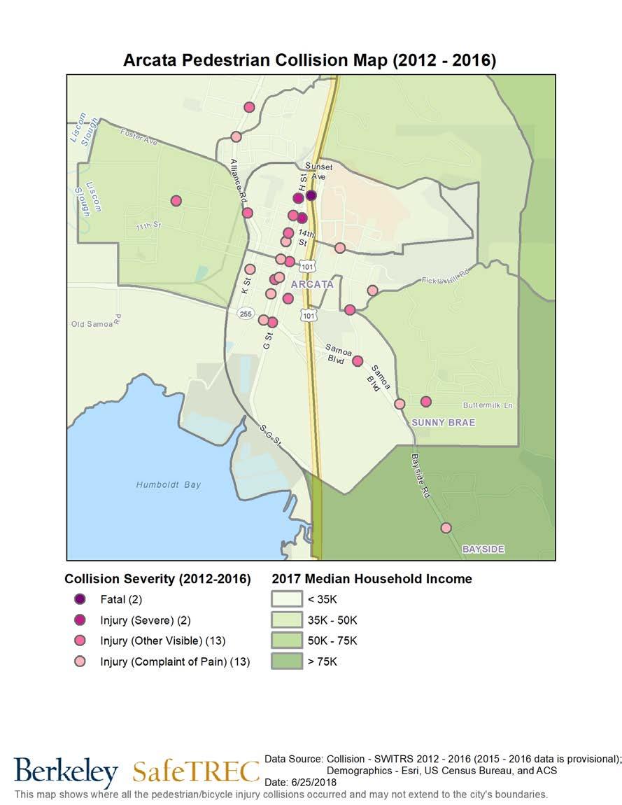
6 walking and bicycle connectivity between the Valley West neighborhood and Downtown Arcata. Site Visit: The Project Team conducted an in-person site visit on May 23, 2018 to 1) collect qualitative data based on in-person observations of existing conditions and travel behaviors and; 2) conduct preliminary walking assessments of the focal neighborhood. The Project Team used the site visit findings to develop the workshop presentation, including featuring local infrastructure examples and developing the walking/biking assessment route maps. Existing Conditions Pedestrian & Bicycle Collision History Between , there were two (2) pedestrian collisions, including one (1) severe injury in Valley West. Collisions in this time period occurred on Giuntoli Lane. Both (100%) pedestrian victims were male. Over the 10-year period between , pedestrian collisions appear to be on an upward trajectory. Pedestrian Collision Trend with 3-year moving average 6
7 Between , there were three (3) bicycle collisions, including three (3) visible injuries in Valley West. Collisions in this time period occurred on Giuntoli Lane. The three (3) bicycle collision victims were male between the ages of Over the 10-year period between , bicycle collisions appear to be on an upward trajectory. Bicycle Collision Trend with 3-year moving average A full discussion of the pedestrian and bicyclist collision data prepared by UC Berkeley SafeTREC can be found in Appendix A. Equity Concerns Nationwide, pedestrian fatality rates in lower-income communities are generally higher sometimes more than twice as high 1 when compared to higher income communities. State funding programs generally define Census tracts at or below 80% of the statewide median household income ($51,026) as disadvantaged communities. Valley West is a predominantly Latino community with a median household income of $35,000 or below according to the U.S. Census Bureau. The community is also geographically separated and isolated from the rest of the City by CA-101 and SR-299 and is one of the lowest income neighborhoods in Arcata where many residents experience homelessness and housing insecurity. Additionally, many residents must travel on foot or by bicycle on a daily basis for transportation. 1 Pedestrian Deaths in Poorer Neighborhoods Report," Governing, August Available at 7
 identify positive community assets and strategies which can be built upon; 4) consider how the walking and biking experience might feel different for other")

8 Walkability & Bikeability Assessment Reflections Participants were asked to 1) observe infrastructure conditions and the behavior of all road users; 2) assess the qualitative and emotional experience of walking or biking along the route; 3) identify positive community assets and strategies which can be built upon; 4) consider how the walking and biking experience might feel different for other vulnerable users. Workshop participants conducted walking and biking assessments along three key routes: Route 1: Giuntoli Lane to West End Road The first assessment route focused on Giuntoli Lane from Valley West Boulevard to West End Road. The route is the main ingress and egress into the Valley West community and used by community members and visitors to access both US State Route 101 (US 101) and California State Route 299 (SR 299) and the shops, gas station, and other amenities along Giuntoli Lane. Starting the walk assessment at the Red Roof Inn, the group of observers walked north on Valley West Boulevard, east on Giuntoli Lane to West End Road, and returned to the Red Roof Inn along Giuntoli Lane. Observations were conducted at several locations along Giuntoli Lane including the Valley East Boulevard, the transit bus stop near the SR 299 onramp, and at West End Road. Route 2 West on Giuntoli Lane to SR 101 to Heindon Road The second assessment route focused on Giuntoli Lane going west to Heindon Road over SR 101. The Planning Committee selected this route due to the numerous crossing challenges at roundabouts the on- and off-ramps of SR 101, particularly for bicyclists. Starting the walking assessment at Red Roof Inn, participants walked north on Valley West Boulevard, then west on Giuntoli Lane crossing the two roundabouts at the SR 101 ramps, and ending at the Giuntoli Lane/Heindon Road intersection before returning to the Red Roof Inn. 8

9 Route 3 Valley West & Valley East The third assessment route focused on Valley West Boulevard and Valley East Boulevard. Starting the walk assessment at Red Roof Inn, this group walked south on Valley West Boulevard, east on Valley East, a slight detour onto Hallen Drive before continuing north on Valley East Boulevard, west on Giuntoli Lane, and south on Valley West Boulevard. 9


10 Following the walking and biking assessment, the participants shared the following reflections: Missing Sidewalks and Various Sidewalk Conditions: Though sidewalks are present on the Valley East and West Boulevard loop, many areas in the community lack sidewalks, most notably, sections of Giuntoli Lane. Participants identified missing sidewalks on Giuntoli Lane from Boyd Road to West End Road; the entire north side of Giuntoli Lane heading west from Valley West Boulevard; and on West End Road south toward Alder Grove Road. Participants also noted that where sidewalks exist, the widths and maintenance conditions of the sidewalks varied throughout the community. Participants on Route 3 noted that the sidewalks along Valley West Boulevard and Valley East Boulevard are narrow and challenging to navigate, particularly for individuals using assisted mobility devices and the elderly. Participants also experienced a number of sidewalk obstructions (e.g., utility poles, overgrown vegetation) and tripping hazards (e.g., large cracks in the sidewalk, gravel) on some segments of sidewalks along Giuntoli Lane and Valley East Boulevard near the Stonebridge Montessori Academy. Workshop participants walk on a dirt path along Giuntoli Road towards West End Road Rough and gravely sidewalks along Giuntoli Lane. 10


11 Additional Roadway and Wayfinding Signage: Participants noted a lack of signage in the community, including pedestrian crossing signage, bicycle lane and bicycle wayfinding signs, and landmark signs identifying the Valley West community. Participants on Route 1 noted a lack of signage and road markings identifying the bike lane along Giuntoli Lane, especially at the SR 299 on- and off- ramps. Workshop participants also identified a need for wayfinding signage to direct bicyclists to nearby destinations such as parks, schools, and nearby trails, similar to wayfinding signage present in other parts of Arcata. Participants on Route 3, for example, were excited to experience Valley West Park for the first time many participants were not aware of the park s location despite living in the neighborhood. Participants also shared that advanced pedestrian crossing warning signage at Boyd Road may help signal to motorists to expect pedestrians in the marked crosswalk on the southside of Giuntoli Road. Playground at Valley West Park at Hallen Drive is not easily found by both residents and non-residents. A bicyclists rides along Guiontoli Lane and Boyd Road where the bicycle lane markings end. Challenging Marked and Unmarked Crossings: Though sidewalks do not exist on Giuntoli Lane or West End Road near the SR 299 on- and off-ramps, participants on Route 1 shared that residents regularly walk in this area. Accordingly, participants expressed that they would feel safer walking in the area with marked crosswalks as a short-term improvement, while the City, County, and Caltrans work toward installing sidewalks in the long-term. Participants on Route 2 appreciated the highvisibility crosswalk at the Heindon Road/Giuntoli Lane intersection but noted that the existing street configuration and markings were not sufficient. The high-visibility crossing that goes across Heindon Road is skewed to accommodate a very wide turning radius for drivers turning right onto Giuntoli Lane, thereby creating a longer crossing distance for pedestrians. Additionally, participants observed that there are no crosswalks across Giuntoli Lane at this intersection that would enable residents to access the regional Hammond Trail and Mad River on foot or by bike. Participants supported the addition of a high-visibility marked crossing across Giuntoli Lane with enhancements, such as pedestrian refuge islands and rectangular rapid flashing beacons to increase the visibility of pedestrians. 11

12 Inadequate Street Lighting: Participants identified limited nighttime visibility for and of pedestrians and bicyclists as a major safety challenge. While the neighborhood has some lighting, most street lights are directed at the roadway and largely illuminate the driving lanes only. In general, the neighborhood lacks pedestrian-scale lighting along most sidewalks, at pedestrian crossing locations, at transit stops, and at Valley West Park. Participants highlighted that the lack of pedestrian-scale and street lighting on Giuntoli Road between Valley West Boulevard and West End Road and the presence of many driveways along Giuntoli Guintoli Lane in the late afternoon, looking west from the transit stop towards CA US 101 has long stretches with limited streetlights. Road are safety barriers that makes it difficult to navigate at night. Participants on Routes 1 and 3 shared that they will not leave their homes or walk at night along Valley West Boulevard and Valley East Boulevard once the sun sets because of the missing street lighting, limited visibility, and fear that they will not be seen by motorists. Challenging Roundabouts for All Users: Participants in Route 2 observed and evaluated two roundabouts that cross SR 101. Participants identified two major challenges with the current roundabouts and user behaviors. When pedestrians cross at the designated marked crosswalks, drivers generally tend to yield the right-of-way to pedestrians. However, this has the unintended consequence of causing drivers to come to a full stop in the roundabout. Because roundabouts are generally designed to facilitate free-moving traffic, drivers are not expecting other drivers to stop in roundabouts, and participants shared that during peak traffic times, many rear-end collisions occur. The second major challenge is related to how a bicyclist is expected to navigate this roundabout. Though a bike lane exists on the south side of Giuntoli Lane, the eastbound bike lane abruptly ends as it approaches the roundabout. Participants deduced that eastbound bicyclists are expected to ride onto an unmarked curb ramp, n navigate on the sidewalk to clear the roundabout, and then descend another unmarked curb ramp to re-merge into traffic. Participants found this design to be confusing and unintuitive for bicyclists and for drivers who may not be expecting bicyclists to merge into traffic from the sidewalk. Moreover, the current roundabout design is inconsistent for westbound bicyclists who must bike along the north side of Giuntoli Lane with no bike lanes and navigate through the roundabout as a driver would. 12


13 Bus Shelters: Not all transit stops in the community have bus shelters to protect riders from the elements, especially during the rainy season. Participants on Route 3 who travel by bus shared that some transit stops are in disrepair with trash adjacent to them and missing lighting and benches. On Route 3, a bus rider was observed sitting on the sidewalk waiting for the bus in front of the former Little Learners Center along Valley East Boulevard. Bus shelter without a bench on Valley East Boulevard. Bus transit user awaits bus on sidewalk due to missing bus bench. Unsafe Road User Behavior: Participants noted a number of unsafe road user behaviors, including drivers traveling at speeds above the posted speed limits and failing to share the road with bicyclists; pedestrians crossing mid-block outside of marked or unmarked crossings; and bicyclists riding on the sidewalk and failing to yield at stop signs and marked crosswalks. On Route 3, participants observed pedestrians walking in the street in the bike lanes and crossing outside of marked and unmarked crosswalks. Participants on all routes also agreed that some drivers traveling along Giuntoli Lane, Valley West Boulevard, and Valley East Boulevard appeared to be traveling above the posted speed limits. Participants shared they do not feel safe crossing the street, even in the marked crosswalks along Valley West due to high vehicle speeds and drivers often failing to yield to pedestrians at marked crosswalks, particularly at Giuntoli Lane/Boyd Road. Pedestrians cross Valley West Boulevard midblock and outside a crosswalk. 13


14 Individuals Experiencing Homelessness and Housing Insecurity: Participants noted that the number of individuals experiencing homelessness is increasing in the community, particularly in empty lots and neighborhood park. Participants shared that community members experience housing insecurity often live in recreational vehicles (RVs) that are parked along the Valley West loop, which limits visibility between motorists, bicyclists, and pedestrians along Valley West Boulevard and Valley East Boulevard. Participants on Route 1 shared that there are Humboldt State University (HSU) students living in the community who are experiencing housing insecurity. As of April 2018, 19% of HSU students reported being housing insecure at least once in the last twelve months. 2 Overgrown Vegetation and Lack of Shade Trees: Participants shared that overgrown bushes and low hanging tree branches block visibility and access for pedestrians using the sidewalk along Giuntoli Lane, Valley West Boulevard, and Valley East Boulevard. Narrow sidewalk with light post and overgrown tree roots creating barriers for pedestrians along Valley West Boulevard (left). Overgrown shrubbery limits walkability along Valley East Boulevard (right). 2 An Unprecedented Look at CSU Students Food and Housing Insecurity. Humboldt State Now. April Accessed September 30,
15 Key Opportunities to Improve Walking and Biking Safety Following the walking and biking assessment, the Project Team facilitated small-group action planning discussions where participants prioritized and preliminarily planned infrastructure projects and community programs aimed at reducing the number of injuries and fatalities, as well as increasing the number of people and the frequency of walking and biking in Valley West. Through a voting process during the training, participants chose to focus on and preliminarily plan for crossing enhancements and temporary demonstrations, a bicycling education campaign, and a neighborhood speed watch program. Participants self-selected which project they wanted to collaborate on with their fellow participants to develop a plan and discussed: The problem the infrastructure project/community program is intended to solve; The people, organizations and agencies that should be involved to implement the infrastructure project/community program; Resources needed to implement the infrastructure project/community program; and Short-term and long-term action steps to implement the infrastructure project/community program. Community Recommendations Workshop participants provided the following priority recommendations and next steps for overall pedestrian and bicyclist safety improvements in the workshop area and throughout the Jackson Academy community. Community Programs, Policies, and Campaigns Bicycle Educational Campaign: Participants were interested in creating a comprehensive bicycle education program targeting youth and their parents, adults, and college students as a means to improve bicyclist behaviors in the community and create a safer environment for bicyclists and drivers. Participants in this group planned to outreach to and partner with the Arcata School District and HSU to create educational materials, such as pamphlets, a service directory, and signage throughout the community for students from K-12, parents, and university students with the premise that bicycling education begins at home and is a valuable life skill. The partnership between the Arcata School District and Humboldt State University envisions HSU students educating youth through presentations, bike rodeos, and group bike rides. In order to see these projects through to fruition, the participants identified the Arcata School District, HSU, Humboldt State University Police, Arcata Police Department, the City of Arcata, local bicycle organizations, local bicycle shops, and parents as key partners for implementation. Participants committed to forming a group of community leaders who conduct outreach to HSU students to participate in the creation of educational tools to distribute in the community and to begin 15
16 organizing presentations, bike rodeos, and group bike rides. Participants hope to form a community group and begin conducting outreach to students and the district by the end of They also hope to develop educational materials and host one bike rodeo within a year of the CPBST. Neighborhood Speed Watch and Education Program: Participants were interested in implementing a neighborhood speed watch and education program utilizing handheld speed radar devices and roadway speed feedback signs as a strategy to reduce high vehicle speeds in the community. Participants identified Giuntoli Lane, Valley West Boulevard, and Valley East Boulevard as the target corridors for the program. The main goals of the program are to increase drivers awareness of how fast they are traveling and to alert drivers when they are traveling at excessive speeds through the use of speed radar devices and warning letters issued by the California Department of Motor Vehicles (DMV) office in Eureka. In order to start the program, participants identified developing relationships with the DMV office in Eureka and the City of Arcata to assess the feasibility of the program and any support the two agencies can offer. Participants expected the program would require volunteers, signage, speed radar devices, and DMV collaboration to being the program and hoped to develop specific educational material to provide drivers. Cal Walks committed to ing the group information on Sacramento County s Neighborhood Speed Watch Program to review and to scheduling a planning call in late October 2018 to discuss the program and identify next steps. Infrastructure Concerns & Priorities Crossing Enhancements and Temporary Demonstrations: Participants were very interested in improving crossings in the neighborhood, particularly at intersections that currently lacked any marked crossings. Participants identified geographic proximity to parks, mobile home parks, bus stops, schools, and commercial developments (e.g. along Valley East Boulevard) as criteria for prioritizing the installation of new crosswalks. Additionally, this group identified some specific locations that sorely needed marked crosswalks, including all legs of the Wymore Road/Valley West Boulevard/Giuntoli Lane intersection and across Giuntoli Lane at the intersections east of Valley East Boulevard. Participants identified the key stakeholders for implementing these crossing enhancements as the City of Arcata, Humboldt County, Caltrans District 1, Humboldt County Public Health, residents, and local businesses. In particular, participants noted that residents will be crucial for collecting qualitative safety data to help in the prioritization of new crosswalk locations and enhancements. Additionally, improved interagency communications between the City, Count, and Caltrans will help streamline implementation of the crosswalk enhancements. In terms of specific crosswalk enhancements, participants voiced support not only for high-visibility crosswalk markings, pedestrian-scale lighting, rectangular rapid flashing beacons, and fluorescent crossing signage but also for more greening and aesthetic-focused safety improvements, such as landscaped medians that could also serve as pedestrian refuge islands. 16
17 Recognizing that many of these improvements will require a longer time frame to implement, this group also discussed hosting a temporary demonstration of crossing enhancements in May 2019 as a way to build momentum and sustain engagement with residents. The group identified the need for establishing a project team to oversee the temporary demonstration and set a goal of October/November 2018 to recruit project team members, as well as to gauge interest from City staff, particularly from the Public Works Department. Participants also discussed the importance of evaluating before and after conditions with the temporary demonstrations to measure success and impact on pedestrian and bicycle safety. The group also identified the following preliminary tasks that would need to be completed but left the target completion dates to be determined by the project team: o Identify location(s), dates, and times for demonstration(s); o Secure donations for the event, including spray paint, hay bales, traffic safety cones, chalk, webcam or GoPro camera; o Recruit volunteers to help set up demonstration(s), conduct outreach, and assist with traffic control and evaluation activities; o Promote demonstration event(s); o Secure permit(s) and/or permit fee waivers from City or County as needed; and o Develop evaluation plan and/or survey for before and after data collection, including, but not limited to, driver speeds, number of people walking, number of people crossing and driver yield rates to pedestrians crossing. Cal Walks/SafeTREC Recommendations California Walks and SafeTREC also submit the following recommendations for consideration by the Planning Committee: Expand Zagster Bikeshare to the Valley West Neighborhood: Participants during the workshop repeatedly communicated that Valley West neighborhood is isolated from the rest of the City and feltthat many Arcata residents do not view Valley West as part of the larger Arcata community. The Project Team recommends that the City of Arcata explore the feasibility of expanding the existing Zagster Bikeshare system to the Valley West Neighborhood. Expansion of the current bikeshare system beyond its current focus around HSU and Downtown Arcata can help to foster a shared sense of community identity, while also encouraging more travel between Valley West and the other neighborhoods of Arcata. Given the lower-income and demographics of the Valley West neighborhood, any expansion of the system would require Spanish-language outreach and educational materials and include proactive strategies to enable people with low incomes, without credit cards, and with old or no smartphones to be able to access the system. Potential strategies that may work in Valley West that have been implemented in other bikeshare systems include: 17
18 o Reduced fares or membership discounts for residents receiving state welfare or other assistance; o Enabling access to the system with cash payments that can be loaded onto membership cards in person; and o Enabling access to the system via text message to unlock a bike, ride, and end a trips. This strategy would enable riders without smartphones to be able to fully use the bikeshare system. Lighting Assessment: The Project Team encourages and recommends the Planning Committee and workshop participants to collaboratively conduct a community-wide street lighting assessment focused on pedestrian and bicycle lighting needs around Giuntoli Lane, Valley West Boulevard, Valley East Boulevard, and Valley West Park. Proper street lights provide safety and security as well as improve the overall well-being of road users. A lighting assessment can be used to identify and inventory nighttime pedestrian-scale lighting needs in areas of high nighttime pedestrian activity. A nighttime assessment will also identify lighting fixtures in need of repair or replacement, and with an inventory, the City can develop a proactive and equitable plan for streetlight maintenance that is not complaint-driven. Lighting should be uniform and consistent to increase visibility. Valley West Park Wayfinding and Additional Signage: Residents participating in the workshop were unaware of Valley West Park, a linear park located along Valley East Boulevard behind the apartment complexes from Poplar Drive to Valley West Boulevard and bisected by Hallen Drive. The park has a community playground along Hallen Drive. Although the park is listed on the City of Arcata, Arcata Parks and Playground map, participants did not see any entrance signage identifying the park. The Project Team recommends the addition of an entrance sign at Hallen Drive near the park parking lot (at Poplar Drive) and interpretative signage explaining the park floods during rainy season. Participants shared that while the playground can be used yearround, some portions of the park flood. The Project Team also recommends the City explore the possibility of adding a trail or sidewalk through the park to allow residents a safe, comfortable and pleasant place to walk. Several older residents shared they walk regularly in the community and would like to have additional places to walk away from vehicle traffic. 18
19 Appendix A Pedestrian and Bicycle Collision Data Analysis Workshop Handout 19


20 ARCATA VALLEY WEST DATA ANALYSES Community Pedestrian and Bicycle Safety Training Workshop August 29, 2018 The goal of the Community Pedestrian and Bicycle Safety Training (CPBST) is to make communities safer and more pleasant for walking and bicycling. This workshop will train local residents and safety advocates in pedestrian and bicycle safety as well as create opportunities for collaboration with local officials and agency staff. This fact sheet highlights some of the most recent pedestrian and bicycle collision data available for Arcata Valley West to help the community better prioritize recommendations that emerge from this workshop. PEDESTRIANS 4 people were injured in 4 pedestrian collisions in the last 10 years ( ). The three-year moving average line shows an upward trend in pedestrian collisions.* There were 0 pedestrian collisions in 2016, but an average of 2 pedestrian collisions per year for the 3-year rolling average between 2015 and *This line is useful for tracking change over time, especially when the number of collisions changes a lot between years. Data points are at the midpoint of the three years of data specified. 100% driver violations VS. 0% pedestrian violations * Note: There were only 2 collisions in the last 5 years ( ) % of victims were male 50.0% of victims (or 1 person) was SEVERELY INJURED Data Source: California Statewide Integrated Traffic Records System (SWITRS). Collision data for 2016 and 2017 are provisional at this time. Funding for this program was provided by a grant from the California Office of Traffic Safety through the National Highway Traffic Safety Administration.


21 5 people were killed or injured in 5 bicycle collisions in the last 10 years ( ). BICYCLES The three-year moving average line shows no change in bicycle collisions.* There were 2 bicycle collisions in 2016, but an average of 1 bicycle collisions per year for the 3-year rolling average between 2015 and * This line is useful for tracking change over time, especially when the number of collisions changes a lot between years. Data points are at the midpoint of the three years of data specified. Bicycles must follow all the same rules of the road as vehicles. As a result, we cannot break down violations by driver vs. bicyclist % of victims were male 100.0% of victims were age % of victims (or 3 people) had MINOR INJURIES SUMMARY 37.8 pedestrian fatalities & injuries per 100,000 population over the last five years, which is 15.6% less than Humboldt County and 5.3% more than California Yearly Population Rate of Fatalities & Injuries per 100,000 Population Calculated Over a 5-year Period* Pedestrian Bicyclist Arcata bicyclist fatalities & injuries per 100,000 population over the last five years, which is 65.1% more than Humboldt County and 80.5% more than California Humboldt California Source: U.S. Census Bureau, Population Division (intercensal population data for 2016). * The rate per population is calculated by adding the number of fatalities and injuries from 2012 to 2016 divided by five times the population in CALIFORNIA OFFICE OF TRAFFIC SAFETY
22 Pedestrian Collisions collisions mapped in the Valley West area of Arcata, CA. Data Source: California Statewide Initegrated Traffic Records System (SWITRS). Collision data for 2016 and 2017 are provisional.
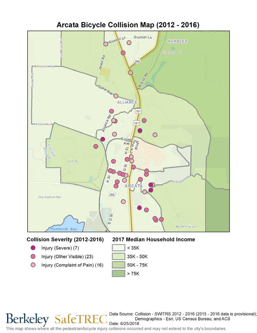
23 Bicyclist collision locations, collisions mapped in the Valley West area of Arcata, CA. Data Source: California Statewide Initegrated Traffic Records System (SWITRS). Collision data for 2016 and 2017 are provisional.
24 Appendix B Pedestrian and Bicycle Collision Data Analysis Site Visit Presentation 24
25 Community Pedestrian and Bicycle Safety Workshop - Data Arcata, CA 6/27/18 Pedestrian Injury Collision Trend with 3-year moving average Source: Statewide Integrated Traffic Records System (SWITRS), ; 2015 and 2016 SWITRS are provisional as of November 2017.

26 Pedestrian Injury Collisions Only 30 of 34 collisions are mapped. Source: SWITRS, ; 2015 and 2016 SWITRS are provisional as of November 2017.
27

28 Pedestrian Injury Collisions by Time of Day and Day of Week Total: 34 collisions *The colors in this graph refer to how frequently a collision occurs at that time & day. Top Violations in Pedestrian Injury Collisions CVC No. Description No. % Driver failure to yield right-of-way to pedestrians at a crosswalk % 0 Unknown % Pedestrian failure to yield right-of-way to vehicles 3 8.8% Unsafe turning with or without signaling 2 5.9% Speeding on the highway 2 5.9% Total: 34 collisions Unsafe starting or backing of vehicle 2 5.9% Drving under the influence of alcohol 2 5.9% Pedestrian failure to walk close to the edge of the roadway when there is no sidewalk present 1 2.9% Failure of motorized scooter operator 1 2.9% Total %
29 Pedestrian Victim Injury Severity Source: SWITRS, ; 2015 and 2016 SWITRS are provisional as of November 2017.
30 Pedestrian Victims by Age and Gender Source: SWITRS, ; 2015 and 2016 SWITRS are provisional as of November 2017.

31 Bicycle Injury Collision Trend with 3-year moving average Source: SWITRS, ; 2015 and 2016 SWITRS are provisional as of November 2017.
32 Bicycle Injury Collisions Only 48 of 53 collisions are mapped. Source: SWITRS, ; 2015 and 2016 SWITRS are provisional as of November 2017.
33

34 Bicycle Injury Collisions by Time of Day and Day of Week Total: 53 collisions *The colors in this graph refer to how frequently a collision occurs at that time & day. Top Violations in Bicycle Injury Collisions CVC No. Description No. % Speeding on the highway % 0 Unknown % Unsafe turning with or without signaling % Bicyclist failure to follow same rights and laws on the road as drivers 5 9.4% Failure to drive/ride on right half of the roadway (with some exceptions) 4 7.5% Driver failure to stop at a limit line or crosswalk at a stop sign 4 7.5% Failure to yield right-of-way at intersection 3 5.7% Failure to stop or yield right-of-way at a stop sign % Bicyclist failure to ride on right edge of roadway if riding below the normal speed of traffic 2 3.8% Driver failure to pass bicyclists under safe conditions 2 3.8% Total %

35 Bicycle Victim Injury Severity Source: SWITRS, ; 2015 and 2016 SWITRS are provisional as of November 2017.
36 Bicycle Victims by Age and Gender Source: SWITRS, ; 2015 and 2016 SWITRS are provisional as of November 2017.


37 Laurel Tree Charter 4555 Valley West Blvd Arcata Humboldt County CDS:
. To further explore collision data, register for a free account to access the tools and resources on TIMS. https://tims.berkeley.")
38 The Transportation Injury Mapping System (TIMS) is a web-based tool that allows users to analyze and map data from California's Statewide Integrated Traffic Records System (SWITRS). To further explore collision data, register for a free account to access the tools and resources on TIMS. Berkeley SafeTREC
Recommendations to Improve Pedestrian & Bicycle Safety for the Zane Middle School Community
 Recommendations to Improve Pedestrian & Bicycle Safety for the Zane Middle School Community October 2018 1 Acknowledgements Planning Committee Nicole Sager Jesse Willor Jenny Weiss Emily Sinkhorn Scott
Recommendations to Improve Pedestrian & Bicycle Safety for the Missouri Flat Area (El Dorado County)
") Recommendations to Improve Pedestrian & Bicycle Safety for the Missouri Flat Area (El Dorado County) October 2017 Recommendations to Improve Pedestrian & Bicycle Safety for the Missouri Flat Area (El Dorado
Recommendations to Improve Pedestrian & Bicycle Safety for the Missouri Flat Area (El Dorado County) October 2017 Recommendations to Improve Pedestrian & Bicycle Safety for the Missouri Flat Area (El Dorado
Recommendations to Improve Pedestrian & Bicycle Safety for the Arden-Arcade Community
 Recommendations to Improve Pedestrian & Bicycle Safety for the Arden-Arcade Community June 2018 Acknowledgements Planning Committee Joelle Orrock Gail Kelly Molly Patterson Dan Allison Heather Yee Molly
Recommendations to Improve Pedestrian & Bicycle Safety in the Azusa Unified School District
 Recommendations to Improve Pedestrian & Bicycle Safety in the Azusa Unified School District October 2017 Recommendations to Improve Pedestrian & Bicycle Safety in the Azusa Unified School District By Mihaela
Recommendations to Improve Pedestrian & Bicycle Safety for the City of Arvin
 Recommendations to Improve Pedestrian & Bicycle Safety for the City of Arvin July 2018 1 Acknowledgements Planning Committee Jack Becker Tammy Fisher Pat Ebel Peter Smith Carlos Bello Christine Viterelli
Recommendations to Improve Pedestrian & Bicycle Safety for the City of Hayward: Tennyson Road Corridor
 Recommendations to Improve Pedestrian & Bicycle Safety for the City of Hayward: Tennyson Road Corridor October 2018 1 Acknowledgments Planning Committee Charmine Solla Steven Chang Patty Garcia Sergio
Recommendations to Improve Pedestrian & Bicycle Safety for the City of Lemon Grove
 Recommendations to Improve Pedestrian & Bicycle Safety for the City of Lemon Grove October 2018 1 Acknowledgements Planning Committee Anita Lopez Rosa Carney Steve Browne Angeles Nelson Lemon Grove Healthy
RECOMMENDATIONS TO IMPROVE PEDESTRIAN & BICYCLE SAFETY IN THE COMMUNITY OF FLORENCE-FIRESTONE
 RECOMMENDATIONS TO IMPROVE PEDESTRIAN & BICYCLE SAFETY IN THE COMMUNITY OF FLORENCE-FIRESTONE September 2017 By Miha Tomuta, Wendy Ortiz, California Walks; Jill Cooper, Katherine Chen, UC Berkeley SafeTREC
Recommendations to Improve Pedestrian & Bicycle Safety for the Clegg Elementary School & Stacey Middle School Community
 Recommendations to Improve Pedestrian & Bicycle Safety for the Clegg Elementary School & Stacey Middle School Community (Westminster School District) October 2018 1 Acknowledgements Planning Committee
Recommendations to Improve Pedestrian & Bicycle Safety for the Community of Palermo
 Recommendations to Improve Pedestrian & Bicycle Safety for the Community of Palermo September 2017 Recommendations to Improve Pedestrian & Bicycle Safety for the Community of Palermo By Wendy Ortiz, Jaime
Recommendations to Improve Pedestrian & Bicycle Safety for the City of Bakersfield
 Recommendations to Improve Pedestrian & Bicycle Safety for the City of Bakersfield August 2018 1 Acknowledgements Planning Committee Jack Becker Bike Bakersfield Cindy Parra Bike Bakersfield Christopher
Recommendations to Improve Pedestrian & Bicycle Safety for the Community of North Shore
 Recommendations to Improve Pedestrian & Bicycle Safety for the Community of North Shore October 2017 Recommendations to Improve Pedestrian & Bicycle Safety for the Community of North Shore By Tony Dang,
PEDESTRIAN ACTION PLAN
 ATTACHMENT 2 CITY OF SANTA MONICA PEDESTRIAN ACTION PLAN CITY OF SANTA MONICA PEDESTRIAN ACTION PLAN This page intentionally left blank EXECUTIVE SUMMARY CHAPTER 1 EXECUTIVE SUMMARY Setting the Stage
Recommendations to Improve Pedestrian & Bicycle Safety for the Community of Southwest Fresno
 Recommendations to Improve Pedestrian & Bicycle Safety for the Community of Southwest Fresno October 2017 Recommendations to Improve Pedestrian & Bicycle Safety for the Community of Southwest Fresno By
Chapter 14 PARLIER RELATIONSHIP TO CITY PLANS AND POLICIES. Recommendations to Improve Pedestrian Safety in the City of Parlier (2014)
") Chapter 14 PARLIER This chapter describes the current status and future plans for biking and walking in the City of Parlier. RELATIONSHIP TO CITY PLANS AND POLICIES The Parlier General Plan is the primary
Chapter 14 PARLIER This chapter describes the current status and future plans for biking and walking in the City of Parlier. RELATIONSHIP TO CITY PLANS AND POLICIES The Parlier General Plan is the primary
Chapter 2. Bellingham Bicycle Master Plan Chapter 2: Policies and Actions
 Chapter 2 Bellingham Bicycle Master Plan Chapter 2: Policies and Actions Chapter 2: Policies and Actions The Bicycle Master Plan provides a road map for making bicycling in Bellingham a viable transportation
APPENDIX A: Complete Streets Checklist DRAFT NOVEMBER 2016
 APPENDIX A: Complete Streets Checklist DRAFT NOVEMBER 2016 Complete Streets Checklist MetroPlan Orlando s Complete Streets Checklist is an internal planning tool for staff to further implementation of
Proposed. City of Grand Junction Complete Streets Policy. Exhibit 10
 Proposed City of Grand Junction Complete Streets Policy Exhibit 10 1 City of Grand Junction Complete Streets Policy Vision: The Complete Streets Vision is to develop a safe, efficient, and reliable travel
RECOMMENDATIONS TO IMPROVE PEDESTRIAN SAFETY IN MCKINLEYVILLE
 RECOMMENDATIONS TO IMPROVE PEDESTRIAN SAFETY IN MCKINLEYVILLE May 2015 By Tony Dang, Jaime Fearer, Wendy Alfsen, California Walks; Jill Cooper, UC Berkeley SafeTREC Recommendations to Improve Pedestrian
CHAPTER 3: Vision Statement and Goals
 Davidson Walks & Rolls: Active Transportation Master Plan CHAPTER 3 Contents: Overview Vision Statement Measurable Goals Public Outreach CHAPTER 3: Vision Statement and Goals Overview The vision statement
Agenda. Overview PRINCE GEORGE S PLAZA METRO AREA PEDESTRIAN PLAN
 PRINCE GEORGE S PLAZA METRO AREA PEDESTRIAN PLAN May 28, 2008 Agenda Welcome and introductions Project overview and issue identification Planning context and strengths Design challenges and initial recommendations
Appendix A: Crosswalk Policy
 Appendix A: Crosswalk Policy Appendix A: Crosswalk Policy Introduction This citywide Crosswalk Policy is aimed at improving pedestrian safety and enhancing pedestrian mobility by providing a framework
Living Streets Policy
 Living Streets Policy Introduction Living streets balance the needs of motorists, bicyclists, pedestrians and transit riders in ways that promote safety and convenience, enhance community identity, create
City of Novi Non-Motorized Master Plan 2011 Executive Summary
 City of Novi Non-Motorized Master Plan 2011 Executive Summary Prepared by: February 28, 2011 Why Plan? Encouraging healthy, active lifestyles through pathway and sidewalk connectivity has been a focus
Bikeway action plan. Bicycle Friendly Community Workshop March 5, 2007 Rochester, MN
 Bikeway action plan Summary The was held on March 5, 2007 at the Rochester Mayo Civic Center. The workshop was hosted by Rochester-Olmsted County Planning Department in collaboration with the League of
RECOMMENDATIONS TO IMPROVE PEDESTRIAN & BICYCLIST SAFETY FOR THE MOUNTAIN VIEW SCHOOL DISTRICT (EL MONTE/SOUTH EL MONTE)
") RECOMMENDATIONS TO IMPROVE PEDESTRIAN & BICYCLIST SAFETY FOR THE MOUNTAIN VIEW SCHOOL DISTRICT (EL MONTE/SOUTH EL MONTE) August 2016 By Caro Jauregui, Jaime Fearer, Tony Dang, Wendy Alfsen California Walks;
RECOMMENDATIONS TO IMPROVE PEDESTRIAN & BICYCLIST SAFETY FOR THE MOUNTAIN VIEW SCHOOL DISTRICT (EL MONTE/SOUTH EL MONTE) August 2016 By Caro Jauregui, Jaime Fearer, Tony Dang, Wendy Alfsen California Walks;
City of San Diego Vision Zero Draft Strategic Plan FY 2017
 City of San Diego Vision Zero Draft Strategic Plan FY 2017 Engineering Objective: To develop and implement a strategy that employs best planning, design and engineering practices. Background: Over the
o n - m o t o r i z e d transportation is an overlooked element that can greatly enhance the overall quality of life for the community s residents.
 N o n - m o t o r i z e d transportation is an overlooked element that can greatly enhance the overall quality of life for the community s residents. 84 Transportation CHAPTER 11 INTRODUCTION Transportation
Appendix E: Bike Crash Analysis ( )
") Appendix E: Bike Crash Analysis (2009-2012) Davis Bicycle Crashes Analysis 2009-2012 December 2013 Ride Walk Davis Active Transportation Program City of Davis December 2013 Prepared by: Jimmy Fong Active
Appendix E: Bike Crash Analysis (2009-2012) Davis Bicycle Crashes Analysis 2009-2012 December 2013 Ride Walk Davis Active Transportation Program City of Davis December 2013 Prepared by: Jimmy Fong Active
RECOMMENDATIONS TO IMPROVE PEDESTRIAN & BICYCLIST SAFETY IN LOS ANGELES CHINATOWN
 RECOMMENDATIONS TO IMPROVE PEDESTRIAN & BICYCLIST SAFETY IN LOS ANGELES CHINATOWN October 2016 By Tony Dang, Caro Jauregui, Jaime Fearer, Wendy Alfsen, California Walks; Jill Cooper, Katherine Chen, UC
CRESTON ROAD COMPLETE AND SUSTAINABLE STREETS CORRIDOR PLAN
 CRESTON ROAD COMPLETE AND SUSTAINABLE STREETS CORRIDOR PLAN Preferred Plan Community Presentation September 27, 2017 City of El Paso de Robles in partnership with: Local Government Commission, W-Trans,
RECOMMENDATIONS TO IMPROVE PEDESTRIAN & BICYCLE SAFETY IN ROSEMONT
 RECOMMENDATIONS TO IMPROVE PEDESTRIAN & BICYCLE SAFETY IN ROSEMONT SEPT 2017 By Tony Dang, Jaime Fearer, Miha Tomuta, Wendy Ortiz, California Walks; Jill Cooper, Jessica Rosas, UC Berkeley SafeTREC Recommendations
MASTER BICYCLE AND PEDESTRIAN PLAN
 VILLAGE OF NORTHBROOK MASTER BICYCLE AND PEDESTRIAN PLAN DRAFT PLAN OPEN HOUSE May 2, 2018 AGENDA 1. Community Engagement 2. Vision and Goals 3. General Structure of Plan 4. Recommendations Overview 5.
CONNECTING PEOPLE TO PLACES
 CONNECTING PEOPLE TO PLACES 82 EAST BENCH MASTER PLAN 07 Introduction The East Bench transportation system is a collection of slow moving, treelined residential streets and major arteries that are the
AGENDA ITEM NO. 5b HCAOG TAC meeting of May 8, 2014
 Humboldt County Association of Governments Eureka, CA, 95501 AGENDA ITEM NO. 5b HCAOG TAC meeting of May 8, 2014 DATE: May 1, 2014 TO: HCAOG Technical Advisory Committee (TAC) FROM:, SUBJECT: Letters of
Pedestrian Project List and Prioritization
 To: Kyle Wagenschutz, City of Memphis CC: From: Anne Conlon and John Cock, Alta Planning + Design Date: December, 2014 Re: Project List Development (Task 3.1-3.2) and Project List Prioritization (Task
Perryville TOD and Greenway Plan
 Perryville TOD and Greenway Plan Greenway Glossary Pathway: A bicycle and pedestrian path separated from motorized vehicular traffic by an open space, barrier or curb. Multi-use paths may be within the
Chapter 2: Standards for Access, Non-Motorized, and Transit
 Standards for Access, Non-Motorized, and Transit Chapter 2: Standards for Access, Non-Motorized, and Transit The Washtenaw County Access Management Plan was developed based on the analysis of existing
Lee s Summit Road Improvement Study Public Open House June 7, 2007 Summary of Comment Card Responses
 Lee s Summit Road Improvement Study Public Open House June 7, 2007 Summary of Comment Card Responses Introduction At the Lee s Summit Road Improvement Study Public Open House held Thursday, June 7, 2007
SAFE ROUTES TO SCHOOL
 SAFE ROUTES TO SCHOOL Forest Ridge Elementary School Existing Conditions and ACTION PLAN > Oak Creek - Franklin Joint School District Table of Contents CONTEXT Enrollment Boundaries
FHWA Resources for Pedestrian and Bicycle Professionals
 FHWA Resources for Pedestrian and Bicycle Professionals Charlie Zegeer, UNC Highway Safety Research Center/PBIC Libby Thomas, UNC Highway Safety Research Center Dan Nabors, Vanasse Hangen Brustlin (VHB)
NJDOT Complete Streets Checklist
 Background The New Jersey Department of Transportation s Complete Streets Policy promotes a comprehensive, integrated, connected multi-modal network by providing connections to bicycling and walking trip
PRINCE GEORGE S PLAZA METRO AREA PEDESTRIAN PLAN
 PRINCE GEORGE S PLAZA METRO AREA PEDESTRIAN PLAN May 28, 2008 Agenda Welcome and introductions Project overview and issue identification Planning context and strengths Design challenges and initial recommendations
Focus on Enforcement. 7/21/2017 Presentation to SFMTA Policy & Governance Committee. Joe Lapka Corina Monzón
 Focus on Enforcement Insights from research and analysis in support of San Francisco s Vision Zero plan to eliminate traffic deaths Joe Lapka Corina Monzón 7/21/2017 Presentation to SFMTA Policy & Governance
Broad Street Bicycle Boulevard Design Guidelines
 Broad Street Bicycle Boulevard Design Guidelines Building from the strategies introduced in the 2013 Bicycle Transportation Plan and community input received thus far, City Transportation Staff have identified
SAN FRANCISCO MUNICIPAL TRANSPORTATION AGENCY
 THIS PRINT COVERS CALENDAR ITEM NO. : 10.2 DIVISION: Sustainable Streets BRIEF DESCRIPTION: SAN FRANCISCO MUNICIPAL TRANSPORTATION AGENCY Adopting Conceptual Proposal for Streetscape Improvements to Broadway,
Chapter 13 ORANGE COVE
 Chapter 13 ORANGE COVE This chapter describes the current status and future plans for biking and walking in the City of Orange Cove. RELATIONSHIP TO CITY PLANS AND POLICIES The Orange Cove General Plan
DRAFT MOVING FORWARD RHODE ISLAND BICYCLE MOBILITY PLAN 2018 PREPARED FOR PREPARED BY IN ASSOCIATION WITH
 RHODE ISLAND MOVING FORWARD BICYCLE MOBILITY PLAN 2018 PREPARED FOR PREPARED BY IN ASSOCIATION WITH T AF CHAPTER 1 D R INTRODUCTION CHAPTER 3 ARTICULATES VISION Bicycling is safe, fun and practical in
IMPLEMENTATION CHAPTER Identifying Priorities 7.2 Maintenance 7.3 Funding 7.4 Education and Enforcement IMPLEMENTATION
 CHAPTER 7.0 IMPLEMENTATION 7.1 Identifying Priorities 7.2 Maintenance 7.3 Funding 7.4 Education and Enforcement IMPLEMENTATION Achieving the vision of the Better Streets Plan will rely on the ability to
2014/2015 BIKE ROUTE PLAN 83 AVENUE PROTECTED BIKE LANE
 About the Project The City of Edmonton is planning a major bike route on the southside of Edmonton. The Strathcona Bike Route will connect the communities of Strathcona, Garneau and the University area,
City of Davis East Covell Corridor Plan
 Community Open House #2 January 22, 2014 6:00 8:00 p.m. Veterans Memorial Center, Club Room City of Davis Introduction The (ECCP) is a taking a comprehensive look at the existing transportation systems
Transportation Planning Division
 Transportation Planning Division Presentation Outline Study Tasks Recap of Previous Meetings Data Collected Focus Areas within Study Limits Design Principles Tool Box Recommended Concepts Schedule Moving
8. Collisions INTRODUCTION
 8. Collisions INTRODUCTION While traffic collisions can affect anyone, they have a disproportionate impact on bicyclists, who along with pedestrians are the most vulnerable users of the transportation
Corpus Christi Metropolitan Transportation Plan Fiscal Year Introduction:
 Introduction: The Safe, Accountable, Flexible, Efficient Transportation Equity Act: A Legacy for Users (SAFETEA-LU) has continued the efforts started through the Intermodal Surface Transportation Efficiency
Vision Zero Task Force February 28, Collision Landscape Analysis
 Vision Zero Task Force February 28, 2017 Collision Landscape Analysis Welcome! What happened since our last Task Force meeting: City Council adopted the Vision Zero Resolution Applied for an OTS grant
AMENDING MOTION: Mobility Plan - Pedestrians and Disadvantaged Communities
 I MOVE that the Council: AMENDING MOTION: Mobility Plan - Pedestrians and Disadvantaged Communities 1. INSTRUCT the Department of City Planning to amend the proposed Mobility Plan to include the following;
Why Zone In on Speed Reduction?
 Learn it. Do it. Live it! SPEED REDUCTION IN THE ZONE Why Zone In on Speed Reduction? Speeding is a serious issue that plays a major role in the risk of serious injury and pedestrian fatality in a crash.
2014/2015 BIKE ROUTE PLAN 83 AVENUE PROTECTED BIKE LANE
 About the Project 2014/2015 BIKE ROUTE PLAN The City of Edmonton is planning a major bike route on the south side of Edmonton. This bike route is one part of a plan to provide citizens with transportation
Ocean Park Boulevard Green Street Project Alternatives & Trade Offs
 Planning Commission March 4, 2009 Ocean Park Boulevard Green Street Project Alternatives & Trade Offs Purpose of Tonight s Meeting Review concept plans and options Provide input on alternatives and trade-offs
BETHEL ROAD AND SEDGWICK ROAD CORRIDOR STUDY
 DRAFT PLAN City Council Meeting August 14, 2017 STUDY AREA Sedgwick Corridor State Route 160, principal arterial with Class 3 access management designation, commuter and freight route, connection to SR
Focus on Enforcement. 3/14/2017 Presentation to the Vision Zero Taskforce. Joe Lapka Corina Monzón
 Focus on Enforcement Insights from research and analysis in support of San Francisco s Vision Zero plan to eliminate traffic deaths Joe Lapka Corina Monzón 3/14/2017 Presentation to the Vision Zero Taskforce
ABOUT THIS STUDY The Tenderloin-Little Saigon Community-Based Transportation Plan
 ABOUT THIS STUDY The Tenderloin-Little Saigon Community-Based Transportation Plan The Greater Tenderloin Community Study Milestones October Community based organizations (Tenderloin Housing Clinic and
Bicycle Master Plan Goals, Strategies, and Policies
 Bicycle Master Plan Goals, Strategies, and Policies Mobilizing 5 This chapter outlines the overarching goals, action statements, and action items Long Beach will take in order to achieve its vision of
BIKE PLAN CONTENTS GATEWAY
 CONTENTS Acknowledgments...vii Great Rivers Greenway District Board of Directors... vii Great Rivers Greenway District Staff... vii Project Consultants... vii Committees... viii Citizens Advisory Committee
Executive Summary Route 30 Corridor Master Plan
 Route Corridor Master Plan Project Overview The Route Corridor Master Plan is a coordinated multimodal transportation and land use plan for the entire stretch of Route through East Whiteland Township,
Safe Routes to School Action Plan Aberdeen, Idaho
 Background Aberdeen, Idaho is a largely agricultural community of nearly 2,000 people and is located in the southeast portion of the state on the western edge of American Falls Reservoir. The community
Chapter VISION, MISSION, AND GOALS AND OBJECTIVES. Vision. Mission. Goals and Objectives CONNECTING COMMUNITIES ACROSS THE ST.
 VISION, MISSION, AND GOALS AND OBJECTIVES Chapter 3 The Plan s vision, mission, and goals and objectives were developed through a series of interactive exercises with the Citizens Advisory Committee (CAC)
Active Transportation Facility Glossary
 Active Transportation Facility Glossary This document defines different active transportation facilities and suggests appropriate corridor types. Click on a facility type to jump to its definition. Bike
Bicycle Boulevards and Neighborhood Greenways
 Bicycle Boulevards and Neighborhood Greenways Traffic Safety is Improving for Everyone 90 80 70 60 50 40 30 20 10 0 PORTLAND: TOTAL TRAFFIC FATALITIES 1986-2008 1986 1987 1988 1989 1990 1991 1992 1993
I-105 Corridor Sustainability Study (CSS)
") I-105 Corridor Sustainability Study (CSS) Metro Streets and Freeways Subcommittee March 21, 2019 Gary Hamrick Cambridge Systematics, Inc. I-105 CSS Project History & Background Funded by Caltrans Sustainable
I-105 Corridor Sustainability Study (CSS) Metro Streets and Freeways Subcommittee March 21, 2019 Gary Hamrick Cambridge Systematics, Inc. I-105 CSS Project History & Background Funded by Caltrans Sustainable
FLETCHER AVENUE PEDESTRIAN AND BICYCLIST BEHAVIOR CHANGE FORMATIVE RESEARCH PROJECT
 FLETCHER AVENUE PEDESTRIAN AND BICYCLIST BEHAVIOR CHANGE FORMATIVE RESEARCH PROJECT EXTENT OF CHANGES IN PEDESTRIAN AND BICYCLIST ATTITUDES AND BEHAVIORS DIRECTLY AFTER A COMPLETE STREETS PROJECT IN FLORIDA
Bicycle and Pedestrian Advisory Committee (BPAC) November 21, 2013
 November 21, 2013") Bicycle and Pedestrian Advisory Committee (BPAC) November 21, 2013 OVERALL LAND USE CONCEPT Overall Broadway Valdez District: 95.5 acres (35.1 acres right-of ways + 60.4 acres developable land) Plan Subareas:
Bicycle and Pedestrian Advisory Committee (BPAC) November 21, 2013 OVERALL LAND USE CONCEPT Overall Broadway Valdez District: 95.5 acres (35.1 acres right-of ways + 60.4 acres developable land) Plan Subareas:
FINAL PLAN APPENDIX D CITY OF BERKELEY BIKE PLAN D-1
 CITY OF BERKELEY BIKE PLAN D-1 . Proposed Programs D.1. EDUCATION This appendix presents the recommended bicycle-related programs for the City of Berkeley. The recommendations are organized in four E s:
UPDATES, SUCCESSES, AND WHAT S AHEAD ON THE ROAD TO ZERO
 Vol. 1, Issue 1 I Spring 2018 www.planhillsborough.org/vision-zero S A F E S T R E E T S N O W H I L L S B O R O U G H UPDATES, SUCCESSES, AND WHAT S AHEAD ON THE ROAD TO ZERO TRACKING PROGRESS This is
1.0 EXECUTIVE SUMMARY
 1.0 EXECUTIVE SUMMARY The Active Transportation Plan is a guide to accomplish the Town s vision for developing a network of sidewalks, on-road bicycle facilities, and trails that allow for safe and convenient
US 278 Corridor Concept Presentation. Avondale Estates Intersection Improvement/Roundabout and Road Diet Feasibility Study March 19, 2015
 US 278 Corridor Concept Presentation Avondale Estates Intersection Improvement/Roundabout and Road Diet Feasibility Study March 19, 2015 Thanks to our Partners Atlanta Regional Commission Georgia Department
CITY OF OAK CREEK SAFE ROUTES TO SCHOOL ACTION PLAN. East Middle School
 CITY OF OAK CREEK SAFE ROUTES TO SCHOOL ACTION PLAN East Middle School CITY OF OAK CREEK SAFE ROUTES TO SCHOOL ACTION PLAN East Middle School Why Safe Routes to School? Safe Routes to School ( SRTS ) is
11/28/2016 VIA
 11/28/2016 VIA EMAIL Ethan Meltzer, Assistant Planner City of Sacramento Community Development Department 300 Richards Blvd., 3 rd Floor Sacramento, Ca 95811 RE: Natomas Corporate Center Commercial Building
5. Pedestrian System. Accomplishments Over the Past Five Years
 5. Pedestrian System Accomplishments Over the Past Five Years The Alamo Area Metropolitan Planning Organization (MPO) and its partner agencies recognize the importance of improving pedestrian mobility.
Mayor s Bicycle Advisory Council. Wednesday, December 13 th, 2017
 Mayor s Bicycle Advisory Council Wednesday, December 13 th, 2017 Bicyclist Fatalities, Year to Date (January 1 November 30, 2017) - MBAC Briefing Bicyclist Fatality Statistics Year to date total, 2017
DRAFT. Table of Contents. Background
 Douglas County Table of Contents Existing Infrastructure 86 Funding 89 Policy and Program Recommendations 90 Infrastructure Recommendations 92 Conclusion 95 Background Home to 4,500 residents and Baker
Welcome! San Jose Avenue Open House August 25, 2015
 Welcome! San Jose Avenue Open House August 25, 2015 Vision Zero The City and County of San Francisco adopted Vision Zero San Francisco Vision Zero High Injury Network as a policy in 2014, committing an
RECOMMENDATIONS TO IMPROVE PEDESTRIAN & BICYCLIST SAFETY IN THE CITY OF SHASTA LAKE
 RECOMMENDATIONS TO IMPROVE PEDESTRIAN & BICYCLIST SAFETY IN THE CITY OF SHASTA LAKE October 2016 By Tony Dang, Jaime Fearer, Wendy Alfsen, California Walks; Jill Cooper, Jesus Barajas, UC Berkeley SafeTREC
NYC Pedestrian Safety Study & Action Plan. NYTMC Brown Bag Lunch Presentation December 15, 2010
 NYC Pedestrian Safety Study & Action Plan NYTMC Brown Bag Lunch Presentation December 15, 2010 1 Introduction DOT Safety Goal Strategic Plan: Reduce Fatalities by 50% by 2030 From 274 (2007) to 137 (2030)
SAFE ROUTES TO SCHOOL
 SAFE ROUTES TO SCHOOL Edgewood Elementary School Existing Conditions and ACTION PLAN > Oak Creek - Franklin Joint School District Table of Contents CONTEXT Enrollment Boundaries Enrollment
CHAPTER 7.0 IMPLEMENTATION
 CHAPTER 7.0 IMPLEMENTATION Achieving the vision of the Better Streets Plan will rely on the ability to effectively fund, build and maintain improvements, and to sustain improvements over time. CHAPTER
INTERSECTION CRASH COUNTERMEASURES
 INTERSECTION CRASH COUNTERMEASURES ALL SEVERE INTERSECTION (include gap CRASHES High Friction Surface Treatment - Intersection Markings - advanced acceptance and intersection approaches to intersections
Tonight is for you. Learn everything you can. Share all your ideas.
 Strathcona Neighbourhood Renewal Draft Concept Design Tonight is for you. Learn everything you can. Share all your ideas. What is Neighbourhood Renewal? Creating a design with you for your neighbourhood.
Public Information Centre
 WELCOME Public Information Centre Father Tobin Road Lougheed Middle School - Library Wednesday November 7, 2012 7:00 p.m.to 9:00 p.m. Please sign in Neighbourhood Traffic Calming Guide Background The City
2. Vision & Goals. Vision. Santa Rosa is a community where walking and bicycling are comfortable and convenient for people of all ages and abilities.
 2. Vision & Goals Overview The goals of the Santa Rosa Bicycle and Pedestrian Master Plan Update reflect the priorities expressed by the community throughout the public outreach phase of this Plan Update.
City of Ann Arbor Pedestrian Safety & Access Task Force
 City of Ann Arbor Pedestrian Safety & Access Task Force (PSATF) Community Wide Meeting Wednesday, July 8th 6:30 to 8:30 PM Multi purpose Room, Downtown Library www.a2gov.org/pedsafety The Greenway Collaborative,
Residential Traffic Calming Program Guide. Town of Ashland, Virginia
 Residential Traffic Calming Program Guide Town of Ashland, Virginia August 1, 2006 TABLE OF CONTENTS A. INTRODUCTION... 1 B. GOALS... 1 C. CRITERIA... 1 D. IDENTIFYING NEIGHBORHOOD TRAFFIC CONCERNS...
UPTOWN REGIONAL BIKE CORRIDORS PROJECT SAN DIEGO ASSOCIATION OF GOVERNMENTS
 UPTOWN REGIONAL BIKE CORRIDORS PROJECT SAN DIEGO ASSOCIATION OF GOVERNMENTS SUMMARY REPORT: COMMUNITY UPDATE MEETING February 6, 2014 6 8:30 p.m. Roosevelt Middle School Library 3366 Park Blvd, San Diego
Vision: Traditional hamlet with an attractive business/pedestrian friendly main street connected to adjacent walkable neighborhoods
 N D. Focus Area II Vision: Traditional hamlet with an attractive business/pedestrian friendly main street connected to adjacent walkable neighborhoods Transit Road Focus Area II is located in the Hamlet
7/23/2017 VIA . Michael Hanebutt City of Sacramento Community Development Department 300 Richards Boulevard, 3 rd Floor Sacramento, CA 95811
 7/23/2017 VIA EMAIL Michael Hanebutt City of Sacramento Community Development Department 300 Richards Boulevard, 3 rd Floor Sacramento, CA 95811 RE: 65 th Street Apartments (DR17-220) Dear Mr. Hanebutt:
Bicycle-Pedestrian Master Plan Update
 Bicycle-Pedestrian Master Plan Update Planning & Zoning Commission November 29, 2017 Overview Project Purpose & Scope Project History Plan Vision & Goals Chapter 5: Making Connections-Beyond the Path Next
10/30/2012 VIA
 10/30/2012 VIA EMAIL David Hung, Associate Planner Community Development Department, Current Planning Division City of Sacramento 300 Richards Blvd., 3 rd Floor Sacramento, CA 95811 RE: The Cannery On-Site
Transportation Issues Poll for New York City
 2016-17 Transportation Issues Poll for New York City 82% support Vision Zero and reducing traffic deaths 72% on average, support more street space for children to play, protected bike lanes and other safety
July 5, Arthur R. Ware, Jr. Elementary School 2017 Safe Routes to School Walkabout Report
 July 5, 2017 Arthur R. Ware, Jr. Elementary School 2017 Safe Routes to School Walkabout Report 1 Walkabout Report Introduction On April 28, 2017, City, School, and SAWMPO staff met to conduct a Safe Routes
City of Charlottesville Bicycle and Pedestrian Master Plan Update
 City of Charlottesville Bicycle and Pedestrian Master Plan Update September 17, 2014 I. Welcome and meeting overview II. Project status update III. Network overview IV. Break-out groups Pedestrian Network