Recommendations to Improve Pedestrian & Bicycle Safety for the Clegg Elementary School & Stacey Middle School Community
|
|
|
- Lesley Wright
- 5 years ago
- Views:
Transcription


1 Recommendations to Improve Pedestrian & Bicycle Safety for the Clegg Elementary School & Stacey Middle School Community (Westminster School District) October

2 Acknowledgements Planning Committee Karen McRae Amy Adams John Staggs Coleen Parker Kelly Vazquez Heidi DeBritton Bella Ayala Juan Tomas Lorena Ortega Clegg Elementary School Clegg Elementary School Clegg Elementary School Clegg Elementary School Clegg Elementary School Stacey Middle School Stacey Middle School Stacey Middle School Westminster School District Council Parent Teacher Association We would like to thank the Planning Committee for inviting us into their community and for hosting the Community Pedestrian and Bicycle Safety Training for Clegg Elementary School and Stacey Middle School in the City of Huntington Beach. Thank you to the Westminster School District Council Parent Teachers Association for providing dinner and refreshments in support of this training, to Theresa Benitez and Brennie Nguyen for interpretation services, to the Automobile Club of Southern California (AAA) for sponsoring child care, and to Clegg Elementary School for providing its Multi-Purpose Room as the venue for this training. We would like to acknowledge the many community members present at the workshop and their dedication to pedestrian and bicycle safety. Their collective participation meaningfully informed and strengthened the workshop s outcomes. Funding for this program was provided by a grant from the California Office of Traffic Safety, through the National Highway Traffic Safety Administration. 2
3 Table of Contents Acknowledgements... 2 Planning Committee... 2 Introduction... 4 Background... 4 Planning Process... 5 Existing Conditions... 6 Pedestrian & Bicycle Collision History... 6 Walking & Biking Assessment Reflections... 7 Key Opportunities to Improve Walking and Biking Safety Community Recommendations Cal Walks/SafeTREC Recommendations Appendix A Appendix B
4 Recommendations to Improve Pedestrian & Bicycle Safety for the for the Clegg Elementary School & Stacey Middle School Community (Westminster School District) By Daniel Gonzalez, Miha Tomuta, Wendy Ortiz, California Walks; Katherine Chen, Lisa Peterson, UC Berkeley Safe Transportation Research & Education Center Introduction At the invitation of Clegg Elementary School, California Walks (Cal Walks), the University of California at Berkeley s Safe Transportation Research and Education Center (SafeTREC), and the Planning Committee collaboratively planned and facilitated a Community Pedestrian and Bicycle Safety Training (CPBST) for the Clegg Elementary School and Stacey Middle School community in Huntington Beach and Westminster. The CPBST is a community-driven pedestrian and bicycle safety action-planning workshop aimed to improve walkability and bikeability across California. Cal Walks and SafeTREC (Project Team) facilitated the workshop on September 27, 2018 from 4:00 p.m. to 7:00 p.m. in the Clegg Elementary Multi-Purpose Room. Dinner, childcare, simultaneous English-to-Spanish interpretation, and simultaneous English-to-Vietnamese interpretation were provided to maximize community participation. Fifteen (15) individuals attended the workshop, including Clegg Elementary School and Stacey Middle School parents, staff, and Parent Teacher Association (PTA) representatives. The three (3) hour training consisted of: 1) an overview of multidisciplinary approaches to improve pedestrian and bicycle safety using the intersectional 6 E s framework including: Equity & Empowerment, Evaluation, Engineering, Education, Encouragement, and Enforcement; 2) three walkability assessments along three key routes; and 3) small group action-planning discussions to prioritize recommendations for the Clegg Elementary School and Stacey Middle School active transportation efforts. Background The CPBST is a joint project of Cal Walks and SafeTREC that aims to leverage a community s existing strengths to develop a community-driven pedestrian and bicycle safety action plan and to identify pedestrian and bicycle safety priorities and actionable next steps in collaboration with community partners. For each training, the program convenes a local multi-disciplinary planning committee to tailor and refine the training s curriculum and focus to meet the community s needs. The Project Team conducts pre-training site visits to collect on-the-ground observations of existing walking and biking conditions to adapt the CPBST curriculum and to provide context-specific strategies for the community s existing conditions. 4
5 Planning Process For each training, The Clegg Elementary School and Stacey Middle School CPBST planning process started in April The planning process consisted of: Community Plans and Policies Review: Cal Walks conducted a review of current community planning documents to inform the training and prepare to build off existing efforts. The following documents were reviewed prior to the site visit: o Huntington Beach General Plan Update-Circulation, 2017 o Huntington Beach Ticket Diversion Program, 2016 o Huntington Beach Bicycle Safety Letter, 2014 o Huntington Beach Bicycle Master Plan, 2013 o Huntington Beach Bikeways Map, 2012 o Westminster General Plan Update, 2016 Analysis and Mapping of Pedestrian and Bicycle Injury Data: SafeTREC used the Statewide Integrated Traffic Records System (SWITRS) and the Transportation Injury Mapping System (tims.berkeley.edu) to analyze pedestrian and bicycle injury data around the Clegg Elementary School and Stacey Middle School campuses, as well as Census data to create collision rates based on population. Patterns of injury collisions, victim characteristics, and demographics were analyzed to inform the planning process for the CPBST. Identification of Priority Discussion Topics for Training: The Planning Committee identified the area around the Clegg Elementary School and Stacey Middle School campus as the focus of the CPBST to: 1) ensure the safety of community members walking and biking; 2) ensure the safety of students walking and biking; 3) encourage increased walking and biking to school; and 4) partner and collaborate with the City of Huntington Beach and City of Westminster to address community safety concerns. Site Visit and Student Arrival Observations: The Project Team facilitated an in-person site visit on June 29, 2018 and conducted in-person student arrival observations on September 19, 2018 from 7:30 a.m. to 8:15 a.m. with the Planning Committee at Clegg Elementary School to 1) review existing pedestrian and bicycle collision data; 2) collect qualitative data based on in-person observations of existing conditions and travel behaviors; and 3) conduct preliminary walking assessments of the focal neighborhood. The Project Team used the site visit and student arrival observations to develop the workshop presentation to feature local infrastructure examples and to develop the walking and biking assessment route maps. 5
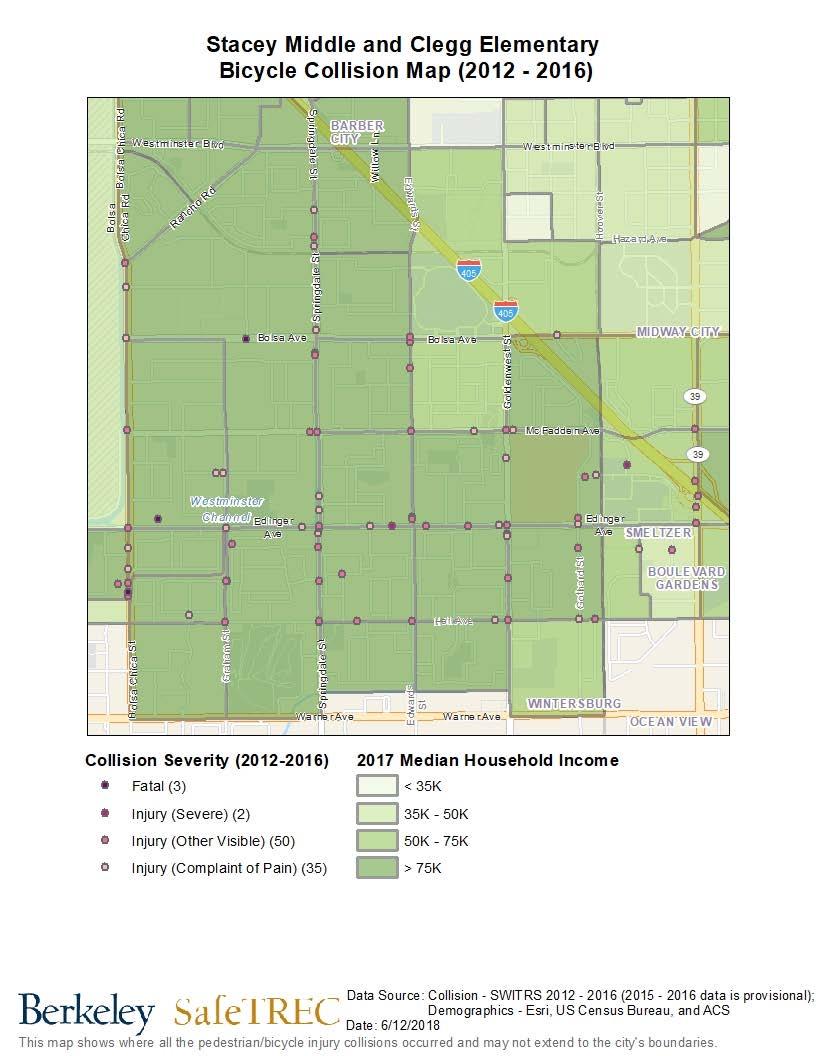
6 Existing Conditions Pedestrian & Bicycle Collision History 1 Between , there were 148 pedestrian collisions, including six (6) fatalities and twentythree (23) severe injuries, within the two-mile radius around Clegg Elementary School and Stacey Middle School. Collisions in this time period are concentrated on larger arterials: Springdale Street, Edwards Street, Goldenwest Street, Westminster Boulevard, and Beach Boulevard/California State Route 39 (CA 39). Collisions primarily occurred during high traffic times on Tuesday and Wednesday afternoons and evenings between 3:00 p.m. to 8:59 p.m. The top two collisions factors for pedestrian collisions are driver failure to yield rightof-way to pedestrians at a crosswalk (39.2%) and pedestrian failure to yield right-of-way to vehicles (20.3%). 2 Over the 5-year period between , pedestrian collisions appear to be on a downward trajectory. Between , there were 231 bicycle collisions, including three (3) fatalities and nine (9) severe injuries, within the two-mile radius around Clegg Elementary School and Stacey Middle School. Collisions in this time period are concentrated on larger arterials including: Springdale Street, Edwards Street, Goldenwest Street, Westminster Boulevard, Edinger Avenue, and Beach Boulevard/California State Route 39 (CA 39). The top two collisions factors in collisions involving bicyclists are a driver or bicyclist s failure to drive on the right half of the roadway (39.8) and unsafe turning with or without signaling by a driver or bicyclist (11.3%). 3 Over the 5-year period between , bicycle collisions appear to be on a downward trajectory SWITRS data are provisional as of March Pedestrians have the right-of-way in marked and unmarked crossings, and drivers are legally required to yield to pedestrians in these instances. However, when pedestrians cross outside of marked or unmarked crossings, pedestrians must yield the right-of-way to drivers. A pedestrian is legally able to cross outside of a marked or unmarked crossing between two intersections where one or none of the intersections is signalized but only if the pedestrian yields the right-of-way to oncoming drivers. This is not the same as the term jaywalking, which refers to crossing outside of a marked or unmarked crossing between two signalized intersections. 3 According to California Vehicle Code 21200, bicycles are considered vehicles, therefore, bicyclists on public streets have the same rights and responsibilities as automobile drivers. This makes it difficult to discern whether a bicyclist or driver is at fault. 6
7 Walking & Biking Assessment Reflections Participants were asked to 1) observe infrastructure conditions and the behavior of all road users; 2) assess the qualitative and emotional experience of walking or biking along the route; 3) identify positive community assets and strategies which can be built upon; and 4) consider how the walking and biking experience might feel different for other vulnerable users. Workshop participants conducted walking and biking assessments along three key routes: Route 1: Schools & Clegg-Stacy Park This route focused the streets immediately around Clegg Elementary School and Stacey Middle School, where parents and students walk, bike, and drive to the campuses. Starting the walking assessment at Clegg Elementary School, participants walked west along Larchwood Drive, north along Edgewood Lane, east along Glenwood Drive, and south along Sunnycrest Lane to return to Clegg Elementary School. Route 2: Westminster Mall This route focused on Edwards Street, the major arterial, and on Sunnycrest Lane, the main residential street. Both streets are used by parents and students walking, biking, and driving to and from Clegg Elementary School and Stacey Middle School. Students also use these streets to walk to Westminster Mall after school. Starting the walking assessment at Clegg Elementary School, participants walked east on Larchwood Drive, south on Sunnycrest Lane, east on Mar Vista Drive, north on Edwards Street, west on Royal Oak Drive, and south on Sunnycrest Lane to return to Clegg Elementary School. 7

8 Route 3: Larchwood Drive This route focused on Larchwood Drive and Mar Vista Drive, which are commonly used routes by parents and students traveling to and from Clegg Elementary School and Stacey Middle School. Starting the walking assessment at Clegg Elementary School, the participants walked west on Larchwood Drive to Springdale Street, east on Larchwood Drive, south on Northridge Lane, east on Mar Vista Drive, north on Sunnycrest Lane, and west on Larchwood Drive to return to Clegg Elementary School. Following the walking and biking assessment, the participants shared the following reflections: Lack of High-Visibility Crosswalks: Participants on Route 2 shared their concerns with the lack of high-visibility crosswalk markings at the intersections of Royal Oak Drive/ Sunnycrest Lane and Mar Vista Drive/Sunnycrest Lane in Huntington Beach as well as Royal Oak Drive/Edwards Street in Westminster. There is heavy foot traffic at these intersections from students, parents, and residents walking to and from school and other community destinations. Participants on Route 3 were concerned about the lack of high-visibility markings at the 3-way stops on Larchwood Drive at Edgeview Lane and Northridge Lane in Huntington Beach. High Motorist Speeds: Participants on Route 2 expressed concerns with drivers speeding without regard for the students, parents, and residents walking along Edwards Street, which borders both Huntington Beach and Westminster. Using a speed radar device, participants recorded ten motorists at random. Of this sample, nine out of ten drivers were traveling above the 40 mph speed limit at speeds ranging from 42 mph to 57 mph, which validated residents ongoing concerns with speeding on Edwards Street from the City of Westminster as they travel downhill. Unsafe Motorist Behaviors: Workshop participants noted that unsafe motorist behaviors in Huntington Beach and Westminster deter many in the school community from walking and biking in the school because they would rather drive than expose themselves to potential collisions. Participants shared that parents conduct illegal U-turns along Sunnycrest Lane, speed in the school zone, use non designated zones for arrival and dismissal periods, and beckon their children to cross the street unsafely midblock during dismissal time. Pedestrians also noted that motorists often stop midway into the crosswalk, which blocks the path of pedestrians and makes pedestrians and bicyclists uneasy as they navigate their way to school. 8


9 School Zone Signage: Participants observed a lack of school zone signage to prompt motorists to drive slower and more attentively. They called for the installation of a school zone sign on the City of Westminster segment of Edwards Boulevard in order to signal to drivers to expect students in the area. Several schools including Clegg Elementary, Stacey Middle, Westminster High, and Schroeder Elementary School are all located off of Edwards Boulevard, which is the primary route students use to walk and bike to school and parents use to drive. Loose Dogs: Participants on Route 1 were concerned about the presence of loose dogs in the Huntington Beach neighborhood. Participants shared that residents often walk their dogs without leashes and dogs regularly escape from resident yards. Participants also shared that many residents do not clean up after their pets and dog waste can be found in landscape buffers along sidewalks and in Clegg Stacey Park. Difficult Crossings at Marked and Unmarked Pedestrian Crossings: Participants on Route 1 were particularly concerned about pedestrian safety crossing in the standard marked crosswalk at the Northridge Lane/Larchwood Drive intersection. They shared that parents often make U-turns in the intersection during arrival and dismissal times and fail to yield to pedestrians in the crosswalk. Participants supported additional pedestrian crossing enhancements throughout Huntington Beach at intersections leading up to both schools, including Sunnycrest Lane/Larchwood Drive, Larchwood Drive/Edgeview Lane, Sunnycrest Lane/Royal Oak Drive, and Larchwood Drive/Northridge Lane. Supported crossing enhancements include advanced stop bars, high-visibility crosswalk markings, and pedestrian crossing signage to improve safety for students and parents walking and biking to and from school. Additionally, participants noted that signalized intersections on Edwards Street, where the cities of Huntington Beach and Westminster share a border, are particularly challenging to cross. For example, at Royal Oak Drive, the signal does not have a dedicated left turn phase onto Royal Oak Drive. The result is drivers frequently failing to yield the right-ofway to pedestrians crossing in an effort to make their left turns. Participants also noted that the twenty seconds allocated to cross at Royal Oak Drive is inadequate as they spend approximately five seconds waiting to make sure that drivers are fully stopped before they begin to cross Edwards Street. A friendly neighborhood reminder to clean up after your pet. A standard marked crosswalk along Larchwood Drive and North Ridge Lane. 9


10 Sidewalk Conditions: Sidewalk conditions vary along the three assessment routes with differing widths and levels of maintenance. Participants along Route 2 shared that sidewalks are too narrow for families walking. Participants shared that they have seen parents with strollers struggle to navigate Edwards Street in Huntington Beach. The existing sidewalks and adjacent wall do not allow for groups of three or more to walk together, which leads to some students choosing to walk in the street where drivers frequently travel above the 40 mph speed limit. While conducting the assessment, participants walking along Edwards Street in Huntington Beach were forced to walk in the street as the sidewalk was not wide enough to allow for a resident walking two dogs to pass. Following this incident, a participant shared that she would rather walk on the opposite side of Edwards Street in Westminster. Despite there being no sidewalk, without a wall on that sidem there is enough space to maneuver around Participants Participants walking walking north north on on Edwards Edwards Street Street are are forced into street due to the narrow sidewalk other people walking and avoid having to forced into street due to the narrow sidewalk walk in the street. Lack of Bike Facilities: Participants noted that despite existing bike lanes on Edwards Street in Huntington Beach and Westminster and Springdale Street in Huntington Beach, bicyclists ride on the sidewalk because the bike lanes are narrow and next to very fast moving traffic. Participants noted that bike lanes are too narrow for adults to ride comfortably let alone for parents to feel comfortable allowing their children to ride unsupervised. Bicyclist heading west on Royal Oak Drive. Participants shared that the sidewalk is the preferred location to bike for most residents. South on Edwards Street, the bike lanes are mostly in the gutter and are too narrow and too close to high speed drivers for a pleasant riding experience. 10

11 Community Assets and Culture: Participants shared that they appreciate the ample parking space, well-maintained trees and landscaped buffers, clean and level sidewalks, and friendly neighbors that characterize the neighborhood. While on the walking and biking assessment, participants observed community members walking their dogs, running, and biking in the community, which contributed to the vibrant nature of the neighborhood. Key Opportunities to Improve Walking and Biking Safety Following the walking and biking assessment, the Project Team facilitated small-group action planning discussions where participants prioritized and preliminarily planned community programs aimed at reducing the number of injuries and fatalities, as well as increasing the number of people and the frequency of walking and biking in the Clegg and Stacey school communities. Through a voting process during the training, participants chose to focus on and preliminarily plan for two community programs. Participants self-selected which project they wanted to collaborate on with their fellow participants to develop a plan and discussed: The problem the community programs are intended to solve; The people, organizations, and agencies that should be involved to implement the community programs; Resources needed to implement the community programs; and Short-term and long-term action steps to implement the community programs. Community Recommendations Workshop participants provided the following recommendations and next steps for overall pedestrian and bicyclist safety improvements: Community Programs, Policies, and Campaigns Crossing Guard Program: Participants identified a need to restart conversations with the Clegg Elementary School Principal and engage the Stacey Middle School Principal, teachers, and parents in order to build stronger support to fund the crossing guard program, which would benefit students from both schools. Earlier this year, the Clegg Elementary School Principal, parents, and PTA drafted a letter petitioning the City of Huntington Beach to fund a crossing guard at the Royal Oak Drive/Edwards Street intersection, but the process was put on hold as the school year came to an end. Participants identified the PTA president as a key contact to engage in this ongoing process. Participant crossing along Royal Oak Drive onto Edwards Street. Participants identified this intersection as a high priority for a crossing guard due to high motorist speeds. 11
12 Some longer term actions include: o Making a public comment at the upcoming school district meetings about the need for a crossing guard program and inquiring how Westminster High School and other area schools fund their crossing guard programs. o o Conducting pedestrian counts at the Royal Oak Drive/Edwards Street intersection. Gather signatures from parents at Clegg Elementary School and Stacey Middle School to demonstrate community-wide support. If the City of Huntington Beach is unable to fund the program, participants considered asking the City of Westminster, the Westminster School District, and the Westminster and Huntington Beach Police Departments to fund the needed program since many students live in Westminster. Safe Route to School Education and Encouragement Program: Participants are concerned with unsafe walking and biking behaviors by parent and students at and surrounding the schools. Participants often observe parents and students alike engaged in unsafe behaviors that can lead to harmful and fatal injuries if a collision were to occur. Rather than a punitive approach, participants outlined a Safe Routes to School program that would target the most unsafe and high-risk pedestrian and bicycle behaviors. The participants of this group which included residents, parents, a PTA member, and school staff identified educational pamphlets, distribution, and educational lawn signs with safe walking and biking tips as the most appropriate strategy for short-term implementation. Participants decided that using existing educational materials and lawn signs would aid in the rapid dissemination of safety messages to students and parents. Between October 28-30, 2018 leading up to Halloween, participants committed to: o ing an educational pamphlet to families through the schools system; o Making phone calls to parents with safe walking and biking tips; o Posting educational information on the the schools social media accounts; o o Placing educational lawn signs at key intersections leading up to the schools; and Organizing a traffic safety rally on October 30th, 2018, where, older students from Clegg Elementary would hold safety messages directed at drivers during school arrival in preparation for that evening s Halloween Trunk or Treat event. Building off of these safety messaging activities, participants planned to host a Day of Visibility around Daylight Savings Time in November 2018 to share safety messages around distracted driving and safe walking and crossing behaviors. Following these two educational campaigns, participants would like to explore hosting a Walk to School Day event that would encourage students and parents to walk and bike to school rather than arrive by car. Participants identified the Westminster Mall and Buckingham Park as potential meeting points for parents and students to start their walk or bike to school together. 12
13 Cal Walks/SafeTREC Recommendations California Walks and SafeTREC also submit the following recommendations for consideration by the City of Huntington Beach, City of Westminster, and Clegg Elementary School and Stacey Middle School community: Traffic Calming Measures along Edwards Boulevard from Bolsa Avenue to Westminster Boulevard: During the site visit and workshop, participants consistently identified Edwards Boulevard as a challenging street for residents to cross and travel on while on foot or bike. We recommend the Cities of Westminster and Huntington Beach collaborate to engage residents to identify long-term traffic calming measures, such as implementing a road diet, installing bulb-outs, enhanced crossings, and wider, physically-separated bike lanes. Participants also shared concerns about the speed of drivers on this corridor, especially those coming down the I-405 freeway ramps towards Bolsa Avenue where students and community members walk and bike to access Westminster Mall. Traffic calming improvements can decrease driver speeds and improve safety for pedestrians, bicyclists, and drivers. We recommend the Cities of Westminster and Huntington Beach engage the community in order to prepare a future application to the state s Active Transportation Program to fund these improvements. Lighting Assessment: The Project Team noted a lack of pedestrian-scale lighting in the areas along Edwards Street, Sunnycrest Lane, and Larchwood Drive in Huntington Beach and Westminster. The majority of lighting is vehicle-oriented street lighting which limits visibility for students, parents, and residents that access the neighborhood by walking or biking. The Project Team encourages and recommends the workshop participants collaborate with the City of Huntington Beach, City of Westminster, and residents to perform citywide street night-time lighting assessments focused on pedestrian and bicycle lighting needs around Clegg Elementary School, Stacey Middle School, Clegg-Stacy Park, Westminster Mall, and along key pedestrian and bicycle corridors, such as Edwards Street, Springdale Street, Larchwood Drive, Sunnycrest Lane, and Royal Oak Drive. A lighting assessment can be used to identify and inventory nighttime pedestrian-scale lighting needs and identify lighting fixtures in need of repair or replacement, and with an inventory, the City can develop a proactive and equitable plan for streetlight maintenance that is not complaint-driven. Proper street lights provide a sense of safety and security and improve the overall well-being of road users. Lighting should be uniform, consistent, and reduce glare and light pollution. Alternative Remote Arrival and Dismissal Zones: The Project Team recommends that the Planning Committee collaborate with the Westminster School District and Westminster Mall to create an alternative remote arrival and dismissal zones in the Westminster Mall or at other lots near the school. Having an off-site arrival and dismissal zone would allow parents who drive their children to school to participate in the growing walking and biking safety efforts being established at the Clegg Elementary School and Stacey Middle School campuses, as well as alleviate the traffic congestion on Sunnycrest Lane and Larchwood Drive where the current arrival and dismissal zones for Clegg Elementary School and Stacey Middle School are located, respectively. We recommend the workshop participants and parents consult the Safe Routes to 13
14 School Guide: Student Drop-off and Pick-up Guide and the Safe Routes to School Toolkit to learn about best practices to help guide their efforts. 45 Youth Bicycle Education and Encouragement: The Project Team recommends that the Planning Committee collaborate with the Westminster School District, the Westminster and Huntington Beach Police Departments, and the California Highway Patrol to bring annual bicycle rodeos to the Clegg Elementary School and Stacey Middle School campuses. A bicycle rodeo educates youth on safe bicycling practices and rules of the road through obstacle courses in a controlled environment. Simultaneously, a bicycle rodeo may serve as encouragement for youth to bicycle to and from the Clegg Elementary School and Stacey Middle School campus and in their community. Apply for a Kid s Plate Grant to Support Encouragement Activities: The California Department of Public Health s Kid s Plate Grant program funds injury prevention efforts to reduce or eliminate unintentional injuries in children and youth, 0 to 18 years of age. The grant includes bicycle safety as a key focus area. The Project Team recommends the Westminster School District PTA and Huntington Union School PTA explore potential partnerships with their respective School Districts to support pedestrian and bicycle injury prevention activities at Westminster and Huntington Beach elementary and middle schools, especially around Walk to School Day and Bike to School Day. The funding opportunity could provide additional long-term and site-specific Safe Routes to School education and encouragement programs for Westminster and Huntington Beach Schools. Establish a Task Force between the City, School District, and Police Departments of Westminster and Huntington Beach: The Project Team recommends that the City, Westminster School District, and the Police Departments of Westminster and Huntington Beach collaborate to establish a task force on walking and biking safety efforts to ensure that infrastructure improvements made near Clegg Elementary School and Stacey Middle School are coupled with improvements on adjacent routes that may be in another city. Focusing on complete infrastructure improvements regardless of jurisdictional boundaries through increased coordination will ensure that the facilities are fully usable for all road users. 4 Safe Routes to School Guide: Student Drop-off and Pick-up Guide developed by the Pedestrian and Bicycle Information Center (PBIC) with support from the National Highway Traffic Safety Administration (NHTSA), Federal Highway Administration (FHWA), Centers for Disease Control and Prevention (CDC) and Institute of Transportation Engineers (ITE). 5 Safe Routes to School Toolkit produced by the Active Transportation Alliance. 14
15 Appendix A Pedestrian and Bicycle Collision Data Analysis Workshop Handout 15
 is to make communities safer and more pleasant for walking and bicycling.")

16 STACEY MIDDLE AND CLEGG ELEMENTARY DATA ANALYSES Community Pedestrian and Bicycle Safety Training Workshop Huntington Beach, CA September 27, 2018 The goal of the Community Pedestrian and Bicycle Safety Training (CPBST) is to make communities safer and more pleasant for walking and bicycling. This workshop will train local residents and safety advocates in pedestrian and bicycle safety as well as create opportunities for collaboration with local officials and agency staff. This fact sheet highlights pedestrian and bicycle collision data to help the community better prioritize recommendations that emerge from this workshop. The data presented here is based on collisions within a twomile radius from Clegg Elementary School and Stacey Middle School in the communities of Huntington Beach and Westminster, but not data for the City of Huntington Beach or City of Westminster as a whole. 319 people were killed or injured in 290 pedestrian collisions in the last 10 years ( ). The three-year moving average line shows a downward trend in pedestrian collisions.* There were 25 pedestrian collisions in 2015, but an average of pedestrian collisions per year for the 3-year moving average between 2014 and PEDESTRIANS *This line is useful for tracking change over time, especially when the number of collisions changes a lot between years. Data points are at the midpoint of the three years of data specified. 59.5% driver violations VS. 26.4% pedestrian violations *Unclear violations were committed either by the driver, pedestrian or bicyclist. Unknown is when we do not know what the violation was. 57.4% of victims were male 27.1% of victims were under age % of victims were age % of victims (or 29 people) were KILLED or SEVERELY INJURED Data Source: California Statewide Integrated Traffic Records System (SWITRS). Collision data for 2016 is provisional at this time. Funding for this program was provided by a grant from the California Office of Traffic Safety through the National Highway Traffic Safety Administration.


17 485 people were injured in 475 bicycle collisions in the last 10 years ( ). BICYCLES The three-year moving average line shows a downward trend in bicycle collisions.* There were 37 bicycle collisions in 2015, but an average of 40 bicycle colliions per year for the 3-year rolling average between 2015 and * This line is useful for tracking change over time, especially when the number of collisions changes a lot between years. Data points are at the midpoint of the three years of data specified. Bicycles must follow all the same rules of the road as vehicles. As a result, we cannot break down violations by driver vs. bicyclist. 75.7% of victims were male 33.5% of victims were under age % of victims were male and under age % of victims (or 12 people) were KILLED or SEVERELY INJURED 34.6 pedestrian fatalities & injuries per 100,000 population in Huntington Beach over the last five years, which is 23.1% more than Orange County and 3.6% less than California 38.0 pedestrian fatalities & injuries per 100,000 population in Westminster over the last five years, which is 35.2% more than Orange County and 5.8% more than California 70.2 bicyclist fatalities & injuries per 100,000 population in Huntington Beach over the last five years, which is 84.3% more than Orange County and 110.8% more than California 51.1 bicyclist fatalities & injuries per 100,000 population in Westminster over the last five years, which is 34.1% more than Orange County and 53.4% more than California SUMMARY Yearly Population Rate of Fatalities & Injuries per 100,000 Population Calculated Over a 5-year Period* Pedestrian Bicyclist Huntington Beach Westminster Orange County California Source: U.S. Census Bureau, Population Division (intercensal population data for 2016). * The rate per population is calculated b adding the number of fatalities and injuries from 2012 to 2016 divided by five times the population in 2016.
.")
18 Pedestrian Collisions two-mile radius from Clegg Elementary School & Stacey Middle School in Huntington Beach, CA and Westminster, CA Data Source: California Statewide Integrated Traffic Records System (SWITRS). Collision data for 2016 is provisional.
.")
19 Bicyclist collision locations, two-mile radius from Clegg Elementary School & Stacey Middle School in Huntington Beach, CA and Westminster, CA Data Source: California Statewide Integrated Traffic Records System (SWITRS). Collision data for 2016 is provisional.
20 Appendix B Pedestrian and Bicycle Collision Data Analysis Site Visit Presentation 20
 data are provisional as of November 2017.")
21 Community Pedestrian and Bicycle Safety Workshop - Data Huntington Beach, CA 6/29/18 Pedestrian Injury Collision Trend with 3-year moving average Note: 2015 and 2016 Statewide integrated Traffic Records Systems (SWITRS) data are provisional as of November 2017.

22 Pedestrian Injury Collisions Note: 2015 and 2016 SWITRS data are provisional as of November 2017.
23

24 Pedestrian Injury Collisions by Time of Day and Day of Week Total: 44 collisions *One unknown time on Sunday *The color in this graph refer to how frequently a collision occurs at that time and day Top Violations in Pedestrian Injury Collisions Total: 44 collisions

25 Pedestrian Victim Injury Severity Source: SWITRS, ; 2015 and 2016 SWITRS are provisional as of November 2017.

26 Pedestrian Injury Victims by Age and Gender Note: 2015 and 2016 SWITRS data are provisional as of November 2017.

27 Bicycle Injury Collision Trend with 3-year moving average Note: 2015 and 2016 SWITRS data are provisional as of November 2017.


28 Bicycle Injury Collisions Note: 2015 and 2016 SWITRS data are provisional as of November 2017.
29

30 Bicycle Injury Collisions by Time of Day and Day of Week Total: 90 collisions *The color in this graph refer to how frequently a collision occurs at that time and day Top Violations in Bicycle Injury Collisions
31 Bicycle Victim Injury Severity Note: 2015 and 2016 SWITRS data are provisional as of November 2017.

32 Bicycle Injury Victims by Age and Gender Note: 2015 and 2016 SWITRS data are provisional as of November 2017.


33 Ada Clegg Elementary 6311 Larchwood Drive Huntington Beach Orange County CDS: Helen Stacey Middle 6311 Larchwood Drive Huntington Beach Orange County CDS:
. To further explore collision data, register for a free account to access the tools and resources on TIMS. https://tims.berkeley.")
34 The Transportation Injury Mapping System (TIMS) is a web-based tool that allows users to analyze and map data from California's Statewide Integrated Traffic Records System (SWITRS). To further explore collision data, register for a free account to access the tools and resources on TIMS. Berkeley SafeTREC
Recommendations to Improve Pedestrian & Bicycle Safety for the Arden-Arcade Community
 Recommendations to Improve Pedestrian & Bicycle Safety for the Arden-Arcade Community June 2018 Acknowledgements Planning Committee Joelle Orrock Gail Kelly Molly Patterson Dan Allison Heather Yee Molly
Recommendations to Improve Pedestrian & Bicycle Safety for the City of Arvin
 Recommendations to Improve Pedestrian & Bicycle Safety for the City of Arvin July 2018 1 Acknowledgements Planning Committee Jack Becker Tammy Fisher Pat Ebel Peter Smith Carlos Bello Christine Viterelli
Recommendations to Improve Pedestrian & Bicycle Safety for the City of Hayward: Tennyson Road Corridor
 Recommendations to Improve Pedestrian & Bicycle Safety for the City of Hayward: Tennyson Road Corridor October 2018 1 Acknowledgments Planning Committee Charmine Solla Steven Chang Patty Garcia Sergio
Recommendations to Improve Pedestrian & Bicycle Safety in the Azusa Unified School District
 Recommendations to Improve Pedestrian & Bicycle Safety in the Azusa Unified School District October 2017 Recommendations to Improve Pedestrian & Bicycle Safety in the Azusa Unified School District By Mihaela
RECOMMENDATIONS TO IMPROVE PEDESTRIAN & BICYCLE SAFETY IN THE COMMUNITY OF FLORENCE-FIRESTONE
 RECOMMENDATIONS TO IMPROVE PEDESTRIAN & BICYCLE SAFETY IN THE COMMUNITY OF FLORENCE-FIRESTONE September 2017 By Miha Tomuta, Wendy Ortiz, California Walks; Jill Cooper, Katherine Chen, UC Berkeley SafeTREC
Recommendations to Improve Pedestrian & Bicycle Safety for the Zane Middle School Community
 Recommendations to Improve Pedestrian & Bicycle Safety for the Zane Middle School Community October 2018 1 Acknowledgements Planning Committee Nicole Sager Jesse Willor Jenny Weiss Emily Sinkhorn Scott
Recommendations to Improve Pedestrian & Bicycle Safety for the Missouri Flat Area (El Dorado County)
") Recommendations to Improve Pedestrian & Bicycle Safety for the Missouri Flat Area (El Dorado County) October 2017 Recommendations to Improve Pedestrian & Bicycle Safety for the Missouri Flat Area (El Dorado
Recommendations to Improve Pedestrian & Bicycle Safety for the Missouri Flat Area (El Dorado County) October 2017 Recommendations to Improve Pedestrian & Bicycle Safety for the Missouri Flat Area (El Dorado
Recommendations to Improve Pedestrian & Bicycle Safety for the City of Lemon Grove
 Recommendations to Improve Pedestrian & Bicycle Safety for the City of Lemon Grove October 2018 1 Acknowledgements Planning Committee Anita Lopez Rosa Carney Steve Browne Angeles Nelson Lemon Grove Healthy
Recommendations to Improve Pedestrian & Bicycle Safety for the Community of North Shore
 Recommendations to Improve Pedestrian & Bicycle Safety for the Community of North Shore October 2017 Recommendations to Improve Pedestrian & Bicycle Safety for the Community of North Shore By Tony Dang,
Recommendations to Improve Pedestrian & Bicycle Safety for the City of Bakersfield
 Recommendations to Improve Pedestrian & Bicycle Safety for the City of Bakersfield August 2018 1 Acknowledgements Planning Committee Jack Becker Bike Bakersfield Cindy Parra Bike Bakersfield Christopher
Recommendations to Improve Pedestrian & Bicycle Safety for the Community of Palermo
 Recommendations to Improve Pedestrian & Bicycle Safety for the Community of Palermo September 2017 Recommendations to Improve Pedestrian & Bicycle Safety for the Community of Palermo By Wendy Ortiz, Jaime
RECOMMENDATIONS TO IMPROVE PEDESTRIAN & BICYCLIST SAFETY IN LOS ANGELES CHINATOWN
 RECOMMENDATIONS TO IMPROVE PEDESTRIAN & BICYCLIST SAFETY IN LOS ANGELES CHINATOWN October 2016 By Tony Dang, Caro Jauregui, Jaime Fearer, Wendy Alfsen, California Walks; Jill Cooper, Katherine Chen, UC
Recommendations to Improve Pedestrian & Bicycle Safety for the Community of Southwest Fresno
 Recommendations to Improve Pedestrian & Bicycle Safety for the Community of Southwest Fresno October 2017 Recommendations to Improve Pedestrian & Bicycle Safety for the Community of Southwest Fresno By
RECOMMENDATIONS TO IMPROVE PEDESTRIAN & BICYCLE SAFETY IN ROSEMONT
 RECOMMENDATIONS TO IMPROVE PEDESTRIAN & BICYCLE SAFETY IN ROSEMONT SEPT 2017 By Tony Dang, Jaime Fearer, Miha Tomuta, Wendy Ortiz, California Walks; Jill Cooper, Jessica Rosas, UC Berkeley SafeTREC Recommendations
Bicycle Master Plan Goals, Strategies, and Policies
 Bicycle Master Plan Goals, Strategies, and Policies Mobilizing 5 This chapter outlines the overarching goals, action statements, and action items Long Beach will take in order to achieve its vision of
Recommendations to Improve Pedestrian & Bicycle Safety for the Valley West Community in Arcata
 Recommendations to Improve Pedestrian & Bicycle Safety for the Valley West Community in Arcata October 2018 1 Acknowledgements Planning Committee Netra Khatri Julie Neander Emily Sinkhorn Jennifer Weiss
RECOMMENDATIONS TO IMPROVE PEDESTRIAN & BICYCLIST SAFETY FOR THE MOUNTAIN VIEW SCHOOL DISTRICT (EL MONTE/SOUTH EL MONTE)
") RECOMMENDATIONS TO IMPROVE PEDESTRIAN & BICYCLIST SAFETY FOR THE MOUNTAIN VIEW SCHOOL DISTRICT (EL MONTE/SOUTH EL MONTE) August 2016 By Caro Jauregui, Jaime Fearer, Tony Dang, Wendy Alfsen California Walks;
RECOMMENDATIONS TO IMPROVE PEDESTRIAN & BICYCLIST SAFETY FOR THE MOUNTAIN VIEW SCHOOL DISTRICT (EL MONTE/SOUTH EL MONTE) August 2016 By Caro Jauregui, Jaime Fearer, Tony Dang, Wendy Alfsen California Walks;
RECOMMENDATIONS TO IMPROVE PEDESTRIAN SAFETY IN MCKINLEYVILLE
 RECOMMENDATIONS TO IMPROVE PEDESTRIAN SAFETY IN MCKINLEYVILLE May 2015 By Tony Dang, Jaime Fearer, Wendy Alfsen, California Walks; Jill Cooper, UC Berkeley SafeTREC Recommendations to Improve Pedestrian
CITY OF OAK CREEK SAFE ROUTES TO SCHOOL ACTION PLAN. East Middle School
 CITY OF OAK CREEK SAFE ROUTES TO SCHOOL ACTION PLAN East Middle School CITY OF OAK CREEK SAFE ROUTES TO SCHOOL ACTION PLAN East Middle School Why Safe Routes to School? Safe Routes to School ( SRTS ) is
SAFE ROUTES TO SCHOOL
 SAFE ROUTES TO SCHOOL Forest Ridge Elementary School Existing Conditions and ACTION PLAN > Oak Creek - Franklin Joint School District Table of Contents CONTEXT Enrollment Boundaries
City of San Diego Vision Zero Draft Strategic Plan FY 2017
 City of San Diego Vision Zero Draft Strategic Plan FY 2017 Engineering Objective: To develop and implement a strategy that employs best planning, design and engineering practices. Background: Over the
SAFE ROUTES TO SCHOOL (SR2S)
") SAFE ROUTES TO SCHOOL (SR2S) In partnership with Burbank Unified School District (BUSD) & City of Burbank George Washington Elementary School Thomas Jefferson Elementary School John Muir Middle School
SAFE ROUTES TO SCHOOL (SR2S) In partnership with Burbank Unified School District (BUSD) & City of Burbank George Washington Elementary School Thomas Jefferson Elementary School John Muir Middle School
PEDESTRIAN ACTION PLAN
 ATTACHMENT 2 CITY OF SANTA MONICA PEDESTRIAN ACTION PLAN CITY OF SANTA MONICA PEDESTRIAN ACTION PLAN This page intentionally left blank EXECUTIVE SUMMARY CHAPTER 1 EXECUTIVE SUMMARY Setting the Stage
City of Novi Non-Motorized Master Plan 2011 Executive Summary
 City of Novi Non-Motorized Master Plan 2011 Executive Summary Prepared by: February 28, 2011 Why Plan? Encouraging healthy, active lifestyles through pathway and sidewalk connectivity has been a focus
FHWA Resources for Pedestrian and Bicycle Professionals
 FHWA Resources for Pedestrian and Bicycle Professionals Charlie Zegeer, UNC Highway Safety Research Center/PBIC Libby Thomas, UNC Highway Safety Research Center Dan Nabors, Vanasse Hangen Brustlin (VHB)
POLICY AGENDA For Elder Pedestrian Safety
 POLICY AGENDA For Elder Pedestrian Safety Older adults and people with disabilities often have mobility, cognitive, and sensory limitations that affect their behavior as pedestrians and place them at risk
8. Collisions INTRODUCTION
 8. Collisions INTRODUCTION While traffic collisions can affect anyone, they have a disproportionate impact on bicyclists, who along with pedestrians are the most vulnerable users of the transportation
Safe Routes to School Guide
 Safe Routes to School Guide Steps to Creating a Safe Routes to School Program Created February 2007 SafeRoutes National Center for Safe Routes to School This guide was developed by the Pedestrian and Bicycle
Agenda. Overview PRINCE GEORGE S PLAZA METRO AREA PEDESTRIAN PLAN
 PRINCE GEORGE S PLAZA METRO AREA PEDESTRIAN PLAN May 28, 2008 Agenda Welcome and introductions Project overview and issue identification Planning context and strengths Design challenges and initial recommendations
Pedestrian Safety Action Plan Bicycle Safety Action Plan
 Pedestrian Safety Action Plan Bicycle Safety Action Plan January 24, 2017 VISION: Safe travel for all MISSION STATEMENT: Partner with the community to plan and fund transportation projects and programs
Bringing together community and health. Physical Activity and Nutrition Unit Office of Statewide Health Improvement Initiatives
 Bringing together community and health. Physical Activity and Nutrition Unit Office of Statewide Health Improvement Initiatives Physical Activity and Nutrition Unit Office of Statewide Health Improvement
COMMUNITY PEDESTRAIN SAFETY TRAINING. Long Beach June 5 th, 2010
 COMMUNITY PEDESTRAIN SAFETY TRAINING Long Beach June 5 th, 2010 Long Beach The City of Long Beach is located in Los Angeles County, Southern California. Long Beach is currently home to 462,604 persons
5. Pedestrian System. Accomplishments Over the Past Five Years
 5. Pedestrian System Accomplishments Over the Past Five Years The Alamo Area Metropolitan Planning Organization (MPO) and its partner agencies recognize the importance of improving pedestrian mobility.
Northbound San Jose Avenue & I-280 Off-Ramp Road Diet Pilot Project
 Project Overview Fed by a two-lane Interstate-280 (I-280) off-ramp, high vehicular volumes and speeds are longstanding issues along San Jose Avenue. Residents in the surrounding neighborhoods have expressed
SAFE ROUTES TO SCHOOL
 SAFE ROUTES TO SCHOOL Edgewood Elementary School Existing Conditions and ACTION PLAN > Oak Creek - Franklin Joint School District Table of Contents CONTEXT Enrollment Boundaries Enrollment
Chapter 2. Bellingham Bicycle Master Plan Chapter 2: Policies and Actions
 Chapter 2 Bellingham Bicycle Master Plan Chapter 2: Policies and Actions Chapter 2: Policies and Actions The Bicycle Master Plan provides a road map for making bicycling in Bellingham a viable transportation
Living Streets Policy
 Living Streets Policy Introduction Living streets balance the needs of motorists, bicyclists, pedestrians and transit riders in ways that promote safety and convenience, enhance community identity, create
PRINCE GEORGE S PLAZA METRO AREA PEDESTRIAN PLAN
 PRINCE GEORGE S PLAZA METRO AREA PEDESTRIAN PLAN May 28, 2008 Agenda Welcome and introductions Project overview and issue identification Planning context and strengths Design challenges and initial recommendations
CONNECTING PEOPLE TO PLACES
 CONNECTING PEOPLE TO PLACES 82 EAST BENCH MASTER PLAN 07 Introduction The East Bench transportation system is a collection of slow moving, treelined residential streets and major arteries that are the
Traffic Safety Plan Traffic Safety Plan 2015
 Traffic Safety Plan 2015 Purpose Airdrie s last Traffic Safety Plan was created in 2011. The 2015 Traffic Safety Plan is a revised model of the traffic operations for the City of Airdrie. The purpose of
Active Transportation Facility Glossary
 Active Transportation Facility Glossary This document defines different active transportation facilities and suggests appropriate corridor types. Click on a facility type to jump to its definition. Bike
TRAFFIC CALMING TOOLBOX. For the residents of the City of Decatur, Georgia
 TRAFFIC CALMING TOOLBOX For the residents of the City of Decatur, Georgia 2 City of Decatur Traffic Calming Toolbox Public Works Department 2635 Talley Street Decatur, GA 30030 404.377.5571 3 Welcome to
COMMUNITY PEDESTRAIN SAFETY TRAINING. Santa Ana June 27 th 2009
 COMMUNITY PEDESTRAIN SAFETY TRAINING Santa Ana June 27 th 2009 Santa Ana Santa Ana is the heart of Orange County located in Southern California. The estimated population of Santa Ana is 339,130 in 2008,
Pedestrian injuries in San Francisco: distribution, causes, and solutions
 Pedestrian injuries in San Francisco: distribution, causes, and solutions Presentation to the San Francisco Health Commission RAJIV BHATIA, MD, MPH DIRECTOR OF OCCUPATIONAL AND ENVIRONMENTAL HEALTH, SAN
Chapter 14 PARLIER RELATIONSHIP TO CITY PLANS AND POLICIES. Recommendations to Improve Pedestrian Safety in the City of Parlier (2014)
") Chapter 14 PARLIER This chapter describes the current status and future plans for biking and walking in the City of Parlier. RELATIONSHIP TO CITY PLANS AND POLICIES The Parlier General Plan is the primary
Chapter 14 PARLIER This chapter describes the current status and future plans for biking and walking in the City of Parlier. RELATIONSHIP TO CITY PLANS AND POLICIES The Parlier General Plan is the primary
REGIONAL BICYCLE AND PEDESTRIAN DESIGN GUIDELINES
 REGIONAL BICYCLE AND PEDESTRIAN DESIGN GUIDELINES November 16, 2011 Deb Humphreys North Central Texas Council of Governments Bicycle and Pedestrian Advisory Committee Snapshot of the Guide 1. Introduction
NEIGHBORHOOD TRAFFIC CALMING POLICY
 NEIGHBORHOOD TRAFFIC CALMING POLICY I. PURPOSE The City of Kent continually strives to strengthen and protect its neighborhoods by improving the quality of life in residential areas. Traffic conditions
FINAL PLAN APPENDIX D CITY OF BERKELEY BIKE PLAN D-1
 CITY OF BERKELEY BIKE PLAN D-1 . Proposed Programs D.1. EDUCATION This appendix presents the recommended bicycle-related programs for the City of Berkeley. The recommendations are organized in four E s:
Why Zone In on Speed Reduction?
 Learn it. Do it. Live it! SPEED REDUCTION IN THE ZONE Why Zone In on Speed Reduction? Speeding is a serious issue that plays a major role in the risk of serious injury and pedestrian fatality in a crash.
Residential Traffic Calming Program Guide. Town of Ashland, Virginia
 Residential Traffic Calming Program Guide Town of Ashland, Virginia August 1, 2006 TABLE OF CONTENTS A. INTRODUCTION... 1 B. GOALS... 1 C. CRITERIA... 1 D. IDENTIFYING NEIGHBORHOOD TRAFFIC CONCERNS...
RECOMMENDATIONS TO IMPROVE PEDESTRIAN SAFETY IN THE TOWN OF PARADISE
 RECOMMENDATIONS TO IMPROVE PEDESTRIAN SAFETY IN THE TOWN OF PARADISE September 2013 By Tony Dang, Wendy Alfsen, California WALKS This report is funded by the UC Berkeley Safe Transportation Research and
Focus on Enforcement. 7/21/2017 Presentation to SFMTA Policy & Governance Committee. Joe Lapka Corina Monzón
 Focus on Enforcement Insights from research and analysis in support of San Francisco s Vision Zero plan to eliminate traffic deaths Joe Lapka Corina Monzón 7/21/2017 Presentation to SFMTA Policy & Governance
Toward Zero Deaths. Regional SHSP Road Show Meeting. Virginia Strategic Highway Safety Plan. presented by
 Toward Zero Deaths Regional SHSP Road Show Meeting presented by Virginia Strategic Highway Safety Plan December 1, 2016 1 Welcome & Introductions Purpose of the Meeting Objectives & Key Outcomes Agenda»
CHAPTER 3: Vision Statement and Goals
 Davidson Walks & Rolls: Active Transportation Master Plan CHAPTER 3 Contents: Overview Vision Statement Measurable Goals Public Outreach CHAPTER 3: Vision Statement and Goals Overview The vision statement
Bikeway action plan. Bicycle Friendly Community Workshop March 5, 2007 Rochester, MN
 Bikeway action plan Summary The was held on March 5, 2007 at the Rochester Mayo Civic Center. The workshop was hosted by Rochester-Olmsted County Planning Department in collaboration with the League of
AMENDING MOTION: Mobility Plan - Pedestrians and Disadvantaged Communities
 I MOVE that the Council: AMENDING MOTION: Mobility Plan - Pedestrians and Disadvantaged Communities 1. INSTRUCT the Department of City Planning to amend the proposed Mobility Plan to include the following;
San Rafael School District. Task Force Meeting Notes. November 5, 2012
 San Rafael School District Task Force Meeting Notes November 5, 2012 Attendees (8) Wendi Kallins Program Director for Safe Routes to Schools; Laura Kelly Volunteer Liaison for Safe Routes to Schools; Leslie
RESOLUTION NO ?? A RESOLUTION OF THE CITY OF NEPTUNE BEACH ADOPTING A COMPLETE STREETS POLICY
 RESOLUTION NO. 2018-?? A RESOLUTION OF THE CITY OF NEPTUNE BEACH ADOPTING A COMPLETE STREETS POLICY WHEREAS, safe, convenient, and accessible transportation for all users is a priority of the City of Neptune
TABLE OF CONTENTS. Executive Summary
 Executive Summary Background... ES-1 Pedestrian Network... ES-2 Bikeway Network... ES-2 Collision History... ES-2 Public Input... ES-4 Conclusions and Recommendations... ES-4 1. Introduction and Setting
NYC Pedestrian Safety Study & Action Plan. NYTMC Brown Bag Lunch Presentation December 15, 2010
 NYC Pedestrian Safety Study & Action Plan NYTMC Brown Bag Lunch Presentation December 15, 2010 1 Introduction DOT Safety Goal Strategic Plan: Reduce Fatalities by 50% by 2030 From 274 (2007) to 137 (2030)
SLOW DOWN A STUDY OF SPEEDING ON MCGUINNESS BLVD
 SLOW DOWN A STUDY OF SPEEDING ON MCGUINNESS BLVD ACKNOWLEDGEMENTS This report was prepared by Shawn Macias, in consultation with the McGuinness Boulevard Working Group. This report would not have been
Welcome! San Jose Avenue Open House August 25, 2015
 Welcome! San Jose Avenue Open House August 25, 2015 Vision Zero The City and County of San Francisco adopted Vision Zero San Francisco Vision Zero High Injury Network as a policy in 2014, committing an
Broad Street Bicycle Boulevard Design Guidelines
 Broad Street Bicycle Boulevard Design Guidelines Building from the strategies introduced in the 2013 Bicycle Transportation Plan and community input received thus far, City Transportation Staff have identified
» Draft Recommendations» Discussion» Next Steps. Plan for Walking and Biking
 SAC Meeting Plan #3 for September Walking and 12, Biking 2018 » Draft Recommendations» Discussion» Next Steps Plan for Walking and Biking » Stakeholder and Public Outreach» Background data collection and
Corpus Christi Metropolitan Transportation Plan Fiscal Year Introduction:
 Introduction: The Safe, Accountable, Flexible, Efficient Transportation Equity Act: A Legacy for Users (SAFETEA-LU) has continued the efforts started through the Intermodal Surface Transportation Efficiency
Safe Routes to School Grant Application Phase I March 2014
 Safe Routes to School Grant Application Phase I March 2014 Page 1 The City of Mission is requesting grant funding to create a Safe Routes to School Plan which will encompass all of the existing elementary
11/3/2014 VIA . WALKSacramento has reviewed the Stockton and T Mixed-Use project at 3675 T Street in the
 11/3/2014 VIA EMAIL Antonio Ablog Planning Department City of Sacramento 300 Richards Boulevard Sacramento, CA 95811 RE: Design Review for Stockton and T Mixed-Use (P14-042) Dear Mr. Ablog: WALKSacramento
Crosswalk event overview (Saint Paul) How to organize a crosswalk event. 1. Choose a date, time and location
 How to organize a crosswalk event. 1. Choose a date, time and location") Crosswalk event overview (Saint Paul) A crosswalk event occurs when an individual or group of individuals promote pedestrian safety by demonstrating the proper use of a crosswalk. During the event, a group
Crosswalk event overview (Saint Paul) A crosswalk event occurs when an individual or group of individuals promote pedestrian safety by demonstrating the proper use of a crosswalk. During the event, a group
Oakland Pedestrian Master Plan Oakland Pedestrian Plan Draft Recommendations Chapter Outline
 EISEN LETUNIC T R A N S P O R T A T I O N, ENVIRO N M E N TA L A N D URBAN PLANNIN G MEMORANDUM To Oakland Pedestrian Plan Technical Advisory Committee & Pedestrian Advisory Group From Victoria Eisen Date
MEMORANDUM. City Constituents. Leilani Schwarcz, Vision Zero Surveillance Epidemiologist, SFDPH
 MEMORANDUM TO: FROM: CC: City Constituents Leilani Schwarcz, Vision Zero Surveillance Epidemiologist, SFDPH Megan Wier, Co-Chair, San Francisco Vision Zero Task Force, SFDPH Commander Ann Mannix, Traffic
Perryville TOD and Greenway Plan
 Perryville TOD and Greenway Plan Greenway Glossary Pathway: A bicycle and pedestrian path separated from motorized vehicular traffic by an open space, barrier or curb. Multi-use paths may be within the
Vulnerable Road Users Safety: What Cities Can Do To Make Things Better?
 Vulnerable Road Users Safety: What Cities Can Do To Make Things Better? Transportation Research Board Webinar September 27, 2016 Robert Hull, Cambridge Systematics, Inc. The Issue Today NHTSA 2015 estimates:
DRAFT MOVING FORWARD RHODE ISLAND BICYCLE MOBILITY PLAN 2018 PREPARED FOR PREPARED BY IN ASSOCIATION WITH
 RHODE ISLAND MOVING FORWARD BICYCLE MOBILITY PLAN 2018 PREPARED FOR PREPARED BY IN ASSOCIATION WITH T AF CHAPTER 1 D R INTRODUCTION CHAPTER 3 ARTICULATES VISION Bicycling is safe, fun and practical in
Safer Cycling: How the City of Vancouver is Proactively Improving Cycling Safety
 Safer Cycling: How the City of Vancouver is Proactively Improving Cycling Safety Brian Patterson, MCIP, RPP Urban Systems 2015 Canadian Association of Road Safety Professionals (CARSP) Conference Session
UPDATES, SUCCESSES, AND WHAT S AHEAD ON THE ROAD TO ZERO
 Vol. 1, Issue 1 I Spring 2018 www.planhillsborough.org/vision-zero S A F E S T R E E T S N O W H I L L S B O R O U G H UPDATES, SUCCESSES, AND WHAT S AHEAD ON THE ROAD TO ZERO TRACKING PROGRESS This is
LANE ELIMINATION PROJECTS
 PRESENTATION OUTLINE Lane Elimination Considerations Districts 4 & 7 Draft Lane Elimination Processes FDOT Lane Elimination Guidelines Example Projects D4 Case Study: SR A1A (Ft. Lauderdale) D7 Case Study:
Vision Zero Task Force February 28, Collision Landscape Analysis
 Vision Zero Task Force February 28, 2017 Collision Landscape Analysis Welcome! What happened since our last Task Force meeting: City Council adopted the Vision Zero Resolution Applied for an OTS grant
July 5, Arthur R. Ware, Jr. Elementary School 2017 Safe Routes to School Walkabout Report
 July 5, 2017 Arthur R. Ware, Jr. Elementary School 2017 Safe Routes to School Walkabout Report 1 Walkabout Report Introduction On April 28, 2017, City, School, and SAWMPO staff met to conduct a Safe Routes
CITY OF VISTA TRAFFIC CALMING PROGRAM
 CITY OF VISTA TRAFFIC CALMING PROGRAM The purpose of the Vista Traffic Calming Program is to reduce speeds of motorists driving through residential neighborhoods. The program does not apply to nonresidential
BETHEL ROAD AND SEDGWICK ROAD CORRIDOR STUDY
 DRAFT PLAN City Council Meeting August 14, 2017 STUDY AREA Sedgwick Corridor State Route 160, principal arterial with Class 3 access management designation, commuter and freight route, connection to SR
City of Elizabeth City Neighborhood Traffic Calming Policy and Guidelines
 City of Elizabeth City Neighborhood Traffic Calming Policy and Guidelines I. Purpose: The City of Elizabeth City is committed to ensure the overall safety and livability of residential neighborhoods. One
ITE Northeastern District Meeting
 West Hartford Road Diet and Safety Study ITE Northeastern District Meeting Session 2A Complete Streets May 22, 2018 North Main St. - Classified as a principal arterial But provides high levels of access
12/4/2016 VIA . RE: Grocery Outlet Del Paso (DR16-328)
") 12/4/2016 VIA EMAIL Ethan Meltzer, Assistant Planner City of Sacramento Community Development Department 300 Richards Blvd, 3 rd Floor Sacramento, CA 95811 RE: Grocery Outlet Del Paso (DR16-328) Dear Mr.
12/4/2016 VIA EMAIL Ethan Meltzer, Assistant Planner City of Sacramento Community Development Department 300 Richards Blvd, 3 rd Floor Sacramento, CA 95811 RE: Grocery Outlet Del Paso (DR16-328) Dear Mr.
Appendix E: Bike Crash Analysis ( )
") Appendix E: Bike Crash Analysis (2009-2012) Davis Bicycle Crashes Analysis 2009-2012 December 2013 Ride Walk Davis Active Transportation Program City of Davis December 2013 Prepared by: Jimmy Fong Active
Appendix E: Bike Crash Analysis (2009-2012) Davis Bicycle Crashes Analysis 2009-2012 December 2013 Ride Walk Davis Active Transportation Program City of Davis December 2013 Prepared by: Jimmy Fong Active
C/CAG. Sunnybrae Elementary School Walking and Bicycling Audit. San Mateo-Foster City School District JUNE 2013
 Sunnybrae Elementary School Walking and Bicycling Audit JUNE 2013 San Mateo-Foster City School District C/CAG City/County Association of Governments of San Mateo County SUNNYBRAE ELEMENTARY SCHOOL WALKING
MASTER BICYCLE AND PEDESTRIAN PLAN
 VILLAGE OF NORTHBROOK MASTER BICYCLE AND PEDESTRIAN PLAN DRAFT PLAN OPEN HOUSE May 2, 2018 AGENDA 1. Community Engagement 2. Vision and Goals 3. General Structure of Plan 4. Recommendations Overview 5.
2015 Florida Main Street Annual Conference. Complete Streets Equal Stronger Main Streets
 WHAT ARE COMPLETE STREETS? CASE STUDIES COMPLETING YOUR MAIN STREET 2015 Florida Main Street Annual Conference St. Petersburg, Florida August 19, 2015 WHAT ARE COMPLETE STREETS? CASE STUDIES COMPLETING
City of Ann Arbor Pedestrian Safety & Access Task Force
 City of Ann Arbor Pedestrian Safety & Access Task Force (PSATF) Community Wide Meeting Wednesday, July 8th 6:30 to 8:30 PM Multi purpose Room, Downtown Library www.a2gov.org/pedsafety The Greenway Collaborative,
5/7/2013 VIA . RE: University Village Safeway Expansion (P13-019)
") 5/7/2013 VIA EMAIL David Hung, Associate Planner Community Development Department, Current Planning Division City of Sacramento 300 Richards Boulevard, 3 rd Floor Sacramento, CA 95811 RE: University Village
5/7/2013 VIA EMAIL David Hung, Associate Planner Community Development Department, Current Planning Division City of Sacramento 300 Richards Boulevard, 3 rd Floor Sacramento, CA 95811 RE: University Village
8/31/2016 VIA . RE: Freeport Arco Fuel Station (P16-039)
") 8/31/2016 VIA EMAIL Garrett Norman, Assistant Planner City of Sacramento Community Development Department 300 Richards Boulevard, 3 rd Floor Sacramento, CA 95811 RE: Freeport Arco Fuel Station (P16-039)
8/31/2016 VIA EMAIL Garrett Norman, Assistant Planner City of Sacramento Community Development Department 300 Richards Boulevard, 3 rd Floor Sacramento, CA 95811 RE: Freeport Arco Fuel Station (P16-039)
CITY OF LOS ANGELES INTER-DEPARTMENTAL MEMORANDUM
 CITY OF LOS ANGELES INTER-DEPARTMENTAL MEMORANDUM Date: April 1, 219 To: Honorable City Council c/o City Clerk, Room 395, City Hall Attention: Honorable Mike Bonin, Chair, Transportation Committee From:
STATUS OF 2009 PEDESTRIAN MASTER PLAN (AS OF DECEMBER 2013)
") Appendix P.1 STATUS OF 2009 PEDESTRIAN MASTER PLAN (AS OF DECEMBER 2013) The 2009 Pedestrian Master Plan establishes 21 core recommendations in three goal areas to improve pedestrian transportation in
Appendix P.1 STATUS OF 2009 PEDESTRIAN MASTER PLAN (AS OF DECEMBER 2013) The 2009 Pedestrian Master Plan establishes 21 core recommendations in three goal areas to improve pedestrian transportation in
TRANSPORTATION TRAINING TOPICS. April 6, 2010
 TRANSPORTATION TRAINING TOPICS April 6, 2010 Roles of Transportation Providers Context and Policy Makers Division of Transportation and Traffic Other City Operations Other Transportation Operators CMA
Clay Street Bridge Replacement Project
 Clay Street Bridge Replacement Project Frequently Asked Questions (FAQs) The project is located in downtown Placerville on Clay Street between US Highway 50 and Main Street and Cedar Ravine Road. The proposed
City of Vallejo Traffic Calming Toolbox
 City of Vallejo Traffic Calming Toolbox June 1, 2013 Final Table of Contents Introduction... 1 Non-Physical Devices... 3 High-Visibility Crosswalk... 3 In Pavement Lighted Crosswalk... 4 Rapid Flashing
Lisa Quinn Executive Director
 Transforming Injury and Violence Prevention: Innovations in Policy, Practice, and Partnerships Advocating for Prevention: Enacting and Reacting to Legislation Lisa Quinn Executive Director Feet First works
6/14/2013 VIA . Evan Compton, Associate Planner Community Development Department City of Sacramento 300 Richards Blvd Sacramento, CA 95814
 6/14/2013 VIA EMAIL Evan Compton, Associate Planner Community Development Department City of Sacramento 300 Richards Blvd RE: Sacramento Natural Foods Co-Op (P13-025) Dear Mr. Compton: WALKSacramento appreciates
o n - m o t o r i z e d transportation is an overlooked element that can greatly enhance the overall quality of life for the community s residents.
 N o n - m o t o r i z e d transportation is an overlooked element that can greatly enhance the overall quality of life for the community s residents. 84 Transportation CHAPTER 11 INTRODUCTION Transportation
FEDERAL HIGHWAY ADMINISTRATION APPLICATION
 FEDERAL HIGHWAY ADMINISTRATION APPLICATION REQUEST FOR PERMISSION TO EXPERIMENT WITH A BICYCLE BOX INTERSECTION TREATMENT Submitted by: City of Columbus Department of Public Service Date: June 26, 2009
City of Seattle Edward B. Murray, Mayor
 City of Seattle Edward B. Murray, Mayor Department of Transportation Scott Kubly, Director Eastlake Community Council 117 E Louisa St. #1 Seattle, WA 98102-3278 January 28, 2016 RE: Roosevelt to Downtown