Recommendations to Improve Pedestrian & Bicycle Safety in the Azusa Unified School District
|
|
|
- Ralf Charles
- 5 years ago
- Views:
Transcription


1 Recommendations to Improve Pedestrian & Bicycle Safety in the Azusa Unified School District October 2017
2 Recommendations to Improve Pedestrian & Bicycle Safety in the Azusa Unified School District By Mihaela Tomuta, Tony Dang, California Walks; Jill Cooper, Ana Lopez, Amanda Reynosa, UC Berkeley Safe Transportation Research & Education Center (SafeTREC) Introduction At the invitation of Healthy Azusa, the University of California at Berkeley s Safe Transportation Research and Education Center (SafeTREC) and California Walks (Cal Walks) facilitated a communitydriven pedestrian and bicycle safety action-planning workshop for the Azusa Unified School District to improve pedestrian safety, bicycle safety, walkability, and bikeability across the school district and its various jurisdictions including the cities of Covina and Azusa and unincorporated Los Angeles County. Prior to the workshop, Cal Walks staff conducted an in-person site visit on Wednesday, July 19, 2017, to adapt the Community Pedestrian and Bicycle Safety Training program curriculum to meet the local communities needs and to provide context-sensitive example strategies for the community s existing conditions. Cal Walks facilitated the workshop on Wednesday, August 30, 2017 from 7:30 am to 1:00 pm, which consisted of: 1) student drop-off observations 2) an overview of multidisciplinary approaches to improve pedestrian and bicycle safety; 3) three walkability and bikeability assessments along three key routes; and 4) small group action-planning discussions to facilitate the development of community-prioritized recommendations to inform the Azusa Unified School District about active transportation and Safe Routes to Schools efforts. This report summarizes the workshop proceedings, as well as ideas identified during the process and recommendations for pedestrian and bicycle safety projects, policies, and programs. Background Community Pedestrian and Bicycle Safety Training Program The Community Pedestrian and Bicycle Safety Training (CPBST) program is a joint project of UC Berkeley SafeTREC and Cal Walks. Funding for this program is provided by a grant from the California Office of Traffic Safety (OTS) through the National Highway Traffic Safety Administration (NHTSA). The purpose of the CPBST program is to train local neighborhood residents and safety advocates on how to improve pedestrian and bicycle safety and to strengthen their collaboration with local officials and agency staff to make communities safer and more pleasant to walk and bike. For each training, the program convenes a multi-sector, multi-disciplinary local planning committee to tailor and refine the training s curriculum and focus to meet the community s needs. Additionally, Cal Walks staff conduct pre-training site visits to collect on-the-ground observations of existing walking and biking conditions to inform the training s scope and focus. 1
 to address and improve pedestrian and bicycle safety conditions and concerns.")
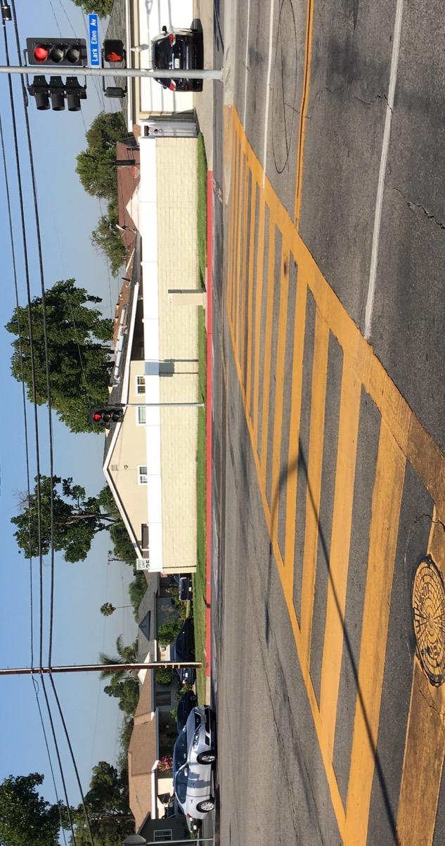
3 The half-day training is designed to provide participants with both pedestrian and bicycle safety best practices and a range of proven strategies (the 6 E s: Empowerment & Equity, Evaluation, Engineering, Enforcement, Education, and Encouragement) to address and improve pedestrian and bicycle safety conditions and concerns. Participants are then guided on a walkability and bikeability assessment of nearby streets before setting pedestrian and bicycle safety priorities and actionable next steps for their community. For a summary of outcomes from past CPBST workshops, please visit: and Selected Pedestrian & Bicycle Safety Conditions in the Azusa Unified School District High Speeds & Wide Streets The posted speed limits along Arrow Highway, Azusa Avenue, and Lark Ellen Avenue near the workshop location are 45, 40, and 40 miles per hour (MPH) respectively; however, Cal Walks staff observed drivers traveling at much higher speeds during the site visit and workshop. Drivers also appear to exceed the 25 mph speed limit on residential streets in the school zones for Gladstone High School, Ellington Elementary, and Valleydale Elementary Schools. Arrow Highway, Azusa Avenue, Lark Ellen Avenue measure from 58 feet to over 80 feet in curb-to-curb width with two travel lanes in each direction, a stripped center left turn lane or dedicated left turn lane, parallel parking in various locations along one side of the street, sidewalks, and a mix of unmarked and marked crossings. Intermittently, frontage roads are found along both sides of Arrow Highway and along the west side of Lark Ellen Avenue near the Gladstone High School. Research has demonstrated that wide streets and wide travel lanes are associated with higher vehicle speeds 1, which affect the safety of people walking and bicycling. Wide vehicle lanes on Lark Ellen Avenue. 1 See Kay Fitzpatrick, Paul Carlson, Marcus Brewer, and Mark Wooldridge, Design Factors That Affect Driver Speed on Suburban Arterials": Transportation Research Record 1751 (2000):

4 Lack of Bicycle Facilities No bicycle lanes exist in the Gladstone High School area, but Cal Walks staff observed bicyclists riding along Arrow Highway and Lark Ellen Avenue in the travel lane, on the sidewalk, and on frontage roads. Not only did the area surrounding Gladstone High School lack bicycle infrastructure but the area also lacks safe and comfortable connections to existing off-street bicycle trails in neighboring communities. During the workshop, County representatives confirmed plans to add bicycle facilities in the near future along the Big Dalton Wash that runs through Covina and connects to nearby bicycle routes and off-street trails. A bicyclist rides east along Arrow Highway towards Azusa Avenue. Inadequate Enhancements for Marked Pedestrian Crossings and Unmarked Crossings During the site visit, Cal Walk staff observed marked and unmarked crosswalks near Gladstone High School, Valleydale Elementary, and Ellington Elementary. High-visibility marked crosswalks exist observed on Lark Ellen Avenue and Tudor Street; on Aspan Avenue near Ellington Elementary School; and on Enid Avenue near Valleydale Elementary School. All crossings along Enid Avenue near Gladstone High School are unmarked (Alcross Street, Bygrove Street, Gragmont Street, Devanah Street, Nubia Street, and Groverdale Street). 3


5 An unmarked crossing along Enid Avenue in front of Gladstone High School. A standard marked crosswalk at Enid Avenue and Arrow Highway is difficult to see by pedestrians and vehicles. Pedestrian and Driver Behaviors at Marked and Unmarked Crossings Cal Walk staff observed drivers blocking the length of Enid Avenue in front of Gladstone High School during morning school arrival hours, while students crossed the street outside of the unmarked crossing, in the middle of the intersection, or between cars. The lack of any marked crosswalks and pedestrian crossing signage along Enid Avenue encourages unsafe driver and pedestrian behaviors. All crossings at Arrow Highway and Enid Avenue are standard marked crosswalks and the intersection has a traditional design. During school dismissal, large groups of students gather on the sidewalk at the intersection and wait to cross. Once the pedestrian crossing signal phase begins, students continue crossing beyond the allotted pedestrian signal timing, indicating that the crossing phase timing may not be sufficient. Additionally, drivers, turn right or left onto Arrow Highway through breaks in groups of students crossing the street, thereby not respecting the pedestrian signal or the right-of-way of the students crossing. Gladstone High School students cross in between vehicles on Enid Avenue, an unmarked crossing is just outside of the frame of the photo. 4


6 Missing Sidewalks & Sidewalks in Disrepair Due to the location of Gladstone High School, at the junction of three jurisdictions Covina, Azusa, and unincorporated Los Angeles County sidewalks vary in width and condition when they exist. The east side of Enid Avenue from Arrow Highway to Nubia Street has sidewalks buffered by a landscaping/planting strip, but they are too narrow for two adults to walk comfortably side-by-side. The west side of Enid Avenue, in unincorporated Los Angeles County, does not have sidewalks at all, and overgrown vegetation, shrubs, and fencing extend out into the street, often forcing students to walk directly in the roadway. Shade is only available from Nubia Street to Gragmont Street on the east side of Enid Avenue, where the landscape buffer contains shade trees; the rest of the east side of Enid Avenue is unshaded although there is a landscape buffer. At Gragmont Street and Enid Avenue the sidewalk is upheaved from expanding tree roots. An unmarked crossing with a drainage channel in the crossing zone on Enid Avenue and Bygrove Street. An uplifted sidewalk segment on Enid Avenue in front of Gladstone High School. 5

7 Lack of Pedestrian-Scale Lighting Cal Walks staff observed a lack of pedestrian-scale lighting, especially near the commercial center at Azusa Avenue and Arrow Highway and near Valleydale Elementary, Ellington Elementary, and Gladstone High School. Pedestrian-scale lighting is also missing near transit stops and shelters along Arrow Highway. Lack of pedestrian-scale lighting at bus shelters and transit stops along Arrow Highway. Pedestrian & Bicycle Collision History Between , 2 there were 87 pedestrian collisions in the City of Azusa, including four (4) fatalities and ten (10) severe injuries, with collisions concentrated on Foothill Boulevard and Azusa Avenue. 56.2% of these pedestrian collisions can be attributed to a driver violation, while 16.1% of pedestrian collisions can be attributed to a pedestrian violation. Over the 10-year period between , pedestrian collisions appear to be on an upward trajectory, except during the most recent recorded year, where collisions decreased. Between , there were 136 bicycle collisions in the City of Azusa, including one (1) fatality and ten (10) severe injuries, with collisions concentrated on Foothill Boulevard, Azusa Avenue, and San Gabriel Avenue. For bicycle collisions, 16% are attributed to a right-of-way violation either by a bicyclist or driver and 15.3% are attributed to improper turning either by a bicyclist or driver, and 15.3% are attributed to bicyclists riding on the wrong side of the road. Over the 10-year period between , bicycle collisions appear to be on a downward trajectory. UC Berkeley SafeTREC also conducted additional collision analysis of schools of interest in the Azusa Unified School District. Between , there were ten (10) pedestrian and bicycle collisions around Gladstone High School, including two (2) pedestrian fatalities. Between , there were ten (10) pedestrian and bicycle collisions near Ellington Elementary School, including one (1) pedestrian fatality. Between , there were 19 pedestrian and bicycle collisions around Center Middle School, including one (1) fatality and two (2) sever injuries. Between , there were 17 2 Please note 2014 and 2015 data is provisional. 6

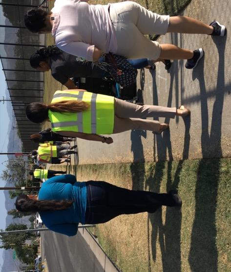
8 pedestrian and bicycle collisions near Valleydale Elementary School, including one (1) fatality and three (3) severe injuries. Of these collisions, nineteen (19) involved school-aged children. A full discussion of the pedestrian and bicyclist collision data prepared by UC Berkeley SafeTREC can be found Appendix A. August 30, 2017 Workshop Healthy Azusa requested a workshop to 1) provide City/County staff, community organizations, and residents with a toolkit for promoting pedestrian and bicycle safety to inform future active transportation projects and safe routes to school in the Azusa Unified School District; 2) strengthen working relationships between the school district staff and board members, Bike San Gabriel Valley, the YMCA, local law enforcement agencies and other stakeholders to ensure the best outcomes for the residents of Azusa, Covina and unincorporated Los Angeles County; and 3) develop consensus regarding pedestrian and bicycle safety priority and actionable next steps. Azusa Mayor Joseph Rocha welcoming workshop participants. The workshop was hosted from 7:30 am to 1:00 pm, with lunch and simultaneous English to Spanish interpretation provided by the Azusa Unified School District to maximize community participation. Forty-three (43) individuals attended the workshop, including Azusa Mayor Joe Rocha, Covina Mayor Jorge Marquez, representatives from the City of Azusa, Los Angeles County Board Supervisor Hilda Solis office, Azusa Unified School District, Los Angeles County Sheriff s Department, Healthy Azusa, the Valleydale and Ellington Elementary School Principals, Gladstone High School staff, Bike San Gabriel Valley, and numerous residents and parents. The workshop also included an optional observation of school arrival conditions at Gladstone High School. 7

9 Reflections from Walkability & Bikeability Assessment Workshop participants conducted walkability and bikeability assessments along 3 routes: Route 1 traveled north from Gladstone High School towards Arrow Highway, west towards Lark Ellen Avenue, north towards Woodcroft Street, east towards Enid Avenue, north towards Newburgh Street, and south towards Gladstone High School. Route 1 focused on Arrow Highway and the area around Valleydale Elementary School. Route 2 traveled north from Gladstone High School towards Arrow Highway, east on one side of Arrow Highway towards Azusa Avenue, west on the other side of Arrow Highway, and south on Enid Avenue towards Gladstone High School. Route 2 focused on Arrow Highway between Enid Avenue and Azusa Avenue, a common destination for students on their way home from school. Route 3 traveled south from Gladstone High School towards Tudor Street, west along Tudor Street across Lark Ellen Avenue to Aspan Avenue, north along Aspan Avenue to Groverdale, east on Groverdale to Lark Ellen Avenue, south on Lark Ellen Avenue to Tudor Avenue, east along Tudor Avenue to Enid Avenue, and north on Enid Avenue to Gladstone High School. Route 3 focused on Tudor Street, crossings on Lark Ellen Avenue, and the area around Ellington Elementary. Participants were asked to 1) observe infrastructure conditions and the behavior of all road users; 2) apply strategies learned from the 6 E s presentation that could help overcome infrastructure concerns and unsafe driver, pedestrian, and bicyclist behavior; and 3) identify positive community assets and strategies which can be built upon. Following the walkability and bikeability assessment, the participants shared the following reflections: Lack of Sidewalks and Poor Sidewalk Conditions: Sidewalks are continuous along larger thoroughfares like Arrow Highway, Azusa Avenue, and Lark Ellen Avenue in the workshop area, but small residential streets like Enid Avenue, Woodcroft Street, and Tudor Street are missing sidewalks leading up to the schools. Residents noted that there are no sidewalks on the west side of Enid Avenue across from Gladstone High School, and the sidewalks on the east side of Enid Avenue are too narrow for two adults to walk side-byside or pass comfortably. They also noted that during school dismissal, students walk in large groups and spill over into the street along the east side of Enid Avenue. The lack of continuous sidewalks is a major deterrent for Valleydale and Ellington Elementary parents to allow their students to walk or bike to school. Overgrown vegetation blocks the walking path along the County portion of Enid Avenue. 8


10 Although there are shade trees and sidewalk landscape buffers along the main thoroughfares, the community noted there are large segments of sidewalks that offered no shade due to small trees with little foliage and landscape areas with missing trees. In some areas, overgrown vegetation from nearby homes narrowed the walking path and left debris. Participants noted sidewalks along Arrow Avenue on Route 2 are sufficiently wide, buffered from vehicle traffic, shaded, and clean. An empty landscape buffer on Enid Avenue adjacent to Gladstone High School creates a sunny walking path. Tree wells in front of Ellington Elementary School have been paved over. School Zone Signage: Participants on Route 1 and 2 noted there are no School Zone signs along Arrow Highway on the Covina side and it is difficult for fast moving vehicle traffic to identify the Gladstone High School marquee. Gladstone Principal Chris Silvas shared during the workshop that he expects a new, more visible marquee to be installed by the District within a year which should help make the school more visible to passing vehicles. Lack of Bicycle Facilities: Participants noted a lack of bicycle infrastructure such as bicycle lanes and bicycle route signage throughout the workshop area. Despite this, several bicyclists were observed during the assessment riding on Arrow Highway. Participants expressed concern about riding in the roadway due to the high speed of vehicle traffic. Lack of Marked & Enhanced Marked Crossings: The standard marked crossings along Arrow Highway and Azusa Avenue are faded, with standard markings and require pedestrians to cross 5 lanes of vehicle traffic with few pedestrian crossing enhancements. Participants noted a lack of current ADA curb ramps along Arrow Highway. Participants who walked Route 1 toward Valleydale Elementary expressed concern over the lack of marked crossings at Enid Avenue and Woodcroft Street. Bus Shelter at Enid Avenue and Arrow Highway: The bus shelter on the northeast corner of Arrow Highway at Enid Avenue is located too close to the corner nearest Gladstone High 9

11 School. Participants noted there is often not enough space to wait. Further, the bench next to the bus shelter does not provide sufficient shade and is not well-lit at night. Pedestrian and Vehicle Conflicts at Enid Avenue and Arrow Highway: The intersection of Enid Avenue and Arrow Highway experiences pedestrian-vehicle conflicts, especially during Gladstone High School arrival and dismissal times. Participants expressed concern for students using the western crosswalk on Arrow Highway due to vehicles turning left onto Arrow Highway. As students cross in large groups, vehicles attempt to turn left in between groups of students. Similarly, as students cross in the eastern crosswalk on Arrow Highway, right-turning vehicles attempt to turn in between groups of students. Community Resident Recommendations Following the walkability and bikeability assessment, Cal Walks facilitated small-group action planning discussions. Workshop participants discussed two sets of questions: the first focused on identifying and prioritizing non-infrastructure community-led programs that can be sustained with little or no funding. The second focused on prioritizing infrastructure improvements in Azusa and identifying priority projects for Azusa and Los Angeles County. Participants engaged in small group action planning discussions. Workshop participants provided the following recommendations for overall pedestrian and bicyclist safety improvements: Non-Infrastructure Priorities & Recommendations Expand and Support Existing Safe Routes to School Efforts: Participants would like to support Safe Routes to School (SRTS) efforts by highlighting community members who are already engaged in SRTS work and building capacity for future projects. They would like to apply for an SRTS education and encouragement grant through the Active Transportation Program (ATP) to expand and build programs across the Azusa Unified School District. 10

12 Healthy Azusa, District staff, and parents have already conducted Safe Routes to School assessments for elementary schools in the District, and they would like to expand the existing Walk to School Day walking school bus program to a bi-annual program potentially during Bike to School Day in May to complement the current annual event during Walk to School Day in October. Los Angeles County Public Works representatives shared Safe Routes to School maps for nearby elementary schools with preferred walking routes during the workshop, and workshop participants hoped to use these maps to support current walking school bus efforts. The program can also be support by allowing student volunteer hours to be used during SRTS events. Participants also discussed the need to develop SRTS programs that are relevant and engaging to older junior high and high school students. A funded SRTS program would support the formation of an SRTS Task Force and school champions that can develop sustainable SRTS programs with little or no funding. Participants would like to add active transportation education messaging throughout the community by taking advantage of the Southern California Association of Government s (SCAG) Go Human campaign, which provides lawn signs with safety education messages to school districts and cities. They would also like to prioritize adding pedestrian safety messages on sidewalks where students are likely to walk. Additional SRTS education efforts will focus on teaching safe walking and biking skills at a young age and providing helmet safety programs to the community. Infrastructure Priorities & Recommendations Sidewalk Installation: Participants highlighted the need to install sidewalks in the workshop area, especially near schools and places where students are likely to walk. Priority locations identified by participants include the west side of Enid Avenue from Arrow Highway to Tudor Street and the east side of Enid Avenue from Arrow Highway leading to Valleydale Elementary School. Residents also expressed the need to address overgrown vegetation along existing sidewalks and walking paths. Los Angeles County Public Works staff recommended residents use the County s SeeClickFix online and mobile reporting system. A well-worn walking path on the east side of Enid Avenue leading to Valleydale Elementary. 11

13 School Zone Signage: Participants called for the installation of a school zone sign on the City of Covina segment of Arrow Highway to signal to drivers to expect students in the area. Crossing Enhancements: Throughout the workshop area and particularly at intersections near schools, participants noted crossing challenges due to faded standard transverse crosswalks, lack of bulb-outs/curb extensions, lack of ADA compliant ramps, and other traffic calming measures. Participants recommend the installation of high-visibility crosswalks near schools and across Arrow Highway, bulb-outs at Enid Avenue and Arrow Highway. Parents of Valleydale Elementary School students were also interested in the installation of a Rectangular Rapid Flash Beacon (RRFB) at the intersection of Enid Avenue and Woodcroft Street. Lastly, many workshop participants identified the installation of a dedicated left-turn signal for drivers on Arrow Highway and Enid Avenue as their top priority to improve safety. Los Angeles County Public Works staff shared with participants that the County is already planning on making the requested improvement and provided a project timeline with an expected completion of no later than December A high-visibility crosswalk at Aspan Avenue and Tudor Street across from Ellington Elementary. Additional Street & Pedestrian-Scale Lighting: Participants recommended improving existing lighting conditions by installing additional street lighting and pedestrian-scale lighting, especially near schools. Currently, there are long stretches of both large arterials and residential streets with limited lighting. Parents shared that after-school programs extend into the evening and that they want their children to feel safer with lighting when such programs released students. Parents of Valleydale Elementary School also recommended adding pedestrian-scale lighting to the intersection of Woodcroft Street and Enid Avenue to improve safety for students and parents walking to school. California Walks/SafeTREC Recommendations California Walks and SafeTREC also submit the following recommendations for consideration by the Azusa Unified School District, City of Covina, City of Azusa, and Los Angeles County: City of Azusa, City of Covina, and Los Angeles County Traffic Calming Measures along Arrow Highway & Lark Ellen Avenue: Participants consistently identified Arrow Highway and Lark Ellen Avenue as two challenging streets for residents to cross and use while on foot or on bike. We recommend the County and Cities of Azusa and Covina collaborate to engage residents to identify long-term traffic calming measures, such as implementing a road diet, installing bulb-outs, enhanced crossings, transit-priority lanes, and physically-separated bicycle infrastructure, for consideration on Arrow Highway and Lark Ellen Avenue. Because of concerns around speed, it would be helpful for the county to gather speed data along Arrow Highway, Azusa Avenue, and Lark Ellen Avenue. These types of improvements can decrease vehicle speeds and improve safety for pedestrians, bicyclists, and drivers. We 12

14 recommend that the County engage the community in the Fall 2017/Winter 2018 in order to prepare an application to the state s Active Transportation Program in Spring Apply for Infrastructure Funds for Gladstone High School: Sidewalks are needed on the west side of Enid Avenue in unincorporated Los Angeles County and marked crossings are needed along Enid Avenue across from Gladstone High School in the County and City of Covina. Cal Walks and SafeTREC recommend continued collaboration between the School District, City of Covina, and LA County to apply for infrastructure funding for pedestrian safety improvements along Enid Avenue. Additionally, we recommend that the street owner(s) install a raised crossing with high-visibility crosswalk markings on the southern leg of the Enid Avenue and Devanah Street intersection. Example of raised crosswalk leading to a school in Eureka, CA. Photo Credit: Humboldt Partnership for Active Living Crossing Enhancements at Enid Avenue and Arrow Highway: Signal timing during school arrival and dismissal hours should be observed and retimed across Arrow Highway at Enid Avenue to allow a walking pace of no more than 2.8 per second near the schools to help students and parents cross safely. We recommend that City/County staff collaborate to do a district-wide analysis of pedestrian signal timing at intersections near schools. We also recommend the City/County consider enabling a leading pedestrian interval(lpi) when the left-turn signal is installed by the County in December Other crossing safety enhancements such as bulb outs should be considered to shorten the crossing distance and time for pedestrians. Pedestrian refuge islands on Arrow Highway would also allow pedestrians to stop at the halfway point and finish crossing the street on the next pedestrian walk signal. Pedestrian refuge islands provide a safe place to stop for seniors, students, parents with small children, and others with limited mobility. 13
15 Azusa Unified School District Improve Gladstone High School Pick-Up and Drop-Off Zone: Cal Walks and Planning Committee members conducted observations of student arrival hours prior to the workshop. In the school drop-off zone, drivers failed to move forward in the school arrival and departure parking lot but concentrated in the area near the Main Office gate, creating a vehicle backup onto Enid Avenue. Drivers in the drop-off zone also doubleparked, resulting in students having to walk between vehicles to get to the sidewalk. Cal Walks and SafeTREC recommend restriping the drop-off zone to create two dedicated drop-off lanes and installing signage instructing drivers to pull forward and watch for passing students. Additionally, we recommend that the School District collaborate with Healthy Azusa to launch a student safety patrol program that can help assist with managing the drop-off zone area. Establish a District Safe Routes to School Task Force: The Azusa Unified School District, although based in Azusa, serves students in the City of Azusa, City of Covina, City of Glendora, and unincorporated LA County. Cal Walks and SafeTREC recommend the District establish a SRTS Task Force to engage all jurisdictions and in more frequent communication with one another and with residents, parents, and other SRTS champions. Develop Community Bicycle Plan: Although there are some bicycle facilities in each of the jurisdictions, more and improved bicycling facilities and wayfinding are needed to ensure safety for students and community members along Arrow Highway, Lark Ellen Avenue, and Azusa Avenue. Wayfinding is needed to direct cyclists to existing and preferred bike routes. Cal Walks and SafeTREC recommend the District and City of Azusa collaborate and pursue funding for the development of a bicycle plan to identify bicycle infrastructure needs and develop a bikeway planning guide. Acknowledgments We would like to thank Healthy Azusa and Maria-Inez Perez for inviting us into their community and the Azusa Unified School District and Gladstone High School for hosting the Community Pedestrian and Bicycle Safety Training. We would like to acknowledge the many community members and agencies present at the workshop and their dedication to pedestrian and bicycle safety. Their collective participation meaningfully informed and strengthened the workshop s outcomes. Funding for this program was provided by a grant from the California Office of Traffic Safety through the National Highway Traffic Safety Administration. 14
16 Appendix A Pedestrian and Bicycle Collision Data Analysis
17 Community Pedestrian and Bicyclist Safety Workshop Azusa, CA 8/30/17 Pedestrian and Bicycle Collision Analyses, * PEDESTRIANS Number of Collisions Involving Pedestrians, The blue line shows the number of pedestrian collisions where a fatality and/or injury occurred. There were 189 people injured or killed in 174 pedestrian collisions over the last 10 years. The green line shows the three-year moving average of the number of pedestrian collisions where a fatality and/or injury occurred. The moving average is useful for tracking trend change over time, especially when the number of collisions is subject to variability. Data points are the midpoint of the three years of data specified. The following analyses are based on the most current five years, 2011 to 2015, of data for Azusa, CA. There were 94 people killed or injured in 87 pedestrian collisions. Top Violation Types for Collisions Involving Pedestrians Type of Violation Collisions N(%) Driver must yield pedestrian right of way in a crosswalk 34 (39.1%) Pedestrian yield, upon roadway outside crosswalk 14 (16.1%) Sidewalk, failure to yield to pedestrian on. 7 (8.0 Unsafe speed for prevailing conditions (use for all prima facie limits) 5 (5.7%) Unsafe turn with/without signaling. 3 (3.4%) Other violation* 24 (27.6%) Total 87 (100.0%) * Note: Each violation type accounted for two or fewer collisions. Pedestrian Actions in Collisions Involving Pedestrians Pedestrian Action Collisions N(%) Crossing in Crosswalk at Intersection 41 (47.1%) Crossing Not in Crosswalk 24 (27.6%) Not in Road 9 (10.3%) In Road, Including Shoulder 7 (8.0%) Not Stated 4 (4.6%) Crossing in Crosswalk Not at Intersection 2 (2.3%) Total 87(100.0%) * Data Source: California Statewide Integrated Traffic Records System (SWITRS). Collision data for 2014 and 2015 are provisional at this time. Funding for this project was provided by a grant from the California Office of Traffic Safety through the National Highway Traffic Safety Administration.
18 Community Pedestrian and Bicyclist Safety Workshop Azusa, CA 8/30/17 Pedestrian and Bicycle Collision Analyses, * Pedestrian Victim Demographics The age of pedestrian victims ranged considerably across all age groups, with youth age 19 or younger accounting for 40.4 percent of all victims. The majority of victims were male Number of Victims (n) (20.2%) 19 (20.2%) 9 (9.6%) 14 (14.9%) 19 (20.2%) 14 (14.9%) 14 or younger 15 to to to to or older Victim Age Victim Injury Severity, Most collisions resulted in minor injuries. Complaint of Pain 40 (42.6%) Fatal 4 (4.3%) Severe Injury 10 (10.6%) Not Stated 10 (10.6%) Other Visible Injury 40 (42.6%) Female 39 (41.5%) Male 45 (47.9%) * Data Source: California Statewide Integrated Traffic Records System (SWITRS). Collision data for 2014 and 2015 are provisional at this time. Funding for this project was provided by a grant from the California Office of Traffic Safety through the National Highway Traffic Safety Administration.
19 Community Pedestrian and Bicyclist Safety Workshop Azusa, CA 8/30/17 Pedestrian and Bicycle Collision Analyses, * BICYCLISTS Number of Collisions Involving Bicyclists, The blue line shows the number of bicycle collisions where a fatality and/or injury occurred. There were 260 people killed or injured in 251 bicycle collisions over the last 10 years. The green line shows the three-year moving average of the number of bicycle collisions where a fatality and/or injury occurred. The moving average is useful for tracking trend change over time, especially when the number of collisions is subject to variability. The following analyses are based on the most current five years, 2011 to 2015, of data for Azusa, CA. There were 136 people killed or injured in 131 bicycle collisions. Top Violation Types for Collisions Involving Bicycles Type of Violation Collisions N (%) Automobile Right of Way 21 (16.0%) Wrong Side of Road 20 (15.3%) Improper Turning 17 (13.0%) Traffic Signals and Signs 14 (10.7%) Unsafe Speed 7 (5.3%) Pedestrian Right of Way 7 (5.3%) Unknown or not stated 25 (19.1%) Other Violation* 20 (15.3%) Total 131 (100.0%) *Each violation type was reported five or fewer times. * Data Source: California Statewide Integrated Traffic Records System (SWITRS). Collision data for 2014 and 2015 are provisional at this time. Funding for this project was provided by a grant from the California Office of Traffic Safety through the National Highway Traffic Safety Administration.
20 Community Pedestrian and Bicyclist Safety Workshop Azusa, CA 8/30/17 Pedestrian and Bicycle Collision Analyses, * Bicycling Victims Demographics The age of bicycling collision victims varied across all age groups, with youth age 19 or younger accounting for over one-third of victims. Victims were primarily male. 80 Number of Victims (n) (14.0%) 32 (23.5%) 14 (10.3%) 31 (22.8%) 31 (22.8%) 7 (5.1%) 2 (1.5%) 14 or younger 15 to to to to or older Unknown Victim Age Victim Injury Severity, Most collisions resulted in minor injuries. Complaint of Pain 42 (30.9%) Fatal 1 (0.7%) Severe Injury 10 (7.3%) Female 18 (13.2%) Not Stated 9 (6.7%) Other Visible Injury 83 (61.0%) Male 109 (80.1%) * Data Source: California Statewide Integrated Traffic Records System (SWITRS). Collision data for 2014 and 2015 are provisional at this time. Funding for this project was provided by a grant from the California Office of Traffic Safety through the National Highway Traffic Safety Administration.
21 Community Pedestrian and Bicyclist Safety Workshop Azusa, CA 8/30/17 Pedestrian and Bicycle Collision Analyses, * Pedestrian Collision Locations, Note: Only 81 of 87 collisions are geo-coded. * Data Source: California Statewide Integrated Traffic Records System (SWITRS). Collision data for 2014 and 2015 are provisional at this time. Funding for this project was provided by a grant from the California Office of Traffic Safety through the National Highway Traffic Safety Administration.
. Collision data for 2014 and 2015 are provisional at this time.")
22 Community Pedestrian and Bicyclist Safety Workshop Azusa, CA 8/30/17 Pedestrian and Bicycle Collision Analyses, * Bicyclist Collision Locations, Note: Only 103 of 131 collisions are geo-coded. * Data Source: California Statewide Integrated Traffic Records System (SWITRS). Collision data for 2014 and 2015 are provisional at this time. Funding for this project was provided by a grant from the California Office of Traffic Safety through the National Highway Traffic Safety Administration.

23
24 Community Pedestrian and Bicyclist Safety Workshop Covina, CA August 30, 2017 Pedestrian and Bicycle Collision Analyses, * PEDESTRIANS Number of Collisions Involving Pedestrians, The blue line shows the number of pedestrian collisions where a fatality and/or injury occurred. There were 131 people injured or killed in 118 pedestrian collisions over the last 10 years. The green line shows the three-year moving average of the number of pedestrian collisions where a fatality and/or injury occurred. The moving average is useful for tracking trend change over time, especially when the number of collisions is subject to variability. Data points are the midpoint of the three years of data specified. The following analyses are based on the most current five years, 2011 to 2015, of data for Covina, CA. There were 64 people killed or injured in 56 pedestrian collisions. Top Violation Types for Collisions Involving Pedestrians Type of Violation Collisions N (%) Driver must yield pedestrian right of way in a crosswalk 27 (48.21%) Pedestrian yield, upon roadway outside crosswalk 8 (14.29%) Other 7 (12.50%) Red or Stop, vehicles stop at limit line or X-walk. 3 (5.36%) Jaywalking, between signal controlled intersections. 2 (3.57%) Unsafe turn with/without signaling. 2 (3.57%) Walk pedestrian failure to yield right-of-way to vehicles already in crosswalk. 2 (3.57%) Other Violation 12 (8.95%) Total 56 (100.02%) Pedestrian Actions in Collisions Involving Pedestrians Pedestrian Action Collisions N (%) Crossing in Crosswalk at Intersection 34 (60.71%) Crossing Not in Crosswalk 16 (28.57%) Not in Road 3 (5.36%) In Road, Including Shoulder 2 (3.57%) Crossing in Crosswalk Not at Intersection 1 (1.79%) * Data Source: California Statewide Integrated Traffic Records System (SWITRS). Collision data for 2014 and 2015 are provisional at this time. Funding for this project was provided by a grant from the California Office of Traffic Safety through the National Highway Traffic Safety Administration.
25 Community Pedestrian and Bicyclist Safety Workshop Covina, CA August 30, 2017 Pedestrian and Bicycle Collision Analyses, * Total 56 (100.0%) Pedestrian Victim Demographics The age of pedestrian victims ranged considerably across all age groups, but adults 45 to 64 accounted for 26.6% percent of all victims. Victims were primarily male. 20 Number of Victims (n) (26.6%) 8 (12.5%) 14 or younger 15 to to to to or older Victim Age Victim Injury Severity, Most collisions resulted in minor injuries. Killed 1 Severe Injury 5 (7.81%) Not Stated 4 (6.25%) Complaint of Pain 30 (46.88%) Other Visible Injury 28 (43.75%) Female 26 (40.63%) Male 34 (53.13%) * Data Source: California Statewide Integrated Traffic Records System (SWITRS). Collision data for 2014 and 2015 are provisional at this time. Funding for this project was provided by a grant from the California Office of Traffic Safety through the National Highway Traffic Safety Administration.
26 Community Pedestrian and Bicyclist Safety Workshop Covina, CA August 30, 2017 Pedestrian and Bicycle Collision Analyses, * BICYCLISTS Number of Collisions Involving Bicyclists, The blue line shows the number of bicycle collisions where a fatality and/or injury occurred. There were 113 people injured in 113 bicycle collisions over the last 10 years. The green line shows the three-year moving average of the number of bicycle collisions where a fatality and/or injury occurred. The moving average is useful for tracking trend change over time, especially when the number of collisions is subject to variability. The following analyses are based on the most current five years, 2011 to 2015, of data for Covina, CA. There were 47 people injured in 47 bicycle collisions. Top Violation Types for Collisions Involving Bicycles Type of Violation Collisions N (%) Wrong Side of Road 26 (55.32%) Traffic Signals and Signs 5 (10.64%) Improper Turning 4 (8.51%) Other Hazardous Violation 3 (6.38%) Automobile Right of Way 3 (6.38%) Other Violation 5 (10.64%) Unknown 1 (2.13%) Total 47 (100.1%) * Data Source: California Statewide Integrated Traffic Records System (SWITRS). Collision data for 2014 and 2015 are provisional at this time. Funding for this project was provided by a grant from the California Office of Traffic Safety through the National Highway Traffic Safety Administration.
27 Community Pedestrian and Bicyclist Safety Workshop Covina, CA August 30, 2017 Pedestrian and Bicycle Collision Analyses, * Bicycling Victims Demographics The age of bicycling collision victims varied across all age groups, with youth age 14 or younger accounting for percent of victims. The majority of victims were male. 15 Number of Victims (n) (25.53%) 9 (19.15%) 7 2 (4.26%) (19.15%) (17.02%) (14.89%) 14 or younger 15 to to to to or older Victim Age Victim Injury Severity, Most collisions resulted in minor injuries. Severe Injury 2 (4.26%) Female 4 (8.51%) Not Stated 1 (2.13%) Other Visible Injury 15 (31.91%) Complaint of Pain 30 (63.83%) Male 42 (89.36%) * Data Source: California Statewide Integrated Traffic Records System (SWITRS). Collision data for 2014 and 2015 are provisional at this time. Funding for this project was provided by a grant from the California Office of Traffic Safety through the National Highway Traffic Safety Administration.
28 Community Pedestrian and Bicyclist Safety Workshop Covina, CA August 30, 2017 Pedestrian and Bicycle Collision Analyses, * Pedestrian Collision Locations, Note: Only 48 of 56 collisions are geo-coded. * Data Source: California Statewide Integrated Traffic Records System (SWITRS). Collision data for 2014 and 2015 are provisional at this time. Funding for this project was provided by a grant from the California Office of Traffic Safety through the National Highway Traffic Safety Administration.
. Collision data for 2014 and 2015 are provisional at this time.")
29 Community Pedestrian and Bicyclist Safety Workshop Covina, CA August 30, 2017 Pedestrian and Bicycle Collision Analyses, * Bicyclist Collision Locations, Note: Only 39 of 47 collisions are geo-coded. * Data Source: California Statewide Integrated Traffic Records System (SWITRS). Collision data for 2014 and 2015 are provisional at this time. Funding for this project was provided by a grant from the California Office of Traffic Safety through the National Highway Traffic Safety Administration.

30
Recommendations to Improve Pedestrian & Bicycle Safety for the Missouri Flat Area (El Dorado County)
") Recommendations to Improve Pedestrian & Bicycle Safety for the Missouri Flat Area (El Dorado County) October 2017 Recommendations to Improve Pedestrian & Bicycle Safety for the Missouri Flat Area (El Dorado
Recommendations to Improve Pedestrian & Bicycle Safety for the Missouri Flat Area (El Dorado County) October 2017 Recommendations to Improve Pedestrian & Bicycle Safety for the Missouri Flat Area (El Dorado
RECOMMENDATIONS TO IMPROVE PEDESTRIAN & BICYCLE SAFETY IN THE COMMUNITY OF FLORENCE-FIRESTONE
 RECOMMENDATIONS TO IMPROVE PEDESTRIAN & BICYCLE SAFETY IN THE COMMUNITY OF FLORENCE-FIRESTONE September 2017 By Miha Tomuta, Wendy Ortiz, California Walks; Jill Cooper, Katherine Chen, UC Berkeley SafeTREC
Recommendations to Improve Pedestrian & Bicycle Safety for the Community of Southwest Fresno
 Recommendations to Improve Pedestrian & Bicycle Safety for the Community of Southwest Fresno October 2017 Recommendations to Improve Pedestrian & Bicycle Safety for the Community of Southwest Fresno By
Recommendations to Improve Pedestrian & Bicycle Safety for the Community of North Shore
 Recommendations to Improve Pedestrian & Bicycle Safety for the Community of North Shore October 2017 Recommendations to Improve Pedestrian & Bicycle Safety for the Community of North Shore By Tony Dang,
Recommendations to Improve Pedestrian & Bicycle Safety for the Community of Palermo
 Recommendations to Improve Pedestrian & Bicycle Safety for the Community of Palermo September 2017 Recommendations to Improve Pedestrian & Bicycle Safety for the Community of Palermo By Wendy Ortiz, Jaime
Recommendations to Improve Pedestrian & Bicycle Safety for the Arden-Arcade Community
 Recommendations to Improve Pedestrian & Bicycle Safety for the Arden-Arcade Community June 2018 Acknowledgements Planning Committee Joelle Orrock Gail Kelly Molly Patterson Dan Allison Heather Yee Molly
RECOMMENDATIONS TO IMPROVE PEDESTRIAN & BICYCLIST SAFETY IN LOS ANGELES CHINATOWN
 RECOMMENDATIONS TO IMPROVE PEDESTRIAN & BICYCLIST SAFETY IN LOS ANGELES CHINATOWN October 2016 By Tony Dang, Caro Jauregui, Jaime Fearer, Wendy Alfsen, California Walks; Jill Cooper, Katherine Chen, UC
RECOMMENDATIONS TO IMPROVE PEDESTRIAN & BICYCLIST SAFETY FOR THE MOUNTAIN VIEW SCHOOL DISTRICT (EL MONTE/SOUTH EL MONTE)
") RECOMMENDATIONS TO IMPROVE PEDESTRIAN & BICYCLIST SAFETY FOR THE MOUNTAIN VIEW SCHOOL DISTRICT (EL MONTE/SOUTH EL MONTE) August 2016 By Caro Jauregui, Jaime Fearer, Tony Dang, Wendy Alfsen California Walks;
RECOMMENDATIONS TO IMPROVE PEDESTRIAN & BICYCLIST SAFETY FOR THE MOUNTAIN VIEW SCHOOL DISTRICT (EL MONTE/SOUTH EL MONTE) August 2016 By Caro Jauregui, Jaime Fearer, Tony Dang, Wendy Alfsen California Walks;
Recommendations to Improve Pedestrian & Bicycle Safety for the City of Arvin
 Recommendations to Improve Pedestrian & Bicycle Safety for the City of Arvin July 2018 1 Acknowledgements Planning Committee Jack Becker Tammy Fisher Pat Ebel Peter Smith Carlos Bello Christine Viterelli
Recommendations to Improve Pedestrian & Bicycle Safety for the Zane Middle School Community
 Recommendations to Improve Pedestrian & Bicycle Safety for the Zane Middle School Community October 2018 1 Acknowledgements Planning Committee Nicole Sager Jesse Willor Jenny Weiss Emily Sinkhorn Scott
RECOMMENDATIONS TO IMPROVE PEDESTRIAN & BICYCLE SAFETY IN ROSEMONT
 RECOMMENDATIONS TO IMPROVE PEDESTRIAN & BICYCLE SAFETY IN ROSEMONT SEPT 2017 By Tony Dang, Jaime Fearer, Miha Tomuta, Wendy Ortiz, California Walks; Jill Cooper, Jessica Rosas, UC Berkeley SafeTREC Recommendations
RECOMMENDATIONS TO IMPROVE PEDESTRIAN SAFETY IN MCKINLEYVILLE
 RECOMMENDATIONS TO IMPROVE PEDESTRIAN SAFETY IN MCKINLEYVILLE May 2015 By Tony Dang, Jaime Fearer, Wendy Alfsen, California Walks; Jill Cooper, UC Berkeley SafeTREC Recommendations to Improve Pedestrian
Recommendations to Improve Pedestrian & Bicycle Safety for the Clegg Elementary School & Stacey Middle School Community
 Recommendations to Improve Pedestrian & Bicycle Safety for the Clegg Elementary School & Stacey Middle School Community (Westminster School District) October 2018 1 Acknowledgements Planning Committee
Recommendations to Improve Pedestrian & Bicycle Safety for the City of Bakersfield
 Recommendations to Improve Pedestrian & Bicycle Safety for the City of Bakersfield August 2018 1 Acknowledgements Planning Committee Jack Becker Bike Bakersfield Cindy Parra Bike Bakersfield Christopher
Recommendations to Improve Pedestrian & Bicycle Safety for the City of Hayward: Tennyson Road Corridor
 Recommendations to Improve Pedestrian & Bicycle Safety for the City of Hayward: Tennyson Road Corridor October 2018 1 Acknowledgments Planning Committee Charmine Solla Steven Chang Patty Garcia Sergio
Recommendations to Improve Pedestrian & Bicycle Safety for the Valley West Community in Arcata
 Recommendations to Improve Pedestrian & Bicycle Safety for the Valley West Community in Arcata October 2018 1 Acknowledgements Planning Committee Netra Khatri Julie Neander Emily Sinkhorn Jennifer Weiss
City of San Diego Vision Zero Draft Strategic Plan FY 2017
 City of San Diego Vision Zero Draft Strategic Plan FY 2017 Engineering Objective: To develop and implement a strategy that employs best planning, design and engineering practices. Background: Over the
RECOMMENDATIONS TO IMPROVE PEDESTRIAN & BICYCLIST SAFETY IN MODESTO S AIRPORT NEIGHBORHOOD
 RECOMMENDATIONS TO IMPROVE PEDESTRIAN & BICYCLIST SAFETY IN MODESTO S AIRPORT NEIGHBORHOOD August 2016 By Jaime Fearer, Caro Jauregui, Tony Dang, Wendy Alfsen, California Walks; Jill Cooper, UC Berkeley
PEDESTRIAN ACTION PLAN
 ATTACHMENT 2 CITY OF SANTA MONICA PEDESTRIAN ACTION PLAN CITY OF SANTA MONICA PEDESTRIAN ACTION PLAN This page intentionally left blank EXECUTIVE SUMMARY CHAPTER 1 EXECUTIVE SUMMARY Setting the Stage
RECOMMENDATIONS TO IMPROVE PEDESTRIAN & BICYCLIST SAFETY IN THE CITY OF SHASTA LAKE
 RECOMMENDATIONS TO IMPROVE PEDESTRIAN & BICYCLIST SAFETY IN THE CITY OF SHASTA LAKE October 2016 By Tony Dang, Jaime Fearer, Wendy Alfsen, California Walks; Jill Cooper, Jesus Barajas, UC Berkeley SafeTREC
C/CAG. Sunnybrae Elementary School Walking and Bicycling Audit. San Mateo-Foster City School District JUNE 2013
 Sunnybrae Elementary School Walking and Bicycling Audit JUNE 2013 San Mateo-Foster City School District C/CAG City/County Association of Governments of San Mateo County SUNNYBRAE ELEMENTARY SCHOOL WALKING
MAG Town of Cave Creek Bike Study Task 6 Executive Summary and Regional Significance Report
 Page 1 MAG Town of Cave Creek Bike Study Task 6 Executive Summary and Regional Significance Report August 1, 2012 MAG Project #481 Page 2 Task 6 Executive Summary and Regional Significance Report Introduction
July 5, Arthur R. Ware, Jr. Elementary School 2017 Safe Routes to School Walkabout Report
 July 5, 2017 Arthur R. Ware, Jr. Elementary School 2017 Safe Routes to School Walkabout Report 1 Walkabout Report Introduction On April 28, 2017, City, School, and SAWMPO staff met to conduct a Safe Routes
Recommendations to Improve Pedestrian & Bicycle Safety for the City of Lemon Grove
 Recommendations to Improve Pedestrian & Bicycle Safety for the City of Lemon Grove October 2018 1 Acknowledgements Planning Committee Anita Lopez Rosa Carney Steve Browne Angeles Nelson Lemon Grove Healthy
CITY OF OAK CREEK SAFE ROUTES TO SCHOOL ACTION PLAN. East Middle School
 CITY OF OAK CREEK SAFE ROUTES TO SCHOOL ACTION PLAN East Middle School CITY OF OAK CREEK SAFE ROUTES TO SCHOOL ACTION PLAN East Middle School Why Safe Routes to School? Safe Routes to School ( SRTS ) is
TRAFFIC ACTION PLAN. North Central Neighborhood CITY OF SAN MATEO
 TRAFFIC ACTION PLAN North Central Neighborhood CITY OF SAN MATEO Draft February 2017 Table of Contents Introduction... 1 The Traffic Forum Process... 4 Neighborhood Traffic Issues... 6 Neighborhood Recommendations
Chapter 14 PARLIER RELATIONSHIP TO CITY PLANS AND POLICIES. Recommendations to Improve Pedestrian Safety in the City of Parlier (2014)
") Chapter 14 PARLIER This chapter describes the current status and future plans for biking and walking in the City of Parlier. RELATIONSHIP TO CITY PLANS AND POLICIES The Parlier General Plan is the primary
Chapter 14 PARLIER This chapter describes the current status and future plans for biking and walking in the City of Parlier. RELATIONSHIP TO CITY PLANS AND POLICIES The Parlier General Plan is the primary
Hedgepeth Williams Middle School and Paul Robeson Elementary School Trenton, NJ. School Travel Plan
 Hedgepeth Williams Middle School and Paul Robeson Elementary School Trenton, NJ School Travel Plan Hedgepeth Williams Middle School Description: Hedgepeth-Williams Middle School is located at 301 Gladstone
Active Transportation Facility Glossary
 Active Transportation Facility Glossary This document defines different active transportation facilities and suggests appropriate corridor types. Click on a facility type to jump to its definition. Bike
Broad Street Bicycle Boulevard Design Guidelines
 Broad Street Bicycle Boulevard Design Guidelines Building from the strategies introduced in the 2013 Bicycle Transportation Plan and community input received thus far, City Transportation Staff have identified
SAFE ROUTES TO SCHOOL
 SAFE ROUTES TO SCHOOL Forest Ridge Elementary School Existing Conditions and ACTION PLAN > Oak Creek - Franklin Joint School District Table of Contents CONTEXT Enrollment Boundaries
The DC Pedestrian Master Plan
 The DC Pedestrian Master Plan September 28, 2010 George Branyan Pedestrian Program Coordinator District Department of Transportation Presentation Agenda Scope of the Plan Methodology Recommendations Implementation
Bicycle and Pedestrian Advisory Committee (BPAC) November 21, 2013
 November 21, 2013") Bicycle and Pedestrian Advisory Committee (BPAC) November 21, 2013 OVERALL LAND USE CONCEPT Overall Broadway Valdez District: 95.5 acres (35.1 acres right-of ways + 60.4 acres developable land) Plan Subareas:
Bicycle and Pedestrian Advisory Committee (BPAC) November 21, 2013 OVERALL LAND USE CONCEPT Overall Broadway Valdez District: 95.5 acres (35.1 acres right-of ways + 60.4 acres developable land) Plan Subareas:
Agenda. Overview PRINCE GEORGE S PLAZA METRO AREA PEDESTRIAN PLAN
 PRINCE GEORGE S PLAZA METRO AREA PEDESTRIAN PLAN May 28, 2008 Agenda Welcome and introductions Project overview and issue identification Planning context and strengths Design challenges and initial recommendations
TOWN OF PORTLAND, CONNECTICUT COMPLETE STREETS POLICY
 TOWN OF PORTLAND, CONNECTICUT COMPLETE STREETS POLICY I. VISION, GOALS & PRINCIPLES VISION To improve the streets of Portland making them safer and more accessible for all users including pedestrians,
NM-POLICY 1: Improve service levels, participation, and options for non-motorized transportation modes throughout the County.
 Transportation PRINCE WILLIAM COUNTY 2008 COMPREHENSIVE PLAN NON-MOTORIZED PLAN CONTENTS Goals, Policies, and Action Strategies Table 4 (Bike Facility Classifications and Descriptions) Table 5 (Bike Facility
Transportation Planning Division
 Transportation Planning Division Presentation Outline Study Tasks Recap of Previous Meetings Data Collected Focus Areas within Study Limits Design Principles Tool Box Recommended Concepts Schedule Moving
Coquitlam Cross-town Bike Route Improving Bicycle Facilities in a Mature Suburban Environment
 Coquitlam Cross-town Bike Route Improving Bicycle Facilities in a Mature Suburban Environment Sarah Rocchi, Vice-President, Projects, Opus International Consultants (Main Presenter) Catherine Mohoruk,
APPENDIX A: Complete Streets Checklist DRAFT NOVEMBER 2016
 APPENDIX A: Complete Streets Checklist DRAFT NOVEMBER 2016 Complete Streets Checklist MetroPlan Orlando s Complete Streets Checklist is an internal planning tool for staff to further implementation of
Pedestrian injuries in San Francisco: distribution, causes, and solutions
 Pedestrian injuries in San Francisco: distribution, causes, and solutions Presentation to the San Francisco Health Commission RAJIV BHATIA, MD, MPH DIRECTOR OF OCCUPATIONAL AND ENVIRONMENTAL HEALTH, SAN
SAFE ROUTES TO SCHOOL (SR2S)
") SAFE ROUTES TO SCHOOL (SR2S) In partnership with Burbank Unified School District (BUSD) & City of Burbank George Washington Elementary School Thomas Jefferson Elementary School John Muir Middle School
SAFE ROUTES TO SCHOOL (SR2S) In partnership with Burbank Unified School District (BUSD) & City of Burbank George Washington Elementary School Thomas Jefferson Elementary School John Muir Middle School
8/31/2016 VIA . RE: Freeport Arco Fuel Station (P16-039)
") 8/31/2016 VIA EMAIL Garrett Norman, Assistant Planner City of Sacramento Community Development Department 300 Richards Boulevard, 3 rd Floor Sacramento, CA 95811 RE: Freeport Arco Fuel Station (P16-039)
8/31/2016 VIA EMAIL Garrett Norman, Assistant Planner City of Sacramento Community Development Department 300 Richards Boulevard, 3 rd Floor Sacramento, CA 95811 RE: Freeport Arco Fuel Station (P16-039)
RESOLUTION NO ?? A RESOLUTION OF THE CITY OF NEPTUNE BEACH ADOPTING A COMPLETE STREETS POLICY
 RESOLUTION NO. 2018-?? A RESOLUTION OF THE CITY OF NEPTUNE BEACH ADOPTING A COMPLETE STREETS POLICY WHEREAS, safe, convenient, and accessible transportation for all users is a priority of the City of Neptune
CHAPTER 3: Vision Statement and Goals
 Davidson Walks & Rolls: Active Transportation Master Plan CHAPTER 3 Contents: Overview Vision Statement Measurable Goals Public Outreach CHAPTER 3: Vision Statement and Goals Overview The vision statement
Safe Routes to School: Munroe Elementary Walk Audit Report. Image: Drexel, Barrell & Co.
 Safe Routes to School: Munroe Elementary Walk Audit Report Image: Drexel, Barrell & Co. April 12, 2016 OVERVIEW As part of the 2014/2015 Denver Safe Routes to School (SRTS) Program, WalkDenver coordinated
SAFE ROUTES TO SCHOOL
 SAFE ROUTES TO SCHOOL Edgewood Elementary School Existing Conditions and ACTION PLAN > Oak Creek - Franklin Joint School District Table of Contents CONTEXT Enrollment Boundaries Enrollment
CONNECTING PEOPLE TO PLACES
 CONNECTING PEOPLE TO PLACES 82 EAST BENCH MASTER PLAN 07 Introduction The East Bench transportation system is a collection of slow moving, treelined residential streets and major arteries that are the
PRINCE GEORGE S PLAZA METRO AREA PEDESTRIAN PLAN
 PRINCE GEORGE S PLAZA METRO AREA PEDESTRIAN PLAN May 28, 2008 Agenda Welcome and introductions Project overview and issue identification Planning context and strengths Design challenges and initial recommendations
Safe Routes to School Action Plan Aberdeen, Idaho
 Background Aberdeen, Idaho is a largely agricultural community of nearly 2,000 people and is located in the southeast portion of the state on the western edge of American Falls Reservoir. The community
Memo. Introduction. Memphis STP Pedestrian Sidewalk Project
 Memo Memphis STP Pedestrian Sidewalk Project To: Kyle Wagenshutz, City of Memphis From: Matthew Berkow, Collin Chesston, and Anne Eshleman, Alta Planning + Design Date: June 2014 Re: Photo Inventory Introduction
Pedestrian Road Safety Audit
 Pedestrian Road Safety Audit Middlebrook Road From Father Hurley Boulevard to Waring Station Road December 2017 Montgomery County Department of Transportation Table of Contents 1. Introduction... 1 1.1
Hennepin County Pedestrian Plan Public Comment Report
 Hennepin County Pedestrian Plan Public Comment Report On May 31, 2013, the draft Hennepin County Pedestrian Plan was released for a 45-day public comment period ending July 15, 2013. The county received
8. Collisions INTRODUCTION
 8. Collisions INTRODUCTION While traffic collisions can affect anyone, they have a disproportionate impact on bicyclists, who along with pedestrians are the most vulnerable users of the transportation
TRAFFIC ACTION PLAN. Laurie Meadows Neighborhood CITY OF SAN MATEO
 TRAFFIC ACTION PLAN Laurie Meadows Neighborhood CITY OF SAN MATEO Draft January 2017 Table of Contents Introduction... 2 The Traffic Forum Process... 5 Neighborhood Traffic Issues... 7 Neighborhood Recommendations
Bringing together community and health. Physical Activity and Nutrition Unit Office of Statewide Health Improvement Initiatives
 Bringing together community and health. Physical Activity and Nutrition Unit Office of Statewide Health Improvement Initiatives Physical Activity and Nutrition Unit Office of Statewide Health Improvement
COMMUNITY PEDESTRAIN SAFETY TRAINING. Long Beach June 5 th, 2010
 COMMUNITY PEDESTRAIN SAFETY TRAINING Long Beach June 5 th, 2010 Long Beach The City of Long Beach is located in Los Angeles County, Southern California. Long Beach is currently home to 462,604 persons
COMMUNITY MEETING AGENDA
 COMMUNITY MEETING AGENDA Welcome and Introductions SAFE Presentation Project Presentation Priorities Feedback Next Steps Q&A Santa Cruz Avenue Corridor Study 1 Santa Cruz Avenue Corridor Study Community
Existing Pedestrian Conditions. PSAC February 8, 2011
 Existing Pedestrian Conditions PSAC February 8, 2011 Contents 1. Project Background & Goals 2. Pedestrian Activity: Where people walk 3. Pedestrian Safety: The conditions people face Project Background
City of Novi Non-Motorized Master Plan 2011 Executive Summary
 City of Novi Non-Motorized Master Plan 2011 Executive Summary Prepared by: February 28, 2011 Why Plan? Encouraging healthy, active lifestyles through pathway and sidewalk connectivity has been a focus
Northbound San Jose Avenue & I-280 Off-Ramp Road Diet Pilot Project
 Project Overview Fed by a two-lane Interstate-280 (I-280) off-ramp, high vehicular volumes and speeds are longstanding issues along San Jose Avenue. Residents in the surrounding neighborhoods have expressed
Chapter 2. Bellingham Bicycle Master Plan Chapter 2: Policies and Actions
 Chapter 2 Bellingham Bicycle Master Plan Chapter 2: Policies and Actions Chapter 2: Policies and Actions The Bicycle Master Plan provides a road map for making bicycling in Bellingham a viable transportation
7/23/2017 VIA . Michael Hanebutt City of Sacramento Community Development Department 300 Richards Boulevard, 3 rd Floor Sacramento, CA 95811
 7/23/2017 VIA EMAIL Michael Hanebutt City of Sacramento Community Development Department 300 Richards Boulevard, 3 rd Floor Sacramento, CA 95811 RE: 65 th Street Apartments (DR17-220) Dear Mr. Hanebutt:
11/3/2014 VIA . WALKSacramento has reviewed the Stockton and T Mixed-Use project at 3675 T Street in the
 11/3/2014 VIA EMAIL Antonio Ablog Planning Department City of Sacramento 300 Richards Boulevard Sacramento, CA 95811 RE: Design Review for Stockton and T Mixed-Use (P14-042) Dear Mr. Ablog: WALKSacramento
Cyclists and Bikeways: What s your match? A guide to bikeway options for a variety of cyclists
 Cyclists and Bikeways: What s your match? guide to bikeway options for a variety of cyclists The workshop and this resource were made possible by funding from the Province of Ontario via the Ministry of
City of Albert Lea Policy and Procedure Manual 4.10 ALBERT LEA CROSSWALK POLICY
 4.10 ALBERT LEA CROSSWALK POLICY PURPOSE: Pedestrian crosswalks are an integral part of our transportation infrastructure. To be effective and promote safety, marked crosswalks must be installed after
COWETA HIGH SCHOOL AND EAST HIGHWAY 51
 COWETA HIGH SCHOOL AND EAST HIGHWAY 51 Lack of sidewalks along Ben Lumpkin Rd. Lack of crosswalks and ramps at intersection. Hwy 51 is wide to cross as a pedestrian. No ADA compliance or connection to
Pedestrian & Bicycle Safety Innovations & Applications
 Pedestrian & Bicycle Safety Innovations & Applications County Engineers Association of Maryland Spring, 2017 Conference May 25, 2017 George Branyan Pedestrian Program Coordinator District Department of
Proposed. City of Grand Junction Complete Streets Policy. Exhibit 10
 Proposed City of Grand Junction Complete Streets Policy Exhibit 10 1 City of Grand Junction Complete Streets Policy Vision: The Complete Streets Vision is to develop a safe, efficient, and reliable travel
CTDOT Pedestrian and Bicycle Safety Initiatives
 CTDOT Pedestrian and Bicycle Safety Initiatives 2017 Northeast Transportation Safety Conference Mark F. Carlino, P.E. Traffic Engineering Division Chief Bureau of Engineering and Construction Connecticut
RECOMMENDATIONS TO IMPROVE PEDESTRIAN SAFETY IN THE TOWN OF PARADISE
 RECOMMENDATIONS TO IMPROVE PEDESTRIAN SAFETY IN THE TOWN OF PARADISE September 2013 By Tony Dang, Wendy Alfsen, California WALKS This report is funded by the UC Berkeley Safe Transportation Research and
CITY MANUALS AND STANDARDS REVIEW
 GEORGETOWN SIDEWALK MASTER PLAN CITY MANUALS AND STANDARDS REVIEW RESOURCES AND STANDARDS As part of the Master Plan process, a review and evaluation of current City documents and policies relevant to
Centennial Neighbourhoods Transportation Management Plan Summary of Phase 1 Consultation. Overview of Issues
 1 Centennial Neighbourhoods Transportation Management Plan Summary of Phase 1 Consultation The Centennial Neighbourhoods Transportation Management Plan (CNTMP) is being undertaken to support the Secondary
NJDOT Complete Streets Checklist
 Background The New Jersey Department of Transportation s Complete Streets Policy promotes a comprehensive, integrated, connected multi-modal network by providing connections to bicycling and walking trip
Watertown Complete Streets Prioritization Plan. Public Meeting #1 December 14, 2017
 Watertown Complete Streets Prioritization Plan Public Meeting #1 December 14, 2017 Goals for Public Meeting Overview of MassDOT Complete Streets Funding Program Educate the community on Complete Streets
Chapter 2: Standards for Access, Non-Motorized, and Transit
 Standards for Access, Non-Motorized, and Transit Chapter 2: Standards for Access, Non-Motorized, and Transit The Washtenaw County Access Management Plan was developed based on the analysis of existing
Introduction.
 2307-1.0. Introduction. Delaware s Safe Routes to School (SRTS) Program was established September 10, 2002 when Governor Ruth Ann Minner signed Senate Bill 353 of the 141st General Assembly of Delaware
Designing for Pedestrian Safety in Washington, DC
 Designing for Pedestrian Safety in Washington, DC February 25, 2014 George Branyan Pedestrian Program Coordinator District Department of Transportation DC Journey to work mode split: 2012 Means of Transportation
FEDERAL HIGHWAY ADMINISTRATION APPLICATION
 FEDERAL HIGHWAY ADMINISTRATION APPLICATION REQUEST FOR PERMISSION TO EXPERIMENT WITH A BICYCLE BOX INTERSECTION TREATMENT Submitted by: City of Columbus Department of Public Service Date: June 26, 2009
Appendix C. TRAFFIC CALMING PROGRAM TOOLBOX
 Appendix C. TRAFFIC CALMING PROGRAM TOOLBOX PHASE I...2 Do Not Enter Sign...3 One-Way Sign...4 Turn Prohibition...5 Pavement Markings...6 Speed Monitoring Trailer...7 Neighborhood Speed Watch...8 Police
Safe Streets. City of Lake Forest Park. March 21, 2017
 Safe Streets City of Lake Forest Park March 21, 2017 1 01 WELCOME 2 Agenda WELCOME WHAT IS THIS PROJECT? CONTEXT DRAFT CITYWIDE PROJECTS EXERCISE INTRODUCTION 3 02 WHAT IS THIS PROJECT? 4 WHAT IS THIS
This page intentionally left blank.
 This page intentionally left blank. COMMUNITY Coweta Community Overview Coweta Coweta, a residential community located in Wagoner County, is a suburb of Tulsa situated southeast of the metropolitan area
PRESS RELEASE San Joaquin Council of Governments
 PRESS RELEASE San Joaquin Council of Governments For Immediate Release February 23, 2018 Contact: Nicole Gorham, 235-0582 gorham@sjcog.org SJCOG Board Awards $19.63 Million in Measure K Bicycle, Pedestrian,
AGENDA ITEM NO. 5b HCAOG TAC meeting of May 8, 2014
 Humboldt County Association of Governments Eureka, CA, 95501 AGENDA ITEM NO. 5b HCAOG TAC meeting of May 8, 2014 DATE: May 1, 2014 TO: HCAOG Technical Advisory Committee (TAC) FROM:, SUBJECT: Letters of
Monument Elementary School Trenton, NJ School Travel Plan
 Monument Elementary School Trenton, NJ School Travel Plan Prepared by Greater Mercer TMA With Assistance from Alan M. Voorhees Transportation Center; Rutgers, The State University of New Jersey and NJ
NEIGHBORHOOD TRAFFIC CALMING POLICY
 NEIGHBORHOOD TRAFFIC CALMING POLICY I. PURPOSE The City of Kent continually strives to strengthen and protect its neighborhoods by improving the quality of life in residential areas. Traffic conditions
Prince George s County plans, policies, and projects
 Prince George s County plans, policies, and projects Over 250 projects for trails, bikeways, designated bike lanes and sidewalk construction Trail projects that improve access to Metro Sidewalk and trail
AMENDING MOTION: Mobility Plan - Pedestrians and Disadvantaged Communities
 I MOVE that the Council: AMENDING MOTION: Mobility Plan - Pedestrians and Disadvantaged Communities 1. INSTRUCT the Department of City Planning to amend the proposed Mobility Plan to include the following;
2018 Pedestrian and Bicycle and Safe Routes to School Application for Funding Page 1 of 31
 2018 Pedestrian and Bicycle and Safe Routes to School Application for Funding Page 1 of 31 2018 Pedestrian and Bicycle and Safe Routes to School Application for Funding Part 1: General Information Funding
REGIONAL BICYCLE AND PEDESTRIAN DESIGN GUIDELINES
 REGIONAL BICYCLE AND PEDESTRIAN DESIGN GUIDELINES November 16, 2011 Deb Humphreys North Central Texas Council of Governments Bicycle and Pedestrian Advisory Committee Snapshot of the Guide 1. Introduction
San Jose Transportation Policy
 San Jose Transportation Policy Protected Intersections in LOS Policies to Support Smart Growth Presented by: Manuel Pineda City of San Jose Department of Transportation Bay Area Map San Francisco Oakland
Active Transportation Access to Transit
 Active Transportation Access to Transit Introduction COMO Connect customers access transit service in many ways, including walking, bicycling, riding in a car and being dropped off, and directly boarding
ROUTE 81 CORRIDOR STUDY DESIGN CONCEPTS
 RT 81 Corridor Study CLINTON ROUTE 81 CORRIDOR STUDY DESIGN CONCEPTS View north on High Street, with potential improvements to the streetscape Draft Recommendations November 8 th, 2018 TOWN OF CLINTON
Why Zone In on Speed Reduction?
 Learn it. Do it. Live it! SPEED REDUCTION IN THE ZONE Why Zone In on Speed Reduction? Speeding is a serious issue that plays a major role in the risk of serious injury and pedestrian fatality in a crash.
Vision Zero Task Force February 28, Collision Landscape Analysis
 Vision Zero Task Force February 28, 2017 Collision Landscape Analysis Welcome! What happened since our last Task Force meeting: City Council adopted the Vision Zero Resolution Applied for an OTS grant
Complete Streets Policy DAVID CRONIN, P.E., CITY ENGINEER
 Complete Streets Policy DAVID CRONIN, P.E., CITY ENGINEER Complete Streets City Commission adopted a Complete Streets policy in 2012 Complete Streets are road networks that are designed for all users:
Complete Streets. Designing Streets for Everyone. Sarnia
 Complete Streets Designing Streets for Everyone Sarnia Complete Streets ~ Sarnia ~ 2018 Introduction Our City is made up of a network of streets that we use to go for a walk, cycle to work, drive to the
MASTER BICYCLE AND PEDESTRIAN PLAN
 VILLAGE OF NORTHBROOK MASTER BICYCLE AND PEDESTRIAN PLAN DRAFT PLAN OPEN HOUSE May 2, 2018 AGENDA 1. Community Engagement 2. Vision and Goals 3. General Structure of Plan 4. Recommendations Overview 5.
Ocean Park Boulevard Green Street Project Alternatives & Trade Offs
 Planning Commission March 4, 2009 Ocean Park Boulevard Green Street Project Alternatives & Trade Offs Purpose of Tonight s Meeting Review concept plans and options Provide input on alternatives and trade-offs
DRAFT - CITY OF MEDFORD TRANSPORTATION SYSTEM PLAN Roadway Cross-Sections
 Roadway Cross-Sections Medford s roadway cross-section standards apply to new and reconstructed roads. The crosssections take into consideration roadway function and operational characteristics, including
Streets. Safe for Pedestrians 20% 2nd 5,000. Are We People-Friendly?
 Streets Safe for Pedestrians 20% Pedestrian deaths account for more than of all traffic-related fatalities in California each year. 600 More than people are killed and another 13,000 are injured every