RECOMMENDATIONS TO IMPROVE PEDESTRIAN & BICYCLIST SAFETY IN MODESTO S AIRPORT NEIGHBORHOOD
|
|
|
- Nicholas Warren Small
- 5 years ago
- Views:
Transcription


1 RECOMMENDATIONS TO IMPROVE PEDESTRIAN & BICYCLIST SAFETY IN MODESTO S AIRPORT NEIGHBORHOOD August 2016 By Jaime Fearer, Caro Jauregui, Tony Dang, Wendy Alfsen, California Walks; Jill Cooper, UC Berkeley SafeTREC

2 Recommendations to Improve Pedestrian & Bicyclist Safety in Modesto s Airport Neighborhood BY JAIME FEARER, CARO JAUREGUI, TONY DANG, WENDY ALFSEN, CALIFORNIA WALKS; JILL COOPER, UC BERKELEY SAFETREC INTRODUCTION In collaboration with the Catholic Charities Diocese of Stockton, the Stanislaus County Health Services Agency, and the Tuolumne River Trust, the Airport Neighborhood of Modesto was identified as a site for the Community Pedestrian and Bicyclist Safety Training program based on the residents interest in and need for technical assistance and resources to improve pedestrian safety, bicyclist safety, walkability, and bikeability, particularly as it relates to safe routes to school for elementary and junior high school students. The Airport Neighborhood is geographically split between the jurisdictions of the City of Modesto and Stanislaus County. Following planning conversations with the Catholic Charities Diocese of Stockton, Healthy Start Family Resource Center Orville Wright Elementary School, Tuolumne River Trust, and the Stanislaus County Health Services Agency, the community invited the University of California at Berkeley s Safe Transportation Research and Education Center (SafeTREC) and California Walks (Cal Walks) to the Airport Neighborhood to facilitate a community-driven pedestrian and bicyclist safety action-planning workshop. Cal Walks facilitated the AIRPORT NEIGHBORHOOD WITH COUNTY PORTION OUTLINED 1 workshop on May 19, 2016, which consisted of: 1) an overview of multidisciplinary approaches to improve pedestrian and bicyclist safety; 2) two walkability and bikeability assessments along two key routes where students walk and bike to/from school and community parks; and 3) small group action planning discussions to facilitate the development of community-prioritized recommendations to inform the City and County s active transportation efforts as well as the community s efforts ensure safe routes to/from schools and parks in and near the 1
3 Airport Neighborhood. This report summarizes the workshop proceedings, as well as ideas identified during the process and recommendations for pedestrian and bicyclist safety projects, policies, and programs. BACKGROUND Community Pedestrian & Bicyclist Safety Training Program The Community Pedestrian and Bicyclist Safety Training (CPBST) program is a joint project of UC Berkeley SafeTREC and Cal Walks. Funding for this program is provided by a grant from the California Office of Traffic Safety (OTS) through the National Highway Traffic Safety Administration (NHTSA). The purpose of the CPBST is to train local neighborhood residents and safety advocates on how to improve pedestrian and bicyclist safety and to educate them on how to collaborate effectively with local officials and agency staff to make communities safer and more pleasant to walk and bike. The half-day training is designed to provide participants with both pedestrian and bicyclist safety best practices and a range of proven strategies (the 6 E s: Empowerment & Equity, Evaluation, Engineering, Enforcement, Education, and Encouragement) to address and improve pedestrian and bicyclist safety conditions and concerns. Participants are then guided on a walkability and bikeability assessment of nearby streets before setting pedestrian and bicyclist safety priorities and actionable next steps for their community. For a summary of outcomes from past CPST workshops, please visit: Selected Pedestrian & Bicyclist Safety Conditions in the Airport Neighborhood In planning discussions and site visits, the following safety concerns were noted: Lack of Sidewalks & Drainage Within the Airport Neighborhood, sidewalks are generally present on streets within the City of Modesto s jurisdiction and are generally not present on streets within Stanislaus County s jurisdiction. In addition to the lack of sidewalks, the County portion of the neighborhood lacks storm drainage that creates additional hazards for people traveling by foot or bicycle due to flooded and muddy conditions along the street, resulting in residents walking further into the travel lane of the roadway. Storm water drainage also presents LACK OF SIDEWALKS, ESPECIALLY IN UNINCORPORATED COUNTY PORTION OF NEIGHBORHOOD challenges where sidewalks do currently exist, with large puddles forming at corners and in curb ramp areas where they exist. Many of the existing sidewalks on the streets in the City portion of the neighborhood are in disrepair with cracks, broken concrete, missing 2

4 curb ramps, and sections uplifted by tree roots. A rail line runs east/west through the neighborhood and crosses all of the north/south streets, though only the crossing at Santa Rosa Avenue has adequate sidewalks. None of the railroad crossings, including at Santa Rosa, has pedestrian-scale crossing gate arms. High Traffic Speeds & Wide Streets Many of the neighborhood streets have very wide right-of-ways for traditional two-lane residential roads. Research has demonstrated that wide streets and wide travel lanes are associated with higher vehicle speeds, 1 which affect safety for people walking and bicycling. In addition to encouraging higher vehicle travel speeds, wide streets create longer crossing distances for pedestrians. The major thoroughfare at POOR DRAINAGE SYSTEMS LEADING TO LARGE PUDDLES the north end of the neighborhood, Yosemite Boulevard, is State Route 132. The segment that runs along the Airport Neighborhood is classified as a four-lane principal arterial with a posted speed limit of 45 MPH. 2 Limited signalized, marked crossings along Yosemite Boulevard exist at Santa Rosa Avenue, Santa Cruz Avenue, La Loma Avenue, and Empire Avenue (though the east leg of the crosswalk is not open). The crossing at Wilson Avenue is marked and accompanied by an older style pedestrian beacon. The crossings at Las Palmas Avenue and Santa Ana Avenue are both marked as school crossings and have no accompanying beacons or signalization. Lack of Bicycle Facilities Marked bicycle facilities do not exist on the neighborhood streets or along Yosemite Boulevard. On the south end of the neighborhood, both Legion Park and Tuolumne River Regional Park (TRRP) have multiuse paths (or Class I bicycle facilities), though there are no bicycle facilities or wayfinding to connect the community to the park paths. Early Progress to Improve Pedestrian Safety In January 2016, the City of Modesto began work on the installation of high-visibility, 4-way crosswalk markings at the corner of Monterey and Empire Avenues, adjacent to Orville Wright Elementary School. While on the walkability asessments during the workshop, participants noted and voiced support for the effective corner parking restrictions/daylighting safe and ADA-compliant curb ramps that were also installed at this location. 1 See Kay Fitzpatrick, Paul Carlson, Marcus Brewer, and Mark Wooldridge, Design Factors That Affect Driver Speed on Suburban Arterials": Transportation Research Record 1751 (2000): See Caltrans District 10, State Route 132 Transportation Concept Report, October Available at 3

5 The Airport Neighborhood s Pedestrian and Bicyclist Collision History Between , there were 396 pedestrian collisions, including 16 fatalities and 52 severe injuries, and 406 bicyclist collisions, including 6 fatalities and 29 severe injuries, in Modesto. In relation to the Airport Neighborhood, pedestrian and bicyclist collisions are concentrated near and along Yosemite Boulevard. Nearly two-thirds (65%) of pedestrian collisions in Modesto can be attributed to a driver violation, while roughly a third (35%) can be attributed to a pedestrian violations. The top two Primary Collision Factors (PCFs) in pedestrian collisions in terms of driver violations were: Pedestrian Rightof-Way Violations 4 (37.9%) and Unsafe Speed (4.4%) accounting for over 42% of driver violations. While a majority of collisions involved pedestrians crossing in a crosswalk at an intersection (47.2%), 28.1% of pedestrian collisions involved a pedestrian crossing not in a crosswalk, 5 and 14.3% involved a pedestrian walking on the roadway. For bicyclist collisions in Modesto, bicycling on the wrong side of the road (against traffic) constituted the largest percentage (32.5%), followed by failure to yield to vehicle traffic with the right-of-way (23.8%). MAY 19 WORKSHOP Community-based organizations requested a workshop to 1) provide City/County staff, community organizations, and residents with a toolkit for promoting pedestrian and bicyclist safety to inform future comprehensive active transportation planning and improvement efforts, including the planning for the Airport Neighborhood Urban Greening Master Plan and the creation of a Walking School Bus program for Orville Wright Elementary School; 2) strengthen the open and collaborative relationship between community-based organizations, residents, and City/County agencies; and 3) develop consensus regarding pedestrian and bicyclist safety priorities and actionable next steps for the Airport Neighborhood. 3 Please note that 2014 collision data is provisional and not yet final. 4 Pedestrian Right-of-Way Violations are defined as instances where a driver fails to yield to a pedestrian in a marked or unmarked crosswalk when the pedestrian has the right of way (e.g., when the pedestrian has a Walk signal at a signalized intersection). 5 Pedestrians have the right-of-way in marked and unmarked crossings, and drivers are legally required to yield to pedestrians in these instances. However, when pedestrians cross outside of marked or unmarked crossings, pedestrians must yield the right-of-way to drivers. This is not the same as the term jaywalking, which refers to crossing outside of a marked or unmarked crossing between two signalized intersections. A pedestrian is legally able to cross outside of a marked or unmarked crossing between two intersections where one or none of the intersections is signalized but only if the pedestrian yields the right-of-way to oncoming drivers. 4
 audit tools with the planning committee 6 and provided a Spanish translation of the MAPS-Mini")
6 Preceding the May 19 workshop, the planning committee conducted a preliminary walkability assessment in order to better understand how safe the routes are to and from Orville Wright Elementary School. In early November 2015, Cal Walks shared the Microscale Audit of Pedestrian Streetscapes (MAPS) audit tools with the planning committee 6 and provided a Spanish translation of the MAPS-Mini assessment. Appendix A contains the results of the assessment conducted by 36 volunteers from the neighborhood, community-based organizations, and members of the Stanislaus County Sheriff s Department. These results were shared at the January 29, 2016, meeting of the Airport Neighborhood Collaborative, and both County Supervisor Dick Monteith and City Councilmember Bill Zoslocki were in attendance alongside City/County agency staff and residents. PARENTS AND RESIDENTS LEARNING ABOUT THE 6 E S APPROACH TO PEDESTRIAN & BICYCLIST SAFETY The May 19 workshop was hosted from 9:00 am-2:00 pm at the Airport Neighborhood Community Center with breakfast, lunch, and childcare provided to encourage community resident participation; residents were encouraged to join at any point during the workshop. The workshop was facilitated in Spanish, while staff simultaneously presented in English via interpretation headsets. Thirty-six (36) 6 Auditing the Pedestrian Environment: A Brief Tool for Practitioners & Community Members : 5


7 individuals attended the workshop, representing a wide variety of organizations, City/County agencies, and the community-at-large, including: City of Modesto; Stanislaus County Health Services Stanislaus County; Agency Healthy Start; Caltrans District 10; Stanislaus County Animal Services; California Office of Traffic Safety; Center for Human Services ; Modesto Police Department; Stanislaus County Council of Catholic Charities Diocese of Stockton; Governments; Healthy Start Family Resource Center Community Chats/Charlas Comunitarias Orville Wright Elementary School; y Promotoras; and Tuolumne River Trust; Local Residents. Reflections from Walkability & Bikeability Assessment PARTICIPANTS DISCUSSING CONDITIONS DURING WALKABILITY ASSESSMENT Walkability assessments were conducted along two key routes where students walk and bike to/from school and where residents travel to/from community parks. Participants were asked to 1) observe infrastructure conditions and the behavior of all road users; 2) apply strategies learned from the 6 E s presentation that could help overcome infrastructure deficiencies and unsafe driver, pedestrian, and bicyclist behavior in and around the Airport Neighborhood; and 3) identify positive community assets and strategies which can build upon these assets. Following the walkability assessment, the participants shared the following reflections: The Diversity of Workshop Participants: Workshop participants noted that both on May 19 and at the January 2016 Airport Neighborhood Collaborative meeting, attendees came from many different backgrounds. Not only were residents and community-based organizations represented, but also agency staff from the City, County, and State. This showed neighborhood leaders that they were not alone in working to improve safety, and that their voices and concerns are being heard by government officials. New and Effective Infrastructure: One month after the January 2016 Collaborative meeting, the City of Modesto began work on the installation of high-visibility, 4-way crosswalk markings at the corner of Monterey and Empire Avenues, adjacent to Orville Wright Elementary School. While on the walkability asessments during the workshop, participants noted and voiced 6


8 support for the effective corner parking restrictions/daylighting safe and ADA-compliant curb ramps that were also installed at this location. Abundant Parks & Open Space: Participants highlighted the numerous parks and open space preserves located in and around the neighborhood, including Mono Park, Oregon Park, Legion Park, and Tuolumne River Regional Park (TRRP). Unfortunately, wayfinding and complete walking and biking infrastructure is lacking at the neighborhood level to direct residents and visitors to access these wonderful recreational facilities. Abundant Right-of-Way: Participants pointed out the wide streets in their neighborhood as both a challenge and opportunity. While the current automobile right-of-way encourages speeding and other dangerous behaviors, it also means that the space needed to created safer infrastructure for people walking and biking is available, including the possible addition of Class II bicycle lanes and conflict zone markings. Challenges Crossing Major Thoroughfare: Participants noted several challenges with crossing Yosemite Boulevard, including limited signalized and marked crossings, long crossing distances, faded crosswalk markings, and lack of daylighting at corners. Missing and/or Poorly Maintained Sidewalks: Participants echoed the challenges Cal Walks observed during the January 2016 site visit, including the disrepair of City sidewalks (cracks, broken concrete, missing curb ramps, and sections uplifted by tree roots) and the lack of sidewalks and storm drainage in the unincorporated County portion of the neighborhood. Insufficient Crosswalks: Throughout the neighborhood and at intersections at Yosemite Boulevard, participants pointed out missing corner curb ramps, lack of ADA compliance, missing or blocked crosswalks, lack of marked crosswalks or faded markings, and a general lack of corner parking restrictions or daylighting. Blight, Loose Dogs, and Overgrown Vegetation: In addition to the hard barriers to safe walking and biking in the neighborhood, participants also pointed out some of the soft barriers, including excessive trash and graffiti in some areas; an EXAMPLE OF PHYSICALLY SEPARATED BICYCLE FACILITIES RECENTLY INSTALLED BY THE CITY OF MODESTO abundance of loose dogs that affect residents feelings of safety while walking or biking; and overgrown vegetation that may block sight lines, sidewalks, or even overhead streetlights. EXAMPLE AGGRESSIVE DOGS OBSERVED DURING WALKABILITY ASSESSMENT 7


9 EXAMPLE OF ILLEGAL DUMPING OBSERVED DURING WALKABILITY ASSESSMENT UNSAFE CROSSING BEHAVIOR OBSERVED ON YOSEMITE AVENUE DURING WALKABILITY ASSESSMENT Community Resident Recommendations Following the walkability assessment, Cal Walks facilitated small-group action planning discussions in both English and Spanish. Workshop participants were tasked with discussing two sets of questions: The first focused on identifying and prioritizing infrastructure improvements for students and residents walking and biking in the Airport Neighborhood, and the second focused on identifying and prioritizing non-infrastructure activities that could be implemented to educate and encourage students to walk and bike to school safely. Workshop participants provided the following recommendations for infrastructure improvements: Sidewalk Installation & Maintenance: Participants highlighted the need to prioritize sidewalk maintenance within the City of Modesto and sidewalk installation within the County side. Additionally, residents raised the need to address drainage and overgrown vegetation issues. City staff recommended real-time issue reporting via 311 and the new, multi-lingual GoModesto! app. 7 7 For more information on the GoModesto! app, please visit 8


10 PARTICIPANTS ENGAGED IN SMALL GROUP ACTION PLANNING FOLLOWING THE WALKABILITY ASSESSMENT Improved Crossings: Throughout the neighborhood and at intersections at Yosemite Boulevard, participants highlighted missing corner curb ramps, lack of ADA compliance, missing or blocked crosswalks, lack of marked crosswalks or faded markings, and a general lack of corner parking restrictions or daylighting. Residents were particularly interested in seeing more high-visibility crosswalk markings like those recently installed at Monterey and Empire Avenues and for the installation of pedestrian-scale crossing arms at all of the neighborhood s railroad crossings. Street- and Pedestrian-Scale Lighting: Participants recommended improved and increased street- and pedestrian-scale lighting throughout the neighborhood. For some of the current street lighting, a quick and relatively low-cost fix would be to clear surrounding vegetation to improve the range of the light shining. Speed Bumps and Stop Signs on Monterey Avenue: Several participants called for the installation of speed bumps and stop signs along Monterey Avenue to facilitate safer travel around Orville Wright Elementary School. Now that the Monterey and Empire Avenue intersection is a four-way stop, residents would like to see similar treatments along Monterey at both Thrasher and Kerr Avenues. Improved Bus Stops: The bus stops in the Airport Neighborhood primarily consist of transit sign poles and nothing more. Participants would like to see benches and protection from the sun via bus shelters at each of the bus stops as a longer-term improvement. Maintenance of Local Parks and Trails: Participants noted a lot of blight and vegetation in various spots around the community including parks. The mothers in the group noted that they would be more willing to take their families, including EXAMPLE OF EXISTING BUS STOP THAT HAS NO SHELTER AND DOES NOT CONNECT TO SIDEWALKS small children, to local parks and along the Tuolumne River if they were well maintained, specficially, if some of the vegetation was removed to maintain open space. Overgrown 9
11 vegetation and lack of maintenance has attracted illegal behavior, which has discouraged the community from enjoying their parks. Workshop participants provided the following recommendations for non-infrastructure activities: Walking School Bus/Safe Routes to School: The concept of a Walking School Bus program was popular among participants, and residents added that they would like to partner with the Modesto Police Department and the Stanislaus County Sheriff s Department to lead the Walking School Bus routes as they kick off and to remain engaged as participants throughout the school year. Additionally, participants recommended the establishment of designated dropoff zones at Orville Wright Elementary for parents and caretakers driving their children to/from school, as well as replacing the bike rack(s) to encourage more students to ride their bikes to school. Pedestrian/Bicyclist Safety Education Programming: Participants expressed the need for ongoing pedestrian and bicyclist safety education training and encouragement through workshops, a dedicated Pedestrian & Bicyclist Awareness Week, outreach at community events and the local food festival, ongoing communication with parent leaders/parent café, and prizes and recognition for good behavior and milestones. Si Se Puede!/We Can Do It!: Throughout the workshop the message was clear that participants want to be consistent in prioritizing their own needs. There was an overarching call to stay united and empowered, to not give up on children s safety and their future, and to continue to work on unity and communication among residents. California Walks/SafeTREC Recommendations California Walks and SafeTREC also submit the following recommendations for consideration by community advocates, the City of Modesto, Stanislaus County, and Caltrans: Engage Community Partners on the Finalization and Implementation of the Airport Neighborhood Urban Greening Master Plan: Cal Walks and SafeTREC encourage the Stanislaus County Department of Planning & Community Development staff to meaningfully engage residents and community-based organization partners in the creation of a final draft of the Airport Neighborhood Urban Greening Master Plan and in its implementation once adopted. 8 As this workshop has shown, there is considerable community support and momentum behind the elements of the plan, including active transportation circulation through the neighborhood, Safe Routes to School, connecting residents to their parks and open space, and improving stormwater run-off options. Engage Community Partners, the City of Modesto, and Stanislaus County on Planning and Implementation to and along Yosemite Boulevard/SR 132: Cal Walks and SafeTREC recommend Caltrans District 10 Traffic Operations and Community Planning engage residents, communitybased organization partners, and agency staff at both the City and County on issues of safe pedestrian and bicyclist access along and across Yosemite Boulevard. Specifically, existing marked crossings on Yosemite Boulevard are eligible to receive safety improvements pursuant to Caltrans Crosswalk Enhancement Policy. 9 Additionally, in the next update to the Transportation Concept 8 For more information on the background behind the development of the Airport Neighborhood Urban Greening Master Plan: 9 Caltrans Traffic Operations Policy Directive, "Crosswalk Enhancements Policy," Available at 10
12 Report for the corridor, we strongly recommend that community residents be engaged in the process. In the interim, we encourage Caltrans to proactively engage community-based organizations and residents to share information about current and ongoing Caltrans projects that will impact the residents. Collaborate with Community Partners to Strengthen Applications to Secure Additional Funding for Transportation Planning & Implementation: Many new and existing sources of state and federal transportation funding for walking and biking projects are increasingly including priorities related to community engagement in the transportation planning and decision-making processes. The state s Active Transportation Program, for example, rates proposals higher for conducting meaningful and effective community outreach for a walking or biking project; e.g., involving residents to participate early during the project conception phase and/or made the planning process open and accessible by hosting workshops or meetings during hours that suited the residents, provided translation and child care services, and were hosted in places that were easy to access by transit. Formally partnering with community-based organizations who have established relationships with residents either by providing direct funding for outreach activities or by partnering with an organization to help scope or write an application can lead to strengthened and successful funding applications. Engage with Existing Community-Based Coalitions Focused on Pedestrian/Bicyclist Safety & Walkability: The Airport Neighborhood Collaborative ( Collaborative ) convened by Healthy Start Family Resource Center at Orville Wright Elementary School is a very strong asset for the neighborhood and provides a strong foundation as a community-based coalition to advance efforts to improve walking and biking in the neighborhood and within the City of Modesto. The Collaborative s members include Catholic Charities of Stockton, the Tuolumne River Trust, and the Stanislaus Health Services Agency in addition to the residents. The City, County, and Caltrans particularly the planning, public works, planning, and other transportation departments/divisions should leverage Collaborative s forum to better educate, inform, and ultimately, partner with residents to develop and implement community-identified and prioritized transportation projects that address residents everyday transportation needs. Organize an Emerald Necklace / Cadena de Parques Walking & Biking Tour: Cal Walks and SafeTREC recommend community advocates work with the City and County to host a walking and biking tour from different points in the neighborhood to the parks and park trails. These tours could highlight pedestrian and bicyclist access and safety needs for City and County planners. Tuolumne River Trust may also be interested in co-hosting pop-up or tactical urbanism 10 events with the County planners working on the Airport Neighborhood Urban Greening Master Plan to demonstrate what potential pedestrian and bicycling infrastructure projects may look like and generate familiarity and excitement with the parks and planned improvements across the neighborhood. Walking/Bicycle Infrastructure & Wayfinding to Connect Parks: One result of an ongoing Emerald Necklace / Cadena de Parques Walking & Biking Tour would potentially be implementation of improved walking and bicycle infrastructure this can range from sidewalks and physicallyseparated bikeways to multi-use paths and trails and wayfinding to connect residents and visitors to Mono Park, Oregon Park, George A. Rogers Park, Legion Park, and Tuolumne River Regional Park (TRRP). Cal Walks and SafeTREC recommend that during both planning and implementation of these park connections, that safe routes to school be taken into account because routes used by 10 For examples of tactical urbanism and how it relates to active transportation planning, please visit 11

13 students may mirror some of the Emerald Necklace routes and possibly be included in the wayfinding as well. ACKNOWLEDGMENTS We would like to thank the Airport Neighborhood for inviting us into their community and for hosting the Community Pedestrian and Bicyclist Safety Training. Thank you to Edward Aguilar, Edgar Garibay, Esmeralda Gonzalez, and Armando Nunez for their full commitment to and leadership of communitydriven transportation planning and meaningful engagement with community residents. We would also like to thank Healthy Start Family Resource Center Orville Wright Elementary School for generously donating the meeting space and childcare for the workshop, as well as Tuolumne River Trust for generously donating breakfast and lunch for workshop participants. We would like to acknowledge the community members and City, County, and State agency staff whose attendance at and participation in the workshop and dedication to pedestrian and bicyclist safety meaningfully informed and strengthened the workshop s outcomes. Funding for the Community Pedestrian and Bicyclist Safety Training program was provided by a grant to University of California at Berkeley Safe Transportation Research & Education Center (SafeTREC) from the California Office of Traffic Safety through the National Highway Traffic Safety Administration. 12
14 APPENDIX A Airport Neighborhood Walkability Survey Results November 2015
15 Airport Neighborhood Walkability Survey Results November Purpose Community residents identified and prioritized several neighborhood improvement projects Pedestrian and bicycling safety around neighborhood school was first priority 2


16 Partners Community Chats/Charlas Communitarias Healthy Start Tuolumne River Trust Catholic Charities Stanislaus County Public Health Stanislaus County Council of Governments Stanislaus County Sherriff s Department Parent Resource Center Airport Location 3 Partners in Action! 4

 36")

 7 Groups with a Lead")
17 Methodology Utilized the Microscale Audit of Pedestrian Streetscapes Mini Version Survey tool (MAPS-mini) 36 Volunteers 20 Residents 6 CBO Staff 10 Sherriff s Dept. (2 Patrol Cars, 2 Walking, 6 Cadets) 7 Groups with a Lead Surveyor 5 Charlas in Action! 6


18 Route-Level Data Collection 7 Monterey, Empire, Oregon, Santa Cruz, Kerr, Benson, and Thrasher 8
19 Surveys Surveys were completed per block and for each side of the road A total of 39 Surveys were completed 9 Survey Results 10
20 Survey Results *Only one bench or places to sit. 11 Transit Stops There are 4 transit stops in the Airport community Along the streets for the Walkability Assessment there are 4 transit stops Only one stop has a bench with no cover None of the other transit stops have either a bench or cover 12


21 Transit Stop: Oregon Dr. at the Park Looking East on Oregon Dr. Facing Transit Stop on Oregon Dr. 13 Survey Results 14


22 Survey Results Street lights are present on Empire, Oregon, Santa Cruz, and Monterey Some street lights are partially blocked by overgrown trees No street lights exist on connector streets: Benson (CONFIRM Kerr and Thrasher) 15 Street Lights No street lights: Benson Ave. Partially blocked street light 16
23 Survey Results 17 Graffiti/Tagging Some graffiti and tagging can be found throughout the community During the Walkability Assessment graffiti was found primarily on stop signs and vacant locations (business and/or residence) 18


24 Graffiti/Tagging Corner of Oregon Dr./Kerr Ave. Kerr Ave at Oregon Dr. 19 Survey Results 20


25 Survey Results No bikes paths are on the target streets nor in the community at large Bike paths do exist in the local Legion Park and TRRP Park; however, there are no bike paths connecting the community to the parks 21 Bike Paths North on Empire Ave. at Oregon Dr. 22
26 Survey Results 23 Generally: Sidewalks Present Sidewalks are present on streets in City of Modesto jurisdiction Sidewalks are not present on streets in Stanislaus County jurisdiction On Oregon Drive there are sidewalks adjacent to the park, but not on the other side of the street There are several unsafe routes with sidewalks that have cracks, root swelling, or are in disrepair 24


27 No sidewalks on Oregon Drive Between Santa Cruz and Empire 25 Survey Results 26


28 Poorly Maintained Sidewalks On every street walked there were poorly maintained sidewalks with cracks, holes, and broken concrete Some sidewalks were very unsafe for walking, bicycling, or strollers because of large roots forcing the sidewalks up 27 28

29 Survey Results 29 Survey Results 30


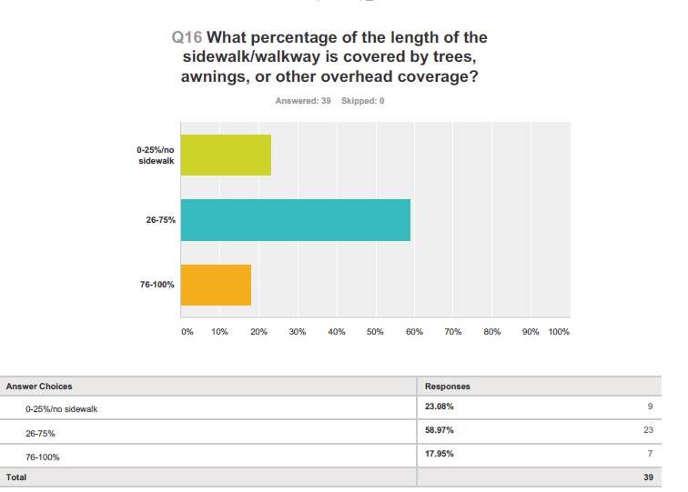
30 Trees, Awnings, Overhangs There are some areas that have tree overgrowth and fence hazards which impact a safe sidewalk commute Some trees are overhanging, impacting electrical lines and blocking stop sign views 31 32
31 Survey Results 33 Pedestrian Walk Signal There are no pedestrian walk signals along the Walkability Assessment streets There are pedestrian walk signals at the intersections of Santa Cruz and Yosemite Blvd. and Empire and Yosemite Blvd. 34


32 Pedestrian Crosswalks At Orville Wright Elementary At Santa Cruz and Oregon Dr. 35 Survey Results 36


33 Ramp at Curbs It appears all corner curbs had ramps However, many of the ramps were in need of maintenance or repair 37 Ramps 38
34 Survey Results 39 Marked Crosswalks Many crosswalks in the community are marked, but not clearly Many, if not all, are in need of repainting Some have major cracks and are unsafe for walking New crosswalks at the corner of Empire and Monterey would increase safety for students walking to and from school 40


35 Crosswalks 41 Observations Beyond the Survey Need more crosswalks for students to get to and from school Need more lighting; need to repair lighting Need flashing lights near school Need crosswalks near major intersections Trees growing into powerlines/need trimming Awareness of dogs/cats Lack of sidewalks in residential area Need stop signs at school intersections 42
36 Questions? Thank You! 43
RECOMMENDATIONS TO IMPROVE PEDESTRIAN & BICYCLIST SAFETY FOR THE MOUNTAIN VIEW SCHOOL DISTRICT (EL MONTE/SOUTH EL MONTE)
") RECOMMENDATIONS TO IMPROVE PEDESTRIAN & BICYCLIST SAFETY FOR THE MOUNTAIN VIEW SCHOOL DISTRICT (EL MONTE/SOUTH EL MONTE) August 2016 By Caro Jauregui, Jaime Fearer, Tony Dang, Wendy Alfsen California Walks;
RECOMMENDATIONS TO IMPROVE PEDESTRIAN & BICYCLIST SAFETY FOR THE MOUNTAIN VIEW SCHOOL DISTRICT (EL MONTE/SOUTH EL MONTE) August 2016 By Caro Jauregui, Jaime Fearer, Tony Dang, Wendy Alfsen California Walks;
RECOMMENDATIONS TO IMPROVE PEDESTRIAN & BICYCLIST SAFETY IN LOS ANGELES CHINATOWN
 RECOMMENDATIONS TO IMPROVE PEDESTRIAN & BICYCLIST SAFETY IN LOS ANGELES CHINATOWN October 2016 By Tony Dang, Caro Jauregui, Jaime Fearer, Wendy Alfsen, California Walks; Jill Cooper, Katherine Chen, UC
RECOMMENDATIONS TO IMPROVE PEDESTRIAN SAFETY IN MCKINLEYVILLE
 RECOMMENDATIONS TO IMPROVE PEDESTRIAN SAFETY IN MCKINLEYVILLE May 2015 By Tony Dang, Jaime Fearer, Wendy Alfsen, California Walks; Jill Cooper, UC Berkeley SafeTREC Recommendations to Improve Pedestrian
RECOMMENDATIONS TO IMPROVE PEDESTRIAN & BICYCLE SAFETY IN THE COMMUNITY OF FLORENCE-FIRESTONE
 RECOMMENDATIONS TO IMPROVE PEDESTRIAN & BICYCLE SAFETY IN THE COMMUNITY OF FLORENCE-FIRESTONE September 2017 By Miha Tomuta, Wendy Ortiz, California Walks; Jill Cooper, Katherine Chen, UC Berkeley SafeTREC
Recommendations to Improve Pedestrian & Bicycle Safety in the Azusa Unified School District
 Recommendations to Improve Pedestrian & Bicycle Safety in the Azusa Unified School District October 2017 Recommendations to Improve Pedestrian & Bicycle Safety in the Azusa Unified School District By Mihaela
Recommendations to Improve Pedestrian & Bicycle Safety for the Missouri Flat Area (El Dorado County)
") Recommendations to Improve Pedestrian & Bicycle Safety for the Missouri Flat Area (El Dorado County) October 2017 Recommendations to Improve Pedestrian & Bicycle Safety for the Missouri Flat Area (El Dorado
Recommendations to Improve Pedestrian & Bicycle Safety for the Missouri Flat Area (El Dorado County) October 2017 Recommendations to Improve Pedestrian & Bicycle Safety for the Missouri Flat Area (El Dorado
Recommendations to Improve Pedestrian & Bicycle Safety for the Community of Palermo
 Recommendations to Improve Pedestrian & Bicycle Safety for the Community of Palermo September 2017 Recommendations to Improve Pedestrian & Bicycle Safety for the Community of Palermo By Wendy Ortiz, Jaime
Recommendations to Improve Pedestrian & Bicycle Safety for the Community of Southwest Fresno
 Recommendations to Improve Pedestrian & Bicycle Safety for the Community of Southwest Fresno October 2017 Recommendations to Improve Pedestrian & Bicycle Safety for the Community of Southwest Fresno By
Recommendations to Improve Pedestrian & Bicycle Safety for the Community of North Shore
 Recommendations to Improve Pedestrian & Bicycle Safety for the Community of North Shore October 2017 Recommendations to Improve Pedestrian & Bicycle Safety for the Community of North Shore By Tony Dang,
RECOMMENDATIONS TO IMPROVE PEDESTRIAN & BICYCLIST SAFETY IN THE CITY OF SHASTA LAKE
 RECOMMENDATIONS TO IMPROVE PEDESTRIAN & BICYCLIST SAFETY IN THE CITY OF SHASTA LAKE October 2016 By Tony Dang, Jaime Fearer, Wendy Alfsen, California Walks; Jill Cooper, Jesus Barajas, UC Berkeley SafeTREC
Chapter 14 PARLIER RELATIONSHIP TO CITY PLANS AND POLICIES. Recommendations to Improve Pedestrian Safety in the City of Parlier (2014)
") Chapter 14 PARLIER This chapter describes the current status and future plans for biking and walking in the City of Parlier. RELATIONSHIP TO CITY PLANS AND POLICIES The Parlier General Plan is the primary
Chapter 14 PARLIER This chapter describes the current status and future plans for biking and walking in the City of Parlier. RELATIONSHIP TO CITY PLANS AND POLICIES The Parlier General Plan is the primary
RECOMMENDATIONS TO IMPROVE PEDESTRIAN & BICYCLE SAFETY IN ROSEMONT
 RECOMMENDATIONS TO IMPROVE PEDESTRIAN & BICYCLE SAFETY IN ROSEMONT SEPT 2017 By Tony Dang, Jaime Fearer, Miha Tomuta, Wendy Ortiz, California Walks; Jill Cooper, Jessica Rosas, UC Berkeley SafeTREC Recommendations
PEDESTRIAN ACTION PLAN
 ATTACHMENT 2 CITY OF SANTA MONICA PEDESTRIAN ACTION PLAN CITY OF SANTA MONICA PEDESTRIAN ACTION PLAN This page intentionally left blank EXECUTIVE SUMMARY CHAPTER 1 EXECUTIVE SUMMARY Setting the Stage
Lee s Summit Road Improvement Study Public Open House June 7, 2007 Summary of Comment Card Responses
 Lee s Summit Road Improvement Study Public Open House June 7, 2007 Summary of Comment Card Responses Introduction At the Lee s Summit Road Improvement Study Public Open House held Thursday, June 7, 2007
o n - m o t o r i z e d transportation is an overlooked element that can greatly enhance the overall quality of life for the community s residents.
 N o n - m o t o r i z e d transportation is an overlooked element that can greatly enhance the overall quality of life for the community s residents. 84 Transportation CHAPTER 11 INTRODUCTION Transportation
Recommendations to Improve Pedestrian & Bicycle Safety for the City of Arvin
 Recommendations to Improve Pedestrian & Bicycle Safety for the City of Arvin July 2018 1 Acknowledgements Planning Committee Jack Becker Tammy Fisher Pat Ebel Peter Smith Carlos Bello Christine Viterelli
2. Vision & Goals. Vision. Santa Rosa is a community where walking and bicycling are comfortable and convenient for people of all ages and abilities.
 2. Vision & Goals Overview The goals of the Santa Rosa Bicycle and Pedestrian Master Plan Update reflect the priorities expressed by the community throughout the public outreach phase of this Plan Update.
Living Streets Policy
 Living Streets Policy Introduction Living streets balance the needs of motorists, bicyclists, pedestrians and transit riders in ways that promote safety and convenience, enhance community identity, create
C/CAG. Sunnybrae Elementary School Walking and Bicycling Audit. San Mateo-Foster City School District JUNE 2013
 Sunnybrae Elementary School Walking and Bicycling Audit JUNE 2013 San Mateo-Foster City School District C/CAG City/County Association of Governments of San Mateo County SUNNYBRAE ELEMENTARY SCHOOL WALKING
Recommendations to Improve Pedestrian & Bicycle Safety for the City of Hayward: Tennyson Road Corridor
 Recommendations to Improve Pedestrian & Bicycle Safety for the City of Hayward: Tennyson Road Corridor October 2018 1 Acknowledgments Planning Committee Charmine Solla Steven Chang Patty Garcia Sergio
7/23/2017 VIA . Michael Hanebutt City of Sacramento Community Development Department 300 Richards Boulevard, 3 rd Floor Sacramento, CA 95811
 7/23/2017 VIA EMAIL Michael Hanebutt City of Sacramento Community Development Department 300 Richards Boulevard, 3 rd Floor Sacramento, CA 95811 RE: 65 th Street Apartments (DR17-220) Dear Mr. Hanebutt:
Recommendations to Improve Pedestrian & Bicycle Safety for the Arden-Arcade Community
 Recommendations to Improve Pedestrian & Bicycle Safety for the Arden-Arcade Community June 2018 Acknowledgements Planning Committee Joelle Orrock Gail Kelly Molly Patterson Dan Allison Heather Yee Molly
Recommendations to Improve Pedestrian & Bicycle Safety for the City of Bakersfield
 Recommendations to Improve Pedestrian & Bicycle Safety for the City of Bakersfield August 2018 1 Acknowledgements Planning Committee Jack Becker Bike Bakersfield Cindy Parra Bike Bakersfield Christopher
COMMUNITY PEDESTRAIN SAFETY TRAINING. Long Beach June 5 th, 2010
 COMMUNITY PEDESTRAIN SAFETY TRAINING Long Beach June 5 th, 2010 Long Beach The City of Long Beach is located in Los Angeles County, Southern California. Long Beach is currently home to 462,604 persons
RECOMMENDATIONS TO IMPROVE PEDESTRIAN SAFETY IN THE TOWN OF PARADISE
 RECOMMENDATIONS TO IMPROVE PEDESTRIAN SAFETY IN THE TOWN OF PARADISE September 2013 By Tony Dang, Wendy Alfsen, California WALKS This report is funded by the UC Berkeley Safe Transportation Research and
MASTER BICYCLE AND PEDESTRIAN PLAN
 VILLAGE OF NORTHBROOK MASTER BICYCLE AND PEDESTRIAN PLAN DRAFT PLAN OPEN HOUSE May 2, 2018 AGENDA 1. Community Engagement 2. Vision and Goals 3. General Structure of Plan 4. Recommendations Overview 5.
Recommendations to Improve Pedestrian & Bicycle Safety for the Clegg Elementary School & Stacey Middle School Community
 Recommendations to Improve Pedestrian & Bicycle Safety for the Clegg Elementary School & Stacey Middle School Community (Westminster School District) October 2018 1 Acknowledgements Planning Committee
PRESS RELEASE San Joaquin Council of Governments
 PRESS RELEASE San Joaquin Council of Governments For Immediate Release February 23, 2018 Contact: Nicole Gorham, 235-0582 gorham@sjcog.org SJCOG Board Awards $19.63 Million in Measure K Bicycle, Pedestrian,
City of San Diego Vision Zero Draft Strategic Plan FY 2017
 City of San Diego Vision Zero Draft Strategic Plan FY 2017 Engineering Objective: To develop and implement a strategy that employs best planning, design and engineering practices. Background: Over the
Appendix C 3. Bicycle / Pedestrian Planning
 Appendix C 3. Bicycle / Pedestrian Planning BICYCLE/PEDESTRIAN PLANNING 2005 Master Plan GOAL: Provide for safe and convenient bicycle and pedestrian circulation throughout the City. Develop a city-wide
Monument Elementary School Trenton, NJ School Travel Plan
 Monument Elementary School Trenton, NJ School Travel Plan Prepared by Greater Mercer TMA With Assistance from Alan M. Voorhees Transportation Center; Rutgers, The State University of New Jersey and NJ
APPENDIX A: Complete Streets Checklist DRAFT NOVEMBER 2016
 APPENDIX A: Complete Streets Checklist DRAFT NOVEMBER 2016 Complete Streets Checklist MetroPlan Orlando s Complete Streets Checklist is an internal planning tool for staff to further implementation of
City of Wilsonville 5 th Street to Kinsman Road Extension Project
 City of Wilsonville 5 th Street to Kinsman Road Walking Tour & Neighborhood Workshop Summary Report Public Outreach Overview On July 18 th, 2017, the City of Wilsonville hosted a neighborhood walking tour
TABLE OF CONTENTS. Executive Summary
 Executive Summary Background... ES-1 Pedestrian Network... ES-2 Bikeway Network... ES-2 Collision History... ES-2 Public Input... ES-4 Conclusions and Recommendations... ES-4 1. Introduction and Setting
Clay Street Bridge Replacement Project
 Clay Street Bridge Replacement Project Frequently Asked Questions (FAQs) The project is located in downtown Placerville on Clay Street between US Highway 50 and Main Street and Cedar Ravine Road. The proposed
FEDERAL HIGHWAY ADMINISTRATION APPLICATION
 FEDERAL HIGHWAY ADMINISTRATION APPLICATION REQUEST FOR PERMISSION TO EXPERIMENT WITH A BICYCLE BOX INTERSECTION TREATMENT Submitted by: City of Columbus Department of Public Service Date: June 26, 2009
City of Novi Non-Motorized Master Plan 2011 Executive Summary
 City of Novi Non-Motorized Master Plan 2011 Executive Summary Prepared by: February 28, 2011 Why Plan? Encouraging healthy, active lifestyles through pathway and sidewalk connectivity has been a focus
SAFE ROUTES TO SCHOOL (SR2S)
") SAFE ROUTES TO SCHOOL (SR2S) In partnership with Burbank Unified School District (BUSD) & City of Burbank George Washington Elementary School Thomas Jefferson Elementary School John Muir Middle School
SAFE ROUTES TO SCHOOL (SR2S) In partnership with Burbank Unified School District (BUSD) & City of Burbank George Washington Elementary School Thomas Jefferson Elementary School John Muir Middle School
5. Pedestrian System. Accomplishments Over the Past Five Years
 5. Pedestrian System Accomplishments Over the Past Five Years The Alamo Area Metropolitan Planning Organization (MPO) and its partner agencies recognize the importance of improving pedestrian mobility.
July 5, Arthur R. Ware, Jr. Elementary School 2017 Safe Routes to School Walkabout Report
 July 5, 2017 Arthur R. Ware, Jr. Elementary School 2017 Safe Routes to School Walkabout Report 1 Walkabout Report Introduction On April 28, 2017, City, School, and SAWMPO staff met to conduct a Safe Routes
Safe Routes to School Guide
 Safe Routes to School Guide Steps to Creating a Safe Routes to School Program Created February 2007 SafeRoutes National Center for Safe Routes to School This guide was developed by the Pedestrian and Bicycle
Tonight is for you. Learn everything you can. Share all your ideas.
 Strathcona Neighbourhood Renewal Draft Concept Design Tonight is for you. Learn everything you can. Share all your ideas. What is Neighbourhood Renewal? Creating a design with you for your neighbourhood.
CONNECTIVITY PLAN. Adopted December 5, 2017 City of Virginia Beach
 CONNECTIVITY PLAN Adopted December 5, 2017 City of Virginia Beach CONTENTS 1.0 Background & Purpose... 2 2.0 Existing Inventory & Analysis... 3 ViBe District Existing Walking Conditions... 4 3.0 ViBe District
Hedgepeth Williams Middle School and Paul Robeson Elementary School Trenton, NJ. School Travel Plan
 Hedgepeth Williams Middle School and Paul Robeson Elementary School Trenton, NJ School Travel Plan Hedgepeth Williams Middle School Description: Hedgepeth-Williams Middle School is located at 301 Gladstone
Pinellas County Safety Initiatives
 Florida Department of TRANSPORTATION Pinellas County Safety Initiatives Whit Blanton, FAICP Pinellas County MPO A Distinctive County A unique geography Multi-jurisdictional Key demographics seniors and
Corpus Christi Metropolitan Transportation Plan Fiscal Year Introduction:
 Introduction: The Safe, Accountable, Flexible, Efficient Transportation Equity Act: A Legacy for Users (SAFETEA-LU) has continued the efforts started through the Intermodal Surface Transportation Efficiency
8/31/2016 VIA . RE: Freeport Arco Fuel Station (P16-039)
") 8/31/2016 VIA EMAIL Garrett Norman, Assistant Planner City of Sacramento Community Development Department 300 Richards Boulevard, 3 rd Floor Sacramento, CA 95811 RE: Freeport Arco Fuel Station (P16-039)
8/31/2016 VIA EMAIL Garrett Norman, Assistant Planner City of Sacramento Community Development Department 300 Richards Boulevard, 3 rd Floor Sacramento, CA 95811 RE: Freeport Arco Fuel Station (P16-039)
IMPLEMENTATION STRATEGIES
 GEORGETOWN SIDEWALK MASTER PLAN 34% of funding is dedicated to Downtown Overlay District sidewalks 28% of funding is recommended within 1/4 mile of Southwestern University 26% of funding is recommended
ACTIVE TRANSPORTATION/NONMOTORIZED TRANSPORTATION
 ACTIVE TRANSPORTATION/NONMOTORIZED TRANSPORTATION BACKGROUND Active transportation, also known as nonmotorized transportation, is increasingly recognized as an important consideration when planning and
Recommendations to Improve Pedestrian & Bicycle Safety for the Zane Middle School Community
 Recommendations to Improve Pedestrian & Bicycle Safety for the Zane Middle School Community October 2018 1 Acknowledgements Planning Committee Nicole Sager Jesse Willor Jenny Weiss Emily Sinkhorn Scott
TRAFFIC ACTION PLAN. Laurie Meadows Neighborhood CITY OF SAN MATEO
 TRAFFIC ACTION PLAN Laurie Meadows Neighborhood CITY OF SAN MATEO Draft January 2017 Table of Contents Introduction... 2 The Traffic Forum Process... 5 Neighborhood Traffic Issues... 7 Neighborhood Recommendations
Bicycle Master Plan Goals, Strategies, and Policies
 Bicycle Master Plan Goals, Strategies, and Policies Mobilizing 5 This chapter outlines the overarching goals, action statements, and action items Long Beach will take in order to achieve its vision of
CITY MANUALS AND STANDARDS REVIEW
 GEORGETOWN SIDEWALK MASTER PLAN CITY MANUALS AND STANDARDS REVIEW RESOURCES AND STANDARDS As part of the Master Plan process, a review and evaluation of current City documents and policies relevant to
WALKABILITY CHECKLIST How walkable is your community?
 WALKABILITY CHECKLIST How walkable is your community? Everyone benefits from walking and other forms of active transportation. These benefits include: improved fitness, cleaner air, reduced risks of certain
WALKNBIKE DRAFT PLAN NASHVILLE, TENNESSEE EXECUTIVE SUMMARY NASHVILLE, TENNESSEE
 NASHVILLE, TENNESSEE EXECUTIVE SUMMARY Executive Summary A world-class multi-modal transportation system is essential to a vibrant city and better quality of life. -Mayor Barry The WalknBike plan aims
Improvements Infrastructure Gap Assessment and Improvements Street Striping
 Infrastructure Project Proposal The federal-aid Safe Routes to School program funds infrastructure/engineering projects that fall into two categories: Design (available only to School Development Authority
Welcome! San Jose Avenue Open House August 25, 2015
 Welcome! San Jose Avenue Open House August 25, 2015 Vision Zero The City and County of San Francisco adopted Vision Zero San Francisco Vision Zero High Injury Network as a policy in 2014, committing an
COMMUNITY PEDESTRAIN SAFETY TRAINING. Santa Ana June 27 th 2009
 COMMUNITY PEDESTRAIN SAFETY TRAINING Santa Ana June 27 th 2009 Santa Ana Santa Ana is the heart of Orange County located in Southern California. The estimated population of Santa Ana is 339,130 in 2008,
Non-Motorized Transportation 7-1
 Non-Motorized Transportation 7-1 Transportation facilities no longer mean just accommodating a vehicle powered by a combustion engine. Pedestrian and non-motorized facilities are important modes of travel
Fill in the rating for each section. Total up the ratings to see how your neighbourhood scores overall for walkability.
 WALKABILITY CHECKLIST How walkable is your community? Everyone benefits from walking and other forms of active transportation. These benefits include: improved fitness, cleaner air, reduced risks of certain
Ocean Park Boulevard Green Street Project Community Workshop
 Ocean Park Boulevard Green Street Project Community Workshop 2.2.10 Project Objectives Community Priority: reclaim OPB for public open space. Build upon LUCE principles; neighborhood enhancement, connectivity,
Safe Routes to School: Munroe Elementary Walk Audit Report. Image: Drexel, Barrell & Co.
 Safe Routes to School: Munroe Elementary Walk Audit Report Image: Drexel, Barrell & Co. April 12, 2016 OVERVIEW As part of the 2014/2015 Denver Safe Routes to School (SRTS) Program, WalkDenver coordinated
Pedestrian, Bicycle and Traffic Calming Strategic Implementation Plan. January 18, 2011
 Pedestrian, Bicycle and Traffic Calming Strategic Implementation Plan January 18, 2011 Tonight s Agenda Receive update on project Provide feedback on two policy issues Complete Streets Policy Project Prioritization
CHAPTER 3: Vision Statement and Goals
 Davidson Walks & Rolls: Active Transportation Master Plan CHAPTER 3 Contents: Overview Vision Statement Measurable Goals Public Outreach CHAPTER 3: Vision Statement and Goals Overview The vision statement
Tri-State Transportation Campaign Greater Newark Conservancy Newark Complete Streets Walking Audit July 2013
 Tri-State Transportation Campaign Greater Newark Conservancy Newark Complete Streets Walking Audit July 2013 On July 22, 2013, TSTC teamed up with 40 high school student interns and their mentors from
CONNECTING PEOPLE TO PLACES
 CONNECTING PEOPLE TO PLACES 82 EAST BENCH MASTER PLAN 07 Introduction The East Bench transportation system is a collection of slow moving, treelined residential streets and major arteries that are the
Commerce Street Complete Street Project from Good Latimer Expressway to Exposition Avenue
 Commerce Street Complete Street Project from Good Latimer Expressway to Exposition Avenue T A N Y A B R O O K S A S S I S T A N T D I R E C T O R M O B I L I T Y P L A N N I N G M O B I L I T Y A N D S
City of Davis East Covell Corridor Plan
 Community Open House #2 January 22, 2014 6:00 8:00 p.m. Veterans Memorial Center, Club Room City of Davis Introduction The (ECCP) is a taking a comprehensive look at the existing transportation systems
City of Birmingham Draft Multi-modal Transportation Plan
 City of Birmingham Draft Multi-modal Transportation Plan City Commission Public Hearing Monday, November 25, 2013 7:30 pm Norman Cox, PLA, ASLA The Greenway Collaborative, Inc. Ann Arbor, Michigan The
Appendix T CCMP TRAIL TRAFFIC & TRANSPORTATION DESIGN STANDARD
 Appendix T CCMP 3.3.4 TRAIL TRAFFIC & TRANSPORTATION DESIGN STANDARD 3.3.4 Trail Traffic and Transportation Design Multi-use trails have certain design standards, which vary depending on the agency that
AGENDA ITEM NO. 5b HCAOG TAC meeting of May 8, 2014
 Humboldt County Association of Governments Eureka, CA, 95501 AGENDA ITEM NO. 5b HCAOG TAC meeting of May 8, 2014 DATE: May 1, 2014 TO: HCAOG Technical Advisory Committee (TAC) FROM:, SUBJECT: Letters of
Chapter 2: Standards for Access, Non-Motorized, and Transit
 Standards for Access, Non-Motorized, and Transit Chapter 2: Standards for Access, Non-Motorized, and Transit The Washtenaw County Access Management Plan was developed based on the analysis of existing
Agenda. Overview PRINCE GEORGE S PLAZA METRO AREA PEDESTRIAN PLAN
 PRINCE GEORGE S PLAZA METRO AREA PEDESTRIAN PLAN May 28, 2008 Agenda Welcome and introductions Project overview and issue identification Planning context and strengths Design challenges and initial recommendations
CITY OF COCOA BEACH 2025 COMPREHENSIVE PLAN. Section VIII Mobility Element Goals, Objectives, and Policies
 CITY OF COCOA BEACH 2025 COMPREHENSIVE PLAN Section VIII Mobility Element Goals, Objectives, and Policies Adopted August 6, 2015 by Ordinance No. 1591 VIII MOBILITY ELEMENT Table of Contents Page Number
Bringing together community and health. Physical Activity and Nutrition Unit Office of Statewide Health Improvement Initiatives
 Bringing together community and health. Physical Activity and Nutrition Unit Office of Statewide Health Improvement Initiatives Physical Activity and Nutrition Unit Office of Statewide Health Improvement
ACTIVE TRANSPORTATION
 ACTIVE TRANSPORTATION Mobility 2040 Supported Goals Improve the availability of transportation options for people and goods. Support travel efficiency measures and system enhancements targeted at congestion
City of Ann Arbor Pedestrian Safety & Access Task Force
 City of Ann Arbor Pedestrian Safety & Access Task Force Community Wide Meeting #2 Wednesday, March 25 th 6:30 to 8:30 PM Multi-purpose Room, Downtown Library The Greenway Collaborative, Inc. www.greenwaycollab.com
Safe Routes to School Action Plan Aberdeen, Idaho
 Background Aberdeen, Idaho is a largely agricultural community of nearly 2,000 people and is located in the southeast portion of the state on the western edge of American Falls Reservoir. The community
Proposed. City of Grand Junction Complete Streets Policy. Exhibit 10
 Proposed City of Grand Junction Complete Streets Policy Exhibit 10 1 City of Grand Junction Complete Streets Policy Vision: The Complete Streets Vision is to develop a safe, efficient, and reliable travel
Oakland Pedestrian Master Plan Oakland Pedestrian Plan Draft Recommendations Chapter Outline
 EISEN LETUNIC T R A N S P O R T A T I O N, ENVIRO N M E N TA L A N D URBAN PLANNIN G MEMORANDUM To Oakland Pedestrian Plan Technical Advisory Committee & Pedestrian Advisory Group From Victoria Eisen Date
Circulation in Elk Grove includes: Motor vehicles, including cars and trucks
 Circulation, as it is used in this General Plan, refers to the many ways people and goods move from place to place in Elk Grove and the region. Circulation in Elk Grove includes: Motor vehicles, including
5/7/2013 VIA . RE: University Village Safeway Expansion (P13-019)
") 5/7/2013 VIA EMAIL David Hung, Associate Planner Community Development Department, Current Planning Division City of Sacramento 300 Richards Boulevard, 3 rd Floor Sacramento, CA 95811 RE: University Village
5/7/2013 VIA EMAIL David Hung, Associate Planner Community Development Department, Current Planning Division City of Sacramento 300 Richards Boulevard, 3 rd Floor Sacramento, CA 95811 RE: University Village
Microscale Audit of Pedestrian Streetscapes (MAPS), Mini Version
, Mini Version") Microscale Audit of Pedestrian Streetscapes (MAPS), Mini Version Training Manual & Picture Guide Developed by: Carrie Geremia Kelli Cain Revised February 11, 2014 Tool and protocol developed by: James
Microscale Audit of Pedestrian Streetscapes (MAPS), Mini Version Training Manual & Picture Guide Developed by: Carrie Geremia Kelli Cain Revised February 11, 2014 Tool and protocol developed by: James
FLORIDA DEPARTMENT OF TRANSPORTATION DISTRICT 7 DISTRICT WIDE BICYCLE/PEDESTRIAN ACCESS TO TRANSIT SAFETY ASSESSMENT AND IMPROVEMENT PLAN
 FLORIDA DEPARTMENT OF TRANSPORTATION DISTRICT 7 DISTRICT WIDE BICYCLE/PEDESTRIAN ACCESS TO TRANSIT SAFETY ASSESSMENT AND IMPROVEMENT PLAN TRANSIT SAFETY ASSESSMENT SR 55/US 19 AT 80 TH AVE N DRAFT JUNE
Caltrans Sloat Boulevard Pedestrian Safety Project Response to Community Questions, Comments & Concerns
 Caltrans Sloat Boulevard Pedestrian Safety Project Response to Community Questions, Comments & Concerns Revised: May 10, 2016 The California Department of Transportation (Caltrans) is planning various
Solana Beach Comprehensive Active Transportation Strategy (CATS)
") Solana Beach Comprehensive Active Transportation Strategy (CATS) 3.0 Goals & Policies The Solana Beach CATS goals and objectives outlined below were largely drawn from the Solana Beach Circulation Element
Solana Beach Comprehensive Active Transportation Strategy (CATS) 3.0 Goals & Policies The Solana Beach CATS goals and objectives outlined below were largely drawn from the Solana Beach Circulation Element
12/4/2016 VIA . RE: Grocery Outlet Del Paso (DR16-328)
") 12/4/2016 VIA EMAIL Ethan Meltzer, Assistant Planner City of Sacramento Community Development Department 300 Richards Blvd, 3 rd Floor Sacramento, CA 95811 RE: Grocery Outlet Del Paso (DR16-328) Dear Mr.
12/4/2016 VIA EMAIL Ethan Meltzer, Assistant Planner City of Sacramento Community Development Department 300 Richards Blvd, 3 rd Floor Sacramento, CA 95811 RE: Grocery Outlet Del Paso (DR16-328) Dear Mr.
SAFE ROUTES TO SCHOOL
 SAFE ROUTES TO SCHOOL Forest Ridge Elementary School Existing Conditions and ACTION PLAN > Oak Creek - Franklin Joint School District Table of Contents CONTEXT Enrollment Boundaries
City of Jacksonville Mobility Fee Update
 City of Jacksonville Mobility Fee Update 2017 Preliminary Analysis May 3, 2017 Carnival Cruise lines photo credit Presentation Overview Public Outreach Process Pedestrian and Bicycle Master Plan Study
David Hung, Associate Planner City of Sacramento Community Development Department 300 Richards Boulevard, 3 rd Floor Sacramento, CA
 June 13, 2016 VIA EMAIL David Hung, Associate Planner City of Sacramento Community Development Department 300 Richards Boulevard, 3 rd Floor Sacramento, CA 959811 RE: Fire Station 14 (DR16-128) Dear Mr.
Sistrunk Corridor DOTMOCRACY SUMMARY
 DOTMOCRACY SUMMARY The TOUCH initiative is a true collaborative working with multi- sector community organizations and agencies to reduce tobacco use and exposure to secondhand smoke, improve access to
AGENDA ITEM SUMMARY SPECIAL AGENDA ITEM NO. _1A_
 AGENDA ITEM SUMMARY AGENCY: City Council MEETING DATE: June 25, 2012 DEPARTMENT: Community Dev PREPARED BY: T Spade DEPT. DIR. APPROVAL: MJ CITY MGR. APPROVAL: LR PRESENTED BY: T Spade TITLE: RECEIVE REPORT
Recommendations to Improve Pedestrian & Bicycle Safety for the Valley West Community in Arcata
 Recommendations to Improve Pedestrian & Bicycle Safety for the Valley West Community in Arcata October 2018 1 Acknowledgements Planning Committee Netra Khatri Julie Neander Emily Sinkhorn Jennifer Weiss
This page intentionally left blank.
 This page intentionally left blank. COMMUNITY Coweta Community Overview Coweta Coweta, a residential community located in Wagoner County, is a suburb of Tulsa situated southeast of the metropolitan area
NM-POLICY 1: Improve service levels, participation, and options for non-motorized transportation modes throughout the County.
 Transportation PRINCE WILLIAM COUNTY 2008 COMPREHENSIVE PLAN NON-MOTORIZED PLAN CONTENTS Goals, Policies, and Action Strategies Table 4 (Bike Facility Classifications and Descriptions) Table 5 (Bike Facility
COMMUNITY PARTICIPATION CHAPTER 8
 COMMUNITY PARTICIPATION CHAPTER 8 8.1 ROLE OF THE CITY S BICYCLE ADVISORY COMMISION 8.2 BICYCLE TRANSPORTATION PLAN STAKEHOLDERS 8.2.1 Stakeholders 8.2.2 Stakeholders Letters of Recommendations 8.3 CITY
DRAFT. Lecompton. Table of Contents. Background
 Lecompton Table of Contents Existing Infrastructure 98 Funding 100 Policy and Program Recommendations 102 Infrastructure Recommendations 104 Conclusion 109 Douglas County Lecompton Background Located at
TRAFFIC ACTION PLAN. North Central Neighborhood CITY OF SAN MATEO
 TRAFFIC ACTION PLAN North Central Neighborhood CITY OF SAN MATEO Draft February 2017 Table of Contents Introduction... 1 The Traffic Forum Process... 4 Neighborhood Traffic Issues... 6 Neighborhood Recommendations
Bikeway action plan. Bicycle Friendly Community Workshop March 5, 2007 Rochester, MN
 Bikeway action plan Summary The was held on March 5, 2007 at the Rochester Mayo Civic Center. The workshop was hosted by Rochester-Olmsted County Planning Department in collaboration with the League of
DRAFT. Table of Contents. Background
 Douglas County Table of Contents Existing Infrastructure 86 Funding 89 Policy and Program Recommendations 90 Infrastructure Recommendations 92 Conclusion 95 Background Home to 4,500 residents and Baker