A collaboration between St. Mary School, Chardon Local Schools, and the City of Chardon 1/22/10
|
|
|
- Nickolas Hawkins
- 5 years ago
- Views:
Transcription
1 A collaboration between St. Mary School, Chardon Local Schools, and the City of Chardon 1/22/10
2 SECTION 1: THE SAFE ROUTES TO SCHOOL TEAM Identified stakeholders for Safe Routes to School (SRTS) include the City of Chardon, Chardon Local School District, St. Mary School, parents, and City residents. The schools targeted by this study include Maple Elementary, Park Elementary, Chardon Middle School, which are in the Chardon Local School District; and St. Mary School, a parochial school that serves Chardon and surrounding areas. The Primary Contact for SRTS is: Randy Sharpe, Assistant City Manager City of Chardon 111 Water Street Chardon, Ohio (440) Other representatives from the City include: Dave Lelko, City Manager Joe Rodriguez, Parks and Recreation Director Doug Courtney, City Engineer Tim McKenna, Police Chief Pat Janouskouec, Parking Enforcement Officer They can be contacted at: City of Chardon 111 Water Street Chardon, Ohio Telephone Representatives from the Chardon Local School District include: Joseph Bergant, Superintendent Dana Stearns, Director of Operations Ellen Ondrey, Communications Director Kathleen Sawyer, Principal, Maple Elementary School Rhonda Garrett, Principal, Park Elementary School They can be contacted at: Chardon Local School District 428 North Street Chardon, Ohio Telephone Chardon Schools Safe Routes to School Walk and Roll 1
3 Representatives from St. Mary School include: Sr. Sandy Nativio, Principal She can be contacted at: St. Mary School 401 North Street Chardon, Ohio Telephone Representatives for Parents and City residents include: Cindy and Tom Nolfi Mary Jo Stark Debbie Horton Eric Stropkay Laura Novotney Amy Cohn Cathy Gillette SECTION 2: INTRODUCTION The stakeholders chose the name Walk and Roll as a catchy phrase to create interest at the student level in promoting walking and biking to and from school. Within the past few years the City has completed several studies which determined the need for improvements relative to walking and biking within the community. These studies included: Revising its Comprehensive Plan in March 2008, and recognizing the importance of being pedestrian friendly and providing linkages throughout the City. An extension of the Comprehensive plan includes receiving a NOACA - TLCI (Transportation for Livable Communities Initiative) grant for funding the City of Chardon-Bicycle and Pedestrian Plan, which will establish priority locations and alignment for bicycle and pedestrian linkages and connections within the City. The next phase of this grant is to work with Chardon Local Schools to initiate a safe routes to school program. Completing a National Center for Bikeable and Walkable Communities workshop in 2006 which provided education, encouragement, and a walking audit to identify challenges and possible solutions. The Geauga Park District has an interest in seeing the community improve its walking and biking connections as well. They recently completed portions of the Maple Highlands Trail, a multipurpose trail connecting to points north and south of the City. Chardon Schools Safe Routes to School Walk and Roll 2
4 This trail provides an opportunity for the City to create a multi-modal pathway to connect the north and south trailheads. The school district and St. Mary School also identified problem areas relating to traffic and the overall safety of their students. The District Communications Director for Chardon Local Schools, as part of the SRTS committee, solicited input and support from various school district stakeholders, including the Superintendent, Director of Operations, Food Service Director, Building Principals, PTO Leaders, Nurses, and the Physical Education Department Heads. All have weighed in on what they see as the need to increase the awareness among parents and students about childhood obesity, and how to promote healthy lifestyles. In a presentation to the Chardon Board of Education in the spring of 2008, the Head of Chardon s Physical Education Department reported that if child obesity rates continue upward, the current generation of students will be the first who will not outlive their parents. Both the district nurses and PE teachers provided information showing how the SRTS program complements the district s mission and enhances the work they are already doing with students to promote healthy lifestyles. In addition, due to the ever increasing traffic congestion around the schools, the district needs to promote environmentally responsible driving practices. These interests and concerns in turn led to applying for Safe Routes to School funding in order to help alleviate problems and provide linkages and connections within the City. A brainstorming session was held at the first community meeting on June 26, Many issues were identified at that time and include: dropping off of students in unsafe areas, poor weather conditions, getting from the public sidewalks to the buildings safely, unsafe intersections for student crossings, morning darkness due to early school start, poor visibility, lack of flashing school signal lights, speed limits too high, sidewalk disconnects, and the lack of school promotion for walking. It is the intent of the stakeholders to identify each problem, create a solution, implement the changes, create a strong partnership with the community and schools, and continue to educate students and residents of the community. SCHOOL GOALS Chardon Local Schools Chardon Local Schools Strategic Plan 2007 to 2012 identifies safety, transportation, and education as goals. The mission of the Chardon Local School District is to educate all students to become responsible citizens equipped with the skills necessary for success in an ever-changing, highly diverse, technological world through a committed partnership with students, staff, parents and community. Relative to SRTS, the plan emphasizes curriculum, community involvement/partnerships, and safety/security for students. The plan pro-actively involves the community, ensures communication and results in productive partnerships. Chardon Schools Safe Routes to School Walk and Roll 3
5 St. Mary School The purpose of the St. Mary Strategic Planning Committee is to take an expansive view of the issues facing the parish school and its needs and to address them through various initiatives and planning processes. The committee is to serve as one of the drivers of the process to continuously improve the school and as the identifier of anticipated major changes that might impact the school s viability. Some of the committee s projects include conducting parent and teacher climate surveys for surface issues and concerns, ongoing marketing of the school, and marketing the school by the use of a website and creation of a brochure. SECTION 3: PUBLIC INPUT PROCESS The SRTS Taskforce recognized that obtaining public input is critical to providing safe routes to school for our children. The stakeholders identified walkable needs within the schools, throughout the community at large and for local government. The goals of creating a more livable community, by improving bicycling and walking in our area, creates a strong partnership of cooperation between our students, residents, businesses, and city government. In an effort to obtain critical information regarding barriers and obstacles for walking and bicycling to and from the two grade k 5 elementary schools, one grade k 8 school, and the one grade 6 8 middle school, a variety of processes was utilized. TYPES OF PUBLIC INPUT Kick-off meetings with the stakeholders were held on June 17, 2008 and June 26, A sub-committee was then formed which consisted of some stakeholders, school parents, and Chardon residents. The sub-committee met three times over the summer on June 30, 2008, July 23, 2008, and August 12, 2008, and continued to meet during the school year, on September 10, 2008 and September 30, The sub-committee worked on data collection and completed the first six sections of the School Travel Plan. The SRTS committee obtained information the following ways: Chardon Local Schools and Saint Mary School committee members performed the following tasks: Hosting initial kick off meetings with the stakeholders, and follow-up monthly meetings with the sub-committee as public input gathering sessions. Collecting school demographics data on all involved schools for walking and cycling statistics. Soliciting student opinions via the Parent Teachers Organization (PTO), Principals, Teachers, and the National Junior Honor Society. Planning for school-wide participation in the International Walk to School Day on October 8, Chardon Schools Safe Routes to School Walk and Roll 4
6 Administering parental surveys for attitudes and opinions on walkability issues, safety on school routes, and fitness education. Interviewing key individuals in the schools, community and city for insight on student travel patterns. Utilizing website to obtain public comment and involvement. Suggesting school fitness and wellness objectives of exercise and nutrition be incorporated in physical education instruction. Advertising SRTS Taskforce in school and community publications. Discussing SRTS at PTO meetings. The District Communications Director and the Assistant City Manager presented the status of the plan to the Board and Community at the September 2008 Chardon School Board Meeting The community committee members performed the following tasks: Hosting a workshop to gather input from community by introducing school, city and law enforcement officials to the SRTS goals. Creating walk and roll logo for project marketing in the community. Local government committee members performed the following tasks: The Geauga County Auditor s Office is providing basic geographical data maps identifying one and two mile radius points from each school to focus on the safest routes for walking and cycling to each school. The public is able to comment through the internet by links established on the City of Chardon website The plan was discussed at two City council meetings over the summer. Chardon Schools Safe Routes to School Walk and Roll 5

7 SCHOOL WELLNESS PLANS Chardon Local Schools The Chardon Local School District is committed to establishing a healthy learning environment that positively influences students' general well-being, eating behaviors, physical capacity and learning ability to succeed academically. This commitment provides all of Chardon's students with the ability to participate fully in the educational process and to develop life-long healthy habits. This includes providing a healthy physical and psychological environment, school nurse services, nutritious school meals, health education, and opportunities for physical education and activity. By facilitating learning through the support and promotion of good nutrition and physical activity, student achievement is enhanced. Improved health optimizes student performance potential and ensures that all children have the opportunity to excel. It is the intent of this policy to enable students to become independent and self-directed learners by taking initiative to meet their own health and nutritional needs as is developmentally and individually appropriate. [Adoption date: August 14, 2006] [Readoption date: October 8, 2007]. Park and Maple Elementary schools offer several opportunities to encourage fitness and wellness for students. Some activities include: Footlights, an after school jump rope club. Maple Family Challenge Night, families come and work on a specific group of physical skills together. Chardon Schools Safe Routes to School Walk and Roll 6
8 St. Mary School Trek to Tanzania, a program designed to encourage kids to be aerobically active during recess. Fit as a Pro, a program to encourage activities outside of school and healthy eating habits. Coleman s challenge challenges students to perform 60 to 120 minutes of activities and earn a highpoint for each of the fifty states. This year a committee of students is developing a fitness program where students will perform a number of steps (logged on a pedometer) each morning before school begins. A walking route around the school will be established to help encourage activity during the day. The goals of the school s health plan include recognizing that life and physical health are precious gifts and people must take care of them by making choices related to health based on the value of life and human dignity, valuing personal and group mental, physical, social, emotional, and spiritual growth, implementing critical and creative thinking skills in making daily choices that affect one s health, promoting healthful habits for the purpose of enhancing the quality of life, developing appropriate social behaviors and responsibility by working independently and with others during planned activity; developing the knowledge, skills, and values related to nutrition, growth and development, disease prevention and control, safety and first aid, health issues and dangerous substances, and social and emotional health; integrating the seven themes of catholic social justice teachings, and developing an understanding of the rights of children and how these can be lived out. The goals of St. Mary School s physical education plan, in addition to the above listed goals, include promoting physical fitness for the purpose of enhancing the quality of life; increasing lifetime and leisure sports abilities through movement activities, and adhering to safety procedures. SECTION 4: SCOPE DISTRICT SCHOOL TRAVEL PLAN This study includes Maple Elementary, Park Elementary, Chardon Middle School and St. Mary School. Park Elementary School is located in the heart of downtown Chardon at 111 Goodrich Court and has a total enrollment of 328 students in grades K 5. Maple Elementary School is located at 308 Maple Ave., approximately one mile north of downtown Chardon. It is across Maple Ave. from the high school complex that serves all of Chardon. It has a total enrollment of 263 students in grades K - 5. Chardon Middle School is located at 424 North Street and is west of the high school. It is the only middle school and has a total enrollment of 741 students in grades 6 8. St. Mary School is located at 401 North Street, directly across the street from Chardon Middle School and serves as a parochial school to Chardon residents as well as students from outside the community. It has a total enrollment of 295 students in grades K - 8. Chardon Schools Safe Routes to School Walk and Roll 7
9 Chardon Local Schools bus all their students outside of a one mile radius. Those students within the one mile radius must walk or be dropped off by parents. Students within two miles have the option to ride bicycles. Those students attending St. Mary School and residing outside of the one mile radius in the Chardon Local School system are bused. Students attending St. Mary School and residing outside of the City of Chardon, within the Ledgemont, Cardinal, and Berkshire Local School Districts are also bused to St. Mary School. Students within the two mile radius of St. Mary School have the option to ride bicycles as well. Chardon Schools Safe Routes to School Walk and Roll 8


10 East Park St. Maple Ave. North St. Location Map for Maple Elementary, Chardon Middle School, Chardon High School, and St. Mary School. Middle School High School Maple School St. Mary School Chardon Location Map for Park Elementary Short Court SStt.. Park Auditorium Goodrich Court Park School Chardon Library Chardon Schools Safe Routes to School Walk and Roll 9
11 SECTION 5: SCHOOL DEMOGRAPHICS Demographic information for each school is shown in the following table. information is current school year The Demographic Maple Elementary Park Elementary Chardon Middle St. Mary Caucasian 97.00% 94.30% 97.80% 96.0% African American 1.10% 0.90% 0.90% 0.0% Hispanic 0.00% 0.90% 0.50% 4.0% Asian 1.50% 0.90% 0.30% 0.3% Native American 0.00% 0.00% 0.10% 0% Multi-racial 0.40% 3.00% 0.40% 0% Low Income 39 students 64 students 98 students 7 students Limited English Special Education 44 students 43 students 89 students 14 students Total Enrollment 263 students 328 students 741 students 295 students SECTION 6: CURRENT SCHOOL TRAVEL ENVIRONMENT Student arrival/departure tallies were performed by the teachers of each classroom in the participating schools. St. Mary School performed their tallies over three days while Chardon Local Schools performed their surveys over two days. The chart below indicates actual enrollment for each school during the school year; the amount of students eligible to be bused (outside the one mile radius of each school); an average of actual walkers based on the student arrival/departure tally sheets; eligible walkers within the one mile radius of each school; an average of drop off students based on student tally sheets; an average of actual bikers based on student tally sheets; and eligible bicyclists within the two mile radius of each school. The Chardon Schools transportation department provided the bused figures which are based on school student location information. The eligible walkers and bicyclists figures are based on counting the number of students located within the one mile and two mile radii. Student arrival/departure tally sheet information was added to the National Safe Routes to School database and is available for online viewing. Chardon Schools Safe Routes to School Walk and Roll 10
12 School/Grade Enrollment Bused Actual Walkers (1 mile) Eligible Walkers (1 mile) Drop Off Actual Bikers (2 miles) Eligible Bikers (2 miles) Maple Elementary Park Elementary Chardon Middle St. Mary School Additionally, Chardon Local Schools and St. Mary School performed parent surveys about walking and biking to school. The intent of the survey is to learn parents thoughts about their children walking and bicycling to school. Chardon Schools parents entered their information in an online survey format while St. Mary used paper surveys. A total of 267 surveys were completed for Chardon Schools and 74 surveys were completed for St. Mary School. All information was added to the National Safe Routes to School database and is available for online viewing. ARRIVAL AND DISMISSAL PROCEDURES Maple Elementary Maple Elementary School s operating hours are from 9:00 am to 3:30 pm. The school faces Maple Ave. and has a parking lot along the south side of the building which is used by teachers, staff and visitors. The parking lot is accessed by a driveway on Maple Ave. Walkers Walkers enter and exit through the front doors of the school facing Maple Ave. At arrival time, students access the building by walking down the front sidewalk on school grounds that intersects with the Maple Ave. sidewalk. Student crossing guards are stationed at the intersection of Maple Ave. and Chardon Ave.; and at the intersection of Memorial Drive and Chardon Ave., west of Maple Ave. Guards are at their locations from 8:55 am to 9:10 am and from 3:25 pm to 3:40 pm. Crossing guards have walkie - talkies for emergency use. A parent volunteer crossing guard escorts walkers across the sidewalk at the school parking lot s driveway. Walkers are dismissed at 3:25 pm so there is no conflict with buses. At dismissal time, they walk down the front sidewalk to the sidewalk on Maple Ave. and then turn left or right depending on which way they live. Bicyclists Bike racks are located on the south side of the building, between the building and the parking lot. At arrival time, students park their bikes, walk down a sidewalk between the south side of the building and the parking lot, and then turn right onto a sidewalk that Chardon Schools Safe Routes to School Walk and Roll 11
13 parallels the front of the building. This sidewalk leads directly to the front doors of the building. At dismissal time, students follow the same path in reverse. Drop-off At arrival time, drop-off students enter through the front doors of the school facing Maple Ave. Cars enter the school s parking lot from Maple Ave. and circle around the parking lot to drop students off at the school sidewalk that extends from the parking lot to the front doors, paralleling the front of the building. The cars circle so students do not have to cross traffic when exiting cars and it enables students to walk directly to the school s front doors. At dismissal time, cars must be parked and parents walk to the multi-purpose room located on the south side of the building. The multi-purpose room has doors exiting directly into the parking lot. Drop off students are dismissed to the multi-purpose room and leave the school with their parents through the multi-purpose room doors. Buses Buses drop off and pick up students either in front of the school at the curb along Maple Ave., or along the north side of the school, in the high school s parking lot. Students whose bus is located on Maple Ave. enter and exit the school using the front doors and the front sidewalk extending from the doors to Maple Ave. Students whose bus is located in the high school s parking lot along the north side of the school, enter and exit the school from a door at the end of the north wing of the school. They walk down a short sidewalk that intersects with the high school parking lot. Streets adjacent to Maple Elementary have a posted speed limit of 25 mph. There are no school signal flashing lights along Maple Ave. but there are school zone signs which have a posted speed limit of 20 mph during restricted hours. Park Elementary Park Elementary School s operating hours are from 9:00 am to 3:30 pm. The main classroom building is located behind the auditorium building which fronts East Park at downtown Chardon s square. The main classroom building s front doors face west towards the auditorium. There is an asphalt playground and bus parking lot between the two buildings. The bus parking lot is separated from the playground by concrete wheel stops. Goodrich Court, a dedicated road, is located to the south of the two buildings and is one way west. East Park is one way north. There is a sidewalk to the north of the buildings connecting the asphalt area between the buildings and the East Park Street sidewalk. Walkers At arrival time, walkers enter the school grounds at the sidewalk north of the auditorium, or at Goodrich Court. Students entering from the sidewalk north of the buildings cross the asphalt playground and enter the school at the building s front doors. Students Chardon Schools Safe Routes to School Walk and Roll 12
14 entering from Goodrich Court cross the bus parking lot and enter the school s front doors. At dismissal time, the same paths are used but reversed. Student crossing guards are stationed on South Hambden St. and East Park (fire station) along with a police officer; on East Park at the library driveway and on Water St. in front of the Geauga Theater, along with a police officer. Guards are at their locations from 8:45 am to 9:00 am and from 3:20 pm to 3:40 pm. Bicycles Bike racks are located behind the Auditorium. Students park their bicycles then walk across the asphalt playground to the school s front doors. At dismissal time, they leave through the front doors and walk to their bicycles. Bicyclists walk their bikes to either the north sidewalk or up Goodrich Court to East Park. Drop-off The car drop off and pick up line is the same as the bus line, and uses Goodrich Court along the south side of the school. At arrival time, students exit their cars and walk to the school s front doors, crossing the bus parking lot and asphalt playground. At dismissal time, parents park along the east side of the main classroom building and at another parking lot across Goodrich Court and walk to the cafeteria doors on the east side of the building. Students are dismissed to the cafeteria where they leave the school with their parents from the cafeteria doors. Cars then exit Goodrich Court at East Park. Buses Buses drop off and pick up students on Goodrich Court heading west in the same manner as cars. At arrival time students exit the buses, cross the bus parking lot and asphalt playground and enter the school through the main classroom building s front doors. At dismissal time the same path is used but reversed. Buses exit Goodrich Court onto East Park Street. School signal flashing lights are located on East Park and North Hambden Streets and are operating from 8:30 9:15 AM and from 3:15 4:00 PM. Streets adjacent to the school have a posted speed limit of 25 MPH. There are school zone signs which have a posted speed limit of 20 mph during restricted hours. Chardon Middle School Chardon Middle school has operating hours from 7:30 am to 2:33 pm. Students and staff arrive as early as 7 am. At arrival time all students enter the building through the cafeteria doors located on the south side of the building along the connecting drive ( Alcan Hwy ) from the high school. This connecting drive extends from the High School drop off driveway (Memorial Drive) east of the middle school, to North Street. During school hours, traffic is directed one way west and cars are not allowed to use the Alcan Hwy.; it is reserved for bus use only. The Alcan Hwy runs along the track and football field areas between the two schools and is separated from the fields by a brick Chardon Schools Safe Routes to School Walk and Roll 13
15 wall. There is angled parking along the brick wall with an asphalt curb between the parking area and wall. The curb provides a buffer area so cars don t hit the brick wall. There are no sidewalks along the Alcan Hwy. The school s front doors are located on the north side of the building. The school s parking lot is adjacent to the front doors and is shared with the Board of Education building. This parking lot is accessed from the school s northernmost driveway, from North Street. A drop off driveway is located along the west side of the school and parallels North Street. It extends between the northernmost driveway and the southernmost driveway. The southernmost driveway is also the exit for the Alcan Hwy. Walkers Walkers approach and leave the school grounds via the Alcan Hwy and North Street. At arrival time, walkers from the east access the Alcan Hwy at the high school drop off driveway and walk west to the cafeteria doors. At dismissal time, walkers heading east exit the school from the cafeteria doors and follow the Alcan Hwy east. Walkers share the Alcan Hwy. with bus traffic. Walkers from the north enter the school grounds at the northernmost driveway on North Street, walk across the drop off driveway in front of the building to a sidewalk adjacent to the building. They follow this sidewalk south to the Alcan Hwy, turn left and follow a sidewalk along the south side of the building to the cafeteria doors. At dismissal time walkers heading north can exit any door, usually the cafeteria doors or the doors by the front office, walk along the sidewalk adjacent to the building and cross the northernmost driveway in front of the building to get to the sidewalk along North Street. There is no connecting sidewalk between North Street and the sidewalk adjacent to the school. Walkers from the south enter the school grounds at the southernmost driveway on North Street, walk across the Alcan Hwy to the sidewalk along the south side of the building and enter the building through the cafeteria doors. At dismissal time, walkers heading south usually exit the school from the cafeteria doors and follow the same path in reverse. There is no connecting sidewalk between North Street and the sidewalk along the south side of the building. Bicyclists Bike racks are located on the north side of the school building east of the front doors and south of the Board of Education building. At arrival time, bicyclists use the school s front doors to enter the building. At arrival and dismissal times bicyclists from the north, south, and east follow the same paths on school grounds as walkers, and they walk their bicycles while on the grounds. Drop-off At arrival time cars enter the northernmost driveway on North Street, turn right, drop-off students in the driveway in front of the building, and exit via the southernmost driveway (Alcan Hwy). Students proceed from the cars to the sidewalk located along the front Chardon Schools Safe Routes to School Walk and Roll 14
16 driveway, adjacent to the school. They turn left at the Alcan Hwy, and follow the sidewalk along the south side of the school to the cafeteria doors. At dismissal time, students are picked up at the Board Office parking lot on the north side of the building, in the driveway in the front of the building and in the St. Mary School parking lot across North Street. Students can exit the school at any door and walk in the parking lot or driveway to their car. Barring an emergency, a Chardon Policeman is stationed on North Street at the Middle School/St. Mary driveway intersection (southernmost driveway/alcan Hwy.) for traffic assistance during arrival and dismissal times. Buses At arrival time, buses first drop-off high school students in front of the High School and then proceed west via the Alcan Hwy and drop middle school students off by the cafeteria door on the south side of the middle school. Students walk in the Alcan Hwy to the cafeteria doors. All buses exit the school grounds at the southernmost driveway onto North Street. At dismissal time, buses line up between the high school and middle school on the Alcan Hwy, heading west. Students who exit the cafeteria doors walk on the Alcan Hwy to their buses. Students who exit other doors follow the sidewalk along the front driveway to the Alcan Hwy, turn left, and then walk down the Alcan Hwy to their buses. All buses exit the school grounds at the southernmost driveway onto North Street. School signal flashing lights are located on North Street and serve both the middle school and St. Mary School. They operate from 7:00 9:15 AM and from 2:15 4:00 PM. St. Mary School The school s operating hours are 9:00 am to 3:30 pm. The school s main doors are located on the east side of the building, mid-way between the church and the school, facing North Street. The School consists of the south portion of the buildings and the church consists of the north portion of the buildings. There is a parking lot that serves the school and the church in front of the building. Two access drives from North Street serve this parking lot (middle driveway and northernmost driveway). The northernmost driveway is across North Street from Chardon Middle School s southernmost driveway. Along the west side of the School and church, in the back, is a large parking lot that also serves both the school and the church. The northernmost access driveway from North Street serves this parking lot. The southernmost driveway is located south of the school building and south of the Chardon Ave. intersection and serves this rear parking lot as well. Walkers At arrival time, walkers enter the building at the school s front doors on the east side of the school, facing North Street. Walkers follow the sidewalk extending from the North Street sidewalk to the main school doors. At dismissal time walkers exit the school using the gym doors located south of the main doors, and follow the sidewalk to North Chardon Schools Safe Routes to School Walk and Roll 15
17 Street, and turn left or right at North Street. If a student needs to cross North Street, there is a marked crosswalk at the intersection of Chardon Rd. and North Street, in front of the school. Students are escorted by teachers across the street. Bicyclists Bicycle riders park their bicycles in a designated location near the main doors of the school and lock their bikes. Bicycles are walked down the same sidewalk used by walkers both at arrival and dismissal time. Drop-off At arrival time car drop off students enter the school grounds using the northern most driveway and turn left into the front driveway paralleling the building. Students exit the cars and proceed to the school s front doors using the sidewalk paralleling the front driveway and then turn onto the sidewalk connecting the front parking lot with the school s front doors. Cars exit the front driveway at the south end of the parking lot. At dismissal time cars enter the school grounds at the northernmost driveway and park in the parking lot in the back of the school. Students exit the school using the back doors and wait outside on the sidewalk paralleling the parking lot to be escorted by their parents to their cars. Cars exit the same northernmost driveway as they entered. Buses Buses drop off and pick up students by entering the school grounds using the middle driveway in the front parking lot and exit using the northern most driveway. At drop off time students are dropped off in the front parking lot and use the sidewalk paralleling the driveway and parking lot and walk to the sidewalk extending between the driveway and the school s front doors. At dismissal time, this path is reversed. CURRENT ACTIVITIES SCHOOL AND COMMUNITY Current School Activities The Chardon School District has several current activities to promote physically active transportation and healthy lifestyles. Walk and Bike to School Day Changing established behaviors of children and parents requires creative solutions, and it will take a variety of education, engineering and enforcement strategies to make the routes safer for walkers and bike riders. Therefore the district is jump-starting its awareness program this year by participating in the International Walk and Bike to School Day on October 8 th It is hoped to encourage a once a week Walk or Bike to School Day. Summer Safety Village Chardon Schools Safe Routes to School Walk and Roll 16
18 The Chardon School District sponsors the Chardon Safety Village program each summer, which is open to area children entering kindergarten in the fall. This two-week program runs for 2 hours in the morning, afternoon, or early evening (to accommodate working parents). A qualified teacher instructs children on a variety of safety subjects including: Traffic Signal, Police and Fire Safety, Playground Safety, Street Signs, School Bus Safety, Stranger Awareness, Bicycle Safety, Poison Prevention and Home Safety. The program accommodates up to 30 students in each class. Food Service Program The mission of this program is to provide nutritious meals that reflect current research and meet the recommended dietary allowances for school-age children. The District provides nutrition education in the classroom with the school cafeteria serving as the nutrition laboratory. New Nutritional Offerings for Breakfast and Lunch According to the new MyPyramid-Steps to a Healthier You, Chardon Local Schools, Office of Food and Nutrition Services has added additional healthful food choices to its school breakfast and lunch programs. Parent Listservs Using parent listserv has been an effective way to keep parents informed about school events, emergencies, and upcoming deadlines through . There are lists for every school and the information is tailored accordingly. District Physical Education Program Many energetic and exciting things are happening in the district s physical education program. The program is designed to provide students with knowledge and ability needed to maintain a life-long, active and healthy lifestyle. Chardon Schools recognizes that a Physically Educated Person: Has learned skills necessary to perform a variety of activities. Does participate regularly in physical activity. Is physically fit. Knows the implications of and the benefits from involvement in physical activity. Appreciates physical activity and its contribution to a healthful lifestyle. Elementary School Crossing Guards - Selected 5 th Grade Students At the end of each school year students are evaluated for possible participation in the Fifth Grade Safety Patrol. Chardon Schools Safe Routes to School Walk and Roll 17
19 St. Mary School Other opportunities Chardon Middle School is committed to providing opportunities for its students to develop life-long health habits, including: Culinary Club Junior Teen HAT Program (Health Awareness for Teens). Diabetes Support Group Scoliosis Screening Dental Health Awareness St. Mary School incorporates many of the same physical activities as Chardon Local Schools. Current Community Activities The City recently resigned the school zone on North Street during the fall of This zone encompasses St. Mary School and Chardon Middle School. These signs comply with the new reflectivity code and include pre-warning signs. The City recently submitted an application to ODOT requesting the speed limit along portions of South Street be reduced from 40 mph to 25 mph, however ODOT determined that a reduction in speed limit is not justified at this time. The Chardon Police Department has conducted an Officer Phil program since This interactive program, conducted with a ventriloquist, teaches students K-4 the concepts of safety. Students are taught about school bus safety, stranger / danger, and how to avoid becoming victims. Chardon Schools Safe Routes to School Walk and Roll 18
20 SECTION 7: BARRIERS TO ACTIVE TRANSPORTATION The SRTS team along with the independent engineer hired by ODOT (see attached Transportation Resources Management, TRM, engineering study) identified several needs within the school areas and they are identified as follows: A. Missing or inefficient walkways There are numerous areas within the City of Chardon where there are incomplete or completely missing sidewalks, which forces children walking to school to use the road, or encourages car riding instead of walking. Areas near schools include missing sidewalks on Chardon Rd., Allynd Rd., and Downing Drive, all east of Maple Ave.; and missing sidewalk on Downing Drive west of Maple Ave. Missing sidewalk on Irma Dr. extending to South Hambden Road. This sidewalk is the only connector from this subdivision to a main road which leads directly to Park Elementary. B. Placement of crosswalks Faded crosswalk markings at the Maple Ave. and Chardon Rd. intersection and the Chardon Rd., and North Street intersection. Missing crosswalk at Memorial Drive and the apartment building driveway on Chardon Rd. Poor visibility at crosswalks during early morning hours and poor weather conditions. Missing crosswalk at Huntington Rd. and Goodrich Court. C. School zone markings and signage School zone signage locations may need to be adjusted. Lack of flashing signage in front of Maple Elementary School. School zone pavement markings have faded. Lack of school zone signage and markings at Huntington Rd. and Goodrich Court. D. Inadequate bicycle parking Chardon Schools Safe Routes to School Walk and Roll 19
21 Additional bicycle parking is needed at Maple and Park Elementary Schools, the Middle School and St. Mary School. Existing bicycle racks are inefficient and not U-shape type. Lack of locker space at schools for bicycle helmets. E. Drop-off and pick-up process creates congestion and unsafe behaviors The drop-off and pick-up process at the middle school is congested with buses, cars, and pedestrians crossing each other s paths. Walkers from the east are forced to share the Alcan Highway with buses. Walkers and cyclists from North Street are forced to cross the driveway where buses and cars exit. During dark conditions in the early morning and during poor weather, visibility is worsened. In the afternoon there is no logical order for cars to line up for parking. The drop-off and pick-up process at Park Elementary is congested with buses, cars, and pedestrians crossing each other s paths as well. Walkers on Goodrich Court share the road with cars and buses. Cars park on Chardon Square, in a private lot, and in designated school parking areas. Students walking to cars must cross paths with buses. F. School policies on arrival and dismissal procedures should be revised. Park Elementary made a procedural change for dismissal time where walkers are dismissed after buses leave. A possible similar procedural change at Maple Elementary would reduce congestion. A brainstorming session with stake holders generated much discussion about how to increase the amount students walking or riding bicycles to school. Issues identified included: Encourage walking to school one day per week. Discourage the use of St. Mary School s parking lot for pick-up of Middle School students. Discourage dropping off of car riders at unsafe places. Create walking areas to get from the sidewalks to the buildings. Research the idea of a traffic light at Chardon Ave. and North Street. Early morning darkness creates visibility problems with motorists and pedestrians. Lack of flashing lights for Maple Elementary. Chardon Schools Safe Routes to School Walk and Roll 20
22 Lack of connecting sidewalks. Introduce refresher courses on Rules of the Road. Physical Education programs tied to walking and bicycling to school. Chardon Schools Safe Routes to School Walk and Roll 21
23 SECTION 8: CREATING SOLUTIONS The primary needs identified during the STP input process are reflected in the following list of goals and strategies (also see the attached TRM engineering study in Section 12): Goals: Increase the number of walkers and bicyclists. Improve safety on walk and bicycle routes. Provide mechanisms for feedback, follow-through, and implementation of SRTS programs. Encouragement Strategies: Education Strategies: Incorporate walking clubs into Physical Education programs. Promote safety awareness in athletic training for athletes running on City streets. Reward and recognize walking and bicycling to school. Participate in International Walk to School Day. Provide bicycling and walking safety academies for elementary and middle school students. Provide summer safety program for children entering kindergarten. Promote SRTS, pedestrian and bicycle safety, and other items related to walking and bicycling in the media. Enforcement Strategies: Increase speed enforcement in school zone areas. Coordinate walker, bus, and car rider dismissal times. Chardon Schools Safe Routes to School Walk and Roll 22
24 Evaluation Strategies: Engineering Strategies: Deter unsafe behaviors with increased police presence. Develop parent volunteer parking lot crossing program to help students while on school grounds. Monitor accident rates in areas around schools. Perform classroom walking and bicycling surveys each year. Monitor student participation in walking and bicycling events. Develop and actively engage an SRTS team comprised of city, law enforcement, and school leaders. Provide adequate bicycle parking areas (bike racks) at each school. Provide helmet lockers at each school. Upgrade crosswalks and signage at intersections near schools. Upgrade school zone signage adjacent to schools. Provide a pedestrian walkway area for the middle school. The TRM report proposes two mid-block crosswalks between St. Mary School and CMS. The SRTS committee is not recommending the installation of these crosswalks. Provide a pedestrian walkway area at Park Elementary. Improve lighting at key crosswalk locations. Install traffic light at Chardon Ave. and North St. crosswalks. If traffic light is not merited, install illuminated crosswalk per TRM s recommendations. Install sidewalk at Irma Dr. and South Hambden Road. Improve parking and vehicular circulation area at the middle school. Chardon Schools Safe Routes to School Walk and Roll 23
25 Install sidewalk in areas where there is a high amount of students walking to school where there is currently no sidewalk or incomplete sidewalk. Chardon Schools Safe Routes to School Walk and Roll 24
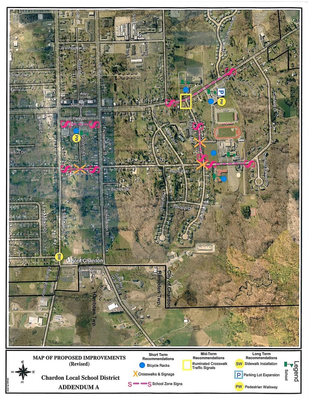
26 SECTION 9: MAPPING Please see the TRM Safe Routes to School Engineering Study and Addendum A in Section 12 for mapping of proposed improvements. Chardon Schools Safe Routes to School Walk and Roll 25
27 CHARDON SCHOOLS - "WALK & ROLL" Action Strategy Name Strategy Detail Time Frame Encouragement Walking Club Physical Education classes to incorporate walking clubs into their curriculum. Mileage is tracked, rewards Responsible Party Status Cost Possible Funding Source Percent of Students Affected 2010 Schools On-Going Low Schools 100% Encouragement Athlete Training Coaches and athletes participate in safety program geared towards learning how to safely run on city and township streets 2010 PE Teachers Planning Low Schools 12% Cross Country / 15% Track Encouragement R & R Provide walking and biking to school rewards and recognition 2010 Schools / PTO On-Going Low ODOT / SRTS 43% Encouragement Walk to School Day Participate in International Walk to School Day Annually in the Fall Schools / PTO Planning Low ODOT / SRTS 43% Education Pedestrian Safety Academy Provide pedestrian safety classes for Elementary Schools and Chardon Middle School 2011 Schools / CPD On-Going Low Schools / City 100% Education Bicycle Safety Academy Provide bicycle safety classes for Elementary Schools and Chardon Middle school 2011 Schools / CPD On-Going Low Schools / City 100% Education Safety Village Conduct two- week summer safety program for students entering kindergarten in the fall 2010 Schools / CPD / Fire Dept. Planning Low Schools 8% Education Media Blitz Provide timely information to local newspapers, school newsletters, website and local cable access regarding pedestrian and bike safety, school zone rules, etc PTO Planning Low PTA's 100% Enforcement Speed Enforcement Increase speed limit enforcement in school zones 2010 Chardon Police Department On-Going Low Chardon Police Department 100% Enforcement Dismissal Coordination Delay walker dismissal times until after school buses leave school grounds 2010 Schools Planning Low Schools 100% Enforcement Police Patrol Deter unsafe behaviors with increased police presence 2010 Chardon Police Department On-Going Low Chardon Police Department 100% Enforcement Crossing Program Develop parent volunteer parking lot crossing program to help students safely arrive on school grounds 2011 PTO Planning Low Schools 46% (excludes St. Mary's) Evaluation Evaluation Monitor Statistics Survey Monitor accident rates in areas around schools Monitor progress of SRTS through surveys at least once per year Annually Chardon Police Department Planning Low Chardon Police Department 100% Annually Schools On-Going Low Schools 100% Evaluation Walk / Bike Participation Monitor student participation in walking and biking events Annually PTO On-Going Low Schools 43% Evaluation SRTS Team Develop an actively engaged SRTS team comprised of city, law enforcement, and school leaders On-Going SRTS Group On-Going Low SRTS Team 100% X:\Local Projects\SRTS\@Projects\D 12\2007 Chardon\STP 2010\Files\04 Step X Spreadsheet xls
28 CHARDON SCHOOLS - "WALK & ROLL" Action Strategy Name Strategy Detail Time Frame Engineering Bike Racks Purchase Bike Racks (2/School) Fall 2010 Responsible Party School Engineering Helmet Lockers Purchase Helmet Lockers Fall 2010 School Engineering Engineering Engineering Engineering Engineering Engineering Crosswalks & Signs Crosswalks & Signs Signage Program Signage Program Ped Walkway Signage Program Crosswalks & Maple Ave. & Chardon Ave. Crosswalks & Chardon Ave. & Memorial Dr. School Zone Signage Chardon Ave. & Memorial Dr. School Zone Signage Maple Ave. Pedestrian Walkway on the Middle School Site School Zone Signage North St. Fall 2010 Fall 2010 Rall 2010 Fall 2010 Fall 2010 Fall 2010 City City City City School City Status Cost Possible Funding Source Planning / Funding Stage Planning / Funding Stage Planning / Funding Stage Planning / Funding Stage Planning / Funding Stage Planning / Funding Stage Planning / Funding Stage Planning / Funding Stage Percent of Students Affected 8000 ODOT / SRTS 43% tbd ODOT / SRTS 43% 6000 ODOT / SRTS 100% 6000 ODOT / SRTS 100% 8000 ODOT / SRTS 100% 8000 ODOT / SRTS 100% ODOT / SRTS 29% 8000 ODOT / SRTS 100% Engineering Crosswalks & Ramps Crosswalk with Huntigton St. & Goodrich Ct. Fall 2010 City Planning / Funding Stage ODOT / SRTS 46% Engineering Engineering Engineering Engineering Engineering Engineering Signage Program Ped Walkway Illuminated Crosswalk Traffic Signal Sidewalk Installation Parking lot improvements & pedestrian walkway School Zone Signage Huntington St. Pedestrian Walkway on the Park Elementary Site Illuminated Pedestrian Crosswalk on North Chardon Ave. Install Traffic Signal at the intersection of North St. & Chardon Ave. Install sidewalk at intersection of Irma Dr. & South Hambden Expand and reconfigure parking lot and Pedestrian Walkway on the Middle School Site Fall 2010 Fall 2010 City School Planning / Funding Stage Planning / Funding Stage 8000 ODOT / SRTS 100% ODOT / SRTS 73% Mid-Term City Research ODOT / SRTS 100% Mid-Term City Research tbd ODOT / SRTS 100% Long-Term City Research tbd ODOT / SRTS 7.40% Long-Term School Research tbd ODOT / SRTS / SCHOOL 23% X:\Local Projects\SRTS\@Projects\D 12\2007 Chardon\STP 2010\Files\04 Step X Spreadsheet xls
29 SECTION 12: SUPPORTING DOCUMENTS Safe Routes to School Engineering Study Transportation Resources Management Addendum A. Revised Map of Proposed Improvements Photographs Maps Parent Surveys Student Travel Summary Reports Chardon Schools Safe Routes to School Walk and Roll
30
31 Ohio Department of Transportation Office of Local Projects Julie Walcoff SRTS Program Manager 1980 West Broad Streeet Columbus, Ohio January 8, 2010 Dear Ms. Walcoff: As Chief of the City of Chardon Police Department, I have been involved in the creation of the Chardon School Travel Plan for the Safe Routes to School program. The working partnership, which has been formed with Chardon local schools, St. Mary School, City of Chardon, and community representatives, is important to create and sustain a safe environment for walking and biking to school. The Department is committed to working with the SRTS committee to implement the plan and to reassess the safety and security of the routes our students use to go to and from school. Promoting healthy, active lifestyles is a positive and important message to convey to the youth of our community. We sincerely appreciate your consideration of future funding requests submitted by the Chardon SRTS committee. Best regards, Timothy McKenna Chief of Police
32
33
34
35
36


37 SAFE ROUTES TO SCHOOL ENGINEERING STUDY MAPLE ELEMENTARY SCHOOL PARK ELEMENTARY SCHOOL SAINT MARY S ELEMENTARY SCHOOL CHARDON MIDDLE SCHOOL OHIO DEPARTMENT OF TRANSPORTATION DISTRICT TWELVE Applicants: CHARDON LOCAL SCHOOL DISTRICT CITY OF CHARDON Date: October 9,
38 Table of Contents Page Executive Summary 1 Existing Conditions 3 Maple Elementary School 6 Chardon Middle School/ St. Mary s Elementary School 7 Park Elementary School 9 Recommended Improvements 12 Short Term Recommendations 12 Mid Term Recommendations 16 Long Term Recommendations 18 Planning Level Opinion of Probable Costs 19 Map of Proposed Improvements 20 Proposed School Route Plan 21 SRTS Engineering Study Chardon Local School District City of Chardon
39 Executive Summary The City of Chardon applied for Safe Routes to School (SRTS) Program funding for four schools: Maple, Park, Saint Mary s Elementary Schools and the Chardon Middle School. Three of the four schools are clustered together in the northern section of the community in an extended academic campus. Park Elementary is located in the center of the city and on its main square, Chardon Square. Local stakeholders gathered input from the public on issues of concern and they also coordinated the exchange of background information between this SRTS engineering study and the Chardon Pedestrian and Bicycle Trail Plan in order to synchronize planning between these pursuits. On August 28, ODOT and the consultant attended a briefing session in Chardon, visited the school sites, and drove throughout the community in order to field verify the stated issues of concern. Based on the above, a set of recommendations was developed to be implemented incrementally: SHORT TERM RECOMMENDATIONS: All Schools: Bicycle Racks on site Maple Elementary School: Crosswalks and Signs (Intersection of Maple Avenue at Chardon Avenue) Crosswalks and Signs (Intersection of Chardon Avenue at Downing Drive) School Zone Signage on Maple Avenue Chardon Middle School/St. Mary s Elementary: Pedestrian Walkway on Chardon Middle School site Crosswalk on North Street between the schools School Zone Signage on North Street Park Elementary School: Crosswalk with ramps (Huntington Street at Goodrich Court) School Zone Signage (Huntington Street) Pedestrian Walkway striping on site MID TERM RECOMMENDATIONS: Maple and Park Elementary Schools: None SRTS Engineering Study Chardon Local School District City of Chardon 1
40 Chardon Middle/St. Mary s Elementary Schools: Illuminated Pedestrian Crosswalk on North Street at Chardon Avenue LONG TERM RECOMMENDATIONS: All Schools: None SRTS Engineering Study Chardon Local School District City of Chardon 2

41 Existing Conditions Chardon Local School District and the City of Chardon applied for Safe Routes to School (SRTS) Program funding for four schools: Maple Elementary, Park Elementary, Saint Mary s Elementary and Chardon Middle School. Three of the four schools Maple and Saint Mary s Elementary Schools and Chardon Middle School are clustered on the north side of the community. Park Elementary School is located in the center of town on the main square (i.e., Chardon Square), which is the commercial, administrative and cultural epicenter of the community. Middle School Maple Elementary St. Mary s Elementary Park Elementary The City of Chardon is currently developing a Pedestrian & Bicycle Plan whose goal is to create connections to local activity centers such as parks, outdoor recreational areas, schools or clusters of activity such as Chardon Square. The plan capitalizes on existing trail segments such as the Maple Highlands Trail and identifies potential corridors for trail development by linking population concentrations and activity centers. Since the trails are envisioned for recreational purposes they are planned away from corridors carrying heavy vehicular volumes. In an era of budgetary constraints, however, location and concept design of these trails remain very flexible in order to qualify them for SRTS Engineering Study Chardon Local School District City of Chardon 3
42 funding from many local and/or state sources, including the SRTS Program if synergies between the two programs are found. For coherent planning between the Chardon Pedestrian & Bicycle Plan and the Safe Routes to School (SRTS) engineering study, the five primary Corridor Alternative Concepts of the Pedestrian & Bicycle Plan were studied for relevance and applicability to the engineering study. The plan identified five primary Corridor Alternative Concepts, each having several options: 1. Maple Highlands Trail Connection (red) 2. School Campus to Chardon Square (yellow) 3. Southern Maple Highlands Trail to Chardon Square (blue) 4. Mel Harder Park to Chardon Square (green) 5. Southwest Development to Square Corridor (purple) Corridors 2, 3, 4 and 5 have the potential to serve the schools. Corridor 2 could serve Maple Elementary, Middle School and Saint Mary s Elementary by linking them with Chardon Square. Corridors 3, 4 and 5 could serve Park Elementary by linking it with neighborhoods to the south, east and west of Chardon Square. Source: D.B. Hart, Inc. SRTS Engineering Study Chardon Local School District City of Chardon 4

43 The Chardon Pedestrian & Bicycle Plan also inventoried existing sidewalks throughout the community and the conclusions were graphically illustrated. Based on this inventory and a site visit to the schools study area, it was concluded that for the most part, neighboring areas from where students can walk to Source: D.B. Hart, Inc. school have at least one sidewalk (on one side of the street) and often two sidewalks (on both sides of the street). Key intersections along the perimeter of the school sites have painted crosswalks, which yield an overall pedestrian environment that is conducive to walking/biking to school. SRTS Engineering Study Chardon Local School District City of Chardon 5

44 Maple Elementary School: The school is located across from the High School and it faces Maple Avenue. Located at the northeastern fringes of Chardon, it is surrounded by residential neighborhoods. A short distance to the north is Chardon Park, which is identified as a public recreation activity center by the Chardon Pedestrian and Bicycle Plan. Corridor Alternative Concept 2 of the Pedestrian and Bicycle Plan was developed in order to serve Chardon Park, the High School and Maple Elementary School. Chardon Ave. Maple Elementary Maple Ave. During the site reconnaissance visit, the following were observed: Intersection of Maple Avenue at Chardon Avenue Crosswalk lines were painted at all approaches but over time they have deteriorated and the paint lines are faded. Crosswalk signs consistent with design standards set forth by the Manual of Uniform Traffic Control Devices were not available. Intersection of Chardon Avenue at Downing Drive Downing Drive collects students from the immediate residential neighborhoods and directs them to the school campus. Being in the path to school for so many students, there is a need for a striped crosswalk and crosswalk signs. School Zone along Maple Avenue The school zone sign program along Maple Avenue between Canfield Road and Chardon Avenue needs to be updated in accordance with the Manual of Uniform Traffic Control Devices and a reduced speed limit zone to be established. SRTS Engineering Study Chardon Local School District City of Chardon 6

45 Chardon Middle School/St. Mary s Elementary School: The schools are located across from each other on North Street; St. Mary s Elementary occupies the west side of North Street and the Middle School is located on the east side. The Middle School site also houses the administrative offices of the Chardon Local School District. Both entities share the same site access points off North Street: a northern access drive, which is designated as inbound only and a southern access drive, which is designated as outbound only. The southern access drive is located across from an access drive serving Saint Mary s Elementary School. Chardon Local School District Offices Chardon Middle School St. Mary s Elementary School During the site reconnaissance visit, the following were observed: Lack of a Walkway on Site - The two driveways serving the Middle School are exceedingly wide for one-way vehicular operations: the width of the northern driveway (inbound only) was estimated at approximately 36 feet, which is wide enough for three driving lanes; the width of the southern SRTS Engineering Study Chardon Local School District City of Chardon 7


46 driveway (outbound only) was estimated approximately 52 feet, which is wide enough for four driving lanes. These pavement widths are more than adequate for more than two vehicles to idle side-by-side. The pavement areas, however, are not used efficiently since there are no lane striping and pavement markings to delineate the driving lanes. Chardon Middle School North North Street St. North Street Lack of Pedestrian Connection - Saint Mary s Elementary School has three access points on North Street. The northern driveway is located across from the southern driveway of the Middle School. St. Mary s Elementary School North St. SRTS Engineering Study Chardon Local School District City of Chardon 8

47 There is no crosswalk across North Street between the two schools. The other two driveways straddle Chardon Avenue. North Street has sidewalks on both sides. The North Street/Chardon Avenue intersection is equipped with striped and signed crosswalks. Pedestrian Crossing on North Street at Chardon Avenue - After the Walkability Meeting, the Chardon Police Department requested the consultant to consider the feasibility of a traffic signal at the intersection of North Street and Chardon Avenue as part of the SRTS engineering study. The request was based on the local viewpoint that a traffic signal at this location would yield safer vehicular and pedestrian conditions at the existing crosswalks. Lack of a School Zone Signage Program - The school zone along North Street does not have a coherent signage program in accordance with the Manual of Uniform Traffic Control Devices. Park Elementary School: The school site is a rectangular elongated land parcel on Chardon Square, next to the Chardon Library. The frontage of the school site is occupied by the Auditorium while the school building has a setback from East Park Street and it could be difficult to find. Goodrich Court is a short roadway segment between East Park Street and Huntington Street and provides access to the school. It is operated as a Source: Chardon Local School District SRTS Engineering Study Chardon Local School District City of Chardon 9


48 one way westbound facility serving school traffic flows. During school operating hours, a gate closes Goodrich Court, which functions as the school s playing ground. During the site reconnaissance visit, the following were observed: Lack of Crosswalk on Huntington Street at Goodrich Court - A crosswalk across Huntington Street at Goodrich Court is currently missing. Lack of a School Zone Signage Program Huntington Street in the school zone does not have a coherent signage program to create visibility for the school. Lack of a Walkway on Site There is no walkway on site for walking students to access the main school entrance, which is located across from the auditorium. In the absence of a walkway on site it is speculated that walking students must use an existing fire lanes, which run on both sides of Goodrich Court along the facades of the buildings. The effective width of the fire lanes, however, is substantially reduced where physical obstructions exist and which take away space that could be used by walking students. Such obstructions are: a protruding fire hydrant, an external staircase serving the auditorium and a set of mechanical equipment probably related to the auditorium. SRTS Engineering Study Chardon Local School District City of Chardon 10


49 Existing Sidewalk Connections Despite the fact that there is no walkway on site, there are pedestrian connections to/from the east and west of the school site linking it with the area s roadway system. On the east there is a sidewalk segment along the north side of Goodrich Court between Huntington Street and the school. The sidewalk abruptly interrupts at the school property line. On the west side there is a sidewalk segment along East Park Street across Goodrich Court. The sidewalk connects with pedestrian facilities throughout Chardon Square, which enables students to safely walk to school from across the square and origins further west. With all these pedestrian connections in place, the missing walkway on site becomes even more warranted. SRTS Engineering Study Chardon Local School District City of Chardon 11


50 A review of historical vehicle crash data contained in the SRTS database revealed that there were very few crashes in the City of Chardon during the period. The recorded incidents were related to human error and poor judgment during a parade on Chardon Square. Recommended Improvements A package of recommendations was developed consisting of individual projects to be implemented in the stages. Short term projects are easily implementable yielding immediate results, mid term projects require additional time to reach consensus among project stakeholders, develop the plans and apply for the necessary funds. Long term projects usually require more time to prepare and they usually are the next step up of short- and mid-term projects. Since the City of Chardon is developing its own Pedestrian and Bicycle Trail Plan, an effort was made to synchronize the study findings with the visions of the plan for more coordinated and coherent overall planning between the state and local governments. SHORT TERM RECOMMENDATIONS: All Schools: Bicycle Racks - It is recommended that bicycle racks are installed by the school entrances in order to encourage student bicycling to school. It is the recommendation of the SRTS Program that inverted U-type bicycle racks be installed although other racks may be proposed provided they meet certain performance requirements: support the SRTS Engineering Study Chardon Local School District City of Chardon 12

 It is recommended that the existing pavement markings delineating the crossing area be refreshed with a new")
51 frame of the bicycle and not just one wheel, allow the frame and one wheel to be locked to the rack when both wheels are left on the bicycle, allow the frame and wheel is removed, allow the use or either a cable or U-shaped lock be securely anchored, be usable by bicycles with no kickstand, be usable by bicycles with water bottle cages, be usable by a wide variety of sizes and types of bicycles. Maple Elementary School: Crosswalk Signs (Intersection of Maple Avenue at Chardon Avenue) It is recommended that the existing pavement markings delineating the crossing area be refreshed with a new coat of paint. In addition, side mounted crosswalk signs in fluorescent yellow-green backgrounds are recommended because such this type of signs is are more conspicuous during dawn, dusk and periods of inclement weather than the standard yellow that are sometimes found in school zones. For high visibility in the school zone, zebra pavement markings should be given some consideration. Crosswalks and Signs (Intersection of Chardon Avenue at Downing Drive For added visibility of this intersection and for consistency with the neighboring intersection of Maple Avenue at Chardon Avenue, the same package of improvements is recommended as above. School Zone Signage on Maple Avenue For added visibility of the school zone along Maple Avenue a package of signs in fluorescent yellow-green background which are often augmented by flashing lights during school operating hours is recommended. The flashing lights can operate on SRTS Engineering Study Chardon Local School District City of Chardon 13


52 solar panel cells or they can be supported from the electrical power network. Their objective is to define the start and end points of the school zone and to reduce the speed limit down to 20 mph. Advance warning signs could also be installed in order to alert motorists of the school zone ahead and the reduced speed limit. These signs are often supplemented by pavement markings displaying the word SCHOOL alerting drivers of the school zone ahead. School zone signs and pavement markings are traditionally placed at the school property boundaries and they could be extended up to 300 feet out (if necessary). Chardon Middle School/St. Mary s Elementary School: Pedestrian Walkway on the Middle School Site A walkway on site is recommended in order to provide a safe walking surface for students away from vehicular traffic and to connect with the existing sidewalks on North Street. Ultimately, pavement markings and a striped walkway on site will result in a more efficient utilization of the existing paved surface on site. The recommended conceptual design concept is graphically illustrated here. Crosswalk on North Street between the Schools In order to complement the recommended walkway on the site of the Middle School, a crosswalk on North Street is proposed. Such a crosswalk will provide connectivity between the two SRTS Engineering Study Chardon Local School District City of Chardon 14
53 schools and it will establish a linkage between the Middle School site, the west side of North Street and Fifth Avenue. It also reflects a request by local stakeholders for a pedestrian connection across North Street between the two schools to facilitate pedestrian movement to/from Fifth Avenue. The crosswalk should be marked by side mounted crosswalk signs in fluorescent yellow-green backgrounds and zebra pavement markings should be given some consideration. The pedestrian signs and zebra pavement marking concepts are shown above. School Zone Signage on North Street - A similar package of pavement markings and signs already presented for the school zone of the Maple Elementary School zone is recommended for the school zone in front of Chardon Middle School and Saint Mary s Elementary School. The goal is to improve the visibility of the schools and to reduce the speed limit down to 20 mph in the school zone. Park Elementary School: Crosswalk with Ramps (Huntington Street at Goodrich Court) Capitalizing on the existing sidewalk segment on the north side of Goodrich Court between Huntington Street and the school, a crosswalk on Huntington Street is recommended. For compliance with ADA recommendations, curb ramps at the two approaches on Huntington Street are also recommended. Finally, as standard components of all crosswalks side mounted signs on fluorescent yellow-green backgrounds and zebra pavement markings are proposed. School Zone Signage on Huntington Street - A similar package of pavement markings and signs to the Maple Elementary School zone is recommended. The goal is to improve the visibility of the school zone on Huntington Street and to reduce the speed limit down to 20 mph. SRTS Engineering Study Chardon Local School District City of Chardon 15


54 Pedestrian Walkway Striping on Site A painted walkway is recommended along the north side of Goodrich Court. The objective is to seamlessly connect with the existing sidewalk along East Park Street and the existing sidewalk segment on Goodrich Court east of the school site. The recommended walkway concept is graphically illustrated here. In order to implement such a concept, the protruding fire hydrant would need to be relocated to an alternate location closer to the outside wall of the school in order to provide unobstructed space for the development of the painted walkway on site. The feasibility and costs of relocating the fire hydrant need to be determined before this project is pursued further. MID TERM RECOMMENDATIONS: Maple and Park Elementary Schools: None Chardon Middle School/St. Mary s Elementary School: Illuminated Pedestrian Crosswalk on North Street at Chardon Avenue The local Police Department requested that a traffic signal is considered at this intersection as part of the SRTS SRTS Engineering Study Chardon Local School District City of Chardon 16


55 engineering study. The Manual of Uniform Traffic Control Devices (MUTCD) calls for Traffic Signal Warrants to be met prior to installing of a traffic signal. The warrants are based on minimum traffic volumes not pedestrian volumes. In order to determine the feasibility of a traffic signal at this intersection, a traffic signal warrant analysis would need to be conducted using up-to-date traffic volume data. Such an analysis is beyond the cope of this SRTS engineering study. An illuminated pedestrian crosswalk was considered by this study as an alternative idea to the requested traffic signal because it is acknowledged that North Street is a major arterial through the community with regional connectivity and some type of traffic management at the intersection with Chardon Avenue is justified. The illuminated pedestrian crosswalk concept is based on the same rationale as the traffic signal, which is the orderly regulation of traffic and pedestrian flows at the intersection. The illuminated crosswalk, however, is justified by pedestrian not vehicular demand. The MUTCD (2003 Edition) defines an illuminated crosswalk (i.e., in roadway lights) as follows: In roadway Lights warn road users that they are approaching a condition on the roadway that might not be readily apparent and might require road users to slow down and/or come to a stop. During early studies prior to acceptance of the In Roadway Lights by the MUTCD, an important consideration was the false sense of security by pedestrians when the in-pavement signal lights were flashing. This is especially relevant to this case where such a concept is being considered for an intersection in a school zone. Recognizing the intent of the in roadway lights to alert motorists of the presence of a pedestrian in the crosswalk, the lights are installed in way to flash way from the pedestrian vision. The lights are SRTS Engineering Study Chardon Local School District City of Chardon 17
56 activated by the pedestrian (i.e., demand driven) and they cease operation at a predetermined time after the pedestrian actuation or with passive detection after the pedestrian clears the crosswalk. LONG TERM RECOMMENDATIONS: All Schools: None SRTS Engineering Study Chardon Local School District City of Chardon 18
 $6,000 Maple Elementary School Chardon Middle School St. Mary s Elementary School Park Elementary School Crosswalks & Signs (Chardon Ave. at Downing Dr.")
57 Planning Level Opinion of Probable Costs School SHORT TERM RECOMMENDATIONS Probable Costs All Bicycle Racks (2 per school) $8,000 Crosswalks & Signs (Maple Ave. at Chardon Ave.) $6,000 Maple Elementary School Chardon Middle School St. Mary s Elementary School Park Elementary School Crosswalks & Signs (Chardon Ave. at Downing Dr.) $6,000 School Zone Signage Program (Maple Ave.) $8,000 Pedestrian Walkway on the Middle School Site $10,000 Crosswalk on North Street between schools $14,000 School Zone Signage Program (North St.) $8,000 Crosswalk with Ramps (Huntington St. at Goodrich Ct.) $14,000 School Zone Signage Program (Huntington St.) $8,000 Pedestrian Walkway on Site (inclusive of fire hydrant relocation) $18,000 TOTAL $100,000 School MID TERM RECOMMENDATION Probable Costs Chardon Middle School St. Mary s Elementary School Illuminated Pedestrian Crosswalk on North St. at Chardon Ave. $30,000 - $50,000 Note: Probable costs are gross approximations for planning and budgeting purposes only. Follow-up cost estimating is required upon further development of each project s scope and design concept. SRTS Engineering Study Chardon Local School District City of Chardon 19
Wellington Exempted Village School District SAFE ROUTES TO SCHOOL TRAVEL PLAN January 2014
 Wellington Exempted Village School District SAFE ROUTES TO SCHOOL TRAVEL PLAN January 2014 OHIO SAFE ROUTES TO SCHOOL WELLINGTON EXEMPTED VILLAGE SCHOOL DISTRICT TRAVEL PLAN SECTION 1: WELLINGTON EXEMPTED
ARCADIA ELEMENTARY & MIDDLE SCHOOLS
 ARCADIA ELEMENTARY & MIDDLE SCHOOLS SAFE ROUTES TO SCHOOL TRAVEL August 2013 ARCADIA LOCAL SCHOOLS OHIO SAFE ROUTES TO SCHOOL SCHOOL TRAVEL Ohio Safe Routes to School Travel Plan Local Schools www.dot.state.oh.us/saferoutes
July 5, Arthur R. Ware, Jr. Elementary School 2017 Safe Routes to School Walkabout Report
 July 5, 2017 Arthur R. Ware, Jr. Elementary School 2017 Safe Routes to School Walkabout Report 1 Walkabout Report Introduction On April 28, 2017, City, School, and SAWMPO staff met to conduct a Safe Routes
PROSPECT ELEMENTARY GIRARD INTERMEDIATE GIRARD JUNIOR HIGH
 PROSPECT ELEMENTARY GIRARD INTERMEDIATE GIRARD JUNIOR HIGH SAFE ROUTES TO SCHOOL SCHOOL TRAVEL PLAN January 8, 2014 2 SECTION 1: OUR SCHOOLS School District School Name School Address Grades served Girard
2 Mark Twain Elementary School Report
 2 Mark Twain Elementary School Report Principal: Greg Kaatz Grades: K-2 Enrollment: 323 Address: 425 N. Church Street First bell: 8:10 a.m. Silverton, OR 97381 Last bell: 2:30 p.m. Free & Reduced Lunch:
Vallecito Elementary School. Travel Plan
 Vallecito Elementary School Travel Plan TABLE OF CONTENTS 1. PURPOSE... 1 1.1. SR2S PLANNING, IMPLEMENTATION AND MONITORING... 1 1.2. MARIN COUNTY MEASURE A... 1 2. VALLECITO ELEMENTARY SCHOOL PROFILE...
Bringing together community and health. Physical Activity and Nutrition Unit Office of Statewide Health Improvement Initiatives
 Bringing together community and health. Physical Activity and Nutrition Unit Office of Statewide Health Improvement Initiatives Physical Activity and Nutrition Unit Office of Statewide Health Improvement
About the Studio. Edward J. Bloustein School of Planning and Public Policy - Rutgers University
 About the Studio Edward J. Bloustein School of Planning and Public Policy - Rutgers University Purpose of studio: Help City of Bayonne apply for Safe Routes to School (SRTS) funding by producing a School
Chapter 2. Bellingham Bicycle Master Plan Chapter 2: Policies and Actions
 Chapter 2 Bellingham Bicycle Master Plan Chapter 2: Policies and Actions Chapter 2: Policies and Actions The Bicycle Master Plan provides a road map for making bicycling in Bellingham a viable transportation
San Ramon Elementary School. Travel Plan
 San Ramon Elementary School Travel Plan TABLE OF CONTENTS 1. PURPOSE... 1 1.1. SR2S PLANNING, IMPLEMENTATION AND MONITORING... 1 1.2. MARIN COUNTY MEASURE A... 1 2. SAN RAMON ELEMENTARY SCHOOL PROFILE...
Safe Routes to School Comprehensive Plan
 Safe Routes to School Comprehensive Plan City of Apple Valley Dakota County, MN May 2010 Prepared by: Project Background The Statewide Health Improvement Program (SHIP) aims to help Minnesotans live longer,
THORNVILLE-GLENFORD STP
 THORNVILLE-GLENFORD STP SAFE ROUTES TO SCHOOL TRAVEL PLAN September 2013 OHIO SAFE ROUTES TO SCHOOL SCHOOL TRAVEL PLAN SECTION 1: OUR SCHOOL/S 1A. Identify Target Schools School District School Name School
Summary Report School Walking & Bicycling Audits. Mesa County Regional Transportation Planning Office
 Summary Report School Walking & Bicycling Audits Mesa County Regional Transportation Planning Office This page left blank intentionally WALKING & BICYCLING AUDIT SUMMARY 2 Executive Summary Background:
Safe Routes to School. Winton Woods City Schools Informational Presentation Public Input Meeting October, 2017
 Safe Routes to School Winton Woods City Schools Informational Presentation Public Input Meeting October, 2017 Presentation Overview What is Safe Routes to School? How is the School Travel Plan developed?
Perryville TOD and Greenway Plan
 Perryville TOD and Greenway Plan Greenway Glossary Pathway: A bicycle and pedestrian path separated from motorized vehicular traffic by an open space, barrier or curb. Multi-use paths may be within the
NM-POLICY 1: Improve service levels, participation, and options for non-motorized transportation modes throughout the County.
 Transportation PRINCE WILLIAM COUNTY 2008 COMPREHENSIVE PLAN NON-MOTORIZED PLAN CONTENTS Goals, Policies, and Action Strategies Table 4 (Bike Facility Classifications and Descriptions) Table 5 (Bike Facility
AMHERST EXEMPTED VILLAGE SCHOOLS AND SAINT JOSEPH SCHOOL
 AMHERST EXEMPTED VILLAGE SCHOOLS AND SAINT JOSEPH SCHOOL SAFE ROUTES TO SCHOOL TRAVEL PLAN 12/11/18 DRAFT OHIO SAFE ROUTES TO SCHOOL SCHOOL TRAVEL PLAN Ohio s Safe Routes to School Travel Plan Template
CHILLICOTHE CITY SCHOOLS. SAFE ROUTES TO SCHOOL TRAVEL PLANS for Allen, Mt. Logan, Tiffin & Worthington Elementary Schools January 2013
 CHILLICOTHE CITY SCHOOLS SAFE ROUTES TO SCHOOL TRAVEL PLANS for Allen, Mt. Logan, Tiffin & Worthington Elementary Schools January 2013 i Ohio s Safe Routes to School Travel Plan Template www.dot.state.oh.us/saferoutes
Safe Routes to School Travel Plan 2011 Reading-Fleming Intermediate School (RFIS)
") Safe Routes to School Travel Plan 0 Reading-Fleming Intermediate School (RFIS) Reading Fleming Intermediate School 50 Court Street Flemington, NJ 088 Grades: 5-6 Introduction Reading-Fleming Intermediate
Safe Routes to School Travel Plan 0 Reading-Fleming Intermediate School (RFIS) Reading Fleming Intermediate School 50 Court Street Flemington, NJ 088 Grades: 5-6 Introduction Reading-Fleming Intermediate
SAFE ROUTES TO SCHOOL
 SAFE ROUTES TO SCHOOL Forest Ridge Elementary School Existing Conditions and ACTION PLAN > Oak Creek - Franklin Joint School District Table of Contents CONTEXT Enrollment Boundaries
Implementing the Three Es of School Zone Traffic Calming
 Implementing the Three Es of School Zone Traffic Calming Use this evaluation tool as a guide to analyze the specific safety needs of your school. SCHOOL PROFILE School Name: School District: Address: Phone
CITY OF OAK CREEK SAFE ROUTES TO SCHOOL ACTION PLAN. East Middle School
 CITY OF OAK CREEK SAFE ROUTES TO SCHOOL ACTION PLAN East Middle School CITY OF OAK CREEK SAFE ROUTES TO SCHOOL ACTION PLAN East Middle School Why Safe Routes to School? Safe Routes to School ( SRTS ) is
SAFE ROUTES TO SCHOOL
 SAFE ROUTES TO SCHOOL Edgewood Elementary School Existing Conditions and ACTION PLAN > Oak Creek - Franklin Joint School District Table of Contents CONTEXT Enrollment Boundaries Enrollment
Summary of School Observations and Education and Encouragement Initiatives
 Rye Shared Committee Summary of School Observations and Education and Encouragement Initiatives Presented to the Rye City Council & The Rye City School District Board of Education April 9 th, 2011 1 Why
Safe Routes to School
 Safe Routes to School Amy Paxton-Aiken, Center TRT University of North Carolina Chapel Hill, NC and Ian Thomas, Executive Director PedNet Coalition Columbia, MO Housekeeping If you are calling in on a
Safe Routes to School Guide
 Safe Routes to School Guide Steps to Creating a Safe Routes to School Program Created February 2007 SafeRoutes National Center for Safe Routes to School This guide was developed by the Pedestrian and Bicycle
EXECUTIVE SUMMARY. Vision
 Vision Walking and bicycling in Salt Lake City will be safe, convenient, comfortable, and viable transportation options that connect people to places, foster recreational and economic development opportunities,
3 Silverton High School Report
 3 Silverton High School Report Principal: Justin Lieuallen Grades: 9-12 Enrollment: 1,277 Address: 1456 Pine Street First bell: 7:55 a.m. Silverton, OR 97381 Last bell: 3:05 p.m. Free & Reduced Lunch:
Chapter 5. Complete Streets and Walkable Communities.
 Chapter 5. Complete Streets and Walkable Communities. 5.1 Description of Complete Streets. Cities throughout the world, and specifically the United States, are coming to embrace a new transportation and
Bikeway action plan. Bicycle Friendly Community Workshop March 5, 2007 Rochester, MN
 Bikeway action plan Summary The was held on March 5, 2007 at the Rochester Mayo Civic Center. The workshop was hosted by Rochester-Olmsted County Planning Department in collaboration with the League of
Chapter 3.9 Timbercrest Elementary School. Volusia County MPO. November 2008
 Chapter 3.9 Timbercrest Elementary School Deltona, FL Volusia County MPO November 2008 Volusia County MPO School Bicycle and Pedestrian Review Study, Phase 3B School Summary Timbercrest Elementary School
Hedgepeth Williams Middle School and Paul Robeson Elementary School Trenton, NJ. School Travel Plan
 Hedgepeth Williams Middle School and Paul Robeson Elementary School Trenton, NJ School Travel Plan Hedgepeth Williams Middle School Description: Hedgepeth-Williams Middle School is located at 301 Gladstone
Get Oregon kids. Walking, biking and rolling to school planning guide
 Get Oregon kids Walking, biking and rolling to school planning guide The Oregon Health Authority produced this guide with assistance from the Oregon Department of Education, Oregon Department of Transportation
FREMONT CITY SCHOOLS STP
 FREMONT CITY SCHOOLS STP SAFE ROUTES TO SCHOOL TRAVEL PLAN February 2014 OHIO SAFE ROUTES TO SCHOOL SCHOOL TRAVEL PLAN SECTION 1: OUR SCHOOL(S) 1A. Identify Target Schools School District School Name School
AGENDA. 5. Next Steps a. Survey Distribution b. Draft Action Plan/Recommendations c. Review at next meeting in advance of document preparation
 Congdon Elementary Safe Routes to School Plan Update SRTS Team Meeting #2-Walk Audit March 21, 2018, 3:00 p.m. Congdon Elementary School Art Room-Duluth, MN 1. Welcome and Introductions 2. SRTS Review
Safe Routes to School Grant Application Phase I March 2014
 Safe Routes to School Grant Application Phase I March 2014 Page 1 The City of Mission is requesting grant funding to create a Safe Routes to School Plan which will encompass all of the existing elementary
Rim Rock Elementary School Walking and Biking Audit
 Rim Rock Elementary School Walking and Biking Audit September 29, 2016 Rim Rock Elementary School Audit for Walking and Biking September 29, 2016 Audit Team Members: Sam Atkins, City Engineer, City of
Corpus Christi Metropolitan Transportation Plan Fiscal Year Introduction:
 Introduction: The Safe, Accountable, Flexible, Efficient Transportation Equity Act: A Legacy for Users (SAFETEA-LU) has continued the efforts started through the Intermodal Surface Transportation Efficiency
Introduction.
 2307-1.0. Introduction. Delaware s Safe Routes to School (SRTS) Program was established September 10, 2002 when Governor Ruth Ann Minner signed Senate Bill 353 of the 141st General Assembly of Delaware
BETHEL ROAD AND SEDGWICK ROAD CORRIDOR STUDY
 DRAFT PLAN City Council Meeting August 14, 2017 STUDY AREA Sedgwick Corridor State Route 160, principal arterial with Class 3 access management designation, commuter and freight route, connection to SR
FRANKLIN, ISHAM MEMORIAL, OVERLOOK & VALLEY VIEW ELEMENTARY SCHOOLS
 FRANKLIN, ISHAM MEMORIAL, OVERLOOK & VALLEY VIEW ELEMENTARY SCHOOLS SAFE ROUTES TO SCHOOL TRAVEL PLAN August 2013 OHIO SAFE ROUTES TO SCHOOL SCHOOL TRAVEL PLAN SECTION 1: OUR SCHOOL(S) School District
Venetia Valley Elementary School. Travel Plan
 Venetia Valley Elementary School Travel Plan TABLE OF CONTENTS 1. PURPOSE... 1 1.1. SR2S PLANNING, IMPLEMENTATION AND MONITORING... 1 1.2. MARIN COUNTY MEASURE A... 1 2. VENETIA VALLEY ELEMENTARY SCHOOL
Arlington Public Schools Thomas Jefferson Site Evaluation Transportation Networks. Thomas Jefferson Working Group Meeting #6 November 10, 2014
 Arlington Public Schools Thomas Jefferson Site Evaluation Transportation Networks Thomas Jefferson Working Group Meeting #6 November 10, 2014 2 3 INTRODUCTION 4 Goal of our work: Identify and assess multi-modal
City of Novi Non-Motorized Master Plan 2011 Executive Summary
 City of Novi Non-Motorized Master Plan 2011 Executive Summary Prepared by: February 28, 2011 Why Plan? Encouraging healthy, active lifestyles through pathway and sidewalk connectivity has been a focus
Bike To School Day Resource Guide 2012
 Bike To School Day Resource Guide 2012 TABLE OF CONTENTS Brief History of Bike to School Day... 3 Introduction... 5 Why Bike To School?... 5 Suggested Activities for Bike to School Day... 7 Bike To School
CHAPTER 3: Vision Statement and Goals
 Davidson Walks & Rolls: Active Transportation Master Plan CHAPTER 3 Contents: Overview Vision Statement Measurable Goals Public Outreach CHAPTER 3: Vision Statement and Goals Overview The vision statement
FLETCHER AVENUE PEDESTRIAN AND BICYCLIST BEHAVIOR CHANGE FORMATIVE RESEARCH PROJECT
 FLETCHER AVENUE PEDESTRIAN AND BICYCLIST BEHAVIOR CHANGE FORMATIVE RESEARCH PROJECT EXTENT OF CHANGES IN PEDESTRIAN AND BICYCLIST ATTITUDES AND BEHAVIORS DIRECTLY AFTER A COMPLETE STREETS PROJECT IN FLORIDA
BIKE PLAN CONTENTS GATEWAY
 CONTENTS Acknowledgments...vii Great Rivers Greenway District Board of Directors... vii Great Rivers Greenway District Staff... vii Project Consultants... vii Committees... viii Citizens Advisory Committee
Non-Motorized Transportation 7-1
 Non-Motorized Transportation 7-1 Transportation facilities no longer mean just accommodating a vehicle powered by a combustion engine. Pedestrian and non-motorized facilities are important modes of travel
WALKSacrame nto. Welcomes you to the 2009 Sacramento County Safe Routes to School Conference
 Sacramento County Department of Transportation Ron Vicari, Principal Civil Engineer In Partnership with: WALKSacrame nto Anne Geraghty, Terry Preston & Staff Welcomes you to the 2009 Sacramento County
PEDESTRIAN ACTION PLAN
 ATTACHMENT 2 CITY OF SANTA MONICA PEDESTRIAN ACTION PLAN CITY OF SANTA MONICA PEDESTRIAN ACTION PLAN This page intentionally left blank EXECUTIVE SUMMARY CHAPTER 1 EXECUTIVE SUMMARY Setting the Stage
SAFE ROUTES TO SCHOOL (SR2S)
") SAFE ROUTES TO SCHOOL (SR2S) In partnership with Burbank Unified School District (BUSD) & City of Burbank George Washington Elementary School Thomas Jefferson Elementary School John Muir Middle School
SAFE ROUTES TO SCHOOL (SR2S) In partnership with Burbank Unified School District (BUSD) & City of Burbank George Washington Elementary School Thomas Jefferson Elementary School John Muir Middle School
Bremen Elementary. SAFE ROUTES TO SCHOOL TRAVEL PLAN October 9, 2012
 Bremen Elementary SAFE ROUTES TO SCHOOL TRAVEL PLAN October 9, 2012 Introduction The purpose of the Bremen Elementary Safe Route to School (SRTS) Plan is to encourage school age children to travel to school
BEVERLY GARDENS ELEMENTARY SCHOOL TRAVEL PLAN
 BEVERLY GARDENS ELEMENTARY SCHOOL TRAVEL PLAN City of Riverside, Ohio Ohio Safe Routes to School Plan INDEX SECTION 1: TARGET SCHOOLS AND THE SAFE ROUTES TO SCHOOL TEAM SECTION 2: INTRODUCTION SECTION
SECTION 1 - CONTACT INFORMATION
 SECTION 1 - CONTACT INFORMATION Please complete the information below. The person identified as the Project Contact Person will be the primary point of contact for Georgia DOT staff. Organization: (Please
ASHTABULA AREA SCHOOLS STP
 ASHTABULA AREA SCHOOLS STP SAFE ROUTES TO SCHOOL TRAVEL PLAN April 2013 OHIO SAFE ROUTES TO SCHOOL SCHOOL TRAVEL PLAN SECTION 1: OUR SCHOOL/S 1A. Identify Target Schools School District School Name School
James Williams Middle School 915 Acacia Lane
 James Williams Middle School 915 Acacia Lane Grades Served: 6 th -8 th Student Geography According to an address analysis of students, 36.7% of students attending JWMS live within 2 miles of school (see
C/CAG. Sunnybrae Elementary School Walking and Bicycling Audit. San Mateo-Foster City School District JUNE 2013
 Sunnybrae Elementary School Walking and Bicycling Audit JUNE 2013 San Mateo-Foster City School District C/CAG City/County Association of Governments of San Mateo County SUNNYBRAE ELEMENTARY SCHOOL WALKING
City of Vineland Safe Routes to School Travel Plan
 April 1, 2014 2014 City of Vineland Safe Routes to School Travel Plan Gloria M. Sabater Elementary School 4/1/2014 Contents Introduction 1 School Description 1 Existing Policies and Practices 2 Walk/Bike
Sardis Elementary School Road Safety Plan. Produced by: Sardis Elementary School - Safer School Travel Team in cooperation with Safer City
 Sardis Elementary Road Safety Plan Produced by: Sardis Elementary - Safer Travel Team in cooperation with Safer City Plan completed in January 2016 1 Acknowledgements It takes commitment and community
Memorandum. Public Comments
 711 SE Grand Ave. Portland, OR 97214 (503) 230-9862 www.altaplanning.com Memorandum Date: November 30, 2016 To: From: Re: City of Tacoma Hannah Day-Kapell and Gena Gastaldi, Alta Planning + Design Tacoma
Broad Street Bicycle Boulevard Design Guidelines
 Broad Street Bicycle Boulevard Design Guidelines Building from the strategies introduced in the 2013 Bicycle Transportation Plan and community input received thus far, City Transportation Staff have identified
City of Birmingham Draft Multi-modal Transportation Plan
 City of Birmingham Draft Multi-modal Transportation Plan City Commission Public Hearing Monday, November 25, 2013 7:30 pm Norman Cox, PLA, ASLA The Greenway Collaborative, Inc. Ann Arbor, Michigan The
Doull Elementary School
 Doull Elementary School Safe Routes to School Walking Audit and Recommendations WalkDenver Fall 2013 Doull Elementary School (ECE grade 5) 2520 South Utica Street, Denver 80219 This project was supported
EMPHASIS AREA 2: SCHOOL CHILDREN
 EMPHASIS AREA 2: SCHOOL CHILDREN A child is seriously injured or killed every 17 weeks on their way to or from school on Toronto s roads. School children are pedestrians and cyclists between the ages of
NORTH UNION LOCAL SCHOOLS
 NORTH UNION LOCAL SCHOOLS SAFE ROUTES TO SCHOOL TRAVEL PLAN November 2015 OHIO SAFE ROUTES TO SCHOOL SCHOOL TRAVEL PLAN SECTION 1: OUR SCHOOL(S) 1A. Identify Target Schools School District School Name
TRAVEL PLAN: CENTRAL EUROPEAN UNIVERSITY CAMPUS REDEVELOPMENT PROJECT TRAVEL PLAN. Central European University Campus Redevelopment Project.
 TRAVEL PLAN Central European University Campus Redevelopment Project Page 1 Table of Contents Introduction... 3 Background... 7 Building Users... 7 Transportation in Community Consultation... 7 Summary
Bridgewater Complete Streets Prioritization Plan and Pedestrian Safety Assessment
 Bridgewater Complete Streets Prioritization Plan and Pedestrian Safety Assessment Presented by Luciano Rabito Manager of Complete Streets Presented to Bridgewater, MA Wednesday, April 26, 2017 6:30 P.M.
Childhood Obesity: A Policy Perspective
 Leadership for Healthy Communities Advancing Policies to Support Healthy Eating and Active Living Childhood Obesity: A Policy Perspective Elizabeth Hinman elizabeth@leadershipforhealthycommunities.org
Active Transportation Facility Glossary
 Active Transportation Facility Glossary This document defines different active transportation facilities and suggests appropriate corridor types. Click on a facility type to jump to its definition. Bike
Lee s Summit Road Improvement Study Public Open House June 7, 2007 Summary of Comment Card Responses
 Lee s Summit Road Improvement Study Public Open House June 7, 2007 Summary of Comment Card Responses Introduction At the Lee s Summit Road Improvement Study Public Open House held Thursday, June 7, 2007
Background and Goals of SRTS
 Safe Routes to School Background and Goals of SRTS Oklahoma Kick-off May 4, 2011 The Good, the Bad, and the Ugly Fewer kids are biking and walking More parents are driving 1969 2009 48% walked or biked
5. Pedestrian System. Accomplishments Over the Past Five Years
 5. Pedestrian System Accomplishments Over the Past Five Years The Alamo Area Metropolitan Planning Organization (MPO) and its partner agencies recognize the importance of improving pedestrian mobility.
TOWN OF PORTLAND, CONNECTICUT COMPLETE STREETS POLICY
 TOWN OF PORTLAND, CONNECTICUT COMPLETE STREETS POLICY I. VISION, GOALS & PRINCIPLES VISION To improve the streets of Portland making them safer and more accessible for all users including pedestrians,
GRAHAM PEDESTRIAN TRANSPORTATION PLAN
 GRAHAM PEDESTRIAN TRANSPORTATION PLAN Chapter 1 I 1.1 Scope and Purpose n March of 2005, the City of Graham contracted with Greenways Incorporated (GWI) to create a Pedestrian Transportation Plan. The
Traffic Impact Memorandum. May 22, 2018
 BISHOP PROFESSIONAL DEVELOPMENT BUILDING Proposed Land-use Change & Parking Modification 3601 SW 31st Street Topeka, Kansas 66614 CFS Project No. 185077 Traffic Impact Memorandum May 22, 2018 Prepared
Grandview Heights Safe Routes to School School Travel Plan Ohio Department of Transportation, District 6 February 23, 2012
 Grandview Heights Safe Routes to School School Travel Plan Ohio Department of Transportation, District 6 February 23, 2012 Grandview Heights School Travel Plan (STP) Safe Routes to School Table of Contents
Village of Caldwell Safe Routes to School School Travel Plan Ohio Department of Transportation, District 10 May 31, 2012
 Village of Caldwell Safe Routes to School School Travel Plan Ohio Department of Transportation, District 10 May 31, 2012 Caldwell School Travel Plan (STP) Safe Routes to School Table of Contents Part 1:
Chapter 7. Transportation. Transportation Road Network Plan Transit Cyclists Pedestrians Multi-Use and Equestrian Trails
 Chapter 7 Transportation Transportation Road Network Plan Transit Cyclists Pedestrians Multi-Use and Equestrian Trails 7.1 TRANSPORTATION BACKGROUND The District of Maple Ridge faces a number of unique
Sistrunk Corridor DOTMOCRACY SUMMARY
 DOTMOCRACY SUMMARY The TOUCH initiative is a true collaborative working with multi- sector community organizations and agencies to reduce tobacco use and exposure to secondhand smoke, improve access to
Montana Safe Routes to School. Encouraging Active Lifestyles
 Montana Safe Routes to School Encouraging Active Lifestyles SRTS Coordinator Taylor Lonsdale, PE taylor.lonsdale@coe.montana.edu (406) 994-7031 Call me! It s my job to help you. The need for Safe Routes
CONNECTIVITY PLAN. Adopted December 5, 2017 City of Virginia Beach
 CONNECTIVITY PLAN Adopted December 5, 2017 City of Virginia Beach CONTENTS 1.0 Background & Purpose... 2 2.0 Existing Inventory & Analysis... 3 ViBe District Existing Walking Conditions... 4 3.0 ViBe District
Safe Routes to School NELLIE STONE JOHNSON COMMUNITY SCHOOL
 December 2010 Safe Routes to School NELLIE STONE JOHNSON COMMUNITY SCHOOL Encouraging walking and biking to school Safe Routes to School: Healthy Kids Focused Students Across the nation, communities are
Iowa's Bicycle and Pedestrian Encouragement Guide
 1 Iowa's Bicycle and Pedestrian Encouragement Guide Developed by the Iowa Bicycle Coalition for the Iowa Department of Transportation Safe Routes to School Program Acknowledgment Iowa's Bicycle and Pedestrian
OCEAN DRIVE ELEMENTARY SCHOOL
 OCEAN DRIVE ELEMENTARY SCHOOL North Myrtle Beach, SC Safe Routes to School Travel Plan JANUARY 2017 SRTS Team Roster SRTS Team members represent key community stakeholders, share work of developing the
Safe Routes to School in New Jersey
 Safe Routes to School in New Jersey The need for Safe Routes to School 1. Fewer kids today walk and bike to school 2. Unintended consequences have resulted 3. SRTS programs can be part of the solution
RESOLUTION NO ?? A RESOLUTION OF THE CITY OF NEPTUNE BEACH ADOPTING A COMPLETE STREETS POLICY
 RESOLUTION NO. 2018-?? A RESOLUTION OF THE CITY OF NEPTUNE BEACH ADOPTING A COMPLETE STREETS POLICY WHEREAS, safe, convenient, and accessible transportation for all users is a priority of the City of Neptune
Hennepin County Bicycle and Pedestrian Planning
 Hennepin County Bicycle and Pedestrian Planning 1 Value of bicycle and sidewalk systems Safety Livability Mobility Health Personal Finances Economic Sustainability Clean Air Recreation Parking and congestion
Safe Routes to School Action Plan Aberdeen, Idaho
 Background Aberdeen, Idaho is a largely agricultural community of nearly 2,000 people and is located in the southeast portion of the state on the western edge of American Falls Reservoir. The community
Mayor s Bicycle Advisory Council. Wednesday, December 13 th, 2017
 Mayor s Bicycle Advisory Council Wednesday, December 13 th, 2017 Bicyclist Fatalities, Year to Date (January 1 November 30, 2017) - MBAC Briefing Bicyclist Fatality Statistics Year to date total, 2017
Barnum- Safe Routes to School Meeting #2 January 20, 2015
 Barnum- Safe Routes to School Meeting #2 January 20, 2015 1. Introductions 2. SRTS Program Overview 1. Purpose 2. Benefits 3. Background of planning Process 3. Existing Conditions Review and Summary 1.
CONNECTING PEOPLE TO PLACES
 CONNECTING PEOPLE TO PLACES 82 EAST BENCH MASTER PLAN 07 Introduction The East Bench transportation system is a collection of slow moving, treelined residential streets and major arteries that are the
Improvements Infrastructure Gap Assessment and Improvements Street Striping
 Infrastructure Project Proposal The federal-aid Safe Routes to School program funds infrastructure/engineering projects that fall into two categories: Design (available only to School Development Authority
Windom Area Schools District #177 Safe Routes to School Plan Winfair Elementary & the Middle School January 2014
 Windom Area Schools District #177 Safe Routes to School Plan Winfair Elementary & the Middle School January 2014 Prepared by: Southwest Regional Development Commission 2401 Broadway Avenue, Suite 1 Slayton,
Aitkin School Routing Plan July 2010
 Aitkin School Routing Plan July 2010 Prepared by: Arrowhead Regional Development Commission Regional Planning Division Aitkin School Routing Plan July 2010 Aitkin School Routing Plan July 2010 Prepared
Safe Routes to School Comprehensive Plan
 Safe Routes to School Comprehensive Plan City of Rosemount Dakota County, MN June 2010 Prepared by: Project Background The Statewide Health Improvement Program (SHIP) aims to help Minnesotans live longer,
Bicycle Pedestrian Master Plan Pre Bid Meeting Portsmouth, NH August 15, 2013
 Bicycle Pedestrian Master Plan Pre Bid Meeting Portsmouth, NH August 15, 2013 2005 Master Plan GOAL: Provide for safe and convenient bicycle and pedestrian circulation throughout the City. Develop a city
Chicago Pedestrian and Bicycle Safety Initiative Final Report
 1 Chicago Pedestrian and Bicycle Safety Initiative Final Report Chicago Department of Transportation www.chicagocompletestreets.org 312.744.8147 Executive Summary Since 2001, the Chicago Department of
Getting Your SRTS Project Funded. Ryan Snyder
 Getting Your SRTS Project Funded Ryan Snyder Steps in Submitting a Successful Application 1. Stakeholder outreach: create a SRTS coalition 2. Develop a comprehensive plan and program with all 5 Es 3. Conceive
Safe and Active Routes to School in Cabarrus County
 Safe and Active Routes to School in Cabarrus County In 2014, Cabarrus Health Alliance became the host agency for the Charlotte region s coordinator in the NC Active Routes to School program. The NC-ARTS