BEVERLY GARDENS ELEMENTARY SCHOOL TRAVEL PLAN
|
|
|
- Beryl Stevenson
- 6 years ago
- Views:
Transcription


1 BEVERLY GARDENS ELEMENTARY SCHOOL TRAVEL PLAN City of Riverside, Ohio Ohio Safe Routes to School Plan INDEX SECTION 1: TARGET SCHOOLS AND THE SAFE ROUTES TO SCHOOL TEAM SECTION 2: INTRODUCTION SECTION 3: THE PUBLIC INPUT SECTION 4: SCHOOL DEMOGRAPHICS SECTION 5: CURRENT SCHOOL TRAVEL ENVIRONMENT SECTION 6: BARRIERS TO ACTIVE TRANSPORTATION SECTION 7: CREATING SOLUTIONS SECTION 8: IMPROVEMENTS MAPPING SECTION 9: THE ACTION PLAN SECTION 10: PLAN ENDORSEMENTS
2 BEVERLY GARDENS SAFE ROUTES TO SCHOOL PLAN SECTION 1: TARGET SCHOOLS AND THE SAFE ROUTES TO SCHOOL TEAM School Name: Beverly Gardens Elementary School Street Address: 5555 Enright Avenue, Riverside, Ohio Number of students in K-4: 375 for the school year PRIMARY CONTACT: Name: Cristi Fields, Principal Mailing Address: 5555 Enright Avenue, Riverside, Ohio Phone: Name Affiliation Program Area Cristi Fields School Principal Education, Encouragem ent Stan School Education, Bochenek Maintenance Engineering Supervisor Dan Decerbo Transportation Education, Director Engineering Contact Information Bob Murray City of Riverside Engineering Police Chief Mark Reiss Michael Dalton Caroline Duffy Riverside Police Dept. Wright Patterson Air Force Base, Military Housing Traffic Engineering Consultant Enforcement Enforcement/ Engineering Engineering/ Evaluation , ext
3 SECTION 2: INTRODUCTION The name of the School Travel Plan for the Beverly Gardens Elementary School is Better Travels to BG. Beverly Gardens Elementary School does not provide bus service to the school, except for handicap students. As a result, students either walk, ride a bike or take a car to get to and from school. The school experiences severe congestion at arrival and dismissal times when the popular mode of is motorized vehicles, and not walking or bike riding. For this reason, Beverly Gardens Elementary School was chosen for a School Travel Plan to remove the barriers for walkers and bike riders, and thus reduce the congestion surrounding the school. The Task Force and Stake Holders List were developed from a group of individuals who could offer valuable insight into the school environment based on their areas of expertise and personal interests. The Task Force is comprised of school officials, community members, school parents, government officials, and school consultant. The Task Force and Stake Holders Members are as follows: TASK FORCE AND STAKE HOLDERS MEMBERS Name Affiliation Program Area Cristi Fields School Principal Education, Encouragement Eric Bostick PE Teacher Education, Encouragement Ruth Taylor PTO President Education, Encouragement Anita Lucas Safety Patrol Advisor Education, Encouragement Stan Bochenek School Education, Maintenance Supervisor Engineering Contact Information cristal.fields@madriverschools.org eric.bostick@madriverschools.org rrsdtaylor@gmail.com anita.lucas@madriverschools.org stan.bochenek@madriverschools.org Dan Decerbo Transportation Director Education, Engineering dan.decerbo@madriverschools.org Bob Murray City of Riverside Engineering rmurray@riverside.oh.us Michael Dalton Wright Patterson Air Force Base, Engineering Michael.Dalton@mvg.com , ext. 104 Military Housing Officer Mark Riverside Police Dept. Enforcement mark.reiss@madriverschools.org Reiss Caroline Duffy Traffic Engineering Consultant Engineering, Evaluation CDuffy@barreng.com

4 SECTION 3: PUBLIC INPUT PROCESS Beverly Gardens Elementary School is located at 5555 Enright Avenue; Riverside, Ohio, Beverly Gardens Elementary School had 375 students that range from Kindergarten to 4 th Grade for the school years. Beverly Gardens Elementary School is part of the Mad River School District, which includes four other Elementary Schools. The Wright Patterson Air Force Base is located nearby and base housing is adjacent to the school. As a result, a large number of children have parents in the military. All students start at 8:00 AM Beverly Gardens Elementary School. The Kindergarten Students are dismissed at 2:00 PM. while Grades 1-4 dismiss at 2:10 PM. Existing Encouragement Programs The City of Riverside Health & Safety Committee has two Bike Rodeos a year. The first rodeo was at Beverly Gardens on May 21, 2011 between 11 and 1. The second rodeo is typically held at Rorher Park each June. Each of the participants is asked to ride through an obstacle course that was supplied by AAA. All of the children receive free bike helmets. Free hot dogs and juice are also supplied to all the participants. The local Ponderosa Restaurant donates two bikes to the event that are given away. WPAFB sends helps by sending over Mc Gruff the Crime Dog. Public Involvement Parents are supportive of these efforts and will aid with providing safe routes to school for all students of Beverly Gardens. An address, beverlygardenssrts@gmail.com, was set up for parents to their concerns with having the students walk or bike to school. ODOT's Safe Routes to School (SRTS) program has re-enforced the commitment of the Task Force and Stake Holder Members to identify and improve safe, walkable routes for all students. The Task Force and Stake Holder Members were asked a series of questions concerning Beverly Gardens Elementary School on March 17, ODOT's Safe Routes to School (SRTS) program has re-enforced the commitment of the Task Force and Stake Holder Members to identify and improve safe, walkable routes for all students. The Task Force is comprised of a creative, diverse, and motivated team seeking to make further improvements to the health, livelihood, and safety of every student attending Beverly Gardens Elementary School. These efforts to gather the crucial information from the public to provide baseline data have offered innovative and creative 3
5 alternatives to several problems areas. The following is a summary of the questions and answers. 1Q. What operational and physical improvements within 2 miles of schools should be made to establish safer and fully accessible crossings, walkways, trails and bikeways? Answers to Question 1 (answers in bold represent more than one response) 1. Reconfigure Trunk Drive entrance. 2. Visible no parking/stopping and no idling signs in front of school. 3. Create bike paths and walking trails to the school. 4. School crossing signs. 5. Ensure that paths are properly marked. 6. Slow traffic along Spinning Road. 7. Connect the neighborhoods on both sides of Spinning Road. 8. Sidewalks are needed along Enright Avenue from the school to Spinning Road. 9. Adult Crossing Guards at Spinning Road. 10. Adult Crossing Spinning Road and Chapel Lane. 11. School crossing sign at Hickam Drive and Trunk Drive. 12. Crosswalks need to be more visible. 13. Sidewalks from the school heading north and west. 14. Work with Base Housing to establish more entries through the fence. 15. Work with Base Housing to review drop off/pick up area on Trunk Drive inside the WPAFB fence. 16. Parents should not access rear parking area against student crossing guards. 2Q. What education projects that primarily focus on personal safety, as well as the mechanics of walking or bike riding to and from school, should be implemented? Answers to Question 2 (answers in bold represent more than one response) 1. Stranger Danger Awareness Programs. 2. Bike Riding Clinic, including use of bike helmets. 3. Bike Rodeo. 4. Crossing Street Training including with Crossing Guards. 5. Police to provide training. 6. Creation of a SRTS Map showing designated routes. 7. Participation in the International Walk to School Day event. 8. Walking groups (similar to carpool). 9. Parent education and involvement. 3Q. What encouragement projects do you suggest that will encourage and focus on the benefits of walking or bike riding to and from school? Answers to Question 3 (answers in bold represent more than one response) 1. Offer prizes such as tee-shirts, books, bikes, scooters and/or roller skates 4
6 for walking or riding to school. 2. Get Fit Club. 3. Earth Day Program Celebration. 4. Walking Group. 5. Bike Decorating Day. 6. Mileage log for each student to record walks and rides. 7. Physical fitness day incorporating bikes and walking. 8. Parent Walk your Kid to school day. 9. Bike Mechanics Day sponsored by a local bike shop. 10. Create a bike park with trails and BMX course close to the school. 11. Bike Hike on one of the Five Rivers Trails. 12. Gift cards to families that come up with family projects that encourage fitness. 4Q. What enforcement of traffic laws and initiating community enforcement such as crossing guard training programs, should be implemented? Answers to Question 4 (answers in bold represent more than one response) 1. Enforcement of no parking/stopping in front of school. 2. Crossing Guard Training Programs. 3. Snow removal on sidewalks. 4. Training of student crossing guard by the police or AAA.. 5. Modified neighborhood watch group training to provide assistance through-out the neighborhood. 6. Police Officer Day. 7. EMS Day. 8. Speed Violator Hot Line signs on appropriate streets. 9. Properly working traffic signals. 10. Reward students for involvement. 11. Parents to volunteer as Crossing Guards. 12. Community program about traffic laws. 13. No Parking Zone for handicap buses. 5Q. Do you have a suggestion for the name for the plan for Beverly Gardens Elementary School that would suit your school or community situation? It should explain the main motivations for improving walking and bicycling to school. Answers to Question 5 (answers in bold represent more than one response) 1. Beverly Gardens Village Movement. 2. Peddle Stepper Safety Program. 6Q. Should the group plan for SRTS be a single school, district-wide or at another level? Answer to Question 6 (answers in bold represent more than one response) 1. Single School 5
7 7Q. How can we encourage parent involvement? Answers to Question 7 (answers in bold represent more than one response) 1. PTO involvement. 2. Have parents train other parents. 3. Reward parents. 4. Increase student enthusiasm 5. Include parents in the planning staged to implementation. 6. Have a parents only party to explain SRTS. 7. Relate walking/biking to gas savings. 8. Show time commitment for walking vs. driving. 9. Education parents on potential improvements that can be made. 10. Communicate goals and actions to the parents. 11. Discount on School Fees. 12. Reward the student if the parent participates. 13. Give extra ticket to parent if they participate. 8Q. What challenges do you think the children will face in your area in biking and walking to school? Answers to Question 8 (answers in bold represent more than one response) 1. Traffic by the school. 2. Lack of adult supervision at major intersections such as Spinning Road. 3. Parking lot. 4. District policy that only 4th graders area allowed to bike to school independent of an adult. 5. No bike lane/routes for students. Weather 6. Some areas are not safe. 7. Motorist distractions. 8. Students not being aware of their surroundings. 9. No adults are walking in The Prairie neighborhood. 10. False sense of security The Prairie neighborhood. 9Q. What do you hope to accomplish through the plan? Answers to Question 9 (answers in bold represent more than one response) 1. Healthier children. 2. Increase participation in a walking program. 3. A safe and comfortable route for students. 4. Better street infrastructure. 5. Better sense of neighborhood and community. 6. Better focus at home and school. 7. Parents to feel their kids are safe. 8. Parents to know the plan and rules so that they are respectful of the safety of all students. 6


8 Student Observations Observers on March 17, 2011 noticed that the Beverly Gardens Elementary School only utilizes 4th grade students for crossing guards and that the parent drivers do not respect the student crossing guards. The students are ineffective at controlling traffic patterns. This was witnessed at the Trunk Drive entrance on the north side of the school. The parent driver insisted on exiting the parking lot against the student instructions. The student crossing guards confirmed that this is a continuing problem and they felt they could not control the parent drivers. Other observations included a congestion problem when the parents park their cars waiting for dismissal. They park on Enright Street and on the driveway surrounding the south entrance of the school. This is the major student ingress/egress door, causing conflict points between the students and the parent drivers, particularly in the afternoon. Interviews with staff indicated a bicycle and helmet incentive drawing for the students conducted two years ago dramatically decreased the number of students that were driven to school, thus relieving the congestion surrounding the school at dismissal. Incorporate Existing Bike Trails The Regional Bike Trail is located in Riverside, Ohio. However, this bike trail does not run near to the school to provide a connection for the school children. School Wellness Policy The Beverly Gardens Elementary School has a longstanding history of promoting individual student health. The following daily actions highlight the ongoing effort to promote student health at the school. 100% of the Beverly Gardens students will participate in Brain Gym daily during morning announcements. Breakfast will be accessible to 100% of the Beverly Gardens students. 100% of the Beverly Gardens students will be active during recess. Offering after school sports related activities during the winter months. SECTION 4: SCHOOL DEMOGRAPHICS School Demographics This School State Average Economically Disadvantaged Students 44% 36% Students with Disabilities 14% 14% Source: 7

9 SECTION 5: CURRENT SCHOOL TRAVEL ENVIRONMENT The following table from the Teacher In-Class Surveys shows the current travel patterns by the Beverly Gardens Elementary School Students. This data was collected from Tuesday, March 1- Thursday, March 3, Enrollment Walk Bike School Bus Family Vehicle Carpool Transit Other Grade K Grade Grade Grade Grade Totals Percentages 22.95% 1.37% 0.00% 54.11% 6.16% 0.00% 11.64% Beverly Gardens Parent Survey Summary Many Parent Surveys were received from the parents of the Beverly Gardens students. Several went directly to the link at the given for Parent Surveys set up by the National Safe Routes to School personnel. While some filled out paper copies that were sent home with their child or answered the surveys at the Family Math Night on Tuesday, March 8, 2011 from 5:30-7:00. The results provided by the National Safe Routes to School personnel are provided in Appendix C and a summarized There respondents were approximately equally spread over the kindergarten through 4 th grades with an average of 20% of the parents responding. Over 94% of the families are within 1 mile of the school. The majority of students either walk or arrive at school by an automobile. Very few students bike to/from school. As the distance the student lives from the school increases, so does the percentage of automobile use. An average of 56% of the students have asked their parents to walk or bike to/from school. For those parents who do not currently let their children walk and bike to/from school, the top reasons are in order of highest concern to lowest concern are: 1) Weather; 2) Violence; 3) Safety at intersections; 4) Amount of traffic along route; 5) Speed of traffic along route; 6) Distance; 7) Adults to bike/walk with; 8) Crossing guards; 9) Convenience of driving; 10) Sidewalks or pathways; 11) Child s participation in after school programs; and 12) Time. For those parents who do currently let their children walk and bike to/from school, the top reasons in order of highest concern to lowest concern are as follows: 8
 Child s participation in after school programs; 11) Crossing guards; and 12) Convenience of driving. The parents feel that the school could do more with encouragement programs.")
10 1) Distance; 2) Sidewalks or pathways; 3) Time; 4) Weather; 5) Safety at intersections; 6) Adults to bike/walk with; 7) Violence; 8) Amount of traffic along route; 9) Speed of traffic along route; 10) Child s participation in after school programs; 11) Crossing guards; and 12) Convenience of driving. The parents feel that the school could do more with encouragement programs. A large percentage of parents, 61%, believe the students have fun walking and biking to/from school. Ninety-one percent of the parents feel that it is healthy to fun walking and biking to/from school. Arrival and Dismissal Procedures Beverly Gardens students arrive through both the front and back entrances of the school. Beverly Gardens students exit using both the front and back entrances of the school. All kindergarten students are escorted by the staff to the front doors for dismissal. We only have one bus that transports handicapped students. This bus picks up and drops off using the back entrance of the school. School Travel Policies The Beverly Gardens Elementary School s Travel Policy states no bussing is provided to the students with the exception of students with physical handicap. The bus stops are designated by the Mad River School transportation supervisor. School Safety or Hazard Bussing Policies and Procedures The Mad River School District School Safety Policies is in appendix A. The Bus Hazard Bussing Policies and Procedures are included in Appendix B. Location and Times of Student Crossing Guards Beverly Gardens Elementary School does not have Adult School Crossing Guards. The School offers a Safety Patrol Program to help students arrive to and from school safely. This is a group of fourth grade students that are trained to help students cross streets safely. The Safety Patrol Stations, 2 students per station, are located at the following locations. Location #3, #4, and #5 also have one adult to supervise the students. Station #1 Station #2 Station #3 Station #4 Station #5 Station #6 School Parking Lot in front of building (pick up and drop off) Enright and Wendell End of Parking Lot Cars exiting / Setting up cones to block cars from entering staff parking lot Entrance to Staff parking lot behind the school / entrance to base housing (fence at top of the hill) Entrance into School Parking Lot Cars entering to drop off/pick up students Enright and Trunk 9
11 Description of Pedestrian and Bicycle Routes Once on School Property The current Beverly Gardens Elementary School has two different entrances that the student may use to access the school. These routes are shown on the map below along with the existing pedestrian paths, bike parking, and school property line. The existing bike rack is located at the southwest corner of the school. The bicyclers take the same path as the pedestrians to the bike racks. An average of 25 students in the morning come from the WPAFB Children Development Center to the Beverly Gardens Elementary School and an average of 65 in the afternoon come from the Beverly Gardens Elementary School to the WPAFB Children Development Center. A number of students Legend Beverly Gardens Elementary School Beverly Gardens Elementary School Property Line Existing Bike Parking WPAFB Children Development Center Existing Pedestrian Paths Bus Drop off Car Drop off/pick Up WPAFB Fence Line Site of former Beverly Gardens Elementary School. Now ball fields. 10

12 GIS Data We will provide GIS data in the form of CAGIS mapping that includes the parcel and right-of-way information. 11
13 The CAGIS Mapping below shows the existing traffic control on the streets surrounding the school. 12
14 13
15 14
16 15
17 16
18 17
19 18
20 19
21 20
22 21
23 22

24 The existing and proposed bicycle/pedestrian facilities are shown on the CAGIS map below: LEGEND Regional Bike Trail Riverside Corporation Limits Beverly Gardens Elementary School Beverly Gardens Elementary School Boundary 23


25 Legend 2 Mile Radius * Many of the students come from and go to the WPAFB Children Development Center before and after school. The percentage of students in each quadrant of the school was adjusted to account for this non-standard traffic pattern. Legend Beverly Gardens Elementary School 00% Beverly Gardens Elementary School Property Line Existing Bike Parking Bus Path WPAFB Children Development Center 34%* % Beverly Gardens Student Population in Relation to School School Flasher Signs: Operational: times not known. 41%* Former Beverly Gardens School Site. Now ball fields. 15%* 10%* 24
26 City of Riverside, Ohio Community Sidewalk Maintenance Policy The City of Riverside, Ohio does not have an official sidewalk policy. However, if a commercial building expands by more than 25%, the City of Riverside requires the owner to construct a sidewalk if one does not exists. All new subdivisions must have a sidewalk. All property owners are required to maintain the public sidewalks that abut their property. SECTION 6: BARRIERS TO ACTIVE TRANSPORTATION Many different obstacles hinder a students ability to walk or bicycle to school. Field observations were made at Beverly Gardens Elementary School in during the arrival time and the dismissal time. In addition, a field review with ODOT personnel was made to identify these potential obstacles. These obstacles can be physical barriers, traffic problems, public safety issues, and attitudes toward walking and bicycling. We have identified the obstacles ad Beverly Gardens Elementary School as follows: Traffic Crashes A review of ODOT crash data for the latest available three-year period (2007 to 2009) shows that 27 crashes involving pedestrians and/or bicycles occurred within a 2-mile radius of Beverly Gardens Elementary School. YEAR OF CRASH NUMBER OF CRASHES CHILD INVOLVED DEATH INJURY PEDESTRIAN INVOLVED BICYCLE INVOLVED % 93% 37% 41% 59% Source: school crash data Analyses of the crash reports over the three year time period yielded the following information: Ninety-three percent of the crashes resulted in an injury. Thirty-seven percent involved pedestrians. Fifty-nine percent involved bicycles. Forty-one percent involved children at or under the age of 18. None of the crashes occurred on the streets immediately surrounding the school: Enright Avenue, Spinning Road, Hickam Drive, or Trunk Drive. Field observations were made during the arrival and dismissal times at Beverly Gardens Elementary School. In addition, a walking audit was performed on May 19, 2011 with ODOT officials. The following items were noted in those field inspections. 25


27 Missing or Insufficient Walkways The WPAFB Children Development Center sits northwest of the new Beverly Gardens Elementary School. On average, 16% of the students come from the WPAFB Children Development Center to the Beverly Gardens Elementary School every day. However, connectivity is lacking between the two properties as currently the students walk over grass, and through mud, to get from one location to the other. The sidewalk on the north side of Enright Avenue, between the intersection with Canova Lane, past the intersection with Lawyer Lane, to the intersection with Spinning Road, is in disrepair. It is also located too close to the road and is not a standard 5-0 in width. Walkways May Not Be Accessible To Students with Disabilities There are several locations where the sidewalks and curb ramps are deficient. These deficiencies are an obstacle to students with disabilities. The Americans with Disabilities Act specifies that a detectable warning tile, or a truncated dome, be installed where the curb line meets the curb ramp to assist a disabled person through an intersection. The following locations do not have truncated domes: a. At Enright Avenue and Trunk Drive, all six curb ramps do not have truncated domes. b. On Hendon Avenue and Trunk Drive, the curb ramp and truncated dome on the northwest side of Hendon Avenue and Trunk Drive is missing. The two existing curb ramps do not have truncated domes. 26


 is 15 mph.")
28 c. At Enright Avenue and Wendell Lane, the curb ramp and truncated dome on the northwest corner on Enright Avenue and Wendell Lane is missing. The three existing curb ramps all are missing the truncated domes. d. Both curb ramps at the intersection of Enright Avenue and Canova Lane are missing the truncated domes. e. Both curb ramps at the intersection of Enright Avenue and Spinning Road are in bad shape and do not have truncated domes. f. Both curb ramps at the intersection of Spinning Road and Chesterfield Circle are missing truncated domes. g. The four curb ramps at the intersection of Spinning Road and Chapel Lane are missing the truncated domes. h. The two curb ramps at Spinning Road and Cobb Drive are missing the truncated domes. i. The three curb ramps at Spinning Road and Hickam Drive are missing the truncated domes. At these intersections, crosswalks are missing or are faded. Dangerous Driving and Speeding on Streets The posted speed limit on Enright Avenue, Spinning Road, and Trunk Drive is 25 mph. The posted speed limit on Hickam Drive (inside the WPAFB fence) is 15 mph. All of the streets are functionally classified as Residential, with exception of Spinning Road, which is functionally classified as Collector. The legal speed for a collector road is 35 mph; however, Spinning Road s speed by the school has been reduced to 25 mph due to a fatal crash several years earlier. Spinning Road is a wide road that can accommodate multiple lanes of traffic. The parking has been restricted in this location, causing the road to feel even wider. The geometric design of Spinning Road encourages a higher speed of traffic, even though the posted speed limit is 25 mph. In addition, the Beverly Gardens Elementary School has been relocated. It used to be on the corner of Spinning Road and Enright Avenue and has now been relocated 27

29 east to the corner of Enright Avenue and Trunk Drive. However, the school zone flashers and the school zone signing still remains on Spinning Avenue, instead of being relocated to the proper locations in front the school on Enright Avenue; therefore sending the drivers the visual cues of a school that has since been torn down. This leads to driver apathy towards the driven speed on Spinning Road. In addition, the school flasher signs are active and the school does not control the timing of the school flashing signs. Not having the proper school zone signing and school flasher signs on Enright Avenue does not set up the proper speed limit signage to indicate to the driver to slow down in front of the school. Drop-Off and Pick-Up Process There is congestion at arrival and dismissal times on school property. Currently, parents utilize the parking lot in front of the school. The back parking lot is designated for the one bus and the teachers. The front lot cannot accommodate the number of parents that drive their child to school. Often the parents park on Enright Avenue and Trunk Drive. This causes congestion that only occurs during the arrival and dismissal times on these two streets, but also in the front parking lot. The back parking lot is much bigger and not utilized fully. Crossing Streets and Intersections May Be Difficult or Dangerous The intersection of Spinning Road and Chapel Lane has a traffic signal. The signage at this intersection does not meet the Manual of Uniform Control Devices. The pedestrian crossing is fading. Spinning Road is very wide, making for a long crosswalk. The school flashing signs are for the old Beverly Gardens Elementary School, which has since relocated to the corner of Enright Avenue and Trunk Drive. The signal does have pushbuttons to cross Spinning Road. The intersection of Spinning Road and Hickam Drive has a signal with pedestrian pushbuttons. There is not pedestrian signing at this intersection. The pedestrian crossing is very wide, making for a long crosswalk. 28
30 School Policies The Mad River School District has a policy that students are not allowed to ride their bikes to school if they are in grades Kindergarten through 3rd grade. Since Beverly Gardens Elementary School does not provide bus service unless the student is a special needs student, the student must walk or be driven to and from school. SECTION 7: CREATING SOLUTIONS This section will provide solutions to the obstacle to walking and riding to Beverly gardens Elementary School describes in Section 6. Missing Or Insufficient Walkways To provide connectivity, a 10 path is proposed between the WPAFB Children Development Center and the Beverly Gardens Elementary School. A new 5-0 sidewalk is proposed on the north side of Enright Avenue, between the Canova Lane, down Enright Avenue past the Lawyer Lane and on to the intersection with Spinning Road. Walkways May Not Be Accessible To Students With Disabilities Truncated domes are proposed at the following locations: a. At Enright Avenue and Trunk Drive, construct six truncated domes at existing curb ramps. b. On Hendon Avenue and Trunk Drive, construct truncated domes at the two existing curb ramps. c. At Enright Avenue and Wendell Lane, construct truncated domes at the three existing curb ramps. d. Construct truncated domes at two existing curb ramps at the intersection of Enright Avenue and Canova Lane. e. Construct truncated domes at two existing curb ramps at the intersection of Spinning Road and Chesterfield Circle. f. Construct truncated domes at the four existing curb ramps at the intersection of Spinning Road and Chapel Lane. g. Construct truncated domes at the two existing curb ramps at Spinning Road and Cobb Drive. h. Construct truncated domes at the three existing curb ramps at Spinning Road and Hickam Drive. New Curb Ramps and Truncated Domes are proposed in the following locations: a. On Hendon Avenue and Trunk Drive, construct one curb ramp and truncated dome on the northwest side of Hendon Avenue and Trunk Drive. b. At Enright Avenue and Wendell Lane, construct one curb ramp and truncated dome on the northwest corner on Enright Avenue and Wendell Lane c. Reconstruct both curb ramps at the intersection of Enright Avenue and Spinning Road, including truncated domes. 29


31 Repaint all existing crosswalks with thermoplastic ladder type design at these locations: a. At Enright Avenue and Trunk Drive; b. On Hendon Avenue and Trunk Drive; c. At Enright Avenue and Wendell Lane; d. Enright Avenue and Canova Lane; e. Spinning Road and Chesterfield Circle; f. Spinning Road and Chapel Lane; g. Spinning Road and Cobb Drive; and h. Spinning Road and Hickam Drive. Dangerous Driving and Speeding on Streets The crash that resulted in the fatality of a child resulted in a desire to lower the traveled speed on Spinning Road between Hickam Drive and Enright Avenue. The measures that were taken included lowering the posted speed limit to 25 mph, removing parking along the street, and daily enforcement. However, the geometric design of the road was not addressed. These changes now give the driver conflicting geometric and traffic messages. The street is wide, over 40 for two travel lanes, and straight, yet the speed limit is 25 mph. To align the traffic and geometric message, curb bulbs should be constructed at the intersections of Spinning Road and Hickam Drive; Spinning Road and Cobb Drive; Spinning Road and Chapel Lane; Spinning Road and Chesterfield Circle; and Spinning Road and Enright Avenue. These curb bulbs would narrow Curb Bulb Example the street, aligning the geometric message and the traffic message that the speed is lower in this section of roadway than on the other sections of roadway. It would also make the crosswalk length shorter and easier to cross for the children. New curb ramps and truncated domes would be constructed. Since parking is not allowed in this section, the curb would be extended to the edge of the curb bulb, providing a tree lawn area between the sidewalk and the curb. By changing the geometrics to align with the traffic message of 25 mph, the drivers will slow down. Speeding is also a concern on Enright Avenue from Spinning Road to Trunk Drive. Since this is a residential street, speed humps would slow down drivers. They would be put through the entire intersection. This would let drivers know geometrically that they need to slow down in front of the ball fields and the Beverly Gardens Elementary School. Drop-Off and Pick-Up Process Beverly Gardens Elementary School has been experiencing congestion during the arrival and dismissal at the school. The front lot, currently used as parent pick-ups, is 30
32 half the size of the back lot, currently used for teacher parking and for the one bus that services the school for special needs students. To help reduce the congestions, the front lot would be used for teacher parking, bus pick-ups and drop-offs, and parent volunteers. The back parking lot would be used for parents during arrival and dismissal. This would eliminate the stacking that currently occurs on Enright Avenue. The parking lot north of the back parking lot could be used for overflow parking for the parents during arrival and dismissal. All walkers should exit through the front door to eliminate conflict points with the parent pick up areas. The students that go to the WPAFB Children Development Center would also use the front door exit. Currently, the school does not have adult crossing guards. The student crossing guards have a difficult time in controlling the parent drivers. Currently, there are many paths that a student takes to walk home. Consolidation of these approved paths would limit the amount of conflict points, and the number of adult crossing guards. The WPAFB Children Development Center already provided adult supervision to walk the children to and from their facility to Beverly Gardens Elementary School. Consolidating the walking path for the students and providing an adult crossing guard at the entrance to the back lot and Trunk Drive as well as at Enright Avenue and the front parking lot would increase safety. These adult crossing guards could be parent volunteers as well as teacher volunteers. Crossing Streets and Intersections May Be Difficult or Dangerous In addition, new traffic signs from Hickam Drive to Enright Avenue should be installed that meet the current MUTCD standards. The two traffic signals located at Spinning Road and Hickam Drive and Spinning Road and Chapel Lane should be upgraded to move the signal heads over the proper travel lane. The intersection of Spinning Road and Chapel Lane has a traffic signal. The signage at this intersection does not meet the Manual of Uniform Control Devices. The pedestrian crossing is fading. Spinning Road is very wide, making for a long crosswalk. The school flashing signs are for the old Beverly Gardens Elementary School, which has since relocated to the corner of Enright Avenue and Trunk Drive. The signal does have pushbuttons to cross Spinning Road. 31
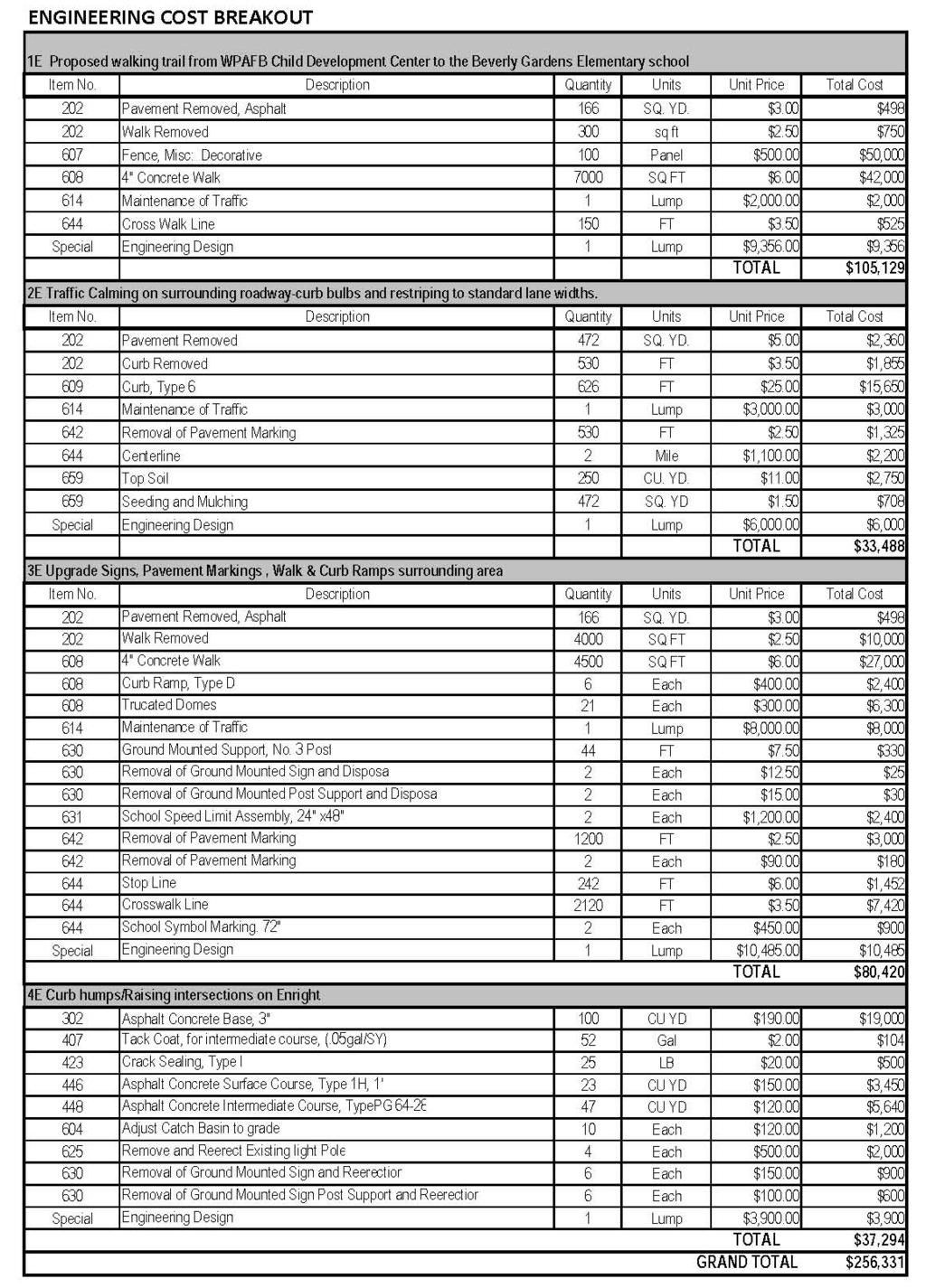
33 The intersection of Spinning Road and Hickam Drive has a signal with pedestrian pushbuttons. There is not pedestrian signing at this intersection. The pedestrian crossing is very wide, making for a long crosswalk. School Policies The Mad River School District should re-evaluate the policy of prohibiting children from riding their bicycles to school if they are below the fourth grade level. SECTION 8: IMPROVEMENTS MAPPING 2E 3E WPAFB Children Development Center Potential Parent Overflow Parking 1E Legend Beverly Gardens Elementary School Beverly Gardens Elementary School Property Line WPAFB Fence Line Proposed Trail connection Proposed Traffic Calming- Curb Bulbs Proposed Traffic Calming- Speed Tables Sign, Pavement Markings, Walk and Curb Ramps Adult Crossing Guard Site of former Beverly Gardens Elementary School. Now ball fields. 3E 4E 3E Proposed Safe Routes to School Engineering Improvement Map 32


34 SECTION 9: THE ACTION PLAN This section will create an action plan from the items listed in the previous section. It will detail a schedule for each item as well as which team member is responsible, when the objective will be completed, and how the activity will be funded. The action plan will create a timeline for implementation and the source of funding for these projects. It will also categorize these improvements as one of the following: Low Cost: $20,000 or below (example: striping, signs, improved curb ramps, education project, encouragement program) Medium Cost: $20,000 to $150,000 (example: new or upgraded signal, enforcement initiative) Hi Cost: $150,000 or above (example: small pedestrian bridge) 33
35 34
36 SECTION 10: THE PLAN ENDORSEMENTS The Beverly Gardens Elementary School Safe Routes to School plan has been reviewed and is approved by the following people who are in a decision-making role and have the authority to speak for either Beverly Gardens Elementary School or the roadways in the City of Riverside, Ohio. Cristi Fields Principal, Beverly Gardens Elementary School Scott Huddle President, Mad River School Board Police Chief Mark Reiss Riverside Police Department Michael Dalton Wright Patterson Air Force Base, Military Housing Bob Murray Director Planning and Economic Development, City of Riverside, Ohio Mitch Miller Director of Public Services, City of Riverside, Ohio Caroline Duffy Traffic Engineering Consultant 35
37 Appendix C Beverly Gardens Parent Survey Summary child has not been killed. I dread picking my child up everyday. If a child gets wet then they stay wet all day. 45. I never want my child walking to or from school. It is too dangerous for children. Child molesters live everywhere! 46. I do not believe that we live in a world that is safe enough for my child to walk/bike to school. 12
MAD RIVER MIDDLE SCHOOL TRAVEL PLAN. City of Riverside, Ohio Ohio Safe Routes to School Plan
 MAD RIVER MIDDLE SCHOOL TRAVEL PLAN City of Riverside, Ohio Ohio Safe Routes to School Plan INDEX SECTION 1: TARGET SCHOOLS AND THE SAFE ROUTES TO SCHOOL TEAM SECTION 2: INTRODUCTION SECTION 3: THE PUBLIC
Rim Rock Elementary School Walking and Biking Audit
 Rim Rock Elementary School Walking and Biking Audit September 29, 2016 Rim Rock Elementary School Audit for Walking and Biking September 29, 2016 Audit Team Members: Sam Atkins, City Engineer, City of
July 5, Arthur R. Ware, Jr. Elementary School 2017 Safe Routes to School Walkabout Report
 July 5, 2017 Arthur R. Ware, Jr. Elementary School 2017 Safe Routes to School Walkabout Report 1 Walkabout Report Introduction On April 28, 2017, City, School, and SAWMPO staff met to conduct a Safe Routes
Safe Routes to School Comprehensive Plan
 Safe Routes to School Comprehensive Plan City of Apple Valley Dakota County, MN May 2010 Prepared by: Project Background The Statewide Health Improvement Program (SHIP) aims to help Minnesotans live longer,
C/CAG. Sunnybrae Elementary School Walking and Bicycling Audit. San Mateo-Foster City School District JUNE 2013
 Sunnybrae Elementary School Walking and Bicycling Audit JUNE 2013 San Mateo-Foster City School District C/CAG City/County Association of Governments of San Mateo County SUNNYBRAE ELEMENTARY SCHOOL WALKING
Vallecito Elementary School. Travel Plan
 Vallecito Elementary School Travel Plan TABLE OF CONTENTS 1. PURPOSE... 1 1.1. SR2S PLANNING, IMPLEMENTATION AND MONITORING... 1 1.2. MARIN COUNTY MEASURE A... 1 2. VALLECITO ELEMENTARY SCHOOL PROFILE...
Wellington Exempted Village School District SAFE ROUTES TO SCHOOL TRAVEL PLAN January 2014
 Wellington Exempted Village School District SAFE ROUTES TO SCHOOL TRAVEL PLAN January 2014 OHIO SAFE ROUTES TO SCHOOL WELLINGTON EXEMPTED VILLAGE SCHOOL DISTRICT TRAVEL PLAN SECTION 1: WELLINGTON EXEMPTED
Bremen Elementary. SAFE ROUTES TO SCHOOL TRAVEL PLAN October 9, 2012
 Bremen Elementary SAFE ROUTES TO SCHOOL TRAVEL PLAN October 9, 2012 Introduction The purpose of the Bremen Elementary Safe Route to School (SRTS) Plan is to encourage school age children to travel to school
About the Studio. Edward J. Bloustein School of Planning and Public Policy - Rutgers University
 About the Studio Edward J. Bloustein School of Planning and Public Policy - Rutgers University Purpose of studio: Help City of Bayonne apply for Safe Routes to School (SRTS) funding by producing a School
SAFE ROUTES TO SCHOOL
 SAFE ROUTES TO SCHOOL Forest Ridge Elementary School Existing Conditions and ACTION PLAN > Oak Creek - Franklin Joint School District Table of Contents CONTEXT Enrollment Boundaries
PROSPECT ELEMENTARY GIRARD INTERMEDIATE GIRARD JUNIOR HIGH
 PROSPECT ELEMENTARY GIRARD INTERMEDIATE GIRARD JUNIOR HIGH SAFE ROUTES TO SCHOOL SCHOOL TRAVEL PLAN January 8, 2014 2 SECTION 1: OUR SCHOOLS School District School Name School Address Grades served Girard
Hidden Oaks Elementary School
 Hidden Oaks Elementary School SCHOOL ROUTE PLAN For HIDDEN OAKS ELEMENTARY SCHOOL LOCATION 13 ORANGE COUNTY Prepared for: ORANGE COUNTY SCHOOL ASSESSMENT PROGRAM ORANGE COUNTY PUBLIC WORKS Traffic Engineering
SAFE ROUTES TO SCHOOL
 SAFE ROUTES TO SCHOOL Edgewood Elementary School Existing Conditions and ACTION PLAN > Oak Creek - Franklin Joint School District Table of Contents CONTEXT Enrollment Boundaries Enrollment
CHILLICOTHE CITY SCHOOLS. SAFE ROUTES TO SCHOOL TRAVEL PLANS for Allen, Mt. Logan, Tiffin & Worthington Elementary Schools January 2013
 CHILLICOTHE CITY SCHOOLS SAFE ROUTES TO SCHOOL TRAVEL PLANS for Allen, Mt. Logan, Tiffin & Worthington Elementary Schools January 2013 i Ohio s Safe Routes to School Travel Plan Template www.dot.state.oh.us/saferoutes
CITY OF OAK CREEK SAFE ROUTES TO SCHOOL ACTION PLAN. East Middle School
 CITY OF OAK CREEK SAFE ROUTES TO SCHOOL ACTION PLAN East Middle School CITY OF OAK CREEK SAFE ROUTES TO SCHOOL ACTION PLAN East Middle School Why Safe Routes to School? Safe Routes to School ( SRTS ) is
Hedgepeth Williams Middle School and Paul Robeson Elementary School Trenton, NJ. School Travel Plan
 Hedgepeth Williams Middle School and Paul Robeson Elementary School Trenton, NJ School Travel Plan Hedgepeth Williams Middle School Description: Hedgepeth-Williams Middle School is located at 301 Gladstone
Chapter 3.3 Horizon Elementary School. Volusia County MPO. June 2009
 Chapter 3.3 Horizon Elementary School Port Orange, FL Volusia County MPO June 2009 Volusia County MPO School Bicycle and Pedestrian Review Study, Phase 3C School Summary Horizon Elementary School is located
ARCADIA ELEMENTARY & MIDDLE SCHOOLS
 ARCADIA ELEMENTARY & MIDDLE SCHOOLS SAFE ROUTES TO SCHOOL TRAVEL August 2013 ARCADIA LOCAL SCHOOLS OHIO SAFE ROUTES TO SCHOOL SCHOOL TRAVEL Ohio Safe Routes to School Travel Plan Local Schools www.dot.state.oh.us/saferoutes
Windy Ridge Elementary School
 Windy Ridge Elementary School SCHOOL ROUTE PLAN For WINDY RIDGE ELEMENTARY SCHOOL LOCATION 54 ORANGE COUNTY Prepared for: ORANGE COUNTY SCHOOL ASSESSMENT PROGRAM ORANGE COUNTY PUBLIC WORKS Traffic Engineering
Lake Whitney Elementary School
 Lake Whitney Elementary School SCHOOL ROUTE PLAN For LAKE WHITNEY ELEMENTARY SCHOOL LOCATION 18 ORANGE COUNTY Prepared for: ORANGE COUNTY SCHOOL ASSESSMENT PROGRAM ORANGE COUNTY PUBLIC WORKS Traffic Engineering
Bringing together community and health. Physical Activity and Nutrition Unit Office of Statewide Health Improvement Initiatives
 Bringing together community and health. Physical Activity and Nutrition Unit Office of Statewide Health Improvement Initiatives Physical Activity and Nutrition Unit Office of Statewide Health Improvement
School Zone Traffic Control Policy
 School Zone Traffic Control Policy I. GE ERAL CITY OF BILLINGS SCHOOL ZONE TRAFFIC CONTROL POLICY (Approved by Traffic Control Board 10/27/99) (Approved by Billings City Council on 6/25/01) This policy
Drag and drop pic and stretch/crop to the limits of the blue rectangle (delete this text box) Maxey Elementary School
 Maxey Elementary School") Drag and drop pic and stretch/crop to the limits of the blue rectangle (delete this text box) Maxey Elementary School SCHOOL ROUTE PLAN For MAXEY ELEMENTARY SCHOOL LOCATION 33 ORANGE COUNTY Prepared for:
Drag and drop pic and stretch/crop to the limits of the blue rectangle (delete this text box) Maxey Elementary School SCHOOL ROUTE PLAN For MAXEY ELEMENTARY SCHOOL LOCATION 33 ORANGE COUNTY Prepared for:
Orange Center Elementary School
 Drag and drop pic and stretch/crop to the limits of the blue rectangle (delete this text box) Orange Center Elementary School Drag and drop pic and stretch/crop to the limits of the blue rectangle (delete
Meadow Woods Elementary School
 Drag and drop pic and stretch/crop to the limits of the blue rectangle (delete this text box) Meadow Woods Elementary School Drag and drop pic and stretch/crop to the limits of the blue rectangle (delete
Parent Survey Report: One School in One Data Collection Period
 Parent Survey Report: One School in One Data Collection Period School Name: Bilquist Elementary School Set ID: 15803 School Group: Clackamas County Month and Year Collected: December 2016 School Enrollment:
Chapter 3.9 Timbercrest Elementary School. Volusia County MPO. November 2008
 Chapter 3.9 Timbercrest Elementary School Deltona, FL Volusia County MPO November 2008 Volusia County MPO School Bicycle and Pedestrian Review Study, Phase 3B School Summary Timbercrest Elementary School
2 Mark Twain Elementary School Report
 2 Mark Twain Elementary School Report Principal: Greg Kaatz Grades: K-2 Enrollment: 323 Address: 425 N. Church Street First bell: 8:10 a.m. Silverton, OR 97381 Last bell: 2:30 p.m. Free & Reduced Lunch:
Monument Elementary School Trenton, NJ School Travel Plan
 Monument Elementary School Trenton, NJ School Travel Plan Prepared by Greater Mercer TMA With Assistance from Alan M. Voorhees Transportation Center; Rutgers, The State University of New Jersey and NJ
THORNVILLE-GLENFORD STP
 THORNVILLE-GLENFORD STP SAFE ROUTES TO SCHOOL TRAVEL PLAN September 2013 OHIO SAFE ROUTES TO SCHOOL SCHOOL TRAVEL PLAN SECTION 1: OUR SCHOOL/S 1A. Identify Target Schools School District School Name School
San Ramon Elementary School. Travel Plan
 San Ramon Elementary School Travel Plan TABLE OF CONTENTS 1. PURPOSE... 1 1.1. SR2S PLANNING, IMPLEMENTATION AND MONITORING... 1 1.2. MARIN COUNTY MEASURE A... 1 2. SAN RAMON ELEMENTARY SCHOOL PROFILE...
Builta Arrival and Dismissal Procedures
 Builta Arrival and Dismissal Procedures The safety of your children/our students is our first concern. The system now in place establishes a pattern for children to arrive and depart safely from Builta.
Lawrence Safe Routes to School. Community Meeting January 14, 2015
 Lawrence Safe Routes to School Community Meeting January 14, 2015 Safe Routes to School The 6 E s Education Encouragement Enforcement Engineering Evaluation Equity What are the elements of a SRTS plan?
REGIONAL BICYCLE AND PEDESTRIAN DESIGN GUIDELINES
 REGIONAL BICYCLE AND PEDESTRIAN DESIGN GUIDELINES November 16, 2011 Deb Humphreys North Central Texas Council of Governments Bicycle and Pedestrian Advisory Committee Snapshot of the Guide 1. Introduction
Improvements Infrastructure Gap Assessment and Improvements Street Striping
 Infrastructure Project Proposal The federal-aid Safe Routes to School program funds infrastructure/engineering projects that fall into two categories: Design (available only to School Development Authority
Safe Routes to School Travel Plan 2011 Reading-Fleming Intermediate School (RFIS)
") Safe Routes to School Travel Plan 0 Reading-Fleming Intermediate School (RFIS) Reading Fleming Intermediate School 50 Court Street Flemington, NJ 088 Grades: 5-6 Introduction Reading-Fleming Intermediate
Safe Routes to School Travel Plan 0 Reading-Fleming Intermediate School (RFIS) Reading Fleming Intermediate School 50 Court Street Flemington, NJ 088 Grades: 5-6 Introduction Reading-Fleming Intermediate
AMHERST EXEMPTED VILLAGE SCHOOLS AND SAINT JOSEPH SCHOOL
 AMHERST EXEMPTED VILLAGE SCHOOLS AND SAINT JOSEPH SCHOOL SAFE ROUTES TO SCHOOL TRAVEL PLAN 12/11/18 DRAFT OHIO SAFE ROUTES TO SCHOOL SCHOOL TRAVEL PLAN Ohio s Safe Routes to School Travel Plan Template
Introduction.
 2307-1.0. Introduction. Delaware s Safe Routes to School (SRTS) Program was established September 10, 2002 when Governor Ruth Ann Minner signed Senate Bill 353 of the 141st General Assembly of Delaware
Grandview Heights Safe Routes to School School Travel Plan Ohio Department of Transportation, District 6 February 23, 2012
 Grandview Heights Safe Routes to School School Travel Plan Ohio Department of Transportation, District 6 February 23, 2012 Grandview Heights School Travel Plan (STP) Safe Routes to School Table of Contents
Parent Survey Report: One School in One Data Collection Period
 Parent Survey Report: One School in One Data Collection Period School Name: Broken Arrow Elementary School Set ID: 12172 School Group: Douglas County Month and Year Collected: October 2014 School Enrollment:
Agenda. Overview PRINCE GEORGE S PLAZA METRO AREA PEDESTRIAN PLAN
 PRINCE GEORGE S PLAZA METRO AREA PEDESTRIAN PLAN May 28, 2008 Agenda Welcome and introductions Project overview and issue identification Planning context and strengths Design challenges and initial recommendations
FREMONT CITY SCHOOLS STP
 FREMONT CITY SCHOOLS STP SAFE ROUTES TO SCHOOL TRAVEL PLAN February 2014 OHIO SAFE ROUTES TO SCHOOL SCHOOL TRAVEL PLAN SECTION 1: OUR SCHOOL(S) 1A. Identify Target Schools School District School Name School
Walkabout Summary Report
 Walkabout Summary Report Introduction On September 3, 2014, stakeholders at Bessie Weller Elementary School (Bessie Weller ES) in Staunton, Virginia met to examine the walking and bicycling network around
SCHOOL ROUTE PLAN. For HUNTER S CREEK ELEMENTARY SCHOOL LOCATION 14 ORANGE COUNTY. Prepared for:
 SCHOOL ROUTE PLAN For HUNTER S CREEK ELEMENTARY SCHOOL LOCATION 14 ORANGE COUNTY Prepared for: ORANGE COUNTY SCHOOL ASSESSMENT PROGRAM ORANGE COUNTY PUBLIC WORKS Traffic Engineering Division 42 South John
Aitkin School Routing Plan July 2010
 Aitkin School Routing Plan July 2010 Prepared by: Arrowhead Regional Development Commission Regional Planning Division Aitkin School Routing Plan July 2010 Aitkin School Routing Plan July 2010 Prepared
Bikeway action plan. Bicycle Friendly Community Workshop March 5, 2007 Rochester, MN
 Bikeway action plan Summary The was held on March 5, 2007 at the Rochester Mayo Civic Center. The workshop was hosted by Rochester-Olmsted County Planning Department in collaboration with the League of
Durrance Elementary School
 Durrance Elementary School SCHOOL ROUTE PLAN For DURRANCE ELEMENTARY SCHOOL LOCATION 9 ORANGE COUNTY Prepared for: ORANGE COUNTY SCHOOL ASSESSMENT PROGRAM ORANGE COUNTY PUBLIC WORKS Traffic Engineering
Caltrans Sloat Boulevard Pedestrian Safety Project Response to Community Questions, Comments & Concerns
 Caltrans Sloat Boulevard Pedestrian Safety Project Response to Community Questions, Comments & Concerns Revised: May 10, 2016 The California Department of Transportation (Caltrans) is planning various
Appendix C. TRAFFIC CALMING PROGRAM TOOLBOX
 Appendix C. TRAFFIC CALMING PROGRAM TOOLBOX PHASE I...2 Do Not Enter Sign...3 One-Way Sign...4 Turn Prohibition...5 Pavement Markings...6 Speed Monitoring Trailer...7 Neighborhood Speed Watch...8 Police
SCHOOL CROSSING PROTECTION CRITERIA
 CITY OF MADISON TRAFFIC ENGINEERING SCHOOL CROSSING PROTECTION CRITERIA January 2016 Adopted as Policy on August 31, 1976, by Common Council by Amended Resolution #29,540 Amended on September 14, 1976,
Doull Elementary School
 Doull Elementary School Safe Routes to School Walking Audit and Recommendations WalkDenver Fall 2013 Doull Elementary School (ECE grade 5) 2520 South Utica Street, Denver 80219 This project was supported
Arlington Public Schools Thomas Jefferson Site Evaluation Transportation Networks. Thomas Jefferson Working Group Meeting #6 November 10, 2014
 Arlington Public Schools Thomas Jefferson Site Evaluation Transportation Networks Thomas Jefferson Working Group Meeting #6 November 10, 2014 2 3 INTRODUCTION 4 Goal of our work: Identify and assess multi-modal
Johnson Elementary School
 Johnson Elementary School Safe Routes to School Walking Audit and Recommendations WalkDenver Fall 2013 Johnson Elementary School 1850 South Irving Street, Denver 80219 This project was supported by Safe
TRAFFIC MANAGEMENT PLAN
 292 84 140440 TRAFFIC MANAGEMENT PLAN The purpose of the Traffic Management Plan (TMP) is to have established procedures for traffic flow and circulation around the elementary school related to student
BEXLEY CITY SCHOOL DISTRICT
 BEXLEY CITY SCHOOL DISTRICT SAFE ROUTES TO SCHOOL TRAVEL PLAN December 2012 OHIO SAFE ROUTES TO SCHOOL SCHOOL TRAVEL PLAN SECTION 1: OUR SCHOOLS 1A. Identify Target Schools School District School Name
Military Road Safety Improvements
 Military Road Safety Improvements 26 th Road North to 31 st Street North SUMMARY OF DATA REVIEW AND PRELIMINARY RECOMMENDATIONS Prepared for: Department of Environmental Services Traffic Engineering and
3 Silverton High School Report
 3 Silverton High School Report Principal: Justin Lieuallen Grades: 9-12 Enrollment: 1,277 Address: 1456 Pine Street First bell: 7:55 a.m. Silverton, OR 97381 Last bell: 3:05 p.m. Free & Reduced Lunch:
Sebastopol Charter School Traffic Management Plan
 Sebastopol Charter School The serves as the working document in support of these essential goals: to ensure the safety and efficiency of student arrival to and departure from school to ensure the safety
Chapter 4.3 Enterprise Elementary. Volusia County MPO. March Page 7.0
 Chapter 4.3 Enterprise Elementary Enterprise, FL Volusia County MPO March 2008 Page 7.0 Volusia County MPO Bicycle and Pedestrian School Safety Review Study Introduction Enterprise Elementary School is
Active Transportation Facility Glossary
 Active Transportation Facility Glossary This document defines different active transportation facilities and suggests appropriate corridor types. Click on a facility type to jump to its definition. Bike
TOWN OF PORTLAND, CONNECTICUT COMPLETE STREETS POLICY
 TOWN OF PORTLAND, CONNECTICUT COMPLETE STREETS POLICY I. VISION, GOALS & PRINCIPLES VISION To improve the streets of Portland making them safer and more accessible for all users including pedestrians,
EXECUTIVE SUMMARY. Vision
 Vision Walking and bicycling in Salt Lake City will be safe, convenient, comfortable, and viable transportation options that connect people to places, foster recreational and economic development opportunities,
TRAFFIC ACTION PLAN. Laurie Meadows Neighborhood CITY OF SAN MATEO
 TRAFFIC ACTION PLAN Laurie Meadows Neighborhood CITY OF SAN MATEO Draft January 2017 Table of Contents Introduction... 2 The Traffic Forum Process... 5 Neighborhood Traffic Issues... 7 Neighborhood Recommendations
Sunset Park Center for Accelerated Studies
 Sunset Park Center for Accelerated Studies The following are a simple list of advantages, disadvantages, and recommendations based on a community assessment. It is not intended to be a list of complete
Traffic Impact Memorandum. May 22, 2018
 BISHOP PROFESSIONAL DEVELOPMENT BUILDING Proposed Land-use Change & Parking Modification 3601 SW 31st Street Topeka, Kansas 66614 CFS Project No. 185077 Traffic Impact Memorandum May 22, 2018 Prepared
Complete Streets. Designing Streets for Everyone. Sarnia
 Complete Streets Designing Streets for Everyone Sarnia Complete Streets ~ Sarnia ~ 2018 Introduction Our City is made up of a network of streets that we use to go for a walk, cycle to work, drive to the
Traffic Circulation & Pedestrian Safety Study
 Lyons Township High School North Campus La Grange, Illinois Parking Lot Vaughan Building N Main Building Prepared for: Prepared by: July 23, 2015 Contents List of Figures, iii 1. Introduction...1 2. Existing
Safe Routes to School Comprehensive Plan
 Safe Routes to School Comprehensive Plan City of Rosemount Dakota County, MN June 2010 Prepared by: Project Background The Statewide Health Improvement Program (SHIP) aims to help Minnesotans live longer,
Appendix T CCMP TRAIL TRAFFIC & TRANSPORTATION DESIGN STANDARD
 Appendix T CCMP 3.3.4 TRAIL TRAFFIC & TRANSPORTATION DESIGN STANDARD 3.3.4 Trail Traffic and Transportation Design Multi-use trails have certain design standards, which vary depending on the agency that
Randolph-Hamline ( Ran-Ham ) Area Safe Routes to School Plan
 Area Safe Routes to School Plan") Randolph-Hamline ( Ran-Ham ) Area Safe Routes to School Plan Cretin Derham Hall Expo Elementary Holy Spirit Elementary Randolph Heights Elementary Saint Paul, Minnesota September 2016 Prepared By: Saint
Randolph-Hamline ( Ran-Ham ) Area Safe Routes to School Plan Cretin Derham Hall Expo Elementary Holy Spirit Elementary Randolph Heights Elementary Saint Paul, Minnesota September 2016 Prepared By: Saint
6.4 RECOMMENDED IMPROVEMENTS
 6.4 RECOMMENDED IMPROVEMENTS 6.4.1 Williston Road Recommendations While all alternatives would be an improvement over existing conditions, Alternative 3B is recommended over the others because it provides
Safe Routes to School Travel Plan 2011
 Safe Routes to School Travel Plan 2011 Barley Sheaf Elementary School Barley Sheaf School 80 Barley Sheaf Road Flemington, NJ 08822 Grades: K-4 Introduction Barley Sheaf School is a K-4 elementary school
Safe Routes to School Action Plan Aberdeen, Idaho
 Background Aberdeen, Idaho is a largely agricultural community of nearly 2,000 people and is located in the southeast portion of the state on the western edge of American Falls Reservoir. The community
APPENDIX A: Complete Streets Checklist DRAFT NOVEMBER 2016
 APPENDIX A: Complete Streets Checklist DRAFT NOVEMBER 2016 Complete Streets Checklist MetroPlan Orlando s Complete Streets Checklist is an internal planning tool for staff to further implementation of
Woodrow Wilson Elementary School Trenton, NJ School Travel Plan
 Woodrow Wilson Elementary School Trenton, NJ School Travel Plan Prepared by Greater Mercer TMA With Assistance from Alan M. Voorhees Transportation Center; Rutgers, The State University of New Jersey and
CONNECTING PEOPLE TO PLACES
 CONNECTING PEOPLE TO PLACES 82 EAST BENCH MASTER PLAN 07 Introduction The East Bench transportation system is a collection of slow moving, treelined residential streets and major arteries that are the
Implementing the Three Es of School Zone Traffic Calming
 Implementing the Three Es of School Zone Traffic Calming Use this evaluation tool as a guide to analyze the specific safety needs of your school. SCHOOL PROFILE School Name: School District: Address: Phone
PRINCE GEORGE S PLAZA METRO AREA PEDESTRIAN PLAN
 PRINCE GEORGE S PLAZA METRO AREA PEDESTRIAN PLAN May 28, 2008 Agenda Welcome and introductions Project overview and issue identification Planning context and strengths Design challenges and initial recommendations
Venetia Valley Elementary School. Travel Plan
 Venetia Valley Elementary School Travel Plan TABLE OF CONTENTS 1. PURPOSE... 1 1.1. SR2S PLANNING, IMPLEMENTATION AND MONITORING... 1 1.2. MARIN COUNTY MEASURE A... 1 2. VENETIA VALLEY ELEMENTARY SCHOOL
The Corporation of the City of Sarnia. School Crossing Guard Warrant Policy
 The Corporation of the City of Sarnia School Crossing Guard Warrant Policy Table of Contents Overview And Description... 2 Role of the School Crossing Guard... 2 Definition of a Designated School Crossing...
MEMORANDUM. Discussion of the planned crosswalk improvement on Mount Vernon Road near Stratham Drive
 MEMORANDUM To: From: Mayor and City Council Michael Smith, Public Works Director Date: August 24, 2015 Subject: Discussion of the Mount Vernon Road Crosswalk Improvement ITEM DESCRIPTION Discussion of
Getting Your SRTS Project Funded. Ryan Snyder
 Getting Your SRTS Project Funded Ryan Snyder Steps in Submitting a Successful Application 1. Stakeholder outreach: create a SRTS coalition 2. Develop a comprehensive plan and program with all 5 Es 3. Conceive
Sardis Elementary School Road Safety Plan. Produced by: Sardis Elementary School - Safer School Travel Team in cooperation with Safer City
 Sardis Elementary Road Safety Plan Produced by: Sardis Elementary - Safer Travel Team in cooperation with Safer City Plan completed in January 2016 1 Acknowledgements It takes commitment and community
LTAC: Katie Mencarini, Central & Hampton Roads streets and a fifteen minute debrief to discuss the findings. Participants walked along Mill Road
 Walkabout Summary On June 3, 2013, five participants met at Glen Allen Elementary School in Glen Allen, Virginia to take a closer look at the walking and biking network around the school. In addition to
TRAFFIC CALMING GUIDE FOR TORONTO CITY OF TORONTO TRANSPORTATION SERVICES DIVISION
 TRAFFIC CALMING GUIDE FOR TORONTO CITY OF TORONTO TRANSPORTATION SERVICES DIVISION CITY OF TORONTO TRANSPORTATION SERVICES DIVISION 2016 TRAFFIC CALMING GUIDE FOR TORONTO TABLE OF CONTENTS Introduction
Memorandum. Public Comments
 711 SE Grand Ave. Portland, OR 97214 (503) 230-9862 www.altaplanning.com Memorandum Date: November 30, 2016 To: From: Re: City of Tacoma Hannah Day-Kapell and Gena Gastaldi, Alta Planning + Design Tacoma
Windom Area Schools District #177 Safe Routes to School Plan Winfair Elementary & the Middle School January 2014
 Windom Area Schools District #177 Safe Routes to School Plan Winfair Elementary & the Middle School January 2014 Prepared by: Southwest Regional Development Commission 2401 Broadway Avenue, Suite 1 Slayton,
ROUNDABOUTS/TRAFFIC CIRCLES
 GENERAL 1. Description This standard identifies minimum requirements that shall be met for Roundabouts and Neighborhood Traffic Circles in the design and construction of elements for Arlington County Horizontal
PEDESTRIAN ACTION PLAN
 ATTACHMENT 2 CITY OF SANTA MONICA PEDESTRIAN ACTION PLAN CITY OF SANTA MONICA PEDESTRIAN ACTION PLAN This page intentionally left blank EXECUTIVE SUMMARY CHAPTER 1 EXECUTIVE SUMMARY Setting the Stage
James Williams Middle School 915 Acacia Lane
 James Williams Middle School 915 Acacia Lane Grades Served: 6 th -8 th Student Geography According to an address analysis of students, 36.7% of students attending JWMS live within 2 miles of school (see
Town of Mooresville, North Carolina Neighborhood Traffic Calming and Control Device Policy
 Town of Mooresville, North Carolina Neighborhood Traffic Calming and Control Device Policy Adopted January 6, 2014 Town of Mooresville Development Services Department TOWN OF MOORESVILLE NEIGHBORHOOD TRAFFIC
Why Zone In on Speed Reduction?
 Learn it. Do it. Live it! SPEED REDUCTION IN THE ZONE Why Zone In on Speed Reduction? Speeding is a serious issue that plays a major role in the risk of serious injury and pedestrian fatality in a crash.
Off-road Trails. Guidance
 Off-road Trails Off-road trails are shared use paths located on an independent alignment that provide two-way travel for people walking, bicycling, and other non-motorized users. Trails specifically along
Safe Routes to School Guide
 Safe Routes to School Guide Steps to Creating a Safe Routes to School Program Created February 2007 SafeRoutes National Center for Safe Routes to School This guide was developed by the Pedestrian and Bicycle
CITY OF KASSON TRANSPORTATION ALTERNATIVES KASSON SAFE ROUTES TO SCHOOL
 ve ha 8t G B A Mantorville Ave N 240th Ave 16th St NE 11th Ave NE K-M HIGH SCHOOL SUNRISE TRAIL TO MANTORVILLE MNTH 57 SUNSET TRAIL TO MANTORVILLE NE PARK 16TH ST NE TRAIL K-M ELEMENTARY SCHOOL K-M MIDDLE
OCEAN DRIVE ELEMENTARY SCHOOL
 OCEAN DRIVE ELEMENTARY SCHOOL North Myrtle Beach, SC Safe Routes to School Travel Plan JANUARY 2017 SRTS Team Roster SRTS Team members represent key community stakeholders, share work of developing the
Appendix A: Crosswalk Policy
 Appendix A: Crosswalk Policy Appendix A: Crosswalk Policy Introduction This citywide Crosswalk Policy is aimed at improving pedestrian safety and enhancing pedestrian mobility by providing a framework
Chapter 3.5 Osteen Elementary School. Volusia County MPO. November 2008
 Chapter 3.5 Osteen Elementary School Osteen, FL Volusia County MPO November 2008 Volusia County MPO School Bicycle and Pedestrian Review Study, Phase 3B School Summary Osteen Elementary School is located
NORTH UNION LOCAL SCHOOLS
 NORTH UNION LOCAL SCHOOLS SAFE ROUTES TO SCHOOL TRAVEL PLAN November 2015 OHIO SAFE ROUTES TO SCHOOL SCHOOL TRAVEL PLAN SECTION 1: OUR SCHOOL(S) 1A. Identify Target Schools School District School Name
ACTIVE TRANSPORTATION
 ACTIVE TRANSPORTATION Mobility 2040 Supported Goals Improve the availability of transportation options for people and goods. Support travel efficiency measures and system enhancements targeted at congestion