Preliminary Exploration of Pedestrian Destinations using Traces from WiFi Infrastructures
|
|
|
- Wendy Ward
- 5 years ago
- Views:
Transcription
1 Preliminary Exploration of Pedestrian Destinations using Traces from WiFi Infrastructures Antonin Danalet, Michel Bierlaire, Bilal Farooq STRC
2 Presentation Outline 1. Motivation 2. Data collections 3. Discriminating destinations from signals 4. Future works 2
3 1. Motivation 3
4 Destinations of pedestrians Input for destination choice analysis Input for route choice analysis Input for pedestrian OD matrix 4
5 Pedestrian data collections Depends on scale and information you re interested in: Dedicated GPS Smartphones Manual counting Single-row laser-range Pedometer Eye-tracking Cameras GSM scanners (LD-A) 5
6 How to measure pedestrian destinations? Cameras Privacy issues Need of a large coverage Smartphones Mode detection Acceptance by the user 6

7 Approach Everybody has a smartphone in the pocket Device-centric Communication infrastructure 7
8 Traces from WiFi infrastructures Available in most campuses, transportation hubs, shopping centers and city centers Mode is mostly walking in these contexts No additional costs required 8
9 Literature Traces from communication infrastructure used with cell towers (Calabrese et al., 2011) With WiFi, destinations are APs or aggregation of APs (Aschenbruck et al., 2011) 9
10 2. Data collections 10
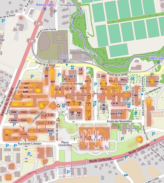
11 EPFL campus Access to WiFi infrastructures Most people on campus are pedestrians Precise map of campus available 11
12 Data collections 2 data collections using WiFi infrastructures at EPFL: 1. Access points data: localization of the AP to which a user is connecting (anonymously for all users) 2. Cisco Context Aware API: triangulation based on signal strength (for 12 known participants) 12

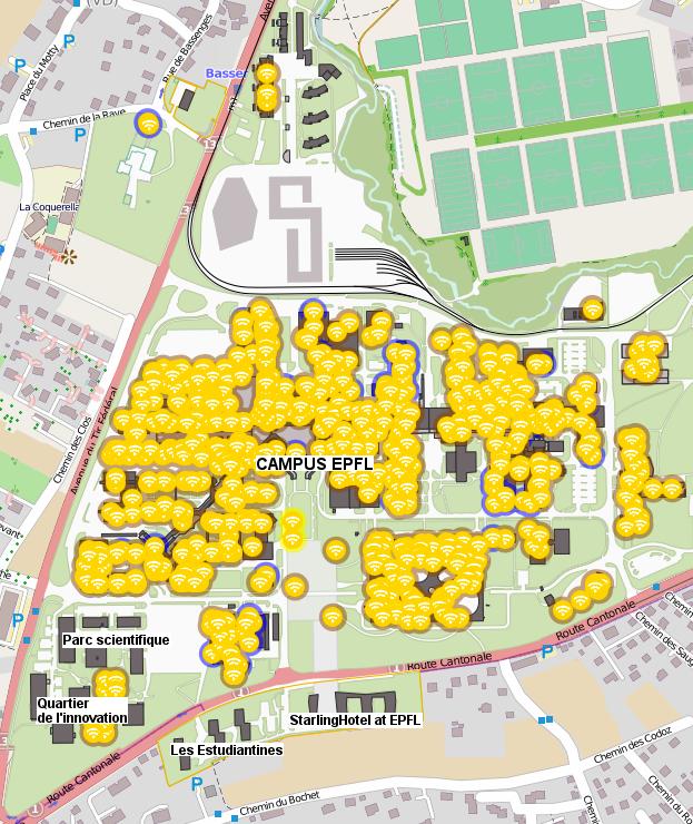
13 789 APs 13

14 14
15 Number of APs by floor Number of APs Floors 15

16 16
17 Video not available in PDF format Please visit: 17

18 18
19 Pedestrian network 4 levels of path (major, inter-, intra-building, access to rooms) edges, vertices public points of interest rooms 19
20 20


21 Points of interest on campus 21
22 Points of interest by floor Total Public Offices Classrooms
23 23
24 24
25 3. Discriminating destinations from signals 25
26 Probabilistic measurement model Goal: Extract possible lists of destinations visited by pedestrians (and their likelihood) using: Traces from WiFi infrastructure Pedestrian network 26
27 Definitions and goal Measurement: State variable: ŝ =(ˆx, ˆt) d =(x, t,t + ) Goal: Associate a likelihood to each list of destinations with arrival and departure times P (ŝ 1,...,ŝ n d 1,...,d n ) 27
28 Generation of x For each signal ŝ, define a domain of data relevance (Bierlaire and Frejinger, 2008) and consider all destinations x in it For AP data: a 50-meter radius circle around each AP For Cisco data: a square with a 95% confidence interval 28
29 Number of points of interest for each signal Number of points of interest Signals (in chronological order) 29
30 Generation of t,t + t i [ˆt i 1 + tt xi 1,x i, ˆt i ] t + i [ˆt i, ˆt i+1 tt xi,x i+1 ] 30
31 position ˆx i+1 ˆx i tt xi 1,x i t t + tt xi,x i+1 ˆx i 1 ˆt ˆt ˆt i 1 i i+1 time 31
32 position ˆx i+1 tt xi 1,x i ˆx i tt xi,x i+1 ˆx i 1 ˆt ˆt ˆt i 1 i i+1 time 32
33 Travel time tt xi,x i+1 = dist(x i,x i+1 ) v Chen, 2012: Speed distribution for pedestrians from smartphone data f(v) =ωλe λv 1 +(1 ω) v 2πτ 2 e (ln v µ) 2 2τ 2 33
34 34
35 Measurement model: P (ˆx x) Friis law for free-space environment: 1 dist(p, ˆp) 2 In case of absorption by obstacles, reflection, scattering, refraction: more complicated. 2 solutions: fingerprinting relate RSS to distance Wang et al. (2003), Cisco: 1 dist(p, ˆp) 3 35
36 Future works Develop the probabilistic model Explore the outcome for route choice Explore the outcome for OD matrix estimation 36
37 Slides and contact information: 37
STRC. Towards an activity-based model for pedestrian facilities. Antonin Danalet Bilal Farooq Michel Bierlaire
 Towards an activity-based model for pedestrian facilities Antonin Danalet Bilal Farooq Michel Bierlaire EPFL STRC April 2013 13th Swiss Transport Research Conference Monte Verità / Ascona, April 24 26,
Estimating a Toronto Pedestrian Route Choice Model using Smartphone GPS Data. Gregory Lue
 Estimating a Toronto Pedestrian Route Choice Model using Smartphone GPS Data Gregory Lue Presentation Outline Introduction Background Data Smartphone Data Alternative Route Generation Choice Model Toronto
Visual Traffic Jam Analysis Based on Trajectory Data
 Visual Traffic Jam Analysis Based on Trajectory Data Zuchao Wang, Min Lu, Xiaoru Yuan, Peking University Junping Zhang, Fudan University Huub van de Wetering, Technische Universiteit Eindhoven Introduction
Review of transportation mode detection approaches based on smartphone data
 STRC 2017-17 th Swiss Transport Research Conference, Ascona Review of transportation mode detection approaches based on smartphone data Marija Nikoli, Michel Bierlaire May 18, 2017 1 / 23 Transportation
#19 MONITORING AND PREDICTING PEDESTRIAN BEHAVIOR USING TRAFFIC CAMERAS
 #19 MONITORING AND PREDICTING PEDESTRIAN BEHAVIOR USING TRAFFIC CAMERAS Final Research Report Luis E. Navarro-Serment, Ph.D. The Robotics Institute Carnegie Mellon University November 25, 2018. Disclaimer
Look Up! Positioning-based Pedestrian Risk Awareness. Shubham Jain
 Look Up! Positioning-based Pedestrian Risk Awareness Shubham Jain Does this look familiar? Pedestrians account for 14% of all traffic fatalities in the US *. In the last decade, 688,000 pedestrians injured
Inferring land use from mobile phone activity
 Inferring land use from mobile phone activity Jameson L. Toole (MIT) Michael Ulm (AIT) Dietmar Bauer (AIT) Marta C. Gonzalez (MIT) UrbComp 2012 Beijing, China 1 The Big Questions Can land use be predicted
NEXT DIRECTION ROUTE CHOICE MODEL FOR CYCLIST USING PANEL DATA
 NEXT DIRECTION ROUTE CHOICE MODEL FOR CYCLIST USING PANEL DATA Melvin Wong, Polytechnique Montréal Bilal Farooq, Polytechnique Montréal Guillaume-Alexandre Bilodeau, Polytechnique Montréal Introduction
Video Analysis for Cyclist Safety: Case Studies in Montreal, Canada
 Video Analysis for Cyclist Safety: Case Studies in Montreal, Canada Bicycle infrastructure design and interplay in traffic OsloTech science park, Oslo Nicolas Saunier (Polytechnique), Sohail Zangenehpour
Mapping Cyclist Activity and Injury Risk in a Network Combining Smartphone GPS Data and Bicycle Counts
 Mapping Cyclist Activity and Injury Risk in a Network Combining Smartphone GPS Data and Bicycle Counts PhD Candidate: Jillian Strauss Supervisors: Luis Miranda-Moreno & Patrick Morency 25th CARSP Conference,
Mobility Detection Using Everyday GSM Traces
 Mobility Detection Using Everyday GSM Traces Timothy Sohn et al Philip Cootey pcootey@wpi.edu (03/22/2011) Mobility Detection High level activity discerned from course Grained GSM Data provides immediate
MWGen: A Mini World Generator
 MWGen: A Mini World Generator Jianqiu Xu and Ralf Hartmut Güting Database Systems for New Applications, Mathematics and Computer Science FernUniversität in Hagen, Germany July, 2012 Outline 1 Problem Description
Application of new information system and technologies to road management & control at ANAS S.p.A.
 November 6th - 8th, 2013 Hotel Panamericano City of Buenos Aires, Argentina URBAN MOBILITY, ROADS NETWORK OPERATION AND ITS APPLICATIONS Application of new information system and technologies to road management
Eric Sundquist Managing Director State Smart Transportation Initiative (SSTI) Urban Sustainability Accelerator
 Urban Sustainability Accelerator") New tools for making better transportation system decisions Eric Sundquist Managing Director State Smart Transportation Initiative (SSTI) Urban Sustainability Accelerator Accessibility and trip-making
New tools for making better transportation system decisions Eric Sundquist Managing Director State Smart Transportation Initiative (SSTI) Urban Sustainability Accelerator Accessibility and trip-making
Kevin Manaugh Department of Geography McGill School of Environment
 Kevin Manaugh Department of Geography McGill School of Environment Outline Why do people use active modes? Physical (Built environment) Factors Psychological Factors Empirical Work Neighbourhood Walkability
Oakville, Ontario Case Study
 Oakville, Ontario Case Study 1 Background The Town of Oakville, a suburb of Toronto, is located on the shore of Lake Ontario and has a population of about 185,000. Oakville created its first Active Transportation
Analysis and modeling of pedestrian flows in railway stations
 SBB-Beirat Technologie, Methoden und Prozesse Analysis and modeling of pedestrian flows in railway stations Flurin Hänseler, Transport and Mobility Lab, EPFL December 4, 2013 1/24 Pedestrian flows in train
Simulation Analysis of Intersection Treatments for Cycle Tracks
 Abstract Simulation Analysis of Intersection Treatments for Cycle Tracks The increased use of cycle tracks also known as protected bike lanes has led to investigations of how to accommodate them at intersections.
A Novel Approach to Evaluate Pedestrian Safety at Unsignalized Crossings using Trajectory Data
 A Novel Approach to Evaluate Pedestrian Safety at Unsignalized Crossings using Trajectory Data Ting Fu Supervisor: Luis Miranda-Moreno, Nicolas Saunier Ting FU Outline 1. Motivation & Literature Review
Figure 2: Principle of GPVS and ILIDS.
 Summary Bubbly flows appear in many industrial applications. In electrochemistry, bubbles emerge on the electrodes in e.g. hydrolysis of water, the production of chloride and as a side-reaction in metal
Traffic Parameter Methods for Surrogate Safety Comparative Study of Three Non-Intrusive Sensor Technologies
 Traffic Parameter Methods for Surrogate Safety Comparative Study of Three Non-Intrusive Sensor Technologies CARSP 2015 Collision Prediction and Prevention Approaches Joshua Stipancic 2/32 Acknowledgements
EXPLORING MOTIVATION AND TOURIST TYPOLOGY: THE CASE OF KOREAN GOLF TOURISTS TRAVELLING IN THE ASIA PACIFIC. Jae Hak Kim
 EXPLORING MOTIVATION AND TOURIST TYPOLOGY: THE CASE OF KOREAN GOLF TOURISTS TRAVELLING IN THE ASIA PACIFIC Jae Hak Kim Thesis submitted for the degree of Doctor of Philosophy at the University of Canberra
Pedestrian Behaviour Modelling
 Pedestrian Behaviour Modelling An Application to Retail Movements using Genetic Algorithm Contents Requirements of pedestrian behaviour models Framework of a new model Test of shortest-path model Urban
SRTS IMPLEMENTATION COSTS
 SRTS IMPLEMENTATION COSTS What Is a Estimate? A cost estimate establishes the anticipated budget required to implement the actions (the improvement projects and programs) identified in your School Travel
Towards City-Scale Smartphone Sensing of Potentially Unsafe Pedestrian Movements
 Towards City-Scale Smartphone Sensing of Potentially Unsafe Pedestrian Movements Trisha Datta Hillsborough Township Public School Hillsborough, NJ, USA tdatta@htps.us Shubham Jain WINLAB, Rutgers University
Aditi Misra Dr. Kari E. Watkins Dr. Christopher A. Le Dantec
 Cycle Atlanta Aditi Misra School of Civil and Environmental Engineering Dr. Kari E. Watkins School of Civil and Environmental Engineering Dr. Christopher A. Le Dantec School Literature, Media, and Communication
The Limassol SUMP Planning for a better future. Apostolos Bizakis Limassol, May 16, th Cyprus Sustainable Mobility and ITS conference
 The Limassol SUMP Planning for a better future Apostolos Bizakis Limassol, May 16, 2017 5 th Cyprus Sustainable Mobility and ITS conference Αbout Limassol Αbout Limassol The second largest city in Cyprus
AutoGait: A Mobile Platform that Accurately Estimates the Distance Walked
 AutoGait: A Mobile Platform that Accurately Estimates the Distance Walked -Written By- Dae-Ki Cho, Min Mun, Uichin Lee, William J. Kaiser, Mario Gerla -Presented By- Scott Mitchell CS Department Problem
Governor s Transportation Vision Panel
 Office of Governor Kate Brown Governor s Transportation Vision Panel JLA Public Involvement Project Overview The is a yearlong effort to develop a series of recommendations for the Governor that address
Pedestrian Activity Criteria. PSAC March 8, 2011
 Pedestrian Activity Criteria PSAC March 8, 2011 Contents 1. Project Overview a) Revised schedule of PSAC hearings 2. Pedestrian Activity: Where walking is important a) Existing conditions (revisions based
Impact of Bike Facilities on Residential Property Prices
 Portland State University PDXScholar TREC Friday Seminar Series Transportation Research and Education Center (TREC) 2-24-2017 Impact of Bike Facilities on Residential Property Prices Wei Shi Portland State
IBI Group November 5, 2012
 IBI Group Agenda Session 1 3:00 PM Welcome / Sign in 3:10 PM Presentation 3:30 PM Questions? 3:35 PM World Café Discussion 4:45 PM Report on top 3 ideas 4:50 PM Next Steps 5:00 PM Adjourn 2 Agenda Session
BUILDING THE BOILERMAKERS BIKING INFRASTRUCTURE
 BUILDING THE BOILERMAKERS BIKING INFRASTRUCTURE March 8, 2017 Michael Gulich Director of Campus Master Planning and Sustainability AGENDA 1. Integrated Bicycle and Pedestrian Infrastructure Plan 2. Purdue
Cycle lane network to connect the different campuses of Technical University of Cartagena (Spain)
") This paper is part of the Proceedings of the 11 International Conference th on Urban Regeneration and Sustainability (SC 2016) www.witconferences.com Cycle lane network to connect the different campuses
This paper is part of the Proceedings of the 11 International Conference th on Urban Regeneration and Sustainability (SC 2016) www.witconferences.com Cycle lane network to connect the different campuses
Module 3 Developing Timing Plans for Efficient Intersection Operations During Moderate Traffic Volume Conditions
 Module 3 Developing Timing Plans for Efficient Intersection Operations During Moderate Traffic Volume Conditions CONTENTS (MODULE 3) Introduction...1 Purpose...1 Goals and Learning Outcomes...1 Organization
UNIVERSITY OF OSLO Department of Physics. Tracking and classification of divers in sonar images. Martin August Brinkmann
 UNIVERSITY OF OSLO Department of Physics Tracking and classification of divers in sonar images Martin August Brinkmann November 8, 2010 Abstract The need for harbor protection systems have increased over
Walk - Run Activity --An S and P Wave Travel Time Simulation ( S minus P Earthquake Location Method)
") Walk - Run Activity --An S and P Wave Travel Time Simulation ( S minus P Earthquake Location Method) L. W. Braile and S. J. Braile (June, 2000) braile@purdue.edu http://web.ics.purdue.edu/~braile Walk
Walk - Run Activity --An S and P Wave Travel Time Simulation ( S minus P Earthquake Location Method) L. W. Braile and S. J. Braile (June, 2000) braile@purdue.edu http://web.ics.purdue.edu/~braile Walk
WMS 8.4 Tutorial Hydraulics and Floodplain Modeling HY-8 Modeling Wizard Learn how to model a culvert using HY-8 and WMS
 v. 8.4 WMS 8.4 Tutorial Hydraulics and Floodplain Modeling HY-8 Modeling Wizard Learn how to model a culvert using HY-8 and WMS Objectives Define a conceptual schematic of the roadway, invert, and downstream
Transportation Planning Division
 Transportation Planning Division Presentation Outline Study Tasks Recap of Previous Meeting Stakeholder Interviews Data Collection Design Principles Tool Box Recommendations Schedule Moving Forward North
WELCOME. Traffic & Parking Commission Special Meeting May 30, Iteris, Inc. All rights reserved.
 WELCOME Traffic & Parking Commission Special Meeting May 30, 2018 WORKSHOP #2 CONCEPTS FOR IMPROVEMENT MAY 30, 2018 Agenda 1. Welcome 10 min 2. Project Presentation 25 min 3. Roundtable Dialogue 50 min
MACROSCOPIC PEDESTRIAN FLOW MODELLING USING SIMULATION TECHNIQUE
 DOI: http://dx.doi.org/10.7708/ijtte.2018.8(2).02 UDC: 711.4:625.88 MACROSCOPIC PEDESTRIAN FLOW MODELLING USING SIMULATION TECHNIQUE Pritikana Das 1, Manoranjan Parida 2, Vinod Kumar Katiyar 3 1 Transportation
Presentation Summary Why Use GIS for Ped Planning? What Tools are Most Useful? How Can They be Applied? Pedestrian GIS Tools What are they good for?
 1 2 Pedestrian GIS Tools What are they good for? Pro Walk / Pro Bike 2006 Presentation Summary Why Use GIS for Ped Planning? What Tools are Most Useful? How Can They be Applied? Matt Haynes Fehr & Peers
Complete Streets: Planning, Policy & Performance
 Complete Streets: Planning, Policy & Performance Tell Us About Your CS Experiences Successes Hardships Funding Politics Safety Not every street needs to be complete, but every mode needs a complete network.
Active Travel and Exposure to Air Pollution: Implications for Transportation and Land Use Planning
 Active Travel and Exposure to Air Pollution: Implications for Transportation and Land Use Planning Steve Hankey School of Public and International Affairs, Virginia Tech, 140 Otey Street, Blacksburg, VA
Reported walking time and measured distances to water sources: Implications for measuring Basic Service
 Reported walking time and measured distances to water sources: Implications for measuring Basic Service Anna Murray1, Maeve Kennard1, Daniele Lantagne2 1, 2Tufts University UNC Water and Health 2018 Background
GIS Based Non-Motorized Transportation Planning APA Ohio Statewide Planning Conference. GIS Assisted Non-Motorized Transportation Planning
 The Purpose of GIS Assisted Network GIS Assisted Non-Motorized Transportation 2011 APA Ohio Statewide Conference Friday, 10:45 AM to Noon Focus on near-term projects wwwgreenwaycollabcom The purpose of
An indoor augmented-reality evacuation system for the Smartphone using personalized Pedometry
 Ahn and Han Human-centric Computing and Information Sciences 2012, 2:18 RESEARCH Open Access An indoor augmented-reality evacuation system for the Smartphone using personalized Pedometry Junho Ahn * and
Plant City Walk-Bike Plan
 Plant City Walk-Bike Plan Plant City Commute Mode Share 2.2% 1.4% 2.9% Drove alone 10.2% Carpooled Public transportation (0.1%) Walked Used a Bike (0.4%) 82.9% Taxicab, motorcycle, or other means Worked
Urban Traffic Analysis Using HSL (Helsinki Bus) Dataset Kai Zhao University of Helsinki
 Dataset Kai Zhao University of Helsinki") Urban Traffic Analysis Using HSL (Helsinki Bus) Dataset Kai Zhao University of Helsinki April 2015 1 Outline Introduction 1. Analyzing Urban Traffic with Network Analysis methods (What, Why). 2. Correlation
Urban Traffic Analysis Using HSL (Helsinki Bus) Dataset Kai Zhao University of Helsinki April 2015 1 Outline Introduction 1. Analyzing Urban Traffic with Network Analysis methods (What, Why). 2. Correlation
Bike Counter Correlation
 Bike Counter Correlation A Story of Synergy: Bike Counts and Strava Metro For decades, transportation planners have used manual and automatic bicycle counters to collect hard data on where and when people
RURAL HIGHWAY SHOULDERS THAT ACCOMMODATE BICYCLE AND PEDESTRIAN USE (TxDOT Project ) June 7, Presented by: Karen Dixon, Ph.D., P.E.
 June 7, Presented by: Karen Dixon, Ph.D., P.E.") RURAL HIGHWAY SHOULDERS THAT ACCOMMODATE BICYCLE AND PEDESTRIAN USE (TxDOT Project 0-6840) June 7, 2016 Presented by: Karen Dixon, Ph.D., P.E., TTI Team: Kay Fitzpatrick, Raul Avelar, & Subasish Das Project
RURAL HIGHWAY SHOULDERS THAT ACCOMMODATE BICYCLE AND PEDESTRIAN USE (TxDOT Project 0-6840) June 7, 2016 Presented by: Karen Dixon, Ph.D., P.E., TTI Team: Kay Fitzpatrick, Raul Avelar, & Subasish Das Project
APPENDIX 4 PEDESTRIAN FACILITY DESIGN INFORMATION
 APPENDIX 4 PEDESTRIAN FACILITY DESIGN INFORMATION 96 EXHIBIT 1 97 EXHIBIT 2 Guidelines for Installing Sidewalks Source: Design and Safety of Pedestrian Facilities, Institute of Transportation Engineers,
Smart Data Role computers play in Technology
 Smart Data Role computers play in Technology October 30 th 2015 Sizzle Video 2016 2 Introduction: Will Phillips INDYCAR Vice President of Technology Daniel Louks INDYCAR Support Engineer Smart Data Role
Pedestrian Mobility in Theme Park Disasters
 1 Pedestrian Mobility in Theme Park Disasters Gürkan Solmaz and Damla Turgut Department of Electrical Engineering and Computer Science University of Central Florida Email: {gsolmaz,turgut}@eecs.ucf.edu
USER GUIDE USER GUIDE
 1 TABLE OF CONTENTS GETTING STARTED 2 Included in the box 2 Compatible smartphones 2 Accessories: 2 Download Mobitee and PIQ application 2 GET STARTED WITH MOBITEE AND PIQ 3 Create your Account and Login
GIS Based Data Collection / Network Planning On a City Scale. Healthy Communities Active Transportation Workshop, Cleveland, Ohio May 10, 2011
 The Purpose of GIS Based Network Planning GIS Based Data Collection / Network Planning Healthy Communities Active Transportation Conference Tuesday, May 10, 2011 10:00 AM Norman Cox, LLA, ASLA. Ann Arbor,
Anniedale- Tynehead NCP Best Practices in Transportation Planning Summary
 Anniedale- Tynehead NCP Best Practices in Transportation Planning Summary The City of Surrey Anniedale-Tynehead NCP Best Practices Transportation Summary This document provides a summary of the Bunt &
Pedestrian Mobility in Theme Park Disasters
 AD HOC AND SENSOR NETWORKS Pedestrian Mobility in Theme Park Disasters Gürkan Solmaz and Damla Turgut The authors are with the University of Central Florida. ABSTRACT Realistic mobility simulation is critical
Gdynia s bicycle model
 Gdynia s bicycle model Problems related to cycling network and demand modelling Michał Miszewski, city of Gdynia Development of tool for transport analysis - MST Statistical data (baseline and forecasts)
Health + Track Mobile Application using Accelerometer and Gyroscope
 Health + Track Mobile Application using Accelerometer and Gyroscope Abhishek S Velankar avelank1@binghamton.edu Tushit Jain tjain3@binghamton.edu Pelin Gullu pgullu1@binghamton.edu ABSTRACT As we live
Measurement of Pedestrian Flow Parameters Case study of Dakor, Gujarat
 Measurement of Pedestrian Flow Parameters Case study of Dakor, Gujarat Chhaya Brahmbhatt 1, Dr. L. B. Zala 2, Dr. Mukti Advani 3 1 IInd Year M.Tech(TSE) Student, Civil Engineering Department, B V M Engineering
City of Novi Non-Motorized Master Plan 2011 Executive Summary
 City of Novi Non-Motorized Master Plan 2011 Executive Summary Prepared by: February 28, 2011 Why Plan? Encouraging healthy, active lifestyles through pathway and sidewalk connectivity has been a focus
EXECUTIVE SUMMARY: TRANSIT-ORIENTED DEVELOPMENT IN SMITHS FALLS, ONTARIO; A COMPARISON BETWEEN TWO SITES
 EECUTIVE SUMMARY: TRANSIT-ORIENTED DEVELOPMENT IN SMITHS FALLS, ONTARIO; A COMPARISON BETWEEN TWO SITES Topic and Purpose In 2007, the Mayor of Ottawa s Task Force on Transportation suggested adding a
Development Type - Neighbourhood Planning and Design
 Introduction The design and layout of new neighbourhoods greatly influences the nature of the urban form. When a neighbourhood is well designed it: allocates land for a range of uses, eg shops, community
The FLOW Approach in Munich. Johannes Keller City of Munich, Department of Urban Planning and Building Regulation
 The FLOW Approach in Munich Johannes Keller City of Munich, Department of Urban Planning and Building Regulation 2 Local FLOW case study: Art Boulevard Arcisstrasse Located in the Munich Art District Result
ROTAX GLOBAL APP GUIDE. (revised ) GRAND FINALS EDITION
 GRAND FINALS EDITION") ROTAX GLOBAL APP GUIDE (revised 16.09.2018) GRAND FINALS EDITION Table of Contents Chap. Content Page Table of Contents 2 Basic Information 3 1. Download Rotax Global App 5 2. Get Internet Connectivity
ROTAX GLOBAL APP GUIDE (revised 16.09.2018) GRAND FINALS EDITION Table of Contents Chap. Content Page Table of Contents 2 Basic Information 3 1. Download Rotax Global App 5 2. Get Internet Connectivity
Modelling Pedestrian Route Choice Behaviour and Its Application to the Planning of Underground Shopping Streets
 Modelling Pedestrian Route Choice Behaviour and Its Application to the Planning of Underground Shopping Streets Hiroshi Tsukaguchi 1, Yuki Ohashi 2 1 Ritsumeikan University, Japan 2 Pacific Consultants
Initial ideas for bus and cycle links
 Initial ideas for bus and cycle links HAVE YOUR SAY The Greater Cambridge City Deal working in partnership: Please complete the survey inside this leaflet or online at: www.gccitydeal.co.uk/a1307 by 1
LOCKOUT STATION FOR TRAINING PURPOSES
 LOCKOUT STATION FOR TRAINING PURPOSES Idea by Patrick Dion Backtender and trainer Windsor Mill LOCKOUT TRAINING THE PROBLEM From the point of view of an operator Lockout activities are not frequent, mostly
Gait Recognition. Yu Liu and Abhishek Verma CONTENTS 16.1 DATASETS Datasets Conclusion 342 References 343
 Chapter 16 Gait Recognition Yu Liu and Abhishek Verma CONTENTS 16.1 Datasets 337 16.2 Conclusion 342 References 343 16.1 DATASETS Gait analysis databases are used in a myriad of fields that include human
WALKABILITY SURVEY IN ASIAN CITIES
 WALKABILITY SURVEY IN ASIAN CITIES This section describes the methodology of the surveys for the benefit of the enumerators (surveyors) with some sample maps for illustration. The methodology for the survey
Cricket umpire assistance and ball tracking system using a single smartphone camera
 1 2 3 4 5 6 7 8 9 10 11 12 13 14 15 16 17 18 19 20 21 22 23 24 25 26 27 28 29 30 31 32 33 34 35 36 37 38 39 Cricket umpire assistance and ball tracking system using a single smartphone camera Udit Arora
Elderly People's Social Support and Walking Space by Space-time Path: A Case Study of Taipei Xinyi District
 International review for spatial planning and sustainable development, Vol.4 No.3 (2016), 4-13 ISSN: 2187-3666 (online) DOI: http://dx.doi.org/10.14246/irspsd.4.3_4 Copyright@SPSD Press from 2010, SPSD
Welcome. Wilmington Transit Moving Forward Workshop Presentation. October 16, 2013
 Welcome Wilmington Transit Moving Forward Workshop Presentation October 16, 2013 Project Purpose Evaluate recommendations from previous studies Wilmington Downtown Circulation Study (WDCS) 2012 State Smart
2014 Fishers Trail Count
 2014 Fishers Trail Count July 2014 Table of Contents Introduction...1 Trail Count Locations...3 Ellipse Parkway at Holland Drive...4 Lantern Road at Sunblest Boulevard...5 126th Street at Cumberland Road...6
Rail Station Fact Sheet UNT Dallas Station
 Rail Station Fact Sheet UNT Dallas Station Station Overview UNT Dallas Station is located on the east side of University Hills Boulevard in Dallas. t is connected by a walking path to the University of
Title: Modeling Crossing Behavior of Drivers and Pedestrians at Uncontrolled Intersections and Mid-block Crossings
 Title: Modeling Crossing Behavior of Drivers and Pedestrians at Uncontrolled Intersections and Mid-block Crossings Objectives The goal of this study is to advance the state of the art in understanding
Utilizing Vessel Based Mobile LiDAR & Bathymetry Survey Techniques for Survey of Four Southern California Breakwaters
 Utilizing Vessel Based Mobile LiDAR & Bathymetry Survey Techniques for Survey of Four Southern California Breakwaters Western Dredging Association: Pacific Chapter September 2012 Insert: Pipe Location
South Florida Commuter Travel Survey Summary and Preliminary Results. Southeast Florida FSUTMS User Group Meeting June 1, 2012
 South Florida Commuter Travel Survey Summary and Preliminary Results Southeast Florida FSUTMS User Group Meeting June 1, 2012 Agenda Introduction Survey Design Survey Implementation Preliminary Findings
1. Sign in personnel, aircraft, and vehicles. Use mission flow chart
 A. PRE-FLIGHT BRIEFING 1. Sign in personnel, aircraft, and vehicles. Use mission flow chart 2. Discuss how the scanner watches for other aircraft during departure, cruise, and approach. 3. Have the trainee
Probing crowd density through smartphones in city-scale mass gatherings
 Wirz et al. EPJ Data Science 2013, 2:5 REGULAR ARTICLE OpenAccess Probing crowd density through smartphones in city-scale mass gatherings Martin Wirz 1*,TobiasFranke 2, Daniel Roggen 1, Eve Mitleton-Kelly
MULTIMODAL INJURY RISK ANALYSIS OF ROAD USERS AT SIGNALIZED AND NON- SIGNALIZED INTERSECTIONS
 MULTIMODAL INJURY RISK ANALYSIS OF ROAD USERS AT SIGNALIZED AND NON- SIGNALIZED INTERSECTIONS PhD Candidate: Jillian Strauss Supervisor: Luis Miranda-Moreno 24th Canadian Multidisciplinary Road Safety
TOWN OF WILLIAMSTON, SC BICYCLE AND PEDESTRIAN MASTER PLAN TOWN OF WILLIAMSTON, SC BICYCLE AND PEDESTRIAN MASTER PLAN
 TOWN OF WILLIAMSTON, SC BICYCLE AND PEDESTRIAN MASTER PLAN Americans Want Choices 55% of Americans would rather drive less & walk more. Transit use is growing faster than population or highway travel.
Spatial Patterns / relationships. Model / Predict
 Human Environment Spatial Patterns / relationships Model / Predict 2 3 4 5 6 Comparing Neighborhoods with high Quality of Life & health Overlap matrix NPUs with high NH & NQoL SEC High QoL High Health
Analysis of Variance. Copyright 2014 Pearson Education, Inc.
 Analysis of Variance 12-1 Learning Outcomes Outcome 1. Understand the basic logic of analysis of variance. Outcome 2. Perform a hypothesis test for a single-factor design using analysis of variance manually
Pedestrian Demand Modeling: Evaluating Pedestrian Risk Exposures
 Pedestrian Demand Modeling: Evaluating Pedestrian Risk Exposures Kelly J. Clifton National Center for Smart Growth University of Maryland May 19, 2008 Study Team University of Maryland National Center
A Walkability Study for Downtown Brunswick
 Alex Thompson and Sam Vitello E.S. 204 Semester Project-Final Paper A Walkability Study for Downtown Brunswick Introduction and Problem Statement The goal of our project was to analyze parking availability
Pedestrian Dynamics: Models of Pedestrian Behaviour
 Pedestrian Dynamics: Models of Pedestrian Behaviour John Ward 19 th January 2006 Contents Macro-scale sketch plan model Micro-scale agent based model for pedestrian movement Development of JPed Results
Winnipeg Walk Bike Projects Downtown Tire Talk - Summary
 Winnipeg Walk Bike Projects Downtown Tire Talk - Summary Downtown Projected Bike Lane System Connecting The Forks to the Exchange District (Fort Street, Garry Street & The Forks to Assiniboine Connection)
AutonoVi-Sim: Modular Autonomous Vehicle Simulation Platform Supporting Diverse Vehicle Models, Sensor Configuration, and Traffic Conditions
 AutonoVi-Sim: Modular Autonomous Vehicle Simulation Platform Supporting Diverse Vehicle Models, Sensor Configuration, and Traffic Conditions Andrew Best, Sahil Narang, Lucas Pasqualin, Daniel Barber, Dinesh
Flow Visualisation Studies - I
 Note DAPPLE - EnFlo xx May, 2004 Flow Visualisation Studies - I Alan Robins, Hong Cheng, Paul Hayden, Tom Lawton EnFlo, Surrey This note presents and discusses some preliminary flow visualisation studies
City of Perth Cycle Plan 2029
 Bicycling Western Australia s response City of Perth Cycle Plan 2029 2012-2021 More People Cycling More Often ABOUT BICYCLING WESTERN AUSTRALIA Bicycling Western Australia is a community based, not-for-profit
Parking. Parking 11/27/2012. On street parking. Off-street parking is space provided for vehicular parking outside the dedicated street right-of-way.
 Parking On street parking Off-street parking is space provided for vehicular parking outside the dedicated street right-of-way. At-grade parking lot Parking garages SITE Parking 90 degree (20 x 9 stalls)
An Intervention to Reduce Distracted Walking
 An Intervention to Reduce Distracted Walking David C. Schwebel, PhD University of Alabama at Birmingham Co-author collaborators: Leslie A. McClure, Bryan Porter Pedestrian Injuries - Background Why the
RESOLUTION NO ?? A RESOLUTION OF THE CITY OF NEPTUNE BEACH ADOPTING A COMPLETE STREETS POLICY
 RESOLUTION NO. 2018-?? A RESOLUTION OF THE CITY OF NEPTUNE BEACH ADOPTING A COMPLETE STREETS POLICY WHEREAS, safe, convenient, and accessible transportation for all users is a priority of the City of Neptune
University of Victoria Campus Cycling Plan Terms of Reference. 1.0 Project Description
 University of Victoria Campus Cycling Plan Terms of Reference 1.0 Project Description The Campus Cycling Plan, a first for the University, will provide a comprehensive and coordinated approach to support
GRISI PLUS Networking Seminar. WRA - Synopsis of Good Practices from an International Perspective
 GRISI PLUS Networking Seminar WRA - Synopsis of Good Practices from an International Perspective Tuesday 13 th November 2012 9.00am-2.00pm Contextual Background of Presentation Reasons for WRA Involvement
Bidirectional Forwarding Detection Routing
 This chapter describes how to configure the ASA to use the Bidirectional Forwarding Detection (BFD) routing protocol. About BFD Routing, page 1 Guidelines for BFD Routing, page 5 Configure BFD, page 5
INTRODUCTION TO PATTERN RECOGNITION
 INTRODUCTION TO PATTERN RECOGNITION 3 Introduction Our ability to recognize a face, to understand spoken words, to read handwritten characters all these abilities belong to the complex processes of pattern
City and County of San Francisco APS Safety & Access Tool. Cover Sheet. Total score = crosswalk worksheet score + intersection worksheet score
 City and County of San Francisco APS Safety & Access Tool Location of Intersection or Crosswalk: Cover Sheet Evaluator Name: Date Evaluation Completed: Total score = crosswalk worksheet score + intersection