MULTI-MODAL TRANSPORTATION BOARD THURSDAY, MARCH 2, :30 PM CITY COMMISSION ROOM 151 MARTIN STREET, BIRMINGHAM
|
|
|
- Gordon Brett King
- 5 years ago
- Views:
Transcription
1 MULTI-MODAL TRANSPORTATION BOARD THURSDAY, MARCH 2, :30 PM CITY COMMISSION ROOM 151 MARTIN STREET, BIRMINGHAM 1. Roll Call 2. Introductions 3. Review of the Agenda 4. Approval of Minutes, Meeting of February 2, Saxon Rd. Improvements Norfolk Dr. to Southfield Rd. 6. Maple Rd. & S. Eton Rd. Crosswalk Improvements 7. Poppleton Ave. Paving - Knox Rd. to Maple Rd. 8. Handicap Parking Policy 9. Meeting Open to the Public for items not on the Agenda 10. Miscellaneous Communications 11. Next Meeting April 6, Adjournment Notice: Due to Building Security, public entrance during non-business hours is through the Police Department Pierce St. Entrance only. Individuals with disabilities requiring assistance to enter the building should request aid via the intercom system at the parking lot entrance gate on Henrietta St. Persons with disabilities that may require assistance for effective participation in this public meeting should contact the City Clerk s Office at the number (248) , or (248) (for the hearing impaired) at least one day before the meeting to request help in mobility, visual, hearing, or other assistance. Las personas con incapacidad que requieren algún tipo de ayuda para la participación en esta sesión pública deben ponerse en contacto con la oficina del escribano de la ciudad en el número (248) o al (248) (para enos un dia antes de la reunión para solicitar ayuda a la movilidad, visual, auditiva, o de otras asistencias. (Title VI of the Civil Rights Act of 1964).
2 DRAFT CITY OF BIRMINGHAM MULTI-MODAL TRANSPORTATION BOARD THURSDAY, FEBRUARY 2, 2016 City Commission Room 151 Martin Street, Birmingham, Michigan Minutes of the regular meeting of the City of Birmingham Multi-Modal Transportation Board held Thursday, February 2, In the absence of both the Chairperson and Vice-Chairperson, it was agreed that Ms. Slanga would take over the chair. Chairperson Johanna Slanga convened the meeting at 6:34 p.m. 1. ROLL CALL Present: Absent: Board Members Lara Edwards, Amy Folberg, Daniel Rontal, Johanna Slanga, Michael Surnow Chairperson Vionna Adams; Vice-Chairperson Andy Lawson Administration: Also Present: Lauren Chapman, Asst. City Planner Jana Ecker, Planning Director Scott Grewe, Operations Commander Paul O'Meara, City Engineer Carole Salutes, Recording Secretary Mike Labadie from Fleis & Vandenbrink ( F&V ),Transportation Engineering Consultants. 2. INTRODUCTIONS Lauren Chapman, Asst. Planner for the City, was introduced. 3. REVIEW AGENDA (no change) 4. APPROVAL OF MINUTES, MEETING OF DECEMBER 1, 2016 Motion by Mr. Surnow Seconded by Mr. Rontal to approve the Minutes of December 1, 2016 as presented.
3 Multi-Modal Transportation Board Proceedings February 2, 2017 Page 2 Motion carried, 5-0. VOICE VOTE Yeas: Surnow, Rontal, Edwards, Folberg, Slanga Nays: None Absent: Adams, Lawson 5. SAXON DR. AND LATHAM RD. Crosswalk Installation Mr. O'Meara recalled that in 2015, the Police Dept. was approached with complaints about traffic volumes and speeds on Saxon Rd., located in the southwest corner of Birmingham. Residents expressed concerns with the amount of traffic as well as the speeds that occur in that area. It is a wide right-of-way, and the street acts as an extension of Fourteen Mile Rd. so it tends to lend itself to speeds faster than the 25 mph speed limit. Saxon Dr. is a border street, with Beverly Hills sharing jurisdiction of this road. Working with representatives from both sides of the street, the City of Birmingham took the lead in discussing the various options with the interested residents. By the middle of 2015, various issues and ideas were explored, and it was decided that the residents would petition the City for a complete road reconstruction. Over 50% of the owners on both sides endorsed the idea, and after receiving an information booklet a neighborhood meeting was held in the summer of After the meeting, enough residents changed their minds, and decided to no longer support the project. Cost was a major factor. Currently, there is no sidewalk connection for pedestrians to cross Saxon Dr., other than at Southfield Rd. The intersection is noted in the Master Plan as a location within Phase 3. It is provided as a suggested improvement, as Latham Rd. is listed as part of a Phase 3 neighborhood connector route. Not only would the improvement help improve the crossing for pedestrians, the pavement markings should help encourage more responsible speeds on Saxon Dr. from motorists passing through the area. The Beverly Hills Village Board has already signed an agreement approving this project, and their commitment to 50% of the cost, based on the cost estimate of about $21,000.. Staff recommends making some storm sewer changes where needed and adding painted crosswalks that would encourage drivers to watch for pedestrians and potentially slow down. If the Multi-Modal Board endorses this project, it will be forwarded to the City Commission for final approval of the funds. The Engineering Dept. will then add it DRAFT
4 Multi-Modal Transportation Board Proceedings February 2, 2017 Page 3 to the 2017 Concrete Sidewalk program contract documents, and oversee the construction of this improvement during the 2017 construction season. Dr.. Rontal did not necessarily think the crosswalk lines would slow cars down. Mr. O'Meara said the residents originally asked for a stop sign but it wasn't warranted by traffic volume. If residents aren t able to help pay for more substantial improvements, this is what can be recommended.. A crosswalk is an attempt to show that cars should slow down for pedestrians at this intersection. Ms. Edwards suggested adding two white lines and a middle yellow dotted line in order to get cars into a more narrow space on Saxon. However, it was noted that at 22 ft. the road is already narrow, and additionally residents have often said a line down the middle would make the road feel like a major street. Mr. O'Meara indicated that the residents felt a crosswalk would help to calm traffic. He noted the Master Plan calls for a crossing improvement at that intersection. Board members were in agreement that installing crosswalks would not slow the traffic and alleviate the residents' concerns. Mr. Labadie did not think painting the road would help too much. As an inexpensive solution he suggested adding a couple of flashing speed limit signs. Commander Grewe said one sign could be budgeted for this stretch of road, but only for westbound traffic. Consensus was to go back to Beverly Hills and the residents and offer at least a speed sign for the westbound traffic and see if that helps. Perhaps Beverly Hills would be willing to split the cost of a speed sign for eastbound traffic. Staff was encouraged to discuss the speed sign, paint markings, etc., with both Beverly Hills and the residents. 6. MAPLE RD. AND S. ETON RD. Crosswalk Improvements Ms. Ecker offered background. The Ad Hoc Rail District Committee was set up by the City Commission to look at a number of issues in the Rail District. They spent a year studying what is going on in that area. Tonight the board will specifically focus on the intersection of Maple Rd. and Eton Rd. The recommendations provide a way to shorten the entire width to cross Eton Rd.. A splitter island in the middle between the right and left turn lanes is suggested along with enhanced crosswalk markings, expanding the sidewalk, and changing the lane configuration. Board members agreed they don't want to encourage people to stand on the splitter island in the middle of Eton Rd.. Ms. Ecker thought that the island calms traffic, and she doesn't imagine too many pedestrians will stand on it because they can get across because of all of the DRAFT
5 Multi-Modal Transportation Board Proceedings February 2, 2017 Page 4 green time on Maple Rd. She likes the idea of dotted lines to direct cars coming off of westbound Maple Rd. and going south on Eton Rd. Commander Grewe said for westbound traffic stopped on the east side of the intersection he would suggest moving the stop line further west so when a vehicle makes a left turn to go south on Eton Rd. the radius isn't so sharp. Mr. Labadie noted the stop bar needs to be located so that drivers can see the signal. Chairperson Slanga cautioned that signage should be placed far enough back so people will know which lane to be in to make their turn. Board members recommended that Mr. Labadie should study this further to ensure large trucks can make a nice clean turn; look at adding dotted lines to show the left track turning radius coming from westbound Maple Rd. south on Eton Rd.; also study moving the westbound Maple Rd. stop bar location and possibly extending the median at that same location. Additionally, study how to accommodate bikes through that intersection. The recommendation from the Ad Hoc Rail District Study Committee was to widen the sidewalks from 5 ft. to 8 ft. on the whole block of Eton Rd. going south. The board was in agreement. 7. MAPLE RD. AND SOUTHFIELD RD. Crosswalk Improvements Mr. O'Meara recounted some safety issues that have occurred over the years at this intersection. In 2015 safety issues at the Maple Rd. & Southfield Rd. intersection were studied by the City's traffic consulting firm, Fleis & Vandenbrink ("F&V"). Lane configuration changes to Maple Rd. were approved, and subsequently put into place in October as a trial, and later approved for permanent status in June, During the studies, it became clear that the crash patterns at this intersection are such that safety could be improved if the intersection was relocated further west, allowing for the creation of a 90 intersection. In 2016, it was determined that the relocation of this intersection may qualify for federal funding. Further, it was decided that since Maple Rd. is planned for reconstruction further east (in downtown), if safety funding was awarded, it would be an appropriate time to address both areas within the same construction project. The City directed F&V to apply for federal funding for this potential safety improvement. The application is currently pending, and should be announced in May of In December, Commissioner DeWeese expressed concerns about the crosswalk that appear similar to those that have been raised in the past. The speed of northbound right turning vehicles continues to be an issue. The matter was referred to F&V in preparation for a review by the MMTB. Since a major change will require significant spending, and since a federal funding application is currently pending, F&V suggested a change in DRAFT
6 Multi-Modal Transportation Board Proceedings February 2, 2017 Page 5 signing as a possible small step while awaiting the status of the intersection. The suggested newer signage should alert drivers better than the current sign. Ms. Folberg suggested changing the signal so that pedestrians cannot cross when people are allowed to turn right. Also, the "WATCH FOR PEDESTRIANS" sign blocks the view of pedestrians. He was not in favor of creating delays that would back up traffic. Motion by Ms. Edwards Seconded by Ms. Folberg to direct staff to change the existing WATCH FOR PEDESTRIANS WHILE TURNING at the Maple Rd. and Southfield Rd. intersection to updated R10-15 signs (TURNING VEHICLES YIELD TO PEDESTRIANS) for eastbound Maple Rd. and northbound Southfield Rd. Reposition the new sign so it does not block the view of pedestrians. Also, add reflector material around the sign so it will stand out. Motion carried, 5-0. VOICE VOTE Yeas: Edwards, Folberg, Rontal, Slanga, Surnow Nays: None Absent: Adams, Lawson 8. CROSSWALK STANDARDS UPDATE Mr. O'Meara recalled the MMTB discussed the above topic three times in A suggested recommendation was agreed to at the meeting of November 2, 2016, and forwarded to the City Commission for approval at their meeting of November 21, After discussing the matter, the Commission referred it back to the MMTB for further study. The comments from the commissioners can be summarized as follows: Definitions for various road types and conditions need to be very clear so that the outcome is clear. The suggested variance for spacing between the bars was too great. Information about how much the City pays to maintain crosswalks was requested. The use of 24 in. wide bars (instead of 12 in.) was preferred. It was noted that other cities such as Royal Oak and Ferndale are making more use of the 24 in. bars. Mr. O'Meara said it is important to note that if 24 in. wide bars become the standard, generally existing painted markings will remain as-is until the pavement in the intersection is being replaced ore resurfaced.,. Moving to a 24 in. wide bar as the standard in all locations would translate into a slow, gradual increase as crosswalk markings are removed and replaced. DRAFT
7 Multi-Modal Transportation Board Proceedings February 2, 2017 Page 6 Since the Commission (and some MMTB members) prefer the 24 in. wide painted bars, and since increased costs are not significant, the new standard recommends the use of 24 in. wide bars at all new crosswalk locations. Spacing is also suggested at 24 in. wide, similar to what is being done in other local jurisdictions. The width of the walking surface remains an area that needs to be adjusted depending on the local street conditions. The National Assoc. of City Transportation Officials ("NACTO") suggests that the crosswalk width should be as wide or wider than the adjacent sidewalks so that groups of pedestrians can comfortably pass each other in the provided area. With the above standards in mind, a guideline is provided for total crosswalk width. It was discussed that 24 in. space between the bars can only be adjusted slightly. Motion by Dr. Rontal Seconded by Ms. Edwards to recommend that the City Commission adopt the following standard policy for the design of all future crosswalk pavement markings in the City of Birmingham, as recommended by the Multi-Modal Transportation Board: All new painted crosswalks installed shall be of the continental style, as outlined on MDOT Detail Sheet PAVE-945-C, Sheet 3 of 3, with the exception that all painted bars shall be 24 in. wide spaced as close to 24 in. apart as possible. Crosswalk widths shall be installed as follows: On Major Streets within the Central Business District, Triangle District, Rail District, or Adjacent to Schools: Total width of the crosswalk shall be 12 to 14 feet wide. Crosswalks at the upper width limit may be installed when traffic signals are present. On Local Streets within the Central Business District, Triangle District, Rail District, or Adjacent to Schools: Total width of the crosswalk shall be 8 ft. wide, unless the adjacent sidewalk main walking path is wider, at which point it shall be widened to match the main walking path width. At All Other Locations: Total width of the crosswalk shall be 6 ft. wide. The following shall be considered Major Streets (within the specific districts noted) for the purposes of this standard: Woodward Ave. DRAFT
8 Multi-Modal Transportation Board Proceedings February 2, 2017 Page 7 Old Woodward Ave. Maple Rd. Southfield Rd. Adams Rd. Willits St. Oakland Blvd. Chester St. Brown St. S. Eton Rd. E. Lincoln Ave. Motion carried, 5-0. VOICE VOTE Yeas: Rontal, Edwards, Folberg, Slanga, Surnow Nays: None Absent: Adams, Lawson 9. MEETING OPEN TO THE PUBLIC FOR ITEMS NOT ON THE AGENDA (no audience present) 10. MISCELLANEOUS COMMUNICATIONS Ms. Ecker said an update will be provided to the board at the next meeting as to what materials will be used on Old Woodward Ave., the turn lane, and what the crosswalks will look like. 11. NEXT MEETING MARCH 2, 2017 at 6 p.m. 12. ADJOURNMENT No further business being evident, the board members adjourned the meeting at 8:10 p.m. Jana Ecker, Planning Director DRAFT Paul O'Meara, City Engineer
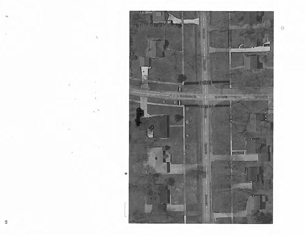
9 MEMORANDUM DATE: February 24, 2017 Engineering Dept. TO: FROM: SUBJECT: Multi-Modal Transportation Board Paul T. O Meara, City Engineer Saxon Rd. Improvements Norfolk Rd. to Southfield Rd. At the February Multi-Modal Transportation Board (MMTB) meeting, the City presented a proposal to install a marked, improved crosswalk at the intersection of Saxon Dr. and Latham Dr./Norchester Rd. The proposal was precipitated for two main reasons: 1. Staff worked previously with residents on this segment of Saxon Dr. to potentially install improvements that would reduce traffic speeds and volumes on this road. More significant changes could not be implemented due to disagreements from residents relative to costs. A downsized improvement, one that could be funded both by the City and the adjacent Village of Beverly Hills, was suggested as a possible partial improvement to address their concerns. 2. The crosswalk was a featured recommendation within Phase III of the Multi-Modal Master Plan. In December, the Beverly Hills Village Council officially agreed to commit to 50% of the crosswalk improvement. When the idea was reviewed by the MMTB, the following questions and concerns were raised: 1. Board members were not convinced that the crosswalk improvement would make much difference in addressing the issue of traffic speeds and volumes. 2. Board members felt that two other ideas had more merit: a. Permanent speed indicator signs for both directions. b. Pavement markings, consisting of a skip or double yellow down the middle, and white edge lines throughout the corridor. Staff initiated conversations with the two neighborhood representatives for Saxon Rd. relative to these ideas, as well as further talks with the Police Dept. The following responses came back: 1. Neither resident supported the idea of installing linear pavement markings. 2. Both residents support the crosswalk improvement as presented by staff. 3. One resident supported the speed indicator sign, while the other was neutral if a resident was willing to have it installed in front of their house. 4. Both residents asked that a 25 pavement marking legend be installed west of Southfield Rd. to encourage residents to slow down. 1
10 5. One resident wished to explore other more extensive ideas such as refuge islands, gateway structures, or speed humps. Based on these responses, we have the following information to offer: 1. We do not recommend moving forward with linear pavement markings. 2. Staff will continue to support the crosswalk improvement, and ask that the MMTB reconsider this idea. 3. The Police Dept. has offered to pursue the installation of a speed indicator sign for westbound traffic, if a suitable location can be found. Funds for a new sign will be available in the new fiscal year starting July 1, Previous attempts to install the sign failed because the locations considered suitable by the Police Dept. were not endorsed by the immediate residents. We have a call out to Beverly Hills staff to get an update on where they stand with a similar sign for eastbound traffic, which will be reported at the meeting. 4. Assuming the Board has no objection, staff will proceed with getting a 25 pavement marking legend installed for westbound traffic, west of Southfield Rd., as weather permits. Neighborhood representatives have been invited to the meeting. Hopefully a dialogue with them can be had to bring this matter to a close. The following recommendation is provided, but can be modified as needed based on information determined next week at the meeting: SUGGESTED RECOMMENDATION: To recommend to the City Commission the approval of the following improvements for Saxon Dr. : 1. The installation of crosswalks on the east and west sides of the Latham Dr./Norchester Rd. intersection, including pavement markings, to be funded 50% by the City of Birmingham, and 50% by the Village of Beverly Hills. 2. The installation of an electronic speed indicator sign for westbound traffic, west of Southfield Rd., pending the location of a suitable location, by the City of Birmingham, and 3. The installation of a 25 pavement marking legend for westbound traffic, west of Southfield Rd., by the City of Birmingham. 2
11 MEMORANDUM DATE: January 24, 2017 Engineering Dept. TO: FROM: SUBJECT: Multi-Modal Transportation Board Paul T. O Meara, City Engineer Saxon Rd. & Latham Rd. Crosswalk Installation In 2015, the Police Dept. was approached with complaints about traffic volumes and speeds on Saxon Rd., located in the southwest corner of Birmingham. Residents expressed concerns that the wide right-of-way, the straight nature of the street, and the fact that this street acts as an extension of 14 Mile Rd. all helped create an environment that is less desirable to the adjacent residents. Various ideas were provided, such as: - Complete reconstruction of the road to install a defined edge with curb and gutter. - Roundabout at the Latham intersection. - Speed hump installation. - Crosswalk improvements the Latham intersection. - Electronic speed indicator installation. Saxon Rd. is a border street, with Beverly Hills sharing jurisdiction of this road. Working with at least one representative from both sides of the street, the City of Birmingham took the lead in discussing these various options with the interested residents. By the middle of 2015, various issues with the above ideas were explored, and it was decided that the residents would petition the City for a complete road reconstruction. (New pavement installation on an unimproved road requires the creation of a special assessment district, wherein the majority of the cost is paid by the adjacent property owners.) Since two jurisdictions were involved, signatures endorsing this idea were collected on two separate petitions. Once petitions were received indicating that over 50% of the owners on both sides endorsed the idea, our office prepared an informational booklet and mailed it to all parties on both sides of the street. A neighborhood meeting was also held in the summer of After the meeting, enough residents changed their minds, and decided to no longer support the project. Cost was a major factor. Since the road paving project was not going to proceed, our office offered a much smaller, more affordable improvement that could be shared with Beverly Hills, and charged to each jurisdiction s general funds. That is the topic of this report. Currently, there is no sidewalk connection for pedestrians to cross Saxon Dr., other than at Southfield Rd. The intersection is noted in the Master Plan as a location within Phase 3. It is provided as a suggested improvement as Latham Rd. is listed as part of a Phase 3 neighborhood connector route. Not only would the improvement help improve the crossing for pedestrians, the pavement markings should help encourage more responsible speeds on Saxon Dr. from motorists passing through the area. 1
12 Attached for your information are the following: 1. References to the suggested improvement in the Multi-Modal Master Plan. 2. Aerial Plan of the intersection, with new sidewalks and pavement markings added in black. 3. Cost Estimate (total) to be paid 50% by Birmingham, 50% by Beverly Hills. 4. Photos of the intersection looking in all four directions. Since the right-of-way is wider than average, it could be considered deficient in its current state. There is also open ditch drainage on both sides of the street, making the installation of sidewalks more involved than usual. Additional cost for storm sewer and imported fill is reflected in the estimate above. The Beverly Hills Village Board has already signed an agreement agreeing to this project, and their commitment to 50% of the cost, based on the cost estimate provided above. If the Multi- Modal Board endorses this project, it will be forwarded to the City Commission for final approval of the funds. The Engineering Dept. will then add it to the 2017 Concrete Sidewalk program contract documents, and oversee the construction of this improvement during the 2017 construction season. A suggested recommendation is provided below. SUGGESTED RECOMMENDATION: To endorse the installation of crosswalks at the Saxon Dr. and Latham Rd. intersection, in accordance with the Multi-Modal Master Plan, to consist of storm drainage and fill improvements, concrete sidewalks, and pavement markings as shown on the attached plan. 2
13 127 CITY OF BIRMINGHAM MULTIMODAL TRANSPORTATION PLAN NETWORK IMPLEMENTATION PLAN 4.4 PHASE 3 PHASE 3: OVERVIEW This phase focuses on completing the multi-modal network and includes the remaining network improvements. Due to the length of time it is going to take to complete the first two phases, the remaining improvements have been grouped into Phase 3. When the first two phases are near completion, a more thorough evaluation should be done to determine what new opportunities are available and what the costs may be. The following pages outline the remaining infrastructure improvements to complete the multimodal network. FIGURE 4.3A. PHASE 3 Page

14 129 PHASE 3: RECOMMENDED ROAD CROSSING IMPROVEMENTS Many of the remaining road crossing improvements align with the neighborhood connector routes, provide mid-block crossings and increase visibility between motorists and pedestrians in the downtown. Page
15 130 DRAFT- October 14, 2013 PHASE 3: RECOMMENDED NEIGHBORHOOD CONNECTOR ROUTES This phase focuses on completing the neighborhood connector routes. While the neighborhood connector routes are relatively easy and economical to implement some are dependent on the construction of proposed pathways and road crossing improvements. It will be important to prioritize the implementation of the neighborhood connector routes in this phase based on the progress of pathways implementation and road crossing improvements. Page

16


17

18 1/24/ Norchester St - Google Maps Norchester St Saxon & Norchester, Looking North Beverly Hills, Michigan Street View - Jun 2012 Image capture: Jun Google 1/1

19 1/24/ Saxon Dr - Google Maps 1180 Saxon Dr Saxon Dr. & Latham Rd. - Looking West Birmingham, Michigan Street View - Sep 2012 Image capture: Sep Google 1/1


20 1/24/ Latham St - Google Maps 1974 Latham St Saxon Dr. & Latham Rd. Intersection - Looking South Birmingham, Michigan Street View - Sep 2012 Image capture: Sep Google 1/1

21 1/24/ Saxon Dr - Google Maps 1218 Saxon Dr Saxon Dr. & Latham Dr., Looking East Birmingham, Michigan Street View - Sep 2012 Image capture: Sep Google 1/1
22 MEMORANDUM DATE: February 24, 2017 Engineering Dept. TO: FROM: SUBJECT: Multi-Modal Transportation Board Paul T. O Meara, City Engineer Maple Rd. & S. Eton Rd. Improvements As you know, the Ad Hoc Rail District Committee finished its work, and submitted a report of recommendations to the City Commission in December, The attached report dated January 27, 2017, summarizing suggested improvements at the Maple Rd. was reviewed by the Multi-Modal Transportation Board at its meeting of February 2, At that time, the following comments were raised: 1. There was concern that the island may not permit left turns from Maple Rd. on to southbound S. Eton Rd. Various ways to correct that were discussed, such as moving the westbound Maple Rd. stop bar west, or extending the island at the center pillar of the railroad bridge. 2. Provide a cost estimate for narrowing the street to allow for a wider sidewalk on the west side of the block. 3. Consider again how bikes may be accommodated in this area. Staff worked with F&V to consider these items, and offers the following responses: 1. F&V considered truck turns in this area when it designed the island several months ago. The attached drawing depicts the turning radius for a 50 ft. semi-truck trailer to make the left turn from Maple Rd. on to southbound S. Eton Rd. The island allows for the turning movement. Also shown on this drawing is how right turns are also accommodated for these large trucks from S. Eton Rd. on to eastbound Maple Rd. No adjustments are needed to the island design. The other ideas that were expressed, such as moving the westbound stop bar, or extending the island at the center pillar, are not recommended. 2. In order to widen west side sidewalk from Maple Rd. to Yosemite Blvd., three feet of S. Eton Rd. must be removed, a new curb section must be installed, and then a new eight foot wide sidewalk can be installed in place of the existing five foot wide sidewalk. The total cost for this portion of the work is estimated at $53,000. The total cost of the three improvement areas now being considered are: Splitter island $20,000 Landscaping at island $ 1,000 Widened handicap ramp area at SE corner $ 1,000 Widened sidewalk and ramps on W side $53,000 TOTAL $75,000 1
23 3. Both N. Eton Rd. & S. Eton Rd. have been part of a marked bike route for decades. It is also part of the new Neighborhood Connector route that has been approved by the City Commission, and is planned to be installed this spring. The Maple Rd. intersection, and the two blocks of Eton Rd. north and south of the intersection have always been a poor segment in the route for bicyclists. The railroad bridge conflict at this intersection is significant, and remains a multi-million dollar problem that will not be easy to fix. Further, when Eton Rd. was impacted by the railroad in 1930, a small 50 ft. right-of-way was left for these short diagonal sections, to make room for the railroad. In order to process the large traffic demand on S. Eton Rd. at the Maple Rd. intersection, a minimum of three lanes must be provided, with two northbound storage lanes to queue while waiting to enter Maple Rd. in both directions. Once three lanes are provided, as well as sidewalks on both sides, there is no extra right-of-way left. (That is why the sidewalks are constructed immediately behind the curb on both sides of the street.) The only extra space available on the street is currently in the southbound lane, which is now being suggested for removal, to widen the west side sidewalk. While this proposal improves the pedestrian environment, it will compromise the bicyclist experience. The MMTB may wish to consider if the $53,000 suggested improvement on the west side of S. Eton Rd. is wise when it is in fact leaving no extra space for southbound bicyclists on this Neighborhood Connector Route. No funding is currently being provided in the current or upcoming budget for these improvements. A suggested recommendation at this time can then be moved forward to the City Commission in time for them to consider an adjustment to the recommended fiscal year budget: SUGGESTED RECOMMENDATION: To recommend to the City Commission that the City prioritize the Ad Hoc Rail District Committee s recommendations for changes to S. Eton Rd. from Maple Rd. to Yosemite Blvd. including: 1. Landscaped splitter island to improve the S. Eton Rd. south side crosswalk at Maple Rd. 2. Enlarged handicap ramp area at the southeast corner of the intersection. 3. Relocation of the west side curb and gutter section to allow for a widened eight foot sidewalk on the entire length from Maple Rd. to Yosemite Blvd. 2

24
25 MEMORANDUM Planning & Engineering Department DATE: January 27, 2017 TO: FROM: SUBJECT: Multi-Modal Transportation Board Paul T. O Meara, City Engineer Brooks Cowan, Planning Intern Intersection Improvements at Maple Rd. & S. Eton Rd. On January 9, 2017, the City Commission reviewed and endorsed the final recommendations of the Ad Hoc Rail District Committee. The final report, as presented to the Commission, is attached, as well as the minutes from that meeting. Today s report focuses on the recommendation to install pedestrian improvements for the intersection of Maple Rd. and S. Eton Rd. In the spring of 2016, the committee conducted a walking audit of the area and deemed this intersection unsafe for people who wish to cross the street. The committee found it difficult to traverse the 88 foot wide intersection within the allotted crossing time. It was determined that actions should be taken to shorten the walkable distance between the east and west part of the intersection, possibly installing a refuge island in the middle, and improving the pavement markings to increase driver awareness of pedestrian crossing areas. A concept drawing has been provided by Fleis and Vandenbrink that encourages pedestrian friendly changes for the intersection. A splitter island is proposed between the right turn and left turn lanes on northbound Eton. This is meant to provide refuge for pedestrians who cannot cross the 88 ft wide intersection within the allotted signal time. Stop bars for the left and right turn lanes on northbound Eton would be relocated closer to Maple, adjacent to the splitter island. Widening the sidewalks on both sides from 5 to 8 is also proposed at this intersection. Doing so effectively reduces the crosswalk distance at Eton, provides more space and safety for sidewalk users, and narrows the adjacent driving lanes which may reduce travel speeds. Additional continental striping to increase driver awareness of the pedestrian crossing is proposed as well. Please see attached image below for designs. An engineering analysis of each follows. 1
26 2
27 The south leg of this intersection (S. Eton Rd.) was reconstructed in A part of the engineering plan sheet for this project is attached to this report, for reference. PEDESTRIAN SPLITTER ISLAND Construction of the splitter island is feasible at this time, provided funds are budgeted. The existing concrete could be sawcut and removed, and new concrete curbs and sidewalk could be installed. The excess space south of the island could be landscaped with perennial plantings to be maintained by the Dept. of Public Services. Only plantings that can handle the difficult conditions would be recommended (salt in winter, lack of water in summer). Other traffic islands are now being maintained by City staff in a similar manner. The cost of this improvement is estimated at $10,000. WIDENED SIDEWALK, WEST SIDE As shown on the attached 2009 construction plan, there is no additional right-of-way on the southwest corner of this intersection. The Multi-Modal Master Plan suggests a widened 8 ft. wide sidewalk (up from the present 5 ft.). There is no room to do this in the direction away from the road without first purchasing right-of-way, and constructing a retaining wall to hold back the existing hill. This may prove to be a difficult venture. A second alternative, as suggested by the report, is to narrow the southbound lane of S. Eton Rd. by three feet, reconstructing the curb. This would provide new space for a widened sidewalk for this area. To maintain positive drainage, the majority of the existing sidewalk would have to be removed as well. It is important to consider that this is the only designated truck route into the Rail District commercial area. Since the splitter island would already be narrowing the intersection, and making left turns from Maple Rd. to S. Eton Rd. will be more difficult, it is recommended that the island be installed first. Actual conditions can then be monitored to see if the road narrowing on the west side is an appropriate future measure. WIDENED SIDEWALK, EAST SIDE The Ad Hoc Rail District plan suggested widening the existing sidewalk on Maple Rd. from the Eton Rd. ramp to the railroad bridge. However, right-of-way is again a problem. A widened sidewalk could be installed in the arc area of the walk directly south of the SE corner handicap ramp. Adding sidewalk here would not require removal of any existing concrete, and would be a simple improvement valued at about $1,000. As a first step toward improving pedestrian conditions at this intersection, it is recommended that $11,000 be added to the fiscal year budget, within the Sidewalk Fund, to pay for the installation of a landscaped splitter island and widened sidewalk at the southeast corner of the intersection of Maple Rd. and S. Eton Rd. 3
28 SUGGESTED RECOMMENDATION To recommend to the City Commission that $11,000 be budgeted within the Sidewalk Fund for pedestrian crossing improvements at the intersection of Maple Rd. and S. Eton Rd. Funding would allow the installation of a landscaped splitter island and widened sidewalk at the southeast corner of the intersection. 4

29

30 1/27/ E Maple Rd - Google Maps 2000 E Maple Rd Maple Rd. & S. Eton Rd. Looking South Birmingham, Michigan Street View - Oct 2016 Image capture: Oct Google 1/1

31 1/27/ S Eton St - Google Maps 139 S Eton St Maple Rd. and S. Eton Rd., Looking NE Birmingham, Michigan Street View - Aug 2015 Image capture: Aug Google 1/1
32 Mr. Manda agreed that it is design criteria and priorities and the process involves putting those in order and evaluating. If having a medium to large size trucks in the downtown is not a desirable criteria, that will have an impact on the intersections, curves and details. Mayor Nickita commented that we are very close. There are some subtleties to the midblock crossings. He confirmed with Mr. Manda that the width of the crossing on Maple is 10 feet. It may be too close to Old Woodward. He said that is another priority criteria issue. Surely, parking is a priority, but also designing a pedestrian crossing in the most appropriate way is a very important priority. He thinks we have to minimize the parking loss by doing it at the via and not at the Social crossing. We can explore options on how to address a couple of medians in the way we discussed achieving the goals. Mayor Pro Tem Harris recognized we are on a tight timeline, and wondered if an additional iteration will affect the timeline. City Manager Valentine said we are very tight on the timeline, and as we move forward, that will push things back. It would be an additional two weeks before the next meeting. Mr. Manda said that is enough time to revise and bring back. Mayor Nickita said it is very important to do this as well as we can. Mayor Nickita clarified the items discussed which include diminishing the width of midblock crosswalks to maximize parking wherever that is possible, and some of the options for the medians in two locations. The only other median we did not discuss is the alley located by Pierce. He suggested designing something there that would be similar to the other median designs, perhaps smaller and with a rolling curb. Mr. Manda said that is a very narrow alley. Mayor Nickita suggested that we might consider recommending a traffic pattern question on whether that is done one way or the other. He suggested looking at the use at that alley to determine if there is another option FINAL REPORT OF THE AD HOC RAIL DISTRICT REVIEW COMMITTEE City Planner Ecker provided background and history of the Ad Hoc Rail District Review Committee established by the City Commission on January 11, 2016, to study existing and future conditions and to develop a recommended plan to address parking, planning and multimodal issues in the Rail District and along S. Eton Road ( the Rail Plan ). Over the past eight months, the Ad Hoc Rail District Review Committee has worked to identify issues in the Rail District and along S. Eton, and to develop a plan with recommendations to address parking, planning and multi-modal issues in the Rail District, as directed by the City Commission. The Ad Hoc Rail District Review Committee requested funds to hire a consultant to review some of the intersection design concepts discussed by the Committee, and to conduct an analysis of parking in the study area. Based on the Committee s direction, the findings outlined in the consultant s report, and the input of the public, a draft of the Ad Hoc Rail District Report requested by the City Commission has been prepared. On December 5, 2016, the Ad Hoc Rail District Review Committee held their final meeting to review and approve their final report. After much discussion, the Ad Hoc Rail District Review Committee voted to recommend approval of the final report to the City Commission, with minor changes. All of the requested changes have been made. 7 December 12, 2016
33 Ms. Ecker introduced Sean Campbell, Assistant Planner and Brooks Cowen, Planning Intern who provided assistance with the GIS analysis of parking and intersection design. Ms. Ecker explained the goals and objectives of the committee which included: Goals: To create an attractive and desirable streetscape that creates a walkable environment that is compatible with the adjacent residential neighborhoods. To design the public right-of-way for the safety, comfort, convenience, and enjoyment for all modes of transportation throughout the corridor. To facilitate vehicular traffic and parking without sacrificing the corridor s cycling and pedestrian experience. To minimize the impacts of traffic on the existing residential neighborhoods. To recommend updates to the Rail District zoning regulations as needed to meet goals. Objectives: To use creative planning to promote a high quality, cohesive right-of-way that is compatible with the existing uses in the corridor. To implement traffic calming techniques, where appropriate, to reduce speeds and discourage cut-through traffic on residential streets. To enhance pedestrian connectivity through the addition of crosswalks, sidewalks, and curb extensions. To improve accommodations for bicycle infrastructure on Eton Road. To create a balance between multimodal accessibility and parking provisions. Ms. Ecker said the concerns were apparent during the tour. Key areas identified were S. Eton and Maple. Discussion included widening the sidewalk on the west side of the street for a bigger safety zone for pedestrians. Widening the sidewalk on the east side of S. Eton was also suggested to create a bigger plaza area there as well. They also discussed adding a splitter island to give a pedestrian island in the middle for people walking across. Several intersections up and down S. Eton were also looked at and the need for additional bump outs, and better striping. The intersection at S. Eton and Bowers was felt to be an important area with a great deal of activity. Bump outs and using different accent material in that area to create a plaza feel which would remind vehicles to slow down in the area. Ms. Ecker noted a parking inventory and study were conducted. The study revealed there are 2,480 parking spaces in the district as a whole. There are 941 on-street parking spaces, 1539 parking spaces on individual private properties. The north end of the district has more a need for parking at different times. The south end is busier during the working day, but it clears out at 5:00 PM. It was noted that the entire west side of S. Eton was never at full capacity. The highest use was around Griffin Claw with 28 out 60 spaces that were full on a Friday night. Ms. Ecker discussed future build-outs and how they reached some of the conclusions. She explained that the issue became clear because they have to self-park, maximum build-out will not be done, and the biggest issue is that there is no shared parking in the area. That keeps the development down to roughly 26-30% of what could be done under the ordinance. Many of the parcels in the focus area do not have enough space to provide required parking for 8 December 12, 2016
34 four stories of retail and residential uses unless they build an underground parking facility. Based on recent development trends in the area, this is unlikely to occur and thus, buildout rates will likely remain in the 20-30% range of maximum build-out, requiring less than 1,070 additional parking spaces in the study area. It is important to note that based on the current standards, all of these additional parking spaces must be provided by individual property owners and/or developers. Thus, the City need only focus on encouraging an efficient use of private parking facilities, and ensuring good right-of-way design to accommodate additional vehicle traffic and balance the needs of non-motorized users. The provision of additional public parking is not warranted now, nor in the near future. The recommendations of the committee include: Construct bump-out curbs throughout the study area; Install a splitter island at the crosswalk at S. Eton and Maple, widen the sidewalk on the west side of S. Eton, restripe S. Eton to realign lanes, and add enhanced crosswalk markings; Add sharrows and buffers to S. Eton from Yosemite to 14 Mile. Maintain sharrows and accommodate parking south of Lincoln where possible. Encourage shared parking in the district by providing the zoning incentives for properties and/or businesses that record a shared parking agreement. Incentives could include parking reductions, setback reductions, height bonuses, landscape credits, or similar offers; Install gateway signage at the north and south ends of the study area and install wayfinding signage throughout the Rail District to direct people to destinations and parking. Mayor Nickita commended the committee on the depth and problem solving that was undertaken. Commissioner Bordman said the study was so thorough. She was very impressed that the committee was able to figure out the real parking needs. Mayor Pro Tem Harris questioned what incentives there might be for shared parking. Ms. Ecker said perhaps landscaping requirements could be relaxed, but we would ask the Planning Board to study that in more detail. Commissioner DeWeese noted there might be an economic incentive. Commissioner Hoff asked about the southeast corner of S. Eton and Maple intersection and if the property is city property. She also asked if the Whole Foods operation was studied by the committee. Commissioner Hoff expressed concern that traffic on S. Eton will be increased. The committee s concern was with the speed of the traffic. Mayor Pro Tem Harris asked why the committee did not recommend a dedicated bike lane. Ms. Ecker said there were a couple of issues including the bump out incompatibility as well as the pavement material issue. Commissioner DeWeese noted that we can accept the report and use it for a general guideline. City Manager Valentine confirmed that any recommendation will be brought back to the Commission for consideration. Mayor Nickita asked if this addressed the edge condition that has been an issue and do we need to include something in the Zoning Ordinance. Ms. Ecker said it was not discussed in 9 December 12, 2016
35 detail. She said currently there is a regulation in the ordinance that does not allow parking in the first twenty feet of depth. Mayor Nickita said this helps bring attention to a very under-utilized area of the city, and land owners do not realize that they are sitting on potential redevelopment value if they work together at shared parking for example. MOTION: Motion by Sherman, seconded by Bordman: To accept the final report of the Ad Hoc Rail District Review Committee, and forward same to the Multi-Modal Transportation Board for their consideration in finalizing the design of the S. Eton corridor, and to the Planning Board, and direct the Planning Board to add Recommendations 4 (Encourage Shared Parking) and 5 (Add Wayfinding Signage) from the final report to their Action List for further study, and to develop a way to implement the shared parking, and to correct the crosswalk marking within the final report as discussed. Larry Bertollini expressed concern about the recommended options, and focusing on both sides of Maple and S. Eton, and visibility concerns. Mayor Nickita suggested going forward to study with and without parking on both sides, and how it may affect speed. We know people tend to speed up when parking is removed on one side. VOTE: Yeas, 7 Nays, None Absent, None MONTHLY PARKING PERMIT RATE INCREASES City Engineer O Meara explained that monthly permit rates at the structures have been adjusted on several occasions over the years, usually to reflect the difference in demand at the various parking structures. Recently, increases at all five structures were implemented in the summer of 2014, and again in As demand for parking spaces grew, increases were considered justified not only because of high demand, but also to help build a savings account in the parking system fund for potential upcoming construction. In April of this year, staff reviewed the rates with the Advisory Parking Committee (APC), and recommended a package of increases that would primarily impact both the monthly and daily rates in the parking structures. Raising the lower priced meters so that all meters were $1 per hour was also suggested. Other changes were included as well, designed to reduce demand in the parking structures, and to encourage employees to consider the City s off-site parking options. The APC was not inclined to recommend any changes at that meeting. Staff refined the package based on APC input, and also provided options on how to charge the daily rate. At the May meeting, the APC approved a recommendation that included several items, with the two significant changes impacting the monthly and daily rates in the structures. The suggested increase for most of the lower cost parking meters was not agreed to. At the June 6, 2016 Commission meeting, the recommendations of the APC were discussed. Most of the package was approved that evening including the daily rate at the structures. The monthly rate structure was not changed at that time, and the City Commission asked at the time to consider being more aggressive. 10 December 12, 2016

36 Ad Hoc Rail District Report November 28, 2016
37 Table of Contents Executive Summary 3 Ad Hoc Rail District Committee. Goals and Objectives... Study Area.. Review of Existing Plans Zoning Analysis.. Preliminary Assessment. Conceptual Improvements Existing Parking.. 17 Build-out Analysis.. 20 Recommendations. 28


38 Executive Summary Executive Summary The Ad Hoc Rail District Committee was tasked with conducting research and analysis regarding parking, street design initiatives, and non-motorized safety to develop a plan with recommendations for the future of the Rail District along S. Eton. The Committee conducted a walking survey to assess the existing conditions of the Rail District. During this exercise, crosswalks issues, poor driver visibility at street corners, inconsistent sidewalks, and lack of bicycle facilities were noted. Based on the Committee s observations, several intersection and streetscape improvements were reviewed, a parking study was completed to review current parking demand, and a buildout analysis was conducted to calculate future parking needs. The Ad Hoc Rail District Committee s resulting findings include recommendations for intersection improvements to calm traffic and improve pedestrian comfort, exploring shared parking opportunities to more efficiently use off-street parking lots, and adding bicycle facilities to better accommodate bicyclists. Newingham Dental Completed 2014 District Lofts Phase 2 Completed 2016 IrgonGate Completed in
39 Ad Hoc Rail District Committee Formation of the Committee On January 11, 2016, the City Commission unanimously passed a resolution to establish the Ad Hoc Rail District Committee. The Committee was tasked with developing a plan to address the current and future parking demands, along with planning goals and multi-modal opportunities for the district in accordance with the following: a) Review the Eton Road Corridor Plan, Multi-Modal Transportation Plan, and previous findings of the Rail District Committee in order to identify and recommend how to best incorporate these elements into an integrated approach for this district. b) Calculate the long-term parking demands for both the north and south ends of the Rail District, while considering on-street and off-street parking, shared parking arrangements, use requirements and other zoning regulations which impact parking. c) Review planning and multi-modal objectives for the Rail District with the findings from the long-term parking calculations and develop recommendations to integrate planning and multi-modal elements with parking solutions. Recommendations should consider: i. Considerations for on-street and off-street parking ii. Road design initiatives iii. Multi-modal uses iv. Neighborhood input v. Existing plans and findings Goals and Objectives of Committee The following goals and objectives were established by the Ad Hoc Rail District Committee to guide their discussions and recommendations for the future: Goals i. Create an attractive and desirable streetscape that creates a walkable environment that is compatible with the adjacent residential neighborhoods. ii. Design the public right-of-way for the safety, comfort, convenience, and enjoyment for all modes of transportation throughout the corridor. iii. Facilitate vehicular traffic and parking without sacrificing the corridor s cycling and pedestrian experience. iv. Minimize the impacts of traffic on the existing residential neighborhoods. v. Recommend updates to the Rail District zoning regulations as needed to meet goals. Objectives i. Use creative planning to promote a high quality, cohesive right-of-way that is compatible with the existing uses in the corridor. ii. Implement traffic calming techniques, where appropriate, to reduce speeds and discourage cut-through traffic on residential streets. iii. Enhance pedestrian connectivity through the addition of crosswalks, sidewalks, and curb extensions. iv. Improve accommodations for bicycle infrastructure on Eton Road. v. Create a balance between multimodal accessibility and parking provisions. d) Compile the committee s findings and recommendations into a single report to be presented to the City Commission by the end of the committee s term (December 31, 2016). 4

40 Study Area Rail District Study Area 5

41 Review of Existing Plans Eton Road Corridor Plan (1999) Vision Statement: The Eton Road Corridor will be a mixed use corridor with a range of commercial, service, light industrial and residential uses that serve the needs of the residents of Birmingham. Creative site planning will be encouraged to promote high quality, cohesive development that is compatible with the existing uses in the corridor and adjacent single-family residential neighborhoods. Much of the success that can be observed in the District today is owed to the recommendations contained in the Eton Road Corridor Plan (ERCP). Many of the recommendations have been implemented including the eastward extension of Villa and Hazel into the northern end of the District, the creation of the MX zoning classification, associated development regulations, and the addition of streetscape requirements. However, many recommendations contained in the ERCP have not been fully implemented that specifically impact the circulation of vehicular, pedestrian, and bicycle traffic. These recommendations are as follows: A series of curb extensions and chokers at select intersections to create better visibility for pedestrians and to encourage lower speeds for motorists; To accommodate at least one protected bike lane, given that S. Eton is an important link in a regional bike system; and To discourage front parking and to place commercial and residential buildings closer to the road. 6


42 Review of Existing Plans Multimodal Transportation Plan (2013) Vision Statement: The City of Birmingham seeks to build upon its brand as a walkable community. The purpose of this plan is to provide a document that the Community may reference when contemplating future actions regarding infrastructure, policies and programs. It is envisioned that this plan will guide improvements designed to give people additional transportation choices, thereby enhancing the quality of life in the City of Birmingham. Less than 3 years since its adoption, implementation of the Multimodal Transportation Plan ( MMTP ) is already well underway. Many areas identified in the plan that have not yet been retrofitted are at least at the forefront of multimodal discussion in the city. The Eton Road Corridor has proven to be one of those areas. As demonstrated in the MMTP, there is an expressed community desire for a transportation network that adequately responds to the needs of various users and trip types. In order to achieve this vision for the Rail District, the MMTP recommends the following physical improvements: Completing sidewalks along Cole St.; Installing curb extensions on S. Eton Rd. at Yosemite, Villa, Bowers, Holland, and Cole; Improving crossing areas at Villa, Bowers, Holland and Cole; and Striping bike lanes on S. Eton via parking consolidation: shared lane markings from E. Maple to Villa; buffered bike lane and shared lane markings from Villa to E. Lincoln. 7
 Encourage and direct development within the boundaries of the Eton Road Mixed-Use District and implement the Eton Road Corridor Plan; b)")
43 Zoning Analysis Zoning Analysis The majority of the S. Eton Corridor was zoned MX Mixed-Use, in accordance with the recommendation of the ERCP. The MX District was established with the intent to: a) Encourage and direct development within the boundaries of the Eton Road Mixed-Use District and implement the Eton Road Corridor Plan; b) Encourage residential and nonresidential uses that are compatible in scale within adjacent resident neighborhoods; c) Encourage the retention, improvement, and expansions of existing uses that help define the Eton Road Corridor; d) Allow mixed use developments including residential uses within the Eton Road Corridor; and e) Minimize the adverse effects of nonresidential traffic on the adjacent residential neighborhood. With zero foot minimum front and side yard setback requirements, no required open space, and buildings permitted up to 4 stories in height, the MX District encourages a midrise, integrated urban form throughout the Corridor. However, a majority of the buildings in the district have not been developed to the new standards set forth in the current Zoning Ordinance. Many properties still contain single-use, one-story buildings that do not maximize their potential space. The buildings that have been recently constructed are emblematic of the District s goal of creating appealing mixed-use buildings that complement the adjacent residential neighborhoods. The District Lofts, for example, demonstrate the potential of the District development standards with its wellfenestrated façades that abut the front and side lot lines, ground floor retail space and residential upper floors, and its sufficient parking facilities. A fundamental goal of the Rail District is to minimize the adverse effects of nonresidential traffic on the adjacent neighborhood, but the current road design does little to provide a buffer between the MX and residential zones. Traffic, parking, and safety issues still persist to this day. Actions are recommended for Eton Rd that ease the transition from the residential neighborhood to the mixed use zone and provide safe access to the area s amenities for all modes of transportation. 8
44 Preliminary Assessment Preliminary Assessment: Public Perception and Identification of Issues Committee members reviewed and analyzed existing conditions in the Rail District. Discussion branched off into five main topics: Rail District Design and Development, Pedestrian Safety/Amenities, Parking, Traffic, and Bicycles. The committee s comments have been summarized into bullet points below. Rail District Design & Development The committee members are pleased with new developments in the district. The development standards for the new buildings have created an overall appealing look. Parking in front of the older buildings is not favorable in the context of creating a more pedestrianized corridor. The Committee raised the point about how the Rail District ends at Lincoln. Members discussed extending the project area towards 14 Mile as the stretch south of Eton serves as a vital connection. The width of S. Eton is viewed as problematic, as it encourages cars to exceed the speed limit. Bump-out curbs are needed on S. Eton at necessary intersections between E. Maple and Sheffield as a way to narrow down the road, slow traffic, and make it easier to cross the street. This would create safer access to the parks, pool, and other amenities. The Committee proposed reviewing zoning uses and standards for the rail district. The recent improvements to W. Maple are also something the Committee wants to keep in mind as a good example when making recommendations for the Rail District. Pedestrian Safety/Amenities 3 The Committee is displeased with the lack of pedestrian safety in the Rail District. Committee members emphasized the importance of safe and adequate pedestrian crossing throughout the District, especially along S. Eton Rd. The idea is to have a complete network of sidewalks and crossings that encourage people to walk through the District. The intersection at S. Eton and Maple is not amenable to pedestrians, especially when they are attempting to get from S. Eton to N. Eton. The intersection at S. Eton and Cole, especially on the commercial side, is not safe from a pedestrian or vehicle standpoint. Parking Parking was raised as a priority. The committee would like to see an evaluation of parking demand with respect to supply, and how to resolve the issue via structures, surface lots, and on-street locations. Parking along S. Eton, especially the southbound (west) side, was identified as a key focus of the committee. It was also mentioned that on street parking may not need to extend to 14 Mile. On-street parking spaces on S. Eton are seen as a problem as they inhibit the visibility of drivers and pedestrians and make it difficult for residents to back out of their driveways. Visibility should be considered in future parking studies. Excessive speed heading southbound on S. Eton especially from 14 Mile to Lincoln was identified as an issue to be addressed moving forward. More emphasis should be placed on non-motorized transportation in the study area. More specifically, S. Eton should be designed to be safer for bicyclists. Traffic The Committee is concerned with the cut-through traffic that occurs on S. Eton The new Whole Foods is expected to increase the amount of traffic through the corridor, so the City should consider street designs that regulate speed and traffic, while ensuring a safe pedestrian experience. Bicycles The bike route transition from N. Eton to S. Eton should be improved; however, a continuous bike lane may not be a feasible means by which to do this. The committee would like the southwest corner of E. Maple and S. Eton to be widened in order to improve bicycle and pedestrian safety and to ease traffic flowing in and out. 9


45 Preliminary Assessment Preliminary Assessment: Walking Survey Committee members conducted a walking survey and inventory of the S. Eton Corridor. Findings are outlined below and on the pages that follow. First stop - under the bridge at S. Eton/Maple Rd. Viaduct has a bunker feel Not a good corner to cross Widening the sidewalk would help calm traffic Bump-out/plaza at corner would be effective, but difficult A pedestrian island would help at this intersection Second stop - Yosemite/S. Eton Drivers are not fully aware of pedestrians around this stretch of S. Eton A crosswalk is needed here Bump-out curbs may be necessary A bike lane could start around here The street begins to narrow down closer to beauty shop Bump-out and bike lane might contradict each other Third stop Villa/S. Eton Possible bump-out curbs here Visibility is very obstructed at this corner Fourth stop Hazel/S. Eton A crosswalk is needed at the Whistle Stop A crosswalk would help slow traffic S. Eton improvements must be consistent Fifth stop - Bowers/S. Eton This is area is a destination and should receive a large crossing with different treatment, such as a plaza in the center This stop does not warrant a stop sign, but controls should be built to calm traffic speed People who come to eat at Griffin Claw don t know where to park
 Sixth stop Haynes/S.")


46 Preliminary Assessment Preliminary Assessment: Walking Survey (Continued) Sixth stop Haynes/S. Eton It was noted that parking could occur along the dividing island at Bolyard Lumber Seventh stop Holland/S. Eton A double crosswalk exists here but it is not a natural crossing spot Eighth stop Webster/S. Eton Curbs are terrible here Bump-out curbs are suggested for this location Yellow no parking lines may be too long next to driveways Ninth stop Cole/S. Eton Bump-outs are recommended on the four corners Many interesting shops to the east Tenth stop Lincoln/S. Eton This is a prominent corner There should be something that demarcates commercial from residential Well defined crosswalks here Future streetscape improvements should be considered
 14 13 14 th stop Commerce/Cole A sidewalk in")


47 Preliminary Assessment Preliminary Assesment: Walking Survey (Continued) th stop Commerce/Cole A sidewalk in front of school property was suggested There are large parking lots to the north and east behind the Cole Business Center 13 th stop Commerce/Lincoln An industrial area with several underutilized surface lots 12 th stop Lincoln looking East Public parking on south side of Lincoln 11 th stop Melton/S. Eton This is a wide intersection, but not a four-way stop Vehicles can turn easily here so they go fast There is parking on only the west side of Eton Need for traffic calming

 16 15 th stop Commerce and Cole")


48 Preliminary Assessment Preliminary Assessment: Walking Survey (Continued) th stop Cole Business Center Lots There is much parking to the north and east behind Cole Business Center with underutilized parking Two adjoining parking lots are blocked from each other by a wall (no shared access) th stop Commerce and Cole Sidewalks needed in front of the school property Several surface parking lots in front of buildings that are not full th stop Northbound S. Eton Yellow curbing was noted in front of Down River Refrigeration Angled parking was not supported at this location by Multi Modal Transportation Board Sidewalk is incomplete in front of Roy Schecter and Vocht office No sidewalk connection from S. Eton to Robot Garage area th stop DPS/Down River Refrigeration Sparse parking around Down River Refrigeration 13


49 Conceptual Improvements Concepts Considered Within Study Area Based on the issues identified in the preliminary assessment of the study area and a review of the ERCP and MMTP, the Committee considered numerous improvements for the right of way at specific locations. S. Eton and Maple Intersection Existing Proposed Existing Proposed Design Concept 2 Another option at this location could be to create a bump-out to give motorists better visibility of pedestrians attempting to cross and to shorten the length of road crossings for pedestrians. Design Concept 1 At the southeast corner of S. Eton and Maple, there is a lot of activity but very little room to work with to make any drastic changes. As suggested during the walking tour, the pavement at this corner could be extended into the grass area to provide a more comfortable pedestrian space. 14


50 Conceptual Improvements Existing Proposed Design Concept 3 The Committee discussed constructing a pork chopshaped pedestrian island as an alternative to a bumpout. A pedestrian refuge could effectively channel drivers to slow down and gives pedestrians the ability to wait on it instead of having to rush across the street during a short traffic light interval. The committee recommended hiring a consultant to evaluate traffic calming measures and pedestrian improvements at this complex intersection. Existing Proposed S. Eton and Yosemite Intersection Bump-out curbs were considered for the intersection of S. Eton and Yosemite and could be coupled with striped crosswalks for additional safety. Having a bump-out at this intersection would help demarcate between the commercial area and residential area. Additional bump out curbs and crosswalk improvements were also suggested along S. Eton at Villa Road, Hazel St, Webster St., and Cole St. 15


 Following the recommendation of the MMTP, the Committee discussed the option of adding bicycle facilities to S.")
51 Conceptual Improvements S. Eton and Bowers Intersection Committee members recognized this area as being of significant importance as it marks the approximate center of the Rail District. Brick pavers could be used to accent the intersection with color to remind people that it is a place for both pedestrians and cars. As shown in the suggested rendering, the concept is coupled with curb bump outs, benches, and on-street bike racks, as well as pedestrian crosswalk improvements to create a plaza condition. Existing Proposed The committee recommended hiring a consultant to study possible improvements to this intersection. S. Eton Corridor (Maple to Lincoln) Following the recommendation of the MMTP, the Committee discussed the option of adding bicycle facilities to S. Eton by adding sharrows for northbound bicycle traffic, eliminating parking on the west side (also recommended by the MMTP), and giving southbound traffic a 10 foot protected bike lane that includes a 3 foot buffer zone. Existing Proposed 16

52 Existing Parking Parking Inventory and Study Figure 1 A Parking inventory was completed in the study area for a better understanding of when and where parking spaces are being utilized. A map of total spaces was created for private lots and on street parking. The results are illustrated in Figure 1, and show an existing parking count of 2,480 spaces in the study area and surrounding neighborhood. A parking study was also completed to determine parking utilization in the study area. Parking counts were conducted by city staff at 4, 5, and 6pm on Friday September 23rd and Wednesday September 30th, and the data was then analyzed. Current Total Parking On Street: 941 Off Street: 1539 Total: 2480 The consulting firm Fleis and Vandenbrink was contracted to create a report for the count studies and provide summary tables showing available spaces, occupied spaces, and percent occupancy rate for the north and south zones of the study area. An analysis and conclusion based upon the findings was then made for off street and on street parking situations in each of the zones. Count data was then entered into a map for each day and time of the study. The maps on the following pages indicate the total counts for each hour of on street and off street parking spaces, and color code the percent occupancy rate in classes for 0, 1-33%, 34-66%, and %. These maps are shown side by side to visually illustrate the intensities of parking in the district, and how the parking occupancy rates change from 4-6pm in the study area. 17

53 Existing Parking Friday Parking Count: 4:00 PM Friday Parking Count: 5:00 PM Friday Parking Count: 6:00 PM S. Eton Rd - 9 out of 60 spaces on the west side are used - 16 out of 63 spaces on the east side are used Off Street Parking - Parking lots off of Cole Street at or near capacity - Griffin Claw already above 66% capacity Residential Parking - Yosemite and Villa experience overflow throughout the evening. - Villa stays between 33-66% occupancy rate throughout the Friday study. S. Eton Rd - 16 out of 60 spaces on the west side are used - 21 out of 63 spaces on the east side are used Off Street Parking - The lots off of Cole Street begin to clear out - Two of the parcels above 66% are auto repair shops with outdoor vehicle storage. S. Eton Rd - 26 out of 60 spaces on the west side are used - 30 out of 63 spaces on the east side are used *the highest occupancy throughout the study - 0 spaces on west side, south of Holland are used the entire evening Off Street Parking - Griffin Claw parking lot reaches capacity. - Only 2 of 11 spaces are used in Whistle Stop. - 0 spaces are used outside of Bolyard Lumber. - Robot Garage/Watch Hill lot never exceeds 66%. 18
54 Existing Parking Wed. Parking Count: 4:00 PM Wed. Parking Count: 5:00 PM Wed. Parking Count: 6:00 PM S. Eton - 7 out of 60 spaces on the west side are used - 17 out of 63 spaces on the east side are used Off Street Parking - Cole Street s highest occupancy rate for off street lots occurs on weekday during regular business hours. S. Eton - 4 out of 60 spaces on the west side are used - 13 out of 63 spaces on the east side are used *lowest occupancy in the study Off Street Parking - The majority of Cole Street parking lots clear out after 5 pm. S. Eton - 8 out of 60 spaces on the west side are used - 9 out of 63 spaces on the east side are used *lowest occupancy in the study Off Street Parking - Griffin Claw s peak parking hours increase during the evening while the rest of the parcels show a decrease in use. - Shared Parking agreements work best when adjacent or nearby parcels have different peak parking times. 19
55 Existing Parking Analysis Existing Parking Analysis For the section north of Holland Road, the parking study by Fleis and Vandenbrink concluded: 1) Off street and on-street parking demand is high and the existing spill over parking is impacting Yosemite Boulevard and Villa Road. 2) The parking garage beside Big Rock and The Reserve is underutilized. 3) Griffin Claw had the most utilized parking lot in north zone. 4) The least occupied lots were Whistle Stop and Bolyard Lumber. a) Together these two parcels contain 39 parking spaces, which could be an opportunity for shared parking agreement during nights and weekends. 5) During the peak hour there were no available spaces on Northbound Eton between Haynes and Palmer, or southbound Eton between Holland and Bowers. For the section south of Holland Road, the parking study by Fleis and Vandenbrink concluded: 1) The highest parking demand in this area occurs during weekday daytime hours. 2) Many off street parking lots along Cole Street were near capacity at 4pm, then relatively vacant after 5pm. a) This may be an opportunity for shared parking agreements to relieve some parking demand in the north zone. 3) On street parking is not significantly impacted by the commercial properties. 4) The residential neighborhood to the west is not significantly impacted by spillover parking from the Rail District. The parcel in front of Bolyard Lumber between the street and the building contains 15 parking spaces and is considered public right of way. Based upon the data from the study, these spaces are underutilized. On Friday September 23 rd at 6pm, 0 spaces in front of Bolyard Lumber were used, while the east and west side of S. Eton were at or near capacity north of Holland. Better signage could be used to inform drivers and direct them into these spaces to alleviate parking congestion elsewhere. The parking lots adjacent to Griffin Claw are also considered underutilized at evening hours. During peak parking time, Whistle Stop on the north side utilized 2 of the 11 spaces at 6pm, while 27 out of 44 spaces were utilized in the Robot Garage/Watch Hill parking lot at 6pm. Both of these parking lots have signs indicating parking is for their business only. Whistle Stop, Robot Garage, and Watch Hill have different peak parking hours with Griffin Claw which could be an opportunity for a shared parking agreement. The on street parking south of Holland is considered underutilized as well. Zero cars parked on the west side of S. Eton between Holland and Lincoln on Friday, while the Wednesday count maxed out at 3 cars. The east side of S. Eton between Holland and Lincoln also had low parking rates. This side had a number of counts with a value of 0, and its maximum occupancy rate never reached above 66%. Findings The parking study shows that there is an abundance of parking throughout the study area. However, much of the parking is privately owned for a single use. Parking demand is high for restaurant uses in the evenings and weekends while the office uses have daytime peak parking periods. Shared parking arrangements throughout the study area should be encouraged to maximize the efficiency of existing parking in commercial areas and to eliminate spillover parking into residential areas. The data from the parking study also supports the Multimodal Transportation Plan s recommendation to eliminate parking on the west side of Eton and use the space for a bike lane. The count data suggests that the study area has enough spaces to accommodate for the loss of parking on the west side of Eton. The highest count for this section was 26 on Friday, September 23 rd at 6pm. If these spaces were removed, drivers could still find space in front of Bolyard Lumber and S.Eton between Holland and Lincoln. Available spaces could increase if adjacent businesses entered into shared parking agreements and removed business parking only signs as well, as noted above. 20
 zoning")
56 Build-out Analysis Build-out Analysis Figure 2: Identifying Parcels with Potential for Redevelopment A build-out analysis was conducted to determine the future parking needs of the Rail District. This study involved examining the current state of development in the Rail District and demonstrating which buildings were likely to be redeveloped to their maximum size per the MX (Mixed-Use) zoning district provisions. Recently developed buildings and businesses not likely to change within the next 20 years were highlighted in blue, while properties with the potential for redevelopment were highlighted in red. See Figure 2. The ratio of developable parcel space vs actual building space was calculated for the properties highlighted in blue. This value is used as the Percent of Maximum Build-Out percentage. This build out rate was then used as a projection for the focus area highlighted in red. The assumption is that future buildings in the focus area will occupy a similar value of their total parcel space as those recently developed in blue. The projected build-out square footage for the focus area was then used to calculate the additional number of parking spaces that would be required based on probable square footage and land uses. A build-out analysis is predicated on many underlying assumptions. Presupposing the realistic and sometimes even most extreme conditions can generate a fairly accurate assessment of the issue at hand and help to envision future scenarios. The following assumptions were applied in the Rail District build-out analysis: All parcels in the focus area were assumed to be developed as four story, mixed use buildings, the maximum number allowed in the MX zone. All first floor uses were assumed to be retail/office, requiring one parking spot per 300 sq ft. Floors two, three, and four were assumed to be residential, requiring one parking space per 1000 sq ft of floor area. Percentage of Maximum Build Out = (Building Floor Area * Number of Stories) / (Parcel Area * 4 Stories) 21


57 Build-out Analysis Build-out Analysis Figure 3 Existing Condition: Figure 3 is a rendering of the Rail District s current build out. It also includes buildings approved for construction in the near future. The blue represents buildings that are unlikely to change within the next 20 years. Note that the northern section has a higher density of recent developments that occupy a larger portion of their parcel space than the older buildings in red. The restaurants and mixeduse structures in blue are clustered together with a combination of parking uses including a three story parking deck highlighted in pink, underground parking, on street parking, and private garages. The red area indicates buildings that have not recently been redeveloped or undergone significant renovation and still fit the previous zoning category. They are predominantly one story industrial buildings with large surface parking lots. These sites have been identified as a focus area for potential re-development in the build out analysis. Future Buildout: The transparent orange space pictured in Figure 4 indicates the maximum build out space for properties likely to redevelop in the Rail District. The MX zone allows up to 4 stories, and the orange is meant to help visualize the difference between the current build out in red, and what is now possible within the MX zone. The percentage of current built out space vs maximum build out is included in Tables 1 and 2 as the Current Percent of Maximum Build Out value on the far right column. Figure 4 22
58 Build-out Analysis Existing Build-out Analysis Based on development patterns over the past years, it is rare for a landowner to use 100% of their developable space (highlighted in orange on Table 1). This is due to development standards such as side and rear setback requirements, access to parking and drop off space, required parking spaces, and right of way improvements. Table 1 compares the maximum build out values for different building uses, based on actual development that has occurred. The addresses listed in Table 1 are properties not expected to significantly change within the next 20 years. They contain a mix of single story restaurants like Griffin Claw and The Reserve, single story industrial buildings converted into commercial uses such as the Cole Street multi-business spaces (as shown in white on Table 1), and multi-story, mixed used buildings including District Lofts and Crosswinds (as shown in blue on table 1). The build-out rates of properties not expected to significantly change within the next 20 years range from 6% to 62%, with an average of 26%. Griffin Claw has a build out value of only 8% because it is a large parcel with 70% of its surface area dedicated to parking. The other 30% is occupied by a one story brewery and restaurant space. Because Griffin Claw is a restaurant, it also has a higher parking requirement than retail, office, and residential uses. Parcels with large surface lot parking areas and single story uses score lower percentage values in the maximum build out analysis. The addresses highlighted in red on Table 2 correspond with the parcels shown in red on Figure 3, and those properties that have been identified as the focus area likely for redevelopment. Table 1: Recent Development Business Address Parcel Sq. Ft. Assumptions 1st Floor Building Sq. Ft. # of Stories % Building on Parcel Footprint/ Parcel Total Building Sq. Ft Footprint * # of Stories Max Build Out Space Parcel Area *4 Stories Current % of Max Build Out Current Build Sq. Ft/ Max Build Big Rock 245 S ETON ST 28,237 9, % 9, ,948 8% The Reserve 325 S ETON ST 13,404 9, % 9,305 53,616 17% Griffin Claw 575 S ETON ST 66,333 20, % 20, ,332 8% Cole St. Multi- Business Cole St. Multi- Business 2211 COLE ST 62,872 36, % 36, ,488 15% 2121 COLE ST 66,700 33, % 33, ,800 13% (Combined w/ 2121) 2099 COLE ST Armstrong White 2125 E LINCOLN ST 38,454 9, % 9, ,816 6% Dentist & Doctor Office Sheridan Retirement Sheridan Retirement CrossWinds (16 Buildings) 2425 E LINCOLN ST 42,970 12, % 12, ,880 7% 2400 E LINCOLN ST (W SIDE) 2400 E LINCOLN ST (E SIDE) GRATEN, LEWIS, & HAZEL ST 164,428 30, % 149, ,712 23% (Combined) 26, (East +West) ,702 97, % 388,736 1,014,808 38% Future Mixed Use 2000 VILLA ST 12,837 8, % 32,016 51,348 62% District Lofts 375 S ETON ST 20,180 10, % 41,564 80,720 51% District Lofts 2051 VILLA RD # ,316 12, % 48, ,264 45% Irongate 401 S ETON ST 31,045 15, % 37, ,180 30% Future Mixed Use 2159 E LINCOLN ST 35,226 16, % 66, ,904 47% Total 863, ,766-40% 895,241 3,454,816 26% 23
59 Build-out Analysis Build-out Analysis Table 2: Focus Area with Potential for Redevelopment Parcel Address Parcel Sq. Footage 1st Floor Building Sq. Footage % Building on Parcel Est. Total Building Sq. Footage Est. Max Build Out Current % of Max Build Out Assumptions Building Floor Area Floor Area / Parcel Building Floor Area * # of Stories Parcel Area * 4 Stories Total Build Sq. Ft. / Max Build 501 S ETON 11,331 3,959 35% 3,959 45,326 9% 653 S ETON 54,444 24,705 45% 24, ,776 11% 677 S ETON 55,569 22,184 40% 22, ,275 10% 707 S ETON 7,335 2,602 35% 5,205 29,338 18% 953 S ETON 10,080 5,003 50% 5,003 40,320 12% 995 S ETON 11,200 4,263 38% 4,263 44,800 10% 925 S ETON 14,016 3,901 28% 3,901 56,062 7% 929 S ETON 11,104 7,146 64% 7,146 44,416 16% 757 S ETON 111,124 49,332 44% 55, ,496 13% 1041 S ETON 11,677 1,771 15% 1,771 46,706 4% 1081 S ETON 14,992 6,036 40% 6,036 59,968 10% 2203 HOLLAND 38,614 10,945 28% 10, ,456 7% 2200 HOLLAND 89,215 19,404 22% 19, ,860 5% 2275 COLE 55,729 14,241 26% 14, ,917 6% 2333 COLE 36,071 20,381 57% 20, ,285 14% 2330 COLE 36,451 13,057 36% 13, ,805 9% 2499 COLE 47,389 4,052 9% 4, ,554 2% 2388 COLE 33,531 Parking Lot COLE 20,754 2,816 14% 2,816 83,017 3% 2254 COLE 36,634 13,011 36% 13, ,536 9% 2300 COLE 17,196 5,682 33% 5,682 68,784 8% 2010 COLE 34,468 7,190 21% 7, ,871 5% 2006 COLE 10,877 3,185 29% 3,185 43,507 7% 2388 COLE 22,202 16,429 74% 16,429 88,807 19% 2400 COLE 62,645 19,461 31% 19, ,580 8% 2450 COLE 23,422 9,192 39% 9,192 93,687 10% 2295 E LINCOLN 53,994 33,402 62% 33, ,978 15% 2125 E LINCOLN 38,470 9,739 25% 9, ,879 6% 2335 E LINCOLN 61,009 15,992 26% 15, ,035 7% Vacant 65,025 Vacant Vacant 43,240 Vacant Total 1,139, ,080 31% 357,991 3,992,042 9% 24
60 Build-out Analysis Determining Future Build-out Figure 5: Percent of Maximum Build Out Figure 5 illustrates the range of current build out within the study area. the light blue and dark blue columns represent buildings that are assumed to remain the same within the next 20 years. The light blue represents existing single use buildings. These buildings have lower values because most are one story in height, and do not maximize their square footage. The Sheridan Retirement home will be four stories, but has a large surface parking area throughout its parcel. Irongate ranges from two to three stories in height, and uses garage parking to maximize its space. 70% 60% 50% 40% 38% 45% 47% 51% 62% The dark blue columns in Figure 5 represent mixed-use buildings that are approved to be four stories in height, and they average a 49% build out rate. These buildings score higher values because they maximize their height and square footage, and contain enclosed parking with building area above. The focus area s current build out rate ranges from 3% to 19% with an average of 9%, which is highlighted in the red column in Figure 5. All of the buildings in the focus area are one story with large surface parking lots. For future projections, it is important to determine how the Rail District would change if the buildings in the focus area were transformed from a 9% average build out to anywhere between 30-50%, similar to recent development projects in the study area. 30% 20% 10% 0% 6% 7% 8% 8% 9% 13% 15% 17% 23% 30% 25
61 Build-out Analysis Future Build-out Analysis Table 3 illustrates the parking necessary for projected build-outs in the focus area. The three scenarios increase the focus area from its current 9% build-out to 30%, 40%, and 50% build out rates. These three values were selected by the committee based on recent development trends in the area with regards to size and mix of office/retail, restaurant, and residential uses. Required parking spaces were then calculated from the floor area values at 30%, 40%, and 50% of maximum build out values. The first floor of the hypothetical build outs were assumed to be retail/office, requiring 1 space per 300 sq. ft, and floors 2-4 were assumed to be residential, requiring 1 parking space per 1000 sq ft. The total values are shown at the bottom of Table 3. The difference between these values and the existing number of parking spaces was then calculated to illustrate how many additional parking spaces would be required if the focus area developed at a 30%, 40%, and 50% build out rate (see Table 4). Table 3: Parking Projection Parcel Address Assumptions Current Parcel Sq. Footage Est. Max Build Out Parcel Area *4 Stories Parking Requirement Retail: 1st Floor 1 per 300 sq. ft. Parking Requirement Residential: Floors per 1000 sq. ft. Max Build Out Parking Requirement 100% Build Out Required Parking 50% Build Out Required Parking 40% Build Out Required Parking 30% Build Out 501 S ETON 11,331 45, S ETON 54, , S ETON 55, , S ETON 7,335 29, (Off Site) 65, S ETON 111, , HOLLAND 38, , HOLLAND 89, , S ETON 10,080 40, S ETON 11,200 44, COLE 55, , COLE 36, , COLE 36, , S ETON 14,016 56, S ETON 11,104 44, COLE 47, , (Off Site) 43, COLE 33, COLE 20,754 83, COLE 36, , COLE 17,196 68, COLE 34, , S ETON 11,677 46, S ETON 14,992 59, COLE 10,877 43, E LINCOLN 53, , E LINCOLN 38, , E LINCOLN 61, , COLE 22,202 88, COLE 62, , COLE 23,422 93, Total 1,139,807 3,992,042 3,327 2,994 6,321 3,160 2,528 1,896 *Not Probable *Not Probable 26

62 Build-out Analysis Parking Requirement for Future Build-out Projecting future development is a complicated task. In this analysis, trends from recent developments in the Rail District are extrapolated into the focus area, and then basic assumptions are used to calculate how many extra parking spaces would be required. Although it is an inexact science, having a general idea of future parking needs is an important task. Doing so helps predict how many additional cars could be traveling through the district and how much parking is needed in the future. This can have an impact on traffic signals, road speeds, safety precautions, parking counts, and road design. Detailed analysis of recent development trends show an average build-out of 26% within the study area. Based on these findings, the potential build out rates of 30%, 40%, and 50% were used, assuming that future developments will try to maximize available space and build four stories. The Ad Hoc Rail District Committee recommended reliance on the 30% build out rate for the buildout analysis to allow for a combination of mixed use, four story buildings which average around 50%, and single story office and restaurant uses which average around 10%, consistent with recent development trends. Table 4: Future Parking Needs Focus Area Build Out Rate Projected Parking Spaces Projected Additional Spaces Current Figure 6 100% 6,321 5,495 50% 3,160 2,334 40% 2,528 1,702 30% 1,896 1,070 There are currently 826 parking spaces in the parking lots within the focus area. Table 4 illustrates additional parking needed based on the build out projections, which range from an additional 1,070 parking spaces if the focus area is built out to 30%, 1702 spaces at 40%, and 2,334 spaces if the focus area is built out to 50% buildout. If future development trends towards buildings with less of an upfront cost than 4 stories and underground parking, the additional parking spaces required would drop substantially. Also, the 1,070 additional parking spaces at 30% build out projection is based on an assumption that every parcel identified in red in Figure 3 and Table 2 is redeveloped. We have seen a large amount of repurposing in the Rail District, especially on Cole Street, and if future land owners choose repurposing of current buildings over redevelopment, the projected parking spaces would see a substantial drop as well. Many of the parcels in the focus area do not have enough space to provide required parking for 4 stories of retail and residential uses unless they build an underground parking facility. Based on recent development trends in the area, this is unlikely to occur and thus, buildout rates will likely remain in the 20-30% range of maximum build-out, requiring less than 1,070 additional parking spaces in the study area. It is important to note that based on the current standards, all of these additional parking spaces must be provided by individual property owners and/or developers. Thus, the City need only focus on encouraging an efficient use of private parking facilities, and ensuring good right-of-way design to accommodate additional vehicle traffic and balance the needs of non-motorized users. The provision of additional public parking is not warranted now, nor in the near future. 27


63 Recommendations Recommendations The following recommendations are offered by the Ad Hoc Rail District Committee. Recommendation 1: Improve Pedestrian Crossings Issues: Some crosswalks and intersections along S. Eton Road are dangerous due to the lack of visibility they create for pedestrians attempting to cross the street. Traffic is heavy and often exceeds the posted speed limit. Recommendation: Construct bump-out curbs throughout the study area. A bump-out curb is a traffic calming method in which a sidewalk is extended to reduce the crossing distance at intersection. In doing so, sight distance and sight lines for pedestrians are improved, vehicles are encouraged to slow down, and parked cars are prevented from obstructing crosswalk areas. The map to the right illustrates the locations for each of the recommended bump-out curbs along S. Eton. Bump-out curbs recommended by the Committee, which are denoted by a blue star, are located along S. Eton at E. Maple, Palmer, and Webster. Green stars indicate bump-out curbs recommended explicitly by the MMTP and are located at Yosemite, Villa, and Cole. Lastly, bump-out curbs recommended by both the Committee and MMTP have been proposed for the intersection at Holland and S Eton and are denoted by a yellow star. Please also note the sample engineering drawing of proposed improved pedestrian crossings at Bowers and S. Eton. As demonstrated, the installation of two bump-out curbs and a curb extension at this intersection could provide a safer, more visible pedestrian crossing point without obstructing right and left turn accessibility for vehicles. The Committee further recommends the use of brick pavers or other materials to create a plaza feel at this intersection. Benches, planters, and bicycle parking are also recommended. Proposed Bump-out Locations Sample Engineering Drawing of Bump-out Curbs 28
64 Recommendations Recommendation 2: Intersection Improvements at Maple & S. Eton Issues: The intersection of E. Maple and S. Eton does not provide a safe pedestrian experience. With a crossing distance of 88 feet, pedestrians are expected to traverse a very wide street in a short amount of time. This intersection, especially at the southwest corner, exhibits visual barriers that make it difficult for vehicles turning right to detect a crossing pedestrian. Sample Engineering Drawing of Proposed Improvements Recommendations: Install a splitter island at the crosswalk at S. Eton and Maple, widen the sidewalk on the west side of S. Eton, restripe S. Eton to realign lanes, and add enhanced crosswalk markings. Elevated splitter islands are installed on roads with low visibility and high vehicle speeds as a way to call attention to an approaching intersection and to urge drivers to slow down. The splitter island also provides pedestrians with refuge for crossing traffic and provides greater detectability of the pedestrians by motorists. 29


65 Recommendations Recommendation 3: Accommodate Bicycling on S. Eton Recommendations: Issues: There are a significant number of bicyclists who traverse along S. Eton Road. The current road conditions in the Rail District are not favorable to those travelling by bike because no demarcation exists between the parking lanes and the driving lanes. Suggestions have been made to organize the street in order to make conditions safer for cyclists. Design Option 1: Multi-Modal Transportation Plan Add 7 Southbound Bike Lane 3 Buffer 2x10 Driving Lanes 10 Parking Space Remove on-street parking on west side of S. Eton As shown in the picture above, a bicyclist rides through a narrow stretch of S. Eton where cars are parked on both sides. Bicyclists in the Corridor currently share lanes with vehicle traffic. Recommendations: Add a bike lane or sharrows and buffers to S. Eton from Yosemite to 14 Mile. See illustrations to the right for design options. Design Option 2: Northbound & Southbound Bike Lanes Add 5 Southbound Bike Lane 2x10 Driving Lanes 5 Northbound Bike Lane, 3 Buffer 7 Parking Space Remove on-street parking on west side of S. Eton Bike lanes are designated areas on a road that run alongside the flow of vehicle traffic. While it is common to channel on-street bicyclists using a single line to divide the street lane, there are other popular types of lanes that offer more protection and take up less space on the road. One type is a buffered lane that provides additional separation between the road and designated lane. Another type is a shared lane or sharrow, which can comfortably accommodate bikes on street without a designated lane. Design Option 3: Sharrows and Buffers Mark 7 Parking Space 3 Buffer 2x10 Driving Lane 3 Buffer 7 Parking Space 30

66 Recommendations Recommendation 4: Encourage Shared Parking Issue: Many properties are dominated by excessively large parking lots that are not being efficiently used. Vast parking lots in the district are vacated after peak business hours and remain empty throughout the evening because of restricted access, while other lots overflow around restaurants in the evenings. Empty parking lots can be found throughout the study area. Shared parking is a land use strategy that efficiently uses parking capacity by allowing adjacent and/or compatible land uses to share spaces, instead of providing separate spaces for separate uses. Often, a shared parking agreement is put in place between two or more property owners and the jurisdiction to ensure parking spaces on a site are made available for other uses at different times throughout the day. Recommendation: Encourage shared parking in the district by providing the zoning incentives for properties and/or businesses that record a shared parking agreement. Incentives could include parking reductions, setback reductions, height bonuses, landscape credits, or similar offers. Sample Shared Parking Occupancy Rates Table This table defines the percent of the basic minimum needed during each time period for shared parking. (M-F = Monday to Friday) Uses M-F M-F M-F Sat. & Sun. Sat. & Sun. Sat. & Sun. 8am-5pm 6pm-12am 12am-6am 8am-5pm 6pm-12am 12am-6am Residential 60% 100% 100% 80% 100% 100% Office/ Warehouse /Industrial 100% 20% 5% 5% 5% 5% Commercial 90% 80% 5% 100% 70% 5% Hotel 70% 100% 100% 70% 100% 100% Restaurant 70% 100% 10% 70% 100% 20% Movie Theater 40% 80% 10% 80% 100% 10% Entertainment 40% 100% 10% 80% 100% 50% Conference/Convent ion 100% 100% 5% 100% 100% 5% Institutional (nonchurch) 100% 20% 5% 10% 10% 5% Institutional (church) 10% 5% 5% 100% 50% 5% Courtesy of Victoria Transport Policy Institute Amend the shared parking provisions to simplify the calculations to determine required parking based on industry standards and eliminate the need to hire a consultant to prepare shared parking studies. See table to the right for an example of a shared parking calculation from Victoria Transport Policy Institute. 31

67 Recommendations Recommendation 5: Add Wayfinding Signage Issue: Currently, the Eton Rail District lacks any uniform signage to help navigate drivers, pedestrians, and bicyclists to their desired destination. Long dead-end streets such as Cole St. and Holland St. where many businesses are located do not have any signage along S. Eton, the main thoroughfare of the Rail District. Design Concept for Wayfinding Signage at S. Eton and Lincoln Entrance Recommendation: Install gateway signage at the north and south ends of the study area and install wayfinding signage throughout the Rail District to direct people to destinations and parking. Wayfinding and signage are tools that provide information relating to direction, distance, and location. Signs have an important role in the public right of way and can enhance an area s sense of place. 32
68 MEMORANDUM DATE: February 25, 2017 Engineering Dept. TO: FROM: SUBJECT: Multi-Modal Transportation Board Paul T. O Meara, City Engineer Poppleton Ave. Paving Knox Ave. to Maple Rd. The Multi-Modal Transportation Board discussed the above planned City project at its meeting of December 1, A recommendation to approve the three lane cross-section presented at that time was passed. It was noted that this segment is identified as part of a future Neighborhood Connector Route, but that due to the lack of right-of-way, the City will be unable to make improvements to the road that would allow for an improved environment for bicyclists. The MMTB recommended that further study be given to this issue in the future before this Connector Route is finalized in the future. The project is now in final design. During further study of this block, it was noted that this is the only available route for trucks to enter and exit the loading dock for the adjacent Kroger store. Approximately 15 large trucks need to arrive daily at the dock to supply the grocery store. Again due to the narrow right-of-way, the existing pavement at the Maple Rd. & Poppleton Ave. intersection was not constructed to accommodate these large trucks. The attached pictures help portray the current condition of the northwest corner. Due to heavy traffic volumes and the narrow street, trucks have to routinely drive over the curb to exit Poppleton Ave. The attached engineering drawing of Poppleton Ave. indicates our suggested street design. The new road is recommended to be about 18 inches wider, and a standard 25 ft. radius at both corners is recommended (the current radii, particularly on the NW corner, are smaller, and are not recommended on a truck route). Because the new road is being widened to better accommodate trucks, this may be construed as a detriment to pedestrians, therefore this project is being brought back to the MMTB for discussion on this item before it proceeds to the Commission. However, the following counterpoints are offered: 1. The new crosswalk at Maple Rd. will be widened to eight feet, in accordance with the recommended new crosswalk design standards. 2. The new crosswalk will have improved continental style 24 pavement markings, in accordance with the Board s new recommended crosswalk standards (not yet shown on this drawing). 3. Looking closer at the drawing, the existing crosswalk is immediately north of the Maple Rd. travel lanes. By moving the new crosswalk further north, where Poppleton Ave. is narrowing, the effective length of the crosswalk is matched, or even slightly shorter than the existing. 1
69 4. The northwest corner handicap ramp will allow pedestrians waiting at this corner to be further removed from the busy Maple Rd. travel lanes. 5. The one detriment to this new design is that the existing Maple Rd. crosswalk on the west side of the intersection will be about six feet longer than it is currently. Since the current crosswalk is about 50 ft. long, this will add about 12% to the total length of the crossing. We will ask F&V to confirm that the timing of the signal is such that sufficient Maple Rd. red time exists to make this crossing safely. To summarize, the Engineering Dept. does not recommend rebuilding Poppleton Ave. as a duplicate of the original, 1930 era design. A minor expansion of the road, particularly to the west, will better accommodate the multiple trucks that need to use this intersection daily, while only slightly extending the length of the crosswalk for those crossing Maple Rd. on the west side of the intersection. Doing so will remove the current ongoing maintenance issue that is present at the northwest corner of this intersection. SUGGESTED RECOMMENDATION: To recommend to the City Commission the modified pavement design for Poppleton Ave. between Knox Ave. and Maple Rd. to better accommodate the frequent truck turning movements at this intersection. 2
70 NF N NF ENGINEERS civil Engineers Land Surveyors Land Planners NOWAK & FRAUS ENGINEERS Woodward Ave. Pontiac, MI Tel. (248) Fax. (248) PROJECT 2017 Local Paving Program, Contract #1-17(P) CLIENT Engineering Department 151 Martin Street Birmingham, MI PROJECT LOCATION Part of the South East 1/4 of Section 25, Town 2 North, Range 10 East, City of Birmingham, Oakland County, Michigan SHEET Road Layout Poppleton Street Sta. P.O.B. to 4+25 MISS DIG / UTILITY DISCLAIMER NOTE R UTILITY NOTE THE LOCATIONS AND ELEVATIONS OF SOME OF THE EXISTING UNDERGROUND UTILITIES AS SHOWN ON THE SURVEY DRAWING WERE OBTAINED FROM MUNICIPAL AND UTILITY COMPANY RECORDS AND MAPS. THEREFORE, NO GUARANTEE IS EITHER EXPRESSED OR IMPLIED AS TO THE COMPLETENESS OR ACCURACY THEREOF. THE CONTRACTOR SHALL BE RESPONSIBLE FOR DETERMINING THE EXACT UTILITY LOCATIONS AND ELEVATIONS PRIOR TO THE START OF CONSTRUCTION. Know what's below Call before you dig. REVISIONS - DRAWN BY: C. Danielsen DESIGNED BY: P. Tulikangas APPROVED BY: B. Buchholz DATE: SCALE: H. 1" = 20' V. 1"=2' NFE JOB NO. sheet no. J537 1 of 2

71 2/25/ Poppleton St - Google Maps 100 Poppleton St NW Corner Maple Rd. & Poppleton Ave. Birmingham, Michigan Street View - Oct 2016 Image capture: Oct Google 1/1

72 2/25/ Poppleton St - Google Maps 100 Poppleton St NW Corner of Maple Rd. & Poppleton Ave. Birmingham, Michigan Street View - Oct 2016 Image capture: Oct Google 1/1

73 MEMORANDUM DATE: November 23, 2016 Engineering Dept. TO: FROM: Multi-Modal Transportation Board Paul T. O Meara, City Engineer SUBJECT: Poppleton Ave. Reconstruction Knox Ave. to E. Maple Rd. The above block is proposed for complete reconstruction in Due to the relatively high traffic movements on this block, F&V was asked to perform a traffic analysis to make sure that the road is designed with the appropriate lane assignments, lengths, etc. F&V will be in attendance prepared to demonstrate their findings with the Synchro traffic flow model. The project includes the reconstruction of the Knox Ave. intersection, but stops short of any work within the Maple Rd. traffic lanes. (The Maple Rd. intersection pavement was repaired under a federal grant in the fall of 2014.) This block serves as the preferred entrance for both customers and trucks to the parking lot serving the adjacent Kroger grocery store, as well as several smaller businesses located on the same property. Traffic counts were taken recently for both the AM and PM peak periods. Findings and recommendations from F&V are attached for your review. Due to the skewed alignment of this street compared to Elm St. to the south, a right turn lane is being suggested (similar to the existing condition), as well as a shared/through lane in the middle. Storage of right turning vehicles is suggested back to the Kroger driveway north of Maple Rd., followed by a taper back to a more traditional residential street width (two lanes). As shown on the attachments, this section of Poppleton Ave. was identified to be part of a neighborhood connector route in Phase 3. Poppleton Ave. and Elm St. provides an important connection for bicyclists from Oakland Ave. to the north, and Bowers St. to the south. Unfortunately, a narrow 50 ft. right-of-way was provided when this road was platted in 1894, and the east side is encumbered with large utility poles placed several feet in from the sidewalk. The original pavement was built in the 1930 s, and was widened near Maple Rd. more recently to allow for a separate right turn lane. F&V will be able to demonstrate the traffic difficulties that would result if the right turn lane was not present. The existing lanes are narrow, and are especially tight when large trucks servicing the Kroger loading dock are present. If the right-of-way were larger, bike lanes would be a helpful addition to this road, giving bicyclists a separate area to wait for the traffic signal. However, due to the limitations above, building three standard 11 ft. lanes will already use almost all of the available space. Widening the street to a basic three lane width will improve the current situation for bikes, so that they can feel more comfortable waiting alongside motor vehicles, if desired. For the sake of the neighborhood and the adjacent homeowners, we also feel it is important to narrow the street back to a normal residential cross-section as it heads north to Knox Ave. Doing so will help 1
74 signal to motorists that this is the entrance to a subdivision. The resulting green space will help support existing and future trees in this section as well. Once the City is ready to mark and designate this block as part of a neighborhood connector route, the City can install bike route signs, as well as sharrows on this block. SUGGESTED RECOMMENDATION: To recommend to the City Commission that Poppleton Ave. between Knox Ave. and Maple Rd. be reconstructed as shown on the attached preliminary plan. Once the City is ready to establish a neighborhood connector route on this street, as described in Phase 3 of the Mutli-Modal Master Plan, appropriate signs and sharrows can be installed as part of a larger, more complete network. 2

75 MEMO To: Mr. Paul O Meara City Engineer City of Birmingham DRAFT VIA From: Michael J. Labadie, P.E. Julie M. Kroll, P.E., PTOE Lindsay M. Sagorski, P.E. Fleis & VandenBrink Date: November 22, 2016 Re: Introduction Poppleton Street from Knox Street to Maple Road City of Birmingham, Michigan Recommended Roadway Improvements This memorandum presents the methodologies, analyses, and results of the queueing analysis at the intersection of Poppleton Street and Maple Road in the City of Birmingham, Michigan. The City of Birmingham has requested a queueing analysis to determine recommended storage length for the southbound right turn movement at the Poppleton Street approach at the Maple Road intersection. This memo summarizes the results and recommendations of the queueing analysis. Data Collection The existing weekday turning movement traffic volume data were collected by F&V subconsultant Traffic Data Collection, Inc. (TDC) on Wednesday, November 9, 2016 during the AM (7:00 AM to 9:00 AM) and PM (4:00 PM to 6:00 PM) peak periods at the study intersection. The AM and PM peak hour traffic volumes were utilized for this study and the volumes were balanced upward through the study network.. F&V also collected an inventory of existing lane use and traffic controls. The applicable data referenced in this memorandum are attached. Queueing Analysis Existing storage length for the southbound right turn lane is 150 feet. Existing peak hour network operations and vehicle queues were reviewed at the study intersection using Synchro (Version 9) traffic analysis software and SimTraffic. This analysis was based on the existing lane use and traffic control, the existing peak hour traffic volumes, and the methodologies presented in the Highway Capacity Manual, 2010 (HCM). The results of this analysis are summarized in Table 1 and SimTraffic results are attached. Table 1: Southbound Poppleton Street at Maple Road Vehicle Queue Lengths (Feet) Turning Movement DRAFT AM Peak PM Peak Avg 95 th Avg 95 th Queue Queue Queue Queue Recommended Right Turn Lane feet Stansbury Boulevard, Suite 150 Farmington Hills, MI P: F: Poppleton St- Knox to Maple Improvements Memo
76 Poppleton Avenue from Knox Avenue to Maple Road Proposed Roadway Improvements November 22, 2016 Page 2 of 2 The results of the queueing analysis indicate a storage length of 150 feet with a 100-foot taper is recommended for the southbound right turn lane to accommodate the 95 th percentile queue length. The recommended geometry is shown in the attached figure. The traffic simulations indicate that during the AM peak period the southbound left-through lane queues on Poppleton Street block the Kroger driveway located for approximately 8 minutes of the AM peak period and 2 minutes of the PM peak period. Conclusions The conclusions of this queueing analysis are as follows: A storage length of 150 feet with a 100-foot taper is recommended for the southbound right turn lane. During the AM peak period the southbound left-through queues on Poppleton Street block the Kroger driveway for approximately 8 minutes of the AM peak period and 2 minutes during the PM peak period. This is not significant and is not expected to impact the operations of the Poppleton and Maple Road intersection. Any questions related to this memorandum, study, analyses, and results should be addressed to Fleis & Vandenbrink. Attached: LMS;jmk Traffic Volume Data Recommended Improvement Sim Traffic DRAFT Poppleton St- Knox to Maple Improvements Memo


77 NORTH 100' Taper Length ONLY POPPLETON ST KNOX ST Recommended Improvement Poppleton Street - Maple Road to Knox Street City of Birmingham, MI FIGURE 1 DRAFT MAPLE RD. 150' Storage Length F&V PROJECT NO
78 Traffic Data Collection, LLC tdcounts.com Phone: (586) Traffic Study Performed For: Fleis & VandenBrink Project: Birmingham Traffic Study Type: 4 Hr. Video Turning Movement Count Weather: Pt. Sunny Temp 50's Count By: Miovision Video VCU 1US File Name : TMC_1 Maple & Poppleton_ Site Code : TMC_1 Start Date : 11/9/2016 Page No : 1 Groups Printed- Pass Cars - Single Units - Heavy Trucks - Ped Poppleton Street Southbound E. Maple Road Westbound S. Elm Street Northbound E. Maple Road Eastbound Start Time Rgt Thru Left Peds App. Total Rgt Thru Left Peds App. Total Rgt Thru Left Peds App. Total Rgt Thru Left Peds App. Total Int. Total 07:00 AM :15 AM :30 AM :45 AM Total :00 AM :15 AM :30 AM :45 AM Total **** BREAK **** 04:00 PM :15 PM :30 PM :45 PM Total :00 PM :15 PM :30 PM :45 PM Total Grand Total Apprch % Total % Pass Cars % Pass Cars Single Units % Single Units Heavy Trucks % Heavy Trucks Ped % Ped DRAFT Comments: 4 hour intersection video traffic study conducted during typical weekday (Wednesday) from 7:00-9:00 AM, morning & 4:00-6:00 PM afternoon peak hours, while school was in session. Signalized intersection with ped. signals.all quadrants, no push buttons. Video SCU camera was located within SW intersection quadrant.
79 Traffic Data Collection, LLC tdcounts.com Phone: (586) Traffic Study Performed For: Fleis & VandenBrink Project: Birmingham Traffic Study Type: 4 Hr. Video Turning Movement Count Weather: Pt. Sunny Temp 50's Count By: Miovision Video VCU 1US File Name : TMC_1 Maple & Poppleton_ Site Code : TMC_1 Start Date : 11/9/2016 Page No : 2 DRAFT

80 Traffic Data Collection, LLC tdcounts.com Phone: (586) Traffic Study Performed For: Fleis & VandenBrink Project: Birmingham Traffic Study Type: 4 Hr. Video Turning Movement Count Weather: Pt. Sunny Temp 50's Count By: Miovision Video VCU 1US File Name : TMC_1 Maple & Poppleton_ Site Code : TMC_1 Start Date : 11/9/2016 Page No : 3 Poppleton Street Southbound E. Maple Road Westbound S. Elm Street Northbound E. Maple Road Eastbound Start Time Rgt Thru Left App. Total Rgt Thru Left App. Total Rgt Thru Left App. Total Rgt Thru Left App. Total Int. Total Peak Hour Analysis From 07:00 AM to 12:30 PM - Peak 1 of 1 Peak Hour for Entire Intersection Begins at 07:30 AM 07:30 AM :45 AM :00 AM :15 AM Total Volume % App. Total PHF Pass Cars % Pass Cars Single Units % Single Units Heavy Trucks % Heavy Trucks Ped % Ped DRAFT
81 Traffic Data Collection, LLC tdcounts.com Phone: (586) Traffic Study Performed For: Fleis & VandenBrink Project: Birmingham Traffic Study Type: 4 Hr. Video Turning Movement Count Weather: Pt. Sunny Temp 50's Count By: Miovision Video VCU 1US File Name : TMC_1 Maple & Poppleton_ Site Code : TMC_1 Start Date : 11/9/2016 Page No : 4 Poppleton Street Southbound E. Maple Road Westbound S. Elm Street Northbound E. Maple Road Eastbound Start Time Rgt Thru Left App. Total Rgt Thru Left App. Total Rgt Thru Left App. Total Rgt Thru Left App. Total Int. Total Peak Hour Analysis From 12:45 PM to 05:45 PM - Peak 1 of 1 Peak Hour for Entire Intersection Begins at 04:45 PM 04:45 PM :00 PM :15 PM :30 PM Total Volume % App. Total PHF Pass Cars % Pass Cars Single Units % Single Units Heavy Trucks % Heavy Trucks Ped % Ped DRAFT
82 Queuing and Blocking Report Optimized Conditions AM Peak Hour Intersection: 13: Elm Street/Poppleton Street & Maple Road Movement EB EB WB WB NB SB SB Directions Served LT TR LT TR LTR LT R Maximum Queue (ft) Average Queue (ft) th Queue (ft) Link Distance (ft) Upstream Blk Time (%) Queuing Penalty (veh) Storage Bay Dist (ft) 150 Storage Blk Time (%) 13 1 Queuing Penalty (veh) 9 0 DRAFT Maple Road - Cranbrook to Eton SimTraffic Report Fleis & VandenBrink Engineering 11/18/2016
83 Queuing and Blocking Report Optimized Conditions PM Peak Hour Intersection: 13: Elm Street/Poppleton Street & Maple Road Movement EB EB WB WB NB SB SB Directions Served LT TR LT TR LTR LT R Maximum Queue (ft) Average Queue (ft) th Queue (ft) Link Distance (ft) Upstream Blk Time (%) Queuing Penalty (veh) Storage Bay Dist (ft) 150 Storage Blk Time (%) 2 1 Queuing Penalty (veh) 3 1 DRAFT Maple Road - Cranbrook to Eton SimTraffic Report Fleis & VandenBrink Engineering 11/18/2016

84 11/23/ Poppleton St - Google Maps 142 Poppleton St Birmingham, Michigan Street View - Sep 2014 Image capture: Sep Google 1/1

85 11/23/ Poppleton St - Google Maps 142 Poppleton St Image capture: Sep Google Birmingham, Michigan Street View - Sep /1

86 127 CITY OF BIRMINGHAM MULTIMODAL TRANSPORTATION PLAN NETWORK IMPLEMENTATION PLAN 4.4 PHASE 3 PHASE 3: OVERVIEW This phase focuses on completing the multi-modal network and includes the remaining network improvements. Due to the length of time it is going to take to complete the first two phases, the remaining improvements have been grouped into Phase 3. When the first two phases are near completion, a more thorough evaluation should be done to determine what new opportunities are available and what the costs may be. The following pages outline the remaining infrastructure improvements to complete the multimodal network. FIGURE 4.3A. PHASE 3 Page

87 130 DRAFT- October 14, 2013 PHASE 3: RECOMMENDED NEIGHBORHOOD CONNECTOR ROUTES This phase focuses on completing the neighborhood connector routes. While the neighborhood connector routes are relatively easy and economical to implement some are dependent on the construction of proposed pathways and road crossing improvements. It will be important to prioritize the implementation of the neighborhood connector routes in this phase based on the progress of pathways implementation and road crossing improvements. Page

88 134 DRAFT- October 14, 2013 FIGURE 4.4B. PHASE 3 SUMMARY MAP APPROXIMATELY 15 MILES OF NEW MULTI-MODAL FACILITIES ARE PROPOSED IN PHASE 3: 0.7 MILES OF BIKE LANES 4 MILES OF SHARED LANE MARKINGS 5 MILES OF NEIGHBORHOOD CONNECTOR ROUTES 1.3 MILES OF ASPHALT PATHWAYS 1.3 MILES OF SIDEWALK 17 ROAD CROSSING IMPROVEMENTS 4 ACTIVE TRANSPORTATION HUBS (NOT SHOWN ON MAP) 20 BICYCLE HOOPS (NOT SHOWN ON MAP) 2 BIKE ROOMS (NOT SHOWN ON MAP) Page


89 BIKING & WALKING SOAR, COLLISIONS PLUMMET ALONG OAKLAND S PROTECTED BIKE LANES February 01, 2017 Michael Andersen, PlacesForBikes staff writer S H A R E Telegraph Avenue. Photo via City of Oakland. Another commercial district along a five-lane street has converted two passing lanes to protected bike lanes and seen great results. Along nine blocks of Oakland's Telegraph Avenue, biking is up 78 percent since protected bike lanes were installed. Walking is up 100 percent maybe because, thanks to the single lane of through traffic in each direction, the pedestrian yield rate doubled in the mornings and tripled in the afternoons. Meanwhile, the number of traffic collisions fell 40 percent. Retail sales in a district that has sometimes struggled are up 9 percent, thanks in part to five new businesses. And the median car speed is now the speed limit: 25 mph. As usual on such projects in urban areas, the main effect of removing a car passing lane was not to jam traffic, only to prevent irresponsible drivers from weaving between lanes in order to get to the next stoplight more quickly. "On the part of Telegraph that was not reconfigured where there are still two travel lanes in each direction, parking along the curb, no bike lane, and no median speeds stayed high, with 85 percent of drivers going over the speed limit," Streetsblog California reported Monday ( drawing on a short summary ( and detailed memo ( about the project from the City of Oakland. Opening day. Photo: Seth Solomonow, Bloomberg Associates. Outcomes like this one aren't flukes. They're actually common. When cities make commercial districts more pleasant by repurposing passing lanes to improve walking and biking, private businesses nearby are typically fine and occasionally ecstatic. That's true from New York City ( to Portland ( to Memphis ( to Salt Lake City (
90 As Streetsblog notes ( Telegraph's new design has flaws, many of which the city is trying to address. Plastic posts will make parking more intuitive. Floating bus stops will aid transit boarding. And Telegraph, which runs in a beeline from downtown Oakland to the University of California at Berkeley, has many more blocks without comfortable bikeways. Which means, of course, that these numbers have lots of room to grow. PlacesForBikes ( helps U.S. communities build better biking, faster. You can follow us on Twitter ( or Facebook ( or sign up for our weekly news digest ( about building allages biking networks. Story tip? Write michael@peopleforbikes.org. ( S H A R E ( u= text=biking%20%26%20walking%20soar%2c%20collisions%20plummet%20along%20oakland%27s%20protected%20bike%20lanes%20http See all PlacesForBikes blog entries (/blog/category/placesforbikes)

91 2/13/2017 The Scarcer the Parking, the More Room for Things That Make Cities Tick Streetsblog New York City OUR SITES STREETFILMS DONATE The Scarcer the Parking, the More Room for Things That Make Cities Tick New York City has replaced a lot of parking spaces with pedestrian islands that save lives. More please. Photo: NYC DOT By Ben Fried Feb 1, 2017 S tories about aggrieved Manhattan car owners in search of a parking spot are evergreen. On an island of 1.6 million residents, there s only so much street space to go around that s never going to change. Parking a car was a pain in 1997, and it s a pain today. But the city has changed since Two things Manhattan has today that it lacked 20 years ago are a bike-share system, introduced in 2013, and protected bike lanes, which have been spreading since The aggrieved car owner story hasn t been the same since. Instead of getting angry quotes about the evil Parking Violations Bureau or merciless meter maids, reporters can stick a mic in the face of someone behind the wheel and ask about bike lanes. This type of segment was all over the airwaves six or seven years ago then faded away, before NY1 s Michael Scotto revived the genre with this week s No Parking Anytime series. Scotto sets the tone with Upper West Side car owner Ben Bowman, who tells us about the time he threatened a rival for a parking space with a tire iron: I said, You can have this spot, but you re taking a beating when you get out.' We re supposed to sympathize with him, except 77 percent of Manhattan households can t relate because they don t own cars. (Bike Snob has a great scene-by-scene takedown of the segment.) We learn in part one that protected bike lanes and bike-share stations replaced 2,330 on-street parking spaces in Manhattan south of 125th Street. It culminates with a shot of a block-long bike-share station that holds more than 65 bikes, but at the expense of about nine parking spots. In part two, Scotto looks at the high cost of garage space in Manhattan for middle-class New Yorkers again skipping over the fact that the overwhelming majority of Manhattanites don t own cars and we learn that the supply of off-street parking south of 60th Street has dropped by nearly 18,000 spots since 1998: In 1998, there were 810 lots and garages south of 60th Street, with 112,826 spaces. By last year, there were just 643 facilities and 95,000 spots, a decline of 16 percent. This as Manhattan s population surged by more than 100,000 people. These are some interesting stats on parking. If you take away the motorist grievance and add a bit more context, the numbers speak volumes. There are 2,330 fewer on-street parking spaces in Manhattan to make room for bike lanes and bike-share (DOT cautions that this is based on curb footage and overcounts actual parking spaces, but that s okay), and the number of off-street parking spaces in the central business district has fallen by tens of thousands in the past two decades. Meanwhile, Manhattan has 1/6


92 2/13/2017 The Scarcer the Parking, the More Room for Things That Make Cities Tick Streetsblog New York City More people: From 2000 to 2015, Manhattan gained 108,000 residents. The rent may be high, but those 108,000 additional residents are keeping housing prices from becoming even less affordable in the rest of the city. More employment: The number of jobs rose by about 130,000 between 1998 and Fewer traf c injuries and deaths: From to , the annual average of serious traf c injuries and fatalities on Manhattan streets fell 12 percent, from 683 to 601. These relationships are no coincidence cars take up too much space and parking gums up the works for everything that makes New York City tick. You can t have abundant housing if every apartment has to come with a parking space, and you can t have good streets for walking, biking, and transit unless you re willing to reduce the number of curbside parking spots. More housing, more jobs, safer streets, less parking. Let s keep it up. Tags: Promoted Subscribe to our DAILY DIGEST Enter SIGN UP MOST RECENT Reversing Sun Belt Growth Model, Memphis Looks to Shrink Its Footprint Today s Headlines Citi Bike Resumes Service After a Day and a Half Out of Commission 2/6


93 2/13/2017 The Scarcer the Parking, the More Room for Things That Make Cities Tick Streetsblog New York City Where Harlem s City Council Contenders Stand on Streets and Transit Issues Seattle Added 45,000 Jobs and Hardly Any Car Commuters 17 Comments Streetsblog NYC 1 Login Recommend 1 Share Sort by Newest Join the discussion taff clarke 10 days ago In a orwelian world the government would do away with cars because it does not need the $ from taxes, less cars would also meen less people employed to make the cars that nobody needs. Less wages to spend on other goods and therefore less money in the economy money spent on fuel, coffee, food all fails to matterialize. When you force an economy you have to think it through. Next, what about people who actualy want a car? The government has forced them into a desicion. Isbthat fair? Thats like no you can not have a car and to make sure you dont buy a car we will jack up the cost of parking, then we will make sure you cant find parking, next we your government will screw with roads so you cant drive on them, Reply Share BKBedStuy 11 days ago I would argue that rather than focusing on how awesome biking, walking, transit, etc is (and it truly is), we'd do better to simply point out to people driving that the biggest single competition for "their" spaces is *other drivers*. Look at basically every street in NYC, nearly every bit of curb space is occupied by...vehicles. To the extent that something like bikeshare or bike lanes "take away" parking, it marginally decreases the ease of driving/parking, and thus pushes more of the people choosing (as opposed to "needing") to drive to give it up and removes competition for spaces. Therefore, if someone "needs" or even just really, really wants to have a vehicle in the city, that person should be pushing *for* more bike lanes, bikeshare, transit lanes, etc. 2 Reply Share Justin Carinci 11 days ago That infographic has again been making the rounds, and it hurts the cause every time it's shared. Because how on earth is one supposed to interpret it without a very long explanation? Isn't the point of an infographic to clarify information? The easiest takeaway from this is that a car takes up 10 times as much space as a bus. Which is dumb and confusing. Everyone's seen the photos of people representing the different modes. That campaign and its derivatives are powerful and intuitive. This infographic needs to die. Reply Share Vooch > Justin Carinci 11 days ago 3/6
94 2/13/2017 The Scarcer the Parking, the More Room for Things That Make Cities Tick Streetsblog New York City 1 Reply Share qrt145 > Justin Carinci 11 days ago It doesn't need a long explanation. It just needs to say the space is "per traveler". Oh, wait, it already does. That said, I agree that those photos you refer to are more effective at making the point. 1 Reply Share HamTech87 11 days ago I thought Bike Snob's car registration figures were really eye-opening, and something that should be used as a reflex response to those complaining about loss of parking spaces. Perhaps Japan's solution, as described on Streetfilms, should be pushed harder, whereby someone registering a motor vehicle has to PROVE where it will be parked. Of course since Cuomo controls the DMV registration apparatus, good luck getting that passed. Here's BikeSnob: "Or is it because there are over 140,000 more registered vehicles in New York City in 2015 than there were in 2007, and about 380,000 more than there were in 1970? I'm gong to go ahead and say it's the latter, and that we need the bike lanes because it's the only mode of private surface transportation left that's got any long-term viability. I mean really, there were over 40,000 more registered vehicles in New York City in 2015 than there were in Should the city have added 40,000 more parkings spaces in a single year?" Clarence on Japan: 4 Reply Share Elizabeth F 11 days ago The idea of "middle class New Yorkers" is a little obscene when you're talking about Manhattan these days. Has rent control produced a situation where a lucky few can "afford" to rent a Manhattan apartment but can't afford to keep a car at it? Am I supposed to cry a tear because street space isn't also provided to them at below-market rates? Remember that MOST middle-class New Yorkers live in the outer boroughs or suburbs, where market-rate housing prices are affordable to the middle class. If we have cars (most of us do), we don't bring them into NYC and expect free parking. 4 Reply Share Joe R. > Elizabeth F 11 days ago I think you hit the nail on the head regarding rent controlled apartments. Those who inhabit them also tend to be long-time residents who perhaps had better reasons to drive everywhere back in the 1970s when transit was unreliable and crime was rampant. Their low rents give them the surplus income to be able to afford cars. As if that wasn't enough, they still expect the city to provide free car storage for them. After decades of driving everywhere, they just can't imagine traveling any other way. Unfortunately for them, the city is finally starting to realize it's under no obligation to provide space for these people's security blankets. That still doesn't prevent them from complaining about it very vocally given the chance. 2 Reply Share Larry Littlefield > Joe R. 11 days ago Many of those in rent-regulated buildings in Manhattan have second homes, according to anecdotal evidence. They need their cars to get to them. Which is why I suggested that one use of that Yankee Stadium parking garage is long-term car storage for Manhattanites. They could take the B/D from the West Side or the 4 from the East Side, get in the car, and drive Upstate. 2 Reply Share HamTech87 > Larry Littlefield 11 days ago The second-home issue is a big one, whether your apt is rent regulated or not. You want a car to get you and your stuff there quickly and efficiently, and to have the car there to get around. The long-term parking idea is met with a groan by many, as it means carrying lots of stuff (and kids) on the subway, bus or taking a taxi to the car in rush hour (Friday evenings). It would be great if more weekend destinations were transit-friendly, and people aligned their cargo expectations accordingly. It would be helpful if the transit to these place AND the transit within these places actually existed and operated on weekends and nights. As for the latter, transit in the suburbs evaporates on nights and weekends. Capn Transit did a piece recently about this, and the discussion afterwards was interesting. Reply Share Joe R. > Larry Littlefield 11 days ago That would make a lot more sense than dealing with Manhattan traffic, plus circling the block endlessly to find a spot. By some accounts half the traffic in some parts of Manhattan is people hunting for parking spots. Reply Share 4/6
95 2/13/2017 The Scarcer the Parking, the More Room for Things That Make Cities Tick Streetsblog New York City Larry Littlefield 11 days ago Just the 2,330 vs. 18,000 is enough to wonder where all the bike hate comes from. I guess it comes from people who don't want to pay. There have actually been some liberalizations in the amount and use of off-street parking in Manhattan over 20 years. New residential buildings are now allowed to have some in the CBD, I seem to recall, after them having been banned for some years. And the "accessory parking" idea has been done away with, meaning garages can legally rent to anyone, not just building occupants. 2 Reply Share Joe R. 11 days ago The million dollar question I would love to ask people like Mr. Bowman is why bother owning a vehicle in the first place when all they ever do is move it on alternate parking days? Do people like him actually use their vehicles regularly for trips where a car might make sense (like going outside NYC to areas with no public transit)? Or are they so afraid of losing their precious parking spot that they never use their vehicle at all? It's a question which merits an answer. If the majority of Mr. Bowmans out there just move their cars on alternate parking days perhaps the city should reapportion that space for something more useful, like loading zones, instead of wasting it for people to use for what amounts to a security blanket. The idea of owning and keeping a private automobile in Manhattan is frankly ridiculous. If you must own a car, why not just park it outside city limits? Probably faster to take mass transit to your car whenever you use it for out of town trips than to drive into Manhattan and find parking. And don't get me started on the high cost of garage space for "middleclass New Yorkers". Most middle class New Yorkers can't afford a car to start with, much less pay $1000+ a month to garage it in Manhattan. Unless you go to transit-poor areas outside NYC frequently, a car isn't even all that useful an item for a NYC resident to own. 3 Reply Share wogster > Joe R. 10 days ago If your going outside NYC to areas that don't have public transit, on rare occasions then, just rent one. If it costs $1,000 a month to house a car in the city, you can do a lot of rentals, always a nice, newer car which has been properly maintained, all you have is the rent and gas... Reply Share Nathan C Rhodes 12 days ago Can you link to the calculations/website/study used to determine the square footage used per mode of travel? That would be very helpful! 1 Reply Share Elizabeth F > Nathan C Rhodes 11 days ago Area used per person for a mode of travel is interesting. But to get the complete answer of the amount of street space used to travel, you have to divide by the rate of travel. Once you make this correction, the automobile is still the least space-efficient means of transport in a city --- but it becomes clear that the bicycle is the most space-efficient. 3 Reply Share c2check > Nathan C Rhodes 12 days ago Here's something related (though not the exact source of those numbers) You can also check the Transit Capacity and Quality of Service Manual aka TCQSM (online somewhere) 2 Reply Share Subscribe d Add Disqus to your site Add Disqus Add Privacy 5/6
 MEMBER LOGIN (HTTPS://SMARTGROWTHAMERICA.ORG/LOGIN/) (https://twitter.com/smartgrowthusa) (https://www.facebook.")
96 2/1/2017 Dangerous by Design 2016 Smart Growth America ( ABOUT US ( BLOG ( MEMBER LOGIN ( ( ( SEARCH DANGEROUS BY DESIGN 2016 Overview Interactive maps Metro data State data The most vulnerable Take action Overview Between 2005 and 2014, a total of 46,149 people were struck and killed by cars while walking in the United States. In 2014, the most recent year for which data are available, 4,884 people were killed by a car while walking 105 people more than in On average, 13 people were struck and killed by a car while walking every day in And between 2005 and 2014, Americans were 7.2 times more likely to die as a pedestrian than from a natural disaster. Each one of those people was a child, parent, friend, classmate, or neighbor. And these tragedies are occurring across the country in small towns and big cities, in communities on the coast and in the heartland. Dangerous by Design 2016 takes a closer look at this alarming epidemic. The fourth edition once again examines the metro areas that are the most dangerous for people walking. It also includes a racial and income-based examination of the people who are most at risk, and for the rst time also ranks states by their danger to pedestrians. This year s report ranks the 104 largest metro areas in the country, as well as every state by a Pedestrian Danger Index, or PDI. PDI is a calculation of the share of local commuters who walk to work and the most recent data on pedestrian deaths. ( by-design-2016/) Download the full report ( by-design-2016/) Based on PDI, the 20 most dangerous metro areas for walking in the United States are: 2016 rank Metro area 2016 Pedestrian Danger Index 1 Cape Coral-Fort Myers, FL Palm Bay-Melbourne-Titusville, FL Orlando-Kissimmee-Sanford, FL Jacksonville, FL /3
97 2/1/2017 Dangerous by Design 2016 Smart Growth America 2016 rank Metro area 2016 Pedestrian Danger Index 5 Deltona-Daytona Beach-Ormond Beach, FL Lakeland-Winter Haven, FL Tampa-St. Petersburg-Clearwater, FL Jackson, MS Memphis, TN-MS-AR North Port-Sarasota-Bradenton, FL Miami-Fort Lauderdale-West Palm Beach, FL Bakers eld, CA Birmingham-Hoover, AL Little Rock-North Little Rock-Conway, AR Houston-The Woodlands-Sugar Land, TX Phoenix-Mesa-Scottsdale, AZ Detroit-Warren-Dearborn, MI Riverside-San Bernardino-Ontario, CA Baton Rouge, LA McAllen-Edinburg-Mission, TX Who are the victims of these collisions? People of color and older adults are overrepresented among pedestrian deaths. Non-white individuals account for 34.9 percent of the national population but make up 46.1 percent of pedestrian deaths. In some states, this disparity is even starker. In North Dakota, for example, Native Americans make up just ve percent of the population but account for almost 38 percent of pedestrian deaths. Older adults are similarly at higher risk: individuals 65 years or older are 50 percent more likely than younger individuals to be struck and killed by a car while walking. Even after controlling for the relative amounts of walking among these populations, risks continue to be higher for some people of color and older adults indicating that these people most likely face disproportionately unsafe conditions for walking. In addition, PDI is correlated with median household income and rates of uninsured individuals. Low-income metro areas are predictably more dangerous than higher-income ones: as median household incomes drop, PDI rises. Similar trends bear out with rates of uninsured individuals: as rates of uninsured individuals rise, so do PDIs, meaning that the people who can least afford to be injured often live in the most dangerous places. The way we design streets is a factor in these fatal collisions. Many of these deaths occur on streets with fastmoving cars and poor pedestrian infrastructure. People walk along these roads despite the clear safety risks a sign that streets are not adequately serving everyone in the community. Everyone involved in the street design process from federal policymakers to local elected leaders to transportation engineers must take action to end pedestrian deaths. So long as streets are built to prioritize high speeds at the cost of pedestrian safety, this will remain a problem. And as the nation s population grows older on the whole, and as we become more diverse both racially and economically, the need for these safety improvements will only become more dire in years to come. 2/3
98 2/1/2017 Dangerous by Design 2016 Smart Growth America Policy makers at the local, state, and national level can and must take action to protect people from being struck and killed by cars while walking. Dangerous by Design 2016 outlines where to focus these actions and the rst steps to making it happen. Dangerous by Design 2016 was made possible by the support of AARP, the American Society of Landscape Architects, and Nelson\Nygaard Consulting Associates. SMART GROWTH AMERICA 1707 L ST. NW, SUITE 250 WASHINGTON, DC COPYRIGHT 2017 ALL RIGHTS RESERVED SMART GROWTH AMERICA 3/3
99 1/30/2017 City of Birmingham MI Mail - Fwd: Very wide crosswalks Jana Ecker <jecker@bhamgov.org> Fwd: Very wide crosswalks 1 message Joe Valentine <jvalentine@bhamgov.org> Mon, Jan 30, 2017 at 9:06 AM To: "Andrew M. Harris" <aharris@bhamgov.org>, Carroll DeWeese <cdeweese@bhamgov.org>, Mark Nickita <mnickita@bhamgov.org>, Patty Bordman <pbordman@bhamgov.org>, Pierre Boutros <pboutros@bhamgov.org>, Racky Hoff <rackyhoff@hotmail.com>, Stuart Sherman <ssherman@bhamgov.org>, Tim Currier <tcurrier@bhlaw.us.com> Cc: Paul O'Meara <Pomeara@bhamgov.org>, Jana Ecker <Jecker@bhamgov.org>, Mark Clemence <Mclemence@bhamgov.org> fyi Forwarded message From: Mark Nickita, AIA <mnickita@ltu.edu> Date: Sun, Jan 29, 2017 at 11:28 AM Subject: Very wide crosswalks To: Joe Valentine <jvalentine@bhamgov.org> Joe Jennifer and I went to the symphony last night and stopped by Great Lakes coffee at Woodward and Alexandrine before the performance. At the corner there was a newly added crosswalk, created As part of the Woodward rebuild for the Qline Streetcar. They have added and enhanced the pedestrian crosswalks along the entire 3.5 mile project length. This one crossing specifically, is exceptionally wide and tapers as well. It's narrower on the east side and wider on the west. Additionally, the striped crosswalk width is estimated, I'm guessing because I didn't pace it off, at between feet - maybe more. Noticeably wide and very pedestrian friendly. Please take note of these pedestrian enhancements, crosswalks, mid-block crossings, medians and pedestrian islands all along Woodward, from West Grand boulevard to the Fox theater when you go downtown. Although not perfect, They bring great insight into current practices that can assist us in thinking about our work in Birmingham. Mark "never worry about action- only about inaction" - Winston Churchill -- Joseph A. Valentine City Manager City of Birmingham 151 Martin Street Birmingham, MI (248) Office Direct 1/2


100 1/30/2017 City of Birmingham MI Mail - Fwd: Very wide crosswalks (248) Fax jvalentine@bhamgov.org To get the latest information regarding the City of Birmingham, please sign up for our communication tools by clicking here 3 attachments IMG_1211.JPG 686K IMG_1209.JPG 830K IMG_1213.JPG 701K 2/2
CITY OF BIRMINGHAM MULTI-MODAL TRANSPORTATION BOARD THURSDAY, AUGUST 3, 2017 City Commission Room 151 Martin Street, Birmingham, Michigan
 CITY OF BIRMINGHAM MULTI-MODAL TRANSPORTATION BOARD THURSDAY, AUGUST 3, 2017 City Commission Room 151 Martin Street, Birmingham, Michigan Minutes of the regular meeting of the City of Birmingham Multi-Modal
City of Birmingham AD HOC RAIL DISTRICT COMMITTEE Monday, December 5, 2016 Meeting 3 p.m. City Commission Room 151 Martin St., Birmingham, Michigan
 City of Birmingham AD HOC RAIL DISTRICT COMMITTEE Monday, Meeting 3 p.m. City Commission Room 151 Martin St., Birmingham, Michigan MINUTES These are the minutes for the Ad Hoc Rail District Committee meeting
Minutes of the regular meeting of the City of Birmingham Multi-Modal Transportation Board held June 19, 2014.
 CITY OF BIRMINGHAM START-UP MEETING OF THE MULTI-MODAL TRANSPORTATION BOARD THURSDAY, JUNE 19, 2014 City Commission Room 151 Martin Street, Birmingham, Michigan Minutes of the regular meeting of the City
W. MAPLE RD. STEERING COMMITTEE. A subcommittee of the Multi-Modal Transportation Board
 W. MAPLE RD. STEERING COMMITTEE A subcommittee of the Multi-Modal Transportation Board AGENDA THURSDAY, March 19, 2015 6:00 PM ROOMS 202 & 203 151 MARTIN STREET, BIRMINGHAM A. Roll Call B. Introductions
CITY OF BIRMINGHAM MULTI-MODAL TRANSPORTATION BOARD THURSDAY, MARCH 1, City Commission Room 151 Martin Street, Birmingham, Michigan
 CITY OF BIRMINGHAM MULTI-MODAL TRANSPORTATION BOARD THURSDAY, MARCH 1, 2018 City Commission Room 151 Martin Street, Birmingham, Michigan Minutes of the regular meeting of the City of Birmingham Multi-Modal
CITY OF BIRMINGHAM MULTI-MODAL TRANSPORTATION BOARD THURSDAY, DECEMBER 7, 2017 City Commission Room 151 Martin Street, Birmingham, Michigan
 CITY OF BIRMINGHAM MULTI-MODAL TRANSPORTATION BOARD THURSDAY, DECEMBER 7, 2017 City Commission Room 151 Martin Street, Birmingham, Michigan Minutes of the regular meeting of the City of Birmingham Multi-Modal
City of Birmingham AD HOC RAIL DISTRICT COMMITTEE Thursday, July 20, 2016 Meeting. City Commission Room 151 Martin St., Birmingham, Michigan
 City of Birmingham AD HOC RAIL DISTRICT COMMITTEE Thursday, Meeting City Commission Room 151 Martin St., Birmingham, Michigan MINUTES These are the minutes for the Ad Hoc Rail District Committee meeting
CITY OF BIRMINGHAM MULTI-MODAL TRANSPORTATION BOARD THURSDAY, APRIL 9, 2014 City Commission Room 151 Martin Street, Birmingham, Michigan
 CITY OF BIRMINGHAM MULTI-MODAL TRANSPORTATION BOARD THURSDAY, APRIL 9, 2014 City Commission Room 151 Martin Street, Birmingham, Michigan Minutes of the regular meeting of the City of Birmingham Multi-Modal
CITY OF BIRMINGHAM MULTI-MODAL TRANSPORTATION BOARD THURSDAY, JANUARY 4, 2018 City Commission Room 151 Martin Street, Birmingham, Michigan
 CITY OF BIRMINGHAM MULTI-MODAL TRANSPORTATION BOARD THURSDAY, JANUARY 4, 2018 City Commission Room 151 Martin Street, Birmingham, Michigan Minutes of the regular meeting of the City of Birmingham Multi-Modal
Town of Mooresville, North Carolina Neighborhood Traffic Calming and Control Device Policy
 Town of Mooresville, North Carolina Neighborhood Traffic Calming and Control Device Policy Adopted January 6, 2014 Town of Mooresville Development Services Department TOWN OF MOORESVILLE NEIGHBORHOOD TRAFFIC
Ad Hoc Birmingham Brand Development Committee (BBDC) CITY HALL COMMISSION ROOM MARTIN ST, Birmingham, MI. WEDNESDAY March 1, :30 PM
 CITY HALL COMMISSION ROOM MARTIN ST, Birmingham, MI. WEDNESDAY March 1, :30 PM") Ad Hoc Birmingham Brand Development Committee (BBDC) CITY HALL COMMISSION ROOM 205 151 MARTIN ST, Birmingham, MI WEDNESDAY March 1, 2017 7:30 PM NOTICE OF MEETING PLEASE TAKE NOTICE that a Regular Meeting
Ad Hoc Birmingham Brand Development Committee (BBDC) CITY HALL COMMISSION ROOM 205 151 MARTIN ST, Birmingham, MI WEDNESDAY March 1, 2017 7:30 PM NOTICE OF MEETING PLEASE TAKE NOTICE that a Regular Meeting
Broad Street Bicycle Boulevard Design Guidelines
 Broad Street Bicycle Boulevard Design Guidelines Building from the strategies introduced in the 2013 Bicycle Transportation Plan and community input received thus far, City Transportation Staff have identified
2014/2015 BIKE ROUTE PLAN 83 AVENUE PROTECTED BIKE LANE
 About the Project The City of Edmonton is planning a major bike route on the southside of Edmonton. The Strathcona Bike Route will connect the communities of Strathcona, Garneau and the University area,
Duwamish Way-finding and CTR Report
 V. North Tukwila When the North Tukwila Manufacturing and Industrial Center was designated in 1992 as part of the region s land use and transportation plan, the plan called for the area to set a light-rail
2014/2015 BIKE ROUTE PLAN 83 AVENUE PROTECTED BIKE LANE
 About the Project 2014/2015 BIKE ROUTE PLAN The City of Edmonton is planning a major bike route on the south side of Edmonton. This bike route is one part of a plan to provide citizens with transportation
MULTI-MODAL TRANSPORTATION BOARD THURSDAY, NOVEMBER 20, :00 PM CITY COMMISSION ROOM 151 MARTIN STREET, BIRMINGHAM
 MULTI-MODAL TRANSPORTATION BOARD THURSDAY, VEMBER 2, 214 6: PM CITY COMMISSION ROOM 151 MARTIN STREET, BIRMINGHAM A. Roll Call B. Introductions C. Review of the Agenda D. Approval of Minutes, Meeting of
CITY OF BLOOMINGTON COMPLETE STREETS POLICY
 CITY OF BLOOMINGTON COMPLETE STREETS POLICY POLICY OBJECTIVE: The City of Bloomington will enhance safety, mobility, accessibility and convenience for transportation network users of all ages and abilities,
Chapter 2: Standards for Access, Non-Motorized, and Transit
 Standards for Access, Non-Motorized, and Transit Chapter 2: Standards for Access, Non-Motorized, and Transit The Washtenaw County Access Management Plan was developed based on the analysis of existing
5 Circulation & Parking
 5 Circulation & Parking Downtown Parking & Circulation Strategy. Downtown Wayne has a somewhat disconnected system of local public streets to connect downtown with the residential neighborhoods, and primary
City Birmingham Multi-Modal Transportation Plan Visioning Workshop Results Meeting
 City Birmingham Multi-Modal Transportation Plan Visioning Workshop Results Meeting Monday, January 28, 2013 7:30 PM, City Hall Norman Cox, PLA, ASLA. Ann Arbor, Michigan. www.greenwaycollab.com Community
CITY OF BIRMINGHAM PLANNING BOARD ACTION ITEMS OF WEDNESDAY, MAY 22, 2013
 CITY OF BIRMINGHAM PLANNING BOARD ACTION ITEMS OF WEDNESDAY, MAY 22, 2013 Item DRAFT MULTI-MODAL PLAN Presentation by Norm Cox from Greenway Collaborative Motion by Chairman Boyle Seconded by Mr. Clein
Summary: Mercer County Princeton Avenue & Spruce Street Study January 2009
 Summary: Several recent studies have assessed potential development and redevelopment opportunities in the Mercer Crossing area of Trenton, Ewing, and Lawrence. This Princeton Avenue and Spruce Street
Omaha s Complete Streets Policy
 Omaha s Complete Streets Policy (Adopted August 2015) VISION To create great places and enhance our quality of life, the City of Omaha will provide safe, accessible streets for all users. Complete Streets
Agenda. Overview PRINCE GEORGE S PLAZA METRO AREA PEDESTRIAN PLAN
 PRINCE GEORGE S PLAZA METRO AREA PEDESTRIAN PLAN May 28, 2008 Agenda Welcome and introductions Project overview and issue identification Planning context and strengths Design challenges and initial recommendations
City of Elizabeth City Neighborhood Traffic Calming Policy and Guidelines
 City of Elizabeth City Neighborhood Traffic Calming Policy and Guidelines I. Purpose: The City of Elizabeth City is committed to ensure the overall safety and livability of residential neighborhoods. One
Bicycle and Pedestrian Advisory Committee (BPAC) November 21, 2013
 November 21, 2013") Bicycle and Pedestrian Advisory Committee (BPAC) November 21, 2013 OVERALL LAND USE CONCEPT Overall Broadway Valdez District: 95.5 acres (35.1 acres right-of ways + 60.4 acres developable land) Plan Subareas:
Bicycle and Pedestrian Advisory Committee (BPAC) November 21, 2013 OVERALL LAND USE CONCEPT Overall Broadway Valdez District: 95.5 acres (35.1 acres right-of ways + 60.4 acres developable land) Plan Subareas:
Environment and Public Works Committee Presentation
 Mixed Use Centers Complete Streets Guidelines Project Environment and Public Works Committee Presentation December 10, 2008 Project Objectives: Conduct an inter-departmental and agency process to study
Environmental Assessment Findings & Recommendations. Public Hearing November 13, 2014
 Environmental Assessment Findings & Recommendations Public Hearing November 13, 2014 Welcome! Welcome and Introductions Project and Environmental Assessment Overview Public Comments Adjourn Purpose of
CITY OF OTTAWA ROADWAY MODIFICATION APPROVAL UNDER DELEGATED AUTHORITY
 RMA-2015-ATM-038 CITY OF OTTAWA ROADWAY MODIFICATION APPROVAL UNDER DELEGATED AUTHORITY DATE: April 22, 2015 SUBJECT Approval of Roadway Modifications Recommended through an Area Traffic Management Study
WHEREAS delivery trucks also pass through the Narrows, into the northern parking lot, to loading docks in the back of the building.
 CEDAR-ISLES-DEAN NEIGHBORHOOD ASSOCIATION ( CIDNA ) RESOLUTION OPPOSING A DRUG STORE DRIVE THRU, AND COMMENDING DORAN COMPANIES FOR PROPOSING MITIGATING AMENITIES INCLUDING NEW LANDSCAPING AND A DEDICATED
City of Margate, Florida. Neighborhood Traffic Management Manual
 City of Margate, Florida Neighborhood Traffic Management Manual Table of Contents Page No. I. INTRODUCTION... 1 II. TRAFFIC CALMING REQUEST AND PROCESSING PROCEDURES... 2 1. COMPLETE AND SUBMIT PROJECT
Active Transportation Facility Glossary
 Active Transportation Facility Glossary This document defines different active transportation facilities and suggests appropriate corridor types. Click on a facility type to jump to its definition. Bike
Transportation Planning Division
 Transportation Planning Division Presentation Outline Study Tasks Recap of Previous Meetings Data Collected Focus Areas within Study Limits Design Principles Tool Box Recommended Concepts Schedule Moving
Tonight is for you. Learn everything you can. Share all your ideas.
 Strathcona Neighbourhood Renewal Draft Concept Design Tonight is for you. Learn everything you can. Share all your ideas. What is Neighbourhood Renewal? Creating a design with you for your neighbourhood.
Princeton Avenue and Spruce Street Transportation and Site Access Enhancements Project
 Princeton Avenue and Spruce Street Transportation and Site Access Enhancements Project Mercer County Planning Division AECOM Transportation (formerly DMJM Harris) January 29, 2009 Agenda Project Status
TRAFFIC CALMING GUIDE FOR TORONTO CITY OF TORONTO TRANSPORTATION SERVICES DIVISION
 TRAFFIC CALMING GUIDE FOR TORONTO CITY OF TORONTO TRANSPORTATION SERVICES DIVISION CITY OF TORONTO TRANSPORTATION SERVICES DIVISION 2016 TRAFFIC CALMING GUIDE FOR TORONTO TABLE OF CONTENTS Introduction
COMPLETE STREETS PLANNER S PORTFOLIO
 COMPLETE STREETS PLANNER S PORTFOLIO ISSUE 3 APRIL 2016 PLANNER S PORTFOLIO COMPLETE STREETS 1 2 6 10 14 OVERVIEW MATURE NEIGHBORHOODS GROWING SUBURBS CENTRAL PLACES ACTIVITY CORRIDORS Planner s Portfolio
Community Meeting February 27, 2007 Dorchester Avenue Transportation & Streetscape Improvements Action Plan February 27, 2007
 Community Meeting Tonight s Agenda 6:00 Introductions South Boston/Dot Ave Improvement Study Background 6:15 Consultant Introductions Review of Scope and Schedule Review of Proposed Corridor Wide Guidelines
City of Wilsonville 5 th Street to Kinsman Road Extension Project
 City of Wilsonville 5 th Street to Kinsman Road Walking Tour & Neighborhood Workshop Summary Report Public Outreach Overview On July 18 th, 2017, the City of Wilsonville hosted a neighborhood walking tour
CURBSIDE ACTIVITY DESIGN
 5 CURBSIDE ACTIVITY DESIGN This chapter provides design guidance for separated bike lanes adjacent to curbside activities including parking, loading and bus stops. Typical configurations are presented
Americans with Disabilities Act Transition Plan for Public Right-of-Way Improvements
 Americans with Disabilities Act Transition Plan for Public Right-of-Way Improvements Prepared by: Public Works Department Engineering Division October 2015 Table of Contents Section I Introduction.. 3
Glebe Neighbourhood Cycling Plan
 Glebe Neighbourhood Cycling Plan Summary of Public Comments received after June 5 th Public Information Session Comment STUDY NETWORK CS9, CS8, E, E0 CS4, E CS4 CS8 E Suggestions for alternate cycling
MAG Town of Cave Creek Bike Study Task 6 Executive Summary and Regional Significance Report
 Page 1 MAG Town of Cave Creek Bike Study Task 6 Executive Summary and Regional Significance Report August 1, 2012 MAG Project #481 Page 2 Task 6 Executive Summary and Regional Significance Report Introduction
Dr. M.L. King, Jr. Street North Complete Streets Resurfacing Opportunities HOUSING, LAND USE, AND TRANSPORTATION COMMITTEE MARCH 22, 2018
 Dr. M.L. King, Jr. Street North Complete Streets Resurfacing Opportunities HOUSING, LAND USE, AND TRANSPORTATION COMMITTEE MARCH 22, 2018 What s Happening The City plans to mill and resurface Dr. M.L.
Watertown Complete Streets Prioritization Plan. Public Meeting #1 December 14, 2017
 Watertown Complete Streets Prioritization Plan Public Meeting #1 December 14, 2017 Goals for Public Meeting Overview of MassDOT Complete Streets Funding Program Educate the community on Complete Streets
Solana Beach Comprehensive Active Transportation Strategy (CATS)
") Solana Beach Comprehensive Active Transportation Strategy (CATS) 3.0 Goals & Policies The Solana Beach CATS goals and objectives outlined below were largely drawn from the Solana Beach Circulation Element
Solana Beach Comprehensive Active Transportation Strategy (CATS) 3.0 Goals & Policies The Solana Beach CATS goals and objectives outlined below were largely drawn from the Solana Beach Circulation Element
Main-McVay Transit Study: Phase 2 Options Definition and High Level Constraints Evaluation
 Main-McVay Transit Study: Phase 2 Options Definition and High Level Constraints Evaluation APRIL 2016 A collaborative study between: For Additional Information or to Comment If you would like additional
TRANSPORTATION COMMISSION Agenda Staff Report
 TRANSPORTATION COMMISSION Agenda Staff Report Agenda Item No. 5.a DATE: JULY 31, 2014 TO: FROM: SUBJECT: TRANSPORTATION COMMISSION COMMUNITY DEVELOPMENT DEPARTMENT - PLANNING DRAFT OLYMPIC CORRIDOR PREFERRED
Item No. 14 Town of Atherton
 Item No. 14 Town of Atherton CITY COUNCIL STAFF REPORT CONSENT AGENDA TO: THROUGH: FROM: HONORABLE MAYOR AND CITY COUNCIL GEORGE RODERICKS, CITY MANAGER MICHAEL KASHIWAGI, COMMUNITY SERVICES DIRECTOR MARTY
TRAFFIC CALMING PLANNER S PORTFOLIO
 TRAFFIC CALMING PLANNER S PORTFOLIO ISSUE 8 January 2017 PLANNER S PORTFOLIO TRAFFIC CALMING 1 OVERVIEW 2 3 4 ENGINEERED TRAFFIC CALMING MEASURES SIGNS AND PAVEMENT MARKINGS EMERGENCY RESPONSE DELAYS 5
CONNECTIVITY PLAN. Adopted December 5, 2017 City of Virginia Beach
 CONNECTIVITY PLAN Adopted December 5, 2017 City of Virginia Beach CONTENTS 1.0 Background & Purpose... 2 2.0 Existing Inventory & Analysis... 3 ViBe District Existing Walking Conditions... 4 3.0 ViBe District
By: Bill Baranowski, PE TRAFFIC CALMING EXAMPLES IN SUGARHOUSE, DAYBREAK, AND WEST JORDAN CITY
 By: Bill Baranowski, PE TRAFFIC CALMING EXAMPLES IN SUGARHOUSE, DAYBREAK, AND WEST JORDAN CITY 1977 HIGHLAND RUGBY TOUR 1945 WHERE??? What is more contentious than traffic calming? 1951 LOOKING SOUTHEAST
Memorandum. Sunday, July 13, Saturday, July 19, 2014
 Memorandum To: David Lowin, Brooklyn Bridge Park Corporation From: Daniel Schack, AICP, PTP Date: Re: Brooklyn Bridge Park Pier 5/6 Loop Road Traffic Study Project No: 14-01-2407 At the request of Brooklyn
BETHEL ROAD AND SEDGWICK ROAD CORRIDOR STUDY
 DRAFT PLAN City Council Meeting August 14, 2017 STUDY AREA Sedgwick Corridor State Route 160, principal arterial with Class 3 access management designation, commuter and freight route, connection to SR
Telegraph Avenue Complete Streets DRAFT Recommendations. Oakland Public Works Department September 11 and 13, 2014 Open Houses
 Telegraph Avenue Complete Streets DRAFT Recommendations Oakland Public Works Department September 11 and 13, 2014 Open Houses Presentation Overview What are complete streets? What problem are we trying
North Avenue Corridor Study
 North Avenue Corridor Study Advisory Committee Meeting #6 July 1, 2014 Agenda Concept Revisions based on Advisory Committee feedback Review of New Concept Scoring & Costs Concept Discussion/Questions Voting:
A plan for improved motor vehicle access on Railroad Avenue in Provincetown
 A plan for improved motor vehicle access on Railroad Avenue in Provincetown February 2011 A plan for improved motor vehicle access on Railroad Avenue in Provincetown INTRODUCTION AND PROBLEM IDENTIFICATION
City of Seattle Edward B. Murray, Mayor
 City of Seattle Edward B. Murray, Mayor Department of Transportation Scott Kubly, Director Eastlake Community Council 117 E Louisa St. #1 Seattle, WA 98102-3278 January 28, 2016 RE: Roosevelt to Downtown
County of Greenville South Carolina. Traffic Calming Program Neighborhood Traffic Education Program and Speed Hump Program
 County of Greenville South Carolina Traffic Calming Program Neighborhood Traffic Education Program and Speed Hump Program (rev) August 2008 I. PURPOSE The potential negative impacts from vehicular traffic
Multi-Modal Traffic Analysis. Parisi and Associates
 Mill Valley to Corte Madera Bicycle and Pedestrian Corridor Study Appendix D: Multi-Modal Traffic Analysis Prepared by Parisi and Associates August 2009 Appendix D - Multi-Modal Traffic Analysis Table
Vision: Traditional hamlet with an attractive business/pedestrian friendly main street connected to adjacent walkable neighborhoods
 N D. Focus Area II Vision: Traditional hamlet with an attractive business/pedestrian friendly main street connected to adjacent walkable neighborhoods Transit Road Focus Area II is located in the Hamlet
Executive Summary Route 30 Corridor Master Plan
 Route Corridor Master Plan Project Overview The Route Corridor Master Plan is a coordinated multimodal transportation and land use plan for the entire stretch of Route through East Whiteland Township,
Residential Traffic Calming Program Guide. Town of Ashland, Virginia
 Residential Traffic Calming Program Guide Town of Ashland, Virginia August 1, 2006 TABLE OF CONTENTS A. INTRODUCTION... 1 B. GOALS... 1 C. CRITERIA... 1 D. IDENTIFYING NEIGHBORHOOD TRAFFIC CONCERNS...
Chapter 3: Multi-Modal Circulation and Streetscapes
 CHAPTER 3: MULTI-MODAL CIRCULATION AND STREETSCAPES Chapter 3: Multi-Modal Circulation and Streetscapes Overview Streetscape improvements have already been completed for Depot Street between Main Avenue
Complete Streets. Designing Streets for Everyone. Sarnia
 Complete Streets Designing Streets for Everyone Sarnia Complete Streets ~ Sarnia ~ 2018 Introduction Our City is made up of a network of streets that we use to go for a walk, cycle to work, drive to the
Corporate. Report COUNCIL DATE: May 25, 1998 NO: R1500 REGULAR COUNCIL. TO: Mayor & Council DATE: April 27, 1998
 R1500 : Traffic Safety at 25 Avenue and 128 Street Intersection Corporate NO: R1500 Report COUNCIL DATE: May 25, 1998 REGULAR COUNCIL TO: Mayor & Council DATE: April 27, 1998 FROM: General Manager, Engineering
Exhibit 1 PLANNING COMMISSION AGENDA ITEM
 Exhibit 1 PLANNING COMMISSION AGENDA ITEM Project Name: Grand Junction Circulation Plan Grand Junction Complete Streets Policy Applicant: City of Grand Junction Representative: David Thornton Address:
TRAFFIC ACTION PLAN. Laurie Meadows Neighborhood CITY OF SAN MATEO
 TRAFFIC ACTION PLAN Laurie Meadows Neighborhood CITY OF SAN MATEO Draft January 2017 Table of Contents Introduction... 2 The Traffic Forum Process... 5 Neighborhood Traffic Issues... 7 Neighborhood Recommendations
WELCOME. Stakeholder Involvement Group Meeting #2 Round Lake Public Works October 24, 2018
 WELCOME Stakeholder Involvement Group Meeting #2 Round Lake Public Works October 24, 2018 MEETING AGENDA 1. Welcome and Introductions 2. Study Progress Update 3. Problem Statement 4. Technical Analysis
Ocean Park Boulevard Streetscape Improvement Project Alternatives & Trade Offs
 City Council Study Session January 27, 2009 Ocean Park Boulevard Streetscape Improvement Project Alternatives & Trade Offs Scope of Work Purpose of Tonight s Meeting Review work to date and direct staff
Fleur Drive Reconstruction
 Fleur Drive Reconstruction October 29, 2018 1 Agenda: Fleur Drive Reconstruction Project Scope & Cost Overview Fleur Drive Cross Section Elements - Travel Lane Widths - Sidewalk Widths - Parkway Widths
CRESTON ROAD COMPLETE AND SUSTAINABLE STREETS CORRIDOR PLAN
 CRESTON ROAD COMPLETE AND SUSTAINABLE STREETS CORRIDOR PLAN Preferred Plan Community Presentation September 27, 2017 City of El Paso de Robles in partnership with: Local Government Commission, W-Trans,
Community Transportation Plan
 Community Transportation Plan Appendix A: Traffic Calming CITY OF DECATUR COMMUNITY TRANSPORTATION PLAN Appendix A: City of Decatur City-wide Residential Traffic Calming Program Process & Procedures The
DEPARTMENT OF ENVIRONMENTAL SERVICES. North Harrison Street (Lee Highway to Little Falls Road) Comparative Analysis. Prepared for:
 Comparative Analysis. Prepared for:") DEPARTMENT OF ENVIRONMENTAL SERVICES North Harrison Street (Lee Highway to Little Falls Road) Comparative Analysis Prepared for: Arlington County Department of Environmental Services 2100 Clarendon Boulevard,
DEPARTMENT OF ENVIRONMENTAL SERVICES North Harrison Street (Lee Highway to Little Falls Road) Comparative Analysis Prepared for: Arlington County Department of Environmental Services 2100 Clarendon Boulevard,
East Burke Transportation, Safety and Capacity Improvements
 East Burke Transportation, Safety and Capacity Improvements The purpose of this project is to increase mobility and improve safety for pedestrians, cyclists, and motor vehicles along VT Route 114 in the
Southview Blvd & 3 rd Avenue Improvement Project. Public Open House December 4, to 7pm
 Southview Blvd & 3 rd Avenue Improvement Project Public Open House December 4, 2014 5 to 7pm Southview Blvd & 3 rd Avenue Public Information Meeting Agenda Presentation 5:30 to 6:15 pm Purpose of Project
AGENDA ITEM SUMMARY SPECIAL AGENDA ITEM NO. _1A_
 AGENDA ITEM SUMMARY AGENCY: City Council MEETING DATE: June 25, 2012 DEPARTMENT: Community Dev PREPARED BY: T Spade DEPT. DIR. APPROVAL: MJ CITY MGR. APPROVAL: LR PRESENTED BY: T Spade TITLE: RECEIVE REPORT
Ocean Park Boulevard Green Street Project Alternatives & Trade Offs
 Planning Commission March 4, 2009 Ocean Park Boulevard Green Street Project Alternatives & Trade Offs Purpose of Tonight s Meeting Review concept plans and options Provide input on alternatives and trade-offs
Non-Motorized Transportation 7-1
 Non-Motorized Transportation 7-1 Transportation facilities no longer mean just accommodating a vehicle powered by a combustion engine. Pedestrian and non-motorized facilities are important modes of travel
6.4 RECOMMENDED IMPROVEMENTS
 6.4 RECOMMENDED IMPROVEMENTS 6.4.1 Williston Road Recommendations While all alternatives would be an improvement over existing conditions, Alternative 3B is recommended over the others because it provides
Houma-Thibodaux Metropolitan Planning Organization STP<200K Funding Application APPLICATION
 APPLICATION HOUMA-THIBODAUX METROPOLITAN PLANNING ORGANIZATION (HTMPO) FOR SURFACE TRANSPORTATION PROGRAM (STP
Off-road Trails. Guidance
 Off-road Trails Off-road trails are shared use paths located on an independent alignment that provide two-way travel for people walking, bicycling, and other non-motorized users. Trails specifically along
C C C
 C-012-001 Thank you for your support for the creation of new public space and nonmotorized access between downtown and the waterfront through the Overlook Walk, the East-West Connections, and the Promenade.
City of Albert Lea Policy and Procedure Manual 4.10 ALBERT LEA CROSSWALK POLICY
 4.10 ALBERT LEA CROSSWALK POLICY PURPOSE: Pedestrian crosswalks are an integral part of our transportation infrastructure. To be effective and promote safety, marked crosswalks must be installed after
Southside Road. Prepared for: City of St. John s Police & Traffic Committee. Prepared by: City of St. John s Traffic Division
 Southside Road Prepared for: City of St. John s Police & Traffic Committee Prepared by: City of St. John s Traffic Division January 2007 Southside Road - Traffic Report Page 1 of 9 BACKGROUND: th At the
UPTOWN REGIONAL BIKE CORRIDORS PROJECT SAN DIEGO ASSOCIATION OF GOVERNMENTS
 UPTOWN REGIONAL BIKE CORRIDORS PROJECT SAN DIEGO ASSOCIATION OF GOVERNMENTS SUMMARY REPORT: COMMUNITY UPDATE MEETING February 6, 2014 6 8:30 p.m. Roosevelt Middle School Library 3366 Park Blvd, San Diego
CITY OF WEST LAKE HILLS. Forest View Neighborhood Traffic Calming Study
 CITY OF WEST LAKE HILLS 901 South Mopac Expressway Building V, Suite 220 Austin, Texas 78746 Texas P.E. Firm Registration No. F-929 Klotz Associates Final Report Submittal: March 20, 2015 Revised Final
CITY OF SAINT JOHN TRAFFIC CALMING POLICY
 CITY OF SAINT JOHN TRAFFIC CALMING POLICY VERSION: 1.0 April 10, 2012 Pedestrians, Cyclists and Motorists Sharing Street Spaces CONTENTS INTRODUCTION... 3 POLICY GOAL... 3 POLICY OBJECTIVES... 3 GUIDING
Simulation Analysis of Intersection Treatments for Cycle Tracks
 Abstract Simulation Analysis of Intersection Treatments for Cycle Tracks The increased use of cycle tracks also known as protected bike lanes has led to investigations of how to accommodate them at intersections.
Item to be Addressed Checklist Consideration YES NO N/A Required Description Complete Streets Guidelines
 Passaic County Complete Streets Checklist - Concept Development Project Name Item to be Addressed Checklist Consideration YES NO N/A Required Description Complete Streets Guidelines Existing Plans Have
102 Avenue Corridor Review
 February 26, 2015 102 Avenue Corridor Review Transportation Association of Canada Road Safety Engineering Award Submission for the City of Edmonton Introduction Transportation Association of Canada Road
Borough of Danville, PA Traffic Calming Program Guidelines
 Borough of Danville, PA Traffic Calming Program Guidelines Adopted by Borough Council on 1 INTRODUCTION Speeding Traffic is a major concern in the Borough of Danville because of its detrimental impacts
City of Gainesville Transportation/Roadway Needs PROJECT SUMMARY
 A1 Roadway Resurfacing $23,846,000 TYPE: Preservation of existing system Roadway resurfacing A2 Signal Replacement $6,000,000 TYPE: Preservation of existing system Replace traffic signals. B1 W 6th St
Proposed. City of Grand Junction Complete Streets Policy. Exhibit 10
 Proposed City of Grand Junction Complete Streets Policy Exhibit 10 1 City of Grand Junction Complete Streets Policy Vision: The Complete Streets Vision is to develop a safe, efficient, and reliable travel
Prepared By: Town of Waxhaw Traffic Calming Policy
 Policy For Resolutions for Town Meetings Prepared By: Town Manager Michael McLaurin Director Greg Mahar CPD Waxhaw N.C. Community Planning &Development Administrative Department Department: Date Approved
Caltrans Sloat Boulevard Pedestrian Safety Project Response to Community Questions, Comments & Concerns
 Caltrans Sloat Boulevard Pedestrian Safety Project Response to Community Questions, Comments & Concerns Revised: May 10, 2016 The California Department of Transportation (Caltrans) is planning various
VT15 / Allen Martin Drive Intersection Scoping Study
 VT15 / Allen Martin Drive Intersection Scoping Study ALTERNATIVES PRESENTATION MEETING DECEMBER 19, 2016 Agenda Study Area Project Background Existing Conditions Identified Issues Proposed Alternatives
RZC Appendix 8A Marymoor Subarea Street Requirements
 RZC Appendix 8A Marymoor Subarea Street Requirements For additional design details for Marymoor Subarea infrastructure, refer to the 2017 Marymoor Subarea Infrastructure Planning Report. STREET REQUIREMENTS
VILLAGE OF NILES TRAFFIC CALMING POLICY
 INTRODUCTION There is increasing interest across the country in developing new strategies to reduce the speed and amount of traffic in residential neighborhoods. Measurement of speeds, traffic volumes,
City of Charlottesville Bicycle and Pedestrian Master Plan Update
 City of Charlottesville Bicycle and Pedestrian Master Plan Update September 17, 2014 I. Welcome and meeting overview II. Project status update III. Network overview IV. Break-out groups Pedestrian Network