MULTI-MODAL TRANSPORTATION BOARD THURSDAY, NOVEMBER 20, :00 PM CITY COMMISSION ROOM 151 MARTIN STREET, BIRMINGHAM
|
|
|
- Esmond Thornton
- 5 years ago
- Views:
Transcription
1 MULTI-MODAL TRANSPORTATION BOARD THURSDAY, VEMBER 2, 214 6: PM CITY COMMISSION ROOM 151 MARTIN STREET, BIRMINGHAM A. Roll Call B. Introductions C. Review of the Agenda D. Approval of Minutes, Meeting of October 2, 214 E. Oak St. Paving Project Quarton School Section Chesterfield Ave. Intersection Chesterfield Ave. to Lakepark Dr. Section F. Meeting Open to the Public for items not on the Agenda G. Miscellaneous Communications: 1. Bike Articles 2. W. Maple Rd. Project 3. Transportation Trends Article H. Adjournment Notice: Due to Building Security, public entrance during non-business hours is through the Police Department Pierce St. Entrance only. Individuals with disabilities requiring assistance to enter the building should request aid via the intercom system at the parking lot entrance gate on Henrietta St. Persons with disabilities that may require assistance for effective participation in this public meeting should contact the City Clerk s Office at the number (248) , or (248) (for the hearing impaired) at least one day before the meeting to request help in mobility, visual, hearing, or other assistance. Las personas con incapacidad que requieren algún tipo de ayuda para la participación en esta sesión pública deben ponerse en contacto con la oficina del escribano de la ciudad en el número (248) o al (248) (para enos un dia antes de la reunión para solicitar ayuda a la movilidad, visual, auditiva, o de otras asistencias. (Title VI of the Civil Rights Act of 1964).
2 CITY OF BIRMINGHAM MULTI-MODAL TRANSPORTATION BOARD MONDAY, OCTOBER 2, 214 City Commission Room 151 Martin Street, Birmingham, Michigan Minutes of the special meeting of the City of Birmingham Multi-Modal Transportation Board held Monday, October 2, 214. Chairperson Johanna Slanga convened the meeting at 6 p.m. A. ROLL CALL Present: Absent: Chairperson Johanna Slanga; Board Members Stuart Bordman, Lara Edwards, Amanda Warner Vice-Chairman Andy Lawson; Board Members Jeff Surnow, Adriana Tatuch Administration: Lauren Chapman, Asst. City Planner Brendan Cousino, Asst. City Engineer Jana Ecker, Planning Director Paul O'Meara, City Engineer Carole Salutes, Recording Secretary B. INTRODUCTIONS Representatives from Fleis & Vandenbrink ( F&V ), Transportation Engineering Consultants were introduced. In attendance were Lisa Easterbrook, Mike Labadie, and Rick Stout. C. REVIEW AGENDA (approved) D. APPROVAL OF MINUTES, MEETING OF SEPTEMBER 8, 214 Moved and seconded to approve the Minutes of September 8, 214 as presented. Motion carried unanimously, 4-. E. OAK ST. PAVING PROJECT Mr. O Meara advised that for next construction season the City has budgeted to reconstruct the section between Glenhurst to the west of Quarton School all the way to Lakepark. This board will review the various ways to rebuild the road with the idea of making it better for all modes of transportation. The Multi-Modal Master Plan recommends the elimination of parking on one side of the street, and the introduction of bike lanes on both sides. The question then
3 Multi-Modal Transportation Board Proceedings October 2, 214 Page 2 is which side of the street should the parking be eliminated and is that a good idea. A survey request was mailed out to the residents who live on Oak St. along that stretch and the results were: Chesterfield to Lakepark Almost two-thirds of the respondents felt that parking is an important asset and did not want it removed. Glenhurst to Chesterfield (in front of the school) 83% of respondents indicated that having the ability to park on Oak St. is important to them on the north side of the road. An idea that came out of discussions with the school is that safety would be improved if there was no parking during the school drop-off and pick-up times so that kids wouldn t have to cross the road. Ms. Edwards announced that as a parent she would never let her child bike on a street as wide as Oak St. with sharrows. She noticed families have been biking on the sidewalk along Oak St. because of safety concerns. Mr. O Meara advised the goal of this board will be to zero in on what it feels is best and that will be advertised as a public hearing at a future meeting. That input will be considered before a final decision is made. The chairperson opened up discussion to the public at 6:2 p.m. Ms. Karen Shoenberg, 888 Puritan at Oak St., listed reasons parking along Oak St. is important to her. Mr. Rick Buckston, 895 Puritan, SW corner of Oak St., said he likes the idea of ways to limit the speed of cars. As a rule, parking is not an issue on this stretch. The parking plan could be changed a few blocks away from the school. Mr. Gregory Misterovich, 181 Oak St. between Chesterfield and Glenhurst, said that any way that traffic can be slowed down, such as narrowing the road, would be an improvement. Ms. Pat Hammer, 1764 Oak St., west of Chesterfield, supported narrowing the drive lanes to slow down traffic. She suggested having limited time parking on the south side of the street and bike lanes with no parking on the north side. Quarton School could be part of the solution by adding on to its parking lot. Mr. Mike Kennedy, 1712 Oak St. at the NW corner of Chesterfield, supported parking along the whole road. He didn t see the need for a bike lane down Oak St. Families primarily use the sidewalk. Chairperson Slanga advised that bike riding on the sidewalk is actually more dangerous for children and bikers than
4 Multi-Modal Transportation Board Proceedings October 2, 214 Page 3 riding on the street. Mr. Kennedy appreciated board members taking their personal time to address this problem. The decision that is made needs to keep in mind the peak periods of the school. Overall he finds the street is pretty quiet. Mr. Misterovich observed that school parkingcreates a large demand on Oak St. and surrounding streets. The school does not contain it on their own property. They offer no parking for visitors or events and they use Oak St. as their parking lot and pick-up area. If the City would ticket illegal parkers along the streets, the parkers would complain and force the school to accommodate the needed parking. He would prefer to have two lanes of traffic and two bike lanes along the street. Mr. Mike Labadie, F&V, noted that people who live in a neighborhood expect to have street parking. His experience is that it is the residents who are speeding on their own streets. A narrow road reduces speeds. He is not sure that eliminating the parking is the correct solution. Ms. Ecker summarized the previous comments. Three people agreed the road should be narrowed. Two people didn t say it should be narrowed or left the same but talked about parking versus bike lanes. There was no one that thought the road should be kept as wide as it is or widened. She said bike lanes and parking can be accommodated by having a parking lane on one side and still have bike lanes in both directions along with travel lanes. If parking is wanted on both sides it requires shared lanes. Mr. O Meara stated if the board wants to designate an area for bikes and parking the road will be as wide as it is now. Mr. Labadie noted that when white lines are brought in speeds decrease whether cars are parked there or not. Mr. Bordman did not think it necessary to install a crossing island on Oak St. at Lakepark. It is safe the way it is. A survey conducted by the Police Dept. indicated there is not a heavy volume of parking on Oak St. Chairperson Slanga led the group through the data and comments one section at a time, heading toward the school along Oak St. From Lakepark to Puritan it would not seem catastrophic if no parking were allowed. The same logic applies from Puritan to Pilgrim. Pilgrim to Suffield starts to enter the area where people park in the afternoon. Mr. O Meara pointed out the City is taking this opportunity to talk with the school about the parent loading area. This board can t come to any conclusion until it knows the school s decision for the long term. Also, the City has asked the transportation engineer to conduct a complete study on the traffic signal and to come up with a recommendation that might be different than what exists today.
5 Multi-Modal Transportation Board Proceedings October 2, 214 Page 4 Chairperson Slanga took discussion from the audience at 7:8 p.m. Ms. Karen Shoenberg encouraged taking a study of parking on Oak St. at a peak school time as well as on a random day. Mr. Gregory Misterovich suggested installing bump-outs to squeeze the road down at all the intersections. Mr. Mike Kennedy observed that fire trucks use Fairfax and Chesterfield quite often. If parking on Oak is eliminated it will spill over onto the north/south streets. Mr. Rick Buckston, 895 Puritan, noted it wouldn t be practical to create infrastructure to accommodate the busiest day of the year. For instance, on busy days at Seaholm people park on the grass. F. GOLFVIEW BLVD. RESIDENTIAL PERMIT PARKING REQUEST Mr. O Meara advised the Police Dept. has received a petition from the residents of Golfview Blvd. requesting residential permit parking between Midvale and Argyle. The recommendation of the Multi-Modal Board will be forwarded to the City Commission for review. It was noted that surrounding streets to the west and south have residential permit parking to keep the high school students off of their street. Mr. Harry Kokinukis, 598 Golfview Blvd., stated there is not a single parking spot available on his street until about 3:3 p.m. Mr. O Meara said that Mr. Clemence has indicated the Police Dept. is fine with the permit request. Ms. Ecker noted the petition indicates that 87.5% of the residents along the street are in favor. Motion by Ms. Edwards Seconded by Mr. Bordman to recommend to the City Commission that they allow Golf View to have permit parking for residents only between Midvale and Argyle. Motion carried, 4-. VOICE VOTE Yeas: Edwards, Bordman, Slanga, Warner Nays: None Absent: Lawson, Surnow, Tatuch Ms. Edwards announced her willingness to visit Seaholm in order to remind students about the parking pinch and to recommend carpooling and biking to school. Mr. Kokinukis offered that a solution might be to find another lot in the area for parkers.
6 Multi-Modal Transportation Board Proceedings October 2, 214 Page 5 G. MEETING OPEN TO THE PUBLIC FOR ITEMS T ON THE AGENDA (no one spoke) H. MISCELLANEOUS BUSINESS AND COMMUNICATIONS a. Communications (not discussed) b. Other Business (not discussed) K. ADJOURNMENT No further business being evident, the chairperson adjourned the meeting at 7:3 p.m. Jana Ecker, Planning Director Paul O'Meara, City Engineer

7 MEMORANDUM DATE: November 13, 214 Engineering Dept. TO: FROM: SUBJECT: Multi-Modal Transportation Board Paul T. O Meara, City Engineer Oak St. Paving Project Glenhurst Dr. to Lakepark Dr. As you know, the MMTB began discussing this 215 project at its first meeting in July. A survey regarding parking needs was conducted in August, and reviewed in October. In September, the City Commission authorized the selection of Fleis & Vandenbrink (F&V) as the City s Transportation Engineer to assist the MMTB. Staff immediately directed their attention to the study of the ongoing traffic concerns of the use of Oak St. adjacent to Quarton Elementary School, as well as the traffic signal at Chesterfield Ave. Working cooperatively between staff, F&V, and the School District Administrative staff, a new parent pick up and drop off area has been developed. Final concepts of how to revise the Chesterfield Ave. intersection have also been developed. At this time, it is important that the MMTB begin moving toward finalizing a preferred concept plan for the entire Oak St. project. The regularly scheduled meeting of November 6 was postponed to November 2, to provide opportunity for feedback from the Birmingham Public Schools Board. Additional details are below. As the days pass, and more is learned about the Oak St. project, it becomes more obvious that the timing of the construction becomes more critical. Reconstructing the block in front of Quarton Elementary School must be accomplished while the school is on summer break. The contractor will have about a nine-week window to complete this work. However, sewer work should be performed from the bottom of the system to the top. This block represents the upstream end of the proposed storm sewer, therefore, substantial sewer work must be done prior to the summer season beginning in mid-june. That said, construction should start about May 1, which means the job should be ready to bid by early March. In order to complete the bidding documents on this schedule, confirming the design of this project must be done no later than December of this year. With the above time constraints, it is hoped that the MMTB can discuss the proposed plans with staff at the meeting next week (November 2). If a majority of the board agrees with a specific design concept, the plan should then be publicized. A public hearing would be scheduled at the next MMTB meeting on December 4, allowing the City Commission to endorse the conceptual plan at their meeting of December 15. With the above as a suggested timetable, we will break up the discussion into three main elements, starting from the west end, and moving to the east. 1
8 Oak St. Glenhurst Ave. to Chesterfield Ave. We first met with the school district staff to discuss the Quarton School situation on September 29, just before the October MMTB meeting. At that time, information was still being gathered, but no good ideas had yet been developed. By this time, F&V had concluded that the current use of Oak St. by the school was problematic. The existing parent drop off area is inadequate and poorly configured. By not providing enough designated space for the amount of vehicles that need to arrive at the beginning and end of the day, drivers get frustrated, and end up using many other means to park or stand in their vehicles while delivering or picking up students. There are too many potential conflicts occurring both Oak St. and adjacent Chesterfield Ave. City staff was advised that the School Board needs to be made aware that this condition is not appropriate, and improvements should be made. Further, if nothing better could be agreed upon, reconstructing the road as it currently is would result in the liability remaining with the City. Attached for your review are two similar conceptual plans for this block. Plan A is the staff recommended version. Plan B is similar, but depicts a three lane pavement marking section at Chesterfield Ave., which will be explained below. The design for a separated drop off and pick up lane has been developed. The concept requires Oak St. to be narrowed, losing the ability to park on either side, but adding the concept of bike lanes in both directions. (Should the adjacent homeowners object to the loss of parking, it could be reinstated on the north side if both bike lanes were removed.) In return, the designated parent drop off lane creates several benefits: 1. As designed, parents would be allowed to enter the west end of the drop off lane as either westbound or eastbound traffic. They would not have to plan ahead about how to approach the school (as they do now). Once in the lane, parents would be encouraged to drop off students anywhere along the entire length of the zone, so that many cars can load and unload at the same time. Waiting for a spot to open up near the front door would be discouraged. When exiting, vehicles would be required to turn right. This will allow for smoother, safer traffic patterns, and more efficiency in the loading zone area. 2. Vehicles wishing to use the school s parking lot would have to enter and exit through the loading zone lanes. This restriction would also increase safety, and reduce the chance of unexpected turning movements. Since most vehicles using the parking lot do not enter during the peak traffic times, we do not see this as being a hardship. 3. The dashed line that parallels Oak St. (running through the new drop off area) depicts the right-of-way line. It should be acknowledged that the City would be making this area available to the School District with the hope that a much improved student loading area will be a benefit to the City, the School District, and the general public. In return, the City would request that the School District be responsible for the cost of the drop off lanes, and the adjacent sidewalk area. The cost of this work is estimated at $215,, including design, inspection, and a contingency. A refined cost estimate would become available after the job is awarded to a specific contractor, and actual costs are known (approximately April, 215). The School District would also be responsible for snow removal in this area, and maintenance of the adjacent median island. 2
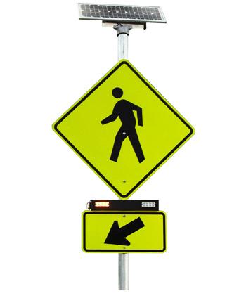
9 City and School District staff met on October 3 to discuss the plan. While some concerns were expressed, overall, they saw it as the best opportunity that will likely become available to make this situation better. The next day, the concept plan was given to School administration to be shared with the School Board for their input. Certain members expressed concerns. A second meeting with both staffs and two school board members was held to review the plan on November 12. At the end of the meeting, members of the School Board requested further review before a decision could be made. At this point, we believe it is best to have the MMTB review and take a position on the concept. It should also be noted that west of the school area, at the Glenhurst Dr. intersection, the plan depicts the installation of pedestrian bumpouts at all four corners. A large number of pedestrians use this intersection, and having a reduced pavement width for them in all four directions appears appropriate. Oak St. & Chesterfield Ave. Intersection F&V has analyzed the current intersection and traffic signal operation. Current traffic counts indicate that a traffic signal is not warranted, even during peak school traffic times. Not only is the signal operation an ongoing expense to the City, it is actually making peak school traffic operations worse. F&V is recommending that the signal be removed, and replaced with a 2- way stop operation, where Oak St. traffic would be given priority, and Chesterfield Ave. traffic would be required to stop. F&V will be in attendance at the meeting, ready to fully review their attached detailed report that spells out how this conclusion has been made. It is possible that there will be public resistance to this idea, therefore, it is important that the Board members understand the rationale that was used to come to this conclusion. The attached Plan A depicts the suggested pavement markings for the west leg of the intersection if a 2-way stop is employed. The 2-way stop configuration allows all eastbound vehicles (including all those exiting from the parent drop off lane) to use the intersection without stopping (unless pedestrians are crossing). Delays would drop dramatically, which in turn helps the new loading zone operation. This is important in that the more efficient the loading zone becomes, the less likely parents will attempt to use other areas (e.g.: Oak St., Chesterfield Ave.) to unload students, which increases safety. The perceived drawback of a 2-way stop is the lack of opportunities for pedestrians to cross Oak St. A crossing guard is always stationed at this intersection during the beginning and end of the school day, and this would continue in the future. The crossing guard s main priority would be to help students in crossing Oak St. A Rectangular Rapid Flashing Beacon (RRFB) would be installed for both directions, warning Oak St. motorists that pedestrians are crossing (see attached picture). The RRFB would be activated by a push-button operation, and could be used at any time of day. At the MMTB meeting, F&V will be able to demonstrate how traffic flows would work using traffic simulation software, both for the current traffic signal, as well as the 2-way stop. It can also be made available at the time of the public hearing. However, if public sentiment is strongly against the 2-way stop configuration, the next alternative that should be considered is a 4-way stop. The 4-way stop configuration would make the intersection more predictable for pedestrians crossing. However, it would reduce the efficiency of Oak St. traffic, which in turn 3
10 reduces the efficiency of the student loading zone, which would then in turn have a negative effect on pedestrians in other areas if students are being unloaded elsewhere. Finally, it is acknowledged that there may be strong public sentiment in favor of maintaining the traffic signal. The current traffic signal operation was installed many years ago with a 2-lane traffic configuration. This has proven to be problematic during the school peak traffic hours, which resulted in a TURNS ban currently in effect during peak traffic times. Such a ban is inconvenient and unfortunate, resulting in extra traffic for all the surrounding streets as motorists attempt to get to their destination without being able to use the main collector routes of the area. The TURNS ban is needed because vehicles waiting to make either left or right turns greatly reduces the number of vehicles that could proceed through the intersection on Oak St., which would then negatively impact the parent loading zone. If the signal should remain, F&V would recommend the installation of a three-lane pavement marking configuration, as shown on the alternate attached Plan B. On this drawing, the proposed pavement width has not been changed, but the bike lanes have been interrupted at the signal. Bicyclists would be encouraged to use the right traffic lane through the intersection. No matter what type of traffic control is selected at the intersection, pedestrian bumpouts would be constructed at all four corners to reduce the pavement width at the crosswalks, wherever possible. The bumpouts have not been drawn out on this plan pending further discussion of other elements of the intersection. The east leg of the intersection is also not finalized, as outlined further in the next section of this memo. Oak St. Chesterfield Ave. to Lakepark Dr. Attached for your use are the suggested cross-sections to consider for Oak St. for this six-block segment. At the meeting in October, survey results had tended to indicate that more than half of the residents along this section consider parking a valuable resource that should not be removed. However, sentiment in this regard was mixed at the meeting. If the MMTB chooses to maintain parking on both sides, the road would have to be built very similar to its current configuration. However, if parking is removed, bike lanes could be added to the street, and the pavement in general could be narrowed by 25%. A hybrid approach would be to build off the fact that the proposed Oak St. alignment in front of the Quarton School would result in pushing through traffic on this street to the north. This alignment could be continued to the east of Chesterfield Ave. for one or more blocks (as determined by the board) to allow the construction of both bike lanes, as well as a parking lane on the south side of the street (no parking would be allowed on the north side). Taking from the comments received to date, since the demand for parking is stronger in the area just east of Chesterfield Ave., it may be wise to consider building one or more blocks with the wider cross-section, then narrowing it down to just travel and bike lanes. Now that N. Eton Rd. is finished with a similar cross-section (two travel lanes, two bike lanes, and one parking lane), I encourage the MMTB members to take a look at that project prior to the meeting to be able to see how such a hybrid cross-section would look on Oak St. If a parking lane is constructed on the south side for several blocks, an opportunity for an improved crosswalk location would also be available, by installing bumpouts on the south side (in the parking lane). This tactic was employed on N. Eton St. We would recommend 4
11 bumpouts at Chesterfield Ave., Pilgrim Ave. (a good mid-point for this segment of road), and Lakepark Dr. (at the park). If preferred, the traffic island discussed in the past on the west side of the Lakepark Dr. intersection could be implemented instead of the south side bumpout. Installation of the traffic island at this location would be most effective due to its location at the bottom of a hill, due to it being visible for a long distance in both directions. Summary To summarize, the MMTB needs to consider the final suggested elements of the Oak St. project plan, and endorse a final concept. Staff will then finalize a package that can be displayed on the City s website, and send letters to all homeowners on the Oak St. corridor (as well as the neighborhood association) encouraging them to review the plan, and notifying them about a planned public hearing. A suggested resolution is provided below based on what staff sees as the most likely concept: SUGGESTED RESOLUTION: The Multi-Modal Transportation Board has endorsed a conceptual plan for the reconstruction of Oak St. from Glenhurst Dr. to Lakepark Dr. featuring the following components: 1. Removal of parking from the west City limit to Glenhurst Dr. to allow the installation of bike lanes on the existing pavement. 2. Construction of pedestrian bumpouts at the Glenhurst Dr. intersection. 3. Construction of a 3 ft. wide street with no parking and bike lanes west of Chesterfield Ave., thereby allowing the construction of a two-lane student loading area in front of Quarton Elementary School (pending approval by the Birmingham School Board). 4. Construction of the Chesterfield Ave. intersection with a 2-way stop configuration, Rectangular Rapid Flashing Beacons for Oak St. traffic, and pedestrian bumpouts. 5. Construction of a 38 ft. wide street with parking on the south side only, and bike lanes on both sides from Chesterfield Ave. to. 6. Construction of a 3 ft. wide street with no parking and bike lanes from to Lakepark Dr. 7. Construction of crosswalk bumpouts at Pilgrim Ave. (if appropriate). 8. Construction of a pedestrian traffic island at the west side of the Lakepark Dr. intersection. Further, to direct staff to prepare documents for the City of Birmingham website portraying these elements, and advising all adjacent property owners and neighborhood associations of a public hearing to be held by this Board at its regularly scheduled meeting of December 4,
12
13
14
15
16 MEMO VIA To: From: Paul O Meara, PE City of Birmingham Michael J. Labadie, PE Steven J. Russo, E.I.T. Fleis & VandenBrink Date: November 11, 214 Re: Summary of Traffic Engineering Analyses for the Oak Street/Chesterfield Avenue Intersection, and Information Regarding the Pick up and Drop-off Zone for Quarton School Introduction Fleis & VandenBrink (F&V) has completed various traffic engineering analyses of the Oak Street & Chesterfield Avenue intersection for the Oak Street Concept development. These analyses included an evaluation of the appropriate warrants from the Michigan Manual of Uniform Traffic Control Devices (MMUTCD) for traffic signals, two-way stop, and all-way stop control. Further, level of service (LOS) analyses and simulations were completed for each traffic control option using new AM and PM peak hour) turning movement counts. Another element of the concept development for Oak Street is the pick-up and drop-off activities at Quarton School. F&V was asked to assist in the development of a concept that would remove the on-street process that is currently being used at the school. F&V assisted the City Engineering Department in the development and evaluation of a concept that mostly fits on the school property, adequately addresses the anticipated demand and will work within the Oak Street concepts under consideration. Traffic Signal Warrants The MMUTCD states, An engineering study of traffic conditions, pedestrian characteristics, and physical characteristics of the location shall be performed to determine whether installation of a traffic control signal is justified at a particular location. The investigation of need for a traffic control signal shall include an analysis of factors related to the existing operation and safety at the study location and the potential to improve these conditions, and the applicable factors contained in the following traffic signal warrants. There are nine warrants, some use traffic volume thresholds as criteria, others use traffic crashes, pedestrian volumes, school crossing, at grade railroad crossing, coordinated signal system or roadway network. The warrants that apply to the intersection of Oak Street and Chesterfield Avenue are traffic volume, pedestrian and school crossing. The results of the evaluation of these warrants are summarized in the following (with the details included in the attachments to this memo): None of the traffic or pedestrian volume warrants are met. The intersection traffic and pedestrian volumes are significantly outside of the necessary thresholds Stansbury Boulevard, Suite 15 Farmington Hills, MI P: F:
17 MEMO The school crossing warrant is not met. The School Crossing warrant is intended for application where the fact that schoolchildren cross the major street is the principal reason for signalization. In order for this warrant to be met, the frequency of adequate gaps in the vehicular traffic stream during the period when schoolchildren are using the crossing, has to be less than the number of minutes in the same period and there must be a minimum of 2 schoolchildren during the highest crossing hour. The applicable information is; in the AM there is a car traveling on Oak Street in front of the school every 8.5 seconds. In the PM there is a car traveling on Oak Street every 11.1 seconds. The approximate acceptable gap time is 13 seconds for the current street width and 1 seconds for the 3 street proposal. There were 97 pedestrians crossing Oak street in the AM and 87 in the PM. The proper use of school crossing guards, etc. is recommended prior to the installation of a traffic signal. From what information is available this procedure was not followed at this location, since a traffic signal is in place at this intersection. A Rectangular Rapid Flashing Beacon (RRFB) (see image in attachment) is warranted based on the pedestrian volume criteria for this Beacon. Although not currently in the MMUTCD, the RRFB has been given interim approval by the Federal Highway Administration (FHWA). Two-Way and All-Way Stop Control Warrants The MMUTCD uses some of the same criteria to warrant the use of stop and yield intersection control as is used for traffic signals. Traffic, bicycle and pedestrian volume thresholds, crashes, etc. are used. However, information regarding available sight distance and approach speeds are also key elements in this determination. The information provided in the attachments indicates that a two-way stop control, with Chesterfield Avenue stopping for Oak Street is appropriate. This is based on the restricted sight distance looking east from the north and south approaches, and the higher traffic volume on Oak Street. Pick-up and Drop-off Lane The stacking space for the pickup / drop-off area should range from 5 to 1,125 depending upon what method is used to determine it. The concept that is shown on the plan (s) has approximately 6 in length. We believe that if used properly this proposed length will adequately serve the school demand. The concept for the pickup / drop-off area is a one way operation, enter at the west and exit at the east. Left turns in at the west end would be allowed, lefts turn out would not be permitted. Parents park their vehicle against the south curb and their child exits the vehicle on the passenger side. The parent pulls away from the curb and uses the drive lane to exit at the east end. Parents are to park where there is an available space in the drop-off area, not wait in line to drop their child at the front door of the school. Children are not to be dropped off in the drive lane. The lane on the south side could be used for parking during non-pickup or dropoff times. This operation will significantly reduce the potential for pedestrian-vehicle conflicts and thus will be much more safe if it properly followed by the parents. Level of Service Descriptions of LOS A through F as defined in the Highway Capacity Manual (HCM) are attached for signalized and unsignalized intersections. Typically LOS D is considered acceptable, with LOS A representing minimal delay and LOS F indicating failing conditions. The results of the analysis of existing conditions are attached and summarized in Table 1. Existing peak hour vehicle delays and Levels of Service (LOS) were calculated at the study intersections using Synchro (Version 8) traffic analysis software. The results of the analysis of existing conditions were Stansbury Boulevard, Suite 15 Farmington Hills, MI P: F:
 LOS (s/veh) LOS 1. Oak Avenue Signalized EB 1. A 9.2 A & Chesterfield Avenue WB 8.7 A 8.")
18 MEMO based on the existing lane use and traffic control, the existing traffic volumes, and the methodologies presented in the HCM 2. Table 1 Existing Intersection Operations AM Peak PM Peak Delay Delay Intersection Control Approach (s/veh) LOS (s/veh) LOS 1. Oak Avenue Signalized EB 1. A 9.2 A & Chesterfield Avenue WB 8.7 A 8.3 A NB 13.1 B 12.8 B SB 13.4 B 12.8 B Overall 1.3 B 9.7 A The results are what should be expected for this intersection with traffic signal control. Weekday Traffic on Oak Street 24-Hour bi-directional count information was collected along Oak Street east of Fairfax Street and west of Glenhurst Drive. The count information is attached and summarized in Table 2 below. Table 2 24-Hour Count Comparison E. of W. of Street Approach Fairfax Glenhurst Oak Avenue EB WB Total The weekday traffic using Oak Street is within the range that would be expected for a street such as Oak Street. Attached: Synchro Results Traffic Volume Data MMUTCD Warrant Analyses Stansbury Boulevard, Suite 15 Farmington Hills, MI P: F:
19 Traffic Data Collection, TDC 754 Sawgrass Drive, Washington, MI 4894 Ph. (586) Traffic Study Performed for: Fleis & Vandenbrink Project: Chesterfield Ave Location: City of Birmingham Weather: Cloudy, 6's Board: DMM #21 File Name : TMC1_Oak&Chesterfield Site Code : TMC 1 Start Date : 1/8/214 Page No : 1 Groups Printed- Pass. Cars - Single Units - Buses/Semi's Chesterfield Avenue Southbound Oak Street Westbound Chesterfield Avenue Northbound Oak Street Eastbound Start Time Rgt Thru Left Peds App. Total Rgt Thru Left Peds App. Total Rgt Thru Left Peds App. Total Rgt Thru Left Peds App. Total Int. Total 7: AM :15 AM :3 AM :45 AM Total : AM :15 AM :3 AM :45 AM Total **** BREAK **** 3: PM :15 PM :3 PM :45 PM Total : PM :15 PM :3 PM :45 PM Total : PM :15 PM :3 PM :45 PM Total Grand Total Apprch % Total % Pass. Cars % Pass. Cars Single Units % Single Units Buses/Semi's % Buses/Semi's Comments: Traffic study conducted during typical weekday (Wed) fron 7:-9: AM morning & 3:-6: PM afternoon peak hours while school was in session. Signalized intersection, with ped signals all quadrants, no push buttons. All approaches signed TURNS 8:3-9: AM & 3:3-4: PM.
 786-547 Traffic Study Performed for: Fleis & Vandenbrink Project: Chesterfield Ave Location: City of Birmingham Weather: Cloudy, 6's Board: DMM #21")
20 Traffic Data Collection, TDC 754 Sawgrass Drive, Washington, MI 4894 Ph. (586) Traffic Study Performed for: Fleis & Vandenbrink Project: Chesterfield Ave Location: City of Birmingham Weather: Cloudy, 6's Board: DMM #21 File Name : TMC1_Oak&Chesterfield Site Code : TMC 1 Start Date : 1/8/214 Page No : 2
 786-547 Traffic Study Performed for: Fleis & Vandenbrink Project: Chesterfield Ave Location: City of Birmingham Weather: Cloudy, 6's Board: DMM #21 File Name : TMC1_Oak&Chesterfield Site Code :")
21 Traffic Data Collection, TDC 754 Sawgrass Drive, Washington, MI 4894 Ph. (586) Traffic Study Performed for: Fleis & Vandenbrink Project: Chesterfield Ave Location: City of Birmingham Weather: Cloudy, 6's Board: DMM #21 File Name : TMC1_Oak&Chesterfield Site Code : TMC 1 Start Date : 1/8/214 Page No : 3 Chesterfield Avenue Southbound Oak Street Westbound Chesterfield Avenue Northbound Oak Street Eastbound Start Time Rgt Thru Left App. Total Rgt Thru Left App. Total Rgt Thru Left App. Total Rgt Thru Left App. Total Int. Total Peak Hour Analysis From 7: AM to 11:45 AM - Peak 1 of 1 Peak Hour for Entire Intersection Begins at 8: AM 8: AM :15 AM :3 AM :45 AM Total Volume % App. Total PHF Pass. Cars % Pass. Cars Single Units % Single Units Buses/Semi's % Buses/Semi's
22 Traffic Data Collection, TDC 754 Sawgrass Drive, Washington, MI 4894 Ph. (586) Traffic Study Performed for: Fleis & Vandenbrink Project: Chesterfield Ave Location: City of Birmingham Weather: Cloudy, 6's Board: DMM #21 File Name : TMC1_Oak&Chesterfield Site Code : TMC 1 Start Date : 1/8/214 Page No : 4 Chesterfield Avenue Southbound Oak Street Westbound Chesterfield Avenue Northbound Oak Street Eastbound Start Time Rgt Thru Left App. Total Rgt Thru Left App. Total Rgt Thru Left App. Total Rgt Thru Left App. Total Int. Total Peak Hour Analysis From 12: PM to 5:45 PM - Peak 1 of 1 Peak Hour for Entire Intersection Begins at 3:3 PM 3:3 PM :45 PM : PM :15 PM Total Volume % App. Total PHF Pass. Cars % Pass. Cars Single Units % Single Units Buses/Semi's % Buses/Semi's.6.5.2
23 Project: Birmingham Quarton School Study Count Type: 24 Hr. ATR Count Weather: Sunny, 6' Degs. Count By: M.Matich Pav't : Asphalt 2 Lanes Traffic Data Collection, TDC 754 Sawgrass Drive, Washington MI (586) Traffic Study Performed For: Fleis & Vandenbrink Page 1 CHESTERFIELDAK_VOL Chesterfield Ave. (4' North of Oak Ave.) Station ID: 2-Way Count Site Code: ATR 2SB Date Start: 7-Oct-14 Start 6-Oct-14 Tue Wed Thu Fri Sat Sun Week Average Time SB NB SB NB SB NB SB NB SB NB SB NB SB NB SB NB 12: AM * * * * 3 1 * * * * * * 2 1: * * * * 1 * * * * * * 2: * * * * * * * * * * 3: * * * * * * * * * * 4: * * * * 1 1 * * * * * * 5: * * * * 3 5 * * * * * * 4 6: * * * * * * * * * * 1 6 7: * * * * * * * * * * : * * * * * * * * * * : * * * * * * * * * * : * * * * * * * * * * : * * * * * * * * * * : PM * * * * * * * * : * * * * * * * * : * * * * * * * * : * * * * * * * * * * : * * * * * * * * * * : * * * * * * * * * * : * * * * * * * * * * : * * * * * * * * * * : * * * * * * * * * * : * * * * * * * * * * : * * * * * * * * * * : * * * * * * * * * * 1 4 Lane Day AM Peak : 8: 8: 8: : 8: Vol PM Peak : 15: 15: 15: 12: 12: : 15: Vol Comb. Total ADT ADT 1,55 AADT 1,55
24 Project: Birmingham Quarton School Study Count Type: 24 Hr. ATR Count Weather: Sunny, 6' Degs. Count By: M.Matich Pav't : Asphalt 2 Lanes Traffic Data Collection, TDC 754 Sawgrass Drive, Washington MI (586) Traffic Study Performed For: Fleis & Vandenbrink Page 1 CHESTERFIELDSOAK_VOL Chesterfield Ave. (45' South of Oak Ave.) Station ID: 2-Way Count Site Code: ATR 2NB Date Start: 7-Oct-14 Start 6-Oct-14 Tue Wed Thu Fri Sat Sun Week Average Time SB NB SB NB SB NB SB NB SB NB SB NB SB NB SB NB 12: AM * * * * 1 * * * * * * 1: * * * * 1 * * * * * * 2: * * * * 1 2 * * * * * * 2 3: * * * * 1 1 * * * * * * 4: * * * * * * * * * * 2 5: * * * * * * * * * * 4 4 6: * * * * * * * * * * : * * * * * * * * * * : * * * * * * * * * * : * * * * * * * * * * : * * * * * * * * * * : * * * * * * * * * * : PM * * * * * * * * : * * * * * * * * : * * * * * * * * : * * * * * * * * * * : * * * * * * * * * * : * * * * * * * * * * : * * * * * * * * * * : * * * * * * * * * * : * * * * * * * * * * : * * * * * * * * * * : * * * * * * * * * * : * * * * * * * * * * 4 4 Lane Day AM Peak : 8: 8: 8: : 8: Vol PM Peak : 15: 17: 15: 12: 12: : 15: Vol Comb. Total ADT ADT 1,51 AADT 1,51
25 Project: Birmingham Quarton School Study Count Type: 24 Hr. ATR Count Weather: Sunny, 6' Degs. Count By: M.Matich Pav't : Asphalt 1 Lane Traffic Data Collection, TDC 754 Sawgrass Drive, Washington MI (586) Traffic Study Performed For: Fleis & Vandenbrink Page 1 OAKECHESTERFIELD_WB Oak Ave. (225' East of Chesterfield Ave.) Station ID: Westbound Site Code: ATR 2WB Date Start: 7-Oct-14 Start Mon Tue Wed Thu Fri Average Sat Sun Week Time 6-Oct-14 Day Average 12: AM * * 5 2 * 4 * * 4 1: * * 2 * 1 * * 1 2: * * 1 2 * 2 * * 2 3: * * 2 * 1 * * 1 4: * * * * * 5: * * 1 1 * 1 * * 1 6: * * * 18 * * 18 7: * * * 15 * * 15 8: * * * 146 * * 146 9: * * 66 8 * 73 * * 73 1: * * * 86 * * 86 11: * * * 97 * * 97 12: PM * * 87 * * 87 1: * * 73 * * 73 2: * * * 93 * * 93 3: * * * 115 * * 115 4: * * * 121 * * 121 5: * * * 146 * * 146 6: * * * 138 * * 138 7: * * * 86 * * 86 8: * * * 67 * * 67 9: * * * 38 * * 38 1: * * * 14 * * 14 11: * 2 6 * * 4 * * 4 Total % Avg. WkDay.% 61.4% 12.6% 46.6%.% 1.% % Avg. Week.% 61.4% 12.6% 46.6%.% 1.%.%.% AM Peak - - 8: 8: - - 8: : - - Vol PM Peak - 17: 15: 12: : : - - Vol Total ADT ADT 1,54 AADT 1,54
26 Project: Birmingham Quarton School Study Count Type: 24 Hr. ATR Count Weather: Sunny, 6' Degs. Count By: M.Matich Pav't : Asphalt 2 Lanes Traffic Data Collection, TDC 754 Sawgrass Drive, Washington MI (586) Traffic Study Performed For: Fleis & Vandenbrink Page 1 OAKWFAIRFAX_VOL Oak Ave. (2' East of Fairfax St.) Station ID: 2 Way Count Site Code: ATR 3 Date Start: 7-Oct-14 Start 6-Oct-14 Tue Wed Thu Fri Sat Sun Week Average Time EB WB EB WB EB WB EB WB EB WB EB WB EB WB EB WB 12: AM * * * * * * * * * * 2 2 1: * * * * 1 3 * * * * * * 2 2: * * * * * * * * * * 2 3: * * * * 1 1 * * * * * * 4: * * * * 2 2 * * * * * * 2 5: * * * * * * * * * * 3 6: * * * * * * * * * * : * * * * * * * * * * : * * * * * * * * * * : * * * * * * * * * * : * * * * * * * * * * : * * * * * * * * * * : PM * * * * * * * * * * : * * * * * * * * : * * * * * * * * : * * * * * * * * * * : * * * * * * * * * * : * * * * * * * * * * : * * * * * * * * * * : * * * * * * * * * * : * * * * * * * * * * : * * * * * * * * * * : * * * * * * * * * * : * * * * * * * * * * 6 3 Lane Day AM Peak : 8: 8: 8: : 8: Vol PM Peak : 16: 15: 15: 12: 12: : 16: Vol Comb. Total ADT ADT 2,871 AADT 2,871
27 Project: Birmingham Quarton School Study Count Type: 24 Hr. ATR Count Weather: Sunny, 6' Degs. Count By: M.Matich Pav't : Asphalt 1 Lane Traffic Data Collection, TDC 754 Sawgrass Drive, Washington MI (586) Traffic Study Performed For: Fleis & Vandenbrink Page 1 OAKWCHESTERFIELD_EB Oak Ave. (175' West of Chesterfield Ave.) Station ID: Eastbound Site Code: ATR 2EB Date Start: 7-Oct-14 Start Mon Tue Wed Thu Fri Average Sat Sun Week Time 6-Oct-14 Day Average 12: AM * * 3 2 * 2 * * 2 1: * * 1 * * * 2: * * * * * 3: * * 1 * * * 4: * * 1 * * * 5: * * 5 5 * 5 * * 5 6: * * * 32 * * 32 7: * * * 146 * * 146 8: * * * 26 * * 26 9: * * * 98 * * 98 1: * * 8 71 * 76 * * 76 11: * * 81 9 * 86 * * 86 12: PM * * 99 * * 99 1: * * 77 * * 77 2: * 8 81 * * 8 * * 8 3: * * * 166 * * 166 4: * * * 144 * * 144 5: * * * 125 * * 125 6: * * * 12 * * 12 7: * * * 7 * * 7 8: * 34 3 * * 32 * * 32 9: * * * 16 * * 16 1: * 9 5 * * 7 * * 7 11: * 1 4 * * 7 * * 7 Total % Avg. WkDay.% 57.5% 11.% 52.3%.% 1.% % Avg. Week.% 57.5% 11.% 52.3%.% 1.%.%.% AM Peak - - 8: 8: - - 8: : - - Vol PM Peak - 15: 15: 12: : : - - Vol Total ADT ADT 1,623 AADT 1,623
28 Project: Birmingham Quarton School Study Count Type: 24 Hr. ATR Count Weather: Sunny, 6' Degs. Count By: M.Matich Pav't : Asphalt 2 Lanes Traffic Data Collection, TDC 754 Sawgrass Drive, Washington MI (586) Traffic Study Performed For: Fleis & Vandenbrink Page 1 OAKWGLENHURST_VOL Oak Ave. (15' West of Glenhurst Ave.) Station ID: 2 Way Count Site Code: ATR 1 Date Start: 7-Oct-14 Start 6-Oct-14 Tue Wed Thu Fri Sat Sun Week Average Time EB WB EB WB EB WB EB WB EB WB EB WB EB WB EB WB 12: AM * * * * * * * * * * 2 4 1: * * * * 1 2 * * * * * * 1 2: * * * * * * * * * * 1 2 3: * * * * * * * * * * 1 2 4: * * * * 1 2 * * * * * * 2 5: * * * * * * * * * * : * * * * * * * * * * : * * * * * * * * * * : * * * * * * * * * * : * * * * * * * * * * : * * * * * * * * * * : * * * * * * * * * * : PM * * * * * * * * : * * * * * * * * : * * * * * * * * * * : * * * * * * * * * * : * * * * * * * * * * : * * * * * * * * * * : * * * * * * * * * * : * * * * * * * * * * : * * * * * * * * * * : * * * * * * * * * * : * * * * * * * * * * : * * * * * * * * * * 4 5 Lane Day AM Peak : 8: 8: 8: : 8: Vol PM Peak : 17: 17: 15: 12: 12: : 17: Vol Comb. Total ADT ADT 3,434 AADT 3,434
29 Warrant Summary Summary of Warrants Spot Number: Major Street: Oak Avenue Minor Street: Chesterfield Avenue Intersection: City/Twp: Oak Avenue at Chesterfield Avenue Birmingham, MI Date Performed: 1/1/214 Performed By: F&V Date Volumes Collected: 1/7/214 Warrant Data Has Been Validated Condition Is Warrant Met YES WARRANT 1: Eight-Hour Vehicular Volume Condition A Condition B Condition A&B N/A WARRANT 2: Four-Hour Vehicular Volume WARRANT 3: Peak-Hour Vehicular Volume WARRANT 4: Pedestrian Volume WARRANT 5: School Crossing WARRANT 6: Coordinated Signal System (Threshold) (Threshold) (1%) (1%) #N/A Condition A #N/A Condition B (1%) Four Hour Peak Hour HAWK RRFB YES WARRANT 7: Crash Experience WARRANT 8: Roadway Network WARRANT 9: Intersection Near a Grade Crossing Issue to Be Addressed by Signalization: Condition A Condition B #N/A Page 1
30 W1 Intersection: Oak Chesterfield Avenue Date 1/1/214 by F&V Michigan Manual of Uniform Traffic Control Devices Worksheet for Signal Warrants (Section 4C) WARRANT 1: Eight-Hour Vehicular Volume % : No. of Lanes on Major St? : No. of Lanes on Minor St? : Speed limit or 85th Percentile? (MPH) : Is the intersection within an Isolated community? : if answer 4 is Yes, then what is the of the population isolated community? : Have other remedial measures been tried? Major Volume (Both Apr.) Minor Volume (One Apr.) Condition A Major Volume USE 1% WARRANTS 1A AND 1B. DO T USE COMBINATION OF A & B Condition A Minor Volume Warrant Condition A Met? Condition B Major Volume Condition B Minor Volume Warrant Condition B Met? Combination Major A Combination Minor A Combination Major B Combination Minor B Time E-W N-S :1-1: N/A N/A N/A N/A 1: - 2: N/A N/A N/A N/A 2: - 3: N/A N/A N/A N/A 3: - 4: N/A N/A N/A N/A 4: - 5: N/A N/A N/A N/A 5: - 6: N/A N/A N/A N/A 6: - 7: N/A N/A N/A N/A 7: - 8: N/A N/A N/A N/A 8: - 9: N/A N/A N/A N/A 9: - 1: N/A N/A N/A N/A 1: - 11: N/A N/A N/A N/A 11: - 12: N/A N/A N/A N/A 12: - 13: N/A N/A N/A N/A 13: - 14: N/A N/A N/A N/A 14: - 15: N/A N/A N/A N/A 15: - 16: N/A N/A N/A N/A 16: - 17: N/A N/A N/A N/A 17: - 18: N/A N/A N/A N/A 18: - 19: N/A N/A N/A N/A 19: - 2: N/A N/A N/A N/A 2: - 21: N/A N/A N/A N/A 21: - 22: N/A N/A N/A N/A 22: - 23: N/A N/A N/A N/A 23: - : N/A N/A N/A N/A Number of Hours that met the warrant 1A = Number of Hours that met the warrant 1B = Number of Hours that met the warrant 1 A & B = Warrant Condition A&B met? A. Is the Minimum Vehicular Volume Warrant Met? (Condition A) B. Is the Interruption of Continuous Traffic Met? (Condition B) C. Combination of Warrants A and B Criteria Met? N/A Page 1


31 6 5 Major St. (Oak Avenue ) Counts Both Approaches Minor St. (Chesterfield Avenue ) Counts One Approach Major St Warrant Threshold 4 Minor St. Warrant Threshold Volume: Vehicle per Hour Time of the day: Hr. FIGURE 1: WARRANT 1A IS THERE A REDUCTION IN THE WARRANT THRESHOLDS TO 7%... 1 DUE TO SPEED? 2 DUE TO ISOLATED COMMUNITY WITH POPULATION LESS THAN 1,? Spot Number: Oak Chesterfield Avenue. OF LANES ON MAJOR ST.? 1. OF LANES ON MIR ST.? 1 Number of Hours that met the Warrant: Does this intersection meet Warrant 1A for signal installation? Data Collection Date: 1/7/214

32 8 7 Major St. (Oak Avenue ) Counts Both Approaches Minor St. (Chesterfield Avenue ) Counts One Approach Major St Warrant Threshold 6 Minor St. Warrant Threshold Volume: Vehicle per Hour FIGURE 1: WARRANT 1B IS THERE A REDUCTION IN THE WARRANT THRESHOLDS TO 7%... 1 DUE TO SPEED? 2 DUE TO ISOLATED COMMUNITY WITH POPULATION LESS THAN 1,? Spot Number: Time of the day: Hr. Oak Chesterfield Avenue. OF LANES ON MAJOR ST.?. OF LANES ON MIR ST.? 1 1 Number of Hours that met the Warrant: Does this intersection meet Warrant 1B for signal installation? Data Collection Date: 1/7/214


33 45 4 Major St. (Oak Avenue ) Counts Both Approaches Minor St. (Chesterfield Avenue ) Counts One Approach Major St Warrant Threshold 1A 35 Minor St. Warrant Threshold 1A Volume: Vehicle per Hour Major St. Warrant Threshold 1B Minor St. Warrant Threshold 1B Time of the day: Hr. FIGURE 3: WARRANT 1A&B Spot Number: Oak Chesterfield Avenue IS THERE A REDUCTION IN THE WARRANT THRESHOLDS TO 56%... 1 DUE TO SPEED?. OF LANES ON MAJOR ST.? 1 2 DUE TO ISOLATED COMMUNITY WITH POPULATION LESS THAN 1,?. OF LANES ON MIR ST.? 1 Number of Hours that met the Warrant: Does this intersection meet Warrant 1A&B for signal installation? N/A Data Collection Date: 1/7/214
34 W2-1% Michigan Manual of Uniform Traffic Control Devices Worksheet for Signal Warrants (Section 4C) WARRANT 2: Four-Hour Vehicular Volume Spot Number: Intersection: Oak Chesterfield Avenue Date 1/1/214 by F&V : No. of Lanes on Major St. : No. of Lanes on Minor St. : Speed limit or 85th Percentile? (MPH) : Is the intersection within an Isolated community? : What is the of the population isolated community? MIR STREET HIGHER VOLUME APPROACH VPH or More Lanes & 2 or More Lanes 2 or More lanes & 1 Lane 1 Lane &1 Lane MAJOR STREET TOTAL OF BOTH APPROACHES VEHICLES PER HOUR (VPH) How Many Hours Are Met Is Warrant 2 (1%) Met? Page 1
35 W3 A Michigan Manual of Uniform Traffic Control Devices Worksheet for Signal Warrants (Section 4C) WARRANT 3 A: Peak-Hour Vehicular Volume Spot Number: Intersection: Oak Chesterfield Avenue Date 1/1/214 by F&V T MET 1 #N/A #N/A #N/A #N/A : : Total Stop Time Delay (hrs) : Minor Street Approach Lanes : Total Approaches : Minor Approach Volume : Total Entering Volume : Peak Hour Is Warrant 3 A Met? #N/A Page 8
36 W3 B-1% Michigan Manual of Uniform Traffic Control Devices Worksheet for Signal Warrants (Section 4C) WARRANT 3 B(1%): Peak-Hour Vehicular Volume Spot Number: Intersection: Oak Chesterfield Avenue Date 1/1/214 by F&V : No. of Lanes on Major St. : No. of Lanes on Minor St. : Speed limit or 85th Percentile? (MPH) : Is the intersection within an Isolated community? : What is the of the population isolated community? MIR STREET HIGHER VOLUME APPROACH VPH or More Lanes & 2 or More Lanes 2 or More lanes & 1 Lane 1 Lane &1 Lane MAJOR STREET TOTAL OF BOTH APPROACHES VEHICLES PER HOUR (VPH) How Many Hours Are Met Is Warrant 3 B (1%) Met? Page 1
37 W4 4HR-1% Michigan Manual of Uniform Traffic Control Devices Worksheet for Signal Warrants (Section 4C) WARRANT 4 (1%): Four-Hour Pedestrian Volume Spot Number: Intersection: Oak Chesterfield Avenue Date 1/1/214 by F&V 2 % 25 : Distance to Nearest Signal or Stop Control on Major Road : Percentage Reduction in Pedestrian Volumes : Speed limit or 85th Percentile? (MPH) : Is the intersection within an Isolated community? : What is the of the population isolated community? 5 Total of All Pedestrians Crossing Major Street Pedestrians per hour (PPH) MAJOR STREET TOTAL OF BOTH APPROACHES VEHICLES PER HOUR (VPH) How Many Hours Are Met Is Warrant 4 B (1%): Four Hour Met? Page 1
38 W5 Michigan Manual of Uniform Traffic Control Devices Worksheet for Signal Warrants (Section 4C) WARRANT 5: School Crossing Spot Number: Intersection: Oak Chesterfield Avenue Date 1/1/214 by F&V 2 3 : Distance to Nearest Signal or Stop Control on Major Road : Width of Street : Number of Children per Group : Safe Gap (Seconds) : Number of Gaps in Study Period : Study Period (Minutes) : Number of School Children Is Warrant 5 Met? Page 15
39 W6 Michigan Manual of Uniform Traffic Control Devices Worksheet for Signal Warrants (Section 4C) WARRANT 6: Coordinated Signal System Spot Number: Intersection: Oak Chesterfield Avenue Date 1/1/214 by F&V The Progressive Movement warrant is satisfied when: 1. On a one-way street or a street which has predominantly unidirectional traffic, the adjacent signals are so far apart that they do not provide the necessary degree of vehicle platooning, or 2. On a two-way street, adjacent signals do not provide the necessary degree of a platooning and the proposed or adjacent signals could constitute a progressive signal system. The installation of a signal according to this warrant should not be considered where the resultant signal spacing is less than 1, feet. Is Warrant 6 Met? Page 16
40 W7 Michigan Manual of Uniform Traffic Control Devices Worksheet for Signal Warrants (Section 4C) WARRANT 7: Crash Experience Spot Number: Intersection: Oak Chesterfield Avenue Date 1/1/214 by F&V 1 1 % % : No. of Lanes on Major St? : No. of Lanes on Minor St? : Has adequate trial of remedial measure with adequate enforcement been tried? : Have there been 5 or more crashes susceptible to correction by Signalization occurred in a 12 month period? Major Volume (Both Apr.) Minor Volume (One Apr.) Condition A Major Volume Condition A Minor Volume Warrant Condition A Met? Condition B Major Volume Condition B Minor Volume Warrant Condition B Met? Time E-W N-S :1-1: : - 2: : - 3: : - 4: : - 5: : - 6: : - 7: : - 8: : - 9: : - 1: : - 11: : - 12: : - 13: : - 14: : - 15: : - 16: : - 17: : - 18: : - 19: : - 2: : - 21: : - 22: : - 23: : - : Number of Hours that met the warrant 7A = Number of Hours that met the warrant 7B = A. Is the Minimum Vehicular Volume Warrant Met Based on Crash Patterns? (Condition A) B. Is the Interruption of Continuous Traffic Met Based on Crash Patterns? (Condition B) Page 17

 Counts Both Approaches Minor St.")
41 Volume: Vehicle per Hour FIGURE 1: WARRANT 7A Spot Number: Oak Chesterfield Avenue. OF LANES ON MAJOR ST.? 1. OF LANES ON MIR ST.? 1 Time of the day: Hr. Number of Hours that met the Warrant: Does this intersection meet Warrant 7A for signal installation? Major St. (Oak Avenue ) Counts Both Approaches Minor St. (Chesterfield Avenue ) Counts One Approach Major St Warrant Threshold Minor St. Warrant Threshold Data Collection Date: 1/7/214
42 7 6 5 Volume: Vehicle per Hour Time of the day: Hr. FIGURE 2: WARRANT 7B Spot Number: Oak Chesterfield Avenue. OF LANES ON MAJOR ST.? 1. OF LANES ON MIR ST.? 1 Number of Hours that met the Warrant: Does this intersection meet Warrant 7B for signal installation? Major St. (Oak Avenue ) Counts Both Approaches Minor St. (Chesterfield Avenue ) Counts One Approach Major St Warrant Threshold Minor St. Warrant Threshold Data Collection Date: 1/7/214
43 W8 Michigan Manual of Uniform Traffic Control Devices Worksheet for Signal Warrants (Section 4C) WARRANT 8: Roadway Network Spot Number: Intersection: Oak Chesterfield Avenue Date 1/1/214 by F&V The need for a traffic signal control study is applicable when the common intersection of two or more major routes meets one or both of the following criteria : (1) has a total existing, or immediately projected, entering volume of at least 1, vehicles during the peak hour and has five-year projected volumes, based on an engineering study, which meet one or more of Warrants 1, 2, and 3 during an average weekday; or (2) has a total existing or immediately projected entering volume of at least 1, vehicles for each of any five hours of a non-normal business day (Saturday and/or Sunday). Is Warrant 8 Met? Page 2
44 W9 Michigan Manual of Uniform Traffic Control Devices Worksheet for Signal Warrants (Section 4C) WARRANT 9: Intersection Near a Grade Crossing Spot Number: Intersection: Oak Chesterfield Avenue Date 1/1/214 by F&V #N/A #N/A Adjustment Factors fail 1 % #N/A #N/A #N/A : Clear Storage Distance (ft) : Number of Approach Lanes Crossing Tracks : Peak Hour : Peak Hour Major Street Volume : Peak Hour Minor Street Volume : Trains per Day : Percentage High Occupancy Busses : Percentage Tractor Trailers : Adjusted Minor Street Volume : Is Figure 4C-1 Satisfied? Is Warrant 9 Met? #N/A Page 21
45 Ped Devices Low Speed Michigan Manual of Uniform Traffic Control Devices Worksheet for Pedestrian Device Thresholds (Section 4F) ALTERNATE PEDESTRIAN DEVICES (SPEED <= 35 mph) Spot Number: Intersection: Oak Chesterfield Avenue Date 1/1/214 by F&V : Distance to Nearest Signal or Stop Control on Major Road : Speed limit or 85th Percentile? (MPH) : Crosswalk Length : Sight Distance Sufficient? Total of all Pedestrians Crossing the Major Street Pedestrians per Hour (PPH) Count Data HAWK 34 ft Crossing HAWK 5 ft Crossing HAWK 72 ft Crossing Hawk 1 ft Crossing RRFB Upper Threshold RRFB Lower Threshold MAJOR STREET TOTAL OF BOTH APPROACHES VEHICLES PER HOUR (VPH) Pedestrian Hybrid Beacon Is the Ped Volume Warrant Met? (See W4 Tabs for Details) Is the School Crossing Warrant Met? (See W5 Tabs for Details) How Many Hours Are Met (HAWK)? Can a HAWK be Considered? Rectangular Rapid Flashing Beacon Hours Meeting RRFB Minimum Criteria Met? Are all Data Points below the RRFB Upper Threshold? Can an RRFB be Considered? 3 YES YES Page 1
46 Warrant Summary Spot Number: Major Street: Oak Avenue Minor Street: Chesterfield Avenue Intersection: City/Twp: Oak Avenue at Chesterfield Avenue City of Birmingham Date Performed: 1/21/214 Performed By: F&V Date Volumes Collected: Summary of Multi-Way STOP Warrants Data Has Been Validated 1/8/214 YES Warrant Condition Is Warrant Met CRITERIA B: Crash History CRITERIA C: Minimum Volumes CRITERIA D: 8% Criteria B, C1, C2 Volume Criteria Crash Criteria Issue to Be Addressed by Multi-way STOP Control: Page 1
47 Criteria B Michigan Manual of Uniform Traffic Control Devices Worksheet for Multi-Way STOP Warrants (Section 2B.7) CRITERIA B: CRASH HISTORY Five or more reported crashes in a 12-month period that are susceptible to correction by a multi-way stop installation. Such crashes include right-turn and left-turn collisions as well as right-angle collisions. : Have there been 5 or more crashes in a 12 month period susceptible to correction by Multi-way stop installation? Is Criteria B Met? Page 2
48 Criteria C Michigan Manual of Uniform Traffic Control Devices Worksheet for Multi-way STOP Warrants (Section 2B.7) Criteria C: Minimum Volumes Intersection: Oak Chesterfield Avenue Date 1/21/214 by F&V : Have there been 5 or more crashes in a 12 month period susceptible to correction by Multi-way stop installation? : No. of Lanes on Major St? : No. of Lanes on Minor St? : Speed limit or 85th Percentile? (MPH) USE 1% FOR CONDITION C Major Volume (Both Apr.) Minor Volume (One Apr.) Condition C Major Volume Condition C Minor Volume Warrant Condition C Met? Time E-W N-S :1-1: : - 2: : - 3: : - 4: : - 5: : - 6: : - 12: : - 13: : - 14: : - 15: : - 16: : - 17: : - 18: : - 19: : - 2: : - 21: : - 22: : - 23: : - : Number of Hours that met Criteria C = A. Is Criteria C Met? Page 3
 Counts One Approach Major St Warrant Threshold 3 Minor St.")


49 Major St. (Oak Avenue ) Counts Both Approaches Minor St. (Chesterfield Avenue ) Counts One Approach Major St Warrant Threshold 3 Minor St. Warrant Threshold Volume: Vehicle per Hour Time of the day: Hr. FIGURE 1: CRITERIA C IS THERE A REDUCTION IN THE WARRANT THRESHOLDS TO 7%... 1 DUE TO SPEED? Spot Number: Oak Chesterfield Avenue. OF LANES ON MAJOR ST.? 1. OF LANES ON MIR ST.? 1 Number of Hours that met the Criteria: Does this intersection meet Criteria C for Multi way stop installation? Data Collection Date: 1/8/214
Minutes of the regular meeting of the City of Birmingham Multi-Modal Transportation Board held June 19, 2014.
 CITY OF BIRMINGHAM START-UP MEETING OF THE MULTI-MODAL TRANSPORTATION BOARD THURSDAY, JUNE 19, 2014 City Commission Room 151 Martin Street, Birmingham, Michigan Minutes of the regular meeting of the City
W. MAPLE RD. STEERING COMMITTEE. A subcommittee of the Multi-Modal Transportation Board
 W. MAPLE RD. STEERING COMMITTEE A subcommittee of the Multi-Modal Transportation Board AGENDA THURSDAY, March 19, 2015 6:00 PM ROOMS 202 & 203 151 MARTIN STREET, BIRMINGHAM A. Roll Call B. Introductions
CITY OF BIRMINGHAM MULTI-MODAL TRANSPORTATION BOARD THURSDAY, DECEMBER 7, 2017 City Commission Room 151 Martin Street, Birmingham, Michigan
 CITY OF BIRMINGHAM MULTI-MODAL TRANSPORTATION BOARD THURSDAY, DECEMBER 7, 2017 City Commission Room 151 Martin Street, Birmingham, Michigan Minutes of the regular meeting of the City of Birmingham Multi-Modal
CITY OF BIRMINGHAM MULTI-MODAL TRANSPORTATION BOARD THURSDAY, AUGUST 3, 2017 City Commission Room 151 Martin Street, Birmingham, Michigan
 CITY OF BIRMINGHAM MULTI-MODAL TRANSPORTATION BOARD THURSDAY, AUGUST 3, 2017 City Commission Room 151 Martin Street, Birmingham, Michigan Minutes of the regular meeting of the City of Birmingham Multi-Modal
CITY OF BIRMINGHAM MULTI-MODAL TRANSPORTATION BOARD THURSDAY, APRIL 9, 2014 City Commission Room 151 Martin Street, Birmingham, Michigan
 CITY OF BIRMINGHAM MULTI-MODAL TRANSPORTATION BOARD THURSDAY, APRIL 9, 2014 City Commission Room 151 Martin Street, Birmingham, Michigan Minutes of the regular meeting of the City of Birmingham Multi-Modal
CITY OF BIRMINGHAM MULTI-MODAL TRANSPORTATION BOARD THURSDAY, MARCH 1, City Commission Room 151 Martin Street, Birmingham, Michigan
 CITY OF BIRMINGHAM MULTI-MODAL TRANSPORTATION BOARD THURSDAY, MARCH 1, 2018 City Commission Room 151 Martin Street, Birmingham, Michigan Minutes of the regular meeting of the City of Birmingham Multi-Modal
City of Birmingham AD HOC RAIL DISTRICT COMMITTEE Monday, December 5, 2016 Meeting 3 p.m. City Commission Room 151 Martin St., Birmingham, Michigan
 City of Birmingham AD HOC RAIL DISTRICT COMMITTEE Monday, Meeting 3 p.m. City Commission Room 151 Martin St., Birmingham, Michigan MINUTES These are the minutes for the Ad Hoc Rail District Committee meeting
MULTI-MODAL TRANSPORTATION BOARD THURSDAY, MARCH 2, :30 PM CITY COMMISSION ROOM 151 MARTIN STREET, BIRMINGHAM
 MULTI-MODAL TRANSPORTATION BOARD THURSDAY, MARCH 2, 2017 6:30 PM CITY COMMISSION ROOM 151 MARTIN STREET, BIRMINGHAM 1. Roll Call 2. Introductions 3. Review of the Agenda 4. Approval of Minutes, Meeting
CITY OF BIRMINGHAM MULTI-MODAL TRANSPORTATION BOARD THURSDAY, JANUARY 4, 2018 City Commission Room 151 Martin Street, Birmingham, Michigan
 CITY OF BIRMINGHAM MULTI-MODAL TRANSPORTATION BOARD THURSDAY, JANUARY 4, 2018 City Commission Room 151 Martin Street, Birmingham, Michigan Minutes of the regular meeting of the City of Birmingham Multi-Modal
MEMORANDUM. Charlotte Fleetwood, Transportation Planner
 MEMORANDUM Date: Updated August 22, 2017 To: Organization: Charlotte Fleetwood, Transportation Planner Boston Transportation Department From: Jason DeGray, P.E., PTOE, Regional Director of Engineering
Complete Street Analysis of a Road Diet: Orange Grove Boulevard, Pasadena, CA
 Complete Street Analysis of a Road Diet: Orange Grove Boulevard, Pasadena, CA Aaron Elias, Bill Cisco Abstract As part of evaluating the feasibility of a road diet on Orange Grove Boulevard in Pasadena,
Project Report. South Kirkwood Road Traffic Study. Meadows Place, TX October 9, 2015
 Meadows Place, TX October 9, 2015 Contents 1 Introduction... 1 2 Data Collection... 1 3 Existing Roadway Network... 2 4 Traffic Volume Development... 2 5 Warrant Analysis... 3 6 Traffic Control Alternative
Traffic Impact Study WestBranch Residential Development Davidson, NC March 2016
 Traffic Impact Study WestBranch Residential Development Davidson, NC March 216 TRAFFIC IMPACT STUDY FOR THE WestBranch Residential Development LOCATED IN DAVIDSON, NC Prepared For: Lennar Carolinas, LLC
TRAFFIC CONTROL DEVICES ON EDGEWATER BOULEVARD AT PORT ROYAL AVENUE (NORTH)
") Attachment 2 DATE: August 6, 2012 TO: VIA: FROM: SUBJECT: Mayor and Members of the City Council James C. Hardy, City Manager Ramon Towne, Director of Public Works Leah Edwards, Assistant Engineer TRAFFIC
Attachment 2 DATE: August 6, 2012 TO: VIA: FROM: SUBJECT: Mayor and Members of the City Council James C. Hardy, City Manager Ramon Towne, Director of Public Works Leah Edwards, Assistant Engineer TRAFFIC
ALLEY 24 TRAFFIC STUDY
 ALLEY 24 TRAFFIC STUDY in City of Frostburg, Maryland January 2013 3566 Teays Valley Road Hurricane, WV Office: (304) 397-5508 www.denniscorporation.com Alley 24 Traffic Study January 2013 Frostburg, Maryland
TRANSPORTATION ANALYSIS REPORT US Route 6 Huron, Erie County, Ohio
 TRANSPORTATION ANALYSIS REPORT US Route 6 Huron, Erie County, Ohio December 12, 2012 Prepared for: The City of Huron 417 Main Huron, OH 44839 Providing Practical Experience Technical Excellence and Client
Ottawa Beach Road Study
 Ottawa Beach Road Study Prepared For: Park Township September 30, 2014 Project No. G140303 OTTAWA BEACH ROAD STUDY PREPARED FOR: PARK TOWNSHIP SEPTEMBER 30, 2014 PROJECT NO. G140303 TABLE OF CONTENTS 1.0
Existing Conditions. Date: April 16 th, Dan Holderness; Coralville City Engineer Scott Larson; Coralville Assistant City Engineer
 Date: April 16 th, 2015 To: From: Re: Dan Holderness; Coralville City Engineer Scott Larson; Coralville Assistant City Engineer Darian Nagle-Gamm, Traffic Engineering Planner Highway 6 (2 nd Street) /
ORANGE COUNTY PUBLIC WORKS TRAFFIC INVESTIGATIONS
 ORANGE COUNTY PUBLIC WORKS TRAFFIC INVESTIGATIONS STAFF REPORT OF: January 6, 2019 SUPERVISORIAL DISTRICT: 5 SUBJECT: LOCATION: INVESTIGATOR: O Neill Drive at Roanoke Drive; Ladera Ranch; TB 922-E6 Clever
Waterford Lakes Small Area Study
 Waterford Lakes Small Area Study Existing Traffic Conditions PREPARED FOR: ORANGE COUNTY PUBLIC WORKS DEPARTMENT TRAFFIC ENGINEERING DIVISION ORLANDO, FLORIDA PREPARED WITH: INWOOD CONSULTING ENGINEERS
CITY OF OAKLAND. 27th Street Bikeway Feasibility and Design. Final Report (v3) March 23, Kimley-Horn and Associates, Inc.
 March 23, Kimley-Horn and Associates, Inc.") CITY OF OAKLAND 27th Street Bikeway Feasibility and Design Final Report (v3) March 23, 2007 PREPARED BY: Kimley-Horn and Associates, Inc. Table of Contents 1. Introduction 3 2. 27 th Street/Bay Place Corridor
CITY OF OAKLAND 27th Street Bikeway Feasibility and Design Final Report (v3) March 23, 2007 PREPARED BY: Kimley-Horn and Associates, Inc. Table of Contents 1. Introduction 3 2. 27 th Street/Bay Place Corridor
CITY OF LOS ANGELES INTER-DEPARTMENTAL MEMORANDUM
 CITY OF LOS ANGELES INTER-DEPARTMENTAL MEMORANDUM Date: April 1, 219 To: Honorable City Council c/o City Clerk, Room 395, City Hall Attention: Honorable Mike Bonin, Chair, Transportation Committee From:
CITY OF WEST LAKE HILLS. Forest View Neighborhood Traffic Calming Study
 CITY OF WEST LAKE HILLS 901 South Mopac Expressway Building V, Suite 220 Austin, Texas 78746 Texas P.E. Firm Registration No. F-929 Klotz Associates Final Report Submittal: March 20, 2015 Revised Final
Walmart (Store # ) 60 th Street North and Marion Road Sioux Falls, South Dakota
 60 th Street North and Marion Road Sioux Falls, South Dakota") Walmart (Store #4865-00) 60 th Street North and Marion Road Sioux Falls, South Dakota Prepared for: Wal-Mart Stores, Inc. Bentonville, Arkansas Prepared by: Kimley-Horn and Associates, Inc. ã2013 Kimley-Horn
Walmart (Store #4865-00) 60 th Street North and Marion Road Sioux Falls, South Dakota Prepared for: Wal-Mart Stores, Inc. Bentonville, Arkansas Prepared by: Kimley-Horn and Associates, Inc. ã2013 Kimley-Horn
MEMORANDUM. DATE March 1, 2012 TO Town of Milton Mark Abbott, Seth Asante, and Efi Pagitsas Boston Region MPO Staff
 MEMORANDUM DATE March 1, 212 TO Town of Milton FROM RE Mark Abbott, Seth Asante, and Efi Pagitsas Boston Region MPO Staff FFY 211 Safety and Operations Analyses at Selected Boston Region MPO Intersections:
Traffic Impact Analysis Chatham County Grocery Chatham County, NC
 Chatham County Grocery Chatham County, NC TABLE OF CONTENTS 1. INTRODUCTION... 1 1.1. Location and Study Area... 1 1.2. Proposed Land Use and Access... 2 1.3. Adjacent Land Uses... 2 1.4. Existing ways...
SCHOOL CROSSING PROTECTION CRITERIA
 CITY OF MADISON TRAFFIC ENGINEERING SCHOOL CROSSING PROTECTION CRITERIA January 2016 Adopted as Policy on August 31, 1976, by Common Council by Amended Resolution #29,540 Amended on September 14, 1976,
Dr. M.L. King, Jr. Street North Complete Streets Resurfacing Opportunities HOUSING, LAND USE, AND TRANSPORTATION COMMITTEE MARCH 22, 2018
 Dr. M.L. King, Jr. Street North Complete Streets Resurfacing Opportunities HOUSING, LAND USE, AND TRANSPORTATION COMMITTEE MARCH 22, 2018 What s Happening The City plans to mill and resurface Dr. M.L.
DUNBOW ROAD FUNCTIONAL PLANNING
 DUNBOW ROAD FUNCTIONAL PLANNING Final Report August 3, 216 #31, 316 5th Avenue NE Calgary, AB T2A 6K4 Phone: 43.273.91 Fax: 43.273.344 wattconsultinggroup.com Dunbow Road Functional Planning Final Report
Caltrans Sloat Boulevard Pedestrian Safety Project Response to Community Questions, Comments & Concerns
 Caltrans Sloat Boulevard Pedestrian Safety Project Response to Community Questions, Comments & Concerns Revised: May 10, 2016 The California Department of Transportation (Caltrans) is planning various
Public Works Committee Meeting Richard E. Mastrangelo Council Chamber November 20, 2017
 Public Works Committee Meeting Richard E. Mastrangelo Council Chamber November 20, 2017 Purpose of Meeting Why are we here? Project Recap/Updates Project Limits/Segments Road Diet Concept Lessons Learned
Arlington Public Schools Thomas Jefferson Site Evaluation Transportation Networks. Thomas Jefferson Working Group Meeting #6 November 10, 2014
 Arlington Public Schools Thomas Jefferson Site Evaluation Transportation Networks Thomas Jefferson Working Group Meeting #6 November 10, 2014 2 3 INTRODUCTION 4 Goal of our work: Identify and assess multi-modal
J Street and Folsom Boulevard Lane Conversion Project (T ) Before and After Traffic Evaluation
 Before and After Traffic Evaluation") J Street and Folsom Boulevard Lane Conversion Project (T15125400) Before and After Traffic Evaluation Prepared by Transportation Division June 2014 Executive Summary On February 12, 2013, the City of Sacramento
J Street and Folsom Boulevard Lane Conversion Project (T15125400) Before and After Traffic Evaluation Prepared by Transportation Division June 2014 Executive Summary On February 12, 2013, the City of Sacramento
Bay to Bay Boulevard Complete Streets Project
 Bay to Bay Boulevard Complete Streets Project Dale Mabry Highway to Bayshore Boulevard February 08, 2018 Photo Source: Tampa Bay Times Alessandra Da Pra Meeting Format Introduction Resurfacing Information
TRAFFIC IMPACT ANALYSIS
 TRAFFIC IMPACT ANALYSIS FOR THE CHAMPAIGN UNIT#4 SCHOOL DISTRICT PROPOSED HIGH SCHOOL (SPALDING PARK SITE) IN THE CITY OF CHAMPAIGN Final Report Champaign Urbana Urbanized Area Transportation Study 6/24/2014
Date: April 7, 2015 To: Chris Hartzell, PE Dakota County, MN From: Jacob Bongard, PE Bolton & Menk, Inc. Subject: Traffic Considerations Memorandum
 M E M O R A N D U M Date: April 7, 2015 To: Chris Hartzell, PE Dakota County, MN From: Jacob Bongard, PE Bolton & Menk, Inc. Subject: Traffic Considerations Memorandum I. Introduction The objective of
SCHOOL ROUTE PLAN. For HUNTER S CREEK ELEMENTARY SCHOOL LOCATION 14 ORANGE COUNTY. Prepared for:
 SCHOOL ROUTE PLAN For HUNTER S CREEK ELEMENTARY SCHOOL LOCATION 14 ORANGE COUNTY Prepared for: ORANGE COUNTY SCHOOL ASSESSMENT PROGRAM ORANGE COUNTY PUBLIC WORKS Traffic Engineering Division 42 South John
Reference number /VP. Lafayette Downtown Congestion Study - Additional Traffic Analysis
 To James Hinkamp and Tony Coe, City of Lafayette Date January 19, 2017 Copies Reference number 243381/VP From Michael Iswalt and Vanessa Peers File reference 4-05 Subject Lafayette Downtown Congestion
Table of Contents FIGURES TABLES APPENDICES. Traffic Impact Study Hudson Street Parking Garage MC Project No.: A Table of Contents
 Traffic Impact Study Hudson Street Parking Garage MC Project No.: 151714A Table of Contents Table of Contents I. INTRODUCTION... 2 II. EXISTING CONDITIONS... 5 III. 215 EXISTING TRAFFIC CONDITIONS... 6
Town of Mooresville, North Carolina Neighborhood Traffic Calming and Control Device Policy
 Town of Mooresville, North Carolina Neighborhood Traffic Calming and Control Device Policy Adopted January 6, 2014 Town of Mooresville Development Services Department TOWN OF MOORESVILLE NEIGHBORHOOD TRAFFIC
Traffic Study of Fuller Street, Cady Street, West Street and West Avenue. Final Report
 Traffic Study of Fuller Street, Cady Street, West Street and West Avenue Final Report July 2005 Prepared for: Town of Ludlow Prepared by: Pioneer Valley Planning Commission 26 Central Street West Springfield,
Traffic Analysis and Design Report. NW Bethany Boulevard. NW Bronson Road to NW West Union Road. Washington County, Oregon
 Traffic Analysis and Design Report NW Bethany Boulevard NW Bronson Road to NW West Union Road Washington County, Oregon May 2011 Table of Contents Table of Contents Section 1 Executive Summary... 2 Section
Evaluation of M-99 (Broad Street) Road Diet and Intersection Operational Investigation
 Road Diet and Intersection Operational Investigation") Evaluation of M-99 (Broad Street) Road Diet and Intersection Operational Investigation City of Hillsdale, Hillsdale County, Michigan June 16, 2016 Final Report Prepared for City of Hillsdale 97 North Broad
Evaluation of M-99 (Broad Street) Road Diet and Intersection Operational Investigation City of Hillsdale, Hillsdale County, Michigan June 16, 2016 Final Report Prepared for City of Hillsdale 97 North Broad
Corporate. Report COUNCIL DATE: May 25, 1998 NO: R1500 REGULAR COUNCIL. TO: Mayor & Council DATE: April 27, 1998
 R1500 : Traffic Safety at 25 Avenue and 128 Street Intersection Corporate NO: R1500 Report COUNCIL DATE: May 25, 1998 REGULAR COUNCIL TO: Mayor & Council DATE: April 27, 1998 FROM: General Manager, Engineering
City of Albert Lea Policy and Procedure Manual 4.10 ALBERT LEA CROSSWALK POLICY
 4.10 ALBERT LEA CROSSWALK POLICY PURPOSE: Pedestrian crosswalks are an integral part of our transportation infrastructure. To be effective and promote safety, marked crosswalks must be installed after
Traffic Signal Redesign 50% Design Report
 Traffic Signal Redesign 50% Design Report Joseph Davis, Jace Elkins, Jordan Weyrauch and Zach Crimmins CENE 486 Capstone J3Z Engineering March 10 th, 2016 Table of Contents 1.0 Project Description...1
FINAL DESIGN TRAFFIC TECHNICAL MEMORANDUM
 FINAL DESIGN TRAFFIC TECHNICAL MEMORANDUM July 2014 FINAL (SR 43) Project Development and Environment Study From State Road 60 (Adamo Drive) to I-4 (SR 400) Hillsborough County, Florida Work Program Item
MEMO DRAFT VIA . Mr. Terry Bailey Foremost Development Company. To: Michael J. Labadie, PE Steven J. Russo, E.I.T. Fleis & VandenBrink.
 MEMO DRAFT VIA EMAIL To: From: Mr. Terry Bailey Foremost Development Company Michael J. Labadie, PE Steven J. Russo, E.I.T. Fleis & VandenBrink Date: August 29, 214 Re: Proposed Apartments City of Walled
Active Transportation Facility Glossary
 Active Transportation Facility Glossary This document defines different active transportation facilities and suggests appropriate corridor types. Click on a facility type to jump to its definition. Bike
TRAFFIC CALMING GUIDE FOR TORONTO CITY OF TORONTO TRANSPORTATION SERVICES DIVISION
 TRAFFIC CALMING GUIDE FOR TORONTO CITY OF TORONTO TRANSPORTATION SERVICES DIVISION CITY OF TORONTO TRANSPORTATION SERVICES DIVISION 2016 TRAFFIC CALMING GUIDE FOR TORONTO TABLE OF CONTENTS Introduction
Traffic Impact Analysis Walton Acres at Riverwood Athletic Club Clayton, NC
 Traffic Impact Analysis Walton Acres at Riverwood Athletic Club Clayton, NC 1. TABLE OF CONTENTS INTRODUCTION...1 1.1. Site Location and Study Area...1 1.2. Proposed Land Use and Site Access...2 1.3.
INDUSTRIAL BUILDING 3009 HAWTHORNE ROAD CITY OF OTTAWA TRANSPORTATION OVERVIEW REVISED. Prepared for: Canada Inc.
 INDUSTRIAL BUILDING 3009 HAWTHORNE ROAD CITY OF OTTAWA TRANSPORTATION OVERVIEW REVISED Prepared for: 7849648 Canada Inc. Octiober 1, 2015 114-598 Overview_2.doc D. J. Halpenny & Associates Ltd. Consulting
Road Conversion Study Plumas Street
 Plumas Street Phase I Submitted to The Regional Transportation Commission of Washoe County Submitted by Zong Tian, Ph.D., P.E. Saeedeh Farivar Haiyuan Li, Ph.D. Center for Advanced Transportation Education
5858 N COLLEGE, LLC N College Avenue Traffic Impact Study
 5858 N COLLEGE, LLC nue Traffic Impact Study August 22, 2016 Contents Traffic Impact Study Page Preparer Qualifications... 1 Introduction... 2 Existing Roadway Conditions... 5 Existing Traffic Conditions...
TRAFFIC IMPACT STUDY. Creekside Thornton, Colorado. For. August 2015 November 2015 Revised: August Prepared for:
 TRAFFIC IMPACT STUDY For Creekside Thornton, Colorado August 215 November 215 Revised: August 216 Prepared for: Jansen Strawn Consulting Engineers 45 West 2 nd Avenue Denver, Colorado 8223 Prepared by:
TRAFFIC STUDY. Birch Bluff Road / Pleasant Avenue 01/15/2018. City of Tonka Bay 4901 Manitou Road Tonka Bay, MN WSB PROJECT NO.
 TRAFFIC STUDY Birch Bluff Road / Pleasant Avenue 01/15/2018 City of Tonka Bay 4901 Manitou Road Tonka Bay, MN 55331 WSB PROJECT NO. 10805-000 Birch Bluff Road/ Pleasant Avenue Traffic Study For: City of
Ad Hoc Birmingham Brand Development Committee (BBDC) CITY HALL COMMISSION ROOM MARTIN ST, Birmingham, MI. WEDNESDAY March 1, :30 PM
 CITY HALL COMMISSION ROOM MARTIN ST, Birmingham, MI. WEDNESDAY March 1, :30 PM") Ad Hoc Birmingham Brand Development Committee (BBDC) CITY HALL COMMISSION ROOM 205 151 MARTIN ST, Birmingham, MI WEDNESDAY March 1, 2017 7:30 PM NOTICE OF MEETING PLEASE TAKE NOTICE that a Regular Meeting
Ad Hoc Birmingham Brand Development Committee (BBDC) CITY HALL COMMISSION ROOM 205 151 MARTIN ST, Birmingham, MI WEDNESDAY March 1, 2017 7:30 PM NOTICE OF MEETING PLEASE TAKE NOTICE that a Regular Meeting
Broadway Street Pedestrian Safety Study Cass Street to 700 Feet North of Randall Avenue
 Broadway Street Pedestrian Safety Study Cass Street to 700 Feet North of Randall Avenue Prepared for: City of De Pere, Wisconsin Prepared by: June, 2017 Broadway Street Pedestrian Safety Study Cass Street
The DC Pedestrian Master Plan
 The DC Pedestrian Master Plan September 28, 2010 George Branyan Pedestrian Program Coordinator District Department of Transportation Presentation Agenda Scope of the Plan Methodology Recommendations Implementation
TRAFFIC IMPACT STUDY
 TRAFFIC IMPACT STUDY for the GLEN ELLEN COUNTRY CLUB SENIOR RESIDENTIAL REDEVELOPMENT 84 Millis, Massachusetts Prepared by: McMahon Associates, Inc. Prepared for: Toll Brothers, Inc. August 216 DRAFT
BOSTON REGION METROPOLITAN PLANNING ORGANIZATION
 PLANNING ORGANIZATIO BOSTON REGION MPO NMETROPOLITAN BOSTON REGION METROPOLITAN PLANNING ORGANIZATION Stephanie Pollack, MassDOT Secretary and CEO and MPO Chair Karl H. Quackenbush, Executive Director,
Columbia Pike Implementation Team (CPIT) Meeting
 Meeting") Columbia Pike Implementation Team (CPIT) Meeting November 30, 2010 Agenda Introductions / Purpose of Meeting Review of project goals Multimodal project: 10% street design between the curbs Discussion Multimodal
Columbia Pike Implementation Team (CPIT) Meeting November 30, 2010 Agenda Introductions / Purpose of Meeting Review of project goals Multimodal project: 10% street design between the curbs Discussion Multimodal
DEPARTMENT OF ENVIRONMENTAL SERVICES. North Harrison Street (Lee Highway to Little Falls Road) Comparative Analysis. Prepared for:
 Comparative Analysis. Prepared for:") DEPARTMENT OF ENVIRONMENTAL SERVICES North Harrison Street (Lee Highway to Little Falls Road) Comparative Analysis Prepared for: Arlington County Department of Environmental Services 2100 Clarendon Boulevard,
DEPARTMENT OF ENVIRONMENTAL SERVICES North Harrison Street (Lee Highway to Little Falls Road) Comparative Analysis Prepared for: Arlington County Department of Environmental Services 2100 Clarendon Boulevard,
THIS PAGE LEFT BLANK INTENTIONALLY
 GA SR 25 Spur at Canal Road Transportation Impact Analysis PREPARED FOR GLYNN COUNTY, GEORGIA 1725 Reynolds Street, Suite 300 Brunswick, Georgia 31520 PREPARED BY 217 Arrowhead Boulevard Suite 26 Jonesboro,
Public Information Meeting. Orange Camp Road. Dr. Martin Luther King Jr. Beltway to I-4. Presented by: Volusia County August 2, 2018
 Public Information Meeting Orange Camp Road Dr. Martin Luther King Jr. Beltway to I-4 Presented by: Volusia County August 2, 2018 1 Project Goals To improve the operations and safety for Orange Camp Road
TRAFFIC SIGNAL WARRANT STUDY
 TRAFFIC SIGNAL WARRANT STUDY 5 th STREET & ENCHANTED PINES DRIVE JANUARY 2013 TRAFFIC OPERATIONS ENGINEERING SERVICES/PUBLIC WORKS DEPARTMENT TABLE OF CONTENTS INTERSECTION LOCATION MAP ii INTRODUCTION
VIVA RETIREMENT COMMUNITIES OAKVILLE TRAFFIC IMPACT STUDY
 VIVA RETIREMENT COMMUNITIES OAKVILLE TRAFFIC IMPACT STUDY VIVA RETIREMENT COMMUNITIES OAKVILLE TRAFFIC IMPACT STUDY DECEMBER 2012 READ, VOORHEES & ASSOCIATES TORONTO, ONTARIO Read, Voorhees & Associates
Donahue Drive Corridor Traffic Operational Evaluation
 Donahue Drive Corridor Traffic Operational Evaluation PREPARED FOR: THE CITY OF AUBURN PREPARED BY: JANUARY 2007 Donahue Drive Corridor Study--Auburn, Alabama TABLE OF CONTENTS Introduction... 1 Background
Table of Figures. Table of Tables. Table 1: Traffic Volumes Ramblas Delay. Table 2: Las
 Table of Contents 1. Executive Summary... 4 2. Analysiss Methodology... 4 3. Introduction... 4 4. Roadway Geometric Conditions... 5 4.1 Las Ramblas Community Access/ Egress Roads... 7 5. Traffic Data Collection...
Average Delay/Vehicle (sec/veh) Signalized. Unsignalized Intersection
 Signalized. Unsignalized Intersection") Attachment: Traffic Analysis Results Traffic simulation modeling analysis was completed for Santa Cruz Ave from Alameda De Las Pulgas to Junipero Serra Blvd. Analysis was performed for existing conditions
Attachment: Traffic Analysis Results Traffic simulation modeling analysis was completed for Santa Cruz Ave from Alameda De Las Pulgas to Junipero Serra Blvd. Analysis was performed for existing conditions
Military Road Safety Improvements
 Military Road Safety Improvements 26 th Road North to 31 st Street North SUMMARY OF DATA REVIEW AND PRELIMINARY RECOMMENDATIONS Prepared for: Department of Environmental Services Traffic Engineering and
DRAFT Davidson Elementary School Expansion Transportation Impact Analysis
 DRAFT Davidson Elementary School Expansion Transportation Impact Analysis Prepared for: Town of Davidson 216 S. Main Street Davidson, NC 28036 Prepared by: Stantec Consulting Services Inc. 2127 Ayrsley
Traffic Circulation Study for Neighborhood Southwest of Mockingbird Lane and Airline Road, Highland Park, Texas
 ARIZONA TEXAS NEW MEXICO OKLAHOMA February 13, 2015 Mr. Meran Dadgostar P.E., R.S. Town of Highland Park 4700 Drexel Dr. Highland Park, Texas 75205 Re: Traffic Circulation Study for Neighborhood Southwest
133 rd Street and 132 nd /Hemlock Street 132 nd Street and Foster Street MINI ROUNDABOUTS. Overland Park, Kansas
 133 rd Street and 132 nd /Hemlock Street 132 nd Street and Foster Street MINI ROUNDABOUTS Overland Park, Kansas September 1, 2017 TABLE OF CONTENTS 1. INTRODUCTION... 1 2. LITERATURE REVIEW... 1 3. CONCEPT
Pedestrian & Bicycle Safety Innovations & Applications
 Pedestrian & Bicycle Safety Innovations & Applications County Engineers Association of Maryland Spring, 2017 Conference May 25, 2017 George Branyan Pedestrian Program Coordinator District Department of
Transportation Planning Division
 Transportation Planning Division Presentation Outline Study Tasks Recap of Previous Meetings Data Collected Focus Areas within Study Limits Design Principles Tool Box Recommended Concepts Schedule Moving
City of Birmingham AD HOC RAIL DISTRICT COMMITTEE Thursday, July 20, 2016 Meeting. City Commission Room 151 Martin St., Birmingham, Michigan
 City of Birmingham AD HOC RAIL DISTRICT COMMITTEE Thursday, Meeting City Commission Room 151 Martin St., Birmingham, Michigan MINUTES These are the minutes for the Ad Hoc Rail District Committee meeting
TOWN OF MORAGA MORAGA WAY AND CAMINO PABLO/CANYON ROAD IMPROVEMENTS Town Council Meeting March 13, 2019
 TOWN OF MORAGA MORAGA WAY AND CAMINO PABLO/CANYON ROAD IMPROVEMENTS Town Council Meeting March 13, 2019 1 Edric Kwan, Public Works Director Josh Peterman, Principal, Fehr and Peers Shawn Knapp, Senior
Chapter 5: Crossing the Street
 Chapter 5: Crossing the Street Whether walking or bicycling, a student s journey to school will more than likely require crossing one or more streets. Per the Safe Routes to School Guide, maintained by
MEMORANDUM. Discussion of the planned crosswalk improvement on Mount Vernon Road near Stratham Drive
 MEMORANDUM To: From: Mayor and City Council Michael Smith, Public Works Director Date: August 24, 2015 Subject: Discussion of the Mount Vernon Road Crosswalk Improvement ITEM DESCRIPTION Discussion of
City of Davis East Covell Corridor Plan
 Community Open House #2 January 22, 2014 6:00 8:00 p.m. Veterans Memorial Center, Club Room City of Davis Introduction The (ECCP) is a taking a comprehensive look at the existing transportation systems
Boston Post Road Design Feasibility Study
 Boston Post Road Design Feasibility Study Prepared for the City of Rye Final Report July 18, 2007 Prepared by: Buckhurst Fish & Jacquemart (BFJ) 115 Fifth Avenue New York, NY 10003 www.bfjplanning.com
CITY OF ALBANY TRAFFIC AND SAFETY COMMISSION
 CITY OF ALBANY TRAFFIC AND SAFETY COMMISSION City Hall - Council Chambers 1000 San Pablo Avenue, Albany, CA 94706 Wednesday, November 30, 2016, 7:00 PM 1. CALL TO ORDER The meeting was called to order
Highway 111 Corridor Study
 Highway 111 Corridor Study June, 2009 LINCOLN CO. HWY 111 CORRIDOR STUDY Draft Study Tea, South Dakota Prepared for City of Tea Sioux Falls Metropolitan Planning Organization Prepared by HDR Engineering,
Orange Center Elementary School
 Drag and drop pic and stretch/crop to the limits of the blue rectangle (delete this text box) Orange Center Elementary School Drag and drop pic and stretch/crop to the limits of the blue rectangle (delete
Date: April 4, Project #: Re: A Street/Binford Street Traffic/Intersection Assessment
 To: Peter Cavanaugh General Electric From: David Bohn, PE Ryan White, PE Date: April 4, 217 Project #: 13421. Re: / Traffic/Intersection Assessment Consistent with the Cooperation Agreement between the
Subject: Bike Project Field Trial Must Validate Bike Safety Claims
 April 12, 2017 To: Menlo Park City Council Subject: Bike Project Field Trial Must Validate Bike Safety Claims A few weeks ago, a collision between my road bike and a white pick-up truck on Woodside Road
STANLEY STREET December 19, 2017
 STANLEY STREET December 19, 2017 Welcome Mike Wiza, Mayor Scott Beduhn, Director of Public Works Agenda 1. Introduction 2. Existing Roadway Conditions 3. Current Alternative Improvements 4. Summary of
10.0 CURB EXTENSIONS GUIDELINE
 10.0 CURB EXTENSIONS GUIDELINE Road Engineering Design Guidelines Version 1.0 March 2017 City of Toronto, Transportation Services City of Toronto Page 0 Background In early 2014, Transportation Services
OFFICE/RETAIL DEVELOPMENT 1625 BANK STREET OTTAWA, ONTARIO TRANSPORTATION BRIEF. Prepared for: Canada Inc.
 OFFICE/RETAIL DEVELOPMENT 1625 BANK STREET OTTAWA, ONTARIO TRANSPORTATION BRIEF Prepared for: 9402209 Canada Inc. December 15, 2015 115-625 Report_2.doc D. J. Halpenny & Associates Ltd. Consulting Transportation
Comments EXECUTIVE SUMMARY
 Comments 1. Under any Alternatives, MCDOT should provide better at-grade pedestrian crossing of Georgia Avenue and Forest Glen Road, including improved crosswalks with wider medians and adequate signal
Lee s Summit Road Improvement Study Public Open House June 7, 2007 Summary of Comment Card Responses
 Lee s Summit Road Improvement Study Public Open House June 7, 2007 Summary of Comment Card Responses Introduction At the Lee s Summit Road Improvement Study Public Open House held Thursday, June 7, 2007
Draft North Industrial Area-Wide Traffic Plan
 Summary of North Industrial and Hudson Bay Industrial Recommended Improvements Table 1. Summary of s Item Location 1 2 3 4 5 6 7 8 9 10 11 12 Millar Ave north of 51st St Super 8 Motel back lane 400 Block
Route 28 (South Orleans Road)/Route 39 (Harwich Road)/Quanset Road Intersection
/Route 39 (Harwich Road)/Quanset Road Intersection") TRAFFIC FEASIBILITY STUDY Route 28 (South Orleans Road)/Route 39 (Harwich Road)/Quanset Road Intersection Orleans, Massachusetts Prepared for: Town of Orleans Prepared by: Fay, Spofford & Thorndike, LLC
TRAFFIC FEASIBILITY STUDY Route 28 (South Orleans Road)/Route 39 (Harwich Road)/Quanset Road Intersection Orleans, Massachusetts Prepared for: Town of Orleans Prepared by: Fay, Spofford & Thorndike, LLC
Drag and drop pic and stretch/crop to the limits of the blue rectangle (delete this text box) Maxey Elementary School
 Maxey Elementary School") Drag and drop pic and stretch/crop to the limits of the blue rectangle (delete this text box) Maxey Elementary School SCHOOL ROUTE PLAN For MAXEY ELEMENTARY SCHOOL LOCATION 33 ORANGE COUNTY Prepared for:
Drag and drop pic and stretch/crop to the limits of the blue rectangle (delete this text box) Maxey Elementary School SCHOOL ROUTE PLAN For MAXEY ELEMENTARY SCHOOL LOCATION 33 ORANGE COUNTY Prepared for:
NO BUILD TRAFFIC OPERATIONS
 3. 23 NO BUILD TRAFFIC OPERATIONS This section addresses the operations of the transportation system and details how it would be expected to function under year 23 No Build conditions with the projected
Lake Whitney Elementary School
 Lake Whitney Elementary School SCHOOL ROUTE PLAN For LAKE WHITNEY ELEMENTARY SCHOOL LOCATION 18 ORANGE COUNTY Prepared for: ORANGE COUNTY SCHOOL ASSESSMENT PROGRAM ORANGE COUNTY PUBLIC WORKS Traffic Engineering
Figure 1: East West Connector Alignment Alternatives Concept Drawing
 Page 2 of 9 Figure 1: East West Connector Alignment Alternatives Concept Drawing The Montebello Drive extension will run north south and connect Wilsonville Road to the Boones Ferry Road to Brown Road
Harrah s Station Square Casino
 Transportation Analysis Harrah s Station Square Casino Pittsburgh, Pennsylvania Submitted To: City of Pittsburgh and Pennsylvania Gaming Control Board Prepared By: DKS Associates GAI Consultants December
Northbound San Jose Avenue & I-280 Off-Ramp Road Diet Pilot Project
 Project Overview Fed by a two-lane Interstate-280 (I-280) off-ramp, high vehicular volumes and speeds are longstanding issues along San Jose Avenue. Residents in the surrounding neighborhoods have expressed