TremonT pedestrian And bicycle LinkAges A TrAnsporTATion for LivAbLe CommuniTies study
|
|
|
- Angela Page
- 6 years ago
- Views:
Transcription

1 A Transportation for Livable Communities Study Pedestrian and Bicycle


2 Introduction: 2 Project Context Lake County Project Description: The project will provide plans and strategies to improve existing roadways and create new pathways to enhance multi-modal transportation; and to improve the pedestrian and bicycle linkages throughout the neighborhood and to the future Ohio & Erie Canal Towpath Trail. Lorain County LAKE ERIE Downtown Cleveland Geauga County Project Goals: To create strategies and standards for the improvement of safe pedestrian and bicycle access on roadways and sidewalks, particularly in designated key corridors. To identify locations and strategies for creating new off-road paths that will enhance the pedestrian and bicycle connections to key neighborhood amenities. To locate connection opportunities to the future route of the Towpath Trail and the Train Avenue Greenway, and to designate specific strategies for implementing these connections. Medina County Cuyahoga County Towpath Trail Summit County Portage County Project Boundaries: Abbey Avenue at the north, which is a connector to the West 25th Street Rapid Transit Station. The Cuyahoga River, and the Towpath Trail to the east, which will eventually travel along a currently unused West 4th Street. MetroHealth Medical Center and Steelyard Commons to the south. West 25th Street and the Train Avenue Greenway to the west.
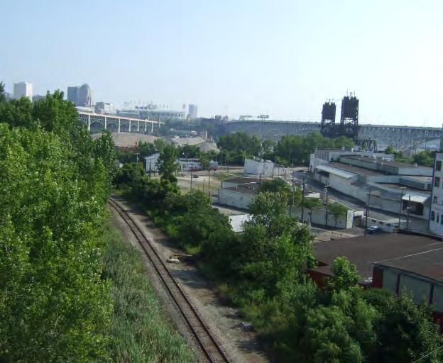
3 Analysis & Inventory: 6 Transportation Infrastructure KE LA K TRAIL LI * AY W EE UE E AV AL W O RT H RU /T RA I GR W In addition to topographic conditions along the river bluffs, interstate highway corridors have created significant barriers to pedestrian movement. The interstates I-90, I-71, and I 490 cut through the neighborhood in various vertical alignments; above grade along the west edge of Central and deeply below grade as I-490 bisects the neighborhood north of Clark Avenue. The I-90 bridge over the Cuyahoga River is slated to be replaced by The proposed new span will create an impact along the northern edge of the neighborhood. The highway system, while serving the vehicular needs of the entire region, brings people and goods to and from. Unfortunately, highway right-of-ways are extremely wide in most locations, that has impacted the overall fabric of the neighborhood and will be an urban design challenge to mend. Pedestrian bridges occur at West 11th street over I-490 and Buhrer Avenue over I-71 and provide vital although under utilized linkages. In addition to highways, bridges along Abbey and Clark, reconstructed in the 1980s have provide important pedestrian linkages to Duck Island and the West 25th Street business district and the Flats respectively. orth / South Bus routes operated by the Greater Cleveland Regional Transit Authority are available along West 25th street, while the 81 route serves the neighborhood, providing public transportation to downtown and the Rapid Transit Redline Station at Lorain Avenue and West Twenty-fifth Street. Key Service Area Boundary Bus Route Red Line Scenic Byway Existing Towpath Trail Proposed Towpath Trail Other Proposed Trail City Bikeway eighborhood Connector Interstate Bridge


4 AA Highest Elevations Highway overpasses and bridges Up slope Elevations Relatively flat. Urban grid streets forming residential neighborhoods. Slopes Transition from Floodplain to Up slope. Some residential, mostly too steep to inhabit. Floodplain Elevations Flat area adjacent to Cuyahoga River. Historic industrial valley, now some retail. Topography Analysis & Inventory: 7 This map shows the relative elevations throughout. There is the floodplain valley and the up slope plateau separated by an steep elevation difference of 50 or more. The challenge of the topography is that access to other neighborhoods and the river is dependent upon bridges or other larger engineered solutions to navigating the topography. The Towpath Trail will be located midslope throughout most of its section. The challenge of this location is making connections to the neighborhood that are bike-able and also bringing some of the neighborhood flair to the trail. Towpath Trail View from 3rd and Jefferson looking uphill, the Towpath Trail will intersect Jefferson midway up the hill. Professor Street Thurman Street W 7th Street W 6th Street W 5th Street W 4th Street Towpath Route W 3rd Street Cuyahoga River Section AA
5 Analysis & Inventory: 8 eighborhood Amenities For residents, these are some of the key locations that they travel to and from on a regular basis. The two libraries serve on either side of the highway, and both are on bus routes. * The schools are relatively well distributed throughout the neighborhood, although in cases such as the Buhrer school, children need to be able to cross the highway safely and comfortably. + While there are many small markets throughout the neighborhood, the West Side Market and Dave s are where many people do their grocery shopping. Access across the Abbey Avenue bridge is a key link to this part of neighboring Ohio City. This is also where the W. 25th Street Rapid station is located, which provides access to the airport, downtown Cleveland and beyond. Library Grocery + Hospital School Summer Farmer s Market Dog Park
6 Analysis & Inventory: 9 Visitor Attractions * U U U U U U U b U The renaissance of the neighborhood has spawned numerous fine restaurants, taverns, coffee shops and confectioners. The neighborhood is home to fascinating historic churches of diverse denominations. Art galleries and boutiques proliferate, a weekly farmer s market and special events during the summer months are found in Lincoln Park, emergency medical facilities are available, and a bike repair shop awaits the trail users. o other community adjacent to the Towpath Trail will feature such a diversity of amenities for the trails users. U U Historic Church 1 or more restaurants U + 1 or more art galleries Summer Farmer s Market Hospital Steelyard Commons Shopping Center A Christmas Story House and Museum b Bicycle Shop

7 Analysis & Inventory: 10 Growth and Development continues to boast a diversity of new and renovated housing stock. Steelyard Commons provides for citywide shopping needs. The new K-8 Buhrer Elementary School will open in 2009, just west of the I-71 / Buhrer pedestrian bridge. * BERGE VILLAGE The replacement of the Innerbelt bridge into downtown Cleveland will have a significant impact on the neighborhood. Construction is anticipated to last several years. Views into the neighborhood from the elevated highways afford some of the most intimate portraits of Cleveland s neighborhoods for through-travelers. Under the elevated highway and bridges the neighborhood s side streets need to function for the community. On and off ramps are vital to providing access, yet the interface of the ramps with the neighborhood are of paramount design importance. Safe pedestrian crossings, traffic management, and clear directional orientation are all important design considerations for bridge related development. Current/ Recent Development Steelyard Commons Shopping Center BREVIER HOUSIG WEST 11TH STREET STARKWEATHER PLACE TREMOT PLACE LOFTS TREMOT POITE ew Housing ew School SPAISH AMERICA COMMITTEE OFFICES Planned Future Development Housing Innerbelt Bridge Reconstruction Civic / on-profit Towpath Trail
8 Analysis & Inventory: 12 Block Club Areas of Concern This map highlights areas of concern mentioned at the initial block club meetings. The range of issues affecting these areas was wide ranging, and most require very specific interventions. People focused on issues related to the quality of the streetscape experience on the side- and neighborhood-streets, as well as at key connection nodes. The main automobile routes were less often areas of concern to the residents, except where they came into conflict with non-automobile routes of travel, such as at the 14th Street roundabout. Issues raised regarding the neighborhood streets addressed concerns about safety, accessibility and aesthetic improvements. *


9 Analysis & Inventory: 13 eighborhood Wide Concerns O CURB RAMP OR CROSSWALK Some comments were repeated by numerous block clubs, or were not specific to one area, but represented more general concerns about s pedestrian infrastructure. Accessibility, in all weather arrow barricaded sidewalks, and steep slopes Sidewalks in poor repair Missing street trees Dead tree removal Missing Sidewalks - Steep Slopes Pedestrian and bike access on bridges Safe route to W25th Rapid Transit Station Control illegal parking
10 17 Recommended Areas of Action


11 E DG Introduction: 2 IE G E Areas of Action - orth AR RA LO LO W TO W K LA D TRAIL W O IERBELT BRIDGE RECOSTRUCTIO AREA W TO O TO K E LI C - I RA E DG RI EB GI E AR -C I I BR TO FUTURE GREESPACE D * E AK L K TRAIL LI IERBELT BRIDGE RECOSTRUCTIO AREA AY W EE UE E GR FUTURE GREESPACE AV RU /T RA I W O RT H West 25th Street Rapid Station W AL * Enhance Edge to take advantage of view Key AY W UE E AV /T RA I GR RT H RU West 11th looking south O W AL W Service Area Bus Route Red Line Scenic Byway Existing Towpath Trail Proposed Towpath Trail Other Proposed Trail City Bikeway Connector Existing Bike Lane Streetscape Improvement Bicycle Boulevard Connection Improvement Transit Waiting Environment Bike Amenity eighborhood Gateway EE Lincoln Park Transit Waiting Environment Location Towpath Trailhead orth entrance to pedestrian bridge obscured Towpath Local Access River Overlook Scenic Views West 11th pedestrian bridge over highway as seen from West 14th bridge Towpath Trail - Clark Field


12 Areas of Action - South E DG RI EB GI E AR I RA AY LO TO KE LA LIK D TRAIL IERBELT BRIDGE RECOSTRUCTIO AREA FUTURE GREESPACE * A RU /T RA I E U VE W TO W O W EE GR -C AY I /T RA RU RT H O W AL Looking south at West 11th, no sidewalks, no indication of park location GR AV W RT H W AL W O Shady side streets are more pleasant for pedestrians W EE UE E Key Service Area Bus Route Red Line Scenic Byway Existing Towpath Trail Proposed Towpath Trail Other Proposed Trail City Bikeway Connector Existing Bike Lane Streetscape Improvement Bicycle Boulevard Connection Improvement Transit Waiting Environment Bike Amenity eighborhood Gateway Clark Avenue bridge needs sidewalk improvements Buhrer pedestrian bridge Buhrer School East end of Buhrer pedestrian bridge Towpath Trailhead Towpath Local Access River Overlook Scenic Views 0 West entrance to Buhrer pedestrian bridge Quigley Pedestrian Underpass Steep hill at Holmden Avenue
13 20 Phasing
14 Phasing: 21 Complete W 7th gateway and pedestrian crosswalks. Complete transit waiting environments on W 14th at Lincoln Park. Begin addition of bike route signage and lane marking. Begin to implement bicycle amenities such as maps and parking. Visibility and access improvements to pedestrian bridges at W 11th and Buhrer. Begin curb ramp installation. Implement standard crosswalk detail and begin re-striping. Reconfigure roundabout signage and striping. Phasing - 1 Year Goals


15 Action Strategy For Phased Implementation - 1 year goals Phasing: 22 Complete W 7th gateway and pedestrian crosswalks. Complete transit waiting environments on W 14th at Lincoln Park. Begin addition of bike route signage and lane marking. Begin to implement bicycle amenities such as maps and parking. Visibility and access improvements to pedestrian bridges at W 11th and Buhrer. Begin curb ramp installation. Implement standard crosswalk detail and begin re-striping. Reconfigure roundabout signage and striping.

16 Phasing: 23 Action Strategy For Phased Implementation - 1 year goals Complete W 7th gateway and pedestrian crosswalks. Complete transit waiting environments on W 14th at Lincoln Park. Begin addition of bike route signage and lane marking. Begin to implement bicycle amenities such as maps and parking. Visibility and access improvements to pedestrian bridges at W 11th and Buhrer. Begin curb ramp installation. Implement standard crosswalk detail and begin re-striping. Reconfigure roundabout signage and striping.


17 Action Strategy For Phased Implementation - 1 year goals Phasing: 24 Complete W 7th gateway and pedestrian crosswalks. Complete transit waiting environments on W 14th at Lincoln Park. Begin addition of bike route signage and lane marking. Begin to implement bicycle amenities such as maps and parking. Visibility and access improvements to pedestrian bridges at W 11th and Buhrer. Begin curb ramp installation. Implement standard crosswalk detail and begin re-striping. Reconfigure roundabout signage and striping.


18 Phasing: 25 Action Strategy For Phased Implementation - 1 year goals Complete W 7th gateway and pedestrian crosswalks. Complete transit waiting environments on W 14th at Lincoln Park. Begin addition of bike route signage and lane marking. Begin to implement bicycle amenities such as maps and parking. Visibility and access improvements to pedestrian bridges at W 11th and Buhrer. Begin curb ramp installation. Implement standard crosswalk detail and begin re-striping. Reconfigure roundabout signage and striping.


19 Phasing: 26 Existing W 11th Bridge Entry Action Strategy For Phased Implementation - 1 year goals Complete W 7th gateway and pedestrian crosswalks. Complete transit waiting environments on W 14th at Lincoln Park. Begin addition of bike route signage and lane marking. Begin to implement bicycle amenities such as maps and parking. Visibility and access improvements to pedestrian bridges at W 11th, Abbey and Buhrer. Begin curb ramp installation. Implement standard crosswalk detail and begin re-striping. Reconfigure roundabout signage and striping. Existing Buhrer Bridge Entry Existing Abbey Bridge


20 Phasing: 27 Action Strategy For Phased Implementation - 1 year goals Complete W 7th gateway and pedestrian crosswalks. Complete transit waiting environments on W 14th at Lincoln Park. Begin addition of bike route signage and lane marking. Begin to implement bicycle amenities such as maps and parking. Visibility and access improvements to pedestrian bridges at W 11th, Abbey and Buhrer. Begin curb ramp installation. Implement standard crosswalk detail and begin re-striping. Reconfigure roundabout signage and striping. OLY 1 CURB RAMP O CROSSWALKS O CURB RAMPS

21 Intersections & Streetscapes: 51 Overall Map of Intersection Improvements Intersections present a high level of risk for cars, pedestrians and bicyclists. These improvements are designed to alleviate the conditions that increase those risks, including poor sight lines and long, akward crossings. Adding bump-outs improves clear sight lines at intersections by keeping parked cars back from the corner, and they also allow shorter crossing distances for pedestrians. This also provides the opportunity to install ADA compliant curb ramps and crosswalks throughout the neighborhood. The grid of shifts in the middle of the neighborhood creating a series of angled intersections along West 10th Street. These intersections can be disorienting for drivers, but are even more challenging for pedestrians faced with extremely wide crossing distances. Again, bump-outs are beneficial to the safety of the intersections. Additionally, where possible the existing angeled intersections are revised to safer 90-degree versions. Improve Intersection Shared Valet Zone Bicycle Boulevard Future Towpath Trail


22 Intersections & Streetscapes: 52 Typical Professor Intersection with Streetscape Bump-Out Options PROFESSOR Valet Pick-up Zone Sidewalk Shifts to Curb Valet Drop-off Zone Return Bump-Out at Curb Drain Inlet Outdoor Cafe Contiguous with Storefront Crosswalk Stencil over Striping JEFFERSO Return Bump-Out at Curb Drain Inlet This option preserves the existing curb drain. Tree Lawn Biofiltration with Curb Scupper This option envelopes the existing drain in a new biofiltration zone contiguous with the existing planted area of the tree lawn. Water enters through a slot, or scupper, in the curb, is absorbed and filtered by the new plantings, and the overflow goes down the drain. Urban Biofiltration with Curb Scupper This is similar to the Tree Lawn Biofiltration, but the planted area is contained within a planter. Water enters through a scupper, is absorbed and filtered, then overflow exits through the drain. Slotted Curb / Gutter with Cover This option allows the curb bump-out to expand past the existing curb drain without requiring moving the drain. Slotted Curb/ Gutter with Plate Cover to Drain Inlet Bus Pad and Stop Urban Biofiltration with Curb Scupper Tree Lawn Biofiltration with Curb Scupper SCALE: 1 =


23 Intersections & Streetscapes: 53 Perspective of the orth-west Corner of Professor and Jefferson Existing Corner Example of stencil over standard crosswalk striping


24 Intersections & Streetscapes: 54 West 7th and Jefferson - Typical West 7th Four-Way Intersection W 7TH JEFFERSO SCALE: 1 =


25 Intersections & Streetscapes: 55 West 7th and College (with driveway extensions) SCALE: 1 =


26 Intersections & Streetscapes: 56 West 10th and Fairfield / Professor Tree Lawn Biofiltration with Curb Scupper Intercept Parking Lot Runoff at ew Planter Tree Lawn Biofiltration with Curb Scupper W 10TH Public Art Element Pervious Paving Connected to Biofiltration FAIRFIELD Tree Lawn Biofiltration with Curb Scupper Crosswalk Stencil over Striping Urban Biofiltration with Curb Scupper Pervious Paving Urban Biofiltration with Curb Scupper Pervious Paving Tree Lawn Biofiltration with Curb Scupper PROFESSOR SCALE: 1 =


27 Intersections & Streetscapes: 63 Starkweather and Professor Transition of 2-way to 1-way Street PROFESSOR STARKWEATHER 0 SCALE: =

28 Intersections & Streetscapes: 61 West 10th At Jefferson and Starkweather - Traffic Circle JEFFERSO W 10TH STARKWEATHER SCALE: 1 =

29 Intersections & Streetscapes: 62 West 10th At Jefferson and Starkweather - Separate Intersections JEFFERSO W 10TH STARKWEATHER SCALE: 1 =


30 Intersections & Streetscapes: 64 Jefferson and Thurman THURMA OE WAY JEFFERSO SCALE: 1 =


31 Action Strategy For Phased Implementation - 1 year goals Phasing: 29 Complete W 7th gateway and pedestrian crosswalks. Complete transit waiting environments on W 14th at Lincoln Park. Begin addition of bike route signage and lane marking. Begin to implement bicycle amenities such as maps and parking. Visibility and access improvements to pedestrian bridges at W 11th, Abbey and Buhrer. Begin curb ramp installation. Implement standard crosswalk detail and begin re-striping. Reconfigure roundabout signage and striping. Photo Courtesy of Plain Press

32 Intersections & Streetscapes: 72 West 14th at Roundabout W 14th Rumble Strips on Off Ramps QUIGLEY I-71 Rumble Strips on Off Ramps Pedestrian and Bike Lane on orth W 17th Shift Traffic Lanes to the South SCALE: 1 =


33 Intersections & Streetscapes: 73 Viaduct Connection to Valentine I-71 Pedestrian and Bike Lane on orth Pedestrian Access to West 17th Shift Traffic Lanes to the South W 17th SCALE: 1 = VALETIE

34 Phasing: 29 Bicycle Boulevard improvements University to Clark Field Buhrer Pedestrian Bridge Abbey Avenue Streetscape and Bridge Pedestrian / Bicycle Improvements Phasing - 3 Year Goals


35 Intersections & Streetscapes: 68 West 11th Bicycle Boulevard at Kenilworth and Literary W 11th LITERARY Bicycle boulevards are low-volume and low-speed streets that have been optimized for bicycle travel through treatments such as traffic calming and traffic reduction, signage and pavement markings, and intersection crossing treatments. These treatments allow through movements for cyclists while discouraging similar through trips by non-local motorized traffic. Motor vehicle access to properties along the route is maintained. (Funamentals of Bicycle Boulevard Planning and Design, Walker et. al., 2009) KEILWORTH SCALE: 1 =50-0 Lincoln Park Example of Bicycle Boulevard in Portland
36 Intersections & Streetscapes: 69 West 11th Between Lincoln Park and Clark Field - 11th and Starkweather Lincoln Park STARKWEATHER Pedestrian Refuge at Crossing West 11th Bicycle Boulevard W 11TH SCALE: 1 =

37 Intersections & Streetscapes: 70 West 11th Bicycle Boulevard Between Lincoln Park and Clark Field AUBUR arrow Street Remove Overhead Fencing SCALE: 1 = Renovate

38 Intersections & Streetscapes: 71 West 11th Between Lincoln Park and Clark Field - Pedestrian Bridge Remove Overhead Fencing Renovate Bridge Remove Overhead Fencing Connection to West 12th Connection to Clark Field Future Towpath Trail Route SCALE: 1 =

39 Bridges: 47 West 11th Pedestrian Bridge W 11th AUBUR Existing Conditions Perspective Toward orth Side of Bridge arrow Street Remove Overhead Fencing Renovate Bridge Remove Overhead Fencing Connection to Clark Field Connection to West 12th W 11th Perspective Looking Toward orth Side of Bridge


40 Bridges: 42 Buhrer and West 11th Pedestrian Bridges


41 Bridges: 43 Existing Conditions at Pedestrian Bridges These two bridges provide vital links over the interstates which divide. Both the Buhrer pedestrian bridge over I-71 and the West 11th bridge over I-490 are 8 wide bridges with chain link vandal fence the entire length. The bridges are accessed via dead-end roads. Their entrances are currently in line with the existing sidewalks, but this location makes them difficult to see from the other end of the street. Additionally, there are no signs indicating the presence of the bridges. Bollards at both ends of the bridges are designed to prevent people driving onto the bridges, but they also make it difficult for bicycles, wheelchairs and baby strollers to get by. The chain link fencing is low overhead and makes the bridge feel very oppressive. East side of Buhrer bridge orth side of West 11th bridge West side of Buhrer bridge On West 11th bridge looking south


42 Precedents for Pedestrian Bridge Treatment Options Bridges: 44 Historic Rail Bridge style Sculptural frame covered in chain link with decorative metal railing when bridge is not over roadway Lace Fence - woven patterns in chain link product Tubular tunnel


43 Bridges: 45 West 11th Pedestrian Bridge The West 11th pedestrian bridge provides a critical neighborhood link across I-490, and it will only become more important when the Towpath Trail is constructed. The current bridge is run down, narrow and has a low chain link railing overhead for the entire length of the bridge. Both entrances are obscured from sight and riddled with obstructions that make walking access difficult and bicycle access even more so. Proposed changes include ways to create a wider bridge and new railings that are less constricting while still providing the necessary safety. Existing Bridge Section Option 1 Bridge Section - Fill between existing curbs, place new railing on outside of structure, gaining 16 width. ew overhead railing is raised to 10-6 height, creating a less constricted feeling. Option 2 Bridge Section - Place new deck with 8 cantilever on top of existing bridge deck.!0-0 clear to overhead beams.


44 Intersections & Streetscapes: 72 West 14th and Buhrer Text here Buhrer School arrow Buhrer Uciist omnitiori volorro od eum quiaese nessimuscime volorestis aute cullor secupta tatest aut eic tem facearc hillabor suntur seri cor secae nossini molupti id qui volorro quamet quo enimus ventias es excerum quid quo tor molorio nseque eictiate provid quo ventem fugiti ullabor itaquidebit, cone pore non consed qui discit ipitior entur? Solorer ferspeliquo que pro ma quae odi am quatet lacitiberro officte seribus. Litat qui voluptia pa si opta desserum BUHRER Renovated Bridge W 14th HOLMDE I-71 Signalized Crosswalk at Holmden Intersection West 14th End of Bridge Remove Crosswalk Rumble Strips on Off Ramps QUIGLEY SCALE: 1 = West 17th End of Bridge

45 Bridges: 47 Buhrer Pedestrian Bridge Existing Bridge Section Option 1 Bridge Section - Fill between existing curbs, place new railing on outside of structure, gaining 12 width. ew overhead railing is raised to 10-0 height. Option 2 Bridge Section - Place new deck with 15 cantilever on top of existing bridge deck clear to overhead fencing.


46 Bridges: 49 Buhrer Pedestrian Bridge Buhrer School Perspective #1 Remove Overhead Railing Renovate Bridge and Railing Remove Overhead Railing Perspective #2 BUHRER Improve Sidewalk and Crosswalks I-71 arrow Road W 14th Perspective #1: West Side of Bridge near Buhrer School Existing Conditions Existing Conditions Perspective #2: East Side of Bridge near West 14th


47 Bridges: 33 Abbey Avenue and Viaduct


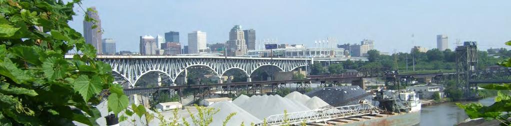
48 Bridges: 34 Existing Conditions Abbey Avenue provides the main connection between and many key destinations, including: The RTA Red Line Station; groceries at the West Side Market and Dave s; and bicycle access to the Lorain-Carnegie Bridge. This connection will become even more critical when the new Innerbelt bridge is under construction. It is also a major gateway for people entering from the west side of Cleveland. Current conditions on the viaduct are unsightly and dangerous for bicyclists and pedestrians. The crash barriers along the sidewalks trap trash and debris, and in the winter fill with snow and ice. Bicyclists complain that the large drains along both sides of the road are extremely dangerous and force them to swerve into traffic. From an aesthetic standpoint, Abbey Avenue and Abbey Viaduct present amazing opportunities to create a gateway into the neighborhood that showcases the incredible view of downtown Cleveland from the bridge and sets the tone for bicycle and pedestrian accommodations throughout.


49 Bridges: 35 Abbey Viaduct Abbey Viaduct gets new bike lanes, decorative lighting, the barriers between the road and sidewalk are removed, and the fencing is replaced with new 48 height decorative railings with vandal fencing only where necessary. Widen bridge, replace existing parapet walls and fence. Remove existing crash barriers SIDEWALK BIKE LAE DRIVE LAE DRIVE LAE BIKE LAE SIDEWALK The renovated bridge over the RTA Red Line Tracks, three blocks to the west, provides a model for how the viaduct gets renovated.

50 Bridges: 36 Abbey Viaduct Abbey Viaduct gets new bike lanes, decorative lighting, the barriers between the road and sidewalk are removed, and the fencing is replaced with new 48 height decorative railings with vandal fencing only where necessary.

51 Abbey Avenue Intersections & Streetscapes: 74 COLUMBUS ABBEY BIKE LAE BIKE LAE W 21ST SCALE: 1 =

52 Intersections & Streetscapes: 75 Abbey Avenue W 19TH W 20TH BIKE LAE ABBEY BIKE LAE SCALE: 1 =


53 Abbey Avenue Intersections & Streetscapes: 76 GATEWAY LOCATIO W 19TH ABBEY AVEUE VIADUCT BIKE LAE BIKE LAE SCALE: 1 =

54 Intersections & Streetscapes: 77 West 20th Connection to Lorain SCALE: 1 = W 20TH BIKE LAE


55 EXISTIG SECTIO Intersections & Streetscapes: 78 West 20th Connection to Lorain Utility Pole On Street Parking Utility Pole 4 Houses West 20th Street is currently a narrow street, but could be widened by three feet without moving any existing power poles. This would allow for the addition of a bike lane connecection between Abbey and Lorain. Parking Lot Sidewalk Sidewalk WEST EAST 60 R.O.W. PROPOSED SECTIO Utility Pole Utility Pole Houses ew Street Trees Max Height Below Overhead Wires On Street Parking Widen Cartway 3-0 Bike Lane Sidewalk Sidewalk WEST EAST 60 R.O.W.

56 SCALE: 1 = BIKE LAE BIKE LAE Intersections & Streetscapes: 78 West 20th Connection to Lorain BIKE LAE LORAI W 20TH BIKE LAE

57 Phasing: 30 Towpath Connectors Phase 1 Innerbelt Bridge improvements including new art wall and parking lots. Phasing - 5+ Year Goals


58 Bridges: 37 I-90 / Innerbelt Bridge Zone

59 Bridges: 38 Existing Conditions
60 Bridges: 39 Innerbelt Bridge Phase 1 The new Innerbelt Bridge will create many changes within. It will necessitate removing buildings and reconfiguring a number of roads. These changes provide opportunities for additional parking, neighborhood beautification and new pedestrian connections.

61 Bridges: 40 Innerbelt Bridge Phase 2 Phase 2 entails tearing down the existing bridge and building a new bridge in its place. The enhancements started in Phase 1 continue with Phase 2. Additional parking needs can be evaluated at this time to ascertain if additional parking is desirable. Links to the Towpath Trail should be finalized.


62 Bridges: 41 Wall Treatment The new bridges will require a series of large walls. residents were shown a number of options for these walls, and the preferred scheme was a combination of a identifier and an art element
63 Intersections & Streetscapes: 59 University Between West 11th and West 7th Remove numerous power poles and bury the wires and transformers for an unobstructed view of the bridge and downtown.

64 Intersections & Streetscapes: 57 Camp Cleveland - University / Railway Between West 10th and West 7th UIVERSITY / RAILWAY W 10TH W 7TH 0 SCALE: =


65 Alternate version - Camp Cleveland - University / Railway Between West 10th and West 7th Intersections & Streetscapes: 58 UIVERSITY / RAILWAY MAITAI ACCESS TO EX. DRIVEWAYS Alternate plan showing University/ Railway closed to automobiles and West 10th and West 7th connected with a new road. W 7TH W 10TH OT TO SCALE


66 Literary Between West 5th and West 3rd VIEW 1 VIEW 2 VIEW 1 LITERARY W 5TH LITERARY VIEW 2 LITERARY W 5TH UIVERSITY SCALE: 1 =


67 Intersections & Streetscapes: 65 Literary Looking Toward West 5th Existing conditions


68 Intersections & Streetscapes: 80 West 7th Over I-490 to Quigley Sidewalks along this stretch of road are broken or nonexistant. The road here is steep, curvy and heavily traveled by trucks. The Towpath Trail will bridge over West 7th, and create a overlook at the high point of the hill. GATEWAY SIGAGE AD LADSCAPE I-490 TOWPATH TRAIL W 7TH SCEIC OVERLOOK EW SIDEWALK QUIGLEY RD EW BRIDGE SCALE: 1 =
69 E Recommendation Summary: 18 G ID Areas of Action - orth I G E GE ID E GI BR E R AR -C I RA LO A -C W TO W O TO D IERBELT BRIDGE RECOSTRUCTIO AREA I RA FUTURE GREESPACE * R B E LO W TO W O TO D IERBELT BRIDGE RECOSTRUCTIO AREA FUTURE GREESPACE Key Service Area Bus Route Red Line Scenic Byway Existing Towpath Trail Proposed Towpath Trail Proposed Train Avenue / Walworth Run Greenway City Bikeway Connector Existing Bike Lane Streetscape Improvement Bicycle Boulevard Connection Improvement Transit Waiting Environment Bike Amenity eighborhood Gateway * Towpath Trailhead Towpath Local Access River Overlook Scenic Views


70 Recommendation Summary: 19 Areas of Action - South E DG RI EB GI E AR -C I RA LO W TO W O TO D IERBELT BRIDGE RECOSTRUCTIO AREA FUTURE GREESPACE * Key Service Area Bus Route Red Line Scenic Byway Existing Towpath Trail Proposed Towpath Trail Proposed Train Avenue / Walworth Run Greenway City Bikeway Connector Existing Bike Lane Streetscape Improvement Bicycle Boulevard Connection Improvement Transit Waiting Environment Bike Amenity eighborhood Gateway Towpath Trailhead Towpath Local Access River Overlook Scenic Views
5 CIRCULATION AND STREET DESIGN
 5 CIRCULATION AND STREET DESIGN This chapter describes circulation and streetscape improvements proposed for the Northwest Chico Specific Plan Area. It includes detailed design specifications for existing
COWETA HIGH SCHOOL AND EAST HIGHWAY 51
 COWETA HIGH SCHOOL AND EAST HIGHWAY 51 Lack of sidewalks along Ben Lumpkin Rd. Lack of crosswalks and ramps at intersection. Hwy 51 is wide to cross as a pedestrian. No ADA compliance or connection to
STEERING COMMITTEE MEETING June 17, Streetscape Overview Burlington Comprehensive Master Plan
 STEERING COMMITTEE MEETING June 17, 2015 Streetscape Overview Burlington Comprehensive Master Plan 1 Introduction Slide This slide show was presented to the Burlington Steering Committee on June 17, 2015
CONNECTING PEOPLE TO PLACES
 CONNECTING PEOPLE TO PLACES 82 EAST BENCH MASTER PLAN 07 Introduction The East Bench transportation system is a collection of slow moving, treelined residential streets and major arteries that are the
What Is a Complete Street?
 Session 5 Charleen Zimmer, AICP, Zan Associates May 5-7, 2010 What Is a Complete Street? May 2010 5-1 Not a Complete Street More of a Complete Street May 2010 5-2 Benefits of Complete Streets Safety for
Agenda. Overview PRINCE GEORGE S PLAZA METRO AREA PEDESTRIAN PLAN
 PRINCE GEORGE S PLAZA METRO AREA PEDESTRIAN PLAN May 28, 2008 Agenda Welcome and introductions Project overview and issue identification Planning context and strengths Design challenges and initial recommendations
Complete Streets. Designing Streets for Everyone. Sarnia
 Complete Streets Designing Streets for Everyone Sarnia Complete Streets ~ Sarnia ~ 2018 Introduction Our City is made up of a network of streets that we use to go for a walk, cycle to work, drive to the
Broad Street Bicycle Boulevard Design Guidelines
 Broad Street Bicycle Boulevard Design Guidelines Building from the strategies introduced in the 2013 Bicycle Transportation Plan and community input received thus far, City Transportation Staff have identified
APPENDIX A: Complete Streets Checklist DRAFT NOVEMBER 2016
 APPENDIX A: Complete Streets Checklist DRAFT NOVEMBER 2016 Complete Streets Checklist MetroPlan Orlando s Complete Streets Checklist is an internal planning tool for staff to further implementation of
PRINCE GEORGE S PLAZA METRO AREA PEDESTRIAN PLAN
 PRINCE GEORGE S PLAZA METRO AREA PEDESTRIAN PLAN May 28, 2008 Agenda Welcome and introductions Project overview and issue identification Planning context and strengths Design challenges and initial recommendations
ROUTE 81 CORRIDOR STUDY DESIGN CONCEPTS
 RT 81 Corridor Study CLINTON ROUTE 81 CORRIDOR STUDY DESIGN CONCEPTS View north on High Street, with potential improvements to the streetscape Draft Recommendations November 8 th, 2018 TOWN OF CLINTON
Appendix C. TRAFFIC CALMING PROGRAM TOOLBOX
 Appendix C. TRAFFIC CALMING PROGRAM TOOLBOX PHASE I...2 Do Not Enter Sign...3 One-Way Sign...4 Turn Prohibition...5 Pavement Markings...6 Speed Monitoring Trailer...7 Neighborhood Speed Watch...8 Police
o n - m o t o r i z e d transportation is an overlooked element that can greatly enhance the overall quality of life for the community s residents.
 N o n - m o t o r i z e d transportation is an overlooked element that can greatly enhance the overall quality of life for the community s residents. 84 Transportation CHAPTER 11 INTRODUCTION Transportation
Bicycle and Pedestrian Facilities Toolbox (Excerpt from Figure 3.1)
") Appendix B Neighborhood Connections Summaries This Appendix is a supplement to the information presented in Chapter 3 Connect People. The Appendix includes a summary or profile for each of the proposed
Appendix B Neighborhood Connections Summaries This Appendix is a supplement to the information presented in Chapter 3 Connect People. The Appendix includes a summary or profile for each of the proposed
NJDOT Complete Streets Checklist
 Background The New Jersey Department of Transportation s Complete Streets Policy promotes a comprehensive, integrated, connected multi-modal network by providing connections to bicycling and walking trip
MARTIN LUTHER KING JR. WAY
 OCTOBER 2011 40 Vision and Goals The Martin Luther King, Jr. Way Illustrative Master Plan that follows has been developed through a process of community involvement. It expresses a long term vision for
San Jose Transportation Policy
 San Jose Transportation Policy Protected Intersections in LOS Policies to Support Smart Growth Presented by: Manuel Pineda City of San Jose Department of Transportation Bay Area Map San Francisco Oakland
INDEX. Geometric Design Guide for Canadian Roads INDEX
 Acceleration lane, see Lanes, Acceleration Access, 8.1 Access Management and Functional Classification 8.2 Access Management by Design Classification 8.3 Access Configuration 8.4 Building Set-Back Guidelines
Chapter 5 Future Transportation
 Chapter 5 Future Transportation The Future Land Use Plan identifies the desired land use designations. The land uses desired for Crozet depend, in large part, on the success of the transportation system,
Figure 4-10: Pedestrian Improvements Types of Potential Station Area Improvements - Place-Making Improvements
 INCORPORATE FEATURE PAVIN IN CROSSWALK AND INTERSECTION FIELDS Identifies high-priority pedestrian areas and create a station identity through colorful and interesting patterns ADD CURB EXTENSIONS Extending
Active Transportation Facility Glossary
 Active Transportation Facility Glossary This document defines different active transportation facilities and suggests appropriate corridor types. Click on a facility type to jump to its definition. Bike
Tonight is for you. Learn everything you can. Share all your ideas.
 Strathcona Neighbourhood Renewal Draft Concept Design Tonight is for you. Learn everything you can. Share all your ideas. What is Neighbourhood Renewal? Creating a design with you for your neighbourhood.
Off-road Trails. Guidance
 Off-road Trails Off-road trails are shared use paths located on an independent alignment that provide two-way travel for people walking, bicycling, and other non-motorized users. Trails specifically along
UPTOWN REGIONAL BIKE CORRIDORS PROJECT SAN DIEGO ASSOCIATION OF GOVERNMENTS
 UPTOWN REGIONAL BIKE CORRIDORS PROJECT SAN DIEGO ASSOCIATION OF GOVERNMENTS SUMMARY REPORT: COMMUNITY UPDATE MEETING February 6, 2014 6 8:30 p.m. Roosevelt Middle School Library 3366 Park Blvd, San Diego
Bicycle and Pedestrian Advisory Committee (BPAC) November 21, 2013
 November 21, 2013") Bicycle and Pedestrian Advisory Committee (BPAC) November 21, 2013 OVERALL LAND USE CONCEPT Overall Broadway Valdez District: 95.5 acres (35.1 acres right-of ways + 60.4 acres developable land) Plan Subareas:
Bicycle and Pedestrian Advisory Committee (BPAC) November 21, 2013 OVERALL LAND USE CONCEPT Overall Broadway Valdez District: 95.5 acres (35.1 acres right-of ways + 60.4 acres developable land) Plan Subareas:
CONNECTIVITY PLAN. Adopted December 5, 2017 City of Virginia Beach
 CONNECTIVITY PLAN Adopted December 5, 2017 City of Virginia Beach CONTENTS 1.0 Background & Purpose... 2 2.0 Existing Inventory & Analysis... 3 ViBe District Existing Walking Conditions... 4 3.0 ViBe District
CITY OF COCOA BEACH 2025 COMPREHENSIVE PLAN. Section VIII Mobility Element Goals, Objectives, and Policies
 CITY OF COCOA BEACH 2025 COMPREHENSIVE PLAN Section VIII Mobility Element Goals, Objectives, and Policies Adopted August 6, 2015 by Ordinance No. 1591 VIII MOBILITY ELEMENT Table of Contents Page Number
CHAPTER 16 PEDESTRIAN FACILITIES DESIGN AND TECHNICAL CRITERIA TABLE OF CONTENTS
 CHAPTER 16 PEDESTRIAN FACILITIES DESIGN AND TECHNICAL CRITERIA TABLE OF CONTENTS Section Title Page 16.1 General... 16-1 16.1.1 AASHTO Reference... 16-1 16.1.2 ADA Requirements... 16-1 16.2 Sidewalks...
Aurora Urban Street Standards For Transit Oriented Developments and Urban Centers
 Aurora Urban Street Standards For Transit Oriented Developments and Urban Centers I. Purpose These standards will be applied to create a safe, comfortable, pleasant and pedestrian-friendly multi-modal
Introduction. North 12 th Complete Street Project Overview
 Introduction On Wednesday, March 1, 2017, the City of Sacramento, in partnership with Sacramento Regional Transit District and the Sacramento Housing and Redevelopment Agency, hosted a community outreach
General Design Factors
 Chapter 3: 3-1.0 Introduction General Design Factors Mn/DOT s goals include encouraging and accommodating safe bicycling. From a design perspective, these goals are achieved by first having an understanding
Executive Summary Route 30 Corridor Master Plan
 Route Corridor Master Plan Project Overview The Route Corridor Master Plan is a coordinated multimodal transportation and land use plan for the entire stretch of Route through East Whiteland Township,
Item to be Addressed Checklist Consideration YES NO N/A Required Description Complete Streets Guidelines
 Passaic County Complete Streets Checklist - Concept Development Project Name Item to be Addressed Checklist Consideration YES NO N/A Required Description Complete Streets Guidelines Existing Plans Have
Vision: Traditional hamlet with an attractive business/pedestrian friendly main street connected to adjacent walkable neighborhoods
 N D. Focus Area II Vision: Traditional hamlet with an attractive business/pedestrian friendly main street connected to adjacent walkable neighborhoods Transit Road Focus Area II is located in the Hamlet
Roosevelt Estates Neighborhood Improvements
 Roosevelt Estates Neighborhood Improvements Transportation Alternatives Application May 5 th, 2016 Qualifying Activities Construction of on-road and off-road trail facilities for pedestrians, bicyclists,
FOCUS AREA 1 - Alberta Avenue Pocket Park 3 (121 Ave and 92 St)
") FOCUS AREA 1 - Alberta Avenue Pocket Park 3 (121 Ave and 92 St) New benches Plant evergreen trees Widen existing sidewalk from 1.5m to 1.8m Marked crosswalk 1.8m wide sidewalk Add pedestrian oriented lights
FOCUS AREA 1 - Alberta Avenue Pocket Park 3 (121 Ave and 92 St) New benches Plant evergreen trees Widen existing sidewalk from 1.5m to 1.8m Marked crosswalk 1.8m wide sidewalk Add pedestrian oriented lights
Appendix T CCMP TRAIL TRAFFIC & TRANSPORTATION DESIGN STANDARD
 Appendix T CCMP 3.3.4 TRAIL TRAFFIC & TRANSPORTATION DESIGN STANDARD 3.3.4 Trail Traffic and Transportation Design Multi-use trails have certain design standards, which vary depending on the agency that
Chapter 3: Multi-Modal Circulation and Streetscapes
 CHAPTER 3: MULTI-MODAL CIRCULATION AND STREETSCAPES Chapter 3: Multi-Modal Circulation and Streetscapes Overview Streetscape improvements have already been completed for Depot Street between Main Avenue
East Burke Transportation, Safety and Capacity Improvements
 East Burke Transportation, Safety and Capacity Improvements The purpose of this project is to increase mobility and improve safety for pedestrians, cyclists, and motor vehicles along VT Route 114 in the
Improvements Infrastructure Gap Assessment and Improvements Street Striping
 Infrastructure Project Proposal The federal-aid Safe Routes to School program funds infrastructure/engineering projects that fall into two categories: Design (available only to School Development Authority
GIS Based Data Collection / Network Planning On a City Scale. Healthy Communities Active Transportation Workshop, Cleveland, Ohio May 10, 2011
 The Purpose of GIS Based Network Planning GIS Based Data Collection / Network Planning Healthy Communities Active Transportation Conference Tuesday, May 10, 2011 10:00 AM Norman Cox, LLA, ASLA. Ann Arbor,
A CHANGING CITY. of Edmonton, it is essential that it reflects the long-term vision of the City.
 A CHANGING CITY By the year 2040, Edmonton will be home to more than 1 million people. To accommodate growth and support a healthy and compact city, we need a new approach to development/redevelopment
FONTAINE AVENUE STUDY Final Report
 FONTAINE AVENUE STUDY Final Report March 28, 2005 FONTAINE AVENUE STUDY City of Charlottesville March 28, 2005 Renaissance Planning Group Kenneth Schwartz, FAIA, AICP Director of Design Leigh Wilkerson,
Fulton Market Streetscape
 Fulton Market Streetscape Ogden Avenue to Halsted Street Public Meeting Recommended Improvements December 10th, 2014 Meeting Purpose and Goals Present Existing Conditions Community Input and Charrette
5. RUNNINGWAY GUIDELINES
 5. RUNNINGWAY GUIDELINES These guidelines should be considered collectively when making runningway decisions. A runningway is the linear component of the transit system that forms the right-of-way reserved
EXECUTIVE SUMMARY. Vision
 Vision Walking and bicycling in Salt Lake City will be safe, convenient, comfortable, and viable transportation options that connect people to places, foster recreational and economic development opportunities,
7/23/2017 VIA . Michael Hanebutt City of Sacramento Community Development Department 300 Richards Boulevard, 3 rd Floor Sacramento, CA 95811
 7/23/2017 VIA EMAIL Michael Hanebutt City of Sacramento Community Development Department 300 Richards Boulevard, 3 rd Floor Sacramento, CA 95811 RE: 65 th Street Apartments (DR17-220) Dear Mr. Hanebutt:
NM-POLICY 1: Improve service levels, participation, and options for non-motorized transportation modes throughout the County.
 Transportation PRINCE WILLIAM COUNTY 2008 COMPREHENSIVE PLAN NON-MOTORIZED PLAN CONTENTS Goals, Policies, and Action Strategies Table 4 (Bike Facility Classifications and Descriptions) Table 5 (Bike Facility
CURBSIDE ACTIVITY DESIGN
 5 CURBSIDE ACTIVITY DESIGN This chapter provides design guidance for separated bike lanes adjacent to curbside activities including parking, loading and bus stops. Typical configurations are presented
Bikeway action plan. Bicycle Friendly Community Workshop March 5, 2007 Rochester, MN
 Bikeway action plan Summary The was held on March 5, 2007 at the Rochester Mayo Civic Center. The workshop was hosted by Rochester-Olmsted County Planning Department in collaboration with the League of
Streetscape: Core Shopping District
 Streetscape: Core Shopping District DRAFT DRAFT DRAFT May 00 Core Shopping District: Phase Blue Island s Core Shopping District is located along Western Avenue, between Grove and Union Streets. Streetscape
Ocean Park Boulevard Green Street Project Alternatives & Trade Offs
 Planning Commission March 4, 2009 Ocean Park Boulevard Green Street Project Alternatives & Trade Offs Purpose of Tonight s Meeting Review concept plans and options Provide input on alternatives and trade-offs
City of Wilsonville 5 th Street to Kinsman Road Extension Project
 City of Wilsonville 5 th Street to Kinsman Road Walking Tour & Neighborhood Workshop Summary Report Public Outreach Overview On July 18 th, 2017, the City of Wilsonville hosted a neighborhood walking tour
REGIONAL BICYCLE AND PEDESTRIAN DESIGN GUIDELINES
 REGIONAL BICYCLE AND PEDESTRIAN DESIGN GUIDELINES November 16, 2011 Deb Humphreys North Central Texas Council of Governments Bicycle and Pedestrian Advisory Committee Snapshot of the Guide 1. Introduction
City of Davis East Covell Corridor Plan
 Community Open House #2 January 22, 2014 6:00 8:00 p.m. Veterans Memorial Center, Club Room City of Davis Introduction The (ECCP) is a taking a comprehensive look at the existing transportation systems
Duwamish Way-finding and CTR Report
 V. North Tukwila When the North Tukwila Manufacturing and Industrial Center was designated in 1992 as part of the region s land use and transportation plan, the plan called for the area to set a light-rail
CITY OF SARATOGA SPRINGS PEDESTRIAN CROSSING TOOLBOX
 CITY OF SARATOGA SPRINGS PEDESTRIAN CROSSING TOOLBOX This toolbox is to be used to guide pedestrian crossing improvements within the City of Saratoga Springs. Details for each crossing type are provided.
01. VICINITY OF GREENBRAE POC: EXISTING CONDITIONS
 01. VICINITY OF GREENBRAE POC: EXISTING CONDITIONS Existing Bus Stop Existing US101 On-ramp Existing POC Old Redwood Highway Rich Street City ROW Environmental Study Limit Industrial Way NO DESIGNATED
Transportation Corridor Studies: Summary of Recommendations
 Transportation Corridor Studies: Summary of Recommendations Route 4 Corridor Study: Route 10 Corridor Study: Route 44 Corridor Study: Route 175 Corridor Study: Route 5/15 Corridor Study: Rentschler Field
Bridges and Arizona Crossings
 Circulation and Transportation 5-11 Discovery Street/Barham Drive. Discovery Street is planned 5.4.3 Specific Plan Circulation Improvements to be extended eastward from its terminus at Craven Road Circulation
14 TH STREET TRANSPORTATION & STREETSCAPE DESIGN STUDY PLAN B PLAN B TRANSPORTATION & STREETSCAPE RECOMMENDATIONS
 14 TH STREET TRANSPORTATION & STREETSCAPE DESIGN STUDY PLAN B PLAN B TRANSPORTATION & STREETSCAPE RECOMMENDATIONS 141 Symbols Recommendations - Southern End of 14th Street Study Area Streetscape Each icon
NEWMARKET UPHAM S CORNER
 SOUTH STATION Planning Initiative NEWMARKET UPHAM S CORNER COLUMBIA ROAD (P) FOUR CORNERS/GENEVA Working Advisory Group (WAG) Meeting #5 TALBOT AVENUE MORTON STREET BLUE HILL AVE/CUMMINS HWY (P) RIVER
Copenhagen Cycling Map. Red Lines Cycling facilities
 Copenhagen Cycling Map Red Lines Cycling facilities Copenhagen Cycling Facilities Design Approaches Transportation without Pollution Copenhagen s Strategy Where Cycling is one of the top key activities
Bicycle + Pedestrian Connectivity Gap Analysis
 Accelerated Bridge Program Bicycle + Pedestrian Connectivity Gap Analysis Tuesday, October 11 Shriners Hospital, Boston 6:30-8:00 PM Thursday, October 13 Community Rowing, Brighton 6:30-8:00 PM Tuesday,
TRAFFIC CALMING GUIDE FOR TORONTO CITY OF TORONTO TRANSPORTATION SERVICES DIVISION
 TRAFFIC CALMING GUIDE FOR TORONTO CITY OF TORONTO TRANSPORTATION SERVICES DIVISION CITY OF TORONTO TRANSPORTATION SERVICES DIVISION 2016 TRAFFIC CALMING GUIDE FOR TORONTO TABLE OF CONTENTS Introduction
Omaha s Complete Streets Policy
 Omaha s Complete Streets Policy (Adopted August 2015) VISION To create great places and enhance our quality of life, the City of Omaha will provide safe, accessible streets for all users. Complete Streets
ACTIVE TRANSPORTATION
 ACTIVE TRANSPORTATION Mobility 2040 Supported Goals Improve the availability of transportation options for people and goods. Support travel efficiency measures and system enhancements targeted at congestion
Obey Creek PEDESTRIAN CIRCULATION EAST WEST PARTNERS PEDESTRIAN CIRCULATION CREEK SIDE LANE SLIP STREET SCOTT MURRAY MAIN STREETS EAST/WEST
 THE VILLAGE AT PEDESTRIAN CIRCULATION MAIN STREETS NORTH/SOUTH MAIN STREETS EAST/WEST SLIP STREET CREEK SIDE LANE PEDESTRIAN CIRCULATION DESCRIPTION: Circulation through the downtown of is organized by
COMPLETE STREETS PLANNER S PORTFOLIO
 COMPLETE STREETS PLANNER S PORTFOLIO ISSUE 3 APRIL 2016 PLANNER S PORTFOLIO COMPLETE STREETS 1 2 6 10 14 OVERVIEW MATURE NEIGHBORHOODS GROWING SUBURBS CENTRAL PLACES ACTIVITY CORRIDORS Planner s Portfolio
WHEREAS delivery trucks also pass through the Narrows, into the northern parking lot, to loading docks in the back of the building.
 CEDAR-ISLES-DEAN NEIGHBORHOOD ASSOCIATION ( CIDNA ) RESOLUTION OPPOSING A DRUG STORE DRIVE THRU, AND COMMENDING DORAN COMPANIES FOR PROPOSING MITIGATING AMENITIES INCLUDING NEW LANDSCAPING AND A DEDICATED
Houma-Thibodaux Metropolitan Planning Organization STP<200K Funding Application APPLICATION
 APPLICATION HOUMA-THIBODAUX METROPOLITAN PLANNING ORGANIZATION (HTMPO) FOR SURFACE TRANSPORTATION PROGRAM (STP
West Dimond Blvd Upgrade Jodhpur Street to Sand Lake Road
 West Dimond Blvd Jodhpur St to Sand Lake CSS Transportation Project Summary Municipality of Anchorage Project # 05 005 Project Manager: John Smith, P.E. (MOA PM&E) Project Administrator: Julie Makela,
Route 7 Corridor Study
 Route 7 Corridor Study Executive Summary Study Area The following report analyzes a segment of the Virginia State Route 7 corridor. The corridor study area, spanning over 5 miles in length, is a multi
section 4 Existing Conditions, Issues, and Options
 section 4 Existing Conditions, Issues, and Options 4.0 Existing Conditions, Issues, and Options This section analyzes each segment of the corridor on a street to street basis. Each segment is discussed
All Season Age Friendly Pedestrian Safety and Walkability Checklist *
 FOSTERING AGE FRIENDLY, WALKABLE NEIGHBOURHOODS Walkability is a key component of optimal aging in Age Friendly cities. Walkable neighbourhoods promote physical and mental health and well-being, support
5 Circulation & Parking
 5 Circulation & Parking Downtown Parking & Circulation Strategy. Downtown Wayne has a somewhat disconnected system of local public streets to connect downtown with the residential neighborhoods, and primary
Brooklyn Boulevard (County Road 152) Reconstruction Project Phase I. OPEN HOUSE June 20, 2017
 Reconstruction Project Phase I. OPEN HOUSE June 20, 2017") Brooklyn Boulevard (County Road 152) Reconstruction Project Phase I OPEN HOUSE June 20, 2017 Brooklyn Boulevard (County Road 152) Phase I Project Partners Project Lead Other Project Partners include Brooklyn
Brooklyn Boulevard (County Road 152) Reconstruction Project Phase I OPEN HOUSE June 20, 2017 Brooklyn Boulevard (County Road 152) Phase I Project Partners Project Lead Other Project Partners include Brooklyn
Montgomery County Life Sciences Center Loop Trail
 Montgomery County Life Sciences Center Loop Trail Advisory Committee Meeting #1 February 10, 2015 Agenda 1. Project Background 2. Existing Conditions Analysis 3. Examples from Elsewhere 4. Discussion Project
2.0 Existing Conditions
 20 2.0 Existing Conditions 2.1 Land Use, Future Growth Patterns, Physical Barriers Geographic Overview Sutter County s land use pattern is characterized by extensive agricultural areas, significant natural
MAKE YOUR PLACE IN CHANNELSIDE
 MAKE YOUR PLACE IN CHANNELSIDE INTRODUCTION PROJECT LIMITS Channelside Drive from Cumberland Ave to Kennedy Boulevard EXISTING CONDITIONS EXISTING CONDITIONS CHANNELSIDE DRIVE FROM E. CUMBERLAND AVENUE
Transportation Planning Division
 Transportation Planning Division Presentation Outline Study Tasks Recap of Previous Meetings Data Collected Focus Areas within Study Limits Design Principles Tool Box Recommended Concepts Schedule Moving
HARRISON STREET/OAKLAND AVENUE COMMUNITY TRANSPORTATION PLAN
 HARRISON STREET/OAKLAND AVENUE Community Workshop #4: Draft Plan Review December 3, 2009 D E S I G N, C O M M U N I T Y & E N V I R O N M E N T INTRODUCTIONS Key Project Staff: Alisa Shen, Project Manager,
This page intentionally left blank.
 This page intentionally left blank. COMMUNITY Coweta Community Overview Coweta Coweta, a residential community located in Wagoner County, is a suburb of Tulsa situated southeast of the metropolitan area
Safe Routes to School Action Plan Aberdeen, Idaho
 Background Aberdeen, Idaho is a largely agricultural community of nearly 2,000 people and is located in the southeast portion of the state on the western edge of American Falls Reservoir. The community
GIS Based Non-Motorized Transportation Planning APA Ohio Statewide Planning Conference. GIS Assisted Non-Motorized Transportation Planning
 The Purpose of GIS Assisted Network GIS Assisted Non-Motorized Transportation 2011 APA Ohio Statewide Conference Friday, 10:45 AM to Noon Focus on near-term projects wwwgreenwaycollabcom The purpose of
West Capitol Avenue Road Rehabilitation and Safety Enhancement Project
 West Capitol Avenue Road Rehabilitation and Safety Enhancement Project Stakeholder Focus Group Meeting #2 Tuesday, August 28, 2018 7:00 8:00 a.m. West Sacramento City Hall 1110 West Capitol Avenue, West
10.0 CURB EXTENSIONS GUIDELINE
 10.0 CURB EXTENSIONS GUIDELINE Road Engineering Design Guidelines Version 1.0 March 2017 City of Toronto, Transportation Services City of Toronto Page 0 Background In early 2014, Transportation Services
INDOT Complete Streets Guideline & Policy
 INDOT Complete Streets Guideline & Policy INTRODUCTION The Complete Streets guidelines build upon multiple efforts and promote a multimodal transportation system that is integrated and sustains land use
Poor pavement condition Substandard Intersections. / Substandard bike/pedestrian/transit accommodations. Driveway access Environmental concerns
 Public Informational Meeting University Avenue (Allen Boulevard Segoe Road) March 23, 2011 City of Madison City of Middleton Village of Shorewood Hills Dane County Existing Roadway Conditions Poor pavement
City of Birmingham Draft Multi-modal Transportation Plan
 City of Birmingham Draft Multi-modal Transportation Plan City Commission Public Hearing Monday, November 25, 2013 7:30 pm Norman Cox, PLA, ASLA The Greenway Collaborative, Inc. Ann Arbor, Michigan The
Complete Streets Funding Program Project Prioritization Plan
 Funding Program Project Prioritization Plan Location and Type Needs South Street Crosswalk Installation Stripe a new formalized crosswalk across South Street at the Anne T. Dunphy School pedestrian path
Watertown Complete Streets Prioritization Plan. Public Meeting #1 December 14, 2017
 Watertown Complete Streets Prioritization Plan Public Meeting #1 December 14, 2017 Goals for Public Meeting Overview of MassDOT Complete Streets Funding Program Educate the community on Complete Streets
Corydon-Osborne Neighbourhood Plan Recommendations
 Corydon-Osborne Neighbourhood Plan Recommendations November 12, 2013 Plan Boundaries The current boundaries of Stafford Street to the west and Donald Street to the east ignore two key cycling routes; Harrow
PUBLIC REALM MASTER PLAN
 WESTSHORE BUSINESS DISTRICT PUBLIC REALM MASTER PLAN MASTER PLAN COMMITTEE MEETING MARCH 20, 2013 WESTSHORE BUSINESS DISTRCT PUBLIC REALM MASTER PLAN MACRO-SCALE CONCEPT: A PUBLIC REALM FRAMEWORK DEFINED
Report. Typical Sections. City of Middleton, WI
 Report Typical Sections City of Middleton, WI December 2006 Report for City of Middleton, Wisconsin Typical Sections repared by: Traffic Associates LLC and STRAND ASSOCIATES, INC. 910 West Wingra Drive
LANCASTER CITY BICYCLE NETWORK
 LANCASTER CITY BICYCLE NETWORK Downtown Merchants Meeting Wednesday, July 19, 2017 http://www.lancasteratp. DOWNTOWN WALKABILITY ANALYSIS What changes can be made, in the least amount of time, and for
Corpus Christi Metropolitan Transportation Plan Fiscal Year Introduction:
 Introduction: The Safe, Accountable, Flexible, Efficient Transportation Equity Act: A Legacy for Users (SAFETEA-LU) has continued the efforts started through the Intermodal Surface Transportation Efficiency
On-Street Bicycle Facilities
 On-Street Bicycle Facilities A. General 12B-3 Design Manual Chapter 12 - Sidewalks and Bicycle Facilities 12B - Bicycle Facilities Cyclists have similar access and mobility needs as other transportation
Cycle Track Design Best Practices Cycle Track Sections
 Design Best Practices Sections It is along street segments where the separation and protection methods of cycle tracks offer more comfort than conventional bicycle lanes, and are more attractive to a wide
PEDESTRIAN CIRCULATION & STREETSCAPE DESIGN
 CHAPTER 4 Chapter 4 Pedestrian Circulation & Trails PEDESTRIAN CIRCULATION & STREETSCAPE DESIGN In recent years, the City has constructed new sidewalks and enhanced existing ones in the downtown with brick