Design Guidance for Intersection Auxiliary Lanes (NCHRP Project Report 780) September 13, 2016
|
|
|
- Ethelbert Parker
- 6 years ago
- Views:
Transcription
1 Design Guidance for Intersection Auxiliary Lanes (NCHRP Project Report 780) September 13, 2016
2 Today s Presenters 1. Double Left Turn Lanes Kay Fitzpatrick, Texas A&M Transportation Institute 2. Speed and Deceleration of Left Turning Vehicles in Deceleration Lanes Approaching Signalized Intersections Marcus Brewer, Texas A&M Transportation Institute 3. Typical Designs Paul Dorothy, S-E-A, Limited 4. Overview of Researcher s Recommended Changes to the AASHTO Green Book (next edition) Kay Fitzpatrick, Texas A&M Transportation Institute
3 NCHRP is... A state-driven national program The state DOTs, through AASHTO s Standing Committee on Research... Are core sponsors of NCHRP Suggest research topics and select final projects Help select investigators and guide their work through oversight panels
4 NCHRP PANEL B. Ray Derr, NCHRP Senior Program Officer Michael S. Fleming, Washington State DOT, Olympia, WA Aaron M. Frits, Kansas DOT, Topeka, KS Evangelos I. Kaisar, Florida Atlantic University, Boca Raton, FL Lawrence T. Moore, California DOT, Sacramento, CA James L. Pline, Pline Engineering, Inc., Boise, ID Lisa Schletzbaum, Massachusetts DOT, Boston, MA Anthony D. Wyatt, North Carolina DOT, Garner, NC (Chair) Jeffrey Shaw, FHWA Liaison Richard A. Cunard, TRB Liaison


5 NCHRP delivers... Practical, ready-to-use results Applied research aimed at state DOT practitioners Often become AASHTO standards, specifications, guides, manuals Can be directly applied across the spectrum of highway concerns: planning, design, construction, operation, maintenance, safety


6 A range of approaches and products Traditional NCHRP reports Syntheses of highway practice IDEA Program Domestic Scan Program Quick-Response Research for AASHTO Other products to foster implementation: Research Results Digests Legal Research Digests Web-Only Documents and CD-ROMs

7 NCHRP Webinar Series Part of TRB s larger webinar program Opportunity to interact with investigators and apply research findings.
8 Double Left-Turn Lanes Operational Field Study Kay Fitzpatrick, Eun Sug Park, Pei-Fen Kuo, James Robertson, and Marcus Brewer Texas A&M Transportation Institute
9 Acknowledgments Sponsor = NCHRP NCHRP Design Guidance for Intersection Auxiliary Lanes Comments from Panel Assistance with data collection TTI staff TRA (subcontractor) CDM Smith Research Program
10 State of Practice Double Left-Turn Lanes Most have guidance, not always very detailed Installation often based on: Current / expected turning demand Signalization Receiving leg design Capacity less than 2 single lane (GB says 180%) Desired guidance on adjustments to length
11 Study Variables Study Variables Variable Range Receiving leg Narrow, < 26 ft width Moderate, 26 to 30 ft Wide, > 30 ft Left-turn lane width Less than 11.5 ft 11.5 ft or more Downstream Bus stop, driveway, right-turn lane, friction point type none Downstream friction point distance Near, < 150 ft Medium, 150 to 350 ft Long, > 350 ft
")

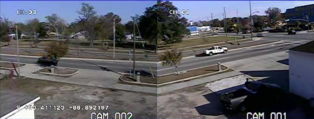
12 Data Collection 26 sites in: Arizona (Flagstaff, Phoenix, Tucson) California (San Leandro, Palo Alto) Texas (Houston, Bryan, College Station) Video

13 Data Reduction Saturation flow rate (SFR) Time each left-turning vehicle crossed stop bar Whether veh is truck or in queue at start of cycle ITE Manual of Transportation Engineering Studies use 7 th, 8 th, 9 th, 10 th vehicle in queue We used 5 th to 10 th vehicle
14
15 Results-Not Significant Variable Lane (inside or outside) Lane Unit Findings Lane 1 (inside lane) Lane 2 (outside lane) SFR Average Count SFR Average Count 1,774 pcphgpl 4,992 passenger cars 1,776 pcphgpl 5,031 passenger cars Both lanes SFR Average 1,775 pcphgpl Count 10,023 passenger cars
16 Results-Not Significant Variable Queue length (5, 6, 7, 8, 9 or 10 vehicles) Saturation Flow (pcphgpl) Number of Vehicles in the Queue
17 Results-Not Significant Variable Left-turn lane width Saturation Flow Rate (pcphgpl) Average Left-Turn Lane Width (ft) Average per LTL Width Average per Site

18 Results-Significant Variable U-turns: each U-turning vehicle decreases SFR by 56 pcphgpl

19 Results-Significant Variable Add lane from channelized right turn Increase SFR by 52 pcphgpl
20 Results-Significant Variable Receiving leg width Saturation Flow Rate (pcphgpl) Average 1725 pcphgpl Average 1833 pcphgpl Receiving Leg Width (at Stop Bar Extension) (ft)
21 Suggested Changes to Green Book Capacity GB approximately 180% This study 196% Receiving leg GB 30 ft used by several agencies Previous study 36 ft desirable, 30 ft acceptable This study supports 36 ft
22 Potential Cautions to add to Green Book U-turning vehicles have a significant impact on operations of double left-turn lanes When receiving leg is 2 lanes plus 3 rd lane due to dedicated downstream lane from channelized right-turn lane left-turning vehicles observed to move into additional lane as soon as physically possible


23 Speed and Deceleration in Left-Turn Lanes at Signalized Intersections Marcus Brewer and Kay Fitzpatrick Texas A&M Transportation Institute Image: Dan Walker

24 Research Objective To recommend improvements to the guidance provided in the AASHTO Green Book for auxiliary lanes at intersections, leading to improved safety and operations. Image: Marcus Brewer
25 Current AASHTO Policy 2011 Green Book, Chapter 9 Speed (mph) Distance (ft) Table 9-22 Figure 9-48
26 Literature Deceleration Rates Fambro, et al (NCHRP Report 400, 1997) 11.2 ft/s 2 for SSD, 24.5 ft/s 2 for maximum/emergency ITE Traffic Engineering Handbook (1999) 11.2 ft/s 2 maximum, up to 10 ft/s 2 reasonably comfortable Gates, et al (2007) Greater than 40 mph: 9.2, 10.9, and 13.6 ft/s 2 Less than 40 mph: 6.4, 8.3, and 11.6 ft/s 2
27 Deceleration Study Questions What is speed differential for turning vehicles? How does speed differential vary based on taper length and/or posted speed limit? Are the 2011 Green Book deceleration rates representative of current left-turn drivers?
28 Deceleration Study Site Selection Controls Taper Length above or below Green Book 8:1 (L:T) for speeds up to 45 mph 96 ft 15:1 (L:T) for speeds 50 mph and above 180 ft Posted Speed Limit (30-65 mph) 4 legs, signalized 4-lane major, 2- or 4-lane minor Straight, level, no skew
29 Study Sites PSL (mph) Taper Length (ft) Below Taper Threshold Above Taper Threshold sites 2 sites sites 2 sites sites site 1 site 3 sites each in Mobile, Tallahassee, Biloxi, and Austin
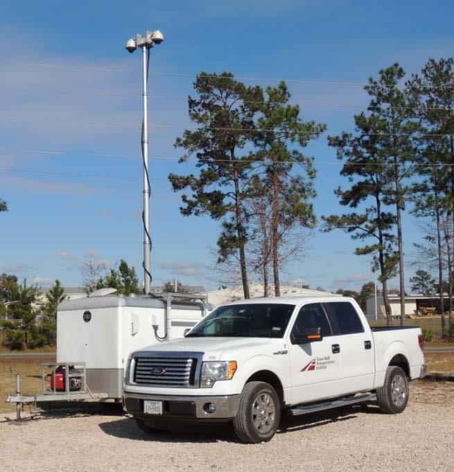
30 Data Collection Image: Debbie Murillo
31 Data Analysis Focus on three key guidelines from Green Book: 10 mph speed differential when the turning vehicle clears the through traffic lane (Note 3 in Table 9-22) 5.8 ft/s 2 average deceleration moving from the through lane into the left-turn lane (Note 4) 6.5 ft/s 2 average deceleration after moving laterally into the left-turn lane (Note 4)
32 Analysis of Speed Differential Observed larger differentials at larger upstream speeds, statistically significant predictor Upstream Speed (mph) # Vehicles with a Speed Differential (mph) of > 30 Total > Total Percent 46% 42% 11% 1% 100%
33 Speed Differential and Green Book No strong statistical relationship between deceleration length and speed differential Deceleration Length (ft) Speed Differential (mph)
34 Deceleration Upstream of Taper About half of observed drivers were 6.1 ft/s 2 or more 85% of highspeed were > 4.2 ft/s 2 Cumulative Distribution 100% 80% 60% 40% 20% 0% mph mph Decel = Deceleration (ft/s 2 )
35 Upstream Decel and Green Book GB guidelines recognize influence of speed, but decel rates/lengths not directly linked Guidelines flexible between 30 and 50 mph and allow consideration of other site characteristics Rate of 4.2 ft/s 2 in taper matches more drivers, especially at high-speed sites Tradeoffs for higher rate/shorter length
36 Deceleration in Decel Lane About half of low-speed drivers and 85% of highspeed were > 6.5 ft/s 2 Cumulative Distribution 100% 80% 60% 40% 20% 0% mph mph Decel = Deceleration (ft/s 2 )
37 Decel Length and Green Book GB: it is not practical to provide full decel length in many locations Most study sites did not have full GB decel length Decel length and vehicle speed were statistically significant 10-ft increase in decel length reduces decel rate by 0.2 ft/s 2
38 Typical Designs Paul Dorothy
39 Case Studies Island design Deceleration lane design Double left-turn lane design Triple left-turn lane design Double right-turn lane design
40 State-of-the-Practice Survey Request for best practice sites for each category (up to 3) 43 recommendations from 6 states
41 Island Design Island defined area between traffic lanes used to control vehicle movements and to provide an area for pedestrian refuge and placement of traffic control devices. Channelized Intersection at-grade intersection in which traffic is directed into definite paths by islands.
42 Island Purpose Separation of conflicts Control of angle conflicts Reduction of excessive pavement areas Regulation of traffic and indication of proper use of intersection
43 Island Purpose Arrangements to favor a predominant turning movement Protection of pedestrians (must consider ADA) Location of traffic control devices Access control

44 Lakewood, Colorado

45 Turning Roadway 5 Components
46 Approach Taper Design speed = 50 mph Recommended taper = 15:1
47 Deceleration Lane Design speed 50 mph Assumes 10 mph decel. occurs in through lane Assumes 15 mph curve Length for 25 mph decel. required Note: A more conservative design may assume stop condition due to ped. crossing.
48 Turning Roadway Curve Angle of Turn (degrees) Design Classificatio n Three-Centered Curve Radii (ft) Offset (ft) Width of Lane (ft) Approximate Island Size (sq ft) A B C A Primarily passenger vehicles: permits occasional design single-unit truck to turn with restricted clearances. B Provides adequately for SU: permits occasional WB-50 to turn with slight encroachment on adjacent traffic lanes. C Provides fully for WB-50 Asymmetric three-centered compound curves and straight tapers with a simple curve can also be used without significantly altering the width of roadway or corner island size. Source: Colorado Roadway Design Guide, Colorado Department of Transportation, 2005 (Updated Nov. 2011). Source: A Policy on the Geometric Design of Highways and Streets, AASHTO, 2004.

49 Acceleration Lane/Merging Taper Configuration 130 ft. full 20-ft width accel. lane 170 ft. taper from 20-ft to 12-ft lane 200 ft. auxiliary lane Total 500 ft. distance provided
50 Large Island (Urban) Source: A Policy on the Geometric Design of Highways and Streets, AASHTO, 2004.
51 Pedestrian Concerns Refuge At-grade or cut-through installations Texture and guidance Logical Clearly delineated

52 Additional Concerns Reduced visibility Snow removal Access control in functional intersection area
53 Deceleration Design Provision for deceleration clear of the throughtraffic lanes is a desirable objective on arterial roads and streets and should be incorporated into design, whenever practical. Green Book

54 Fuquay Varina, North Carolina
55 Intersection West Leg Left- and right-turn deceleration lanes Approach is 2 11-ft. lanes Intersection 4 10-ft. lanes (2 thru, 1 LT, 1 RT)
56 Intersection West Leg 9 ft. symmetric widening about center line Design speed 50 mph Approach taper formula A=WS W = 9 ft. S = 50 mph A = 450 ft.
57 Intersection West Leg 2/3 A = 300 ft. Recommended T = 100 ft. T = 75 ft. used Source: North Carolina Roadway Design Manual, North Carolina Department of Transportation, 2002.
58 Intersection West Leg Source: North Carolina Roadway Standard Drawings, North Carolina Department of Transportation, 2006.
59 Recommended Revisions to AASHTO Green Book Kay Fitzpatrick
60 Disclaimer This presentation represents the authors opinions Material is documented in Appendix A of NCHRP 780 We have provided this material to and have talked with members of the AASHTO Technical Committee on Geometric Design; however, what they will (or will not) include is not currently known
61 9.3.1 Three-Leg Intersections Add discussion about bypass lanes, including a cross-reference to warrants suggested for Section 9.7.3, based on research in NCHRP Report 745 Recommended revisions to some existing diagrams to improve legibility, provide additional detail, and add conflict diagrams
62 9.3.2 Four-Leg Intersections Provide new material to connect to other sections New material regarding skew: where right-of-way is not restricted, all intersecting roadways should meet at a 90-degree angle. where right-of-way is restricted, intersection roadways should meet at an angle of not less than 75 degrees. Several publications support the 75 degree limit
63 9.6.1 Types of Turning Roadways Added material on Channelized Right-Turn Lanes based on NCHRP 3-89 research Crosswalk location Island type Radius of turning roadway Deceleration lanes Acceleration lanes Others
64 9.6.1 Types of Turning Roadways Curb radii should accommodate the expected amount and type of traffic and allow for safe turning speeds at intersections. 15 ft = typically used residential street 25 ft = typically used arterial streets Refuge islands are provided when crossing distance exceeds 60 ft
65 9.6.2 Channelization Added clarity to a bullet Motorists should not be confronted with more than one decision at a time; as such, sufficient median storage should be provided to permit through and left-turning traffic to make a two-stage maneuver.
66 9.6.2 Channelization Remove the use of the term refuge when describing a vehicle storage area so to not confuse that space with space for pedestrians or bicycles Refuge areas for turning vehicles should be provided separate from through traffic. For locations with sufficient turning volumes and/or safety concerns, separate storage lanes should be used to permit turning traffic to wait clear of throughtraffic lanes.
67 9.7.1 General Design Considerations Provided additional guidance / clarity about acceleration lanes Acceleration lanes are advantageous on roads without stop control, particularly those with higher operating speeds and/or higher volumes. Acceleration lanes are not desirable at all-way stop-controlled intersections where entering drivers can wait for an opportunity to merge without disrupting through traffic.
68 9.7.2 Deceleration Lanes P-R Dist, Lane Change/Decel Dist Extensive changes based on recent research (including this project)

69 9.7.2 Deceleration Lanes Taper Length Provide discussion on different approaches for calculating taper length For example: Jurisdictions across the country are increasingly adopting the use of taper lengths such as short as m [ ft] for a single-turn lane and m [ ft] for a dual-turn lane for urban streets.
70 9.7.3 Design Treatments for Left-Turn Maneuvers New material for warrants for leftturn lanes and bypass lanes (based on research documented in NCHRP Report 745) Left-Turn Volume (veh/hr) Rural, Three Legs, Two Lanes on Major Bypass lane warranted Left-turn treatment not warranted Left-turn lane warranted Major Highway Volume (veh/hr/ln)
71 9.7.3 Design Treatments for Left-Turn Maneuvers, Offset Left-Turn From draft Access Management Manual, 2 nd edition (exhibit 17-7)
72 9.7.3 Design Treatments for Left-Turn Maneuvers, Double Multiple left-turn lanes are becoming more widely used at signalized intersections where traffic volumes have increased beyond the design volume of the original single left-turn lane. The following are design considerations for double or triple left-turn lanes: Width of receiving leg. Width of intersection (to accommodate the two or three vehicles turning abreast). Clearance between opposing left-turn movements if concurrent maneuvers are used. Turning path width for design vehicle. Pavement marking visibility. Location of downstream conflict points. Weaving movements downstream of turn. Potential for pedestrian conflict.

73 9.8 Median Openings Provide discussion on differences between bidirectional and directional crossovers
74 9.9.2 Intersections with Jughandle or Loop Roadways Example Graphic for Replacing Green Book Figure Intersection with Jughandle Roadways for Indirect Left Turns From FHWA Signalized Intersections: Informational Guide
75 9.9.3 Displaced Left-Turn Intersections Example Material for New Green Book Table 9-X5. Number of Conflict Points at a Four-Leg Signalized Intersection Compared to a Continuous-Flow Intersection with Displaced Left Turns on the Major Street Only. Four-Leg Continuous Conflict Signalized -Flow type Intersection Intersection Merging/ diverging Crossing 12 6 (left turn) Crossing 4 10 (angle) Total 32 30
76 9.9.4 Wide Medians with U-Turn Crossover Roadways U-turn for indirect left turns with wide median...restricted crossing U- turn intersections
77 9.9.4 Wide Medians with U-Turn Crossover Roadways U-turn for indirect left turns with wide median...restricted crossing U- turn intersections
78 9.9.5 Location and Design of U-Turn Median Openings Figure A-20. Example Graphic for New Green Book Figure 9-XK: Dual U-Turn Directional Crossover Design (part B). Michigan Department of Transportation Geometric Design Guide 670
79 9.10 Roundabout Design New text about: Public outreach Right-turn bypass lanes (slip lanes) Turbo-roundabout concept Accommodating large WB-67 trucks or oversized vehicles
80 QUESTIONS
Left-Turn Lane Design NCHRP Project 3-102
 Left-Turn Lane Design NCHRP Project 3-102 Marcus A. Brewer, P.E. Kay Fitzpatrick, Ph.D., P.E. Texas A&M Transportation Institute Transportation Short Course October 14, 2014 Image: Dan Walker Research
THE FUTURE OF THE TxDOT ROADWAY DESIGN MANUAL
 THE FUTURE OF THE TXDOT ROADWAY DESIGN MANUAL Kenneth Mora, P.E. (Design Division) 10/10/2017 Table of contents 1 2 Reduction in FHWA design controlling criteria Innovative Intersection Guidance 3-7 8-42
Access Management in the Vicinity of Intersections
 Access Management in the Vicinity of Intersections FHWA-SA-10-002 Technical Summary Photo: Ralph Bentley (used with permission) 0 Access Management is: The design, implementation and management of entry
Access Location, Spacing, Turn Lanes, and Medians
 Design Manual Chapter 5 - Roadway Design 5L - Access Management 5L-3 Access Location, Spacing, Turn Lanes, and Medians This section addresses access location, spacing, turn lane and median needs, including
Best Practices for the Design and Operation of Reduced Conflict Intersections
 Best Practices for the Design and Operation of Reduced Conflict Intersections OCTOBER 2016 Prepared By: Table of Contents INTRODUCTION... 5 Purpose... 5 Definition... 5 Advantages... 6 Disadvantages...
Issues Relating to the Geometric Design of Intersections Vergil G. Stover
 Introduction Issues Relating to the Geometric Design of Intersections Vergil G. Stover This paper presents five issues, or topics, that the author suggests be addressed in the design of intersections.
Traffic Engineering and Highway Safety Bulletin June Overview
 Traffic Engineering and Highway Safety Bulletin 18-03 June 2018 INTERSECTION GEOMETRIC DESIGN In This Issue Overview... 1 Intersection Types... 2 Traffic Control Selection... 3 Capacity Analysis... 6 Design
KDOT Access Management Policy (AMP)
") KDOT Access Management Policy (AMP) (January 2013 Edition) Errata KDOT intends to correct these errors during the next revision to the Policy. Corrections are denoted in red text with a solid line through
KDOT Access Management Policy (AMP) (January 2013 Edition) Errata KDOT intends to correct these errors during the next revision to the Policy. Corrections are denoted in red text with a solid line through
Driveway Design Criteria
 Design Manual Chapter 5 - Roadway Design 5L - Access Management 5L-4 Driveway Design Criteria A. General For efficient and safe operations, access drives and minor public street intersections can be improved
2014 FHWA Aging Road User Handbook. Recommendations to Accommodate Aging Pedestrians. Lifesaver National Conference. What is the Handbook?
 2014 FHWA Aging Road User Handbook Recommendations to Accommodate Aging Pedestrians Lifesaver National Conference March 17, 2015 Revised June 2014 1 What is the Handbook? 1998 1st Edition 2001 2nd Edition
Safety Impacts: Presentation Overview
 Safety Impacts: Presentation Overview The #1 Theme How Access Management Improves Safety Conflict Points The Science of Access Management By Treatment Studies Themes for Texas Access Management Improve
Superstreet Concepts & Application. Prepared by: PAPE-DAWSON ENGINEERS, INC. October 16, 2012
 Superstreet Concepts & Application Prepared by: PAPE-DAWSON ENGINEERS, INC. October 16, 2012 1 Purpose of a Superstreet Improve Traffic Flow Increased Safety Economical Solution What is a Superstreet?
INDEX. Geometric Design Guide for Canadian Roads INDEX
 Acceleration lane, see Lanes, Acceleration Access, 8.1 Access Management and Functional Classification 8.2 Access Management by Design Classification 8.3 Access Configuration 8.4 Building Set-Back Guidelines
Modern Roundabouts: a guide for application
 Modern Roundabouts: a guide for application Kentucky Community Transportation Innovation Academy 2005 The contents of this booklet reflect the views of the authors who are responsible for the facts and
Geometric Design Tables
 Design Manual Chapter 5 - Roadway Design 5C - Geometric Design Criteria 5C-1 Geometric Design Tables A. General The following sections present two sets of design criteria tables - Preferred Roadway Elements
Safety Evaluation at Innovative Geometric Designs Gilbert Chlewicki, PE Advanced Transportation Solutions
 2016 ITE Mid-Colonial District Annual Conference Wilmington, Delaware Safety Evaluation at Innovative Geometric Designs Gilbert Chlewicki, PE Advanced Transportation Solutions April 18, 2016 WHY INNOVATIVE
Design of Suburban Highways
 Design of Suburban Highways by David L. Heavey, P.E. TABLE OF CONTENTS Introduction...3 Design Speed, Posted Speed and Operating Speed...4 Median Types...5 Raised Medians...9 Common Suburban Roadway Typical
Innovative Intersections
 Innovative Intersections Things You Need to Know About FDOT D-7 Safety Academy October 19, 2016 Mark Doctor FHWA Resource Center Atlanta, GA HOW DO YOU FEEL??? about innovative intersections??? Why is
CURBSIDE ACTIVITY DESIGN
 5 CURBSIDE ACTIVITY DESIGN This chapter provides design guidance for separated bike lanes adjacent to curbside activities including parking, loading and bus stops. Typical configurations are presented
Figure 1: Graphical definitions of superelevation in terms for a two lane roadway.
 Iowa Department of Transportation Office of Design Superelevation 2A-2 Design Manual Chapter 2 Alignments Originally Issued: 12-31-97 Revised: 12-10-10 Superelevation is the banking of the roadway along
Turn Lane Warrants: Concepts, Standards, Application in Review
 Turn Lane Warrants: Concepts, Standards, Application in Review David J. DeBaie P.E., P.T.O.E. 2004 ITE, District 1 Annual Meeting Burlington, Vermont Introduction Turning lanes at intersections reduce
CHAPTER 1 STANDARD PRACTICES
 CHAPTER 1 STANDARD PRACTICES OBJECTIVES 1) Functions and Limitations 2) Standardization of Application 3) Materials 4) Colors 5) Widths and Patterns of Longitudinal Pavement Marking Lines 6) General Principles
Chapter 2: Standards for Access, Non-Motorized, and Transit
 Standards for Access, Non-Motorized, and Transit Chapter 2: Standards for Access, Non-Motorized, and Transit The Washtenaw County Access Management Plan was developed based on the analysis of existing
CHAPTER 3A. GENERAL PAGE CHAPTER 3B. PAVEMENT AND CURB MARKINGS PAGE
 Virginia Supplement to the 2009 MUTCD Revision 1 Page TC-3-1 PART 3. MARKINGS CHAPTER 3A. GENERAL PAGE Section 3A.01 Functions and Limitations Section 3A.02 Standardization of Application Section 3A.03
Technical Summary Access Management in the Vicinity of Intersections
 Technical Summary Access Management in the Vicinity of Intersections FHWA-SA-10-002 Foreword This technical summary is designed as a reference for State and local transportation officials, Federal Highway
10.0 CURB EXTENSIONS GUIDELINE
 10.0 CURB EXTENSIONS GUIDELINE Road Engineering Design Guidelines Version 1.0 March 2017 City of Toronto, Transportation Services City of Toronto Page 0 Background In early 2014, Transportation Services
General References Definitions. (1) Design Guidance. (2) Supporting Information
 Design Guidance. (2) Supporting Information") Chapter 1240 Turning Roadways 1240.01 General 1240.02 References 1240.03 Definitions 1240.04 Turning Roadway Widths 1240.05 Documentation 1240.01 General The roadway on a curve may need to be widened to
Chapter 1240 Turning Roadways 1240.01 General 1240.02 References 1240.03 Definitions 1240.04 Turning Roadway Widths 1240.05 Documentation 1240.01 General The roadway on a curve may need to be widened to
Roadway Design Manual
 Roadway Design Manual Manual Notice Archive by Texas Department of Transportation (512) 302-2453 all rights reserved Manual Notice 2009-1 From: Manual: Mark A. Marek, P.E Roadway Design Manual Effective
Appendix T CCMP TRAIL TRAFFIC & TRANSPORTATION DESIGN STANDARD
 Appendix T CCMP 3.3.4 TRAIL TRAFFIC & TRANSPORTATION DESIGN STANDARD 3.3.4 Trail Traffic and Transportation Design Multi-use trails have certain design standards, which vary depending on the agency that
Toolbox of Countermeasures and Their Potential Effectiveness to Make Intersections Safer
 8 Toolbox of Countermeasures and Their to Make Intersections Safer Introduction Studies included in the NCHRP 17-18 (3), Guidance for Implementation of the AASHTO Strategic Highway Safety Plan, as well
Designing for Pedestrian Safety. Alabama Department of Transportation Pre-Construction Conference May 2016
 Designing for Pedestrian Safety Alabama Department of Transportation Pre-Construction Conference May 2016 1 Designing for Pedestrians Marking Crosswalks at Signalized intersections High Visibility Markings
Roadway Intersection Design Gregory J. Taylor, P.E.
 Roadway Intersection Design by Gregory J. Taylor, P.E. INTRODUCTION This course summarizes and highlights the geometric design process for modern roadway intersections. This document is intended to explain
The 2012 AASHTO Bike Guide: An Overview
 The 2012 AASHTO Bike Guide: An Overview Presentation by: Jennifer Toole, AICP, ASLA Peter Lagerwey August 10, 2012 {Enter Module Name on Master Slide} WEBINAR #1: OVERVIEW OF 2012 AASHTO BIKE GUIDE Today
Off-road Trails. Guidance
 Off-road Trails Off-road trails are shared use paths located on an independent alignment that provide two-way travel for people walking, bicycling, and other non-motorized users. Trails specifically along
BDC07MR-05. Section 6
 BDC07MR-05 Section 6 6.1 General Most highways intersect at grade. To minimize the resulting conflicts and to provide adequately for the anticipated crossings and turning movements, the geometric design
Alberta Infrastructure HIGHWAY GEOMETRIC DESIGN GUIDE AUGUST 1999
 Alberta Infrastructure HIGHWAY GEOMETRIC DESIGN GUIDE AUGUST 1999,1'(; A ACCELERATION Data on acceleration from stop D-29 Effects of grade D-35 Intersections D-97, D-99 Lanes D-97, F-5, F-7, F-15, F-21,
Access Management Benefits & Techniques. Access Management Workshop June 2, 2006
 Access Management Benefits & Techniques Access Management Workshop June 2, 2006 1 Benefits of Access Management Safety As access density increases, crash rates increase Increasing the density of access
JUNE, 2000 ROAD DESIGN MANUAL 5-0(1) CHAPTER 5 AT-GRADE INTERSECTIONS
 CHAPTER 5 AT-GRADE INTERSECTIONS") JUNE, 2000 ROAD DESIGN MANUAL 5-0(1) CHAPTER 5 AT-GRADE INTERSECTIONS 5-1.0 INTRODUCTION 5-1.01 Definition 5-1.02 Policy 5-1.03 Design Considerations 5-1.04 Vehicle Characteristics 5-1.04.01 Turning Radii
JUNE, 2000 ROAD DESIGN MANUAL 5-0(1) CHAPTER 5 AT-GRADE INTERSECTIONS 5-1.0 INTRODUCTION 5-1.01 Definition 5-1.02 Policy 5-1.03 Design Considerations 5-1.04 Vehicle Characteristics 5-1.04.01 Turning Radii
PEDESTRIAN ACCOMMODATIONS DPS 201 AT INTERCHANGES
 PEDESTRIAN ACCOMMODATIONS DPS 201 AT INTERCHANGES UNDERSTANDING THE ISSUES Intersections of freeway ramp terminals at crossroads are the most critical components of an interchange Challenge: balance mobility
Designing for Pedestrian Safety
 Designing for Pedestrian Safety Intersection Geometry Presented by: John LaPlante T.Y. Lin International, Inc Keith Sinclair FHWA Resource Center September 9, 2010 Learning Outcomes At the end of this
REGIONAL BICYCLE AND PEDESTRIAN DESIGN GUIDELINES
 REGIONAL BICYCLE AND PEDESTRIAN DESIGN GUIDELINES November 16, 2011 Deb Humphreys North Central Texas Council of Governments Bicycle and Pedestrian Advisory Committee Snapshot of the Guide 1. Introduction
Chapter Twenty-eight SIGHT DISTANCE BUREAU OF LOCAL ROADS AND STREETS MANUAL
 Chapter Twenty-eight SIGHT DISTANCE BUREAU OF LOCAL ROADS AND STREETS MANUAL Jan 2006 SIGHT DISTANCE 28(i) Chapter Twenty-eight SIGHT DISTANCE Table of Contents Section Page 28-1 STOPPING SIGHT DISTANCE
TRAFFIC AND SAFETY NOTE 608A. Spacing for Commercial Drives and Streets. To Promote a Uniform Practice in Determining Access Spacing
 TRAFFIC AND SAFETY NOTE 608A SUBJECT: PURPOSE: Spacing for Commercial Drives and Streets To Promote a Uniform Practice in Determining Access Spacing COORDINATING UNIT: Geometric Design Unit INFORMATION:
Section 3A.04 Colors. Section 3B.10 Approach Markings for Obstructions
 Section 3A.04 Colors Markings shall be yellow, white, red, or blue, or purple. The colors for markings shall conform to the standard highway colors. Black in conjunction with one of the above colors shall
IMPROVING PEDESTRIAN SAFETY AT UNCONTROLLED CROSSINGS. Guidelines for Marked Crosswalks
 IMPROVING PEDESTRIAN SAFETY AT UNCONTROLLED CROSSINGS Presented by Nazir Lalani P.E. Traffex Engineers Inc. N_lalani@hotmail.com Guidelines for Marked Crosswalks Source: FHWA, Safety Effects of Marked
A Traffic Operations Method for Assessing Automobile and Bicycle Shared Roadways
 A Traffic Operations Method for Assessing Automobile and Bicycle Shared Roadways A Thesis Proposal By James A. Robertson Submitted to the Office of Graduate Studies Texas A&M University in partial fulfillment
Figure 1: Vicinity Map of the Study Area
 ARIZONA TEXAS NEW MEXICO OKLAHOMA May 5, 2016 Mr. Anthony Beach, P.E. BSP Engineers 4800 Lakewood Drive, Suite 4 Waco, Texas 76710 Re: Intersection and Access Analysis along Business 190 in Copperas Cove
RE: 2007 NPA Text (Clean Version)
") 1 2 3 4 5 6 7 8 9 10 11 12 13 14 15 16 17 18 19 21 20 22 23 24 25 26 27 28 29 30 31 32 33 34 35 36 RE: 2007 NPA Text (Clean Version) P. 230, Lines 29-30 SECTION 3B.04 White Lane Line Pavement Markings
1 2 3 4 5 6 7 8 9 10 11 12 13 14 15 16 17 18 19 21 20 22 23 24 25 26 27 28 29 30 31 32 33 34 35 36 RE: 2007 NPA Text (Clean Version) P. 230, Lines 29-30 SECTION 3B.04 White Lane Line Pavement Markings
Focus of activity - The land near intersections often contains a concentration of travel destinations.
 Chapter 6 Intersection Design 6.1 Introduction An intersection is the area where two or more streets join or cross at-grade. The intersection includes the areas needed for all modes of travel: pedestrian,
400 Intersection Design. Table of Contents. 401 Intersections At-Grade Two Way Left Turn Lanes (TWLTL)... 9
... 9") 4 Intersection Design Table of Contents 41 Intersections At-Grade... 1 41.1 Intersection Locations... 1 41.2 Intersection Traffic Control and Operational Analysis... 1 41.2.1 Signals... 1 41.2.2 Stop Control...
4 Intersection Design Table of Contents 41 Intersections At-Grade... 1 41.1 Intersection Locations... 1 41.2 Intersection Traffic Control and Operational Analysis... 1 41.2.1 Signals... 1 41.2.2 Stop Control...
2.0 LANE WIDTHS GUIDELINE
 2.0 LANE WIDTHS GUIDELINE Road Engineering Design Guidelines Version 2.0.1 May 2018 City of Toronto, Transportation Services City of Toronto Page 0 Background In early 2014, Transportation Services initiated
Defining Purpose and Need
 Advanced Design Flexibility Pilot Workshop Session 4 Jack Broz, PE, HR Green May 5-6, 2010 Defining Purpose and Need In your agency s project development process, when do design engineers typically get
4.1 CONTEXT. The existing terrain and sight conditions will affect available sight lines and approach speeds of bicyclists and motorists.
 4 INTERSECTION DESIGN This chapter provides key principles that should be used to develop and evaluate design approaches and treatments that will result in intersections that support all ages and abilities
Median Design. Course No: C Credit: 4 PDH. Debra Kennaugh, P.E.
 Median Design Course No: C04-041 Credit: 4 PDH Debra Kennaugh, P.E. Continuing Education and Development, Inc. 9 Greyridge Farm Court Stony Point, NY 10980 P: (877) 322-5800 F: (877) 322-4774 info@cedengineering.com
Topic No January 2000 Manual on Uniform Traffic Studies Revised July Chapter 8 GAP STUDY
 Chapter 8 8.1 PURPOSE GAP STUDY (1) The Gap Study is used to determine the size and the number of gaps in the vehicular traffic stream for unsignalized intersections and access points, pedestrian studies,
5. RUNNINGWAY GUIDELINES
 5. RUNNINGWAY GUIDELINES These guidelines should be considered collectively when making runningway decisions. A runningway is the linear component of the transit system that forms the right-of-way reserved
BI-DIRECTIONALS FREE-ACCESS
 BI-DIRECTIONALS FREE-ACCESS Dimensions may vary depending on design vehicle and turning movements. See GEO-650-Series for addtional details. SPECIAL Special situations, i.e., See Notes 4 & 5 wide streets,
PennDOT ICE Policy An Introduction
 PennDOT ICE Policy An Introduction January 2018 What is Intersection Control Evaluation (ICE)? Purpose: To consistently consider and screen among many proven combinations of geometry and traffic control
Design of Turn Lane Guidelines
 Design of Turn Lane Guidelines CTS Transportation Research Conference May 24, 2012 Howard Preston, PE Minnesota Department of Transportation Research Services Office of Policy Analysis, Research & Innovation
CHAPTER 16 PEDESTRIAN FACILITIES DESIGN AND TECHNICAL CRITERIA TABLE OF CONTENTS
 CHAPTER 16 PEDESTRIAN FACILITIES DESIGN AND TECHNICAL CRITERIA TABLE OF CONTENTS Section Title Page 16.1 General... 16-1 16.1.1 AASHTO Reference... 16-1 16.1.2 ADA Requirements... 16-1 16.2 Sidewalks...
Roundabout Design Aid PREPARED BY TRAFFIC AND SAFETY
 Roundabout Design Aid PREPARED BY TRAFFIC AND SAFETY May 2018 Engineering Manual Preamble This manual provides guidance to administrative, engineering, and technical staff. Engineering practice requires
400 Intersection Design
 400 Intersection Design Table of Contents 401 Intersections At-Grade... 4-1 401.1 Intersection Locations... 4-1 401.2 Intersection Traffic Control and Operational Analysis... 4-1 401.2.1 Signals. 4-1 401.2.2
Appendix 3 Roadway and Bike/Ped Design Standards
 Appendix 3 Roadway and Bike/Ped Design Standards OTO Transportation Plan 2040 4/20/2017 Page A3-1 Adopted Standards The adopted OTO Design Standards and Major Thoroughfare Plan are contained herein.
Right and Left Turn Lane Warrants
 Right and Left Turn Lane Warrants TRS 1406 Published April 2014 Introduction The genesis of this project stems from a perception by city and county engineers that there is a lack of guidance relative to
Safety at Unsignalized Intersections. Unsignalized Intersections
 Safety at FHWA Safety Focus Areas 2 National Statistics 3 National Statistics There were 41,059 highway fatalities in 2007. Where did they occur? Non-Intersections 79% About half of all crashes and half
Safety of U-Turns at Unsignalized Median Openings on Urban and Suburban Arterials
 Safety of U-Turns at Unsignalized Median Openings on Urban and Suburban Arterials Ingrid B. Potts Herbert S. Levinson Senior Traffic Engineer Transportation Consultant Midwest Research Institute 40 Hemlock
Intersection Geometric Design
 Course No: C04-033 Credit: 4 PDH Gregory J. Taylor, P.E. Continuing Education and Development, Inc. 9 Greyridge Farm Court Stony Point, NY 10980 P: (877) 322-5800 F: (877) 322-4774 info@cedengineering.com
RIGHT TURNS AT INTERSECTIONS: ARE THERE ALTERNATIVES?
 RIGHT TURNS AT INTERSECTIONS: ARE THERE ALTERNATIVES? R.C. Pyke, J.D. Sampson and K.G. Schmid Stewart Scott International, P O Box 784506, Sandton, 2146 TTT Africa, P.O.Box 109, Sunninghill, G.D.P.T.R.W,
Chapter 8 Chapter 8 VEHICLE GAP STUDY PURPOSE VEHICLE GAP STUDY (FIGURE 8-1)
") Chapter 8 Chapter 8 Formatted: Heading 1 VEHICLE GAP STUDY 5.48.18.1 PURPOSE (1) The Vehicle Gap Study (Form No. 750-020-08) is used to determine the size and the number of gaps in the vehicular traffic
Chapter 8 Chapter 8 Formatted: Heading 1 VEHICLE GAP STUDY 5.48.18.1 PURPOSE (1) The Vehicle Gap Study (Form No. 750-020-08) is used to determine the size and the number of gaps in the vehicular traffic
ROUNDABOUTS/TRAFFIC CIRCLES
 GENERAL 1. Description This standard identifies minimum requirements that shall be met for Roundabouts and Neighborhood Traffic Circles in the design and construction of elements for Arlington County Horizontal
Geometric Design Strategic Research Program
 Geometric Design Strategic Research Program J OINT M EETING OF TRB COMMITTEES ON G EOMETRIC D ESIGN AND O PERATIONAL E FFECTS OF G EOMETRICS and AASHTO TECHNICAL C OMMITTEE ON G EOMETRIC D ESIGN I RVINE,
TRAFFIC LINE MANUAL Edition Revision 1 June 2012 TRAFFIC-ROADWAY SECTION
 TRAFFIC LINE MANUAL 2011 Edition Revision 1 June 2012 TRAFFIC-ROADWAY SECTION TABLE OF CONTENTS Foreword...iv Section A: General Principles A-1 Functions and Limitations... 1 A-2 Colors... 1 A-3 Colored
Truck Climbing Lane Traffic Justification Report
 ROUTE 7 (HARRY BYRD HIGHWAY) WESTBOUND FROM WEST MARKET STREET TO ROUTE 9 (CHARLES TOWN PIKE) Truck Climbing Lane Traffic Justification Report Project No. 6007-053-133, P 101 Ι UPC No. 58599 Prepared by:
Pedestrian Safety at Interchanges
 Countermeasure Strategies for Pedestrian Safety Pedestrian Safety at Interchanges Meghan Mitman Fehr and Peers December 10, 2015 Today s Presentation Introduction and housekeeping Audio issues? Dial into
HCM Sixth Edition. Plus More. Rahim (Ray) Benekohal University of Illinois at Urban Champaign,
 Benekohal University of Illinois at Urban Champaign,") HCM Sixth Edition What s New in the HCM Sixth Edition Plus More Rahim (Ray) Benekohal University of Illinois at Urban Champaign, 65 th Traffic Engineering and Safety Conference October 19 20, 2016 Institute
HCM Sixth Edition What s New in the HCM Sixth Edition Plus More Rahim (Ray) Benekohal University of Illinois at Urban Champaign, 65 th Traffic Engineering and Safety Conference October 19 20, 2016 Institute
133 rd Street and 132 nd /Hemlock Street 132 nd Street and Foster Street MINI ROUNDABOUTS. Overland Park, Kansas
 133 rd Street and 132 nd /Hemlock Street 132 nd Street and Foster Street MINI ROUNDABOUTS Overland Park, Kansas September 1, 2017 TABLE OF CONTENTS 1. INTRODUCTION... 1 2. LITERATURE REVIEW... 1 3. CONCEPT
400 Intersection Design
 400 Intersection Design Table of Contents 401 Intersections At-Grade... 4-1 401.1 Intersection Locations... 4-1 401.2 Intersection Traffic Control and Operational Analysis... 4-1 401.2.1 Signals.4-1 401.2.2
Chapter 5: Crossing the Street
 Chapter 5: Crossing the Street Whether walking or bicycling, a student s journey to school will more than likely require crossing one or more streets. Per the Safe Routes to School Guide, maintained by
Recommended Roadway Plan Section 2 - Land Development and Roadway Access
 Recommended Roadway Plan Section 2 - Land Development and Roadway Access SECTION 2 Land Development and Roadway Access 2.1 Land Use and Access Management The Federal Highway Administration (FHWA) defines
Clear Zone Conflicts in AASHTO Publications
 Clear Zone Conflicts in AASHTO Publications Dick Albin Washington State Department of Transportation Presented at the AASHTO Sub Committee on Design Meeting June 2007 Burlington, Vermont Clear Zone is
WYDOT DESIGN GUIDES. Guide for. Non-NHS State Highways
 WYDOT DESIGN GUIDES Guide for Non-NHS State Highways 2014 GUIDE FOR Non-NATIONAL HIGHWAY SYSTEM (Non-NHS) STATE HIGHWAYS PRESERVATION REHABILITATION RECONSTRUCTION INTRODUCTION This Guide is directed to
Tract or Parcel Project Name PCN Checked By Date
 Tract or Parcel Project Name PCN Checked By Date City of Escondido Public Works Department Signing & Striping Plan Review Checklist The following checklist is a guideline for new CIP and development construction
Figure 3B-1. Examples of Two-Lane, Two-Way Marking Applications
 Figure 3B-1. Examples of Two-Lane, Two-Way Marking Applications A - Typical two-lane, two-way marking with passing permitted in both directions B - Typical two-lane, two-way marking with no-passing zones
REVOCABLE PERMIT FOR STREET BANNER APPLICATION PACKAGE
 Development Engineering 300 Richards Blvd., 3rd Floor Sacramento, CA 95811 Engineering Services Division REVOCABLE PERMIT FOR STREET BANNER APPLICATION PACKAGE Phone: 916-808-8300 Fax: 916-808-1984 Preparation
Implementing Complete Streets in Ottawa. Project Delivery Process and Tools Complete Streets Forum 2015 October 1, 2015
 Implementing Complete Streets in Ottawa October 1, 2015 The Essentials Complete Streets Implementation Framework will become part of the routine delivery of City transportation projects Approach uses every
MUTCD Part 6: Temporary Traffic Control
 MUTCD Part 6: Temporary Traffic Control OMUTCD English units are preferred. OHIO MANUAL OF UNIFORM TRAFFIC CONTROL DEVICES TABLE OF CONTENTS PREFACE INTRODUCTION TABLE OF CONTENTS PART 1. GENERAL Chapter
Considerations in the Review and Approval of a Driveway in Your Jurisdiction
 Considerations in the Review and Approval of a Driveway in Your Jurisdiction So, are you the person at your agency who reviews and approves new driveways? Or, perhaps you are part of the TEAM of people
Grade Separated Intersection
 Grade Separated Intersection Lecture Notes in Transportation Systems Engineering Prof. Tom V. Mathew Contents 1 Overview 1 2 Classification of Intersection 2 2.1 Grade Separated Intersection...........................
GUIDELINES FOR USING DECISION SIGHT DISTANCE AT IGNALIZED INTERSECTIONS NEAR VERTICAL CURVES
 1. Report No. FHWA/TX-05/0-4084-P2 4. Title and Subtitle 2. Government Accession No. 3. Recipient's Catalog No. GUIDELINES FOR USING DECISION SIGHT DISTANCE AT IGNALIZED INTERSECTIONS NEAR VERTICAL CURVES
Attachment No. 13. National Committee on Uniform Traffic Control Devices RWSTC RECOMMENDATION FOLLOWING SPONSOR COMMENTS
 1 2 3 4 Attachment No. 13 5 6 7 8 9 10 11 12 13 14 15 16 17 18 19 20 21 22 23 24 25 26 27 28 29 30 31 32 33 34 35 36 37 38 39 40 41 42 43 RWSTC agenda item IV. 2 June 2011 National Committee on Uniform
Coquitlam Cross-town Bike Route Improving Bicycle Facilities in a Mature Suburban Environment
 Coquitlam Cross-town Bike Route Improving Bicycle Facilities in a Mature Suburban Environment Sarah Rocchi, Vice-President, Projects, Opus International Consultants (Main Presenter) Catherine Mohoruk,
October 2004 REVISIONS (2) SUPERELEVATION DEVELOPMENT 11.3(2)
 SUPERELEVATION DEVELOPMENT 11.3(2)") October 2004 REVISIONS (2) Chapter 11 HORIZONTAL ALIGNMENT SUPERELEVATION DEVELOPMENT 11.3(2) Chapter 12 VERTICAL ALIGNMENT VERTICAL CURVES PASSING SIGHT DISTANCE 12.5(2) VERTICAL CURVES STOPPING SIGHT
October 2004 REVISIONS (2) Chapter 11 HORIZONTAL ALIGNMENT SUPERELEVATION DEVELOPMENT 11.3(2) Chapter 12 VERTICAL ALIGNMENT VERTICAL CURVES PASSING SIGHT DISTANCE 12.5(2) VERTICAL CURVES STOPPING SIGHT
TRAFFIC CALMING PLANNER S PORTFOLIO
 TRAFFIC CALMING PLANNER S PORTFOLIO ISSUE 8 January 2017 PLANNER S PORTFOLIO TRAFFIC CALMING 1 OVERVIEW 2 3 4 ENGINEERED TRAFFIC CALMING MEASURES SIGNS AND PAVEMENT MARKINGS EMERGENCY RESPONSE DELAYS 5
CURB EXTENSIONS BULB OUTS DPS 201 NECKDOWNS
 CURB EXTENSIONS BULB OUTS DPS 201 NECKDOWNS WHY WHEN & WHERE When Limited Sight Distance Pedestrians & Vehicles Vehicles and Signs Want to put two curb ramps in Discourage High speed turning High number
INDUSTRIAL BUILDING 3009 HAWTHORNE ROAD CITY OF OTTAWA TRANSPORTATION OVERVIEW REVISED. Prepared for: Canada Inc.
 INDUSTRIAL BUILDING 3009 HAWTHORNE ROAD CITY OF OTTAWA TRANSPORTATION OVERVIEW REVISED Prepared for: 7849648 Canada Inc. Octiober 1, 2015 114-598 Overview_2.doc D. J. Halpenny & Associates Ltd. Consulting
Report. Typical Sections. City of Middleton, WI
 Report Typical Sections City of Middleton, WI December 2006 Report for City of Middleton, Wisconsin Typical Sections repared by: Traffic Associates LLC and STRAND ASSOCIATES, INC. 910 West Wingra Drive
INTERSECTION DESIGN TREATMENTS
 Designing for Bicyclist Safety INTERSECTION DESIGN TREATMENTS LEARNING OUTCOMES Understand intersection design options and features Select appropriate design feature for a bikeway in a given context C1
GWINNETT COUNTY DEPARTMENT OF TRANSPORTATION
 GWINNETT COUNTY DEPARTMENT OF TRANSPORTATION 1 of 7 June 20, 2007 GENERAL: The following guidelines shall be used in the determination of the requirement for left turn lanes for development projects and
USER GUIDE FOR R1-6 GATEWAY TREATMENT
 USER GUIDE FOR R1-6 GATEWAY TREATMENT FOR PEDESTRIAN CROSSINGS Prepared by: Western Michigan University T.Y. Lin International December 2016 Acknowledgements Michigan Department of Transportation MDOT
Appendix A: Crosswalk Policy
 Appendix A: Crosswalk Policy Appendix A: Crosswalk Policy Introduction This citywide Crosswalk Policy is aimed at improving pedestrian safety and enhancing pedestrian mobility by providing a framework