SPATIAL ANALYSIS OF CRASHES IN LAS CRUCES
|
|
|
- Edmund Kelly
- 5 years ago
- Views:
Transcription

1 SPATIAL ANALYSIS OF CRASHES IN LAS CRUCES

2 Purpose The purpose of this project was to identify and analyze areas within the Las Cruces urbanized area that are experiencing recurring patterns of crashes, specifically those that occur at signalized intersections. Included was analysis of the conditions that might contribute to said crashes. Using the information gained from this study, along with a general understanding of crash trends, we can begin to make recommendations regarding safety needs and improvements to minimize the potential for crashes. The Federal Highway Administration recently released safety performance measure guidelines and this work is part of our effort to comply with those guidelines.
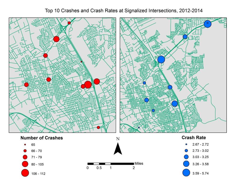
3 Overall Procedure This analysis examines the years 2012, 2013, and The specific areas of the analysis were the 121 signalized intersections located within the Las Cruces urbanized area. Finally, Staff combined the resulting data with the AADT traffic volumes in order to calculate the intersection crash rate. The intersection crash rate is a useful tool examine the relative safety of an intersection beyond just the raw crash total.
4 AADT and Intersection Crash Rate AADT stands for Annual Average Daily Traffic. This is the average volume of traffic flowing over a particular road segment. This is data obtained from the MPO traffic count program Intersection Crash Rate is used to measure the number of crashes controlling for the number of entering vehicles. It is calculated as follows Volume is calculated by the dividing the sum of the AADT s of each of the legs at a particular intersection
5 Terminology Property Damage Only crashes are crashes that involve damage only to any of the vehicle Injury Crashes are crashes that involve personal injury to any of the parties involved Fatal crashes are crashes that result in the death of at least one of the parties involved

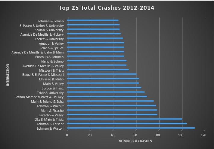
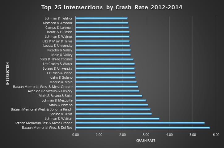
6 Results
7
8
9


10 INTERSECTION Top 25 Property Damage Only Crashes Lohman & Roadrunner Solano & Spruce Boutz & Valley Amador & Valley Missouri & Triviz Avenida De Mesilla & Valley Solano & University Idaho & Solano El Paseo & Union & University Avenida De Mesilla & Idaho & Main Avenida De Mesilla & Hickory Locust & University Boutz & El Paseo & Missouri Main & Valley Bataan Memorial West & Del Rey Lohman & Walnut Spruce & Triviz El Paseo & Idaho Triviz & University Main & Solano & Spitz Picacho & Valley Main & Picacho Lohman & Walton Elks & Main & Triviz Lohman & Telshor NUMBER OF CRASHES

11 INTERSECTION Top 25 Injury Crashes Main & Union Madrid & Main Don Roser & Las Alturas & University Amador & Valley Idaho & Solano El Paseo & Idaho Alameda & El Paseo & Main Solano & Spruce Avenida De Mesilla & Valley Lohman & Solano Triviz & University Boutz & El Paseo & Missouri Missouri & Triviz Spruce & Triviz Amador & Main Amador & Solano Main & Valley Lohman & Telshor Foothills & Lohman Elks & Main & Triviz Picacho & Valley Main & Solano & Spitz Bataan Memorial West & Del Rey Lohman & Walnut Lohman & Walton NUMBER OF CRASHES

12 INTERSECTION Top 25 Fatal Crashes Triviz & University 0 1 NUMBER OF CRASHES


13 INTERSECTION Bicycle Involved Crashes Madrid & Solano 2 Avenida De Mesilla & Calle Del Norte El Paseo & Wyatt Alameda & Picacho Spruce & Triviz Amador & Motel Solano & University Hoagland & Valley Don Roser & Las Alturas & University Lohman & Solano Amador & Main Alameda & Amador Boutz & El Paseo & Missouri Amador & Valley Madrid & Main Main & Union Bamert & Picacho & Shalem Colony Locust & Missouri Idaho & Solano Missouri & Triviz Lohman & Walnut Locust & University Lohman & Walton Alameda & Lohman Stern & Union Alameda & El Paseo & Main NUMBER OF CRASHES Bicycle Involved Crashes Stats and Factors


14 INTERSECTION Pedestrian Involved Crashes Mesquite & Spruce Camino Del Rex & El Camino Real & Main Amador & Campo Solano & University Hoagland & Valley Del Rey & Northrise & Telshor Carver & Main Las Cruces & Water Bataan Memorial West & Del Rey Main & Union Foothills & Lohman Lohman & Roadrunner El Paseo & Idaho Avenida De Mesilla & Hickory Missouri & Triviz Lohman & Walnut Avenida De Mesilla & Valley Lohman & Walton Hadley & Valley Locust & University Pedestrian Involved Crashes Stats and Factors NUMBER OF CRASHES
15 Federal Requirements As of this year, as part of the FAST Act, FHWA now requires State DOTs and MPOs to set Highway Safety Improvement Program (HSIP) targets for 5 safety performance measures: 1. Number of fatalities 2. Rate of fatalities 3. Number of serious injuries 4. Rate of serious injuries 5. Number of non-motorized fatalities and non-motorized serious injuries
16 MPO Tasks MPOs have the option to plan and program projects so they contribute to the accomplishment of State DOT HSIP targets or committing to a quantifiable HSIP target for the MPO area. If an MPO agrees to support State HSIP targets, the MPO would: Work with State and safety stakeholders to address areas of concern Coordinate with the State to include the HSIP performance measures in the MTP Integrate into the metropolitan planning process the performance measures included in all other relevant State documents Include a description in the TIP of the anticipated effect of the TIP toward achieving HSIP targets in the MTP, linking investment priorities in the TIP to the safety targets If an MPO establishes its own HSIP target, the MPO would: Establish HSIP targets for the MPO area Estimate vehicle miles traveled (VMT) for the MPO area Include HSIP performance measures in the MTP Integrate into the metropolitan planning process the performance measures included in all other relevant State documents Include a description in the TIP of the anticipated effect of the TIP toward achieving HSIP targets in the MTP, linking investment priorities in the TIP to the safety targets
17 MPO Tasks MPO Staff must expand the geographic scope of the analysis and will have to apply Vehicle Miles Traveled (VMT) considerations. Over the coming months, the MPO will have to determine whether it will support the NMDOT HSIP target or whether it will establish its own HSIP targets.
18 Questions and Info Tom Murphy, MPO Officer Andrew Wray, Transportation Planner Michael McAdams, Transportation Planner Dominic Loya, Acting Planning Technician Marcus Lopez, Co-Op Cody Sensiba, Co-Op 700 North Main P.O. BOX Las Cruces, NM Phone: (575) For more information about the Transportation Planning Process for the Mesilla Valley MPO:
SAFETY PERFORMANCE MEASURES AND TARGET SETTING. Transportation Subcommittee September 15, 2017
 SAFETY PERFORMANCE MEASURES AND TARGET SETTING Transportation Subcommittee September 15, 2017 ACTION REQUESTED No action is requested. This item is for presentation and discussion. PREVIOUS ACTION Presented
We Count! Summer Report of the Inaugural Annual National Bicycle and Pedestrian Count for Las Cruces
 We Count! Summer 2017 Report of the Inaugural Annual National Bicycle and Pedestrian Count for Las Cruces Prepared by Margaret Brown Vega, Ph.D. and Nathan Craig, Ph.D. for Velo Cruces, Inc. 6 November
Des Moines Area MPO Safety Performance Targets and Methodology
 Des Moines Area MPO Safety Performance Targets and Methodology February 2019 2 P a g e CONTENTS BACKGROUND... 3 Safety Goals in Mobilizing Tomorrow... 3 STATEWIDE TARGETS... 4 DES MOINES AREA MPO SAFETY
MESILLA VALLEY METROP
 METROPOLITAN PLANNING ORGANIZATION SERVING LAS CRUCES, DOÑA ANA COUNTY, AND MESILLA P.O. BOX 20000 LAS CRUCES NM 88004 PHONE (575) 528-3222 FAX (575) 528-3155 http://mesillavalleympo.org MESILLA VALLEY
7/28/2017. Safety Performance Management: Target Setting and Coordination. Agenda. Safety Performance Management (SPM)
") Safety Performance Management: Target Setting and Coordination Stephen Ratke, P.E. Safety Engineer FHWA Texas Division Stephen.Ratke@dot.gov Agenda Safety Performance Management Overview Regulation and
Safety Performance Management: Target Setting and Coordination Stephen Ratke, P.E. Safety Engineer FHWA Texas Division Stephen.Ratke@dot.gov Agenda Safety Performance Management Overview Regulation and
METROPOLITAN PLANNING ORGANIZATION SERVING LAS CRUCES, DOÑA ANA COUNTY, AND MESILLA
 METROPOLITAN PLANNING ORGANIZATION SERVING LAS CRUCES, DOÑA ANA COUNTY, AND MESILLA P.O. BOX 20000 LAS CRUCES NM 88004 PHONE (575) 528-3222 FAX (575) 528-3155 http://mvmpo.las-cruces.org MESILLA VALLEY
PRELIMINARY DRAFT FIRST AMENDMENT TO VISION 2050: A REGIONAL LAND USE AND TRANSPORTATION PLAN FOR SOUTHEASTERN WISCONSIN
 PRELIMINARY DRAFT FIRST AMENDMENT TO VISION 2050: A REGIONAL LAND USE AND TRANSPORTATION PLAN FOR SOUTHEASTERN WISCONSIN ESTABLISHING TARGETS FOR FEDERAL PERFORMANCE MEASURES: HIGHWAY SAFETY SOUTHEASTERN
NMSU Red Light Camera Study Update
 NMSU Red Light Camera Study Update Assessment of Impact of City of Las Cruces Safe Traffic Operations Program on Intersection Traffic Safety Before-and-After Analysis of Crash Data Preliminary Report
Safety Performance Management Target Setting. Data: Fatalities and Serious Injuries
 Safety Performance Management Target Setting Data: Fatalities and Serious Injuries David Adams Georgia DOT Tom Sills CBMPO Executive Summary Purpose of the Regulatory Action is to clarify the Moving Ahead
National Performance Management Measures. April 20, 2016 Webinar
 Safety Performance Measures September 26, 2016 National Performance Management Measures April 20, 2016 Webinar Highway Safety Improvement Program Performance Measures 1 2 3 4 5 Number of fatalities Rate
Attachment One. Integration of Performance Measures Into the Bryan/College Station MPO FY 2019 FY 2022 Transportation Improvement Program
 Attachment One Integration of Performance Measures Into the Bryan/College Station MPO FY 2019 FY 2022 Transportation Improvement Program Introduction Begun as part of the Moving Ahead for Progress in the
Ongoing Challenges with Pedestrian Safety Data May 15: 10:15AM-11:45AM. PedsCount! 2014 May 14-16, 2014 Sacramento, CA
 Ongoing Challenges with Pedestrian Safety Data May 15: 10:15AM-11:45AM PedsCount! 2014 May 14-16, 2014 Sacramento, CA David Ragland, Director, Safe Transportation Research & Education Center (SafeTREC),
Iowa DOT FHWA Safety Targets
 Iowa DOT FHWA Safety Targets August 2018 In January 2018, the Iowa DOT began the process of reviewing data to set performance targets for the five safety performance measures required by FHWA in 23 CFR
We believe the following comments and suggestions can help the department meet those goals.
 The Honorable Secretary Anthony Foxx The Secretary of Transportation United States Department of Transportation 1200 New Jersey Avenue, SE Washington, DC 20590 August 30, 2013 Dear Secretary Foxx, Thank
APPENDIX F. Safety Planning. October 2018
 APPENDIX F Safety Planning October 2018 APPENDIX F: SAFETY PLANNING October 17, 2018 ABOUT VISUALIZE 2045 & THE TPB Visualize 2045 is the federally required long-range transportation plan for the National
METROPOLITAN PLANNING ORGANIZATION SERVING LAS CRUCES, DOÑA ANA COUNTY, AND MESILLA
 METROPOLITAN PLANNING ORGANIZATION SERVING LAS CRUCES, DOÑA ANA COUNTY, AND MESILLA P.O. BOX 20000 LAS CRUCES NM 88004 PHONE (575) 528-3222 FAX (575) 528-3155 http://mvmpo.las-cruces.org MESILLA VALLEY
Safety Corridors a Synthesis. Charlie Nemmers / Derek Vap University of Missouri
 Safety Corridors a Synthesis Charlie Nemmers / Derek Vap University of Missouri 1 Background: Safety Corridors Study Need grew from a four State Safety Summit Funding from Iowa, Kansas, Missouri DOTs and
APPENDIX C. Systems Performance Report C-1
 APPENDIX C Systems Performance Report C-1 System Performance Report & Requirements According to the FAST Act, a long range transportation plan needs to include a system performance report and subsequent
Bi-state metropolitan planning organization (MPO)
") Using a Variety of Data to Identify Locations of Concern in a Transportation Network 3 th Annual MN APA State Planning Conference September, 8 Robert Herling, Planner Duluth-Superior Metropolitan Interstate
Using a Variety of Data to Identify Locations of Concern in a Transportation Network 3 th Annual MN APA State Planning Conference September, 8 Robert Herling, Planner Duluth-Superior Metropolitan Interstate
FHWA s Strategic Agenda for Pedestrian and Bicycle Transportation. Purdue Road School March 8, 2017
 FHWA s Strategic Agenda for Pedestrian and Bicycle Transportation Purdue Road School March 8, 2017 1 Strategic Agenda for Pedestrian and Bicycle Transportation Provides a framework for organizing FHWA
Bike/Multipurpose Trail Study for Glynn County, Georgia MAY 16, 2016
 Bike/Multipurpose Trail Study for Glynn County, Georgia MAY 16, 2016 Agenda» Project Status Update» Draft Recommendations Overview» Next Steps» Questions/Discussion Project Overview» Comprehensive Bikeway
What is the problem? Transportation Safety Planning Purdue Road School. 42,636 Fatalities. Nearly 3M Injuries. Over 4M PDO crashes
 Transportation Safety Planning Purdue Road School March 29, 2006 What is the problem? 42,636 Fatalities Nearly 3M Injuries Over 4M PDO crashes $230B Cost to the Nation Trends in Motor Vehicle Fatality
Analyzing Spatial Patterns, Statistics Based on FAST Act Safety Performance Measures
 Analyzing Spatial Patterns, Statistics Based on FAST Act Safety Performance Measures Abhishek Bhargava, PhD April 13, 2017 Agenda Objective Highway Safety Improvement Program (HSIP) & FAST Act Performance
SAFETY OF OUR STREETS
 SAFETY OF OUR STREETS Assessing Safety Through Crash Data June 216 By analyzing crash data, the Des Moines Area Metropolitan Planning Organization (MPO) is able to help identify areas that tend to be most
Colorado Department of Transportation Crash Data Program Alisa Babler, PE
 Colorado Department of Transportation Crash Data Program Alisa Babler, PE 2014 Colorado 115,388 Total Crashes 39,353 Injuries 488 Fatalities 489.85 100MVMT 88,258 Roadway Center Line Miles Media Question:
Integrating Safety into the Transportation Decision Making Process
 Wednesday, February 17th, 2016 Integrating Safety into the Transportation Decision Making Process Priscilla Tobias, PE State Safety Engineer Illinois Department of Transportation Increased Focus of Safety
AMATS Complete Streets Policy
 AMATS Complete Streets Policy Table of Contents: Section 1. Definition of Complete Streets Section 2. Principles of Complete Streets Section 3. Complete Streets Policy Section 4. Consistency Section 5.
Improving the Process: How Statewide Organizations Are Winning Federal Dollars for Bicycle and Pedestrian Projects
 Improving the Process: How Statewide Organizations Are Winning Federal Dollars for Bicycle and Pedestrian Projects Improving the Process: How Statewide Organizations Are Winning Federal Dollars for Bike-Ped
Bicycle and Pedestrian Planning in a Historically Car-Centric Culture: A Focus on Connectivity, Safety, & Accessibility
 Bicycle and Pedestrian Planning in a Historically Car-Centric Culture: A Focus on Connectivity, Safety, & Accessibility Kate Horton and Zylavian Watley Transportation Planners Memphis MPO Date: October
FMATS Transportation Improvement Program Project Nomination Form
 FMATS 2015 2018 Transportation Improvement Program Project Nomination Form Project nominations are accepted from the public and are scored based on the adopted Project Scoring Criteria. These criteria
Safe Access to Transit:
 Safe Access to Transit: Integrating Transit Operations with Pedestrian and Bicycle Safety and Mobility Best Practices AMPO 2014 October 23, 2014 Presentation Overview Pedestrian (and bicycle) safety problem
Toward Zero Deaths. Regional SHSP Road Show Meeting. Virginia Strategic Highway Safety Plan. presented by
 Toward Zero Deaths Regional SHSP Road Show Meeting presented by Virginia Strategic Highway Safety Plan December 1, 2016 1 Welcome & Introductions Purpose of the Meeting Objectives & Key Outcomes Agenda»
Lane Area Transportation Safety and Security Plan Vulnerable Users Focus Group
 Lane Area Transportation Safety and Security Plan Vulnerable Users Focus Group Agenda 1. Planning Process Review 2. What are Emphasis Areas? 3. Your Role Today 4. Data Review 5. Small group discussion
Pinellas County Metropolitan Planning Organization (MPO) 2014 Crash Data Report
 2014 Crash Data Report") Pinellas County Metropolitan Planning Organization (MPO) 2014 Crash Data Report MPO Board July 8, 2015 2 Crash Data Collection Motorcycle drove between stopped cars, ran a red light and collided with a
Pinellas County Metropolitan Planning Organization (MPO) 2014 Crash Data Report MPO Board July 8, 2015 2 Crash Data Collection Motorcycle drove between stopped cars, ran a red light and collided with a
MULTIMODAL NEEDS ASSESSMENT
 1. ROADWAY INTRODUCTION The roadway network is the backbone of the region s transportation system. While Destino 2045 strives to establish a multi-modal transportation system, the roadway network is still
CE576: Highway Design and Traffic Safety
 CE576: Highway Design and Traffic Safety Predicting Crash Frequency for Two-Lane Rural Highway Segments Cross Sectional Elements Ahmed Abdel-Rahim, Ph.D., P.E. Civil Engineering Department University of
The Traffic Monitoring Guide: Counting Bicyclists and Pedestrians. APBP 2017 June 28: 11:15am-12:45pm
 The Traffic Monitoring Guide: Counting Bicyclists and Pedestrians APBP 2017 June 28: 11:15am-12:45pm 2 Presentation Organization Why count bicyclists and pedestrians? Why report count data? What resources
Bus Rapid Transit on Silicon Valley s El Camino Real: Working Together to Create a Grand Boulevard Steven Fisher
 Bus Rapid Transit on Silicon Valley s El Camino Real: Working Together to Create a Grand Boulevard Steven Fisher Senior Transportation Planner Santa Clara Valley Transportation Authority San Jose, CA How
IOWA HIGHWAY 58 CORRIDOR IMPROVEMENT STUDY PROJECT UPDATE NO. 1 OCTOBER 17, 2013
 IOWA HIGHWAY 58 CORRIDOR IMPROVEMENT STUDY PROJECT UPDATE NO. 1 OCTOBER 17, 2013 INTRODUCTION This web page provides information on the Iowa Highway 58 (IA 58) Corridor Improvement Study in Cedar Falls,
Systemic Safety. Doug Bish Traffic Services Engineer Oregon Department of Transportation March 2016
 Systemic Safety Doug Bish Traffic Services Engineer Oregon Department of Transportation March 2016 Oregon averages 1700 fatal and serious injury crashes each year. Some of the more common crash types include:
FLORIDA STRATEGIC HIGHWAY SAFETY PLAN
 FLORIDA STRATEGIC HIGHWAY SAFETY PLAN 1 FLORIDA STRATEGIC HIGHWAY SAFETY PLAN Presenter: Joe Santos State Safety Engineer FDOT State Safety Office 2 Presentation 3/28/2017 3 FLORIDA STRATEGIC HIGHWAY SAFETY
Welcome. Public Meeting. Heading 1. Heading 2. DeMers Ave. Columbia Rd. Washington St. 42nd St. 32nd Ave. Heading 3 HEADING
 Heading 1 Heading 2 Heading 3 HADING Welcome 4 Heading 5 Normal Normal Less Spacing Public Meeting Normal No Spacing Strong mphasis Intense mphasis To Do List ullet List ullet Last List ullet 2 CÞ List
TEXAS TRAFFIC SAFETY TASK FORCE. Jeff Moseley Texas Transportation Commission
 TEXAS TRAFFIC SAFETY TASK FORCE Jeff Moseley Texas Transportation Commission June 7, 2016 Fatalities and fatal crashes 2010 2015 4,000 3,500 3,417 3,407 3,536 3,533 3,000 3,061 3,067 2,782 2,803 3,037
MONTGOMERY COUNTY PLANNING DEPARTMENT THE MARYLAND-NATIONAL CAPITAL PARK AND PLANNING COMMISSION
 MONTGOMERY COUNTY PLANNING DEPARTMENT THE MARYLAND-NATIONAL CAPITAL PARK AND PLANNING COMMISSION MCPB Item No. 4 Date: 04-17-14 2014 Mobility Assessment Report José Dory, Senior Planner, Functional Planning
PEDESTRIAN/BICYCLIST CRASH ANALYSIS 2015
 PEDESTRIAN/BICYCLIST CRASH ANALYSIS 2015 Central Arkansas Regional Transportation Study Table of Contents Executive Summary... 3 CARTS Pedestrian/Bicycle Crash Analysis... 3 Report Format... 3 Results...
Road Diets: Reconfiguring Streets for Multi-Modal Travel
 Road Diets: Reconfiguring Streets for Multi-Modal Travel Tom Grant, P.E., PTOE What is a Road Diet? Reconfiguration of travel lanes to benefit all roadway users (i.e., Complete Street) Reclaiming the space
ADOT Statewide Bicycle and Pedestrian Program Summary of Phase IV Activities APPENDIX B PEDESTRIAN DEMAND INDEX
 ADOT Statewide Bicycle and Pedestrian Program Summary of Activities APPENDIX B PEDESTRIAN DEMAND INDEX May 24, 2009 Pedestrian Demand Index for State Highway Facilities Revised: May 29, 2007 Introduction
HSIP Project Selection Criteria
 HSIP Project Selection Criteria The purpose of the Highway Safety Improvement Program (HSIP) is to reduce the number of fatal and injury crashes by targeting high crash locations and causes. Projects,
DRIVING ZERO FATALITIES TO A REALITY ILLINOIS LOCAL SAFETY INITIATIVE
 DRIVING ZERO FATALITIES TO A REALITY ILLINOIS LOCAL SAFETY INITIATIVE Priscilla Tobias, PE State Safety Engineer Illinois Dept of Transportation Illinois Stats 102 Counties 145,000 Roadway Miles 900+ Fatalities
1 2 I N T R O D U C T I O 6 G E N E R A L I N F O R M A T I O N. Across. 6. Knowledge communicated in a brief overview
 1 2 I N T R O D U C T I O N 3 4 5 6 G E N E R A L I N F O R M A T I O N 7 Across 6. Knowledge communicated in a brief overview ABBREVIATIONS & ACRONYMS AADT - ANNUAL AVERAGE DAILY TRAFFIC ADT - AVERAGE
SUCCESFUL HSIP APPLICATIONS CUUATS & CHAMPAIGN COUNTY
 SUCCESFUL HSIP APPLICATIONS CUUATS & CHAMPAIGN COUNTY Traffic Engineering and Safety Conference October 15, 2014 CUUATS and Champaign County The Champaign-Urbana Urbanized Area Transportation Study (CUUATS)
FM 1092/Murphy Road Access Management Study Pulic Meeting #1. Wednesday, August 31, :00 p.m. 8:00 p.m.
 FM 1092/Murphy Road Access Management Study Pulic Meeting #1 Wednesday, August 31, 2011 6:00 p.m. 8:00 p.m. Introductions Agency Partners H-GAC Missouri City TxDOT Introductions Consulting Team In Association
DEVELOPMENT OF THE DES MOINES ACCESS MANAGEMENT PLAN
 DEVELOPMENT OF THE DES MOINES ACCESS MANAGEMENT PLAN CTRE Project 03-137 Sponsored by the Iowa Department of Transportation and the Des Moines Area Metropolitan Planning Organization Final Report September
Final Project Prioritization Plan
 Final Project Prioritization Plan For the NM 599 Corridor Executive Summary I. EXECUTIVE SUMMARY NM 599 serves as a North/South by-pass for vehicles traveling through Santa Fe and a WIPP route for low
Guidelines for Integrating Safety and Cost-Effectiveness into Resurfacing, Restoration, and Rehabilitation Projects
 Guidelines for Integrating Safety and Cost-Effectiveness into Resurfacing, Restoration, and Rehabilitation Projects NCHRP Project 15-50 July 2017 1 Research Objective Develop guidelines for safe and cost-effective
Volume Studies CIVL 4162/6162
 Volume Studies CIVL 4162/6162 Lesson Objectives Define critical parameters of interest in traffic volume studies Compute and interpret hourly, daily, weekly, and monthly adjustment factors Collect intersection
7 Complete Streets & Roadway Aesthetics
 7 Complete Streets & Roadway Aesthetics 7.1 OVERVIEW Our streets lay the foundation for how we interface with travel needs, physical exercise, social exchanges and access to goods and services. They are
Welcome to Laredo Metropolitan Transportation Plan First Public Meeting. February 27 th, :30 PM to 7:30 PM. We value your opinion!
 Welcome to Laredo 2015-2040 Metropolitan Transportation Plan First Public Meeting February 27 th, 2014-5:30 PM to 7:30 PM We value your opinion! Todays Objectives Initiate the planning exercise for the
REAL-TIME SYSTEM MANAGEMENT INFORMATION PROGRAM. Routes of Significance Memphis
 REAL-TIME SYSTEM MANAGEMENT INFORMATION PROGRAM Routes of Significance Memphis Introduction - RTSMIP In August 2005 federal legislation was enacted that required a Real-Time System Management Information
Cycling and risk. Cycle facilities and risk management
 Cycling and risk Cycle facilities and risk management Failure to recognize possibilities is the most dangerous and common mistake one can make. Mae Jemison, astronaut 6/11/2010 York Regional Council Cycling
Goal 3: Foster an environment of partnerships and collaboration to connect our communities and regions to one another.
 Non-Motorized Transportation Plan (NMTP) Draft Vision, Goal and,, Tri-County Regional Planning Commission (TCRPC) Purpose The purpose of the Tri-County Regional Planning Commission (TCRPC) Non-Motorized
Development of Criteria to Identify Pedestrian High Crash Locations in Nevada. Quarterly Progress Report. Submitted to
 Development of Criteria to Identify Pedestrian High Crash Locations in Nevada Submitted to Nevada Department of Transportation (NDOT) Research Division 1263 South Stewart Street Carson City, NV 89712 Krishna
Table of Contents Kansas Highway Safety Improvement Program
 KANSAS Page 1 of 54 Table of Contents Table of Contents... 2 Disclaimer... 3 Executive Summary... 4 Introduction... 5 Program Structure... 5 Program Administration... 5 Program Methodology... 8 Project
VDOT BICYCLE & PEDESTRIAN IMPLEMENTATION GUIDE FOR LOCALITY INVOLVEMENT April 2017
 VDOT BICYCLE & PEDESTRIAN IMPLEMENTATION GUIDE FOR LOCALITY INVOLVEMENT April 2017 1 TABLE OF CONTENTS Topic Page(s) About this Guide 3 Encouraging development of bicycle and pedestrian plans by localities
Geometric Categories as Intersection Safety Evaluation Tools
 Geometric Categories as Intersection Safety Evaluation Tools John R. Campbell Ayres Associates N19 W24075 Riverwood Drive, Suite 300 Waukesha, WI 53188 campbellj@ayresassociates.com Keith K. Knapp Engineering
Using GPS Data for Arterial Mobility Performance Measures
 Using GPS Data for Arterial Mobility Performance Measures Paul Czech, MnDOT Shawn Turner, TTI CTS Research Conference May 22, 2014 ~ St. Paul, MN Methodology & Results INRIX GPS Data + = Road Inventory
Section 8. Partnerships and Funding
 This section discusses the potential partnership and funding options that the Town should consider in order to assist with the implementation of the recommendations provided in the Plan. Section 8. Partnerships
Annual Crash Report. Valdosta-Lowndes County Metropolitan Planning Organization
 212-216 Annual Crash Report Valdosta-Lowndes County Metropolitan Planning Organization June 217 1 Contents Introduction... 3 Highway Safety Plan Goals... 4 Other Charts and Data... 16 High Crash Locations...
Appendix T 1: Additional Supporting Data
 Appendix T 1: Additional Supporting Data Project Delivery Delays with the implementation of the 2000 TIP became apparent early in the decade. In response to direction among policy officials, ARC began
Frequently Asked Questions
 Frequently Asked Questions Business US 190 in Copperas Cove From Avenue D to Constitution Drive What is access management? A. Access Management is a growing effort by government agencies to improve how
Performance Criteria for 2035 Long Range Transportation Plan
 Minimizing Impacts on Natural, Historic, Cultural or Archeological Resources 2035 LRTP Weighting Factor: 7% Objective 1.1: Use appropriate planning and design criteria to protect and enhance the built
Texas Strategic Highway Safety Plan Update. 2 nd Emphasis Area Team Meeting Older Road Users 3/7/2017 Austin, TX
 Texas Strategic Highway Safety Plan Update 2 nd Emphasis Area Team Meeting Older Road Users 3/7/2017 Austin, TX Agenda Welcome and introductions (roll call) Review revised strategies Review new data runs
US 69 RELIEF ROUTE STUDY
 US 69 RELIEF ROUTE STUDY Jacksonville, Texas PUBLIC MEETING #2 May 29 th, 2018 Welcome to the public meeting for the US 69 Relief Route Study in Jacksonville. This is the second public meeting for this
How to Develop a Pedestrian Safety Action Plan
 How to Develop a Pedestrian Safety Action Plan Course Introduction Presented by: Peter Eun FHWA RC Safety Engineer Ryan Snyder President, Ryan Snyder Associates, LLC Paul Zykofsky Director, Land Use and
HSM Practitioners Guide to Urban and Suburban Streets. Prediction of Crash Frequency for Suburban/Urban Streets
 HSM Practitioners Guide to Urban and Suburban Streets Prediction of Crash Frequency for Suburban/Urban Streets Predicting Crash Frequency of Suburban/Urban Multilane Streets Learning Outcomes: Describe
Pedestrian Project List and Prioritization
 To: Kyle Wagenschutz, City of Memphis CC: From: Anne Conlon and John Cock, Alta Planning + Design Date: December, 2014 Re: Project List Development (Task 3.1-3.2) and Project List Prioritization (Task
MULTIMODAL NEEDS ASSESSMENT
 5. PORTS OF ENTRY INTRODUCTION The El Paso MPO region is one of the most significant border crossing regions in the United States. Known as the world s largest international border metroplex, traffic and
5. Pedestrian System. Accomplishments Over the Past Five Years
 5. Pedestrian System Accomplishments Over the Past Five Years The Alamo Area Metropolitan Planning Organization (MPO) and its partner agencies recognize the importance of improving pedestrian mobility.
Transportation Safety Planning at DVRPC
 Transportation Safety Planning at DVRPC New York Safety Planning Peer Exchange June 15, 2010 Zoe Neaderland, AICP Manager, Office of Transportation Safety & Congestion Management DVRPC Overview Federally-Designated
Bicycle/Bus Conflict Area Study
 Bicycle/Bus Conflict Area Study Gregory R. Krykewycz, PP, AICP Sr. Transportation Planner Office of Transit, Bicycle, & Pedestrian Planning DVRPC and the regional context Philadelphia s MPO, created in
Phase I-II of the Minnesota Highway Safety Manual Calibration. 1. Scope of Calibration
 TECHNICAL MEMORANDUM Phase I-II of the Minnesota Highway Safety Manual Calibration PREPARED FOR: PREPARED BY: Minnesota Department of Transportation Richard Storm, CH2M HILL Veronica Richfield, CH2M HILL
Stakeholder Communication and Public Involvement Plan
 Stakeholder Communication and Public Involvement Plan Arkansas Statewide Bicycle and Pedestrian Transportation Plan Plan purpose: The Arkansas State Bicycle and Pedestrian Plan will establish a framework
The Pedestrian Safety Action Plan
 The Pedestrian Safety Action Plan Lydia Kelly Bicycle Pedestrian Transportation Planner The San Antonio Bexar County MPO Planning Area and Partners Northeast Partnership Greater Bexar County Council of
City of San Diego Vision Zero Draft Strategic Plan FY 2017
 City of San Diego Vision Zero Draft Strategic Plan FY 2017 Engineering Objective: To develop and implement a strategy that employs best planning, design and engineering practices. Background: Over the
Florida s Intersection Safety Implementation Plan (ISIP)
") Florida Department of TRANSPORTATION Florida s Intersection Safety Implementation Plan (ISIP) Alan El-Urfali, PE State Traffic Engineering and Operations Office March 28, 2017 Intersection Safety Implementation
Florida Department of TRANSPORTATION Florida s Intersection Safety Implementation Plan (ISIP) Alan El-Urfali, PE State Traffic Engineering and Operations Office March 28, 2017 Intersection Safety Implementation
Effects of Traffic Signal Retiming on Safety. Peter J. Yauch, P.E., PTOE Program Manager, TSM&O Albeck Gerken, Inc.
 Effects of Traffic Signal Retiming on Safety Peter J. Yauch, P.E., PTOE Program Manager, TSM&O Albeck Gerken, Inc. Introduction It has long been recognized that traffic signal timing can have an impact
CR 30 / CR 11 and CR 30 / CR 11C Intersection Improvement Project. What Should We Build?
 CR 30 / CR 11 and CR 30 / CR 11C Intersection Improvement Project What Should We Build? Background CR 11 (Timberline) Donath Lake CR 30 CR 11C Stop controlled intersections Currently long delays (several
BIKE & PEDESTRIAN IMPLEMENTATION GUIDE FOR LOCALITY INVOLVEMENT. November 2006
 BIKE & PEDESTRIAN IMPLEMENTATION GUIDE FOR LOCALITY INVOLVEMENT November 2006 1 of 9 TABLE OF CONTENTS Topic Page(s) Encouraging development of Bike and pedestrian plans by localities 3 5 Involving localities
2014 STATE OF THE SYSTEM REPORT
 2014 STATE OF THE SYSTEM REPORT March 2016 This page intentionally left blank System Performance Monitoring This page intentionally left blank System Performance Monitoring State of the System Performance
INDOT Complete Streets Guideline & Policy
 INDOT Complete Streets Guideline & Policy INTRODUCTION The Complete Streets guidelines build upon multiple efforts and promote a multimodal transportation system that is integrated and sustains land use
SR 693 (Pasadena Avenue) Corridor Study from Shore Drive South to 66 th Street
 Corridor Study from Shore Drive South to 66 th Street") Welcome and Introduction Sign-in and comment sheets Restrooms and exits Meeting agenda and timeline Meeting goals / expectations Provide input to guide study recommendations Actively participate throughout
Welcome and Introduction Sign-in and comment sheets Restrooms and exits Meeting agenda and timeline Meeting goals / expectations Provide input to guide study recommendations Actively participate throughout
Pedestrian injuries in San Francisco: distribution, causes, and solutions
 Pedestrian injuries in San Francisco: distribution, causes, and solutions Presentation to the San Francisco Health Commission RAJIV BHATIA, MD, MPH DIRECTOR OF OCCUPATIONAL AND ENVIRONMENTAL HEALTH, SAN
CITY OF SPOKANE VALLEY Request for Council Action
 CITY OF SPOKANE VALLEY Request for Council Action Meeting Date: December 16, 2014 Department Director Approval: Check all that apply: consent old business new business public hearing information admin.
CITY OF FRANKLIN, TENNESSEE. Columbia Avenue. Widening & Improvements Project. Public Meeting May 16, 2017
 CITY OF FRANKLIN, TENNESSEE Columbia Avenue Widening & Improvements Project Public Meeting May 16, 2017 Agenda 6:00 6:30 Formal Presentation 6:30 8:00 Town Hall Forum City of Franklin Columbia Avenue Alternatives
Designing for Pedestrians: An Engineering Symposium. Rutgers University March 21, 2013
 Designing for Pedestrians: An Engineering Symposium Rutgers University March 21, 2013 The Problem 2 Pedestrian Fatalities Pedestrian Fatalities by Year in US (1994-2010) 6000 5000 4000 3000 2000 1000 0
2015 Florida Main Street Annual Conference. Complete Streets Equal Stronger Main Streets
 WHAT ARE COMPLETE STREETS? CASE STUDIES COMPLETING YOUR MAIN STREET 2015 Florida Main Street Annual Conference St. Petersburg, Florida August 19, 2015 WHAT ARE COMPLETE STREETS? CASE STUDIES COMPLETING
Institute of Transportation Engineers Safety Action Plan
 I Institute of Transportation Engineers Safety Action Plan 1. Introduction 2. Intersection Crashes 3. Keep Vehicles on the Road 4. Minimize Consequences When Vehicles Leave the Road 5. School Crossing
Bicycle and Pedestrian Connectivity Study Phase 2
 Connectivity Study Phase 2 Process PROCESS OUTCOMES Phase Prepared By STEP I Public Participation and Outreach 1. RTP Outreach activities, and development of the Bike and Ped Task Force Phase 1 2011 OCPC
Welcome! Urban Work Zone Design. Training Course 0-1
 Welcome! Urban Work Zone Design Training Course 0-1 Instructor Instructor s Name Here 0-2 About This Course This material is based upon work supported by the Federal Highway Administration (FHWA) under
USDOT Bicycle and Pedestrian Safety Initiative: Safer People and Safer Streets. Barbara McCann, USDOT Office of Policy
 { USDOT Bicycle and Pedestrian Safety Initiative: Safer People and Safer Streets Barbara McCann, USDOT Office of Policy 4 Steps from policy to practice Creating multi-modal streets means: 1. Change Decision-Making