HIA Working Group Meeting #5 November 29, 2017
|
|
|
- Polly Hawkins
- 5 years ago
- Views:
Transcription


1 HIA Working Group Meeting #5 November 29, 2017
2 ICEBREAKER
3 Agenda US-1 Corridor Study Update Health Indicator Assessment Update Station Demonstration Area Assessment HIA Recommendations Discussion + Exercise Next Steps
4 Health Impact Assessment What is an HIA? Working with local health partners to understand current health issues Analyze and evaluate how investment in policy, planning, and infrastructure can positively influence health HIA Goals: Improve access to jobs, education, and community services Improve access to healthy foods Improve multimodal mobility Improve safety and convenience for pedestrians & cyclists Support (re)development within the US 1 Corridor
5 Identifying Health Indicators Initial Pathway Diagram (Working Group Meeting #1) Strongest Relationships to Goals and Outcomes Long List Short List Data Availability Primary Final Pathway Diagram
6 Primary Health Indicators Access to Health Care + Healthy Food Mental Health / Depression Chronic Illness (Diabetes, Hypertension, Asthma) Obesity Bicycle + Pedestrian Crash Rates Taxable Land Value
 Obesity Bicycle + Pedestrian Crash Rates Complete Streets Enhanced Transit Taxable")
7 Connecting Indicators to Action Access to Health Care + Healthy Food Mental Health / Depression Chronic Illness (Diabetes, Hypertension, Asthma) Obesity Bicycle + Pedestrian Crash Rates Complete Streets Enhanced Transit Taxable Land Value
8 US 1 Corridor Study Update


9 US-1 Corridor Study Timeline We are Here
10 Purpose Develop a comprehensive plan to implement continuous multimodal facilities that connect the communities along the corridor. Upgrade the existing limited stop service to enhanced transit or Bus Rapid Transit (BRT). Expand transit service north of Palm Beach Gardens to Indiantown Road in Jupiter. Improve public health through transportation design.

11 Complete Streets are designed, built, and maintained to safely and comfortably to serve all modes and people of all ages and abilities Palm Beach TPA Complete Streets Policy adopted in March 2016

 Electric/Hybrid BicycleShare")

 Accessible Access")
12 Enhanced Transit Bicycle Racks on the Bus Better Shelter Design (Public Art, Solar, etc.) Off-Board Ticketing (Smartphone Integration) Electric/Hybrid BicycleShare Racks at Station Free Wi-Fi! Modern Sleek Design Signal Priority Options Real-Time Arrival Information (Smartphone Integration) Accessible Access at all Stops Higher Frequency
13 Project Corridor Limits 42 Miles Camino Real to Indiantown Rd 6 Sections, 14 Cities Section 1: Boca Raton Section 2: Delray Beach, Boynton Beach, Gulf Stream Section 3: Hypoluxo, Lantana, Lake Worth Section 4: West Palm Beach Section 5: Riviera Beach, Lake Park, North Palm Beach Section 6: Juno Beach, Palm Beach Gardens, Jupiter
 75% of transit trip are less than 15 miles Highest Multimodal Use Other than single occupancy vehicle ½ of users are transit")
14 Project Corridor Main Connector Serves the downtown areas in the eastern core of Palm Beach County Distributes People Jobs, homes, neighborhoods, and community destinations 20% of all County jobs Highest Transit Ridership In Palm Beach County (Palm Tran Route 1) 75% of transit trip are less than 15 miles Highest Multimodal Use Other than single occupancy vehicle ½ of users are transit dependent
15 Corridor Stories

16 The Davis s both use automatic wheel chairs and regularly ride Palm Tran along with other connections They live two (2) blocks from the transit stop on 7th Ave They use the bus for everyday activities: bingo, beach, shopping, medical, feeding the ducks, appointments, etc. Mr. Davis has had his wheelchair caught in the train tracks and fell 2 times going across the tracks, breaking his shoulder and hip They use their wheelchairs in the Bicycle lane because of no sidewalk Police have stopped and told them, Get on the sidewalk or I m going to give you a ticket There is no sidewalk

17 Todd is the manager of major hotel property in Downtown West Palm He often directs visitors and hotel guests to locations in and around West Palm Beach He suggests folks should drive over to Palm Beach to see the gorgeous mansions and estate properties along A1A When asked if he would recommend biking to A1A or even other local destinations in Downtown West Palm, he offers, No. Never. [It is unsafe!] When asked again, but considering there could be slower speeds, safer, and more bicycle facilities, he offered, Yes I ve seen it work in other cities

18 Beethoven is a driven entrepreneur confident in the potential of Riviera Beach Relocated from Connecticut, he opened a popular coffee shop, restaurant, and community venue: Kafe Hub He is committed to being part of a renaissance in Riviera Beach and notes, There are a lot of other businesses, like Rybovich [Yacht Services] that would relocate to Riviera Beach if US 1 was more pedestrian friendly Beethoven dreams of more on-street parking and would like a roundabout on 20 th St because it would promote a friendlier, more local businesses environment We need more people to come to Riviera Beach not through

19 Drew grew up in Jupiter, lived in California and Colorado for a while, and returned the area for work which is in North Palm Beach while he lives in Jupiter He thought US 1 has become, a lot more suburban since he left and, it s way more difficult to ride my Bicycle or even walk due to high speeds, driver behavior, and large parking areas Drew reflected, in California and Colorado there was a culture and normalcy of healthy living, especially with biking to work. He, wished that could be the case here Drew noted that walking and cycling is so contagious in California and Colorado, and US 1, has the same potential if it made walking and cycling the priority


20 Example Conceptual Sections Old Dixie Hwy to Gulfstream Blvd

21 Example Plan Layouts Old Dixie Hwy to Gulfstream Blvd Bicycle lane separated by concrete median Green pavement paint used at bicycle/vehicle conflict areas
")


22 Transit Alternatives Blue + Green Boca Raton to Jupiter (Overlapping Service) Green: Boynton Beach to Jupiter Blue: Boca Raton to Riviera Beach Overlap: Boynton Beach to Riviera Beach Blue Boca Raton to Riviera Beach Yellow Boynton Beach and Riviera Beach
23 Alternatives Weekday Service Existing Alt 1 (Blue + Green) Alt 2a (Yellow) Alt 2b (Yellow) Alt 2c (Yellow) Alt 3 (Blue) Route 1 The Bolt Route 1 PTX Route 1 PTX Route 1 PTX Route 1 PTX Route 1 PTX Alignment Boca Raton to Gardens Mall Boca Raton to WPB ITC Same as Existing Boca Raton to Jupiter Same as Existing Boynton Beach to Riviera Beach Same as Existing Boynton Beach to Riviera Beach Same as Existing Boynton Beach to Riviera Beach Same as Existing Boca Raton to Riviera Beach Route Length 42 mi 28 mi 42 mi Blue 33 mi Green 39 mi Total 52 mi 42 mi 19 mi 42 mi 19 mi 42 mi 19 mi 42 mi 33 mi Stop Pairs 172 stops 12 stops 172 stops 45 stops 172 stops 22 stops 172 stops 22 stops 172 stops 22 stops 172 stops 33 stops Headway 20 min 20 min 30 min 20 min (10 min on overlappe d routes) 30 min 20 min 30 min 20 min 20 min 20 min 30 min 20 min Span of Service (am/pm/ night) Revenue Hours Number of Buses 17 hrs 2 hrs (1/1/0) 17 hrs 9 hrs (4/4/1) 17 hrs 9 hrs (4/4/1) 17 hrs 17 hrs 17 hrs 13 hrs 17 hrs 13 hrs
24 Alternatives Model Results Existing Alt 1 (Blue + Green) Alt 2a (Yellow) Alt 2b (Yellow) Alt 2c (Yellow) Alt 3 (Blue) Route 1 The Bolt Route 1 PTX Route 1 PTX Route 1 PTX Route 1 PTX Route 1 PTX Alignment Boca Raton to Gardens Mall Boca Raton to WPB ITC Same as Existing Boca Raton to Jupiter Same as Existing Boynton Beach to Riviera Beach Same as Existing Boynton Beach to Riviera Beach Same as Existing* Boynton Beach to Riviera Beach Same as Existing Boca Raton to Riviera Beach Boardings 7, ,103 1,662 7, , , ,194 1,173 Passengers per Revenue Hour Annual Boardings 1,898,650 23,622 1,804, ,224 1,792, ,376 1,839, ,890 1,976, ,612 1,827, ,815 Annual Operating Cost $5,190,744 $287,274 $3,427,476 $3,922,776 $3,427,476 $1,168,908 $3,427,476 $2,714,244 $5,190,744 $1,842,516 $3,427,476 $3,031,236 Operating Cost per Passenger $2.73 $12.16 $1.90 $9.29 $1.91 $7.50 $1.86 $12.99 $2.63 $9.32 $1.88 $10.18 * Existing Local Route in Alt2c (Yellow) is affected by the Express Route which affects operations & boardings despite maintaining the same service
25 US 1 HIA Update
26 Health Impact Assessment Spring 2017 Summer 2017 Screening 1 Spring- Summer Assessment 3 4 Fall-Winter 2017 Scoping Decision- Making 5 Winter 2017 We are Here # Denotes Working Group Meeting (5) 2018 & Beyond Evaluation & Follow Up Recommendation & Reporting
27 Connecting Indicators to Planning Access to Health Care + Healthy Food Mental Health / Depression Chronic Illness (Diabetes, Hypertension, Asthma) Obesity Bicycle + Pedestrian Crash Rates Complete Streets Enhanced Transit Taxable Land Value
 Lake Worth Depression rate (18.7%) Obesity rate (31.1%) Bicycle/Ped Incident/Mile (3.8) West Palm Beach High transit-dependent households Bicycle/Ped Incident/Mile (3.")
 50% 51% - 75% 76% - 100% Palm Beach Gardens North Palm Beach Lake Park Riviera Beach West Palm Beach Lake Worth")
28 Jupiter Vulnerable Populations Juno Beach Boynton Beach High percentage of racial & ethnic minorities population Food desert Hypertension rate (45.5%) Lake Worth Depression rate (18.7%) Obesity rate (31.1%) Bicycle/Ped Incident/Mile (3.8) West Palm Beach High transit-dependent households Bicycle/Ped Incident/Mile (3.1) Multimodal Split: 10.0% Riviera Beach Hypertension (45.6%) Obesity: 34.1% Asthma: 9.7% Lake Park Obesity: 33.0% Multimodal Split: 9.4% Asthma: 9.3% Concentration of Vulnerable Populations 38% (County Avg) 50% 51% - 75% 76% - 100% Palm Beach Gardens North Palm Beach Lake Park Riviera Beach West Palm Beach Lake Worth Lantana Hypoluxo Boynton Beach Gulf Stream Delray Beach Boca Raton
29 Assessing Indicators Health Indicator Goal Relative Magnitude Impact of Corridor Study Notes Access to Health Care + Healthy Food Increase Medium Moderate Relatively higher effect on transit dependent communities, children, seniors, people with disabilities Mental Health / Depression Decrease Low Low Relatively higher effect on lowincome, transit dependent communities Chronic Illness (Diabetes, Asthma, etc.) Decrease High Moderate Relatively higher effect on transit dependent, and low walkability communities Obesity Rate Decrease Medium Moderate Higher affect on low-income, transit dependent communities Bicycle + Pedestrian Injury / Fatalities Decrease High High High effect corridor-wide on automobile speeds, crossing distances, and lighting Taxable Land Value Balance Medium High Displacement mitigation needed in areas of low land value that may redevelop as part of the study
30 Demonstration Areas

31 Demonstration Areas Demonstration Area Criteria Based on US 1 Multimodal Corridor Study s transit oriented developments (TOD s) Examine vacant and underutilized land No near-term development Vulnerable populations, High-transit dependent population Adjacent to existing or proposed transit Demonstration Area Methodology Evaluate how each health indicator performs Trend scenarios follow current development patterns Sustainability land use and transit grow together


32 Demonstration Areas NE 20 th Street Boca Raton Palm Beach Lake Blvd West Palm Beach West 13 th Street Riviera Beach

33 Demonstration Area US 1 at W 13 th St in Riviera Beach

34 Existing Conditions Street Network + Intersection Density Good Street Network Some Intersection Density

35 Existing Conditions Block Structure Some Large Blocks Typical City Dimensions West Palm Beach, FL Portland, OR

36 Interim Plan Leverage New Streets Re-Stitch Neighborhood Streets Former Smaller Blocks Leverage Movie Theater Site for smaller blocks, development in anticipation of CoastLink Station
37 Interim Plan Leverage Street Network + Intersection Density Increased Neighborhood Connectivity Increased Walkability +9 4-Way Intersections Way Intersections

38 Interim Plan Leverage Block Structure Smaller, walkable blocks Network of green space connecting the Marina to the Transit Locations Green space also acts as stormwater filtration

39 Long-Term Plan ReBuild New Streets TOD Locations Neighborhood Scale Blocks Facilitate Street Crossings with More Intersections Open Space Network
40 Long-Term Plan ReBuild Street Network + Intersection Density Increased Neighborhood Connectivity Increased Walkability +9 4-Way Intersections Way Intersections

41 Long-Term Plan ReBuild Block Structure Smaller, walkable blocks Network of green space connecting the Marina to the Transit Locations Green space also acts as stormwater filtration
42 Health Indicator Assessment US 1 at W 13 th St in Riviera Beach Indicators Economic Development / Redevelopment Quality of Life/Social Cohesion Obesity Rate Metric Scenarios Type Unit Existing Interim Term Long Term Housing density (dwelling unit per acre) Employees (amount) 370 3,400 2,600 Housing units (amount) Public streets linking north-south direction (linear ft) 10,400 11,600 15,100 Public streets linking east-west direction (linear ft) 5,400 6,500 9,300 Peak hour trips generated (traffic volume generated during peak hour) (trips) 630 4,500 3,100 Overall street connectivity (amount of intersections) Publicly accessible parks and open space (acres) Diversity of land use types per building (amt) Diversity of housing types (amt) Average block size (acres) Ability to allow land-use changes (amount of blocks) Average block perimeter (walkability) (linear feet) 2,400 1,800 1,000 Streets w/ ped/bicycle facilites (linear feet) 6,500 9,900 12,100 Streets w/ fronting uses/street trees (linear feet) 0 3,300 9,400 Streets w/ 30 mph or less (amount) Ped/Bicycle Fatality/Injury Percentage of network with high potential for ped/bicycle incidents (no Bicycle lanes, high speeds) Percentage of network with low potential for ped/bicycle incidents (Bicycle lanes, lower speeds) (percentage) 30% 20% 15% (percentage) 70% 80% 85%
43 HIA Recommendations
44 Preliminary Recommendations HIA Goal Areas 1. Access to jobs and education 2. Access to health and community services 3. Improved multimodal mobility 4. Improved safety for pedestrians and cyclists 5. Development / redevelopment along corridor
45 HIA Recommendations Access to Jobs and Education


46 Access to Jobs and Education Recommendation 1a Recommendation Market existing transit connections to/from Florida Atlantic University, Palm Beach State College, and Palm Beach Atlantic Lead Agency Palm Tran Partnering Agencies Colleges Universities

47 Access to Jobs and Education Recommendation 1b Recommendation Locate job training facilities near US 1 transit stops / stations through land use policies Lead Agency Municipalities Partnering Agencies TPA PB County


48 Access to Jobs and Education Recommendation 1c, 1d, & 1e Recommendation Extend bus services hours Leverage on-demand transit Utilize other innovative mobility options to accommodate diverse schedules Lead Agency Palm Tran Municipalities Palm Tran Partnering Agencies PB County Private PB County


49 Access to Jobs and Education Recommendation 1f Recommendation Market existing transit connections between large employers along the corridor Lead Agency Palm Tran Partnering Agencies Private TPA
50 Access to Jobs and Education ID A B Recommendation Market existing transit connections to / from FAU, Palm Beach State College, and Palm Beach Atlantic Locate job training facilities near US 1 transit stops / stations through land use policies Lead Agency Palm Tran Municipalities C Extend bus services hours Palm Tran D Leverage on-demand transit Municipalities E F Utilize other innovative mobility options to accommodate diverse schedules Market existing transit connections between large employers along the corridor Palm Tran Palm Tran Partnering Agencies Colleges Universities TPA Private PB County PB County Private TPA
51 HIA Recommendations Access to Health and Community Services


52 Access to Health and Community Services Recommendation 2a Recommendation Lead Agencies Partnering Agencies Market public transportation to existing health and community services Palm Tran PB County Dept of Health


53 Access to Health and Community Services Recommendation 2b Recommendation Locate a BRT station near Good Samaritan Hospital, Bethesda Hospital, Palm Beach Gardens Medical Center Lead Agency Palm Tran Partnering Agencies TPA PB County Municipalities

54 Access to Health and Community Services Recommendation 2c Recommendation Increase access to healthy foods through coordination with the United Way Food Insecurity Project and other similar efforts Lead Agencies PB County Partnering Agencies United Way Non-Profits


55 Access to Health and Community Services Recommendation 2d Recommendation Develop land use policies to encourage the development of community gardens, food trucks, etc. Lead Agency Municipalities Partnering Agencies TPA Non-Profits
56 Access to Health and Community Services ID Recommendation Lead Agency Partnering Agencies A Market public transportation to existing health and community services Palm Tran PB County Dept of Health B Locate a BRT station near Good Samaritan Hospital, Bethesda Hospital, Palm Beach Gardens Medical Center Palm Tran TPA PB County Municipalities C Increase access to healthy foods through coordination with the United Way Food Insecurity Project and other similar efforts PB County United Way Non-Profits D Develop land use policies to encourage the development of community gardens, food trucks, etc. Municipalities TPA Non-Profits
57 HIA Recommendations Improved Multimodal Mobility

 Lead Agency TPA Partnering Agencies FDOT")
58 Improved Multimodal Mobility Recommendation 3a Recommendation Prioritize sidewalk and crosswalk improvements at station areas and areas with high mobility needs (aging populations, zero-car households) Lead Agency TPA Partnering Agencies FDOT Municipalities Hospitals


59 Improved Multimodal Mobility Recommendation 3b & 3c Recommendation Prioritize level boarding at local bus stops in areas with higher populations of elderly and disabled users Include level boarding at all proposed BRT stations Lead Agency Palm Tran Palm Tran Partnering Agencies FDOT TPA


60 Improved Multimodal Mobility Recommendation 3d Recommendation Adopt a Stop residents / volunteers / frequent travelers to assist with station clean up and information to the transit commuters Lead Agency TPA Partnering Agencies Municipalities


61 Improved Multimodal Mobility Recommendation 3e Recommendation Ensure placement of bicycle racks at bus stops / shelters Lead Agency Municipalities Partnering Agencies Palm Tran


62 Improved Multimodal Mobility Recommendation 3f Recommendation Ensure placement of functional shelters at BRT and high activity local bus stops to provide protection from rain and sun Lead Agency Palm Tran Partnering Agencies Municipalities


63 Improved Multimodal Mobility Recommendation 3g Recommendation Increase marketing of Transit app (real-time transit information) Lead Agency Palm Tran Partnering Agencies Transit
64 Improved Multimodal Mobility ID A B Recommendation Prioritize sidewalk and crosswalk improvements at station areas, especially from BRT stations to health clinics and hospitals Ensure proper wheelchair and stroller access and maneuverability to bus stops/shelters Lead Agency TPA FDOT Partnering Agencies FDOT, Municipalities, Hospitals Palm Tran C Include level boarding at all proposed BRT stations Palm Tran TPA D Adopt a Stop residents / volunteers / frequent travelers to assist with station clean up and information to the transit commuters TPA Municipalities E Ensure placement of Bicycle racks at bus stops / shelters Municipalities Palm Tran F Ensure placement of functional shelters at BRT and high activity transit stop to provide protection from rain and sun Palm Tran Municipalities G Increase marketing of Transit app (real-time transit information) Palm Tran Transit
65 HIA Recommendations Improved Safety


 Lead Agency FDOT Palm")
66 Improved Safety Recommendation 4a Recommendation Provide adequate lighting on road, at bus stops/shelters, and crosswalks (potentially unique lighting identifier on BRT stations) Lead Agency FDOT Palm Tran Partnering Agencies Municipalities


67 Improved Safety Recommendation 4b Recommendation Provide enhanced bicycle strategies near transit stations and intersections Lead Agency FDOT Partnering Agencies Municipalities


68 Improved Safety Recommendation 4c Recommendation Develop marketing and enforcement strategy around crosswalks to promote safe yielding and crossing behavior Lead Agency FDOT Partnering Agencies TPA School Board

 Lead Agency FDOT Partnering Agencies TPA")
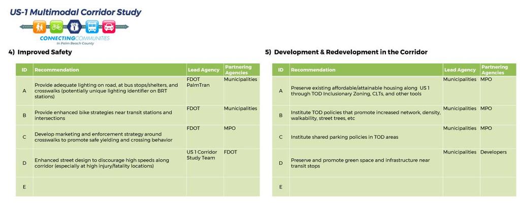
69 Improved Safety Recommendation 4d Recommendation Enhanced street design to discourage high speeds along corridor (especially at high injury/fatality locations) Lead Agency FDOT Partnering Agencies TPA Municipalities
70 Improved Safety ID Recommendation Lead Agency Partnering Agencies A Provide adequate lighting on road, at bus stops/shelters, and crosswalks (potentially unique lighting identifier on BRT stations) FDOT Palm Tran Municipalities B Provide enhanced bicycle strategies near transit stations and intersections FDOT Municipalities C Develop marketing and enforcement strategy around crosswalks to promote safe yielding and crossing behavior FDOT TPA School Board D Enhanced street design to discourage high speeds along corridor (especially at high injury/fatality locations) FDOT TPA Municipalities
71 HIA Recommendations (Re) Development in the Corridor


72 (Re)Development in the Corridor Recommendation 5a Recommendation Preserve existing affordable/attainable housing along US 1 through land use policies like inclusionary zoning, Community Land Trusts, and other tools Lead Agency Municipalities Partnering Agencies TPA PB County


73 (Re)Development in the Corridor Recommendation 5b & 5c Recommendation Institute land use policies that promote increased network, density, walkability, shared parking, etc. at / near BRT stations Create educational programs to help local municipalities implement TOD land use policies Lead Agency Municipalities TPA Partnering Agencies TPA PB County Municipalities PB County


74 (Re)Development in the Corridor Recommendation 5d Recommendation Promote land use policies that include green space, water, and air quality improvements near transit stops Lead Agency Municipalities Partnering Agencies TPA PB County
75 (Re)Development in the Corridor Recommendation 5d ID Recommendation Lead Agency Partnering Agencies A Institute land use policies that promote increased network, density, walkability, shared parking, etc. at / near BRT stations Municipalities TPA PB County B Create educational programs to help local municipalities implement TOD land use policies TPA Municipalities PB County C Institute shared parking policies in TOD areas Municipalities TPA D Promote land use policies that include green space, water, and air quality improvements near transit stops Municipalities TPA PB County
76 Where the Rubber Meets the Road

77 Recommendations Exercise
78 Next Steps Transit Alternative Evaluation with HIA indicators Finalize Recommendations Final Report Monitoring and Evaluation
79 THANK YOU!!!!!
HIA Working Group Meeting #4 September 27, 2017
 HIA Working Group Meeting #4 September 27, 2017 Icebreaker Agenda US-1 Corridor Study Update Health Indicator Assessment Station Demonstration Area Assessment Preliminary Recommendations Discussion Next
Agenda. US-1 Corridor Study and HIA Update. Pathway Diagram / Primary Indicators. Research Questions. Linking Multimodal Improvements to Indicators
 Icebreaker Agenda US-1 Corridor Study and HIA Update Pathway Diagram / Primary Indicators Research Questions Linking Multimodal Improvements to Indicators Vulnerable Populations US-1 Corridor Study Vision
TPA Committee Meetings May 2018
 TPA Committee Meetings May 2018 Purpose Develop a comprehensive plan to identify multimodal improvements for all users of the roadway and evaluate the potential for a premium express bus service Overview
Transit Initiatives 1
 Transit Initiatives 1 TPA Transit Overview Capital Projects Transit Planning Initiatives Challenges Tri-Rail Layover Facility, New Boca Station Northern Layover Facility $28.7 M; Completion in 2023 Boca
DRAFT HEALTH IMPACT ASSESSMENT. PALM BEACH Transportation Planning Agency
 DRAFT HEALTH IMPACT ASSESSMENT PALM BEACH Transportation Planning Agency TABLE OF CONTENTS 5 Executive Summary 11 Introduction 13 What Are Health Impact Assessments? 14 Why Conduct an HIA on US 1? 15
City of Gainesville Transportation/Roadway Needs PROJECT SUMMARY
 A1 Roadway Resurfacing $23,846,000 TYPE: Preservation of existing system Roadway resurfacing A2 Signal Replacement $6,000,000 TYPE: Preservation of existing system Replace traffic signals. B1 W 6th St
Living Streets Policy
 Living Streets Policy Introduction Living streets balance the needs of motorists, bicyclists, pedestrians and transit riders in ways that promote safety and convenience, enhance community identity, create
Perryville TOD and Greenway Plan
 Perryville TOD and Greenway Plan Greenway Glossary Pathway: A bicycle and pedestrian path separated from motorized vehicular traffic by an open space, barrier or curb. Multi-use paths may be within the
2018 Transportation Alternatives Program (TAP) Application Presentation to Palm Beach TPA BRANT BRIDGE CONNECTION LOOP EXTENSION ON CARL BOLTER DR
 Application Presentation to Palm Beach TPA BRANT BRIDGE CONNECTION LOOP EXTENSION ON CARL BOLTER DR") 2018 Transportation Alternatives Program (TAP) Application Presentation to Palm Beach TPA BRANT BRIDGE CONNECTION LOOP EXTENSION ON CARL BOLTER DR Project Location N N Connecting South Delray Beach Existing
2018 Transportation Alternatives Program (TAP) Application Presentation to Palm Beach TPA BRANT BRIDGE CONNECTION LOOP EXTENSION ON CARL BOLTER DR Project Location N N Connecting South Delray Beach Existing
CITY OF COCOA BEACH 2025 COMPREHENSIVE PLAN. Section VIII Mobility Element Goals, Objectives, and Policies
 CITY OF COCOA BEACH 2025 COMPREHENSIVE PLAN Section VIII Mobility Element Goals, Objectives, and Policies Adopted August 6, 2015 by Ordinance No. 1591 VIII MOBILITY ELEMENT Table of Contents Page Number
Project Website: Palm Beach TPA s Website:
 The US-1 Multimodal Corridor Study is a Palm Beach Transportation Planning Agency (TPA) Priority Project that was conducted in 2017-2018 to identify multimodal improvements along US-1 in Palm Beach County
Solana Beach Comprehensive Active Transportation Strategy (CATS)
") Solana Beach Comprehensive Active Transportation Strategy (CATS) 3.0 Goals & Policies The Solana Beach CATS goals and objectives outlined below were largely drawn from the Solana Beach Circulation Element
Solana Beach Comprehensive Active Transportation Strategy (CATS) 3.0 Goals & Policies The Solana Beach CATS goals and objectives outlined below were largely drawn from the Solana Beach Circulation Element
How To Encourage More Efficient Transportation in Brazilian Cities
 How To Encourage More Efficient Transportation in Brazilian Cities Todd Litman Victoria Transport Policy Institute Presented Seminar on Discouraging The Use Of Cars São Paulo, Brazil 3 September 2013 Creating
APPENDIX A: Complete Streets Checklist DRAFT NOVEMBER 2016
 APPENDIX A: Complete Streets Checklist DRAFT NOVEMBER 2016 Complete Streets Checklist MetroPlan Orlando s Complete Streets Checklist is an internal planning tool for staff to further implementation of
ELEMENT 11 TRANSPORTATION ELEMENT
 ELEMENT 11 TRANSPORTATION ELEMENT TRANSIT, CIRCULATION, PARKING, PEDESTRIAN, & NON-VEHICULAR CIRCULATION Introduction The following narrative describes the concepts on which the transportation plan is
NM-POLICY 1: Improve service levels, participation, and options for non-motorized transportation modes throughout the County.
 Transportation PRINCE WILLIAM COUNTY 2008 COMPREHENSIVE PLAN NON-MOTORIZED PLAN CONTENTS Goals, Policies, and Action Strategies Table 4 (Bike Facility Classifications and Descriptions) Table 5 (Bike Facility
In station areas, new pedestrian links can increase network connectivity and provide direct access to stations.
 The Last Mile Planning for Pedestrians Planning around stations will put pedestrians first. Making walking to stations safe and easy is important; walking will be a part of every rapid transit Accessible
Welcome. Background. Goals. Vision
 Welcome The formal Public Information Centre (PIC) for the Transportation Master Plan How We GO will be held in early 2017. At that time we will present the recommended transportation system for Niagara
Sistrunk Corridor DOTMOCRACY SUMMARY
 DOTMOCRACY SUMMARY The TOUCH initiative is a true collaborative working with multi- sector community organizations and agencies to reduce tobacco use and exposure to secondhand smoke, improve access to
Item to be Addressed Checklist Consideration YES NO N/A Required Description Complete Streets Guidelines
 Passaic County Complete Streets Checklist - Concept Development Project Name Item to be Addressed Checklist Consideration YES NO N/A Required Description Complete Streets Guidelines Existing Plans Have
PEDESTRIAN ACTION PLAN
 ATTACHMENT 2 CITY OF SANTA MONICA PEDESTRIAN ACTION PLAN CITY OF SANTA MONICA PEDESTRIAN ACTION PLAN This page intentionally left blank EXECUTIVE SUMMARY CHAPTER 1 EXECUTIVE SUMMARY Setting the Stage
RESOLUTION NO ?? A RESOLUTION OF THE CITY OF NEPTUNE BEACH ADOPTING A COMPLETE STREETS POLICY
 RESOLUTION NO. 2018-?? A RESOLUTION OF THE CITY OF NEPTUNE BEACH ADOPTING A COMPLETE STREETS POLICY WHEREAS, safe, convenient, and accessible transportation for all users is a priority of the City of Neptune
4 MOBILITY PLAN. Mobility Plan Objectives. Mobility Context. 1. Integrate with Local and Regional Transit Improvements
 Harbor Mixed Use CHAPTER Transit Corridor 4: Mobility Plan 4 MOBILITY PLAN Mobility Plan Objectives The Harbor Corridor Plan seeks to expand and improve the ways that people move along and through the
Westgate/Belvedere Homes Community Redevelopment Agency. Belvedere Heights. Streetlights & Sidewalks Improvements Project.
 Westgate/Belvedere Homes Community Redevelopment Agency Belvedere Heights Streetlights & Sidewalks Improvements Project Phase II TPA 2018 Transportation Alternatives Program (TAP) BTPAC Presentation Thursday,
City of Novi Non-Motorized Master Plan 2011 Executive Summary
 City of Novi Non-Motorized Master Plan 2011 Executive Summary Prepared by: February 28, 2011 Why Plan? Encouraging healthy, active lifestyles through pathway and sidewalk connectivity has been a focus
MASTER BICYCLE AND PEDESTRIAN PLAN
 VILLAGE OF NORTHBROOK MASTER BICYCLE AND PEDESTRIAN PLAN DRAFT PLAN OPEN HOUSE May 2, 2018 AGENDA 1. Community Engagement 2. Vision and Goals 3. General Structure of Plan 4. Recommendations Overview 5.
City of Davenport CitiBus Public Transportation Study. April 2015
 City of Davenport CitiBus Public Transportation Study April 2015 Overview Project Background Key Findings CitiBus Service Allocation Policy Discussion 2 Project Background 3 About CitiBus Operates 17 routes
Community Task Force July 25, 2017
 Community Task Force July 25, 2017 Welcome and Introductions Project Partners Regional Transportation District (RTD) Colorado Department of Transportation (CDOT) Denver Regional Council of Governments
Bicycle and Pedestrian Plans and Improvements
 Bicycle and Pedestrian Plans and Improvements Presented to the City Council By Randle Harwood, Planning and Development, and Richard Zavala, Parks and Community Services September 24, 2013 Purpose Review
Downtown Naples Mobility and Connectivity Study. Naples City Council Presentation January 2017
 Downtown Naples Mobility and Connectivity Study Naples City Council Presentation January 2017 Agenda 1. Introduction 2. Scope Review 3. Project Schedule 4. Existing Conditions 5. Public Charrette 6. Mobility
Transit-Driven Complete Streets
 Questions: Type questions into the box at bottom of webinar panel. Panelists for today s webinar: Nimotalai Azeez, Program Associate with the National Complete Streets Coalition Rich Weaver, Director of
We believe the following comments and suggestions can help the department meet those goals.
 The Honorable Secretary Anthony Foxx The Secretary of Transportation United States Department of Transportation 1200 New Jersey Avenue, SE Washington, DC 20590 August 30, 2013 Dear Secretary Foxx, Thank
Cherry Creek Transportation and Land Use Forum September 25, 2013 Meeting Summary
 Cherry Creek Transportation and Land Use Forum September 25, 2013 Meeting Summary I. LEAD-IN TO SMALL GROUP DISCUSSION, POLLING AND STEERING COMMITTEE/TECHNICAL TASK FORCE DISCUSSION The meeting began
Bicycle Master Plan Goals, Strategies, and Policies
 Bicycle Master Plan Goals, Strategies, and Policies Mobilizing 5 This chapter outlines the overarching goals, action statements, and action items Long Beach will take in order to achieve its vision of
CONNECTING PEOPLE TO PLACES
 CONNECTING PEOPLE TO PLACES 82 EAST BENCH MASTER PLAN 07 Introduction The East Bench transportation system is a collection of slow moving, treelined residential streets and major arteries that are the
CHAPTER 7.0 IMPLEMENTATION
 CHAPTER 7.0 IMPLEMENTATION Achieving the vision of the Better Streets Plan will rely on the ability to effectively fund, build and maintain improvements, and to sustain improvements over time. CHAPTER
ACTIVE TRANSPORTATION
 ACTIVE TRANSPORTATION Mobility 2040 Supported Goals Improve the availability of transportation options for people and goods. Support travel efficiency measures and system enhancements targeted at congestion
DRAFT MOVING FORWARD RHODE ISLAND BICYCLE MOBILITY PLAN 2018 PREPARED FOR PREPARED BY IN ASSOCIATION WITH
 RHODE ISLAND MOVING FORWARD BICYCLE MOBILITY PLAN 2018 PREPARED FOR PREPARED BY IN ASSOCIATION WITH T AF CHAPTER 1 D R INTRODUCTION CHAPTER 3 ARTICULATES VISION Bicycling is safe, fun and practical in
Vision. Goals and Objectives. Walking
 Vision Walking and biking is an accepted and valued part of everyday life in Portsmouth. People of all ages and abilities include walking and biking as part of their daily activities which helps to make
Transportation Master Plan Advisory Task Force
 Transportation Master Plan Advisory Task Force Network Alternatives & Phasing Strategy February 2016 BACKGROUND Table of Contents BACKGROUND Purpose & Introduction 2 Linking the TMP to Key Council Approved
Purpose and Need. Chapter Introduction. 2.2 Project Purpose and Need Project Purpose Project Need
 Chapter 2 Purpose and Need 2.1 Introduction The El Camino Real Bus Rapid Transit (BRT) Project (Project) would make transit and other transportation improvements along a 17.6-mile segment of the El Camino
Eliminate on-street parking where it will allow for a dedicated bus only lane %
 Traffic Dashboard Priorities Survey Responses Introduction 1) Are you familiar with bus rapid transit (BRT)? a. No, BRT is new to me. 597 23.5% b. I ve heard of BRT, but I don t know much about it. 1,136
Proposed. City of Grand Junction Complete Streets Policy. Exhibit 10
 Proposed City of Grand Junction Complete Streets Policy Exhibit 10 1 City of Grand Junction Complete Streets Policy Vision: The Complete Streets Vision is to develop a safe, efficient, and reliable travel
Bikeway action plan. Bicycle Friendly Community Workshop March 5, 2007 Rochester, MN
 Bikeway action plan Summary The was held on March 5, 2007 at the Rochester Mayo Civic Center. The workshop was hosted by Rochester-Olmsted County Planning Department in collaboration with the League of
Pocatello Regional Transit Master Transit Plan Draft Recommendations
 Pocatello Regional Transit Master Transit Plan Draft Recommendations Presentation Outline 1. 2. 3. 4. What is the Master Transit Plan? An overview of the study Where Are We Today? Key take-aways from existing
MARKET/JFK VISION ZERO PILOT PROJECT FEBRUARY 2019 EVALUATION REPORT
 MARKET/JFK VISION ZERO PILOT PROJECT FEBRUARY 2019 EVALUATION REPORT WHY IS THIS PROJECT IMPORTANT? Market Street and JFK Boulevard in Center City are key east-west corridors in the core business district.
Proposed White Flint Separated Bike Lane Network September 2015
 Proposed White Flint Separated Bike Lane Network September 2015 Abstract This report includes a proposed separated bike lane network for the White Flint Sector Plan area. Separated bike lanes create a
Performance Criteria for 2035 Long Range Transportation Plan
 Minimizing Impacts on Natural, Historic, Cultural or Archeological Resources 2035 LRTP Weighting Factor: 7% Objective 1.1: Use appropriate planning and design criteria to protect and enhance the built
Bridgewater Complete Streets Prioritization Plan and Pedestrian Safety Assessment
 Bridgewater Complete Streets Prioritization Plan and Pedestrian Safety Assessment Presented by Luciano Rabito Manager of Complete Streets Presented to Bridgewater, MA Wednesday, April 26, 2017 6:30 P.M.
Roads and Vehicular Traffic Design Principles. Roads and Vehicular Traffic Recommendations
 CIRCULATION AND PARKING roads and vehicular traffic The Campus Master Plan updates the campus transportation network through a multi-modal approach that encourages walking and biking while improving vehicular
Afeasibility study to evaluate bus rapid transit service in the East-West Corridor connecting major employment and activity centers between downtown
 East-West Bus Rapid Transit Feasibility Study Update and Recommended Locally Preferred Alternative (LPA) Summary City of Wauwatosa, Transportation Affairs Committee June 2016 Afeasibility study to evaluate
ATTACHMENT 4 - TDM Checklist. TDM Checklist Overview
 ATTACHMENT 4 - TDM Checklist TDM Checklist Overview The proposed checklist rates developments on the degree to which they are TDM and transit supportive. Points are assigned based on the level of transit
Typical Rush Hour Commute. PennyforTransportation.com
 Typical Rush Hour Commute In the News Overview of the Plan Collaborative plan with projects in every community Prioritizing connectivity and congestion relief Dedicated transportation-specific funding;
2015 Florida Main Street Annual Conference. Complete Streets Equal Stronger Main Streets
 WHAT ARE COMPLETE STREETS? CASE STUDIES COMPLETING YOUR MAIN STREET 2015 Florida Main Street Annual Conference St. Petersburg, Florida August 19, 2015 WHAT ARE COMPLETE STREETS? CASE STUDIES COMPLETING
Pinellas County Safety Initiatives
 Florida Department of TRANSPORTATION Pinellas County Safety Initiatives Whit Blanton, FAICP Pinellas County MPO A Distinctive County A unique geography Multi-jurisdictional Key demographics seniors and
Base Information. 1. Project Title SH7/East Arapahoe Multi-Use Path and Transit Stop Improvements. 2. Project Start/End points or Geographic Area
 Part 1 Base Information 1. Project Title SH7/East Arapahoe Multi-Use Path and Transit Stop Improvements 2. Project Start/End points or Geographic Area 38 th /Marine streets to Cherryvale Road (See attached
Omaha s Complete Streets Policy
 Omaha s Complete Streets Policy (Adopted August 2015) VISION To create great places and enhance our quality of life, the City of Omaha will provide safe, accessible streets for all users. Complete Streets
Agenda. Overview PRINCE GEORGE S PLAZA METRO AREA PEDESTRIAN PLAN
 PRINCE GEORGE S PLAZA METRO AREA PEDESTRIAN PLAN May 28, 2008 Agenda Welcome and introductions Project overview and issue identification Planning context and strengths Design challenges and initial recommendations
Chapter 2. Bellingham Bicycle Master Plan Chapter 2: Policies and Actions
 Chapter 2 Bellingham Bicycle Master Plan Chapter 2: Policies and Actions Chapter 2: Policies and Actions The Bicycle Master Plan provides a road map for making bicycling in Bellingham a viable transportation
City of Elizabeth City Neighborhood Traffic Calming Policy and Guidelines
 City of Elizabeth City Neighborhood Traffic Calming Policy and Guidelines I. Purpose: The City of Elizabeth City is committed to ensure the overall safety and livability of residential neighborhoods. One
2. Context. Existing framework. The context. The challenge. Transport Strategy
 Transport Strategy Providing quality connections Contents 1. Introduction 2. Context 3. Long-term direction 4. Three-year priorities 5. Strategy tree Wellington City Council July 2006 1. Introduction Wellington
POLICY AGENDA For Elder Pedestrian Safety
 POLICY AGENDA For Elder Pedestrian Safety Older adults and people with disabilities often have mobility, cognitive, and sensory limitations that affect their behavior as pedestrians and place them at risk
Access BART: TOD and Improved Connections. October 29, 2008
 Access BART: TOD and Improved Connections October 29, 2008 1 Access BART Study Goals Evaluate at the system-level land use and access scenarios to optimize ridership Identify station clusters that provide
Community Task Force March 14, 2018
 Community Task Force March 14, 2018 Welcome and Introductions Project Partners Regional Transportation District (RTD) City of Aurora Colorado Department of Transportation (CDOT) Denver Regional Council
Health Impact Assessment Working Group Meeting #3
 Health Impact Assessment Working Group Meeting #3 January 31, 2018 Casselberry City Hall Multi-Purpose Room Introductions and Icebreaker 2 Agenda SR 436 Transit Corridor Study Update Primary Indicator
CHAPTER 3: Vision Statement and Goals
 Davidson Walks & Rolls: Active Transportation Master Plan CHAPTER 3 Contents: Overview Vision Statement Measurable Goals Public Outreach CHAPTER 3: Vision Statement and Goals Overview The vision statement
Corridor Vision Workshop Summary James Madison Elementary February 22,2018
 Corridor Vision Workshop Summary James Madison Elementary February 22,2018 WHY DEVELOP THIS STUDY? Ogden City is planning for better connectivity and access to jobs and housing. Working with area partners,
1000 FRIENDS OF FLORIDA PALM BEACH COUNTY 2070 OCTOBER 2018
 1000 FRIENDS OF FLORIDA PALM BEACH COUNTY 2070 OCTOBER 2018 HEALTHIER COMMUNITIES & BETTER ECONOMIES THROUGH COMPLETE STREETS PRESENTED BY TREASURE COAST REGIONAL PLANNING COUNCIL The Question of Safety
CONNECTIVITY PLAN. Adopted December 5, 2017 City of Virginia Beach
 CONNECTIVITY PLAN Adopted December 5, 2017 City of Virginia Beach CONTENTS 1.0 Background & Purpose... 2 2.0 Existing Inventory & Analysis... 3 ViBe District Existing Walking Conditions... 4 3.0 ViBe District
Prepared For: Shieldbay Developments Inc. c/o Matson, McConnell Ltd. 2430A Bloor Street West Toronto, Ontario M6S 1P9.
 Prepared For: Shieldbay Developments Inc. c/o Matson, McConnell Ltd. 2430A Bloor Street West Toronto, Ontario M6S 1P9 Prepared By: URS Canada Inc. 4 th Floor, 30 Leek Crescent Richmond Hill, Ontario L4B
Belvedere Heights Streetlights & Sidewalks Improvements Project
 Westgate/Belvedere Homes Community Redevelopment Agency Belvedere Heights Streetlights & Sidewalks Improvements Project Phase I MPO 2017 Transportation Alternatives Program (TAP) BTPAC Special Workshop
Citizen Advocacy. VISION ZERO IN HILLSBOROUGH COUNTY TODAY
 Citizen Advocacy http://www.tampabay.com/news/publicsafety/accidents/car-bus-crash-kills-one/441282 VISION ZERO IN HILLSBOROUGH COUNTY TODAY Does Vision Zero Make Sense Here? Traffic Deaths per 100,000
Welcome. If you have any questions or comments on the project, please contact:
 Welcome This drop-in public open house is intended to provide information about the Bay Street bike lanes project. This project proposes a dedicated cycling facility along Bay Street between Aberdeen Avenue
Classification Criteria
 SCHEDULE D TO RECOMMENDED OFFICIAL PLAN AMENDMENT NO. 40 SCHEDULE C-4 Road Criteria Criteria Traffic Service Objective Land Service/Access Typical Daily Traffic Volume Flow characteristics Travel Speed
PEDESTRIAN ACTION PLAN
 CITY OF SANTA MONICA PEDESTRIAN ACTION PLAN DRAFT OCTOBER 2015 Safe Streets Santa Monica, December 3, 2015 Beth Rolandson, AICP Principal Transportation Planner Strategic + Transportation Planning, Planning
North Coast Corridor:
 North Coast Corridor: Connecting People, Transportation & Environment Legislative Hearing: 11.8.10 1 North Coast Corridor Region s Lifeline A Regional Strategy Mobility, Economy & Environment North Coast
1 PROJECT DESCRIPTION PROBLEM STATEMENT PROJECT PURPOSE AND NEED Study Purpose Study Need... 4
 January 2014 Table of Contents 1 PROJECT DESCRIPTION... 1 2 PROBLEM STATEMENT... 2 3 PROJECT PURPOSE AND NEED... 3 3.1 Study Purpose... 3 3.2 Study Need... 4 4 GOALS AND OBJECTIVES... 9 4.1 Short-term
CPC Parking Lot Riverside Drive. Transportation Rationale
 CPC Parking Lot Transportation Rationale Prepared By: NOVATECH Suite 200, 240 Michael Cowpland Drive Ottawa, Ontario K2M 1P6 September 2015 Novatech File: 114093 Ref: R-2015-153 Table of Contents 1.0 INTRODUCTION...
Progress Table GreenStep HIA Best Practices
 Executive Summary The HIA will guide the City of Marshall and the GreenStep Committee in prioritizing its involvement in the Minnesota GreenStep Cities Program to advance best practices that leverage improving
Planning Regionally With Transit
 Planning Regionally With Transit Nathan Coats Director of Operations CTAA Expo 2015 Tampa Began 1992. Serves eastern Cache County to Preston, ID. Population- 115,000 34 bus fleet, 26 fixed route buses;
Gerald Ollivier Lead Transport Specialist World Bank, New Delhi. Transforming Cities through Integrated Planning Corridor Scale
 Gerald Ollivier Lead Transport Specialist World Bank, New Delhi Transforming Cities through Integrated Planning Corridor Scale JOB ACCESSIBILITY: ZHENGZHOU A: LINE 1, 2, AND 3 AND WALKING: 12% B. SCENARIO
Bus Rapid Transit Plans
 Twin Cities Region Bus Rapid Transit Plans ULI Minnesota Workshop Connecting Bus Rapid Transit to the Community December 15, 2009 John Levin Director of Service Development Metro Transit Metropolitan Area
TRANSPORTATION NEEDS ASSESSMENT
 TRANSPORTATION NEEDS ASSESSMENT A travel demand analysis was carried out to determine the operational issues and the potential benefit that adding traffic capacity would have on the road network. All the
TOWN OF PORTLAND, CONNECTICUT COMPLETE STREETS POLICY
 TOWN OF PORTLAND, CONNECTICUT COMPLETE STREETS POLICY I. VISION, GOALS & PRINCIPLES VISION To improve the streets of Portland making them safer and more accessible for all users including pedestrians,
I-35W Solutions Alliance Project Update July 13, 2017
 Title I-35W Solutions Alliance Project Update July 13, 2017 Evaluating the potential for Bus Rapid Transit and MnPASS Express Lanes in the southwest Metro, Investigating options for improved bus service
15 April CAMPUS MASTER PLAN UPATE F o c us G r o up M o b ility
 15 April 2016 CAMPUS MASTER PLAN UPATE F o c us G r o up M o b ility AGENDA What We Heard Campus Framework & Open Space Network Mobility Approach Supporting the Pedestrian Environment Mobility & Sustainability
Healthy and Environmental Friendly Transport in the City Region
 Healthy and Environmental Friendly Transport in the City Region Reindert Augustijn Team manager traffic and transport Arnhem Nijmegen City Region www.polisnetwork.eu/2014conference #polis14 Fact and figures
North Shore Transportation Improvement Strategy
 North Shore Transportation Improvement Strategy Preliminary, Near-term Recommendation 2016 April Transportation Improvement Strategy (TIS) Comprehensive and Analytical A multi-modal transportation strategy
Sixth Line Development - Transit Facilities Plan
 Memorandum Date: November 13, 2012 To: From: c.c. Subject: Rob Freeman (Freeman Planning) Kevin Phillips Sixth Line Development - Transit Facilities Plan 33016631 This memo was prepared to review the transit
TRAVEL PLAN: CENTRAL EUROPEAN UNIVERSITY CAMPUS REDEVELOPMENT PROJECT TRAVEL PLAN. Central European University Campus Redevelopment Project.
 TRAVEL PLAN Central European University Campus Redevelopment Project Page 1 Table of Contents Introduction... 3 Background... 7 Building Users... 7 Transportation in Community Consultation... 7 Summary
Goal 3: Foster an environment of partnerships and collaboration to connect our communities and regions to one another.
 Non-Motorized Transportation Plan (NMTP) Draft Vision, Goal and,, Tri-County Regional Planning Commission (TCRPC) Purpose The purpose of the Tri-County Regional Planning Commission (TCRPC) Non-Motorized
PEDALING FORWARD. A Glance at the SFMTA s Bike Program for SFMTA.COM
 PEDALING FORWARD A Glance at the SFMTA s Bike Program for 2017-2021 SFMTA.COM INTRODUCTION About This Booklet More people from all walks of life see their bicycle as a more convenient way to get where
Metropolitan Council Transportation Committee
 Nicollet-Central Transit Alternatives Metropolitan Council Transportation Committee August 2013 Project Purpose (approved by Policy Advisory Committee 10/25/2012) The purpose is to improve transit connectivity,
WELCOME. City of Greater Sudbury. Transportation Demand Management Plan
 WELCOME City of Greater Sudbury Transportation Demand Management Plan Public Consultation Session St. Andrew s Place, Activity Hall 111 Larch Street Wednesday September 13, 2017 6:00 to 8:00 pm Welcome
Ann Arbor Downtown Street Plan
 1 Ann Arbor Downtown Street Plan Public Workshop #1 We know that. 2 Public right-of-way (streets, sidewalks, and alleys) make up 30% of the total District area of downtown. Streets need to provide mobility
Pre-Plan Consultation Summary
 Transportation Master Plan Pre-Plan Consultation Summary Thursday July 7, 2011 Presentation ti Outline Consultation Objectives Scope of Consultation Who Responded? What did we hear? How well did we connect?
Chapter 14 PARLIER RELATIONSHIP TO CITY PLANS AND POLICIES. Recommendations to Improve Pedestrian Safety in the City of Parlier (2014)
") Chapter 14 PARLIER This chapter describes the current status and future plans for biking and walking in the City of Parlier. RELATIONSHIP TO CITY PLANS AND POLICIES The Parlier General Plan is the primary
Chapter 14 PARLIER This chapter describes the current status and future plans for biking and walking in the City of Parlier. RELATIONSHIP TO CITY PLANS AND POLICIES The Parlier General Plan is the primary
EL CAMINO REAL BUS RAPID TRANSIT (BRT) PROJECT
 PROJECT") Agenda Item #4.2 EL CAMINO REAL BUS RAPID TRANSIT (BRT) PROJECT VTA BOARD WORKSHOP MAY 1, 2015 ABOUT THIS PRESENTATION CONTEXT Existing conditions and planning for growth WHAT IS THE PROJECT? Project alternatives
Agenda Item #4.2 EL CAMINO REAL BUS RAPID TRANSIT (BRT) PROJECT VTA BOARD WORKSHOP MAY 1, 2015 ABOUT THIS PRESENTATION CONTEXT Existing conditions and planning for growth WHAT IS THE PROJECT? Project alternatives
FINAL PLAN APPENDIX D CITY OF BERKELEY BIKE PLAN D-1
 CITY OF BERKELEY BIKE PLAN D-1 . Proposed Programs D.1. EDUCATION This appendix presents the recommended bicycle-related programs for the City of Berkeley. The recommendations are organized in four E s:
AIRPORT ROAD ENVIRONMENTAL ASSESSMENT
 WELCOME TO PUBLIC INFORMATION CENTRE #1 AIRPORT ROAD ENVIRONMENTAL ASSESSMENT From Braydon Boulevard/Stonecrest Drive to Countryside Drive November 23, 2017 6:30 PM 8:30 PM Please sign in and fill out