San Ramon City Center - City of San Ramon Draft Subsequent EIR Transportation Table (Cont.): Existing Intersection Levels of Service No. Inters
|
|
|
- Cornelia Moody
- 5 years ago
- Views:
Transcription
1
2
3
4
5
6
7 San Ramon City Center - City of San Ramon Draft Subsequent EIR Table (Cont.): Existing Intersection Levels of Service No. Intersection AM Peak Hour PM Peak Hour V/C Ratio LOS V/C Ratio LOS 29 Bollinger Canyon Road/Canyon Lakes Drive 0.59 A 0.55 A Notes: V/C Ratio = Volume to Capacity Ration * = HCM unsignalized intersection analysis Source: DMJM Harris, LOS = Level of Service Freeway Operations The freeway analysis was conducted using 2000 Highway Capacity Manual software for the study section of I-680 north and south of Bollinger Canyon Road. The analysis includes both the freeway mainline and on-and off-ramps to and from Bollinger Canyon Road. The freeway operations analysis included four sections of I-680 at Bollinger Canyon Road: (1) northbound mainline north of the interchange, (2) southbound mainline north of the interchange, (3) northbound mainline south of the interchange, and (4) southbound mainline south of the interchange. A ramp analysis was also completed at five ramps on the I-680 Bollinger interchange: (1) northbound off-ramp, (2) southbound off-ramp, (3) southbound on-ramp, (4) southbound on-ramp (loop), and (5) northbound on-ramp (loop). The northbound on-ramp is analyzed as a roadway because of the auxiliary lane that begins at Bollinger Canyon Road and extends to Crow Canyon Road. Auxiliary lanes are analyzed as weaving sections up to 2,500 feet long. Beyond that length, weaving does not apply. The analysis of a single lane addition, the case for the northbound Bollinger Canyon Road onramp, is simply considered a basic freeway segment with an additional lane. LOS is a quality measure describing operation conditions within a traffic stream, generally in terms of such service measures as speed and travel time, freedom to maneuver, traffic interruptions, and comfort and convenience. Six LOS grades are defined for each type of facility that has analysis procedures available. Letters designate each level, from A to F, with LOS A representing the best operating conditions and LOS F the worst. Each LOS grade represents a range of operating conditions and the driver s perception of those conditions. The LOS for a basic freeway segment is based on density given in units of passenger cars per mile per lane. The LOS thresholds for freeway segments and merge and diverge areas are provided in Table Level of Service Table : Freeway Level of Service Operations Basic Freeway Segment Density Range (pc/mi/ln) Merge and Diverge Areas A Michael Brandman Associates H:\Client (PN-JN)\2491\ \DSEIR\ _Sec04-12.doc
8 San Ramon City Center - City of San Ramon Draft Subsequent EIR Table (Cont.): Freeway Level of Service Operations Level of Service Basic Freeway Segment Density Range (pc/mi/ln) Merge and Diverge Areas B > > C > > D > > E > > 35 F > 45 Demand Exceeds Capacity Notes: pc/mi/hr = passenger cars per mile per hour Source: Highway Capacity Manual, The results of the existing freeway section analysis are provided in Table The results of the ramp analysis are provided in Table South of Bollinger Canyon Road, I-680 operates at level of service F in the southbound direction. South of Bollinger Canyon Road in the northbound direction, the section operates at LOS E. In both directions north of Bollinger Canyon Road, I-680 operates at LOS C and D. The Bollinger Canyon Road/I-680 ramps operate at level of service F in the AM peak hour except the northbound loop on-ramp, which operates at LOS C and the northbound on-ramp, which operates at LOS A. During the PM peak hour the southbound on ramps, both the diagonal and loop ramps operate at LOS F except for the northbound on-ramps, which operate at acceptable levels. Table : Existing Freeway Section Level of Service Direction Northbound Southbound Northbound Southbound Interstate 680 Segment South of Bollinger Canyon Road Interchange South of Bollinger Canyon Road Interchange North of Bollinger Canyon Road Interchange North of Bollinger Canyon Road Interchange Notes: pc/mi/hr = passenger cars per mile per hour *Density and average speed are not determined for LOS F. Source: DMJM Harris, Peak Hour LOS Density (pc/mi/hr) Average Speed AM E PM E AM F * * PM F * * AM C PM C AM D PM D Michael Brandman Associates H:\Client (PN-JN)\2491\ \DSEIR\ _Sec04-12.doc
9 San Ramon City Center - City of San Ramon Draft Subsequent EIR Table : Existing Freeway Ramp Level of Service Interstate 680/Bollinger Canyon Road Interchange Ramp AM Peak Hour PM Peak Hour LOS Density (pc/mi/ln) LOS Density (pc/mi/ln) Northbound Off-Ramp F * C 20.4 Southbound Off-Ramp F * F * Southbound On-Ramp F * F * Southbound On-Ramp (loop) F * F * Northbound On-Ramp (loop) C 27.9 C 26.3 Northbound On-Ramp** A V/C = 0.26 B V/C = 0.45 Notes: pc/mi/hr = passenger cars per mile per hour * Density not determined for LOS F ** Only the volume capacity ratio (V/C) of the ramp is provided because of the auxiliary lane configuration. Source: DMJM Harris, Public Bus Service Central Contra Costa Transit Authority (County Connection) provides transit services in San Ramon, as well as other portions of central Contra Costa County. Exhibit shows the existing transit services in the area. The project site is located about 0.4 mile south of the San Ramon Transit Center, which is located near the intersection of Executive Parkway and Camino Ramon, adjacent to the Iron Horse Trail. Several bus routes serve the transit center and the surrounding area, including Routes 121, 135, 221, 920, 960B, 960C, 970B, and 970C. The routes are briefly described below. Route 121 Route 121 provides local service seven days a week throughout the San Ramon Valley, including the Study Area, between the Walnut Creek Bay Area Rapid Transit (BART) station and the Dublin/Pleasanton BART station. In San Ramon, Route 121 provides service along Camino Ramon and San Ramon Valley Boulevard (paralleling I-680) with deviations along Crow Canyon Road, Bollinger Canyon, Bishop Ranch Business Park and the San Ramon Transit Center. Weekday frequencies on Route 121 are approximately every 30 minutes during peak hours and every 60 minutes during midday and evening hours. Weekend frequencies are every hour. Weekday service begins on Route 121 at approximately 5:15 a.m. and ends at approximately midnight. Saturday service begins at approximately 7:00 a.m. and runs until 10:30 p.m. Sunday service begins at approximately 8:40 a.m. and ends at 6:30 p.m. Employees of businesses that belong to the Bishop Ranch Association ride free on Route 121 with an Express Pass. Route 135 Route 135 provides service between the San Ramon Transit Center and Dublin/Pleasanton BART station via Bollinger Canyon Road and the Dougherty Valley from 6 a.m. to 7 p.m. on weekdays only. During the peak hour, service is provided every 20 minutes and the off-peak hours service is Michael Brandman Associates H:\Client (PN-JN)\2491\ \DSEIR\ _Sec04-12.doc
10 San Ramon City Center - City of San Ramon Draft Subsequent EIR provide every 45 minutes. In addition to a stop at the San Ramon Transit Center, the route includes stops at Sunset Drive and Bollinger Canyon Road at the Market Place. Employees of businesses that belong to the Bishop Ranch Association ride free on Route 135 with an Express Pass. Route 221 Route 221 provides limited peak hour service on weekdays between Alamo and San Ramon. In San Ramon, service is provided on Crow Canyon Road (east of I-680), San Ramon Valley Boulevard (between Crow Canyon Road and Norris Canyon Road) and Annabel Lane in Bishop Ranch. Select trips also travel south of Annabel Lane to serve the San Ramon Transit Center, Alcosta Boulevard, Montevideo Drive and Broadmoor Drive. Morning service on Route 221 begins at approximately 6:00 AM and ends at 8:00 AM. Afternoon service begins at approximately 2:30 PM and ends at 4:00 PM. Route 920 Route 920 operates on weekdays between Walnut Creek (Mitchell Drive park-and-ride lot) and the Altamont Commuter Express (ACE) station in Pleasanton, and from the ACE station to Bishop Ranch. The service runs five times (twice in the morning and three times in the evening) in the southbound direction and six times (three times each in the morning and evening) in the northbound direction. Near the project site, the route stops at the San Ramon Transit Center, at the stop located eastbound at Chevron Park, at eastbound Bishop Ranch 1 south of Bollinger Canyon Road near Camino Ramon, and at the AT&T campus, depending on the direction of travel and peak hour. Employees of businesses that belong to the Bishop Ranch Association ride free on Route 920 with an Express Pass. Routes 960 B/C and 970 B/C Routes 960 B/C and 970 B/C provide express bus service between the Bishop Ranch Business Park and BART stations as part of a long-standing financial agreement between the Bishop Ranch Association (comprised of Sunset Development, Chevron Corporation, and Marriott International). Routes 960 B/C and 970 B/C provide service for commuters traveling to and from the Bishop Ranch Business Park, and Walnut Creek BART station and the Dublin/Pleasanton BART station, respectively. During the peak hours, service is provided every minutes and the offpeak hour s service is provided every 45 minutes. Service is designed to meet every peak hour BART train in the AM and PM hours, beginning at 6:00 a.m. and ending at approximately 8:00 p.m. Employees of businesses that belong to the Bishop Ranch Association ride free on Route 960 B/C and 970 B/C with an Express Pass. Bicycles The Contra Costa Comprehensive Countywide Plan includes pedestrian and bicycle facilities as an important part of meeting the diverse needs of Contra Costa County. Bicycle systems are generally classified using the following classes of bicycle facilities: Michael Brandman Associates H:\Client (PN-JN)\2491\ \DSEIR\ _Sec04-12.doc
11
12
13 San Ramon City Center - City of San Ramon Draft Subsequent EIR Class I (bike path) provides exclusive right-of-way for bicyclists and pedestrians, with cross flows of motorists minimized. Class II (bike lane) provides a restricted right-of-way designated for the exclusive or semiexclusive use of bicycles, with through travel by motor vehicles or pedestrians prohibited but with vehicle parking and cross flows by pedestrians and motorists permitted. Class III (bike route) provides a right-of-way, designated by signs or permanent markings, that is shared by pedestrians and motorists. Table provides a summary of bicycle facilities in central San Ramon. The most notable dedicated bicycle facility is the Iron Horse Trail, which is a mile Class I facility extending from Pleasanton to Concord along the former San Ramon Branch Line right-of-way owned by the County of Contra Costa. Near the project site, Class II facilities, or bike lanes, exist west of Sunset Drive on Bishop Drive, on Alcosta Boulevard, and on San Ramon Valley Boulevard. Bollinger Canyon Road west of San Ramon Valley Boulevard also has Class II bike lanes. East of San Ramon Valley Boulevard, Bollinger Canyon Road becomes a Class III bicycle facility and extends on the south curb of Bollinger Canyon Road to the Iron Horse Trail. Exhibit shows the existing bicycle transportation network near the planned project site. Table : San Ramon Bicycle Facilities Class Roadway/Trail Segment I Iron Horse Trail Entire length of City; trail extends from Pleasanton to Concord (24.47 miles). I Cross Valley Trail Del Mar Drive to Tareyton Avenue. II Crow Canyon Road Alcosta Boulevard to eastern City limits; bike lanes continue into Danville. II San Ramon Valley Boulevard Entire length of City; bike lanes continue into Danville and Dublin. II Norris Canyon Road San Ramon Valley Boulevard to Alcosta Boulevard. II Alcosta Boulevard Crow Canyon Road to Veracruz Drive. II Bollinger Canyon Road Norris Canyon Road to San Ramon Valley Boulevard. II Bollinger Canyon Road Canyon Lakes Drive to Dougherty Road. III Norris Canyon Road San Ramon Valley Boulevard to Bollinger Canyon Road. III Bollinger Canyon Road San Ramon Valley Boulevard to Alcosta Boulevard. III Montevideo Drive San Ramon Valley Boulevard to Alcosta Boulevard. III Alcosta Boulevard Veracruz Drive to San Ramon Valley Boulevard III Broadmoor Drive Montevideo Drive to Alcosta Boulevard. III Davona Drive Montevideo Drive to Alcosta Boulevard. Source: Michael Brandman Associates, Michael Brandman Associates H:\Client (PN-JN)\2491\ \DSEIR\ _Sec04-12.doc
14 San Ramon City Center - City of San Ramon Draft Subsequent EIR Pedestrians Below is a summary of existing sidewalks and paths in the project vicinity. Exhibit shows the pedestrian facilities at the intersections near the project site. Bollinger Canyon Road A sidewalk is present along the south side of Bollinger Canyon Road from the Chevron Park entrance to Alcosta Boulevard. On the north side of the roadway, a sidewalk exists between Central Park and Camino Ramon; there is no sidewalk along the Bishop Ranch 2 frontage. Sidewalks on the north and south side of Bollinger Canyon Road connect with the Iron Horse Trail. The intersection of Bollinger Canyon Road and Camino Ramon/Bishop Ranch 1 entrance road has crosswalks across the west, north, and south legs. The Bollinger Canyon Road intersections with Bishop Ranch 1 East road and Sunset Drive/Chevron Park have crosswalks only across their east and south legs. Camino Ramon A sidewalk is present along the east side of Camino Ramon between Bollinger Canyon Road and Bishop Ranch 3. On the west side of the roadway, a meandering sidewalk extends from Norris Canyon Road to Bishop Drive; there is no sidewalk along the Bishop Ranch 2 frontage. All legs of the Camino Ramon intersection with Bishop Drive have pedestrian crosswalks. Bishop Drive A meandering dirt path is located along the north side of the roadway between Camino Ramon and Executive Parkway. This dirt path includes a par course. A short segment of sidewalk is located along the south side of the roadway between Camino Ramon and a Bishop Ranch 2 driveway; however, it does not extend the full length of the Bishop Ranch 2 frontage. All legs of the Bishop Drive intersection with Sunset Drive have pedestrian crosswalks. Sunset Drive A sidewalk is present along the east side of Sunset Drive between Bollinger Canyon Road and Bishop Drive along the Bishop Ranch 2 frontage. On the west side, a sidewalk extends between the Shops at Bishop Ranch entrance and Bishop Drive; no sidewalk is present between Bollinger Canyon Road and the Shops at Bishop Ranch entrance. All legs of the Sunset Drive intersection with the Shops at Bishop Ranch/Bishop Ranch 2 entrance have pedestrian crosswalks. Bishop Ranch 1 Entrance Road Sidewalks are present on both sides of the Bishop Ranch 1 entrance road and extend between Bollinger Canyon Road and the Bishop Ranch 1 office complex Michael Brandman Associates H:\Client (PN-JN)\2491\ \DSEIR\ _Sec04-12.doc
15
16
17
18
19 San Ramon City Center - City of San Ramon Draft Subsequent EIR Bishop Ranch 1 East Road A sidewalk extends along the full length of the west side of the Bishop Ranch 1 East road. No sidewalk is present on the east side of the road. There are crosswalks linking the sidewalk with the Iron Horse Trail. Demand Management Demand Management (TDM) is a series of measures promoting alternatives to the single-occupant vehicle for reducing traffic congestion and improving air quality by maximizing the use of the existing transportation infrastructure. These measures include carpooling, vanpooling, transit, walking, bicycling, telecommuting, and compressed workweeks. The City of San Ramon s TDM program was originally established in Over the years, the program has evolved into one of three regional TDM programs known as 511 Contra Costa. The City provides administrative oversight and implements the 511 Southern Contra Costa County TDM programs. The primary goal of the City s Employer TDM program is to reduce traffic congestion and improve air quality through the reduction of work-related car trips. As part of this endeavor, the City facilitates a TDM Advisory Committee, which is responsible for the following: Coordinating and monitoring the implementation of the regional and Citywide TDM efforts in order to achieve reductions in employment-related, single-occupant vehicle traffic. Providing recommendations to the City Council regarding improvements in City services and facilities to assist employers in reducing single-occupant vehicles. Developing and implementing commute alternative programs in concert with 511 Contra Costa and the Contra Costa Authority. Coordinating TDM efforts with all employers and complexes in the City. Coordinating TDM efforts with local and regional agencies as designated by the City. Serving as liaison between the City and business community. The Bishop Ranch Association has been an active member of the City s TDM program since the program s inception. Bishop Ranch has been recognized multiple times at the local, regional, State, and federal levels for its leadership and contribution to reducing the number of single-occupant vehicles and for encouraging commuters to carpool, ride transit, vanpool, walk, and bicycle to work. Bishop Ranch also continues to create and implement unique, creative, and successful TDM strategies that improve air quality by significantly reducing traffic congestion. Since 1989, the City has collected data related to commute patterns from businesses throughout the City, including the Bishop Michael Brandman Associates H:\Client (PN-JN)\2491\ \DSEIR\ _Sec04-12.doc
20 San Ramon City Center - City of San Ramon Draft Subsequent EIR Ranch Business Park. Over the years, the survey data has included information and survey results from Bishop Ranch Business Park and the City of San Ramon. The most recent survey in 2006, which had a response rate of 38 percent, found that 24.3 percent of Bishop Ranch employees used an alternative form of transportation instead of driving alone. The survey results are below: Drive alone: 68.8 percent Carpool: 9.5 percent Vanpool: 3.3 percent Bus: 2.5 percent BART and bus: 2.4 percent Telecommute: 2.2 percent Compressed day off: 1.7 percent ACE: 0.9 percent Bicycle: 1.2 percent Motorcycle: 0.6 percent Walk: 0.6 percent Note that responses were not available for the remaining 6.3 percent of those surveyed Regulatory Framework State Caltrans Caltrans established performance standard for all state highway facilities is the transition between LOS C and D. If a state highway facility operates below the transition between LOS C and D, the Caltrans threshold is to maintain the lower level of service. Local City of San Ramon The City of San Ramon has several standards related to transportation. Each is discussed separately. Intersection Operations Thresholds of significance relate to the City s policies regarding traffic circulation, bicycle and pedestrian circulation, and transit service. According to the General Plan, traffic service criteria are quantifiable, but the pedestrian, bicycle, and transit service criteria are qualitative and are intended to provide a basis against which to evaluate the City s policies for these modes of travel. A proposed development project would have significant impacts on the transportation system if it would: Cause a study intersection to exceed the City s standard of level of service C, with level of service D (volume-to-capacity ratio less than or equal to 0.90) for no more than 3 hours of the day (a.m., noon, and p.m. peak hours). This criterion is consistent with, and slightly more Michael Brandman Associates H:\Client (PN-JN)\2491\ \DSEIR\ _Sec04-12.doc
21 San Ramon City Center - City of San Ramon Draft Subsequent EIR stringent than, the CCTA Service Objective for intersections on Routes of Regional Significance. Fail to provide for reasonably efficient pedestrian and bicycle circulation, through the implementation of City standards and the General Plan s proposed bicycle and trail network or General Plan policies related to pedestrian and bicycle circulation. Create a condition, either by design or by the generation of traffic, that provides a barrier to, or unsafe condition for, pedestrian and bicycle circulation. Create a transit demand that would exceed currently planned transit service. In addition to the General Plan policies establishing standards of significance, the City entered into the Dougherty Valley Settlement Agreement that defines specific traffic performance requirements to minimize the impact to Bishop Ranch employees and visitors. These requirements are consistent with General Plan policies: Strive to maintain traffic LOS C or better as the standard at all intersections, with level of service D during no more than three hours of the day for the morning, noon, and afternoon peak hours. Accept LOS D during 2-hour peak periods, with the possibility of intersections at or closely approximating the limits of LOS D only on arterial routes bordered by non-residential development, where improvements to meet the City s standard would be prohibitively costly or disruptive. The agreement stipulates that the City of San Ramon shall not change or approve land use designations, densities, or circulation systems in the City s outlying areas if they would cause (unless mitigated) the General Plan traffic service standards to be exceeded on the following streets and specific intersections: Bollinger Canyon Road from San Ramon Valley Boulevard to Alcosta Boulevard Camino Ramon from Bollinger Canyon Road to Crow Canyon Road Norris Canyon Road from San Ramon Valley Boulevard to Alcosta Boulevard Bollinger Canyon Road at Alcosta Boulevard, Camino Ramon, Sunset Drive, and San Ramon Valley Boulevard Camino Ramon at Bishop Drive and Executive Parkway Norris Canyon Road at Alcosta Boulevard, Camino Ramon, Bishop Drive, and San Ramon Valley Boulevard Michael Brandman Associates H:\Client (PN-JN)\2491\ \DSEIR\ _Sec04-12.doc
22 San Ramon City Center - City of San Ramon Draft Subsequent EIR To ensure that the intersection performance standards are met, the City conducts an assessment based on an annual intersection monitoring program. The results of the monitoring program trigger the need to implement Capital Improvement Projects to improve intersection LOS. The monitoring program allows required intersection improvements to be implemented as the need arises. Parking Requirements The City of San Ramon Zoning Ordinance establishes basic parking requirements based on type of use. The following off-street vehicular parking requirements by land use type form the basis for the shared use parking concept established for the project: Multi-family residential: 1 space/1-bedroom unit; 2 spaces/2- and 3-bedroom unit Retail: 1 space/250 square feet Cinema: 1 space/4 seats Hotel: 1.2 spaces/room Office: 4 spaces/1,000 square feet Library: 3 spaces/1,000 square feet Because the project is a mixed-use project, there is an assumption that certain uses will share parking spaces based on unique operational characteristics and peak use timeframes. The specific breakdown of parking spaces throughout the project will continue to be refined as the building programming is finalized. Motorcycle and bicycle parking will also be provided throughout the project to encourage alternative means of transportation and comply with local regulations Methodology Analysis in this section was based on the Traffic Operations Evaluation prepared by DMJM Harris in June Four analysis scenarios are included in the traffic operations analysis. These scenarios are as follows: Existing Conditions: This scenario reflects traffic counts that were conducted between May 2006 and February Existing Plus Project Conditions: This scenario adds project-generated trips from the flex retail condition to existing traffic conditions. Year 2020 Conditions: This scenario represents Year 2020 traffic conditions modeled by the Contra Costa Authority Countywide Travel Demand Model. The traffic model assumes that the City of San Ramon General Plan will be built out by 2020, providing for a conservative analysis. Year 2020 Plus Project Conditions: This scenario adds project-generated trips from the flex retail condition to Year 2020 traffic conditions Michael Brandman Associates H:\Client (PN-JN)\2491\ \DSEIR\ _Sec04-12.doc
23 San Ramon City Center - City of San Ramon Draft Subsequent EIR The Traffic Operations Evaluation was prepared based on discussions with, and criteria set forth by, the City of San Ramon and Caltrans. The City identified the intersections that are evaluated in the Traffic Operations Evaluation. Intersection impacts were modeled using Traffix software, which is based on the methodology contained in the 2000 Highway Capacity Manual. The Traffic Operations Evaluation also considered impacts on freeway mainline and ramp segments on I-680 near Bollinger Canyon Road. The freeway analysis was conducted using 2000 Highway Capacity Manual software. Project queuing was also evaluated under Year 2020 conditions in the Traffic Operations Evaluation Thresholds of Significance According to the CEQA Guidelines Appendix G Environmental Checklist, to determine whether impacts to transportation are significant environmental effects, the following questions are analyzed and evaluated. Would the project: a.) Cause an increase in traffic, which is substantial in relation to the existing traffic load and capacity of the street system (i.e., result in a substantial increase in either the number of vehicle trips, the volume to capacity ratio on roads, or congestion at intersections)? b.) Exceed, either individually or cumulatively, a level of service standard established by the county congestion management agency for designated roads or highways? c.) Result in a change in air traffic patterns, including either an increase in traffic levels or a change in location that results in substantial safety risks? (Refer to Section 7, Effects Found Not To Be Significant.) d.) Substantially increase hazards due to a design feature (e.g., sharp curves or dangerous intersections) or incompatible uses (e.g., farm equipment)? e.) Result in inadequate emergency access? f.) Result in inadequate parking capacity? g.) Conflict with adopted policies, plans or programs supporting alternative transportation (e.g., bus turnouts, bicycle racks)? Project Impacts and Mitigation Measures This section discusses potential impacts associated with the development of the project and provides mitigation measures where appropriate. Analysis of Intersection Operation Impacts Impacts TRANS-1 and TRANS-2 analyze the proposed project s impacts on intersection operations. Both impacts rely on the proposed project s trip generation rates, trip distribution pattern, and planned Michael Brandman Associates H:\Client (PN-JN)\2491\ \DSEIR\ _Sec04-12.doc
24 San Ramon City Center - City of San Ramon Draft Subsequent EIR improvements to the transportation network. For presentation purposes, the projections are summarized below. Note that Existing Plus Project conditions represent Trip Generation The addition of more than 2.1 million square feet of mixed uses (approximately 1.6 million-square foot-increase over existing vested entitlements) would add new trips to local roadways. Trip generation of the proposed development was calculated using statistics from the Institute of Engineers and the Civic Center traffic report prepared for the City of San Ramon. The ITE publication Trip Generation, 7th Edition, was used to determine the trip rates for the project. Because the Plaza District contains 50,142 square feet of flex retail/office (space that could be used for either purpose), it was assumed that all of this square footage would be retail, which generates more trips per square foot than office, and, therefore, represents a worst-case scenario. Table provides the trip generation rates for the proposed project s uses, using the flex retail scenario. Table : Trip Generation Rates - Flex Retail Description ITE Code Trip Generation Units AM Trip Generation Rates PM In Out Total In Out Total Condo 230 Per unit Hotel 310 Per room Retail 820 Per 1000 sq ft Daily Cinema 444 Per screen Office Park 750 Per 1000 sq ft Library 2 * Per 1000 sq ft City Hall 2 * Per 1000 sq ft Notes: Cinema trip generation is assumed for a Friday. Trip generation for the library and City Hall are based on the Civic Center Report. Daily trip rates at the library and City Hall were based on the ratio of the average AM/PM peak hour from the Civic Center Report to the ITE Trip Generation for library and government office building. The ratio was multiplied by the ITE Trip Generation daily rate for the library and government office building, respectively, to determine an appropriate daily rate consistent with the Civic Center Report. Source: DMJM Harris, Reductions to the standard trip generation rates have been made to reflect how the project will actually generate traffic once it is built and occupied. Two types of reductions have been made. First, reductions have been made that are based on the interaction between the various land uses of the project. Second, percentage reductions have been taken into account for proximity to the proposed transit center, pass-by traffic that would otherwise remain on the roadway network, and Michael Brandman Associates H:\Client (PN-JN)\2491\ \DSEIR\ _Sec04-12.doc
25 San Ramon City Center - City of San Ramon Draft Subsequent EIR travel demand management programs that are in place in the Bishop Ranch Business Park. Pass-by trips are trips passing by on adjacent streets and stopping at the project as an intermediate stop between the origin and destination. For internal trip reductions, adjustments were made to the retail, office park, condominium, and hotel land use trip generations based on the ITE methodology for determining the internal capture associated with multi-use development. The calculation sheets are included in Appendix I. Retail, office park, condominium, and hotel were assumed to generate internal trips at the proposed project. Guests at the hotel are expected to use the adjacent retail services and interact with the adjacent office space similar to residents in the condominium units. The internal trips were subtracted from the single-use trip generation estimate to determine the external trips for each land use. Additional percentage-based reductions were made, and these reductions were applied to the external trips, not the single-use trip generation estimate. The additional percentage-based reductions include proximity to the proposed transit center, retail pass-by trips, transportation demand management (TDM), and a PM walk mode. A 2-percent reduction was made for the condominiums and hotel for residential development near a major transit facility, and a 2-percent reduction of the office trip generation was made for employment near a major transit facility. These reductions were adapted from the Santa Clara County Congestion Management Plan for development within 2,000 feet of a major bus stop. Data was adapted from Santa Clara County in the absence of any guidelines from Contra Costa County. The retail pass-by trip reduction was based on the fitted curve equation from the ITE pass-by methodology. The TDM reduction of 15 percent is based on historic data from the City and the Bishop Ranch Business Park TDM programs. Two reductions were made for City Hall and library. A transit/tdm reduction of 10 percent was made for City Hall, and library PM peak-hour traffic was reduced by 25 percent for walking. These percentages are consistent with the prior environmental review for these projects in The amount of traffic expected to be generated by the 488 planned condominiums would be 173 trips in the AM peak hour, 150 trips in the PM peak hour, and 1,525 daily trips. Reductions for internal trips and the 2-percent transit center reduction were assumed in this forecast. The amount of traffic expected from the hotel would be 55 trips in the AM peak hour, 57 trips in the PM peak hour, and 703 daily trips. Reductions for internal trips and the 2-percent transit center reduction were assumed. The retail component would generate 331 trips in the AM peak hour, 1,568 trips in the PM peak hour, and 16,487 daily trips. An internal trip reduction was applied. The external retail traffic was also reduced by 22 percent to account for pass-by traffic. The 22-percent adjustment was applied to the daily traffic, as well as the AM peak-hour outbound traffic and the PM peak-hour inbound traffic, which are the non-peak directions during the peak commuter hours. No TDM or transit center Michael Brandman Associates H:\Client (PN-JN)\2491\ \DSEIR\ _Sec04-12.doc
26 San Ramon City Center - City of San Ramon Draft Subsequent EIR reduction was applied to the traffic forecast for the retail component of the project. The six-screen cinema is not expected to generate trips during the AM peak hour but will generate 121 trips during the PM peak hour and 348 daily trips. No reduction was made to the cinema-generated traffic. The 681,770 square-foot Bishop Ranch 1A office park is expected to generate 891 trips in the AM peak hour, 724 trips in the PM peak hour, and 5,516 daily trips. During the AM peak hour, the majority of these trips 89 percent would be inbound. During the PM peak hour, the majority of the office trips 86 percent would be outbound. An internal trip reduction was applied. The external trips were reduced by 15 percent to reflect the successful TDM program in place within the Bishop Ranch Business Park. In addition, a 2-percent reduction has been assumed for the proposed transit center. The amount of traffic expected from the library would be 36 trips in the AM peak hour, 133 trips in the PM peak hour, and 1,405 daily trips. During the AM peak hour, 70 percent of these trips would be inbound, and during the PM peak hour, the directional distribution would be evenly split. The total PM peak-hour trip generation has been reduced by 25 percent to reflect the anticipated number of people who would walk to the library during this period. The amount of traffic expected from City Hall would be 183 trips in the AM peak hour, 243 trips in the PM peak hour, and 4,143 daily trips. During the AM peak hour, 90 percent of these trips would be inbound, and during the PM peak hour, 70 percent of these trips would be outbound. The total trip generation has been reduced by 10 percent to reflect the successful TDM program in place within the Bishop Ranch Business Park. The trip generation rates and the trip reduction assumptions for the library and City Hall are consistent with the City Civic Center traffic report completed in Table provides trip generation totals for the proposed project after trip reduction rates are applied. Table : Trip Generation Totals - Flex Retail Trips Description Condo Internal Trip Adjustments External Trips Transit Center Reduction (2%) Net New Trips Hotel Internal Trip Adjustments External Trips Transit Center Reduction (2%) Net New Trips Size 487 units rooms AM PM In Out Total In Out Total Daily 2, , ,525 1, Michael Brandman Associates H:\Client (PN-JN)\2491\ \DSEIR\ _Sec04-12.doc
27 San Ramon City Center - City of San Ramon Draft Subsequent EIR Table (Cont.): Trip Generation Totals - Flex Retail Trips Description Size AM PM In Out Total In Out Total Daily Retail Internal Trip Adjustment External Trips Retail Pass-by Reduction (22%) Net New Trips 663,340 square feet , , , , , ,568 23,231-2,094 21,137-4,650 16,487 Cinema 6 screens Office Park Internal Trip Adjustment External Trips Demand Management Reduction (15%) Transit Center Reduction (2%) Net New Trips 681,770 square feet , , , , ,516 Library Afternoon Walk Mode Reduction (25%) Net New Trips 35,340 square feet , ,405 City Hall Transit/TDM Reduction (10%) Net New Trips 75,150 square feet , ,143 Total New Trips Without Adjustments Total New Trips with Adjustments 1, ,122 1,619 2,417 4,035 40,709 1, ,668 1,161 1,834 2,995 30,127 Notes: For the retail pass-by trip reduction, the ITE pass-by trip percentage equation was used for the PM peak period and applied this percentage to the AM peak hour outbound and PM peak hour inbound, with the same number of inbound and outbound pass-by trips during each peak hour. An internal traffic reduction was applied to condominium, hotel, retail, and office park based on the ITE methodology. Condominium, hotel, and office traffic is reduced by 2 percent to reflect the new location of the transit center. Office traffic is reduced by 15 percent and City Hall by 10 percent to reflect the existing TDM program. Source: DMJM Harris, Office Trip Generation Two types of credits were applied to the office use trip generation. The first trip generation deduction is a replacement deduction, as it accounts for the teardown of 194,652 square feet of the existing Bishop Ranch 2 office building. The second trip generation deduction is a previous entitlement 328,220 square feet of Bishop Ranch 1A that has been entitled, and grandfathered in, under an existing development but that has yet to be constructed. Michael Brandman Associates H:\Client (PN-JN)\2491\ \DSEIR\ _Sec04-12.doc
28 San Ramon City Center - City of San Ramon Draft Subsequent EIR Bishop Ranch 1A consists of 681,769 square feet. Bishop Ranch 2, consisting of 194,652 square feet, currently exists and its traffic generation is included in the existing traffic volumes. Bishop Ranch 2 will be torn down. Since its traffic generation is already in existing traffic volume, 194,652 square feet of trip generation was applied as a deduction against the proposed square footage of office development in Bishop Ranch 1A of 681,769 square feet, leaving a net increase of 487,117 square feet of office space for the project. The increase of an additional 487,117 square feet is used in the Existing Plus Project scenario for this traffic study. Table shows the traffic volumes from the existing office space to be deducted from the roadway network. Table shows the resulting trip generation for the existing condition with the removal of the existing office space. The second trip generation credit relates to existing entitlement on the southeast quadrant land use that has been incorporated into the City s General Plan When Sunset Development obtained the southeast quadrant property from Chevron, that purchase also included the right and entitlement to construct 1,056,311 square feet of office development. The traffic associated with the development of 1,056,311 square feet was included in the build-out traffic analysis prepared for the General Plan 2020 Environmental Impact Report. Of the 1,056,311 square feet, Sunset Development subsequently developed 728,091 square feet of office development, Bishop Ranch 1, and retained the right to build the remaining 328,220 square feet of office space in the future. This right and entitlement is conferred in the Second Amendment, dated May 28, 2002, to the assumed Chevron Development Agreement. Since the 328,220 square feet of office trip generation was already planned for in the General Plan 2020 trip generation analysis, this amount of credit has been taken in the Year 2020, with project analysis leaving a net increase of 353,550 square feet. Removing the existing Bishop Ranch 2 office space reduces the net increase further to 158,898 square feet. Table illustrates the traffic volumes generated by the entitled office development. Table shows the resulting trip generation for the project condition with both the existing office space and the entitled office space subtracted. Trip Distribution Trip distribution is the pattern of travel to and from the project during peak hours. Since the project has land uses that attract traffic both locally and regionally, the traffic analysis uses three distribution patterns. The office component would generally attract regional travel from the surrounding Tri- Valley community. The retail component would attract travel from the surrounding office park and residents living in the area. Other retail trips would be from the Tri-Valley regional area and would travel longer distances to the site. The residential component would produce regional travel destined to and from the freeways for the surrounding Tri-Valley community. The library component would produce locally generated traffic, and the Civic Center would attract trips regionally. Table summarizes the distribution patterns used in the analysis, which was derived using CCTA s Regional Travel Demand Forecasting Model. The resultant project trips for the Flex Retail project conditions are shown in Exhibits a and b. Some movements noted on the exhibits are negative. Negative trips are the result of demolishing the existing Bishop Ranch 2 office space Michael Brandman Associates H:\Client (PN-JN)\2491\ \DSEIR\ _Sec04-12.doc
29
30
31
32
33 San Ramon City Center - City of San Ramon Draft Subsequent EIR Description ITE Code Size Table : Trip Generation - Net Change from Demolition of Bishop Ranch 2 Units Trip Generation Rates AM PM PM AM Daily In Out Total Out In Total In Out Total Out In Total Existing Office Park KSF ,437 Demand Management Reduction (15%) Transit Center Reduction (2%) Existing Office Park Trips Removed Source: DMJM Harris, ,023 Trips Daily Table : Trip Generation - Flex Retail Project Traffic Existing Analysis Summary Description AM PM Daily In Out Total In Out Total Adjusted New Project Trips 1, ,668 1,161 1,834 2,995 30,127 Existing Office Removed ,023 Net New Project Trips (Existing) ,353 1,121 1,590 2,711 28,105 Source: DMJM Harris, Michael Brandman Associates H:\Client (PN-JN)\2491\ \DSEIR\ _Sec04-12.doc
34 San Ramon City Center - City of San Ramon Draft Subsequent EIR Description ITE Code Size Units Table : Trip Generation - Current Bishop Ranch 2 Entitlement Trip Generation Rates AM PM PM AM Daily In Out Total Out In Total In Out Total Out In Total Existing Office Park KSF ,829 Demand Management Reduction (15%) Transit Center Reduction (2%) Office Park Trips Removed in 2020 Source: DMJM Harris, ,178 Trips Daily Table : Trip Generation - Flex Retail Project Traffic 2020 Analysis Summary Description AM PM Daily In Out Total In Out Total Adjusted New Project Trips 1, ,668 1,161 1,834 2,995 30,127 Minus Office Entitlement ,178 Subtotal (New Project Trips Entitlement) ,180 1,102 1,475 2,577 26,949 Existing Office Removed ,023 Net New Project Trips (Existing) ,062 1,231 2,293 24,926 Source: DMJM Harris, Michael Brandman Associates H:\Client (PN-JN)\2491\ \DSEIR\ _Sec04-12.doc
35 San Ramon City Center - City of San Ramon Draft Subsequent EIR Table : Trip Distribution Assumptions Gateway Local Distribution Pattern (Applies to Library and 40% of Retail) Regional Distribution Pattern (Applies to Civic Center, Office, and 60% of Retail) Regional Distribution Pattern (Applies to Residential) I-680 North 0% 20% 30% I-680 South 0% 30% 40% San Ramon Valley Boulevard South 2% 2% 3% Crow Canyon Road West 4% 9% 9% Bollinger Canyon Road East 31% 18% 2% San Ramon Valley Boulevard North 4% 2% 2% Fostoria Way 1% 0% 0% Bishop Ranch East 1% 0% 0% Bishop Ranch West 1% 0% 0% Neighborhoods west of I-680 north of Bollinger Canyon Road Neighborhoods west of I-680 south of Bollinger Canyon Road 5% 1% 1% 6% 1% 1% Chevron Park 0% 0% 0% Market Place 1% 2% 0% Crow Canyon Road East 7% 5% 2% Canyon Lakes Drive North 5% 2% 0% Canyon Lakes Drive South 5% 0% 0% Alcosta Boulevard South 27% 8% 10% Source: DMJM Harris, Project Roadway Improvements Below is a summary of the roadway improvements that would occur as a result of the proposed project. These improvements are shown on Exhibit Sunset Drive The existing signalized intersection at Sunset Drive and The Shops at Bishop Ranch/Bishop Ranch 2 entrance will be modified to accommodate the future Center Street. Bishop Drive Below is a summary of the access points to the Plaza District from Bishop Drive: Parking Structure A: This access will allow all movements. Turning movements from the parking structure will be stop-controlled. Michael Brandman Associates H:\Client (PN-JN)\2491\ \DSEIR\ _Sec04-12.doc
36 San Ramon City Center - City of San Ramon Draft Subsequent EIR West Street: This access will allow all movements. Turning movements from West Street will be stop-controlled. Parking Structure E: This access will allow all movements. Turning movements from the parking structure will be stop-controlled. East Street: This access will allow all movements. Turning movements from East Street will be stop-controlled. Immediately East of East Street: This access will allow only right-in, right-out movements because of limited sight distance to the east. Right-out turning movements will be stopcontrolled. Parking Structure F and G: This access will allow for full movements and will be signalized. South of Bollinger Canyon Road, Bishop Drive becomes the Bishop Ranch 1 East road. Bishop Ranch 1 East will provide access to the Bishop Ranch 1A parking structures. Three accesses, all stop-controlled for the minor movements, are proposed. Bollinger Canyon Road The easternmost access along Bollinger Canyon Road is a right-turn-only access at East Street. To facilitate movement into and out of this intersection, an auxiliary lane will be installed between Bishop Drive and Camino Ramon. Two access points are noted along Bollinger Canyon Road between Camino Ramon and Sunset Drive. The first access (easternmost) is a right-in from an auxiliary lane on Bollinger Canyon Road. The second access is a right-out onto Bollinger Canyon Road, also into an auxiliary lane. Camino Ramon A single access point into the project will be located at Camino Ramon and Center Street, approximately halfway between Bollinger Canyon Road and Bishop Drive. This access point will be signalized and will be the pedestrian crossing between the western and eastern halves of the project. Right turns will be accommodated from Camino Ramon, but left turns will not. Movements will also be accommodated for the Center Street legs of the intersection. Bishop Ranch 1 Entrance Road The Bishop Ranch 1 entrance road would provide access to Bishop Ranch 1A and City Hall. The northern access will serve as drop-off space. The southern access will be the primary ingress/egress for the parking structures. The two intersections will be stop-controlled for the side-street legs Michael Brandman Associates H:\Client (PN-JN)\2491\ \DSEIR\ _Sec04-12.doc
37
38
39 San Ramon City Center - City of San Ramon Draft Subsequent EIR Planned and Proposed Improvements Various local and regional agencies have identified transportation improvements in the project vicinity. These planned and proposed improvements would alter the roadway network, change pedestrian and bicycle routes, or alter public transit service. These transportation improvements are described below. City of San Ramon General Plan The San Ramon General Plan 2020 provides a long-term vision for the City. The General Plan 2020 focuses on achievable goals that can be implemented by The General Plan 2020 includes a Traffic and Circulation component. Arterial Roadways Crow Canyon Road: Widen to eight lanes from I-680 to Alcosta Boulevard (completed in June 2007). Widen to six lanes from Alcosta Boulevard to Danville town limits. Preserve right-of-way for widening to four lanes from Bollinger Canyon Road to the Alameda County line. Dougherty Road: Support construction to six lanes from Crow Canyon Road to the Alameda County line. Bollinger Canyon Road: Widen to eight lanes from I-680 to Alcosta Boulevard. Construct to six lanes from Alcosta Boulevard to Dougherty Road (North). Construct to four lanes from Dougherty Road (North) to Dougherty Road (South). San Ramon Valley Boulevard: Four lanes from Montevideo Drive to Alcosta Boulevard (improvement completed). Alcosta Boulevard Extension: Extend Alcosta Boulevard north from Crow Canyon Road to Fostoria Parkway as a four-lane street. Widen and construct Fostoria Parkway as a four-lane roadway from Camino Ramon east to Alcosta Boulevard extension. (These streets are partially within the Danville town limits, and these projects would require the support and participation of the Town of Danville.) Collector and Local Roadways Deerwood Road: Widen to four lanes from Deerwood Drive to Crow Canyon Road. Camino Ramon: Widen to four lanes from Crow Canyon Road to Fostoria Parkway (improvement completed). Twin Creeks Drive: Extend and construct as a four-lane street from Crow Canyon Road to Old Crow Canyon Road. Michael Brandman Associates H:\Client (PN-JN)\2491\ \DSEIR\ _Sec04-12.doc
40 San Ramon City Center - City of San Ramon Draft Subsequent EIR Bicycle and Pedestrian Facilities Iron Horse Trail: Study the feasibility of bicycle/pedestrian overcrossings on the Iron Horse Trail at Bollinger Canyon Road and Crow Canyon Road. (This study is currently underway.) Fostoria Parkway: Designate as a Class III bicycle facility from Crow Canyon Place to Iron Horse Trail (to be constructed). Dougherty Road: Provide new Class II bike lanes. Bollinger Canyon Road Plan Line Study A Plan Line Study is being prepared for the ultimate geometric alignment of Bollinger Canyon Road from San Ramon Valley Boulevard to Canyon Lakes Drive. The Plan Line Study is currently in the design phase and will be finalized and adopted by the end of Contra Costa Countywide Comprehensive Plan The Countywide Comprehensive Plan (CTP) 2004 Update is a 20-year plan developed by CCTA that serves as a long-range transportation planning document for Contra Costa County. During the development of the CTP 2004, the CCTA has identified a range of projects, with several of the projects being located in the study area. The following is a list of improvements in the project vicinity, excluding the improvements already described elsewhere in this section. Development of an Iron Horse Trail Corridor Concept Plan for Bollinger Canyon Road, Crow Canyon Road, and Sycamore Valley Road. The Concept Plan will study the feasibility of constructing pedestrian/bicycle overcrossing(s) along the corridor at the three identified locations. Installation of Iron Horse Trail signage for bicyclists and pedestrians along the entire length of Iron Horse Trail. Widening of San Ramon Valley Boulevard from Sycamore Valley Road to Crow Canyon Road from two to four lanes. Crow Canyon Road and Dougherty Road intersection modification. Reconfigure the eastbound approach on Crow Canyon Road to three through lanes and one right-turn lane, and reconfigure the southbound Dougherty Road south of the intersection to include an acceleration lane for vehicles that have made right-turns from the eastbound Crow Canyon Road. Tri-Valley Plan In 1994, seven jurisdictions comprised of Alameda County, Contra Costa County, Dublin, Pleasanton, Livermore, Danville and San Ramon formed the Tri-Valley Council (TVTC). In 1995, the TVTC adopted the Tri-Valley Plan/Action Plan for Routes of Regional Significance. The TVTC created a Joint Exercise of Powers Agreement (JEPA) and a Tri- Valley Development Fee was adopted and signed by all TVTC jurisdictions in Michael Brandman Associates H:\Client (PN-JN)\2491\ \DSEIR\ _Sec04-12.doc
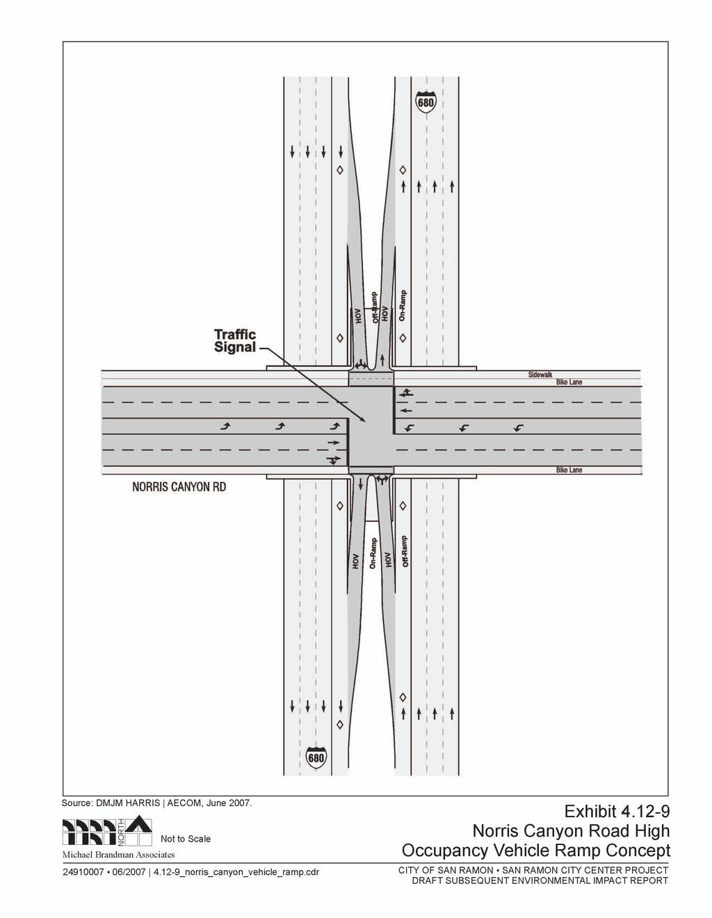
41 San Ramon City Center - City of San Ramon Draft Subsequent EIR In addition, the TVTC identified 11 transportation improvement projects as high priority for the region, including: I-580/I-680 interchange (completed). SR 84 - I-580 to I-680 Expressway. SR 84 - Isabel/Route 84 interchange at I-580. I-680 Auxiliary Lane Project Contra Costa (segments 1 and 3 completed). West Dublin BART Station (currently under construction). I-580 HOV Project. I-680 HOV Project-SR-84 to Sunol Grade. Foothill Road/San Ramon Road at I-580 interchange. Alcosta Boulevard/I-680 interchange (completed). Crow Canyon Road improvements - Alameda County portion. Vasco Road improvements - Alameda County portion. Express Bus Service - Alameda County (LAVTA). Interstate 680 Investment Options Study In 2003, DKS Associates, in association with CH2M Hill, prepared this study for the Contra Costa Authority. The study examined several long-term investment options for the I-680 corridor. The recommended option contained numerous improvements along I-680 in the study area. These improvements are referenced below. New Express Bus Service: Additional service between the study area and Martinez, East County, and Fremont/San Jose consistent with the Enhanced Scenario recommendations from the Express Bus Study; eight new buses in this service area; and expansion of the existing CCCTA maintenance facility to accommodate additional buses. The additional express bus service would not replace or compete with existing bus service. Initiation of a Project Study Report for the Norris Canyon Project: The Contra Costa Authority, in concert with San Ramon and Caltrans, will develop and finalize a PSR that will confirm the scope, schedule, and estimated costs of the Norris Canyon project. The Project will provide convenient and direct access for transit, car/vanpools to and from the San Ramon Transit Center and will improve safety by reducing the amount of weaving by HOVs entering or exiting the freeway. Exhibit illustrates the HOV ramp concept. The Project Study Report is anticipated to be completed by August San Ramon Transit Center Enhancements: Includes expanded parking to be achieved through lease agreements with adjacent properties. HOV Lane Extension South (Alcosta Boulevard to south of the I-580 Junction): Includes restriping the median and widening the outside shoulder to create the width necessary to extend Michael Brandman Associates H:\Client (PN-JN)\2491\ \DSEIR\ _Sec04-12.doc
42 San Ramon City Center - City of San Ramon Draft Subsequent EIR the HOV lanes through the interchange. This project may require design exemptions to accommodate an additional lane. Northbound HOV Lane Extension: North (Livorna Road to North Main Street): Through the SR-24 junction. A Project Study Report is currently underway. Sycamore Valley Road Direct HOV Ramps: Includes reconstruction of interchange, widening of median, and construction of new HOV-only on- and off-ramps in both the northbound and southbound directions. Measure J Contra Costa s Sales Tax Expenditure Plan, adopted by Contra Costa voters in 2004, will continue with the County s existing 0.5-cent transportation sales tax to The Expenditure Plan includes Capital Improvement Projects and Programs ranging from the Caldecott Tunnel Fourth Bore, Highway 4 expansion, intersection improvements on I-680 and SR-242, adding express bus service from Central Contra Costa to the San Ramon Valley, a San Ramon Valley School Bus Program, pedestrian, bicycle and trail facilities, and other improvements. The Interstate 680 Carpool Lane Gap Closures/Transit Corridor Improvement is a critical capital improvement project for the San Ramon Valley. The project will extend existing bus/carpool/ vanpool lanes on southbound I-680 from North Main Street to Livorna Road and northbound from North Main Street to north of SR-242, construct bus/carpool on-and-off ramps at Norris Canyon Road and/or Sycamore Valley Road, and include other transit corridor improvements. County Connection Fiscal Years Short-Range Transit Plan A short-range transit plan addresses transit improvements expected over the next five years. The plan justifies the County Connection s funding requests and outlines likely changes in services and operations in the future. The plan is based on current information that is subject to change as new data becomes available. The changes listed below are divided in two groups: Track I and Track II. Track I changes are expected to be implemented in the foreseeable future. Track II changes depend on the availability of funding and may or may not be implemented within a reasonable period. Track I Planned Service Changes Route 121 Alignment Changes New Service Using Out-of Service Bus Trips: This project will review current out-of service bus trips for the potential of operating this trip or portions of these trips as regular in-service trips. Each day, County Connection buses travel between the operations facility and the starting points of the routes. These trips could provide service between San Ramon and Dublin, and between downtown Concord and the north Concord industrial area Michael Brandman Associates H:\Client (PN-JN)\2491\ \DSEIR\ _Sec04-12.doc
43
Magnolia Place. Traffic Impact Analysis. Prepared for: City of San Mateo. Prepared by: Hexagon Transportation Consultants, Inc.
 Magnolia Place Traffic Impact Analysis Prepared for: City of San Mateo Prepared by: Hexagon Transportation Consultants, Inc. Updated January 4, 2010 Table of Contents 1. Introduction...1 2. Existing Conditions...6
3.9 - Transportation and Traffic
 Transportation and Traffic 3.9 - Transportation and Traffic This section describes the potential transportation and traffic effects of project implementation on the project site and its surrounding area.
Abrams Associates. Transportation Impact Analysis. City of Rocklin. Prepared for: David Mohlenbrok City of Rocklin 4081 Alvis Court Rocklin, CA 95677
 Transportation Impact Analysis Sierra College Boulevard Commercial Project City of Rocklin Prepared for: David Mohlenbrok City of Rocklin 081 Alvis Court Rocklin, CA 95677 Prepared by: 1875 Olympic Boulevard,
Mission Street Medical Office Development
 reet Medical Office Development Traffic Impact Analysis Prepared for: Palo Alto Medical Foundation February 23, 2012 Hexagon Office: 7888 Wren Avenue, Suite B121 Gilroy, CA 95020 Hexagon Job Number: 11RD11
5.3 TRAFFIC, CIRCULATION AND PARKING
 5.3 TRAFFIC, CIRCULATION AND PARKING This section is based upon the Downtown Lancaster Specific Plan Traffic Impact Analysis (April 2, 2008) and the Downtown Lancaster Specific Plan Parking Analysis (May
4. ENVIRONMENTAL IMPACT ANALYSIS 9. TRANSPORTATION AND TRAFFIC
 4. ENVIRONMENTAL IMPACT ANALYSIS 9. TRANSPORTATION AND TRAFFIC 4.9.1 INTRODUCTION The following section addresses the Proposed Project s impact on transportation and traffic based on the Traffic Study
Subject: Solberg Avenue / I-229 Grade Separation: Traffic Analysis
 MEMORANDUM Transportation Bill Troe, AICP Jason Carbee, AICP 12120 Shamrock Plaza Suite 300 Omaha, NE 68154 (402) 334-8181 (402) 334-1984 (Fax) To: Project File Date: Subject: Solberg Avenue / I-229 Grade
THIS PAGE LEFT BLANK INTENTIONALLY
 GA SR 25 Spur at Canal Road Transportation Impact Analysis PREPARED FOR GLYNN COUNTY, GEORGIA 1725 Reynolds Street, Suite 300 Brunswick, Georgia 31520 PREPARED BY 217 Arrowhead Boulevard Suite 26 Jonesboro,
Focused Traffic Analysis for the 200 Nellen Avenue Project
 March 13, 2017 Mr. Phil Boyle Town of Corte Madera 300 Tamalpais Drive Corte Madera, CA 94976-0159 Focused Traffic Analysis for the 200 Nellen Avenue Project Dear Mr. Boyle; W-Trans has completed a focused
4.13 TRANSPORTATION AND TRAFFIC
 4.13 This chapter describes the regulatory framework and existing conditions in the vicinity of the Project site related to transportation and traffic, and the potential impacts of the proposed Project
MOUNTAIN HOUSE SPECIFIC PLAN I 9.1 INTRODUCTION ASSUMPTIONS TRANSPORTATION FACILITIES TRANSPORTATION IMPROVEMENTS PHASING 9.
 CHAPTER NINE: TRANSPORTATION AND CIRCULATION 9.1 INTRODUCTION 9.1 9.2 ASSUMPTIONS 9.1 9.3 TRANSPORTATION FACILITIES 9.1 9.4 TRANSPORTATION IMPROVEMENTS PHASING 9.3 LIST OF FIGURES LIST OF TABLES Figure
Clackamas County Comprehensive Plan
 ROADWAYS The County s road system permits the movement of goods and people between communities and regions, using any of a variety of modes of travel. Roads provide access to virtually all property. They
3.0 PROJECT DESCRIPTION
 The following section of the Draft EIR contains a description of the proposed Elk Grove Boulevard/SR 99 Interchange Modification project, consistent with the requirements of CEQA Guidelines Section 15124.
TRAFFIC IMPACT ANALYSIS
 TRAFFIC IMPACT ANALYSIS FOR THE CHAMPAIGN UNIT#4 SCHOOL DISTRICT PROPOSED HIGH SCHOOL (SPALDING PARK SITE) IN THE CITY OF CHAMPAIGN Final Report Champaign Urbana Urbanized Area Transportation Study 6/24/2014
TABLE TRAFFIC ANALYSIS SCENARIOS
 4.11 TRANSPORTATION The potential traffic impacts of the proposed project are evaluated in the Buena Park Beach/Orangethorpe Mixed Use Project Traffic Analysis (Traffic Analysis) by Austin-Foust Associates
4.10 TRAFFIC AND CIRCULATION
 4.10 TRAFFIC AND CIRCULATION The following section is based on a traffic and circulation study prepared by Fehr & Peers, Inc. (November 2003; refer to Appendix F for technical calculations). The effects
D.13 Transportation and Traffic
 This section addresses transportation and traffic issues and impacts related to the Proposed Project. Section D.13.1 provides a description of the affected environment for the Proposed Project. Applicable
Los Altos Hills Town Council - June 18, 2015 Palo Alto City Council June 22, AGENDA ITEM #2.B Presentation
 Los Altos Hills Town Council - June 18, 2015 Palo Alto City Council June 22, 2015 AGENDA ITEM #2.B Presentation Previous Presentations Los Altos Hills Town Council in May 2014 and February 2015 Palo Alto
5858 N COLLEGE, LLC N College Avenue Traffic Impact Study
 5858 N COLLEGE, LLC nue Traffic Impact Study August 22, 2016 Contents Traffic Impact Study Page Preparer Qualifications... 1 Introduction... 2 Existing Roadway Conditions... 5 Existing Traffic Conditions...
4.11 TRANSPORTATION 4.11 TRANSPORTATION Environmental Setting Intersection, Roadway, and Freeway Evaluation Methodology
 4.11 TRANSPORTATION This section describes the road transportation system in the vicinity of the proposed Project and the potential impacts to this system from the proposed Project. The analysis in this
Circulation in Elk Grove includes: Motor vehicles, including cars and trucks
 Circulation, as it is used in this General Plan, refers to the many ways people and goods move from place to place in Elk Grove and the region. Circulation in Elk Grove includes: Motor vehicles, including
HENDERSON DEVELOPMENT 213, 217, 221, 221 ½, 223 HENDERSON AVENUE and 65 TEMPLETON STREET OTTAWA, ONTARIO TRANSPORTATION OVERVIEW.
 HENDERSON DEVELOPMENT 213, 217, 221, 221 ½, 223 HENDERSON AVENUE and 65 TEMPLETON STREET OTTAWA, ONTARIO TRANSPORTATION OVERVIEW Prepared for: 2294170 Ontario Inc. February 2, 2017 117-652 Report_1.doc
9 Leeming Drive Redevelopment Ottawa, ON Transportation Brief. Prepared By: Stantec Consulting Ltd.
 9 Leeming Drive Redevelopment Ottawa, ON Transportation Brief Prepared By: Stantec Consulting Ltd. TIA GUIDELINES CHECKLIST Report Context Municipal Address Comment: Section 1.1 Location relative to major
APPENDIX S REVISED PAGES OF THE SUPPLEMENTAL TRAFFIC IMPACT ANALYSIS
 APPENDIX S REVISED PAGES OF THE SUPPLEMENTAL TRAFFIC IMPACT ANALYSIS The capacity of the toll plaza was estimated based on data from numerous studies as well as traffic counts conducted at the toll plaza
TRAFFIC IMPACT STUDY CRITERIA
 Chapter 6 - TRAFFIC IMPACT STUDY CRITERIA 6.1 GENERAL PROVISIONS 6.1.1. Purpose: The purpose of this document is to outline a standard format for preparing a traffic impact study in the City of Steamboat
June 3, Attention: David Hogan City of San Mateo 330 W. 2oth Avenue San Mateo, CA 94403
 June 3, 2015 Attention: David Hogan City of San Mateo 330 W. 2oth Avenue San Mateo, CA 94403 Regarding: PA # 15-030, Bridgepointe Shopping Center 2202 Bridgepointe Parkway, APN 035-466-10 Dear David: Enclosed
 TRAFFIC IMPACT STUDY CANYON HILLS PROJECT LOS ANGELES, CALIFORNIA INTRODUCTION This traffic analysis has been conducted to identify and evaluate the potential traffic impacts of the proposed Canyon Hills
APPENDIX F SUPPLEMENTAL TRAFFIC DATA
 APPENDIX F SUPPLEMENTAL TRAFFIC DATA Environmental and Planning Consultants 440 Park Avenue South 7th Floor New York, NY 10016 tel: 212 696-0670 fax: 212 213-3191 www.akrf.com Draft Memorandum To: Michael
Sixth Line Development - Transit Facilities Plan
 Memorandum Date: November 13, 2012 To: From: c.c. Subject: Rob Freeman (Freeman Planning) Kevin Phillips Sixth Line Development - Transit Facilities Plan 33016631 This memo was prepared to review the transit
SANTA CLARA COUNTYWIDE BICYCLE PLAN August 2008
 SANTA CLARA COUNTYWIDE BICYCLE PLAN August 2008 To assist VTA and Member Agencies in the planning, development and programming of bicycle improvements in Santa Clara County. Vision Statement To establish,
Traffic Circulation Study for Neighborhood Southwest of Mockingbird Lane and Airline Road, Highland Park, Texas
 ARIZONA TEXAS NEW MEXICO OKLAHOMA February 13, 2015 Mr. Meran Dadgostar P.E., R.S. Town of Highland Park 4700 Drexel Dr. Highland Park, Texas 75205 Re: Traffic Circulation Study for Neighborhood Southwest
Transportation Impact Study for Abington Terrace
 Transportation Impact Study for Abington Terrace Abington Township, Montgomery County, PA Sandy A. Koza, P.E., PTOE PA PE License Number PE059911 Prepared by McMahon Associates, Inc. 425 Commerce Drive,
Bridge Street Corridor Study Report
 Bridge Street Corridor Study Report Prepared for: Prepared by: BRIDGE STREET CORRIDOR STUDY REPORT PREPARED FOR: CITY OF ARROYO GRANDE COMMUNITY DEVELOPMENT DEPARTMENT 300 EAST BRANCH STREET ARROYO GRANDE,
3.16 TRANSPORTATION, CIRCULATION, AND PARKING Regulatory Setting Environmental Setting ROADWAY SYSTEM
 3.16 TRANSPORTATION, CIRCULATION, AND PARKING This section assesses the potential for implementation of the Orchard Park Redevelopment component of the 2018 LRDP to result in impacts related to transportation,
B. TRANSPORTATION, CIRCULATION AND PARKING
 FEBRUARY 0 89 EL CAMINO REAL PROJECT EIR This section describes the existing traffic, circulation, parking, and transit conditions in the vicinity of the project site and provides an analysis of the project
City of Homewood Transportation Plan
 City of Homewood Transportation Plan Prepared for: City of Homewood, Alabama Prepared by: Skipper Consulting, Inc. May 2007 TABLE OF CONTENTS INTRODUCTION... 1 BACKGROUND INFORMATION... 1 EXISTING TRANSPORTATION
3.9 Recreational Trails and Natural Areas
 3.9 Recreational Trails and Natural Areas 3.9.1 Introduction Parks and other recreational facilities such as trails, bicycle routes, and open space are important community resources. This section discusses
TABLE OF CONTENTS. Executive Summary
 Executive Summary Background... ES-1 Pedestrian Network... ES-2 Bikeway Network... ES-2 Collision History... ES-2 Public Input... ES-4 Conclusions and Recommendations... ES-4 1. Introduction and Setting
TRAFFIC ASSESSMENT River Edge Colorado
 TRAFFIC ASSESSMENT River Edge Colorado Submitted by: Fehr & Peers 621 17th Street, Ste. 231 Denver, CO 8293 (33) 296-43 December, 21 App. M-2 Traffic Assessment River Edge Colorado December 21 TABLE OF
4.12 TRANSPORTATION Executive Summary. Setting
 4.12 TRANSPORTATION 4.12.1 Executive Summary This section is based on the Multimodal Transportation Impact Study (TIS; 2016) prepared by Omni-Means, Ltd. to evaluate projected transportation impact conditions
List of Attachments. Location Map... Site Plan... City of Lake Elsinore Circulation Element... City of Lake Elsinore Roadway Cross-Sections...
 List of Attachments Exhibits Location Map... Site Plan... City of Lake Elsinore Circulation Element... City of Lake Elsinore Roadway Cross-Sections... Existing Lane Geometry and Traffic Controls... Existing
University Hill Transportation Study Technical Memorandum Alternatives Modeling and Analysis May 2007
 Technical Memorandum May 2007 Syracuse Metropolitan Transportation Council Edwards and Kelcey with Wallace Roberts and Todd Alta Planning and Design CONTENTS SECTION ONE- INTRODUCTION...1 SECTION TWO-
Recommended Roadway Plan Section 2 - Land Development and Roadway Access
 Recommended Roadway Plan Section 2 - Land Development and Roadway Access SECTION 2 Land Development and Roadway Access 2.1 Land Use and Access Management The Federal Highway Administration (FHWA) defines
TRAFFIC IMPACT STUDY And A TRAFFIC SIGNAL WARRANT ANALYSIS FOR A SENIOR LIVING AND APARTMENT DEVELOPMENT
 TRAFFIC IMPACT STUDY And A TRAFFIC SIGNAL WARRANT ANALYSIS FOR A SENIOR LIVING AND APARTMENT DEVELOPMENT DEERFIELD TOWNSHIP, WARREN COUNTY, OHIO Nantucket Circle and Montgomery Road () Prepared for: ODLE
TRAFFIC OPERATIONS ANALYSIS REPORT. Pacheco Boulevard Alignment Study and Alternatives Analysis
 TRAFFIC OPERATIONS ANALYSIS REPORT Pacheco Boulevard Alignment Study and Alternatives Analysis PREPARED FOR: CITY OF MARTINEZ AND CONTRA COSTA COUNTY OCTOBER 2016 FINAL REPORT Prepared By: under contract
3.9 - Traffic and Transportation
 Sacramento LAFCo - Incorporation of Arden Arcade Traffic and Transportation 3.9 - Traffic and Transportation 3.9.1 - Summary This section describes the existing traffic and transportation conditions and
TRANSPORTATION TRAINING TOPICS. April 6, 2010
 TRANSPORTATION TRAINING TOPICS April 6, 2010 Roles of Transportation Providers Context and Policy Makers Division of Transportation and Traffic Other City Operations Other Transportation Operators CMA
ALLEY 24 TRAFFIC STUDY
 ALLEY 24 TRAFFIC STUDY in City of Frostburg, Maryland January 2013 3566 Teays Valley Road Hurricane, WV Office: (304) 397-5508 www.denniscorporation.com Alley 24 Traffic Study January 2013 Frostburg, Maryland
4.11 Transportation and Traffic
 4.11.1 Introduction This section evaluates whether implementation of the Russian River Estuary Management Project (Estuary Management Project) would result in potential adverse impacts related to transportation
Figure 1: East West Connector Alignment Alternatives Concept Drawing
 Page 2 of 9 Figure 1: East West Connector Alignment Alternatives Concept Drawing The Montebello Drive extension will run north south and connect Wilsonville Road to the Boones Ferry Road to Brown Road
Traffic Impact Analysis Chatham County Grocery Chatham County, NC
 Chatham County Grocery Chatham County, NC TABLE OF CONTENTS 1. INTRODUCTION... 1 1.1. Location and Study Area... 1 1.2. Proposed Land Use and Access... 2 1.3. Adjacent Land Uses... 2 1.4. Existing ways...
TRAFFIC ACTION PLAN. North Central Neighborhood CITY OF SAN MATEO
 TRAFFIC ACTION PLAN North Central Neighborhood CITY OF SAN MATEO Draft February 2017 Table of Contents Introduction... 1 The Traffic Forum Process... 4 Neighborhood Traffic Issues... 6 Neighborhood Recommendations
Planning Committee STAFF REPORT March 7, 2018 Page 2 of 4 The following MTSOs are being used across the five subregions: Intersection Level of Service
 Planning Committee STAFF REPORT Meeting Date: March 7, 2018 Subject Summary of Issues Recommendations Financial Implications Options Attachments Changes from Committee Review Draft 2017 Multimodal Transportation
Appendix C. NORTH METRO STATION AREA TRAFFIC IMPACT STATEMENT 88th Avenue Station
 Appendix C NORTH METRO STATION AREA TRAFFIC IMPACT STATEMENT 88th Avenue Station Prepared for: Regional Transportation Department and URS Corporation as part of the North Metro EIS David Evans and Associates,
Traffic Impact Study WestBranch Residential Development Davidson, NC March 2016
 Traffic Impact Study WestBranch Residential Development Davidson, NC March 216 TRAFFIC IMPACT STUDY FOR THE WestBranch Residential Development LOCATED IN DAVIDSON, NC Prepared For: Lennar Carolinas, LLC
Walmart (Store # ) 60 th Street North and Marion Road Sioux Falls, South Dakota
 60 th Street North and Marion Road Sioux Falls, South Dakota") Walmart (Store #4865-00) 60 th Street North and Marion Road Sioux Falls, South Dakota Prepared for: Wal-Mart Stores, Inc. Bentonville, Arkansas Prepared by: Kimley-Horn and Associates, Inc. ã2013 Kimley-Horn
Walmart (Store #4865-00) 60 th Street North and Marion Road Sioux Falls, South Dakota Prepared for: Wal-Mart Stores, Inc. Bentonville, Arkansas Prepared by: Kimley-Horn and Associates, Inc. ã2013 Kimley-Horn
EXECUTIVE SUMMARY... vii 1 STUDY OVERVIEW Study Scope Study Area Study Objectives
 Contents EXECUTIVE SUMMARY... vii 1 STUDY OVERVIEW... 1-1 1.1 Study Scope... 1-1 1.2 Study Area... 1-1 1.3 Study Objectives... 1-3 2 EXISTING CONDITIONS... 2-1 2.1 Existing Freeway Conditions... 2-4 2.1.1
CITY OF ALPHARETTA DOWNTOWN MASTER PLAN TRAFFIC EVALUATION
 CITY OF ALPHARETTA DOWNTOWN MASTER PLAN TRAFFIC EVALUATION June 2015 CITY OF ALPHARETTA DOWNTOWN MASTER PLAN TRAFFIC EVALUATION Introduction The Alpharetta Downtown Master Plan was developed in the fall
SANTA MONICA BOULEVARD CORRIDOR
 CIRCULATION ELEMENT WHITE PAPER NO. 3 SANTA MONICA BOULEVARD CORRIDOR INTRODUCTION From the 1930s to the beginning of Los Angeles freeway era, Santa Monica Boulevard, (previously Route 66, the Beverly
6.14 Traffic and Circulation
 6.14 Traffic and Circulation 6.14.1 Introduction The analysis in this section summarizes the findings and recommendations presented in the "Marywood Development Traffic Impact Study, City of Orange, California"
APPENDIX H TRAFFIC REPORT
 APPENDIX H TRAFFIC REPORT Keith Higgins Traffic En ginee r WEST END SAND CITY TRAFFIC IMPACT ANALYSIS DRAFT REPORT SAND CITY, CALIFORNIA Prepared for DBO Development No. 3 Monterey, CA Prepared by Keith
Route 7 Corridor Study
 Route 7 Corridor Study Executive Summary Study Area The following report analyzes a segment of the Virginia State Route 7 corridor. The corridor study area, spanning over 5 miles in length, is a multi
Chapter 4 Traffic Analysis
 Chapter 4 Traffic Analysis PURPOSE The traffic analysis component of the K-68 Corridor Management Plan incorporates information on the existing transportation network, such as traffic volumes and intersection
APPENDIX G: INTERSECTION NEEDS AT OKEECHOBEE BOULEVARD
 APPENDIX G: INTERSECTION NEEDS AT OKEECHOBEE BOULEVARD INTERSECTION NEEDS AT SR 7 and OKEECHOBEE BOULEVARD SR 7 Extension Project Development and Environment (PD&E) Study From Okeechobee Boulevard (SR
TRAFFIC IMPACT STUDY COMPREHENSIVE UPDATE TOWN OF THOMPSON S STATION, TENNESSEE PREPARED FOR: THE TOWN OF THOMPSON S STATION
 TRAFFIC IMPACT STUDY COMPREHENSIVE UPDATE TOWN OF THOMPSON S STATION, TENNESSEE PREPARED FOR: THE TOWN OF THOMPSON S STATION Transportation Consultants, LLC 1101 17 TH AVENUE SOUTH NASHVILLE, TN 37212
Access Management Regulations and Standards
 Access Management Regulations and Standards January 2014 Efficient highway operation Reasonable property access Concept of Access Management The way to manage access to land development while preserving
EAST AND SOUTH STREET CITY OF ANAHEIM, CALIFORNIA
 T R A F F I C I M P A C T A N A LY S I S EAST AND SOUTH STREET CITY OF ANAHEIM, CALIFORNIA April 217 T R A F F I C I M P A C T A N A LY S I S EAST AND SOUTH STREET CITY OF ANAHEIM, CALIFORNIA Submitted
Lyons Avenue/Dockweiler Road Extension Project Draft Environmental Impact Report. Appendix I Traffic Impact Study
 Lyons Avenue/Dockweiler Road Extension Project Draft Environmental Impact Report Appendix I Traffic Impact Study Street 0 80-1947 500.4501 RITA ld Court 0 91355-1096 400.7401 LA n Avenue 0 590-3745 300-9301
Santa Clara I-280 CORRIDOR STUDY
 Santa Clara I-280 CORRIDOR STUDY OCTOBER 2017 PREPARED BY: 1.1 Background The I-280 Corridor Study within Santa Clara County is a high-level highway planning study led by the Santa Clara VTA, in partnership
1609 E. FRANKLIN STREET HOTEL TRAFFIC IMPACT STUDY EXECUTIVE SUMMARY
 1609 E. FRANKLIN STREET HOTEL TRAFFIC IMPACT STUDY EXECUTIVE SUMMARY Prepared for: The Town of Chapel Hill Public Works Department Traffic Engineering Division Prepared by: HNTB North Carolina, PC 343
SETTINGS AND OPPORTUNITIES MOBILITY & ACCESS
 7 mobility & access how do people use el camino what is it like to drive on el camino/to park along el camino what is the pedestrian experience like what is the role of transit along the corridor what
Highway 217 Corridor Study. Phase I Overview Report
 Highway 217 Corridor Study Phase I Overview Report November 3, 24 BACKGROUND AND OVERVIEW Study purpose The Highway 217 Corridor Study is developing multi-modal transportation solutions for traffic problems
REVIEW OF LOCAL TRAFFIC FLOW / LONG RANGE PLANNING SOLUTIONS STUDY
 ITEM Town of Atherton TRANSPORTATION COMMITTEE STAFF REPORT TO: FROM: MEMBERS OF THE COMMITTEE ROBERT OVADIA, PUBLIC WORKS DIRECTOR DATE: FEBRUARY 12, 2019 SUBJECT: REVIEW OF LOCAL TRAFFIC FLOW / LONG
V. ENVIRONMENTAL IMPACT ANALYSIS K. TRANSPORTATION AND CIRCULATION
 V. ENVIRONMENTAL IMPACT ANALYSIS K. TRANSPORTATION AND CIRCULATION ENVIRONMENTAL SETTING The following section is based on the Draft Traffic Circulation Study for the Malibu La Paz Project (Traffic Study),
Chapter 6 Transportation Plan
 Chapter 6 Transportation Plan Transportation Plan Introduction Chapter 6 Transportation Plan Transportation Plan Introduction This chapter describes the components of Arvada s transportation system, comprised
Chapter 16: Traffic and Parking A. INTRODUCTION
 Chapter 6: Traffic and Parking A. ITRODUCTIO This chapter examines the potential traffic and parking impacts of the proposed Fresh Kills Park roads. The analysis of transit and pedestrians is presented
Bicycle and Pedestrian Advisory Committee (BPAC) November 21, 2013
 November 21, 2013") Bicycle and Pedestrian Advisory Committee (BPAC) November 21, 2013 OVERALL LAND USE CONCEPT Overall Broadway Valdez District: 95.5 acres (35.1 acres right-of ways + 60.4 acres developable land) Plan Subareas:
Bicycle and Pedestrian Advisory Committee (BPAC) November 21, 2013 OVERALL LAND USE CONCEPT Overall Broadway Valdez District: 95.5 acres (35.1 acres right-of ways + 60.4 acres developable land) Plan Subareas:
3.13 TRANSPORTATION AND TRAFFIC
 3.13 TRANSPORTATION AND TRAFFIC INTRODUCTION This section of the Draft EIR describes the transportation and traffic based on the Transportation Impact Analysis (TIA) prepared by Overland Traffic Consultants,
1.0 INTRODUCTION 1.1 PURPOSE OF THIS REPORT
 1.0 INTRODUCTION This chapter provides an overview of the purpose, authorization and focus of this Recirculated Draft Environmental Impact Report (EIR), an identification of the Lead Agency, an outline
Shockoe Bottom Preliminary Traffic and Parking Analysis
 Shockoe Bottom Preliminary Traffic and Parking Analysis Richmond, Virginia August 14, 2013 Prepared For City of Richmond Department of Public Works Prepared By 1001 Boulders Pkwy Suite 300, Richmond, VA
Traffic Impact Memorandum. May 22, 2018
 BISHOP PROFESSIONAL DEVELOPMENT BUILDING Proposed Land-use Change & Parking Modification 3601 SW 31st Street Topeka, Kansas 66614 CFS Project No. 185077 Traffic Impact Memorandum May 22, 2018 Prepared
WELCOME TO OPEN HOUSE # 1 June 14, 2017
 Langstaff Road Weston Road to Highway 7 Class Environmental Assessment Study WELCOME TO OPEN HOUSE # 1 June 14, 2017 Please sign in and join our mailing list Purpose of Open House #1 & Study Area York
Technical Memorandum TRAFFIC IMPACT STUDY. RIDLEY ROAD CONVENIENCE STORE Southampton County, VA. Prepared for: Mr. David Williams.
 Technical Memorandum TRFFIC IMPCT STUDY RIDLEY ROD CONVENIENCE STORE Southampton County, V Prepared for: Mr. David Williams By: Charles Smith, P.E., PTOE EPR Charlottesville, V July 2014 1 TBLE OF CONTENTS
Highway 111 Corridor Study
 Highway 111 Corridor Study June, 2009 LINCOLN CO. HWY 111 CORRIDOR STUDY Draft Study Tea, South Dakota Prepared for City of Tea Sioux Falls Metropolitan Planning Organization Prepared by HDR Engineering,
Access Management Regulations and Standards
 Access Management Regulations and Standards Efficient highway operation Reasonable property access Concept of Access Management The way to manage access to land development while simultaneously preserving
Solana Beach Comprehensive Active Transportation Strategy (CATS)
") Solana Beach Comprehensive Active Transportation Strategy (CATS) 3.0 Goals & Policies The Solana Beach CATS goals and objectives outlined below were largely drawn from the Solana Beach Circulation Element
Solana Beach Comprehensive Active Transportation Strategy (CATS) 3.0 Goals & Policies The Solana Beach CATS goals and objectives outlined below were largely drawn from the Solana Beach Circulation Element
Prepared For: Shieldbay Developments Inc. c/o Matson, McConnell Ltd. 2430A Bloor Street West Toronto, Ontario M6S 1P9.
 Prepared For: Shieldbay Developments Inc. c/o Matson, McConnell Ltd. 2430A Bloor Street West Toronto, Ontario M6S 1P9 Prepared By: URS Canada Inc. 4 th Floor, 30 Leek Crescent Richmond Hill, Ontario L4B
Hidden Oaks Elementary School
 Hidden Oaks Elementary School SCHOOL ROUTE PLAN For HIDDEN OAKS ELEMENTARY SCHOOL LOCATION 13 ORANGE COUNTY Prepared for: ORANGE COUNTY SCHOOL ASSESSMENT PROGRAM ORANGE COUNTY PUBLIC WORKS Traffic Engineering
Corpus Christi Metropolitan Transportation Plan Fiscal Year Introduction:
 Introduction: The Safe, Accountable, Flexible, Efficient Transportation Equity Act: A Legacy for Users (SAFETEA-LU) has continued the efforts started through the Intermodal Surface Transportation Efficiency
TRANSPORTATION NEEDS ASSESSMENT
 TRANSPORTATION NEEDS ASSESSMENT A travel demand analysis was carried out to determine the operational issues and the potential benefit that adding traffic capacity would have on the road network. All the
REPORT CONCURRENCE. City Manager. The General Manager concurs with the recommendation of this report.
 COUNCIL REPORT Report No. ENG 08-018 Executive Committee Date: May 0, 018 File No: 5400-1 To: From: Subject: Mayor and Council Purvez Irani, Senior Transportation Engineer Bluejay Street Road Improvements
Appendix B. Environmental Resource Technical Memorandum. Assessment on Travel Pattern and Access Impacts
 Appendix B Environmental Resource Technical Memorandum Assessment on Travel Pattern and Access Impacts TECHNICAL MEMORANDUM ENVIRONMENTAL RE-EVALUATION FOR UNION STATION TO OAK CLIFF DALLAS STREETCAR To:
Following are our comments and findings based on the site visit and review of the complete Traffic Impact Study:
 3600 Horizon Boulevard Suite 250 Trevose, Pennsylvania 19053-4900 Voice 215.355.3577 Fax 215.355.3147 www.ekcorp.com November 1, 2006 Pennsylvania Department of Transportation Bureau of Highway Safety
South Albion-Bolton Community Plan North Hill Supermarket Transportation Study Part B: Evaluation of Alternatives
 Community Plan North Hill Supermarket Transportation Study Part B: Evaluation of Alternatives Prepared for: The Town of Caledon August 9 Transportation Solutions Ltd. 43 Forest Road Cambridge, ON N1S 3B4
EXECUTIVE SUMMARY OF CALEDON TRANSPORTATION NEEDS STUDY
 EXECUTIVE SUMMARY OF CALEDON TRANSPORTATION NEEDS STUDY The Caledon Transportation Needs Study has been undertaken as a joint project by the Town of Caledon and the Region of Peel to determine the existing
MOBILITY WORKSHOP. Joint City Council and Transportation Commission May 5, 2014
 MOBILITY WORKSHOP Joint City Council and Transportation Commission May 5, 2014 Review of General Plan M-1 Develop world-class transit system M-3 Maintain/enhance pedestrian-oriented City M-4 Create comprehensive
OFFICE/RETAIL DEVELOPMENT 1625 BANK STREET OTTAWA, ONTARIO TRANSPORTATION BRIEF. Prepared for: Canada Inc.
 OFFICE/RETAIL DEVELOPMENT 1625 BANK STREET OTTAWA, ONTARIO TRANSPORTATION BRIEF Prepared for: 9402209 Canada Inc. December 15, 2015 115-625 Report_2.doc D. J. Halpenny & Associates Ltd. Consulting Transportation
TABLE OF CONTENTS TABLE OF CONTENTS... I APPENDICES... III LIST OF EXHIBITS... V LIST OF TABLES... VII LIST OF ABBREVIATED TERMS...
 TABLE OF CONTENTS TABLE OF CONTENTS... I APPENDICES... III LIST OF EXHIBITS... V LIST OF TABLES... VII LIST OF ABBREVIATED TERMS... IX 1 INTRODUCTION... 1 1.1 Project Overview... 1 1.2 Analysis Scenarios...
#!! "$% ##! &! # '#! % $ #!
 Executive Summary US Highway 16 (US 16) is the primary corridor connecting Rapid City to the Black Hills region. It serves a growing population of commercial and residential traffic, as well as seasonal
MoPac South: Impact on Cesar Chavez Street and the Downtown Network
 MoPac South: Impact on Cesar Chavez Street and the Downtown Network Prepared by: The University of Texas at Austin Center for Transportation Research Prepared for: Central Texas Regional Mobility Authority