Delaware Avenue Corridor Study
|
|
|
- Antonia Ross
- 5 years ago
- Views:
Transcription

1 Delaware Avenue Corridor Study City of Marysville, Ohio February 19, 2009 ms consultants, inc. engineers, architects, planners 2221 Schrock Road Columbus, Ohio
2 ms ms consultants, inc. engineers - architects - planners Table of Contents Introduction... 1 Study Area... 1 Data Collection... 1 Traffic Volumes... 3 Capacity Analysis... 3 Charles Lane... 8 Coleman s Crossing Boulevard... 9 US 33 Eastbound Ramps US 33 Westbound Ramps Watkins Road/Square Drive Five Points Alternatives Signal Timing/Phasing Turn Lane Additions Roundabout Fifth Street Realignment Dunham Street Extension Safety Improvements Access Management Pedestrian/Bicycle Connectivity Signal System Timing Recommendations List of Figures Figure 1 Study Area... 2 Figure AM DHV... 4 Figure PM DHV... 5 Figure AM DHV... 6 Figure PM DHV... 7 Figure 6 Five Points Crash Diagram Figure 7 Potential Five Points Roundabout Figure 8 Potential Fifth Street Realignment Figure 9 Potential Dunham Street Extensions Figure 10 Potential Access Management Plan Figure 11 Recommended Improvements... 24
3 List of Tables Table 1 Charles Lane Intersection LOS & Delays... 8 Table 2 Coleman s Crossing Boulevard Intersection LOS & Delays... 9 Table 3 US 33 Eastbound Ramps Intersection LOS & Delays Table 4 US 33 Westbound Ramps Intersection LOS & Delays Table 5 Watkins Road/Square Drive Intersection LOS & Delays Table 6 Effects of Five Points Options on 2030 LOS & Delays Appendix Appendix A Appendix B Appendix C Appendix D Traffic Counts HCS Reports SimTraffic Reports Signal Timing Plans
4 Delaware Avenue Corridor Study Marysville, Ohio Introduction The purpose of this study is to analyze and provide recommendations for the Delaware Avenue corridor in the eastern portion of Marysville, Ohio. Each of the signalized intersections in the corridor will be evaluated to determine what, if any, improvements are necessary for traffic to operate successfully over the next two decades. A particular focus of this study is the Five Points intersection, where Delaware Avenue, Columbus Avenue, Fifth Street, and Cherry Street meet at a common point. This study will develop and evaluate several alternatives for addressing congestion and safety issues at this unique intersection. Also included in this study is a signal warrant analysis of the Coleman s Crossing Boulevard/Fifth Street intersection. Study Area The study area for this document includes Delaware Avenue from the Five Points intersection to the Watkins Road intersection. Figure 1 shows a map of the study area. There are a total of six signals in the study area, including two at the US 33 freeway interchange. The other four signals are at the Five Points intersection (Cherry Street/Columbus Avenue), Charles Lane, Coleman s Crossing Boulevard, and at Watkins Road. An at-grade CSX railroad crossing also exists on Delaware Avenue in the study area. Delaware Avenue is a commercial corridor, featuring primarily retail land uses. Delaware Avenue is a 3-lane roadway west of the Coleman s Crossing Boulevard intersection, which includes a center two-way left turn lane. Numerous businesses have access points onto Delaware Avenue in this area. East of Coleman s Crossing Boulevard, Delaware Avenue has two through lanes in each direction plus turn lanes and a wide median. No private access points exist on Delaware Avenue between Coleman s Crossing Boulevard and Watkins Road. Delaware Avenue is signed as US 36 east of the US 33 freeway interchange and tapers down to a 2-lane rural roadway east of the Watkins Road intersection. Data Collection AM and PM peak hour turning movement counts were collected as part of this study. Based on 24-hour traffic count data provided by the City of Marysville, the AM peak hour was determined to be 7:00-8:00 AM and the PM peak hour was determined to be 4:30-5:30 PM. Weekday turning movement counts were taken at each signalized intersection during these hours. The counts were conducted during March 2008, at which time the Fifth Street at-grade railroad crossing was closed. After Fifth Street was reopened at the railroad crossing, additional turning movement counts were taken at the Five Points and the Coleman s Crossing intersections. Copies of all count data are provided in Appendix A. In addition to turning movement counts, the City of Marysville provided daily traffic count data on approach legs to the Coleman s Crossing/Fifth Avenue intersection. These ms consultants, inc. engineers, architects, planners February 19, 2009 Page 1
5
6 Delaware Avenue Corridor Study Marysville, Ohio daily counts were conducted in June 2008, after the CSX crossing had been reopened. The City also provided the most recent three years of crash data ( ) for the study area. Notable highlights of the crash data are discussed in the following sections on each individual intersection. Traffic Volumes Because the Fifth Street railroad crossing is anticipated to remain open in the future, the turning movement counts taken while Fifth Street was open were used for the capacity analyses in this document. The newer traffic counts showed approximately 100 peak hour vehicles (roughly 50 in each direction) diverted to East Fifth Street after the railroad crossing opened. These diverted vehicles were removed from the east-west through volumes at the Charles Lane intersection. (As drivers get more accustomed to this new connection, traffic volumes could increase on Fifth Street. Future monitoring of Fifth Street is recommended for a potential signal warrant at Coleman s Crossing Boulevard.) The turning movement counts were compiled and smoothed to obtain 2008 AM and PM volumes for the study area. The appropriate ODOT Seasonal Adjustment factor of was applied to the smoothed count data, resulting in average weekday peak hour volumes. An ODOT Design Hourly Volume (DHV) factor of 1.21 was applied to the data to obtain design hour traffic for To develop design year (2030) traffic, a linear growth rate of 1.5% per year was applied to the existing volumes. Using data from the Marysville Water Master Study, a 1.5% growth rate was developed in previous traffic studies as a growth rate for the city. Because this corridor features retail uses that draw traffic from all parts of the city (e.g., Wal-Mart and Best Buy), this projected citywide growth rate is reasonable to use for this study. The resulting 2008 and 2030 traffic volumes are provided on Figures 2-5. Capacity Analysis Capacity analyses were performed for each intersection using Highway Capacity Software (HCS+) and Synchro/SimTraffic software. The HCS program is primarily used to evaluate the performance of individual signals and does not take into account the interaction and queuing from adjacent signals. Synchro/SimTraffic is a traffic modeling program that does account for the effects of signal progression and interaction of closely spaced signals. HCS and Synchro/SimTraffic analyses were performed for the 2008 and 2030 AM and PM design hours with the existing intersection configurations. For a developed, urbanized area like the Delaware Avenue corridor, level-of-service (LOS) D is generally considered to be acceptable traffic operations. If an intersection was not predicted to operate at LOS D or better in the 2030 design year, recommended improvements were identified to achieve the desired level-of-service. Capacity analyses for these recommended configurations were performed using the 2030 design hour volumes. Copies of all HCS reports can be found in Appendix B, while copies of the SimTraffic reports are provided in Appendix C. ms consultants, inc. engineers, architects, planners February 19, 2009 Page 3
7
8
9
10
11 Delaware Avenue Corridor Study Marysville, Ohio Because of the variability of individual SimTraffic simulations, a total of 10 SimTraffic runs were performed and averaged for each condition. It should be noted that SimTraffic results are based on the amount of delay vehicles experience waiting at a given intersection. If queuing from a signal extends into and beyond an adjacent intersection, the delays for these vehicles are included in the adjacent intersection s LOS calculations. In the following tables, locations have been noted where this shifting of delays has occurred in the SimTraffic results. Charles Lane Table 1 Charles Lane Intersection LOS & Delays (in seconds) Existing Network EB: L, TR WB: L, TR NB: L, TR SB: L, TR Recommended Configuration EB: L, T, TR WB: L, TR NB: L, TR SB: L, TR AM HCS C 20.3 C 20.8 C 20.7 AM SimTraffic A 9.7 B 10.5 B 10.9 PM HCS C 26.2 C 32.3 C 25.5 PM SimTraffic C 20.0 C 20.3 C 22.5 The capacity analyses in Table 1 show that this intersection will operate at LOS C or better through However, SimTraffic modeling shows that eastbound queues extend beyond the CSX railroad tracks and occasionally reach the Five Points Intersection. Crash reports indicate numerous rear-end collisions on eastbound Delaware Avenue between Five Points and Charles Lane, most likely resulting from queues at the Charles Lane or Coleman s Crossing signal. Adding a second eastbound lane approaching this signal could reduce these queue lengths. While it would be ideal for Delaware Avenue to have five lanes east of the Five Points intersection, a smaller widening project would also achieve safety and operational benefits. Adding a second eastbound lane approximately 300 feet east of the CSX railroad tracks would substantially reduce eastbound queuing at the Charles Lane signal. This could be done without the cost of widening Delaware Avenue at or west of the railroad crossing. ms consultants, inc. engineers, architects, planners February 19, 2009 Page 8
12 Delaware Avenue Corridor Study Marysville, Ohio Coleman s Crossing Boulevard Table 2 Coleman s Crossing Boulevard Intersection LOS & Delays (in seconds) Existing Network EB: L, T, T, R WB: L, L, T, R NB: L, TR, R SB: L, TR Recommended Configuration EB: L, T, T, R WB: L, L, T, R** NB: L, TR, R SB: L, TR AM HCS C 20.1 C 23.1 C 20.4 AM SimTraffic B 15.1 B 20.1 B 18.1 PM HCS C 30.8 D 44.1 C 33.1 PM SimTraffic C 32.8 E* 75.4 D 42.7 *Westbound left turn queues extend into upstream intersections. SimTraffic includes these delays in the calculations for these other intersections. **assumes that southbound Coleman s Crossing is widened to extend the existing two receiving lanes so that westbound dual left turn lanes are loaded equally. While the HCS analyses in Table 2 show that the overall intersection will operate at LOS D or better through 2030, several movements are expected to operate at LOS E or LOS F. In addition, SimTraffic modeling predicts the intersection operating at LOS E in 2030, with westbound left turn queues extending into the US 33 interchange intersections, contributing to very poor operations at those locations. Field observations have noted westbound dual left turn lane queues extending back to the US 33 freeway ramps. This is primarily due to the uneven loading of the left turn lanes. The rightmost left turn lane has very few vehicles because the right lane of Coleman s Crossing is tapered out less than 200 feet from the intersection. The second southbound lane of Coleman s Crossing Boulevard will need to be extended in order for the intersection to operate acceptably. Traffic counts at the Coleman s Crossing/Fifth Street intersection indicate that a low percentage (5%) of southbound vehicles turn onto Fifth Street or Charles Lane. Therefore, in order for the westbound dual left turn lanes to load evenly, the second southbound lane would need to extend to the Wal-Mart shopping center driveway. While not an ideal scenario because it would force left turns to be made from through lanes, it may be feasible to restripe the existing two-way left turn lane in this area to an additional southbound travel lane. This could be done as a short-term solution until a roadway widening project can be undertaken. ms consultants, inc. engineers, architects, planners February 19, 2009 Page 9
13 Delaware Avenue Corridor Study Marysville, Ohio The northbound and southbound left turn lanes are offset from each other, making it difficult for drivers to see oncoming through vehicles. Analysis of crash data did not show a crash pattern involving northbound and southbound left turns. However, traffic at this intersection continues to grow, particularly on the newer southbound approach. This intersection should continue to be monitored to determine when or if the offset left turn condition will need to be modified. The best solution, if needed, would be to eliminate the median on the southbound approach, which would allow for the southbound left turn lane to be shifted directly across from the northbound left turn lane. In this scenario, the current southbound left turn lane would be restriped as a through lane, and the shared through/right turn lane would be restriped as an exclusive right turn lane. This would also allow for a future dual southbound left turn lane if left turn traffic volumes increased more than anticipated. Split-phase operation of the north-south approaches would improve safety and could preserve the existing median, but it would add considerable delays to the intersection and is not recommended. An additional item for consideration at this intersection would be improved signage or pavement markings on the westbound approach. This is of particular concern because the leftmost through lane is forced off as a left turn lane. No advance signage or pavement markings indicate this condition until drivers get close to the intersection. It is recommended that advance signs, such as Thru Traffic Keep Right or overhead lane control signs, be installed just west of the US 33 westbound ramp intersection. Pavement markings could also be installed on the leftmost through lane to gain the attention of drivers. US 33 Eastbound Ramps The US 33 eastbound ramp has only one approach lane. By 2030, HCS analysis indicates that an additional lane will be needed to provide acceptable levels-of-service. One right turn lane and one left turn lane should be provided on the eastbound exit ramp approach to this intersection. No lane additions are expected to be necessary on the Delaware Avenue approaches to this intersection. However, it is recommended that a protectedpermissive westbound left turn phase should be added. While 2008 intersection levelsof-service are good, HCS shows that the westbound left turn currently operates at LOS E. Addition of a left turn phase will allow the westbound left turn movement to operate at LOS D or better through The HCS and SimTraffic results are shown in Table 3. ms consultants, inc. engineers, architects, planners February 19, 2009 Page 10
14 Delaware Avenue Corridor Study Marysville, Ohio Existing Network EB: T, T, R WB: L, T, T SB: LR Recommended Configuration EB: T, T, R WB: L, T, T SB: L, R Table 3 US 33 Eastbound Ramps Intersection LOS & Delays (in seconds) AM HCS B 19.2 C 27.0 B 19.5 AM SimTraffic C 20.7 B 26.1 B 17.1 PM HCS C 26.6 E 71.1 C 27.8 PM SimTraffic C 33.2 F 365.2* C 29.7** *Some of this delay can be attributed to queuing from the Coleman s Crossing intersection. **Some of the delay reduction can be attributed to improvements assumed at Coleman s Crossing intersection (extending southbound receiving lanes). US 33 Westbound Ramps The US 33 westbound ramp currently contains only one approach lane at this intersection. The capacity analyses show that the intersection will degrade to LOS E operations by In order to obtain acceptable levels-of-service, two additional lanes will need to be constructed by Two left turn lanes and one right turn lane are anticipated to be necessary on the exit ramp. No changes are recommended for the Delaware Avenue approaches to this intersection. The results of the capacity analyses are shown in Table 4. Existing Network EB: L, T, T WB: T, TR NB: LR Recommended Configuration EB: L, T, T WB: T, TR NB: L, L, R Table 4 US 33 Westbound Ramps Intersection LOS & Delays (in seconds) AM HCS B 19.9 C 25.6 B 19.5 AM SimTraffic B 15.3 C 20.5 B 14.5 PM HCS C 28.7 E 76.7 C 28.3 PM SimTraffic C 31.4 F 280.8* D 39.3** *Some of this delay can be attributed to queuing from the Coleman s Crossing intersection. **Some of the delay reduction can be attributed to improvements assumed at Coleman s Crossing intersection (extending southbound receiving lanes). ms consultants, inc. engineers, architects, planners February 19, 2009 Page 11
15 Delaware Avenue Corridor Study Marysville, Ohio Watkins Road/Square Drive Table 5 Watkins Road/Square Drive Intersection LOS & Delays (in seconds) Existing Network & Recommended Configuration EB: L, T, TR WB: L, T, TR NB: L, TR SB: L, TR AM HCS C 22.9 C 26.6 AM SimTraffic C 19.2 C 21.1 PM HCS C 25.1 D 44.0 PM SimTraffic C 20.3 C 26.0 The capacity analyses in Table 5 show that this intersection is expected to operate at LOS D or better through No improvements are expected to be necessary at this intersection. As noted in the Traffic Signal Study, the minor street left turn phases should optimally have second-car or third-car detection. This will help to reduce unnecessary signal phases during times of day with low traffic volumes. Currently, the Watkins Road or Square Drive left turn phases will activate when only one left turning vehicle is present on the approach. Five Points Intersection The Five Points intersection (Delaware Avenue & Cherry Street & Fifth Street & Columbus Avenue) is one of the most congested locations in the City of Marysville. As with most intersections containing greater than four approaches, the signal operations are not efficient because of the number of approaches that must be served. Even though the Five Points intersection does not have any exclusive turn phases, the signal still needs three phases to serve all vehicles. The eastbound and southwest-bound approaches (heaviest movements) are served in a common phase, then the Cherry Street and Columbus Street approaches are served in a common phase, and then the westbound Fifth Street approach has a phase. The eastbound Fifth Street approach currently contains a shared lane for left turns onto Cherry Street and Delaware Avenue plus a shared lane for through Fifth Street traffic and right turn traffic onto Columbus Avenue. The southwest-bound Delaware Avenue approach has a lane for left turns onto either Fifth Street or Columbus Avenue, plus a shared through/right-turn lane. Southbound Cherry Street has a lane for left turns onto Delaware Avenue or Fifth Street, plus a shared through/right turn lane. Columbus Avenue has only one northbound approach lane. Fifth Street has only one westbound approach lane. ms consultants, inc. engineers, architects, planners February 19, 2009 Page 12
16 Delaware Avenue Corridor Study Marysville, Ohio The current intersection design can also be confusing to motorists, with several streets intersecting at one point. The City of Marysville provided crash data for the Five Points intersection area, which is summarized on Figure 6. The most prevalent crash patterns are rear-end collisions on Delaware Avenue and Fifth Street (more frequent in the eastbound direction), as well as left turn crashes into and out of the United Dairy Farmers driveway on Cherry Street. Five options have been developed for the Five Points intersection to solve the capacity problems that exist today. Synchro/SimTraffic was used to analyze the effectiveness of these options. A total of 10 SimTraffic runs were performed for each option and averaged, with the results shown in Table 6. For simplicity, only the 2030 PM design hour (the most critical peak hour) was analyzed in Table 6. The AM design hour has much lower traffic volumes and is predicted to operate acceptably without any improvements in this corridor. Because some of the options effect the operations of adjacent intersections, these effects are also shown in Table 6. Each of the options shown in Table 6 is described in the paragraphs below. Table 6 Effects of Five Points Options on 2030 PM LOS & Delays Using SimTraffic (assuming improvements at other intersections in the Delaware Avenue corridor) Five Points Charles Lane & Delaware Avenue Coleman s Crossing & Delaware Avenue Total Network Delay (hrs.) *SIDRA results Existing F C 20.3 E 75.4 Phasing & Timing F C 20.9 E 79.6 Turn Lanes F 90.0 C 25.1 D 53.0 Roundabout B* 13.0 C 25.1 D 53.0 No Fifth leg E 57.4 C 30.4 D 54.4 Dunham Street (Phase 1) C 28.3 C 24.6 D N/A Signal Timing/Phasing Signal timing and phasing improvements were investigated to see if Five Points operations could be improved without roadway construction or other more costly options. Eastbound and southwest-bound left turns are currently permissive operations. Thus, adding left turn phases for these movements would create more delays and would not be beneficial. Another possible phasing adjustment would be to split-phase the northbound and southbound movements. This may improve safety, although no crashes have been reported in the most recent three years involving northbound or southbound left turns. Without the benefit of crash reduction, split-phasing would only add delays to the ms consultants, inc. engineers, architects, planners February 19, 2009 Page 13
17
18 Delaware Avenue Corridor Study Marysville, Ohio intersection. The results in Table 6, which include split-phasing and left turn phases, show these additional phases would be detrimental to intersection operations. Therefore, this option is not recommended for this intersection. Turn Lane Additions Given the current configuration of the intersection and the turning movement volumes, the turn lane additions that would provide the greatest benefit would be a southwestbound right turn lane and a northbound left turn lane. Synchro analyses indicate that these two turn lanes would greatly reduce vehicle delays. Both turn lanes may also improve intersection safety. The westbound right turn lane might help reduce rear-end collisions, while the northbound left turn lane would help to prevent southbound left turn crashes into northbound through vehicles. However, the SimTraffic analysis showed the intersection would remain at LOS F in Therefore, turn lane additions alone will not solve the capacity problems at this intersection. Roundabout This alternative would replace the existing intersection design with a roundabout. Because HCS and Synchro/SimTraffic are not optimal tools for analysis of roundabouts, this alternative was analyzed using SIDRA software. The SIDRA analysis showed that a one-lane roundabout would not provide an acceptable level-of-service. The northbound, southbound, and southwest-bound approaches were predicted to operate at LOS E or worse during the 2030 PM peak. The only way to obtain LOS D or better through the design year would be to provide two circulating lanes around the majority of the roundabout plus a southwest-bound right turn lane, as shown in Figure 7. This would allow for more gaps for approaching vehicles to accept, thus improving the level-ofservice. As seen on Figure 7, the roundabout alternative would require right-of-way from adjacent properties, with the greatest impact being on the parcel located between Columbus Avenue and the east leg of Fifth Street. It should be noted that the geometrics shown in Figure 7 represent the minimum possible impacts of the roundabout. If constructed, the approaches would likely be designed with curves to slow approaching traffic, thus requiring more right-of-way than implied by Figure 7. While this option does provide a good level-of-service, other options can provide acceptable traffic operations for less cost and right-of-way. Because the concept shown in Figure 7 has two lanes through much of the roundabout, it might seem logical that a full two-lane roundabout should be considered. While a full two-lane roundabout would help to reduce southwest-bound queuing on Delaware Avenue, such a design would be impractical without improvements on the west leg of Fifth Street. As only one westbound lane enters and leaves the intersection currently, a second westbound departure lane would be necessary in order for the roundabout alternative to improve traffic flow in the westbound direction. This would also require widening of Delaware Avenue from the Five Points to the US 33 eastbound ramp ms consultants, inc. engineers, architects, planners February 19, 2009 Page 15

19 Delaware Avenue Corridor Study Figure 7 Potential Five Points Roundabout
20 Delaware Avenue Corridor Study Marysville, Ohio intersection, in addition to widening or restriping Fifth Street west of the Five Points. If such widening projects were ever planned, a full two-lane roundabout would be a feasible and perhaps the best option for this intersection. However, until such projects are planned, a full two-lane roundabout is not practical at this location. Fifth Street Realignment Intersections with more than four approach legs are usually inefficient to operate because of the number of phases required to serve all the entering roadways. In this case, the Fifth Street approach has the lowest traffic volume, but receives it own exclusive signal phase. Removing the Fifth Street approach would allow the signal to be converted to two-phase operation. Fifth Street could be realigned west of the railroad tracks and connect to Columbus Avenue across from Dunham Street, as illustrated on Figure 8. While this would reduce the number of signal phases at the Five Points intersection, the total traffic volume would be nearly identical, as the majority of the westbound traffic on the realigned Fifth Street would be expected to turn right onto Columbus Avenue toward the Five Points. The SimTraffic analysis showed the Fifth Street Realignment would dramatically reduce delays, but Five Points would still operate at LOS E. Dunham Street Extension If Fifth Street were realigned to intersect Columbus Avenue across from Dunham Street, a western extension of Dunham Street could provide relief for the Five Points intersection. Traffic traveling between the residential south side of town and the Coleman s Crossing retail area could bypass the Five Points intersection by using this potential new roadway. In order to divert a substantial amount of traffic, Dunham Street would need to be extended to at least Chestnut Street. For optimal traffic operation at the Five Points, Dunham Street would be extended back to the Plum Street/Ninth Street intersection. An abandoned railroad alignment exists in this corridor that would be used as the roadway extension. The City of Marysville owns the right-of-way on this unoccupied corridor east of Vine Street. The corridor is privately owned west of Vine Street, but is largely unused, except for on the west side of Chestnut Street where it is used as part of an industrial site. Figure 9 shows the potential corridor for Dunham Street extensions. In the Synchro/SimTraffic analysis on Table 6, it was assumed that 100 vehicles in each direction would divert from the Delaware Avenue corridor onto the new Dunham Street extension if constructed. This would not only reduce traffic volumes from the Five Points intersection, but would reduce eastbound right turns and northbound left turns at the Delaware Avenue/Coleman s Crossing intersection. The assumption of 100 diverted vehicles is based on Dunham Street being extended only to Chestnut Street (labeled as Phase 1 on Figure 9). If Dunham Street were extended west to the Ninth Street/Plum Street intersection (labeled as Phase 2 on Figure 9), it is likely that even more traffic would divert from the Five Points intersection. With the Fifth Street Realignment and the ms consultants, inc. engineers, architects, planners February 19, 2009 Page 17
21 Delaware Avenue Corridor Study Legend New Curb/Edge of Pavement Pavement to be removed Figure 8 Proposed Fifth Street Realignment
22 Delaware Avenue Corridor Study Fifth Street Columbus Avenue Sixth Street Dunham Street Legend Dunham St. Extension Phase 1 Dunham St. Extension Phase 2 Proposed Fifth St. Realignment Pavement to be removed Figure 9 Potential Dunham Street Extensions Vine Street Chestnut Street Ninth Street Oak Street Seventh Street Eighth Street Plum Street Main Street
23 Delaware Avenue Corridor Study Marysville, Ohio Phase 1 Dunham Street extension, Synchro/SimTraffic predicts Five Points would operate at LOS C through Given that Phase 1 alone would provide acceptable operations at Five Points, Phase 2 would not be worth the expense and disruption to property owners and businesses in the corridor. The Phase 2 extension should only be considered if the land needed for Phase 2 was vacated in the future. It is therefore recommended that Fifth Street Realignment be constructed and Dunham Street be extended west to Chestnut Street only (Phase 1). Safety Improvements In the three-year analysis period ( ) of crash data, seven crashes involving vehicles turning left into or out of the United Dairy Farmers (UDF) driveway were reported. Most of the crashes occurred while traffic was queued in the southbound left turn lane at the Five Points signal and drivers attempted to turn into a gap in the queued traffic, only to be hit by moving traffic in another lane. Complicating this situation is the location of the UDF driveway, located on Cherry Street less than 100 feet north of the Five Points intersection. Due to the high number of crashes at this location, it is recommended that the UDF driveway be converted to right-in/right-out operation. (No crashes involving right turning vehicles were reported at this driveway.) Any vehicles that currently turn left into UDF can access the gas station via the Fifth Street driveway. Vehicles that currently turn left out of the UDF can turn right onto Fifth Street and circle the block via Vine Street and Fourth Street in order to access Cherry Street. Ideally, this driveway would also be located further away from the busy Five Points intersection. If the land use were to ever change on this site, it is recommended that the Cherry Street access point be relocated to the north edge of the parcel. Another safety consideration would be the possibility of prohibiting eastbound left turns from Fifth Street onto Cherry Street. The eastbound approach to this intersection features a shared through/left turn lane, meaning that the left turns can block the much heavier through movement. This eastbound left turn movement has fewer than 20 peak hour vehicles, thus a turn prohibition would not disrupt many drivers. Furthermore, there are several alternate routes that eastbound-to-northbound could divert to if this movement were prohibited. Because few blockages are occurring today, this would not have a noticeable effect on the intersection level-of-service. The left turn prohibition would be primarily to prevent rear-end crashes and occasional delays. Field observations have noted several near-collisions involving southbound vehicles not yielding to northbound through vehicles. There are two factors that contribute to southbound drivers having difficulty seeing northbound through vehicles. The curve just south of the intersection probably makes it challenging for southbound drivers to see approaching northbound traffic and to tell whether a vehicle has a turn signal on. Secondly, because the northbound approach only has one lane, southbound drivers may wrongly assume an approaching vehicle is about to turn left. A northbound through vehicle might suddenly go around a stopped left turning vehicle, surprising a southbound ms consultants, inc. engineers, architects, planners February 19, 2009 Page 20
24 Delaware Avenue Corridor Study Marysville, Ohio driver who assumed it was safe to make a left turn. While elimination of the Columbus Avenue curve would likely have significant property impacts to several parcels, providing a northbound left turn lane may only impact one parcel. Additionally, the turn lane would benefit the Five Points intersection capacity. Because no crashes were documented in the last three years, construction of a northbound left turn lane is not a high priority. However, if actual crashes start to occur (instead of the observed nearcollisions), a northbound left turn lane is recommended. Access Management The Delaware Avenue corridor was examined to identify access management solutions to implement in the study area. No driveways currently exist on Delaware Avenue in the study area east of Charles Lane. West of Charles Lane, numerous closely-spaced driveways are located on Delaware Avenue. Several properties have multiple access points that should be combined for optimal traffic operations. It is unreasonable to consolidate these driveways at this time. However, when properties redevelop in the corridor, sites with multiple access points on Delaware Avenue should be reduced to one driveway. There are two locations where driveways can be realigned with driveways or streets across Delaware Avenue. Another concern in the corridor is the presence of driveways near the CSX railroad crossing. The driveways immediately west of the railroad tracks can be eliminated or consolidated. The driveway east of the railroad tracks that serves the Ray Lewis & Son industrial property should not be eliminated unless the land use of the property changes. Even though Ray Lewis & Son has access to Cherry Street, it is not desirable to have truck traffic on Cherry Street and force trucks to make the hard turns at the Five Points intersection. Buerger Street also intersects Delaware Avenue in close proximity to the railroad tracks. Buerger Street could be closed north of Delaware Avenue to alleviate this situation, diverting traffic to Connolly Street. This may not be desirable because Connolly Street has a narrower street width and right-of-way than Buerger Street. One possible access management solution for this corridor would be to remove the signal at the Charles Lane intersection, which is in close proximity to the Coleman s Crossing signal. Charles Lane could be converted to right-in/right-out operation and backage roads could funnel left turns to the Coleman s Crossing signal. However, the Coleman s Crossing signal is already predicted to operate at LOS D, with delays nearly at LOS E levels (55 seconds per vehicle is the upper limit for LOS D). Adding inbound and outbound left turn volume to this intersection would likely cause unacceptable operations. Therefore, converting Charles Lane to right-in/right-out operation is not recommended. On the south side of Delaware Avenue, a connection between Charles Lane and Fifth Street would be beneficial, especially if the Fifth Street Realignment is constructed. Figure 10 shows an access management plan for the Delaware Avenue corridor. The items discussed in the previous two paragraphs have been incorporated into the plan. As ms consultants, inc. engineers, architects, planners February 19, 2009 Page 21
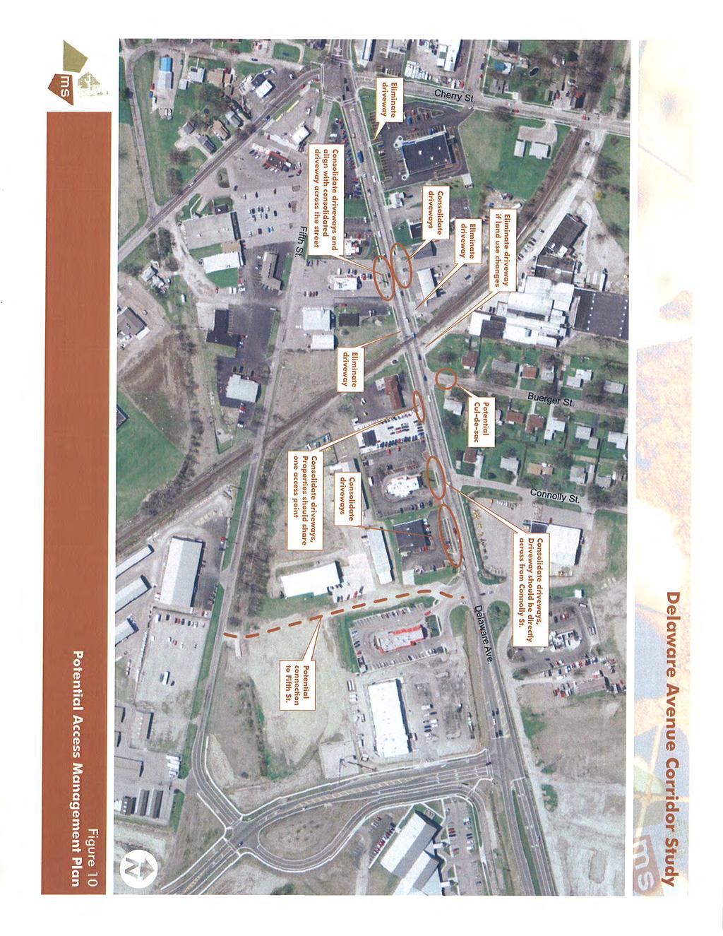
25
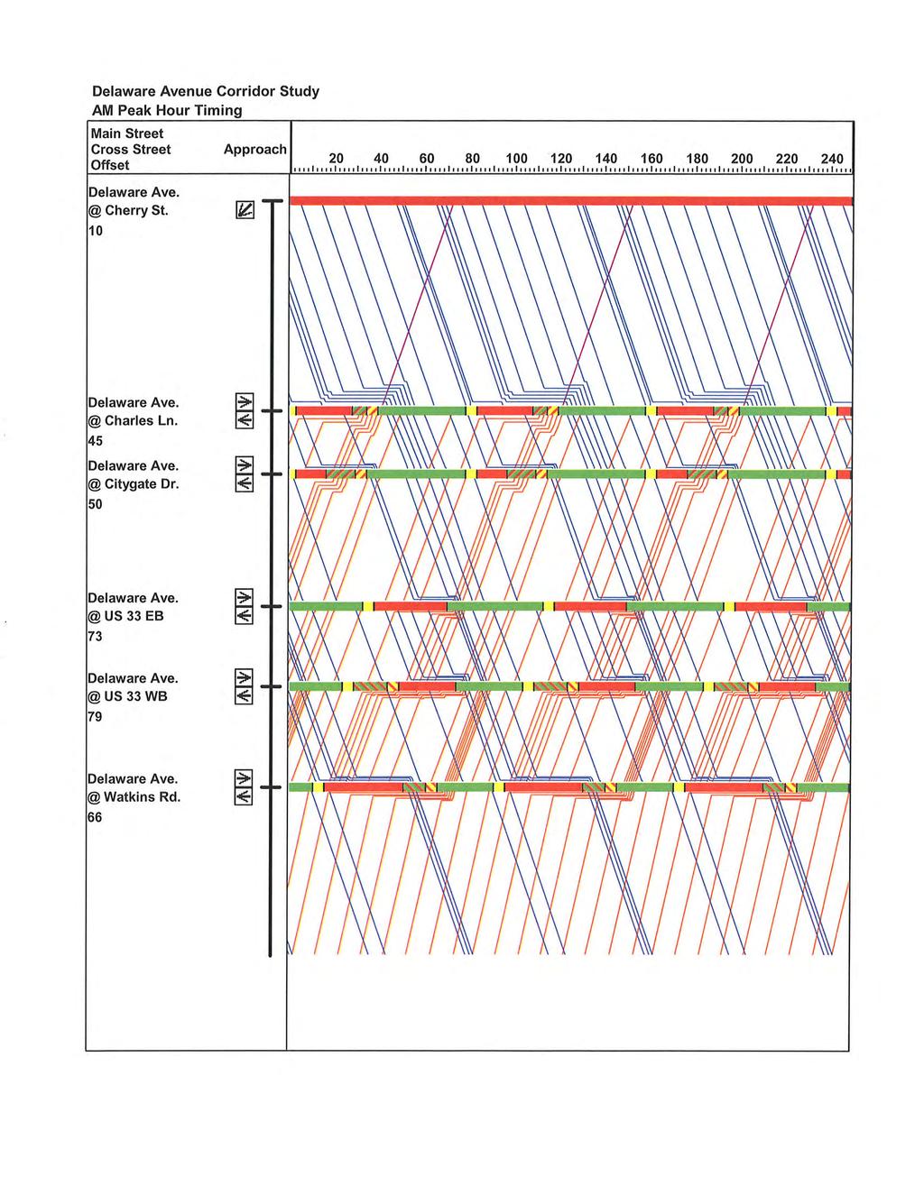
26 Delaware Avenue Corridor Study Marysville, Ohio previously noted, many of the recommendations are not reasonable to implement until properties redevelop in the corridor. Pedestrian/Bicycle Connectivity Sidewalks are presented throughout much of the Delaware Avenue corridor. On the south side of the street, sidewalks exist from Five Points to Charles Lane and from the US 33 eastbound ramps to Watkins Road. In between Charles Lane and the US 33 eastbound ramps, pedestrians can utilize sidewalks on the portions of Charles Lane that parallel Delaware Avenue. It is beneficial to have sidewalk located adjacent to the YMCA, which likely attracts pedestrian trips. However, any pedestrians traveling between Charles Lane and Coleman s Crossing have to walk through the Starbucks/Quizno s plaza parking lot. The section of Delaware Avenue between Charles Lane and Coleman s Crossing should have sidewalk installed adjacent to the south side of the street. On the north side of the street, sidewalks exist from Five Points to Charles Lane and a short sidewalk segment exists just west of Coleman s Crossing Boulevard. Ideally, sidewalks should be present on both sides of Delaware Avenue. However, there is probably limited demand for pedestrian traffic on the north side of the street through the interchange and the westbound US 33 ramp interchange features a free-flow slip ramp that pedestrians would have to cross. If funding permits, sidewalks should be installed on the entirety length of north side of the street, but it is not necessarily a high priority. From field observations, bicycle traffic does not currently appear to be a significant mode of travel in the Delaware Avenue corridor. The existing street does not have space for bike lanes to be provided. The existing right-of-way does not have room for a bicycle path in addition to the existing sidewalks. Many of the businesses in the corridor, particularly on the south side of the street, have parking lots that extend nearly to the sidewalk. The City of Marysville is currently developing a bicycle plan. If this corridor is identified as a location for future bicycle facilities (bike paths, bike lanes, etc.), then Delaware Avenue can be reevaluated to determine the best method of providing the recommendations. Signal System Timing Using the 2008 volumes, optimized signal timings were developed for the AM and PM peak hours. Currently, the signals in the corridor run on 100-second cycles. Based on optimization from Synchro, the best cycle length for the AM peak hour is 80 seconds. The cycle length for the PM peak hour is recommended to remain at 100 seconds. Synchro was then used to develop optimal intersection timing, phasing, and offsets. This optimization showed that the eastbound left turn phases at Coleman s Crossing and at the US 33 westbound ramp intersections should be lagging phases. The remaining left turn phases in the network should remain as leading left turn phases. Appendix D contains ms consultants, inc. engineers, architects, planners February 19, 2009 Page 23
27 Delaware Avenue Corridor Study Marysville, Ohio the recommended phase splits and offsets for each signal in the study area. Time-space diagrams are also provided in Appendix D. It should be noted that in some instances, the minor street through phases may not be long enough for pedestrians to cross Delaware Avenue. If the minor street pedestrian is called, the signal will have to briefly step out of coordination in order to allow for the proper pedestrian crossing time. Given the limited amount of pedestrian crossing activity in corridor, the signals would not be running uncoordinated often. Recommendations The following improvements are recommended for the Delaware Avenue corridor. Most of these recommendations can be found on Figure 11. Relocate northbound and southbound left turn detectors on Watkins Road to provide second-car or third-car detection for left turn phases Construct two additional approach lanes on US 33 westbound exit ramp Construct one additional approach lane on US 33 eastbound exit ramp Improve signage/pavement markings on westbound approach to Coleman s Crossing Boulevard intersection to warn of left lane being forced off Provide two southbound lanes on Coleman s Crossing Boulevard to Wal-Mart to allow for improved lane balance on westbound left turn lanes Monitor southbound Coleman s Crossing Boulevard approach traffic volumes and crashes o If a pattern of northbound or southbound left turn crashes develops, the southbound left turn lane should be realigned directly across from the northbound left turn lane (eliminating the median) o If traffic volumes increase on the southbound approach, the existing median should be used to provide an additional approach lane Widen Delaware Avenue to provide two eastbound lanes from approximately 300 feet east of the CSX railroad tracks to the existing two-lane eastbound section Implement Fifth Street Realignment, as shown in Figure 8 Implement Phase 1 of Dunham Street Extension, as shown in Figure 9 Convert United Dairy Farmers driveway on Cherry Street to right-in/right-out operation, and potentially move driveway north if future opportunity exists ms consultants, inc. engineers, architects, planners February 19, 2009 Page 24
28
29 Delaware Avenue Corridor Study Marysville, Ohio Add northbound left turn lane on Columbus Avenue Prohibit eastbound left turns at Five Points intersection Implementation of access management, such as the plan provided on Figure 10, when properties redevelop in the Delaware Avenue corridor Construct sidewalk on south side of Delaware Avenue between Charles Lane and Coleman s Crossing intersections Implement signal timing and phasing changes as outlined in Appendix D n:\60\10536\traffic\docs\delaware ave study\final_delaware ave corridor study_ doc ms consultants, inc. engineers, architects, planners February 19, 2009 Page 26
30 Appendix A Traffic Counts ms consultants, inc. engineers, architects, planners
31
32
33
34
35
36
37
38
39
40 Appendix B HCS Reports ms consultants, inc. engineers, architects, planners
41
42
43
44
45
46
47
48
49
50
51
52
53
54
55
56
57
58
59
60
61
62
63
64
65
66
67
68
69 Appendix C SimTraffic Reports ms consultants, inc. engineers, architects, planners
70
71
72
73
74
75
76
77
78
79
80
81
82
83
84
85
86
87
88
89
90
91
92
93
94
95
96
97
98
99
100
101
102
103
104
105 Appendix D Signal Timing Plans ms consultants, inc. engineers, architects, planners
106
107
108
Evaluation of M-99 (Broad Street) Road Diet and Intersection Operational Investigation
 Road Diet and Intersection Operational Investigation") Evaluation of M-99 (Broad Street) Road Diet and Intersection Operational Investigation City of Hillsdale, Hillsdale County, Michigan June 16, 2016 Final Report Prepared for City of Hillsdale 97 North Broad
Evaluation of M-99 (Broad Street) Road Diet and Intersection Operational Investigation City of Hillsdale, Hillsdale County, Michigan June 16, 2016 Final Report Prepared for City of Hillsdale 97 North Broad
TRANSPORTATION ANALYSIS REPORT US Route 6 Huron, Erie County, Ohio
 TRANSPORTATION ANALYSIS REPORT US Route 6 Huron, Erie County, Ohio December 12, 2012 Prepared for: The City of Huron 417 Main Huron, OH 44839 Providing Practical Experience Technical Excellence and Client
M-58 HIGHWAY ACCESS MANAGEMENT STUDY Mullen Road to Bel-Ray Boulevard. Prepared for CITY OF BELTON. May 2016
 M-58 HIGHWAY ACCESS MANAGEMENT STUDY Prepared for CITY OF BELTON By May 2016 Introduction Missouri State Highway 58 (M-58 Highway) is a major commercial corridor in the City of Belton. As development has
Traffic Circulation Study for Neighborhood Southwest of Mockingbird Lane and Airline Road, Highland Park, Texas
 ARIZONA TEXAS NEW MEXICO OKLAHOMA February 13, 2015 Mr. Meran Dadgostar P.E., R.S. Town of Highland Park 4700 Drexel Dr. Highland Park, Texas 75205 Re: Traffic Circulation Study for Neighborhood Southwest
Traffic Impact Analysis Chatham County Grocery Chatham County, NC
 Chatham County Grocery Chatham County, NC TABLE OF CONTENTS 1. INTRODUCTION... 1 1.1. Location and Study Area... 1 1.2. Proposed Land Use and Access... 2 1.3. Adjacent Land Uses... 2 1.4. Existing ways...
Chapter 4 Traffic Analysis
 Chapter 4 Traffic Analysis PURPOSE The traffic analysis component of the K-68 Corridor Management Plan incorporates information on the existing transportation network, such as traffic volumes and intersection
Traffic Impact Study WestBranch Residential Development Davidson, NC March 2016
 Traffic Impact Study WestBranch Residential Development Davidson, NC March 216 TRAFFIC IMPACT STUDY FOR THE WestBranch Residential Development LOCATED IN DAVIDSON, NC Prepared For: Lennar Carolinas, LLC
Traffic Impact Study Little Egypt Road Development Denver, North Carolina June 2017
 Traffic Impact Study Little Egypt Road Development Denver, North arolina June 2017 N. Little Egypt Road DQ\ QDQFLQJ VDOHV RU RWKHU SHUIRUPDQFH EDVHG FULWHULD Proposed Site Driveways Site Driveway 1 TRAFFI
THIS PAGE LEFT BLANK INTENTIONALLY
 GA SR 25 Spur at Canal Road Transportation Impact Analysis PREPARED FOR GLYNN COUNTY, GEORGIA 1725 Reynolds Street, Suite 300 Brunswick, Georgia 31520 PREPARED BY 217 Arrowhead Boulevard Suite 26 Jonesboro,
Figure 1: Vicinity Map of the Study Area
 ARIZONA TEXAS NEW MEXICO OKLAHOMA May 5, 2016 Mr. Anthony Beach, P.E. BSP Engineers 4800 Lakewood Drive, Suite 4 Waco, Texas 76710 Re: Intersection and Access Analysis along Business 190 in Copperas Cove
Traffic Impact Analysis Walton Acres at Riverwood Athletic Club Clayton, NC
 Traffic Impact Analysis Walton Acres at Riverwood Athletic Club Clayton, NC 1. TABLE OF CONTENTS INTRODUCTION...1 1.1. Site Location and Study Area...1 1.2. Proposed Land Use and Site Access...2 1.3.
Waterford Lakes Small Area Study
 Waterford Lakes Small Area Study Existing Traffic Conditions PREPARED FOR: ORANGE COUNTY PUBLIC WORKS DEPARTMENT TRAFFIC ENGINEERING DIVISION ORLANDO, FLORIDA PREPARED WITH: INWOOD CONSULTING ENGINEERS
Glenn Avenue Corridor Traffic Operational Evaluation
 Glenn Avenue Corridor Traffic Operational Evaluation PREPARED FOR: THE CITY OF AUBURN PREPARED BY: DECEMBER 2007 Glenn Avenue Corridor Study--Auburn, Alabama TABLE OF CONTENTS Introduction... 1 Background
MEMORANDUM. Our project study area included the following locations:
 MEMORANDUM Date: To: From: Subject: Najib O. Habesch Nick M. Fomenko, PE, PTOE Bushnell Park North Traffic Assessment BETA Project #: 4461 As part of our contract to undertake the design of the Bushnell
Walmart (Store # ) 60 th Street North and Marion Road Sioux Falls, South Dakota
 60 th Street North and Marion Road Sioux Falls, South Dakota") Walmart (Store #4865-00) 60 th Street North and Marion Road Sioux Falls, South Dakota Prepared for: Wal-Mart Stores, Inc. Bentonville, Arkansas Prepared by: Kimley-Horn and Associates, Inc. ã2013 Kimley-Horn
Walmart (Store #4865-00) 60 th Street North and Marion Road Sioux Falls, South Dakota Prepared for: Wal-Mart Stores, Inc. Bentonville, Arkansas Prepared by: Kimley-Horn and Associates, Inc. ã2013 Kimley-Horn
5858 N COLLEGE, LLC N College Avenue Traffic Impact Study
 5858 N COLLEGE, LLC nue Traffic Impact Study August 22, 2016 Contents Traffic Impact Study Page Preparer Qualifications... 1 Introduction... 2 Existing Roadway Conditions... 5 Existing Traffic Conditions...
Harrah s Station Square Casino
 Transportation Analysis Harrah s Station Square Casino Pittsburgh, Pennsylvania Submitted To: City of Pittsburgh and Pennsylvania Gaming Control Board Prepared By: DKS Associates GAI Consultants December
INDUSTRIAL BUILDING 1660 COMSTOCK ROAD CITY OF OTTAWA TRANSPORTATION OVERVIEW. Prepared for:
 INDUSTRIAL BUILDING 1660 COMSTOCK ROAD CITY OF OTTAWA TRANSPORTATION OVERVIEW Prepared for: Simluc Contractors Limited 2550 Blackwell Street, Ottawa K1B 5R1 October 18, 2013 113-584 Overview_1.doc D. J.
TRAFFIC IMPACT STUDY And A TRAFFIC SIGNAL WARRANT ANALYSIS FOR A SENIOR LIVING AND APARTMENT DEVELOPMENT
 TRAFFIC IMPACT STUDY And A TRAFFIC SIGNAL WARRANT ANALYSIS FOR A SENIOR LIVING AND APARTMENT DEVELOPMENT DEERFIELD TOWNSHIP, WARREN COUNTY, OHIO Nantucket Circle and Montgomery Road () Prepared for: ODLE
Donahue Drive Corridor Traffic Operational Evaluation
 Donahue Drive Corridor Traffic Operational Evaluation PREPARED FOR: THE CITY OF AUBURN PREPARED BY: JANUARY 2007 Donahue Drive Corridor Study--Auburn, Alabama TABLE OF CONTENTS Introduction... 1 Background
Traffic Study North Shore School District 112
 Traffic Study North Shore School District 112 Proposed Expansion of Northwood Junior High School Prepared By: May 1, 2015 1. Introduction Kenig, Lindgren, O Hara, Aboona, Inc. (KLOA, Inc.) has been retained
133 rd Street and 132 nd /Hemlock Street 132 nd Street and Foster Street MINI ROUNDABOUTS. Overland Park, Kansas
 133 rd Street and 132 nd /Hemlock Street 132 nd Street and Foster Street MINI ROUNDABOUTS Overland Park, Kansas September 1, 2017 TABLE OF CONTENTS 1. INTRODUCTION... 1 2. LITERATURE REVIEW... 1 3. CONCEPT
Shockoe Bottom Preliminary Traffic and Parking Analysis
 Shockoe Bottom Preliminary Traffic and Parking Analysis Richmond, Virginia August 14, 2013 Prepared For City of Richmond Department of Public Works Prepared By 1001 Boulders Pkwy Suite 300, Richmond, VA
DUNBOW ROAD FUNCTIONAL PLANNING
 DUNBOW ROAD FUNCTIONAL PLANNING Final Report August 3, 216 #31, 316 5th Avenue NE Calgary, AB T2A 6K4 Phone: 43.273.91 Fax: 43.273.344 wattconsultinggroup.com Dunbow Road Functional Planning Final Report
Summary: Mercer County Princeton Avenue & Spruce Street Study January 2009
 Summary: Several recent studies have assessed potential development and redevelopment opportunities in the Mercer Crossing area of Trenton, Ewing, and Lawrence. This Princeton Avenue and Spruce Street
NO BUILD TRAFFIC OPERATIONS
 3. 23 NO BUILD TRAFFIC OPERATIONS This section addresses the operations of the transportation system and details how it would be expected to function under year 23 No Build conditions with the projected
Traffic Signal Study. City of Marysville, Ohio. ms consultants, inc. engineers, architects, planners 2221 Schrock Road Columbus, Ohio
 Traffic Signal Study City of Marysville, Ohio February 26, 2009 ms consultants, inc. engineers, architects, planners 2221 Schrock Road Columbus, Ohio 43229-1547 ms ms consultants, inc. engineers - architects
Henderson Avenue Mixed-Use Development
 Zoning Case: Z145-3 Traffic Impact Analysis Henderson Avenue Mixed-Use Development Dallas, TX October 26 th, 216 Kimley-Horn and Associates, Inc. Dallas, Texas Project #644827 Registered Firm F-928 Traffic
MEETING FACILITY 2901 GIBFORD DRIVE CITY OF OTTAWA TRANSPORTATION BRIEF. Prepared for: Holiday Inn Express 2881 Gibford Drive Ottawa, ON K1V 2L9
 MEETING FACILITY 2901 GIBFORD DRIVE CITY OF OTTAWA TRANSPORTATION BRIEF Prepared for: Holiday Inn Express 2881 Gibford Drive Ottawa, ON K1V 2L9 December 18, 2012 112-566 Brief_1.doc D. J. Halpenny & Associates
FRONT RANGE CROSSINGS TRAFFIC IMPACT STUDY
 FRONT RANGE CROSSINGS TRAFFIC IMPACT STUDY Prepared for: City of Thornton And Colorado Department of Transportation Prepared by: 11 Blake Street, Suite 2 Denver, Colorado 822 Contact: Brian Bern, PE, PTOE
Existing Conditions. Date: April 16 th, Dan Holderness; Coralville City Engineer Scott Larson; Coralville Assistant City Engineer
 Date: April 16 th, 2015 To: From: Re: Dan Holderness; Coralville City Engineer Scott Larson; Coralville Assistant City Engineer Darian Nagle-Gamm, Traffic Engineering Planner Highway 6 (2 nd Street) /
Traffic Academy: IJS & IMS FAQ/RULES OF THUMB
 FAQ/RULES OF THUMB HCS intersection analysis criteria See LDM Figure 401-14aE Cycle lengths between 60 to 120 seconds No impractical phases, i.e., 1 second green time Yellow + All Red must be no less than
Los Altos Hills Town Council - June 18, 2015 Palo Alto City Council June 22, AGENDA ITEM #2.B Presentation
 Los Altos Hills Town Council - June 18, 2015 Palo Alto City Council June 22, 2015 AGENDA ITEM #2.B Presentation Previous Presentations Los Altos Hills Town Council in May 2014 and February 2015 Palo Alto
Washington St. Corridor Study
 FIGURE 7.17 Bridge Alternatives - Cross Sections 86 Discarded Alternative: Short-Term Bridge Repair Short-term repairs and west bridge span replacement were considered during analysis. Short-term repairs
9 Leeming Drive Redevelopment Ottawa, ON Transportation Brief. Prepared By: Stantec Consulting Ltd.
 9 Leeming Drive Redevelopment Ottawa, ON Transportation Brief Prepared By: Stantec Consulting Ltd. TIA GUIDELINES CHECKLIST Report Context Municipal Address Comment: Section 1.1 Location relative to major
2016 Church Street Access Study. 100 Clinton Square 126 North Salina Street, Suite 100 Syracuse, NY
 2016 Church Street Access Study 100 Clinton Square 126 North Salina Street, Suite 100 Syracuse, NY 13202 www.smtcmpo.org Syracuse Metropolitan Transportation Council Final Report February 23, 2016 This
Draft Report. Traffic Impact Study. Superstore, Wal-Mart, and Kent Development. Yarmouth, Nova Scotia. Prepared for
 oad & Traffic Management Road & Traffic Management R Atlantic Traffic Engineering Specialists Draft Report Traffic Impact Study Superstore, Wal-Mart, and Kent Development Yarmouth, Nova Scotia Prepared
Blair/Williamson Intersection Expressed Needs
 Blair/Williamson Intersection Expressed Needs NORTH Blair Street is a barrier for pedestrians and bicycles Relocate Capitol City Trail crossing from Blair Street and John Nolen Drive intersection to Williamson
INTERSECTION SAFETY STUDY State Route 57 / Seville Road
 INTERSECTION SAFETY STUDY State Route 57 / Seville Road City of Wadsworth, Medina County, Ohio Prepared For: City of Wadsworth Engineering Department 120 Maple Street Wadsworth, OH 44281 Prepared By: GPD
INDUSTRIAL BUILDING 3009 HAWTHORNE ROAD CITY OF OTTAWA TRANSPORTATION OVERVIEW REVISED. Prepared for: Canada Inc.
 INDUSTRIAL BUILDING 3009 HAWTHORNE ROAD CITY OF OTTAWA TRANSPORTATION OVERVIEW REVISED Prepared for: 7849648 Canada Inc. Octiober 1, 2015 114-598 Overview_2.doc D. J. Halpenny & Associates Ltd. Consulting
URBAN QUARRY HEADQUARTERS 2717 STEVENAGE DRIVE CITY OF OTTAWA TRANSPORTATION OVERVIEW. Prepared for: Urban Quarry 4123 Belgreen Drive, Ottawa K1G 3N2
 URBAN QUARRY HEADQUARTERS 2717 STEVENAGE DRIVE CITY OF OTTAWA TRANSPORTATION OVERVIEW Prepared for: Urban Quarry 4123 Belgreen Drive, Ottawa K1G 3N2 February 27, 2014 113-584 Overview_1.doc D. J. Halpenny
List of Attachments. Location Map... Site Plan... City of Lake Elsinore Circulation Element... City of Lake Elsinore Roadway Cross-Sections...
 List of Attachments Exhibits Location Map... Site Plan... City of Lake Elsinore Circulation Element... City of Lake Elsinore Roadway Cross-Sections... Existing Lane Geometry and Traffic Controls... Existing
METHODOLOGY. Signalized Intersection Average Control Delay (sec/veh)
") Chapter 5 Traffic Analysis 5.1 SUMMARY US /West 6 th Street assumes a unique role in the Lawrence Douglas County transportation system. This principal arterial street currently conveys commuter traffic
Chapter 5 Traffic Analysis 5.1 SUMMARY US /West 6 th Street assumes a unique role in the Lawrence Douglas County transportation system. This principal arterial street currently conveys commuter traffic
4.0 TRANSPORTATION SYSTEMS
 Transportation Systems 4.0 TRANSPORTATION SYSTEMS This chapter examines the impacts of the Central Corridor Extension on existing roadways and traffic operations and discusses the transit service, operations,
Brian McHugh, Buckhead Community Improvement District. SUBJECT: Wieuca Road at Phipps Boulevard Intersection Improvements Project
 MEMO TO: FROM: Brian McHugh, Buckhead Community Improvement District Jagan Kaja, AICP, WSP Parsons Brinckerhoff SUBJECT: Wieuca Road at Phipps Boulevard Intersection Improvements Project DATE: October
ENHANCED PARKWAY STUDY: PHASE 2 CONTINUOUS FLOW INTERSECTIONS. Final Report
 Preparedby: ENHANCED PARKWAY STUDY: PHASE 2 CONTINUOUS FLOW INTERSECTIONS Final Report Prepared for Maricopa County Department of Transportation Prepared by TABLE OF CONTENTS Page EXECUTIVE SUMMARY ES-1
OFFICE/RETAIL DEVELOPMENT 1625 BANK STREET OTTAWA, ONTARIO TRANSPORTATION BRIEF. Prepared for: Canada Inc.
 OFFICE/RETAIL DEVELOPMENT 1625 BANK STREET OTTAWA, ONTARIO TRANSPORTATION BRIEF Prepared for: 9402209 Canada Inc. December 15, 2015 115-625 Report_2.doc D. J. Halpenny & Associates Ltd. Consulting Transportation
Marina Loft (DRC 51-R-12)
") Marina Loft (DRC 51-R-12) traffic study prepared for: Cymbal Development OCtober 2012 Traf Tech October 1, 2012 Mr. Asi Cymbal - President Cymbal Development 3470 North Miami Avenue Upper Suite Miami,
Marina Loft (DRC 51-R-12) traffic study prepared for: Cymbal Development OCtober 2012 Traf Tech October 1, 2012 Mr. Asi Cymbal - President Cymbal Development 3470 North Miami Avenue Upper Suite Miami,
Clay Street Realignment Project Traffic Study
 Final Clay Street Realignment Project Traffic Study November 24, 2009 Prepared for: City of Placerville RS07-2466 2990 Lava Ridge Court, Suite 200 Roseville, CA 95661 (916) 773-1900 Fax (916) 773-2015
MoPac South: Impact on Cesar Chavez Street and the Downtown Network
 MoPac South: Impact on Cesar Chavez Street and the Downtown Network Prepared by: The University of Texas at Austin Center for Transportation Research Prepared for: Central Texas Regional Mobility Authority
WASHINGTON CITY TELEGRAPH ROAD & GREEN SPRINGS DRIVE INTERSECTION STUDY
 WASHINGTON CITY TELEGRAPH ROAD & GREEN SPRINGS DRIVE INTERSECTION STUDY February 6, 2014 PREPARED BY: 11 North 300 West Washington, UT 84780 (435) 652-8450 phone (435) 652-8416 fax WASHINGTON CITY TELEGRAPH
#!! "$% ##! &! # '#! % $ #!
 Executive Summary US Highway 16 (US 16) is the primary corridor connecting Rapid City to the Black Hills region. It serves a growing population of commercial and residential traffic, as well as seasonal
TRANSPORTATION IMPACT STUDY PROPOSED RIVERFRONT 47 MIXED USE DEVELOPMENT
 November 2016 TRANSPORTATION IMPACT STUDY PROPOSED RIVERFRONT 47 MIXED USE DEVELOPMENT & Aspinwall Borough, Sharpsburg Borough & O Hara Township, Allegheny County, Pennsylvania Prepared for: Riverfront
MEMORANDUM. DATE March 1, 2012 TO Town of Milton Mark Abbott, Seth Asante, and Efi Pagitsas Boston Region MPO Staff
 MEMORANDUM DATE March 1, 212 TO Town of Milton FROM RE Mark Abbott, Seth Asante, and Efi Pagitsas Boston Region MPO Staff FFY 211 Safety and Operations Analyses at Selected Boston Region MPO Intersections:
The current document is revised based on the comments received on:
 General Overview 1 Introduction Over the last several years, the Waterford Lakes area has experienced increased congestion due to a substantial increase in residential and commercial development. The current
Queensgate Drive Corridor Traffic Study
 January 2015 Prepared for: City of Richland Prepared by: J-U-B ENGINEERS, Inc. 2810 W. Clearwater Avenue, Suite 201 Kennewick, Washington 99336 Table of Contents Introduction and Background... 1 Existing
Intersection Traffic Control Feasibility Study
 Intersection Traffic Control Feasibility Study CSAH 9 at CSAH 60 (185th Avenue) Prepared For: Dakota County Transportation Department Western Service Center 14955 Galaxie Avenue, 3rd Floor Apple Valley,
OTTAWA TRAIN YARDS PHASE 3 DEVELOPMENT CITY OF OTTAWA TRANSPORTATION IMPACT STUDY. Prepared for:
 OTTAWA TRAIN YARDS PHASE 3 DEVELOPMENT CITY OF OTTAWA TRANSPORTATION IMPACT STUDY Prepared for: The Ottawa Train Yards Inc. 223 Colonnade Road South, Suite 212 Nepean, Ontario K2E 7K3 January 17, 2012
MEDICAL/OFFICE BUILDING 1637 BANK STREET OTTAWA, ONTARIO TRANSPORTATION OVERVIEW. Prepared for:
 MEDICAL/OFFICE BUILDING 1637 BANK STREET OTTAWA, ONTARIO TRANSPORTATION OVERVIEW Prepared for: 2434984 Ontario Inc. 13-5510 Canotek Road Ottawa, Ontario K1J 9J5 June 4, 2015 115-613 Report_2.doc D. J.
TRAFFIC ACTION PLAN. Laurie Meadows Neighborhood CITY OF SAN MATEO
 TRAFFIC ACTION PLAN Laurie Meadows Neighborhood CITY OF SAN MATEO Draft January 2017 Table of Contents Introduction... 2 The Traffic Forum Process... 5 Neighborhood Traffic Issues... 7 Neighborhood Recommendations
6060 North Central Expressway Mixed-Use Site Dallas, Texas
 Volume 1 Traffic Impact Analysis 6060 North Central Expressway Mixed-Use Site Dallas, Texas April 30, 2018 Kimley-Horn and Associates, Inc. Dallas, Texas Project #063238300 Registered Firm F-928 Traffic
PINESTONE TRAFFIC IMPACT STUDY Travelers Rest, South Carolina
 PINESTONE TRAFFIC IMPACT STUDY Travelers Rest, South Carolina Prepared for Longbranch Development Prepared by January 13, 219 ii Table of Contents Subject Page Signature Page... i Table of Contents...
Waterford Lakes Small Area Study
 Over the last several years, the Waterford Lakes area has experienced increased congestion due to a substantial increase in residential and commercial development. The current Existing and Future Conditions
4. ENVIRONMENTAL IMPACT ANALYSIS 9. TRANSPORTATION AND TRAFFIC
 4. ENVIRONMENTAL IMPACT ANALYSIS 9. TRANSPORTATION AND TRAFFIC 4.9.1 INTRODUCTION The following section addresses the Proposed Project s impact on transportation and traffic based on the Traffic Study
CAPE COD COMMISSION 3225 MAIN STREET P.O. BOX 226 BARNSTABLE, MA (508) Fax (508) Transportation Safety Report
 Fax (508) Transportation Safety Report") CAPE COD COMMISSION 3225 MAIN STREET P.O. BOX 226 BARNSTABLE, MA 02630 (508) 362-3828 Fax (508) 362-3136 2006 Transportation Safety Report Bourne: Otis Rotary Harwich: Route 137/Route 39 Orleans: Route
CAPE COD COMMISSION 3225 MAIN STREET P.O. BOX 226 BARNSTABLE, MA 02630 (508) 362-3828 Fax (508) 362-3136 2006 Transportation Safety Report Bourne: Otis Rotary Harwich: Route 137/Route 39 Orleans: Route
QUICKIE C STORE AND GAS BAR 1780 HERON ROAD OTTAWA, ONTARIO TRANSPORTATION BRIEF. Prepared for:
 QUICKIE C STORE AND GAS BAR 1780 HERON ROAD OTTAWA, ONTARIO TRANSPORTATION BRIEF Prepared for: Quickie Convenience Stores Larny Holdings Ltd. c/o PBC Group April 15, 2015 115-615 Report_1.doc D. J. Halpenny
Traffic Impact Analysis
 Traffic Impact Analysis Isle of Capri Casinos, Inc. Waterloo, Iowa SEH No. A-CLAAS0501.00 November 16, 2004 Table of Contents (Continued) Table of Contents Certification Page Table of Contents Page 1.0
TRAFFIC IMPACT STUDY COMPREHENSIVE UPDATE TOWN OF THOMPSON S STATION, TENNESSEE PREPARED FOR: THE TOWN OF THOMPSON S STATION
 TRAFFIC IMPACT STUDY COMPREHENSIVE UPDATE TOWN OF THOMPSON S STATION, TENNESSEE PREPARED FOR: THE TOWN OF THOMPSON S STATION Transportation Consultants, LLC 1101 17 TH AVENUE SOUTH NASHVILLE, TN 37212
PRELIMINARY DRAFT WADDLE ROAD / I-99 INTERCHANGE PROJECT ALTERNATIVE ANALYSIS FINAL TRAFFIC SUMMARY REPORT
 PRELIMINARY DRAFT WADDLE ROAD / I-99 INTERCHANGE PROJECT ALTERNATIVE ANALYSIS FINAL TRAFFIC SUMMARY REPORT Prepared by: In Association with: November 2013 EXECUTIVE SUMMARY Patton Township, in partnership
APPENDIX G: INTERSECTION NEEDS AT OKEECHOBEE BOULEVARD
 APPENDIX G: INTERSECTION NEEDS AT OKEECHOBEE BOULEVARD INTERSECTION NEEDS AT SR 7 and OKEECHOBEE BOULEVARD SR 7 Extension Project Development and Environment (PD&E) Study From Okeechobee Boulevard (SR
Project Report. South Kirkwood Road Traffic Study. Meadows Place, TX October 9, 2015
 Meadows Place, TX October 9, 2015 Contents 1 Introduction... 1 2 Data Collection... 1 3 Existing Roadway Network... 2 4 Traffic Volume Development... 2 5 Warrant Analysis... 3 6 Traffic Control Alternative
Princeton Avenue and Spruce Street Transportation and Site Access Enhancements Project
 Princeton Avenue and Spruce Street Transportation and Site Access Enhancements Project Mercer County Planning Division AECOM Transportation (formerly DMJM Harris) January 29, 2009 Agenda Project Status
Highway 49, Highway 351 and Highway 91 Improvements Feasibility Study Craighead County
 Highway 49, Highway 351 and Highway 91 Improvements Feasibility Study Craighead County Executive Summary March 2015 Highway 49, Highway 351 and Highway 91 Improvements Feasibility Study Craighead County
IMPACTS OF TRAFFIC RESTRICTIONS AND INFRASTRUCTURE IMPROVEMENTS ON DOWNTOWN PEAK HOUR CONGESTION: A SYNCHRO ANALYSIS FOR BELLEVUE, WASHINGTON
 Final Technical Report TNW2009-06 IMPACTS OF TRAFFIC RESTRICTIONS AND INFRASTRUCTURE IMPROVEMENTS ON DOWNTOWN PEAK HOUR CONGESTION: A SYNCHRO ANALYSIS FOR BELLEVUE, WASHINGTON Chris Masek, P.E. Nancy Nihan,
Northwest Corridor Project Interchange Modification, Interchange Justification and System Analysis Report Reassessment (Phase I)
") Northwest Corridor Project Interchange Modification, Interchange Justification and System Analysis Report Reassessment (Phase I) Introduction The Georgia Department of Transportation (GDOT) prepared a
Northwest Corridor Project Interchange Modification, Interchange Justification and System Analysis Report Reassessment (Phase I) Introduction The Georgia Department of Transportation (GDOT) prepared a
7.0 FREEWAYS CONGESTION HOT SPOT PROBLEM & IMPROVEMENT PROJECT ANALYSIS & DEFINITION
 7.0 FREEWAYS CONGESTION HOT SPOT PROBLEM & IMPROVEMENT PROJECT ANALYSIS & DEFINITION 7.1 INTRODUCTION & METHODOLOGY FEASIBILITY REPORT Congestion hot spot problem locations have been assessed using the
Traffic Study of Fuller Street, Cady Street, West Street and West Avenue. Final Report
 Traffic Study of Fuller Street, Cady Street, West Street and West Avenue Final Report July 2005 Prepared for: Town of Ludlow Prepared by: Pioneer Valley Planning Commission 26 Central Street West Springfield,
Highway 111 Corridor Study
 Highway 111 Corridor Study June, 2009 LINCOLN CO. HWY 111 CORRIDOR STUDY Draft Study Tea, South Dakota Prepared for City of Tea Sioux Falls Metropolitan Planning Organization Prepared by HDR Engineering,
FAIRFIELD INN & SUITES HOTEL 135 THAD JOHNSON PRIVATE OTTAWA TRANSPORTATION BRIEF. Prepared for:
 FAIRFIELD INN & SUITES HOTEL 135 THAD JOHNSON PRIVATE OTTAWA TRANSPORTATION BRIEF Prepared for: Bona Building & Management Co. Ltd. Place Vanier, 333 North River Road Vanier, Ontario K1L 8B9 August 12,
ALLEY 24 TRAFFIC STUDY
 ALLEY 24 TRAFFIC STUDY in City of Frostburg, Maryland January 2013 3566 Teays Valley Road Hurricane, WV Office: (304) 397-5508 www.denniscorporation.com Alley 24 Traffic Study January 2013 Frostburg, Maryland
Traffic Impact Study. Westlake Elementary School Westlake, Ohio. TMS Engineers, Inc. June 5, 2017
 TMS Engineers, Inc. Traffic Impact Study Westlake Elementary School Westlake, Ohio June 5, 2017 Prepared for: Westlake City Schools - Board of Education 27200 Hilliard Boulevard Westlake, OH 44145 TRAFFIC
FINAL Albertville Business Park AUAR Update Traffic Study
 FINAL Albertville Business Park AUAR Update Traffic Study Prepared for City of Albertville, MN July 20, 2017 SRF No. 10060.00 Table of Contents Introduction... 1 Existing Conditions... 1 Data Collection...
A plan for improved motor vehicle access on Railroad Avenue in Provincetown
 A plan for improved motor vehicle access on Railroad Avenue in Provincetown February 2011 A plan for improved motor vehicle access on Railroad Avenue in Provincetown INTRODUCTION AND PROBLEM IDENTIFICATION
TRAFFIC IMPACT ANALYSIS
 TRAFFIC IMPACT ANALYSIS FOR THE CHAMPAIGN UNIT#4 SCHOOL DISTRICT PROPOSED HIGH SCHOOL (SPALDING PARK SITE) IN THE CITY OF CHAMPAIGN Final Report Champaign Urbana Urbanized Area Transportation Study 6/24/2014
University Hill Transportation Study Technical Memorandum Alternatives Modeling and Analysis May 2007
 Technical Memorandum May 2007 Syracuse Metropolitan Transportation Council Edwards and Kelcey with Wallace Roberts and Todd Alta Planning and Design CONTENTS SECTION ONE- INTRODUCTION...1 SECTION TWO-
Operational Comparison of Transit Signal Priority Strategies
 Operational Comparison of Transit Signal Priority Strategies Revision Submitted on: November, 0 Author: Adriana Rodriguez, E.I Assistant Engineer Parsons Brinckerhoff 0 South Orange Avenue, Suite 00 Orlando,
King Soopers #116 Thornton, Colorado
 Traffic Impact Study King Soopers #116 Thornton, Colorado Prepared for: Galloway & Company, Inc. 1.0 EXECUTIVE SUMMARY King Soopers #116, a grocery marketplace anchored commercial development, is proposed
Bridge Street Corridor Study Report
 Bridge Street Corridor Study Report Prepared for: Prepared by: BRIDGE STREET CORRIDOR STUDY REPORT PREPARED FOR: CITY OF ARROYO GRANDE COMMUNITY DEVELOPMENT DEPARTMENT 300 EAST BRANCH STREET ARROYO GRANDE,
Route 7 Corridor Study
 Route 7 Corridor Study Executive Summary Study Area The following report analyzes a segment of the Virginia State Route 7 corridor. The corridor study area, spanning over 5 miles in length, is a multi
Intersection Control Evaluation Report Project: Alternative: Location: Evaluator:
 Report Project: Alternative: Location: Evaluator: Franklin/Interstate-15 Interchange City of Lake Elsinore, 33 40'13.08"N 117 18'34.30"W Jeffrey Hsu 1 Introduction Policy Directive 13-02 calls for the
APARTMENT BUILDING DEVELOPMENT 1161 HERON ROAD OTTAWA, ONTARIO TRANSPORTATION IMPACT STUDY. Prepared for:
 APARTMENT BUILDING DEVELOPMENT 1161 HERON ROAD OTTAWA, ONTARIO TRANSPORTATION IMPACT STUDY Prepared for: 1649362 Ontario Inc. c/o Manor Park Management 231 Brittany Drive, Suite D Ottawa ON K1K 0R8 July
Albany Shaker Road Corridor Study Public Meeting # 2
 Albany Shaker Road Corridor Study Public Meeting # 2 Scope / Meeting Purpose This project is a CDTC Linkage Study. The Linkage Program is designed to implement the adopted planning and investment principles
Subject: Solberg Avenue / I-229 Grade Separation: Traffic Analysis
 MEMORANDUM Transportation Bill Troe, AICP Jason Carbee, AICP 12120 Shamrock Plaza Suite 300 Omaha, NE 68154 (402) 334-8181 (402) 334-1984 (Fax) To: Project File Date: Subject: Solberg Avenue / I-229 Grade
Capital Region Council of Governments
 March 23, 2018 Capital Region Council of Governments PROJECT CONCEPT REPORT Realignment of Swamp and Northfield Road s approaches to Route 44 (Boston Turnpike) Town of Coventry SUMMARY: The Town of Coventry
Transportation Impact Study for Abington Terrace
 Transportation Impact Study for Abington Terrace Abington Township, Montgomery County, PA Sandy A. Koza, P.E., PTOE PA PE License Number PE059911 Prepared by McMahon Associates, Inc. 425 Commerce Drive,
FINAL DESIGN TRAFFIC TECHNICAL MEMORANDUM
 FINAL DESIGN TRAFFIC TECHNICAL MEMORANDUM July 2014 FINAL (SR 43) Project Development and Environment Study From State Road 60 (Adamo Drive) to I-4 (SR 400) Hillsborough County, Florida Work Program Item
Date: September 7, Project #: Re: Spaulding Youth Center Northfield, NH Property. Traffic Impact Study
 To: Ms. Susan C. Ryan Spaulding Youth Center 72 Spaulding Road Northfield, NH 03276 Date: September 7, 2017 Project #: 52455.00 From: Robin Bousa Director of Transportation Systems Re: Spaulding Youth
Multi-Modal Traffic Analysis. Parisi and Associates
 Mill Valley to Corte Madera Bicycle and Pedestrian Corridor Study Appendix D: Multi-Modal Traffic Analysis Prepared by Parisi and Associates August 2009 Appendix D - Multi-Modal Traffic Analysis Table
Interstate Route 77 / US Route 62 / State Route 687 (Fulton Road) Transportation Improvement Project. Prepared September 6, 2017
 Transportation Improvement Project. Prepared September 6, 2017") EODOT Project: ODOT Project: STA-IR 77-.50; PID 00290 Interstate Route 77 / US Route 62 / State Route 687 (Fulton Road) Transportation Improvement Project Summary of Public Comments Received and Responses
EODOT Project: ODOT Project: STA-IR 77-.50; PID 00290 Interstate Route 77 / US Route 62 / State Route 687 (Fulton Road) Transportation Improvement Project Summary of Public Comments Received and Responses
Roundabout Feasibility Memorandum
 Roundabout Feasibility Memorandum To From Gwen Pipkin Bill Howell Date June 18, 2013 Subject Roundabout Feasibility Study SR 29 PD&E Study From Oil Well Road to SR 82 Collier County, FL FPID 417540-1-22-01