Feasibility Report. TH 19/Main Street 2020 Improvements. New Prague, Minnesota
|
|
|
- Jonas Jordan
- 5 years ago
- Views:
Transcription


1 Feasibility Report TH 19/Main Street 2020 Improvements ew Prague, Minnesota S.P. o EWPR May 21, 2018

2 May 21, 2018 RE: TH 19/Main Street 2020 Improvements Feasibility Report ew Prague, Minnesota S.P. o SEH o. EWPR Honorable Mayor and Members of the City Council City of ew Prague 118 Central Avenue orth ew Prague, M Dear Mayor and Council Members: Pursuant to your request, per Resolution approved October 3, 2016, Short Elliott Hendrickson Inc. (SEH ) is submitting this Engineer s Feasibility Report for the TH 19/Main Street 2020 Improvements. This report outlines the proposed scope of the project, estimated cost of the project and the proposed funding for the project, including a preliminary estimate of assessments to the benefitting properties along the project. Please contact me with any questions. Sincerely, Christopher M. Cavett, PE Project Manager jb p:\ko\n\newpr\139357\4-prelim-dsgn-rpts\47-final-rpt\feasibility report\feasibility report.docx Engineers Architects Planners Scientists Short Elliott Hendrickson Inc., 11 Civic Center Plaza, Suite 200, Mankato, M SEH is 100% employee-owned sehinc.com fax
3 Feasibility Report TH 19/Main Street 2020 Improvements ew Prague, Minnesota S.P. o SEH o. EWPR May 21, 2018 I hereby certify that this report was prepared by me or under my direct supervision, and that I am a duly Licensed Professional Engineer under the laws of the State of Minnesota. Christopher M. Cavett, PE Date: May 21, 2018 License o.: Reviewed By: Chris Knutson, PE Date: May 16, 2018 Short Elliott Hendrickson Inc. 11 Civic Center Plaza, Suite 200 Mankato, M
4 Executive Summary Main Street in the City of ew Prague is also State Trunk Highway 19 (TH 19). As such, proposed street and utility improvements are a joint effort between the City of ew Prague and the Minnesota Department of Transportation (MnDOT). The proposed project area under consideration is Main Street from just east of the intersection with Fourth Avenue W (TH 21) to Seventh Avenue SE. This segment of Main Street is approximately 4,950 feet (0.93 miles) long (see Exhibit B). On October 3, 2016, the City Council approved a Joint Powers Agreement (JPA) between the City and MnDOT outlining the cooperative process the two agencies would follow to develop the project. The agreement also designated the City as the lead agency. A project management team (PMT) of City, MnDOT, and SEH staff have worked together to identify project needs, develop a preliminary layout, and define the scope of the proposed project. The project development process has included coordination between the PMT and a project stakeholder committee made up of 15 members of the community, as well as various other public involvement opportunities. The age and condition of the utilities, were by far the biggest concern to the City. The existing sanitary sewer is old vitrified clay pipe (VCP) and based on City records, the sanitary sewer appears to date back to o definitive records are known to confirm the age of the existing water mains, but they likely date back to sometime prior to the sanitary sewer. Stormwater improvements will be confined mostly to the Main Street corridor. The exception is the replacement of a trunk storm sewer pipe which passes through a portion of Memorial Park from Main Street to the intersection of Lincoln Avenue SE and First Street SE. The new roadway is proposed to be constructed as a concrete pavement section throughout the project corridor. The recommended roadway width is proposed to be 44 feet, which will accommodate two driving lanes and two parking lanes. Sidewalks are proposed to be replaced on both sides of Main Street along the entire length of the project. Pedestrian ramps will be constructed to meet current Americans with Disabilities Act (ADA) standards. Based on Intersection Control Evaluation (ICE) study recommendations, two mini-roundabouts are proposed on Main Street; at the intersections of First Avenue SE (Le Sueur County CSAH 60) and at Columbus Avenue E (Scott County CSAH 15). ew lighting fixtures and a new lighting system is proposed to be incorporated with the proposed roadway improvements. Discussions with the project stakeholder committee have identified such community priorities as: concrete (colored or textured) accents, decorative lighting, flags/banners, planter boxes and/or hanging planters, benches, trash cans, and bike racks. Based on the City of ew Prague s Assessment Policy for Street and Utility Improvements, the project will be funded in part through assessments to the benefiting properties with the balance of costs paid from sewer, water, and stromwater utility funds, as well as State Aid, Federal STP grant and general tax levy, in addition to MnDOT funding. The project costs and funding amounts summarized in the tables below are estimates only. The actual cost of work would be determined through the public bidding process and a reconciliation of all project related costs. The cost estimates below include budget amounts for construction cost and contingency (10 percent), as well as project related costs, such as administrative, legal, and engineering (20 percent). In addition, the City s estimated share of costs include an estimated (8 percent) for fiscal and bonding and advance funding costs. FEASIBILIT REPORT EWPR ES-1
5 Executive Summary (continued) Improvement Estimated Project Cost Summary Estimated Cost Percent of Project Roadway Improvements $5,798,400 48% Streetscape/Landscaping/Lighting $2,672,500 22% Stormwater Improvements $801,100 7% Sanitary Sewer Improvements $894,500 7% Water System Improvements $1,200,700 10% Permanent and Temporary Easements $118,500 1% Fiscal/Bonding/Admin Costs $631,700 5% TOTAL $12,117, % Source Estimated Project Funding Sources Amount Percent of Project MnDOT $6,515,400 54% Scott and Le Sueur Counties $83,000 1% Federal ATP-7 STP Grant $1,770,000 15% Sanitary Sewer Fund $680,200 6% Water Utility Fund $901,200 7% Assessments $1,492,400 12% City General Levy and/or State Aid Funds $675,200 5% TOTAL $12,117, % Summary From the results of the feasibility study and preliminary investigations, it can be concluded that: 1. The project is feasible as it relates to general engineering principles, practices, and construction procedures as it has been presented in this report. 2. The project is necessary to maintain the city s infrastructure. 3. The project is cost-effective when all related costs are considered - public and private FEASIBILIT REPORT EWPR ES-2
6 Contents Letter of Transmittal Certification Page Executive Summary Table of Contents 1 Introduction/Background Project Recommendations Sanitary Sewer Water Distribution System Roadway Stormwater Management Rights of Way/Easements Required Permits and Approvals Cost Estimates and Project Funding Proposed Assessments Proposed Schedule and Future Steps Summary and Recommendations Standard of Care List of Tables Table 1 Estimated Project Cost Summary... 8 Table 2 Estimated Project Funding Sources... 9 Table 3 Estimated Contribution Breakdown... 9 Table 4 Preliminary Assessment Rates Table 5 Proposed Schedule SEH is a registered trademark of Short Elliott Hendrickson Inc. FEASIBILIT REPORT EWPR i
7 Contents (continued) List of Exhibits Exhibit A SEH Letter to MnDOT Exhibit B Proposed Project Area Exhibit C Street Widths Exhibit D Consideration of Parking Width Exhibit E Layout and Utilities (Sheets 1-12) Exhibit F Downtown Concept View Exhibit G Memorial Park Preliminary Storm Sewer Alignment List of Appendices Appendix A Detailed Cost Estimate Appendix B Preliminary Assessments FEASIBILIT REPORT EWPR ii
8 Feasibility Report TH 19/Main Street 2020 Improvements Prepared for City of ew Prague, Minnesota 1 Introduction/Background Main Street in the City of ew Prague is also State Trunk Highway 19 (TH 19). As such, proposed street and utility improvements are a joint effort between the City of ew Prague and the Minnesota Department of Transportation (MnDOT). The MnDOT District 7 (Mankato) office first contacted the City by a letter dated January 29, 2013, regarding the tentative planning for a pavement maintenance project on TH 19 in 2017 or The subject was reviewed with City staff and a response letter dated February 18, 2013, was sent to MnDOT District 7. A copy of that letter is attached as Exhibit A. It was noted that the age and condition of the utilities, was by far the biggest concern to the City. Ultimately full replacement of the sanitary sewer and water main would be required, along with the reconstruction of the roadway and storm sewer. City staff, SEH, and MnDOT first met on July 9, 2013, to discuss the potential of future improvements to Main Street. Both agencies acknowledged that due to the condition and age of existing utilities, as well as other apparent needs, that a pavement maintenance project was impractical and that a reconstruction project would be in order. MnDOT staff acknowledged that funding for a reconstruction project was not programmed and that funding opportunities between both agencies would need to be pursued. City and MnDOT staff met again on April 14, 2015, to discuss strategies for moving a project forward. Through discussions with MnDOT staff, it was noted that a MnDOT led project would likely not be feasible until 2026, or later, due to current MnDOT/State funding priorities focused on pavement preservation (overlay) projects. It was also noted that if the project were to be led by the City of ew Prague, the City would have more control over the schedule and would have greater control over public involvement with the business community and residents. The City would have the same fiduciary obligations for the project whether the project were led by MnDOT or led by the City. For a City led project, MnDOT would likely propose to fund the State s share of the project through a Local Government Advance, where MnDOT would pay the City back and agreed amount over an agreed period of time (Example: $1M per year). On June 15, 2015, the City Council approved a resolution in support of the proposed improvements to Main Street/Trunk Highway 19 and acknowledging the City s interest to lead said project. In addition to state and local funding, the City has pursued other grant opportunities to fund the local share of eligible roadway costs. In 2016 the City of ew Prague was informed that the City Page 1 EWPR
9 was approved for a $1.77M grant available from STP Federal Funds Urban Small Cities, and would be available in 2020 to help fund the City s share of roadway eligible costs. On October 3, 2016, the City Council approved a Joint Powers Agreement (JPA) between the City and MnDOT outlining the cooperative process the two agencies would follow to develop the project. At the October 3, 2016, council meeting, the City Council also passed a resolution ordering the preparation of this Feasibility Report. This report outlines the proposed scope of the project, estimated cost of the project and the proposed funding for the project, including a preliminary estimate of assessments to the benefitting properties along the project. Over the last year and a half, a project management team (PMT) of City, MnDOT, and SEH staff have worked together to identify project needs, develop a preliminary layout and to define the scope of the proposed project. The project development process has also included coordination between the PMT and a project stakeholder committee made up of 15 members of the community. There have been a number of public involvement opportunities for the community and property owners to learn more about the proposed project, including open house meetings, pop up meetings at Czech out ew Prague and Dozinky, as well as a project website, Facebook posts, newspaper articles and most recently a property owner/tenant neighborhood meeting that was held on April 26, Project Recommendations The proposed project area under consideration is Main Street from just east of the intersection with Fourth Avenue W (TH 21) to Seventh Avenue SE. This segment of Main Street is approximately 4,950 feet (0.93 miles) long (see Exhibit B). This segment of Main Street passes through the central business district of the City, and existing land use along the corridor also includes Memorial Park, and mixed residential on the east end of the project area. Also to be included with the project is the proposed resurfacing of approximately 550-feet of TH19, west of the TH23 intersection. This resurfacing work is proposed due to the poor condition of the existing driving surface. 2.1 Sanitary Sewer Existing Conditions: The existing sanitary sewer is old vitrified clay pipe (VCP). Based on City records, the sanitary sewer appears to date back to At some point in the more recent past, a segment of sewer main west of the railroad was replaced with polyvinyl chloride pipe (PVC) and appears that it can remain in service. The sanitary sewer was televised in 2015 and additional data has been collected to better understand where private sewer services are located and where they extend into the adjacent buildings/properties. In a few cases, multiple buildings were found to share a single sanitary sewer service. Proposed Improvements: The existing VCP sanitary sewer main will be replaced with new 8 inch, 10 inch, 12 inch, and 21 inch PVC sanitary sewer pipe. The exception is the existing 8 inch sanitary sewer pipe crossing of the Union Pacific Railroad (UPRR), which is proposed to be lined internally with a structural cured in-place pipe (CIPP) liner. Lining of the sanitary sewer under the railroad will result in not having to install a new bored steel casing and will result in an improved, water-tight and structurally sound pipe with improved hydraulics. See Exhibit E, Sheets 1 through 10, illustrating the proposed sanitary sewer improvements along Main Street and 3 rd Avenue W. FEASIBILIT REPORT EWPR Page 2
10 Sanitary sewer services will be extended from the main and reconnected to the existing sanitary sewer services at the property line or at building face in the downtown area. Property owners will be encouraged to televise their own internal plumbing prior to construction and consider any internal private improvements in conjunction with or prior to the project. Properties that are sharing a sewer service will have a sanitary sewer service stub extended to the property and if necessary, extended into the building for future plumbing to the new service line. A segment of sanitary sewer trunk main located along 3rd Avenue W from Main Street to 2 nd Street W (see Exhibit E, Sheets 11 and 12) is proposed to be replaced with a larger capacity pipe in Completion of this work ahead of the 2020 project will expedite and simplify the Main Street sanitary sewer improvements in This segment of 3 rd Avenue W sanitary sewer is recommended to be included as part of the City s proposed 2019 Street and Utility Improvement project. A single sanitary sewer service is expected to be included with the 2019 sewer main reconstruction. All sanitary sewer system improvements are a City cost with no contribution from MnDOT. Funding will be thorough the sanitary sewer utility fund and assessments. 2.2 Water Distribution System Existing Conditions: o definitive records are known to confirm the age of the existing water mains, but they likely date back to the same era of the sanitary sewer or earlier. Historically, communities installed water distribution systems to be followed later with the need for sanitary sewers. The existing water mains are old cast iron pipe and the City has experienced numerous water main breaks over the years on this segment of Main Street (TH 19). Existing water services in most cases are 3/4 inch or 1 inch copper services coming into the buildings. It is anticipated that some lead lines will also be found along the project area as well. There are a few cases where a single water service serves more than one building. Proposed Improvements: The water distribution system is proposed to be replaced in its entirety with C-900 PVC water main. Water system improvements have been completed on adjoining streets during past improvements. The new water main will be connected to the new water mains on the adjoining streets. See Exhibit E, Sheets 1 through 10, illustrating the proposed water distribution system improvements. Water system improvements will include the replacement of new hydrants and water valves. A bored steel casing (subsurface crossing) of the UPRR will be required to install the water main under the railroad. Water services will be replaced between the new water main and the property line. In the case of the downtown core, the water services will need to be extended into the buildings where they can be reconnected internally to the existing plumbing. Where a building is sharing a water service from another property, a new dedicated service will be extended to that property that currently does not have a water service. Most properties will be served with a typical 1 inch HDPE water service. In the case of some properties, the property owner may elect to take advantage of the opportunity to install a 6 inch water service to accommodate the ability to provide fire (sprinkler) service to the building. The full cost for water service line improvements will be passed on to the adjacent property owners. Additional costs will be associated with extending water service lines beyond the property line, into buildings and reconnecting the service line to the internal plumbing. All water system improvements are a City cost with no contribution from MnDOT. Funding will be thorough the water utility fund and assessments. FEASIBILIT REPORT EWPR Page 3
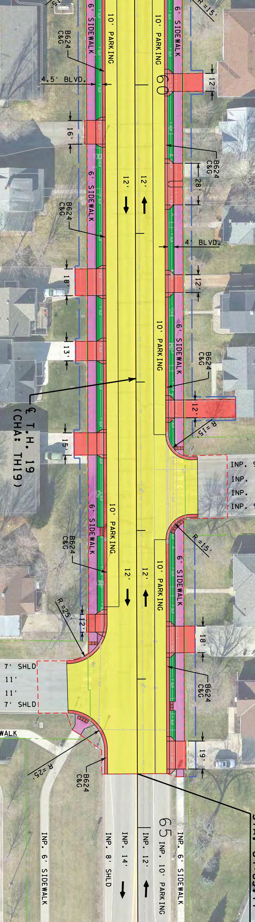
11 2.3 Roadway Existing Conditions: The existing roadway right-of-way (ROW) is 66 feet wide. The average width from building face to building face in the downtown corridor is 70 feet. The existing roadway surface varies between 50 feet-wide in the downtown business corridor and 44 feet-wide on the segment east of Columbus Avenue (see Exhibits C1 through C4). An original concrete pavement was installed circa 1931 and is still present below the existing bituminous pavement. The last significant improvements were in 1990 when the curb extensions, brick boulevards and decorative lighting were added and the road surface was overlaid. Proposed Improvements: The new roadway is proposed to be constructed as a concrete pavement section throughout the project corridor. Following considerable discussion between MnDOT and City staff, the recommended roadway width is proposed to be 44 feet, which will accommodate two driving lanes and 2 parking lanes. The narrower roadway width in the downtown corridor will result in a sidewalk corridor 3 feet wider for pedestrians on each side of the roadway. On average the space outside the curb will be 13 feet between the curb line and building face in the downtown corridor. As part of the preliminary design, a proposed geometric layout, (see Exhibit E, Sheets 1 through10) has been prepared and has been submitted to MnDOT District 7 and MnDOT Central Office for review and approval before final plans and bidding documents can be prepared. Final MnDOT layout approval is anticipated in June The majority of roadway improvements are a MnDOT cost. Under the State s cost participation policy, a portion of the roadway cost for parking, sidewalks, lighting and landscaping are a city eligible roadway cost. Funding for the city s share will come from a combination of assessments, state aid funds, federal STP grant, and/or City tax levy Intersection Traffic Control Existing Conditions: There are three major intersections along the Main Street/TH19 corridor: 1. TH 21 - Currently 4-way stop 2. First Street SE (CSAH 60) - Currently traffic signal 3. Columbus Avenue E (CSAH 15) - Currently 2-way stop on the Columbus legs The 2015 average daily traffic (ADT) volumes were estimated at 8,360 vehicles per day, with approximately 440 (5 percent) estimated to be heavy commercial vehicles. Average Daily Traffic on Main Street is estimated to grow to over 12,000 vehicles per day by Consideration was given to future traffic growth and the need to control traffic and maintain mobility in the corridor. Proposed Improvements: Intersection Control Evaluation (ICE) studies have been completed to review proposed intersection traffic control now and into the future. Based on the study recommendations, two mini-roundabouts are proposed on Main Street; at the intersections of First Avenue SE (Le Sueur County CSAH 60) and at Columbus Avenue E (Scott County CSAH 15). Layouts of the proposed mini roundabouts can be seen in Exhibit E, Sheets 5 and 6. The proposed mini-roundabouts as shown will fit within the existing right-of way, with the exception of a small sliver of right-of-way proposed from one adjacent property (see Section 3 below). o intersection improvements are proposed at the TH 21 intersection with this project as the intersection will be critical for the detour and maintaining mobility during construction. FEASIBILIT REPORT EWPR Page 4
12 Costs of the mini-roundabouts will be apportioned based on the State s cost participation policy, which would be split between MnDOT (4 legs), City (2 legs), Scott Co. (1 leg), and Le Sueur Co. (1 leg). Funding for the City s share would be a combination of state aid funds, federal STP grant, and/or City tax levy Railroad Crossing Existing Conditions: The UPRR operates a shortline track and spur line that serves Miller Milling in ew Prague. The track also extends south of ew Prague to Seneca in Montgomery. The existing concrete crossing pads are showing signs of deterioration and are in need of replacement prior to the roadway improvements. Sanitary sewer and water main cross under the railroad tracks. Proposed Improvements: At this time, MnDOT has entered into an agreement with the UPRR to replace the crossing pads. The work is tentatively scheduled to be completed in In addition to the crossing pad improvements, the existing crossing signals and signal arms will require upgrade and relocation to meet current standards and to fit the proposed roadway geometry. The signal work will be completed by UPRR forces and is likely to take place during the project in 2020, or could be completed the season before in Parking Costs for the crossing pads and signal system improvements are a MnDOT cost. Existing Conditions: Parking in the downtown and availability of parking may have been the most significant item of discussion for the project stakeholder committee as well as item of debate between MnDOT and City staff. Parking in the corridor will remain much as it is today, with the exception of the parking widths proposed in the downtown corridor, which will be narrowed from approximately the existing14 foot parking lane today to a 10 foot parking lane in the future. Proposed Improvements: The resulting street width, as noted above, is proposed to be 44 feet wide with two 12 foot driving lanes and two 10 foot parking lanes. MnDOT traffic engineers had recommended a narrower parking lane, while City staff preferred a wider parking lane. The compromise was the 44 foot wide roadway with the 10 foot parking lanes. A narrower parking lane and street will statistically slow traffic. Exhibit D illustrates the feel of 10 foot, 11 foot, and 12 foot parking widths. The narrower parking width will result in a wider sidewalk space for pedestrians. The majority of the parking costs are a MnDOT cost item; however, per the State s cost participation policy, a portion of the parking lane costs are a city cost which will be funded by a combination of assessments, state aid funds, federal STP grant, and/or City general levy Sidewalks Existing Conditions: Existing sidewalks are present along the entire corridor. The exception is at the railroad crossing where the pedestrian access route (PAR) is not well defined. Most of the sidewalks in the downtown corridor are weathered, deteriorated and few locations would meet current ADA standards and therefore will require replacement. Proposed Improvements: Sidewalks are proposed to be replaced on both sides of Main Street along the entire length of the project. Pedestrian ramps will be constructed to meet current ADA FEASIBILIT REPORT EWPR Page 5
13 standards. The narrower parking lanes will result in a wider, more pedestrian friendly Pedestrian Access Route (PAR). The resulting PAR will be approximately 3 feet wider on each side of the roadway than exists today. See Exhibit E, Sheets 1 through 10 for extent of sidewalk replacements. The majority of the sidewalk costs are a MnDOT cost item; however, per the State s cost participation policy, a portion of the sidewalk costs are a City cost which will be funded by a combination of state aid funds, federal STP grant, and/or City general levy Driveways/Access Closures Existing Conditions: There are a number of existing driveways and curb cut openings that do not appear to be needed. Removal of unneeded accesses will result in additional parking and improve safety by reducing conflict points. Proposed Improvements: Working with MDOT traffic staff, the PMT has identified a number of driveway locations that the design team feel can be abandoned and removed. There are other drive openings that are recommended for removal, but which require more discussion with property owners and ultimately with MnDOT staff to close or allow to remain open. The current layout drawing (Exhibit E) illustrates the drives to be removed and which are noted with a CLOSE or CLOSE? on the layout drawing at those locations. Costs for driveway apron and access removals or restorations will be part of the overall roadway cost and apportioned between city and MnDOT based on the State s cost participation policy Lighting Existing Conditions: The existing lighting system along most of the corridor dates back to the 1990 project. The existing light fixtures are inefficient under today s current standards, are weathered and are costly to maintain or replace. Perpetuating the current lighting facilities is not an option with the proposed roadway improvements. Proposed Improvements: ew lighting fixtures and a new lighting system is proposed to be incorporated with the proposed roadway improvements. Capital cost for the improvements are part of the project cost. MnDOT will cover a portion of standard lighting. The remaining costs for additional fixtures and aesthetic fixtures is a City cost. An exact fixture has not yet been determined, but a concept fixture is illustrated in the Downtown Concept View, Exhibit F. MnDOT funding for lighting is limited to a base level of lighting at key intersections. The majority of the cost for lighting and decorative lighting is a City cost. Funding for the City share of these costs will come from a combination of assessments, federal STP grant, state aid funds, and/or City tax levy Landscaping/Streetscape Existing Conditions: During the 1990 project, the existing concrete brick pavers, bump outs, and street lighting was installed. The concrete pavers have deteriorated as a result of deicers and weather conditions. During the 2013 Central Avenue orth improvements, a superior clay paver system was implemented in an attempt to maintain the same Main Street paver theme on the block leading up to City Hall. FEASIBILIT REPORT EWPR Page 6
14 Proposed Improvements: While the clay pavers utilized in 2013 on Central Avenue are expected to perform better than the existing concrete pavers, the stakeholder committee has recommended that pavers not be utilized in the new design on Main Street. Specifics of the proposed landscaping and streetscape improvements are not known at this time, rather only concepts and priorities. Discussions with the project stakeholder committee have identified such community priorities as: concrete (colored or textured) accents, decorative lighting, flags/banners, planter boxes and/or hanging planters, benches, trash cans, and bike racks. More detailed landscape planning will occur over the next year and may involve additional individuals with specific interest in the subject. MnDOT funding for landscape improvements is rather limited with the majority of these costs a city cost. Funding for the City share of landscaping improvements will come from a combination of assessments, federal STP grant, state aid funds, and/or City tax levy. 2.4 Stormwater Management Existing Conditions: Storm sewer exists though out the corridor and drain off the TH 19 corridor into three subwatersheds: (1) Low point near 3 rd Avenue W which drains W under the UPRR tracks to Philips creek, (2) Central Avenue which drains north along Central Avenue and west to Philips Creek at a point south of 2 nd Street W, and (3) Memorial Park area which drains much of the easterly portion of the project south through Memorial Park to First Street SE and south/southwest to the upper Philips Creek system. Localized urban flooding has been observed in the field and confirmed and quantified from watershed modeling. The area of biggest concern is the low point area near 3 rd Avenue W. This area is impacted by various factors; large areas of impervious surface, downstream pipe capacity caused by poor and undersized pipes, upstream bypass flows caused by insufficient upstream storm sewer inlet capacities and stream elevation during large storm events. early all of the existing drainage structures are deteriorated beyond repair and will not fit the new design and therefore require full replacement. Proposed Improvements: Improvements will be confined mostly to the Main Street corridor. The exception is the replacement of a trunk storm sewer pipe which passes through a portion of Memorial Park from Main Street to the intersection of Lincoln Avenue SE and First Street SE. (See Exhibit G). A large 54 inch to 60 inch bored/jacked steel pipe casing will be installed under the UPRR to accommodate a large 36 inch to 42 inch storm sewer pipe. The greatest share of stormwater improvement costs are expected to be a MnDOT cost with a smaller portion to be a City cost based on watershed contribution. Funding for the City s share of these costs will come from the stormwater utility fund and/or state aid funds. 3 Rights of Way/Easements Only a small permanent easement is proposed to be acquired from St. Wenceslaus Church at the northwest quadrant of Main Street and Columbus Avenue to accommodate the roundabout geometry. FEASIBILIT REPORT EWPR Page 7
15 Temporary construction easements will be required from every property along the corridor. Temporary construction easements will provide space to work, space needed for matching adjacent grades, and connecting existing utility services. All right-of-way costs are expected to be a MnDOT cost with the exception of a potential utility easement for City/Utility Commission use. Any City costs for easements, would be funded by a combination of the respective utility funds, and/or City tax levy. 4 Required Permits and Approvals The following permits are anticipated to be needed: Union Pacific Railroad Subsurface crossings (Storm & Water Main) (not expected to be needed for sanitary as sanitary to remain and be lined). Minnesota Department of atural Resources (MDR) Outfall into Philips Creek Minnesota Department of Health (MDH) Water Main Minnesota Pollution Control Agency (MPCA) Construction Stormwater Permit MnDOT Cooperative Agreement 5 Cost Estimates and Project Funding The costs quoted herein are estimates only. The actual cost of the work would be determined through the public bidding process and a reconciliation of all project related costs. More detailed cost estimates are included in Appendix A. The cost estimates include budget amounts for construction cost and contingency (10 percent), as well as project related costs, such as administrative, legal, and engineering (20 percent). In addition, the City s estimated share of costs an estimate (8 percent) for fiscal and bonding and advance funding costs. Table 1 Estimated Project Cost Summary Improvement Estimated Cost Percent of Project Roadway Improvements $5,798,400 48% Streetscape/Landscaping/Lighting $2,672,500 22% Stormwater Improvements $801,100 7% Sanitary Sewer Improvements $894,500 7% Water System Improvements $1,200,700 10% Permanent and Temporary Easements $118,500 1% Fiscal/Bonding/Admin Costs $631,700 5% TOTAL $12,117, % FEASIBILIT REPORT EWPR Page 8
16 Source Table 2 Estimated Project Funding Sources Amount Percent of Project MnDOT $6,515,400 54% Scott and Le Sueur Counties $83,000 1% Federal ATP-7 STP Grant $1,770,000 15% Sanitary Sewer Fund $680,200 6% Water Utility Fund $901,200 7% Assessments $1,492,400 12% City General Levy and/or State Aid Funds $675,200 5% TOTAL $12,117, % Source Table 3 Estimated Contribution Breakdown Amount Percent of Project eighborhood Contribution (Assessments) $1,492,400 12% City-Wide Contribution* $2,256,600 19% Outside Contributions (Federal, State, Counties) $8,368,400 69% TOTAL $12,117, % *City-wide contribution includes; funding from the water, sewer, stormwater utility funds, Federal STP Grant, Municipal State Aid Funding, and City General Levy. 6 Proposed Assessments Based on the City of ew Prague s Assessment Policy for Street and Utility Improvements, the project will be funded in part through assessments to the benefiting properties with the balance of costs paid from sewer, water, and stromwater utility funds, as well as State Aid, Federal STP grant and general tax levy in addition to MnDOT funding. OTE: The recommended assessment rates for street improvements as presented in this report for the 2020 project are based on the 2014 assessment rates and the Consumer Price Index (CPI) change from 2014 to 2018 and extrapolated out to These are the assessment rates presented to the neighborhood as DRAFT at the April 26, 2018, neighborhood meeting. The proposed change in the street assessment rates, from the last reconstruction project in 2014 and proposed 2020 project, represents a 6.8 percent increase. It should be noted that historically on past City projects, all properties have been assessed on a unit basis based on a typical single family residential property flat rate assessment. However due to the large variety of commercial parcel sizes and large number of abnormally small commercial parcels, we have recommended implementing a hybrid method to assess the commercial/ industrial/multi-family parcels which applies the assessment based on an equivalent front foot method. This method was reviewed in detail with City staff and is presented in this report. Commercial/Industrial/institutional/Multi-Family parcels are still assessed at a rate 30 percent higher than single family parcels per the City s policy as they typically generate more traffic and benefit more from street improvements. Single family parcels are still proposed to be assessed FEASIBILIT REPORT EWPR Page 9
17 on the same unit basis as on past projects. The calculation of the non-residential assessment rate and the method of determining the front-foot assessment is illustrated on the assessment policy map in the appendix. Corner parcels would also be applied a corner credit such that up to 1/2 an equivalent unit would be credited to reduce the impact on corner parcels. In no case would a corner credit result in less than an equivalent 1/2 unit assessment being applied to the parcel. The estimated assessment rates and assessment methodology is presented in this report and was presented to property owners at the April 26, 2018, neighborhood meeting. It is recommended that the City s assessment policy be formalized to represent this modification to the policy. The estimated assessment rates are only preliminary at this time. It is anticipated that there will be little need to revise the street assessment rates; however, the assessment rates for water and sewer service improvements are estimated at this time and should be adjusted based on the final design estimates and the submitted bids in Assessments for water and sewer services are proposed to cover 100 percent of the cost of the water and sewer services. Street assessments only cover a fraction of the overall roadway costs as noted in the funding summary above. The assessment rates as presented in the preliminary assessment roll are as follows: Table 4 Preliminary Assessment Rates Improvement Estimated 2020 Rates 1 inch Water * (Setback Structure) Est. $2,000 - $2,300 / 1 inch Water * (Downtown Frontage) Est. $2,600 - $3,000 / 6 inch Commercial Water/Fire * (Downtown Frontage) Est. $5,900 - $6,600 / Sanitary Sewer * Est. $1,800 - $2,000 / Reconstruct Street, Curb & Gutter $8,500 / - Residential $ / FF - Commercial/ Institutional/Multi-Family *Actual Assessment Rate for water and sewer service improvements will be based on actual bid pricing plus project related costs. 7 Proposed Schedule and Future Steps The anticipated schedule is illustrated below. Table 5 Proposed Schedule Task Date Preliminary Design (Phase I) Council Ordered Preparation of a Feasibility Study October 3, 2016* Present Feasibility Study to Council & Order Public Hearing May 21, 2018* Hold Public Hearing/Council Orders Improvement June 4, 2018* Municipal Consent for Project June 4, 2018* Final Design (Phase II) Final Design, Plans, and Specifications July 2018 June 2019 Council Approves plans and Authorizes Ad for Bids September 2019* FEASIBILIT REPORT EWPR Page 10
18 Task Advertising for Bids October 2019 ovember 2019 Bid Opening December 2019 Council Approves Award of Bids January 2020* Date Construction Phase (Phase III) Construction April 2020 July 2021 Assessment Phase (Phase IV) Declare costs to assess and order assessment roll/hearing September 2020* Assessment Hearing October 2020* Assessments levied to Counties ovember 2020 * Milestones where City Council Actions/Resolutions are required 8 Summary and Recommendations From the results of the feasibility study and preliminary investigations, it can be concluded that: 1. The project is feasible as it relates to general engineering principles, practices, and construction procedures as it has been presented in this report. 2. The project is necessary to maintain the city s infrastructure. 3. The project is cost-effective when all related costs are considered - public and private. 4. The project has been identified in the City s Capital Improvements Plan (CIP) and MnDOT s State Transportation Investment Plan (STIP). We recommend the following: 1. Accept this feasibility report and order a public hearing to be held as soon as possible. 2. After holding the public hearing, the City Council should consider ordering the improvement and authorizing the preparation of plans and specifications. 3. The cost of the improvements will be recovered through assessments to the benefitted properties and through various other City contributions. 4. Pending MnDOT approval of the proposed layout; approve a resolution for Municipal Consent/Approval of the proposed Layout and enter into Phase 2 Joint Powers Agreement (JPA) with MnDOT for the final design and preparation of construction documents. 5. Update and adopt a formal assessment policy that reflects the proposed modifications to the assessment policy with respect to non-single family residential parcels. 9 Standard of Care The conclusions and recommendations contained in this report were arrived at in accordance with generally accepted professional engineering practice at this time and location. Other than this, no warranty is implied or intended. jb FEASIBILIT REPORT EWPR Page 11
 Exhibit F Downtown Concept View Exhibit G Memorial Park Preliminary Storm Sewer")
19 Exhibits Exhibit A SEH Letter to MnDOT Exhibit B Proposed Project Area Exhibit C Street Widths C1-Downton Street Width C2-Residential Street Width C3-Roadway Width C4 Sidewalk Design Exhibit D Consideration of Parking Width Exhibit E Layout and Utilities (Sheets 1-12) Exhibit F Downtown Concept View Exhibit G Memorial Park Preliminary Storm Sewer Alignment

20 February 18, 2013 RE: City of ew Prague, Minnesota Highway 19 through ew Prague SEH o. EWPR Glen Coudron MnDOT Project Manager MnDOT - District 7 Mankato 2151 Bassett Drive Mankato, M Dear Mr. Coudron: Thank you for your letter of January 29, 2013, regarding the tentative planning for a pavement maintenance project on Highway 19 (TH 19) in 2017 or We reviewed this subject with City Staff and can provide the following comments and thoughts at this time. First, on February 8, 2013, we provided you with the original plans that the City had on file for your review and to scan as needed, and to assist in compiling a history of past work along this segment of TH 19. We are aware that there is an old concrete pavement below the current bituminous surface and, based on available records, it appears that some or much of the concrete dates back to two different projects in 1931 and The most recent roadway improvements date back to 1989 when the street lighting, boulevard landscaping, and curb bump out work was done (see the plans provided earlier to you). There are currently concerns about the long-term condition of the street lighting and concrete paver systems installed in The concrete pavers in the boulevards have deteriorated as a result of roadway salt and are becoming a maintenance issue for the City. The City is currently planning to utilize a different paver system on future street projects. In the long-term, the Public Utility Commission would intend to install new, more efficient lighting systems with fewer poles and fewer light fixtures. Utilities, and the condition of the utilities, are by far the biggest concern to the City. The exiting sanitary sewer is old vitrified clay pipe (VCP), and based on city records the sewer appears to date back to We have not found any definitive records on the age of the water mains, but they likely date back to the same era or earlier. The water mains are old cast iron pipe and the City has experienced numerous water main breaks over the years on this segment of Main Street (TH 19). In addition, many of the water services are old lead service pipe and ultimately need to be replaced. At this time, the City has OT conducted any recent condition surveys of the sewer mains or water mains, nor have they evaluated the best method to rehabilitate those utilities. The sanitary sewer was last televised in the 1960 s. The City is planning to televise the sanitary sewer this summer and I am recommending that the City begin an evaluation of the condition of the water main and determine the best options to replace or rehabilitate the mains for the long-term. At this point, the utilities are the biggest variable and, in our opinion, a plan for rehabilitation is needed before any plans are decided with respect to the roadway. Engineers Architects Planners Scientists Short Elliott Hendrickson Inc., 12 Civic Center Plaza, Suite 2088, Mankato, M SEH is an equal opportunity employer fax Exhibit A
21 Glen Coudron February 18, 2013 Page 2 In our opinion, any work on the roadway deemed as pavement surface maintenance is only a short-term application due to the items described above. Below are comments to some of the other items you were looking for feedback about: Safety Concerns: othing in particular beyond the normal routine of construction issues. The biggest concern will be to pedestrians and access for Main Street businesses. Much of this will depend on the extent of work and the methods of construction required. Traffic Operations: The City is already experiencing a capacity issue with the traffic volumes on TH 13/19 (Main Street) as it passes through the heart of the downtown area. The volumes that presently use Main Street experience difficulty turning on and off the roadway and pedestrians must use caution in crossing this roadway. As indicated in the City s 2012 update to the Comprehensive Plan, the assessment of 2035 forecast traffic volumes indicate traffic demand on TH 13/19 in the downtown area will be experiencing traffic volumes that could result in operational deficiencies (LOS D or worse) if improvements or alternatives are not constructed. The forecast 12,300-12,800 trips along TH 13/19 in the downtown area coupled with on-street parking and numerous access points (both private drives and public streets) will likely result in unacceptable service levels in the future. Preserving the existing capacity should be studied along with long-term capacity expansion through the development of an alternative reliever route(s). Given the existing conditions along Main Street, any additional lanes do not appear possible without loss of on-street parking. Please refer to the City s Comprehensive Plan, Chapter 7, located on the City s website for more information. Work Planned on City and County Streets in the Same Timeframe: At this time we are not aware of any work proposed on Scott County CSAH 15 (Columbus Avenue), Scott County CSAH 37 (10th Avenue E), or Le Sueur County CSAH 60 (First Avenue SE); however, all three roadways are under consideration for jurisdictional turnbacks in the next few years, which may include some form of improvements to those roadways. Constraints on Construction Timing: There are two times of the year that the City of ew Prague utilizes Main Street: o Memorial Day parade. o The community celebration, Dožίnky Festival, is typically held the third weekend of September and utilizes Main Street. After you have had some time to review and compile this information, the City would like to meet with MnDOT District 7 staff to review options and long-term planning for TH 19/Main Street in ew Prague. In the meantime, please contact me with any questions or comments, or if you need additional information. Sincerely, SHORT ELLIOTT HEDRICKSO IC. Christopher M. Cavett, PE Consulting City Engineer c: Michael Johnson, City Administrator Glen Sticha, ew Prague Public Works Bruce Reimers, ew Prague Utility Commission p:\ko\n\newpr\109293\main street-th19-13 planning 2013\seh letter to mndot docx


22 Proposed Project Area Resurfacing Approx. 550 feet St. Wensceslaus Catholic Church Miller Milling Company Full Reconstruction Approx. 1 mile Memorial Park 7 th St SE ew Prague Golf Club Exhibit B


23 Hwy 21 to Columbus Ave BUILDIG BUILDIG SIDEWALK SIDEWALK DOWTOW STREET WIDTH Existing Condition PARKIG PARKIG TRAVEL LAE TRAVEL LAE BUILDIG SIDEWALK SIDEWALK PARKIG PARKIG TRAVEL LAE TRAVEL LAE


24 Columbus Ave to 7 th Ave SE RESIDETIAL AREA WIDTH Existing Roadway BOULEVARD SIDEWALK PARKIG TRAVEL LAE HOUSE PARK/LAW LAW SIDEWALK BOULEVARD PARKIG TRAVEL LAE


25 Roadway Width Existing width 50 between curbs in downtown core Proposed 44 Width


26 Sidewalk Design Frontage Zone* Pedestrian Access Route Amenity/Utility Zone 2 ADA Requires 6 Minimum Pedestrian Zone for Commercial Areas 2-3 *Frontage Zone distances may vary depending on location of MnDOT right-of-way 10 minimum


27 COSIDERATIO OF PARKIG WIDTH 10-foot Parking Width 11-foot Parking Width 12-foot Parking Width

28 Exhibit E

29

30

31

32

33

34

35

36
37

38

39


40 DOWTOW COCEPT VIEW Exhibit F


41
42 Appendix A Detailed Cost Estimate
43 Feasibility Study Preliminary Estimate of Probable Costs ew Prague TH 19 Mainstreet Reconstruction Project Estimate of Probable Costs SP Cost Breakouts Item Description s Cost Quantity Total MnDOT City of ew Prague City of ew Prague LeSueur/Scott County PAVIG AD GRADIG (P & G) COSTS (2016) Cost Eligible Cost on- Eligible Cost Cost otes 8.5" Concrete Pavement (1) sq yd $ ,111 $ 1,051,111 $972,156 $52,556 $26,400 A Milling of Mill/overlay segment sq ft $2.00 2,507 $ 5,014 $5,014 Overlay Bituminous ton $ ,204 $ 84,287 $84,287 4" Concrete Walk (within ROW) sq ft $ ,519 $ 303,836 $298,436 $0 $5,400 B 4" Concrete Walk (outside ROW) sq ft $ ,277 $ 77,746 $38,873 $38, B 8" Concrete Driveway Pavement sq yd $ ,252 $ 87,640 $87,640 Class 5 Aggregate Base (1) cu yd $ ,889 $ 117,333 $107,435 $5,867 $4,032 A Subgrade Excavation (1) cu yd $ ,556 $ 95,556 $90,778 $4,778 A Common Excavation cu yd $ ,815 $ 118,148 $106,961 $5,907 $5,280 A Common Borrow cu yd $ $ 1,472 $1,398 $74 A Muck Excavation cu yd $ ,000 $ 60,000 $60,000 Contaminated Soils lump sum $100, $ 100,000 $95,000 $5,000 A Curb and Gutter Design B624 lin ft $ ,559 $ 265,857 $261,257 $4,600 (a) Subtotal Paving and Grading $ 2,368,000 $2,209,234 $113,054 $0 $45,712 UTILITIES, REMOVALS, DRAIAGE, ETC. Removals/Clear and Grub 5.0% $ 118,400 $112,480 $5,920 A City Watermain (includes jack/bore) lump sum 1 $ 786,351 $786,351 City Sanitary Sewer (o jack/bore needed) lump sum 1 $ 585,783 $585,783 (b) Subtotal Utilities, Removals, Drainage, Etc. $ 1,490,534 $112,480 $5,920 $1,372,134 $0 DRAIAGE Storm Sewer 15.0% $ 355,200 $319,680 $35,520 A Jack/Bore Utilities Under RR per boring $150,000 1 $ 150,000 $135,000 $15,000 (c) Subtotal Drainage $ 505,200 $454,680 $50,520 $0 $0 STRUCTURES/SIGALS/MISC. COST Intersection ADA each $ 6, $ 222,000 $222,000 Temporary Signal System each $ 50, $ - Pedestrian Hybrid Beacons each $ 15, $ 30,000 $30,000 RR Crossing (ped & road signal system) lump sum $ 300, $ 300,000 $300,000 RR Crossing Resurface lin ft $ 1, $ 172,800 $172,800 Signing, Striping 7.0% $ 165, $165,760 Temp Traffic Control 7.0% $ 165, $157,472 $8,288 Erosion Control and Turf Establishment 5.0% $ 118, $112,480 $5,920 (d) Subtotal Misc. $ 1,174,720 $1,130,512 $44,208 $0 $0 Streetscaping Benches each $ 2, $ 35,000 $3,500 $31,500 Trash Receptacles each $ 1, $ 28,800 $2,880 $25,920 Bike Posts each $ $ 6,000 $600 $5,400 Built-in Planters each $ 25, $ 250,000 $25,000 $225,000 Concrete Special Colored Concrete sq. ft. $ ,869 $ 163,035 $16,304 $146,732 Planting Bed sq. ft. $ ,550 $ 33,788 $3,379 $30,409 Boulevard Trees each $ $ 33,000 $3,300 $29,700 Structural Soil cu. d. $ ,258 $ 81,770 $8,177 $73,593 Sidewalk Medallion each $ 5, $ 100,000 $10,000 $90,000 Decorative Fencing lin. ft. $ $ 66,000 $6,600 $59,400 (e) Subtotal Streetscaping $ 797,393 $79,739 $717,653 $0 $0 Lighting MnDOT Basic Roadway Lighting each $ 3, $ 95,700 $89,100 $6,600 Additional for aesthetic lighting each $ 8, $ 252,300 $252,300 City Additional Lighting each $ 12, $ 540,000 $540,000 (f) Subtotal Streetscaping $ 888,000 $89,100 $792,300 $0 $6,600 (a+b+c+d+e+f) Subtotal Construction $ 7,223,846 $4,075,745 $1,723,655 $1,372,134 $52,312 Risk & Contingency 10.0% $ 722,385 $407,574 $172,366 $137,213 $5,231 Mobilization 5.0% $ 292,586 $203,787 $86,183 $0 $2,616 (g) Subtotal Miscellaneous $ 1,014,970 $611,362 $258,548 $137,213 $7,847 (a+b+c+d+e+f+g) Total Construction $ 8,238,816 $4,687,106 $1,982,204 $1,509,347 $60,159 Administrative & Engineering 20.0% $ 1,647,763 $937,421 $396,441 $301,869 $12,032 RW and Fiscal Costs Temporary Easement Each $ $ 39,000 $39,000 Permanent Easement SQ FT $ $ 62,000 $2,000 $60,000 Total RW $ 101,000 $41,000 $0 $60,000 $0 Total Estimated Cost (2016 Dollars) $ 9,987,600 $5,665,528 $2,378,644 $1,871,217 $72,191 Total Estimated Cost (2020 Dollars) $ 11,485,700 $6,515,357 $2,735,441 $2,151,899 $83,019 City Advance Funding Fiscal / Bonding Costs (2020 Dollars) $ 631,700 $631,700 Total Estimated Project Cost (2020 Dollars) $ 12,117,400 $ 6,515,357 $ 3,367,141 $ 2,151,899 $ 83,019 City Total = $5,519,000 Cumulative Inflation Factor Used 1.15 (2016 to 2020 Construction ear) OTES: Assumed Cost Participation Policy: A - 95% MDOT /5% CIT OF EW PRAGUE (22' travel lanes, 20' parking, no additional parking - City covers 10% of parking costs) B - 100% MDOT (sidewalk within ROW), 50% MDOT / 50% CIT OF EW PRAGUE (sidewalk outside of ROW) P:\KO\\ewpr\139357\4-prelim-dsgn-rpts\43-prelim-dsgn\COST ESTIMATE_051118_for Feas Study.xls Revised on: 5/10/ :26 PM
44 Appendix B Preliminary Assessments B-1 Preliminary Assessment Rates B-2 Assessment Map B-3 Preliminary Assessment Roll
45 PRELIMIAR ASSESSMET RATES (DRAFT As recommended) May 21, 2018 MAI STREET IMPROVEMET PROJECT EW PRAGUE, MIESOTA SEH O. EWPR Improvements 1 Water * (Setback Structure) 1 Water * (Downtown Frontage) 6 Commercial Water/Fire * (Downtown Frontage) Estimated 2020 Rates Est. $2,000 - $2,300 / Est. $2,600 - $3,000 / Est. $5,900 - $6,600 / Sanitary Sewer * Est. $1,800 - $2,000 / Reconstruct Street, Curb & Gutter $8,500 / - Residential $ / FF - Commercial / Institutional / MF * Actual Assessment Rate for water and sewer service improvements will be based on actual bid pricing plus project related costs. P:\KO\\ewpr\139357\5-final-dsgn\Assessments\DRAFT 2020 Assessment Rates docx
46 * * * * * Corner Credit of up to 37.5' on corner non-residential parcels, (with total frontage to not be less than 37.5') ERCIAL / MULTI- FAMIL RATE X 1.3 IDUSTRIAL RATE X CIVIC CETER PLAZA SUITE 200 MAKATO, M PH EW ELSIA, PRAGUE, MIESOTA MIESOTA ASSESSMET POLIC MAP SEPT 14, 2015
47 Preliminary Assessment Roll for Feasibility Study PRELIMIAR ASSESSMET ROLL TH 19/MAI STREET IMPROVEMETS EW PRAGUE, MIESOTA o County Parcel o. ame1 ame2 Address 1 dres Le Sueur MILLER MILLIG COMPA LLC Le Sueur MILLER MILLIG COMPA LLC Le Sueur MILLER MILLIG COMPA LLC Le Sueur MILLER MILLIG COMPA LLC Le Sueur MILLER MILLIG COMPA LLC Le Sueur MKB IC Le Sueur RADOLPH J & LISA MARIE KUBES Le Sueur CHIA ROAL OF EW PRAGUE LLC C/O MARIA ELSO C/O RU JI ZHEG 7808 CREEKRIDG E CIR 7808 CREEKRIDG E CIR 7808 CREEKRIDG E CIR 7808 CREEKRIDG E CIR 7808 CREEKRIDG E CIR 103 3RD ST SE 1244 MOROE ST PO BOX 8084 West or East dres of PropertyAddress City Central State Zip Code Legal W 100 2D AVE SW MIEAPOLIS M Sect-03 Twp-112 Range AC THAT PART OF W 1/4 OF W 1/4 BEG 150 FT E & FT SW OF IT OF C.L. OF MAI Sect-03 Twp-112 Range AC W 100 2D AVE SW MIEAPOLIS M AT ITERSECTIO OF LIE OF SEC 3 & ORIGIAL RROW CTR- LIE, TH E 150 FT Sect-03 Twp-112 Range AC W 100 2D AVE SW MIEAPOLIS M O ITERSECTIO OF M HW 19 & E RROW,TH E70FT, SW356FT, W75FT, CIT OF EW PRAGUE Block AC W 100 2D AVE SW MIEAPOLIS M W 100 2D AVE SW MIEAPOLIS M BEAS RE-ARR/BLK 22 & 23 S 4.29 AC BLKS 22, 23 & 23 1/2 I BEA'S RE- ARRAGEMET OF BLKS 22 & 23 I SDICATE ADD CIT OF EW PRAGUE Block-002 LOT 1 W 100 MAI ST W EW PRAGUE M LESS W 19.66FT OF 110 FT & LESS W FT OF S 61.5 FT LESS S 8 FT FOR ALLE CIT OF EW PRAGUE Block-002 W W 102 MAI ST W SHAKOPEE M FT OF 110 FT OF LOT 1 & W 10 FT OF S FT OF LOT 1 & E 15 FT OF LOT 2 LESS S 8 FT FOR ALLE CIT OF EW PRAGUE Block-002 E 1/2 OF LOT 2 LESS E 15 FT LESS S 8 FT FOR ALLE W 106 MAI ST W MIEAPOLIS M Corner Lot? SF/MF/ / Front- Footage F-F F-F Corner Credit Assessment IST/ID? H/IDS () $4, $ $ $ $ $0.00 $4, H/IDS IDS $9, $ $ $ $ $0.00 $9, $10, $ $ $ $6, $1, $18, IDS (37.50) $20, $ $ $ $ $1, $22, IDS $2, $ $ $ $ $0.00 $2, Front-Foot Method Commercial - Institutional-MF Reconstructed Street Front-Foot Potenitial $ / F-F Residential Method SF Residential Recon- structed Street SF Residential Recon- structed Street $8, Per Setback 1- inch Water Setback 1- inch Water $2, Per $3, $ $ $ $ $1, $5, $5, $ $ $ $6, $1, $13, $4, $ $ $2, $ $1, $6, inch Bldg Front Water 1-inch Bldg Front Water $2,700 Per 6-inch Comm. Water 6-inch Commercial Water $6, Per Sanitary Sewer Sanitary Sewer $1, Per Total "Preliminary" Assessment 9 Le Sueur DE PROPERTIES LLC 803 1ST ST W CIT OF EW PRAGUE Block-002 W 1/2 OF LOT 2 LESS S 8 FT FOR ALLE W 110 MAI ST W EW PRAGUE M $6, $ $ $2, $ $1, $8, Le Sueur EW PRAGUE FLORAL Le Sueur IISFREE LLC Le Sueur IISFREE LLC Le Sueur IISFREE LLC Le Sueur RASMUSSO HOLDIG COMPA LLC 112 W MAI C/O 207 7TH JOSEPH J AVE SE GEIGER Le Sueur JOSHUA P MILLER 122 MAI ST W Le Sueur RADOLPH J & LISA TH MARIE KUBES AVE E Le Sueur RADOLPH J & LISA TH MARIE KUBES AVE E Le Sueur RADOLPH J & LISA MARIE KUBES Le Sueur RADOLPH J & LISA MARIE KUBES Le Sueur GREG DVORAK Le Sueur TERRACE J & MAR H FAHE Le Sueur TERRACE J & MAR H FAHE W 112 MAI ST W EW PRAGUE M CIT OF EW PRAGUE Block-002 LOT LESS W 10.1 FT & LESS S 8 FT FOR ALLE CIT OF EW PRAGUE Block-002 LOT 4 LESS S 8 FT FOR ALLE & LESS 42 FT W 114 MAI ST W (1) EW PRAGUE OF E 3 FT M C/O 207 7TH CIT OF EW PRAGUE Block-002 W 10.1 JOSEPH J AVE SE W 114 MAI ST W (2) EW PRAGUE M FT OF LOT 3 LESS S 8 FT FOR ALLE GEIGER C/O 207 7TH CIT OF EW PRAGUE Lot-004 Block-002 JOSEPH J AVE SE W 114 MAI ST W (3) EW PRAGUE M FT OF E 3 FT GEIGER 601 5TH ST CIT OF EW PRAGUE Lot-005 Block-002 E W 120 MAI ST W EW PRAGUE M LESS S 8 FT FOR ALLE CIT OF EW PRAGUE Lot-006 Block-002 W 122 MAI ST W EW PRAGUE M LESS S 8 FT FOR ALLE W 126 MAI ST W SHAKOPEE M CIT OF EW PRAGUE Lot-007 Block LESS S 8 FT FOR ALLE 128 MAI ST W? CIT OF EW PRAGUE Lot-008 Block-002 W (Vacant lot between SHAKOPEE M LESS 8 FT FOR ALLE 126 & 130) TH AVE E W 130 MAI ST W SHAKOPEE M CIT OF EW PRAGUE Block FT OF LOT 9 & LOT 10 LESS S 8 FT FOR ALLE TH CIT OF EW PRAGUE Block-002 1/2 OF W 130 MAI ST W SHAKOPEE M AVE E LOT 11 LESS S 15.2 FT FOR ALLE CIT OF EW PRAGUE Block-002 E 1/2 OF W 136 MAI ST W EW PRAGUE M STEVE LOT TH CIT OF EW PRAGUE Lot-013 Block-002 W 138 MAI ST W (1) EW PRAGUE M ST W LESS E 10 FT TH ST W W 138 MAI ST W (2) EW PRAGUE M CIT OF EW PRAGUE Block-002 W 1/2 OF LOT 12 & E 10 FT OF LOT $3, $ $ $2, $ $1, $5, RES DUPLEX/ TRIPLEX $5, $ $ $2, $ $1, $6, $1, $ $ $ $ $0.00 $1, $ $ $ $ $ $0.00 $ $5, $ $ $2, $ $1, $7, $5, $ $ $2, $ $1, $7, $5, $ $2, $ $ $1, $9, $3, $ $ $0.00 $0.00 $0.00 $3, $12, $ $ $ $6, $1, $20, $7, $ $2, $ $ $1, $11, $2, $ $ $2, $ $1, $4, (2.50) $5, $ $ $2, $ $1, $7, $4, $ $ $ $ $0.00 $4, PREPARED B: Short Elliott Hendrickson Inc. Page 1 of 7 Draft - May 11, 2018 Printed - 5/10/2018
48 Preliminary Assessment Roll for Feasibility Study PRELIMIAR ASSESSMET ROLL TH 19/MAI STREET IMPROVEMETS EW PRAGUE, MIESOTA o. 23 County Parcel o. ame1 ame2 Address 1 dres Le Sueur BRAIT ERCIAL ATT LLC RAFIK MOORE 212 MAI ST W West or East Zip Code dres of PropertyAddress City State Central Legal CIT OF EW PRAGUE Block AC THAT PART OF BLK 3,CIT OF EW PRAGUE: LOTS & 1/2 OF VAC ALLE ADJ & THAT PART OF LOT 9 & OF W 17.3FT OF LOT 10, BLK 3 LIG W 212 MAI ST W EW PRAGUE M OF E'L EXTESIO OF S LIE OF 1/2 OF LOT 3, BLK 21, SDICATE ADD & 50 FT OF E 8 FT OF LOT 12 & 50 FT OF LOTS & S 1/2 OF VAC ALLE ADJ Corner Lot? SF/MF/ / IST/ID? Front- Footage F-F Commercial - Institutional-MF Reconstructed Street Front-Foot Potenitial $ / F-F F-F Front-Foot Method Corner Credit Assessment Residential Method SF Residential Recon- structed Street SF Residential Recon- structed Street $8, Per Setback 1- Setback 1- inch Water inch Water $2, Per 1-inch Bldg Front Water 1-inch Bldg Front Water $2,700 Per 6-inch Comm. Water 6-inch Commercial Water $6, Per Sanitary Sewer Sanitary Sewer $1, Per Total "Preliminary" Assessment (37.50) $24, $ $ $ $6, $1, $32, Le Sueur MARTI J & AA L HERRMA Le Sueur ERIC J SKLUZACEK Le Sueur JEFF M & CID PICKA Le Sueur STEVE D & MAR ZARD Le Sueur MEDITERRAEA PROP LLC 107 2D AVE SW 1018 DEER RIDGE CT W 401 1ST AVE SE LAVOE 2948 CASCO PT RD W 218 MAI ST W? (West of 212 Broz Hotel) EW PRAGUE M SDICATE ADD Lot-001 Block AC & VACATED ALLE ADJOIIG (PARKIG LOT) SUCHOMEL ADD Block-001 LOT 1 LESS S W 400 MAI ST W LOSDALE M FT & LOT 2 LESS W 40 FT & LESS S 60 FT W 404 MAI ST W EW PRAGUE M SUCHOMEL ADD Lot-002 Block-001 W FT SUCHOMEL ADD Lot-003 Block-001 W 408 MAI ST W EW PRAGUE M W 410 MAI ST W WAZATA M SUCHOMEL ADD Lot-004 Block (37.50) $12, $ $ $ $6, $1, $19, (6.10) $5, $ $ $2, $ $1, $7, $5, $ $ $2, $ $1, $7, RES $5, $ $ $2, $ $1, $7, RES 4 OR MORE UITS $8, $ $ $2, $ $1, $10, Le Sueur GAR L & JUDITH A KOHOUTEK Le Sueur DERKSE DETISTR LLC Le Sueur RADOLPH J & LISA MARIE KUBES Le Sueur RADOLPH J & LISA MARIE KUBES Le Sueur RADOLPH J & LISA MARIE KUBES Le Sueur RADOLPH J & LISA MARIE KUBES Le Sueur GOLDSMITH PROPERTIES LLC Le Sueur RADOLPH J & LISA MARIE KUBES Le Sueur RADOLPH J & LISA MARIE KUBES Le Sueur RADOLPH J & LISA MARIE KUBES Le Sueur EW PRAGUE OFFICE SUPPL IC 502 COLUMBUS AVE S 101 LEXIGTO AVE S W 412 1ST ST SW? (Vacant lot west of 410) EW PRAGUE M SUCHOMEL ADD Lot-005 Block-001 WRABEK ADD Block-001 LOT 8-9 E 101 LEXIGTO AVE SEW PRAGUE M CIT OF EW PRAGUE Block-001 LOTS 10- MOROE ST E 104 MAI ST E SHAKOPEE M & 46 FT OF LOTS LESS E 19 FT OF LOT TH AVE E TH AVE E TH AVE E 112 1/2 MAI ST E TH AVE E E 106 MAI ST E SHAKOPEE M CIT OF EW PRAGUE Block-001 LOTS 9 & 12 E 108 MAI ST E SHAKOPEE M CIT OF EW PRAGUE Block-001 LOT 8 LESS E 8 ICHES & L0T 13 LESS E ICHES OF ORTH 30 FT I BLOCK 1 CIT OF EW PRAGUE CIT OF EW PRAGUE Lot-008 Block-001 E 110 MAI ST E SHAKOPEE M LOTS 7 & 14 & E 8 I, OF LOT 8 & E 8 I OF 30 FT OF LOT 13 E 112 MAI ST E EW PRAGUE M E 116 MAI ST E SHAKOPEE M CIT OF EW PRAGUE Lot-006 Block-001 W 35 FT OF LOTS 6 & 15 & W 16 ICHES OF 54 FT OF E 23 FT CIT OF EW PRAGUE Block-001 E 23 FT OF LOTS 6-15 LESS 7.27 X 23 FT TRIAGLE I SE COR TO CIT & LESS W 16 ICHES OF 54 FT OF LOT TH AVE E E 118 MAI ST E SHAKOPEE M CIT OF EW PRAGUE Block-001 LOT 5 & LOT 4 LESS E 20 FT & LESS PORTIO I SE COR & LESS PORTIO TO CIT TH CIT OF EW PRAGUE Block-001 E 20 FT AVE E E 120 MAI ST E SHAKOPEE M OF LOT 4 LESS PORTIO I SE COR & LESS PORTIO TO CIT 1177 CIT OF EW PRAGUE Lot-003 Block-001 MARDE CT E 122 MAI ST E JORDA M W FT OF 150 FT (Per Plat; not per parcel image on Beacon) $4, $ $2, $ $ $1, $8, (37.50) $9, $ $ $ $ $0.00 $9, (36.50) $5, $ $ $ $ $1, $7, RES $4, $ $ $2, $ $1, $6, $4, $ $ $2, $ $1, $6, RES $4, $ $ $ $6, $1, $12, RES $5, $ $ $2, $ $1, $7, RES $3, $ $ $2, $ $1, $5, $4, $ $ $2, $ $1, $6, $2, $ $ $2, $ $1, $4, $3, $ $ $2, $ $1, $5, Le Sueur JOH CA PRESERVE CT Le Sueur KEVI L CRAWFORD 126 MAI ST E E 124 MAI ST E SAVAGE M CIT OF EW PRAGUE Block FT OF LOTS 2 & 3 LESS W FT OF 150 FT OF LOT 3 CIT OF EW PRAGUE Lot-001 Block-001 1/2 E 126 MAI ST E EW PRAGUE M $6, $ $ $2, $ $1, $7, (12.00) $5, $ $ $ $ $1, $7, PREPARED B: Short Elliott Hendrickson Inc. Page 2 of 7 Draft - May 11, 2018 Printed - 5/10/2018
49 Preliminary Assessment Roll for Feasibility Study PRELIMIAR ASSESSMET ROLL TH 19/MAI STREET IMPROVEMETS EW PRAGUE, MIESOTA o County Parcel o. ame1 ame2 West or East Address 1 dres dres of Central PropertyAddress City Le Sueur SUEL PRITIG COMPA Le Sueur SUEL PRITIG COMPA Le Sueur HAROLD A & KATHLEE S SCHROEDER EW 200 MAI ST CIT OF EW PRAGUE Block-010 LOTS 6-7 PRAGUE E E 200 MAI ST E EW PRAGUE M TIMES EW PRAGUE TIMES State Zip Code 200 MAI ST CIT OF EW PRAGUE Lot-005 Block-010 E E 204 MAI ST E EW PRAGUE M /2 FT TH AVE SW Le Sueur SALO PAWS LLC 210 MAI ST E Le Sueur MARVI & LUA STICHA ZACHAR AVE Le Sueur MARVI & LUA STICHA Le Sueur MARVI & LUA STICHA Le Sueur WEALTH MAAGEMET BUILDIG LLC Le Sueur RODE P & MICHELLE TIETZ Le Sueur RODE P & MICHELLE TIETZ Le Sueur ATHO J & DIAE K KUBES Le Sueur EW PRAGUE UTILITIES Le Sueur D & R HARTMA PROPERTIES LLC Le Sueur BETHLAW REALT LLC Le Sueur CIT OF EW PRAGUE Le Sueur ASHLE GAUTHIER Le Sueur M MILLER PROPERTIES LLC ZACHAR AVE ZACHAR AVE 222 MAI ST E 603 LDALE AVE 603 LDALE AVE E 208 MAI ST E EW PRAGUE M Legal CIT OF EW PRAGUE Lot-004 Block-010 LESS E 30 FT CIT OF EW PRAGUE Lot-004 Block-010 E E 210 MAI ST E EW PRAGUE M FT LESS 57 SF OF E COR OF LOT 4 CIT OF EW PRAGUE Block-010 LOT 2 E 218 MAI ST E ELKO M LESS E 9 FT & E 9 FT OF LOT 3 & 14 X 80 FT S THEREOF CIT OF EW PRAGUE Block-010 LOT 3 E 218 MAI ST E ELKO M LESS E 9 FT & 64 X 160 FT S OF LOTS 2 & 3 LESS 14 FT OF E 80 FT E CIT OF EW PRAGUE 57 SF OF E COR 218 MAI ST E - ELKO M OF LOT 4 (Sliver Parcel) Corner Lot? E 222 MAI ST E EW PRAGUE M CIT OF EW PRAGUE Block-010 LOT 1 LESS E 21 FT & E 9 FT OF LOT 2 & 64 X FT S OF LOT 2 & 12 X 151 FT BETWEE LOTS 1 & 2 Sect-03 Twp-112 Range AC 66 X E 226 MAI ST E (1) EW PRAGUE M FT OF W 1/4 OF E 1/4 E 226 MAI ST E (2) EW PRAGUE M CIT OF EW PRAGUE Lot-001 Block-010 E 21 FT 202 VALLEVIE Sect-03 Twp-112 Range AC 65 X 93 FT OF W 1/4 OF E 1/4 W ST SW E 232 MAI ST E EW PRAGUE M CETRAL AVE E 300 MAI ST E EW PRAGUE SUSIDE ADD 1.06 AC W 50 FT OF LOT 5 LESS S 59 FT & LOT 6 LESS 22 X 14 M FT & LOT 7 BLK 11 SUSIDE ADD & PORTIO OF W 1/4 OF E 1/ (ELECTRIC LIGHT & POWER PLAT) 308 E MAI ST PRAIRIE GRASS DR W E 308 MAI ST E EW PRAGUE M Sect-03 Twp-112 Range AC X FT OF W 1/4 OF E 1/4 SUSIDE ADD Lot-001 Block-011 & X FT OF W 1/4 OF E 1/4 SEC E 316 MAI ST E PRIOR LAKE M ADJACET THERETO 118 CETRAL AVE E 400 MAI ST E EW PRAGUE SUSIDE ADD AC PART OF BLKS & S 1/2 OF BLK 3 M WRABEK ADD, & UPLATTED LADS I E 1/4 OF SEC AC 510 MAI ST E TH ST W E 510 MAI ST E EW PRAGUE M Sect-03 Twp-112 Range AC PART OF E 1/4 OF SEC 3, AT E COR, TH W ALOG LIE OF E 1/4, FT TO POB, TH S 248FT,E FT, FT TO LIE OF E 1/4, TH W 115 FT TO POB, SUBJECT TO EASEMET OVER 33 FT. Sect-03 Twp-112 Range AC 282 X E 514 MAI ST E SAVAGE M FT OF E 1/4 OF E 1/4 LESS W FT OF 182 FT SF/MF/ / IST/ID? Front- Footage F-F Commercial - Institutional-MF Reconstructed Street Front-Foot Potenitial $ / F-F F-F Front-Foot Method Corner Credit Assessment Residential Method SF Residential Recon- structed Street SF Residential Recon- structed Street $8, Per Setback 1- Setback 1- inch Water inch Water $2, Per 1-inch Bldg Front Water 1-inch Bldg Front Water $2,700 Per 6-inch Comm. Water 6-inch Commercial Water $6, Per Sanitary Sewer Sanitary Sewer $1, Per Total "Preliminary" Assessment (6.50) $5, $ $ $2, $ $1, $7, $6, $ $ $2, $ $1, $8, RES $5, $ $ $2, $ $1, $7, $4, $ $ $2, $ $1, $6, RES $ $8, $2, $ $ $1, $12, RES 1-3 UITS RES 1-3 UITS $12, $ $ $ $6, $1, $20, $ $ $ $ $ $0.00 $ $6, $ $2, $ $ $1, $10, $9, $ $2, $ $ $1, $13, $3, $ $ $ $ $0.00 $3, RES 1-3 UITS MUICIPAL PUBLIC SERVICE RES 1-3 UITS RES 1-3 UITS MUICIPAL PUBLIC SERVICE- OTHER HSTD RES RES 4 OR MORE UITS (27.50) $5, $ $ $ $ $1, $7, (37.50) $18, $ $ $ $ $0.00 $18, $21, $ $ $ $6, $1, $29, (37.50) $18, $ $ $ $ $1, $20, (37.50) $19, $ $ $ $ $0.00 $19, $ $8, $2, $ $ $1, $12, $23, $ $2, $ $ $1, $27, Le Sueur BRUZEK FUERAL HOME PROP LLC Le Sueur BRUZEK FUERAL HOME PROP LLC 104 LEXIGTO AVE S 104 LEXIGTO AVE S Le Sueur JOH & JULIE CLA TH ST E E 602 MAI ST E EW PRAGUE M E 610 MAI ST E EW PRAGUE M Sect-03 Twp-112 Range AC X FT OF E 1/4 OF E 1/4 BRUZEK SUB-DIV LOT 1 & LOT 2 LESS S 27 FT E 706 MAI ST E PRIOR LAKE M WRABEK ADD Block-001 LOTS 6 & 7 RES $ $8, $2, $ $ $1, $12, RES RES (37.50) $9, $ $ $ $6, $1, $17, $ $8, $2, $ $ $1, $12, PREPARED B: Short Elliott Hendrickson Inc. Page 3 of 7 Draft - May 11, 2018 Printed - 5/10/2018
50 Preliminary Assessment Roll for Feasibility Study PRELIMIAR ASSESSMET ROLL TH 19/MAI STREET IMPROVEMETS EW PRAGUE, MIESOTA o. County Parcel o. ame1 ame2 West or East Address 1 dres dres of Central PropertyAddress City 62 Le Sueur DAVID J ZVAOVEC 708 MAI ST E 63 Le Sueur KEETH J 710 MAI ST STEIMETZ E Le Sueur ATHA G & 712 MAI ST STEPHAIE L E 64 GROO State Zip Code Legal E 708 MAI ST E EW PRAGUE M WRABEK ADD Lot-005 Block-001 E 710 MAI ST E EW PRAGUE M WRABEK ADD Lot-004 Block-001 E 712 MAI ST E EW PRAGUE M WRABEK ADD Lot-003 Block-001 & W 1/2 LOT 2 Corner Lot? SF/MF/ / IST/ID? HSTD RES HSTD RES HSTD RES Front- Footage F-F Commercial - Institutional-MF Reconstructed Street Front-Foot Potenitial $ / F-F F-F Front-Foot Method Corner Credit Assessment Residential Method SF Residential Recon- structed Street SF Residential Recon- structed Street $8, Per Setback 1- Setback 1- inch Water inch Water $2, Per 1-inch Bldg Front Water 1-inch Bldg Front Water $2,700 Per 6-inch Comm. Water 6-inch Commercial Water $6, Per Sanitary Sewer Sanitary Sewer $1, Per Total "Preliminary" Assessment $ $8, $2, $ $ $1, $12, $ $8, $2, $ $ $1, $12, $ $8, $2, $ $ $1, $12, Le Sueur JOEL & SAM SUK WOLLI 716 MAI ST E E 716 MAI ST E EW PRAGUE M WRABEK ADD Lot-001 Block-001 & E 1/2 LOT 2 HSTD RES $ $4, $2, $ $ $1, $8, LE SUEUR COUT TOTALS $429, $63, $29, $64, $54, $100, $677, Scott VADA P LLC 5601 OAKLAW AVE Scott EVE PAR HOLDIGS IC Scott ZACK PROPERTIES LLC AVE 103 MAI ST E E 101 CETRAL AVE EDIA M Section 34 Township 113 Range 023 P/O SW1/4 COM ' W OF SE COR, W ', ', E 31.99', S ' TO POB. Subdivisioname ST WECESLAUS ADD E 102 1ST AVE E EW PRAGUE M Lot 002 Block 001 SubdivisionCd Section 34 Township 113 Range 023 SW1/4 COM SE COR, W ALOG S LIE ' TO E 103 MAI ST E EW PRAGUE M POB, W ALOG S LIE 25.69', ', E 26.52', S'ERL ' TO POB $4, $ $ $ $ $0.00 $4, $4, $ $ $ $ $0.00 $4, $3, $ $ $2, $ $1, $8, Scott SAD CREEK PROPERT HOLDIGS L Scott SAD CREEK PROPERT HOLDIGS L Scott CHARLES J & MICHELLE J TUP Scott WORSO & GOGGIS PROP LLC Scott ROALD & LISA HERTAUS 7575 LE SUEUR AVE E 105 MAI ST E (1) MOTGOMER M Section 34 Township 113 Range 023 COM 1442 LKS W OF SE COR SW1/4 W 20', 188', E 25', S 188' & S 164' OF W 3.5' ADJ TO EAST LE Block 00A Lot TCT SubdivisionCd SUEUR AVE E 105 MAI ST E (2) MOTGOMER M Subdivisioname RLS COLUMBUS AVE S Section 34 Township 113 Range 023 E 111 MAI ST E EW PRAGUE M Subdivisioname APEC ADD Lot 001 Block 001 SubdivisionCd MAI ST Section 34 Township 113 Range 023 E E 119 MAI ST E EW PRAGUE M Subdivisioname APEC ADD Lot 002 Block 001 SubdivisionCd DEAS DR Scott RBS COMPA LLC REDWIG AVE Scott MAR LEI ST E E 121 MAI ST E EW PRAGUE M Section 34 Township 113 Range 023 P/O SE1/4 SW1/4 COM SW COR WECESLAUS ADD, SE 23.25', W 30.49', SE 150', W 103', W 173.6', E TO POB. EX E 51' OF S 150' Section 34 Township 113 Range 023 COM SW COR OF 3-1 WECESLAUS ADD, SE 23.25', W 30.49', SE 150', W 103', W E 123 MAI ST E JORDA M ', E TO POB. EX W 52' EX COM SW COR OF 3-1 WECELAUS ADD, S 16.5' W 54.95' TO POB, W 26.2', S 157.1', E 25.75', ' TO POB. Section 34 Township 113 Range 023 SE1/4 SW1/4 COM SW COR 3-1 WECESLAUS E 123 MAI ST E PRIOR LAKE M ADD, S 16.50', W 54.94' TO POB, W 26.20', S ', E 25.75', ' TO POB $3, $ $ $2, $ $1, $8, $5, $ $ $ $ $0.00 $5, $10, $ $ $2, $ $1, $14, $6, $ $ $2, $ $1, $10, $8, $ $ $2, $ $1, $13, $4, $ $ $2, $ $1, $8, $4, $ $ $2, $ $1, $8, Scott ROUDBAK PO BOX 667 Scott ROUDBAK PO BOX 667 Scott ROUDBAK PO BOX 667 Scott CHURCH OF ST WECESLAUS Scott TUP HUGHES APARTMETS LLC Scott TUP HUGHES APARTMETS LLC Scott PJT REAL ESTATE SERVICES LLC Scott JOSEPH A PEROUTKA 215 MAI ST E 201 MAI ST E 201 MAI ST E 8116 TELEGRAPH RD 2178 PALACE AVE E 127 MAI ST E WASECA M Subdivisioname ST WECESLAUS ADD Lot 001 Block 001 SubdivisionCd EX W 15 I Subdivisioname ST WECESLAUS ADD E 125 MAI ST E WASECA M Lot 001 Block 001 SubdivisionCd W 15 I OF Section 34 Township 113 Range 023 COM E 125 MAI ST E WASECA M ' W OF SE1/4 SW1/4, 183', W 26.5', S 183', E 26.5' TO POB. E 215 MAI ST E EW PRAGUE M Subdivisioname ST WECESLAUS ADD Block 005 SubdivisionCd E 215 MAI ST E (1) EW PRAGUE M Subdivisioname ST WECESLAUS ADD Lot 001 Block 002 SubdivisionCd E 215 MAI ST E (2) EW PRAGUE M Subdivisioname ST WECESLAUS ADD Lot 002 Block 002 SubdivisionCd Section 34 Township 113 Range 023 COM E 301 MAI ST E BLOOMIGTO M ' E & 33' OF SW COR SE 1/4, E 89', 114.8', W 89', S 114.8' TO POB. Subdivisioname WERTISH ADD Lot 001 E 305 MAI ST E ST PAUL M Block 001 SubdivisionCd EX E 6' $2, $ $ $2, $ $0.00 $5, $2, $ $ $ $ $1, $4, $3, $ $ $2, $ $1, $8, CHURCH (37.50) $54, $ $2, $ $ $3, $60, (10.50) $5, $ $ $ $6, $1, $13, $5, $ $ $ $ $0.00 $5, (37.50) $7, $ $2, $ $ $1, $11, RES 1 UIT $ $8, $2, $ $ $1, $12, PREPARED B: Short Elliott Hendrickson Inc. Page 4 of 7 Draft - May 11, 2018 Printed - 5/10/2018
51 Preliminary Assessment Roll for Feasibility Study PRELIMIAR ASSESSMET ROLL TH 19/MAI STREET IMPROVEMETS EW PRAGUE, MIESOTA o County Parcel o. ame1 ame2 West or East Address 1 dres dres of Central PropertyAddress City Scott KARE L BUSTA 307 MAI ST Subdivisioname WERTISH ADD Lot 002 E E 307 MAI ST E EW PRAGUE M Block 001 SubdivisionCd & E 6' OF LOT 1 Scott DOALD D & JUDITH CO 309 MAI ST E Scott CTHIA ROCHEL 315 MAI ST E Scott BOW MIDWEST LLC WILLOW CT Scott ROBI A 403 MAI ST HERRMA E Scott BROCTER TH PROPERTIES LLC ST Scott TODD C & RACHAEL 902 SCHWEIGERT ECLIPSE PKW Scott BUILDIGS B TRACHTE IC WILLOW L Scott ROBLE A & CHARLETTE B GILDER Scott ROGER M MEER 503 MAI ST E Scott WALLACE R 505 MAI ST DEZER E Scott CURTIS LAMBRECHT PAAMA AVE Scott JULIE BECKER 509 MAI ST E Scott DAVID M & DAW E CLARK State Zip Code Legal E 309 MAI ST E EW PRAGUE M Subdivisioname WERTISH ADD Lot 004 Block 001 SubdivisionCd Subdivisioname WERTISH ADD Lot Block 001 SubdivisionCd SOUTH HALF OF LOT 4 BLOCK 1 WERTISH ADDITIO Subdivisioname WERTISH ADD Lot 005 E 315 MAI ST E EW PRAGUE M Block 001 SubdivisionCd EX 80' E 401 MAI ST E EW PRAGUE M Subdivisioname WERTISH ADD Lot Block 002 SubdivisionCd E 403 MAI ST E EW PRAGUE M Subdivisioname WERTISH ADD Lot Block 002 SubdivisionCd E 407 MAI ST E LE CETER M Subdivisioname WERTISH ADD Lot Block 002 SubdivisionCd Subdivisioname WERTISH ADD Lot 004 E 409 MAI ST E EW PRAGUE M Block 002 SubdivisionCd Subdivisioname WERTISH ADD Lot 005 E 411 MAI ST E EW PRAGUE M Block 002 SubdivisionCd MAI ST Subdivisioname WERTISH ADD Lot 001 E E 501 MAI ST E EW PRAGUE M Block 003 SubdivisionCd Subdivisioname WERTISH ADD Lot 002 E 503 MAI ST E EW PRAGUE M Block 003 SubdivisionCd E 505 MAI ST E EW PRAGUE M Subdivisioname WERTISH ADD Lot Block 003 SubdivisionCd Subdivisioname WERTISH ADD Lot 004 E 507 MAI ST E WEBSTER M Block 003 SubdivisionCd S 80' OF W 35' OF Subdivisioname WERTISH ADD Lot 4&5 E 509 MAI ST E EW PRAGUE M Block 003 SubdivisionCd S 105' OF LOT 4 & W 14' OF S 105' OF LOT 5 EX S 80' OF W 35' OF MAI ST Subdivisioname WERTISH ADD Lot 005 E E 511 MAI ST E EW PRAGUE M Block 003 SubdivisionCd E 50' OF S 105' OF Scott MATTHEW J DAVIS 601 MAI ST Subdivisioname WERTISH ADD Lot 001 E E 601 MAI ST E EW PRAGUE M Block 004 SubdivisionCd EX 80' OF Corner Lot? SF/MF/ / IST/ID? Front- Footage F-F Commercial - Institutional-MF Reconstructed Street Front-Foot Potenitial $ / F-F F-F Front-Foot Method Corner Credit Assessment Residential Method SF Residential Recon- structed Street SF Residential Recon- structed Street $8, Per Setback 1- Setback 1- inch Water inch Water $2, Per 1-inch Bldg Front Water 1-inch Bldg Front Water $2,700 Per 6-inch Comm. Water 6-inch Commercial Water $6, Per Sanitary Sewer Sanitary Sewer $1, Per Total "Preliminary" Assessment HSTD RES 1 UIT $ $8, $2, $ $ $1, $12, HSTD RES 1 UIT $ $8, $2, $ $ $1, $12, HSTD RES 1 UIT $ $4, $2, $ $ $1, $8, RES 1 UIT $ $4, $ $ $ $0.00 $4, HSTD RES 1 UIT $ $8, $2, $ $ $1, $12, RES 1 UIT $ $8, $2, $ $ $1, $12, RES 1 UIT $ $8, $2, $ $ $1, $12, (26.50) $5, $ $ $ $ $0.00 $5, RES 1 UIT $ $4, $ $ $ $1, $6, HSTD RES 1 UIT $ $8, $2, $ $ $1, $12, HSTD RES 1 UIT $ $8, $2, $ $ $1, $12, RES 1 UIT $ $8, $2, $ $ $1, $12, HSTD RES 1 UIT $ $8, $2, $ $ $1, $12, HSTD RES 1 UIT $ $4, $2, $ $ $1, $8, HSTD RES 1 UIT $ $4, $2, $ $ $1, $8, Scott GLE R RIES 603 MAI ST E Scott CHRISTOPHER COFIRM 605 MAI ST HOHEISEL OWER: E Ken & Cindy Johnson? Scott ROALD A JOHSO Scott DAIEL C VA LITH 109 LEXIGTO AVE Scott PATRICIA J SOLHEID Subdivisioname WERTISH ADD Lot 002 E 603 MAI ST E EW PRAGUE M Block 004 SubdivisionCd S1/2 OF Subdivisioname WERTISH ADD Lot 003 Block 004 SubdivisionCd W 60' OF E 605 MAI ST E EW PRAGUE M MAI ST Subdivisioname WERTISH ADD Lot 3&4 E E 607 MAI ST E EW PRAGUE M Block 004 SubdivisionCd E 4' OF 3 & W 62' OF ROLLIG MEADOWS L S 208 1/2 1 ST S Scott BOHUK PROPERTIES IC Scott RA S MILLER 707 MAI ST E Scott MARGARET J ST SE SHETKA Scott CTHIA F GILES 711 MAI ST E Scott CTHIA F GILES 711 MAI ST E Scott CTHIA F GILES 711 MAI ST / E / Scott ICK JOHSO 801 MAI ST E E 609 MAI ST E EW PRAGUE M Subdivisioname WERTISH ADD Lot Block 004 SubdivisionCd & E 2' OF LOT 4 Subdivisioname WERTISH ADD Lot 001 E 703 MAI ST E EW PRAGUE M Block 005 SubdivisionCd & LOT 2 EX E 48' OF Subdivisioname WERTISH ADD Lot 002 E 705 MAI ST E MOTGOMER M Block 005 SubdivisionCd E 48' OF E 707 MAI ST E EW PRAGUE M Subdivisioname WERTISH ADD Lot Block 005 SubdivisionCd E 709 MAI ST E EW PRAGUE M Subdivisioname WERTISH ADD Lot Block 005 SubdivisionCd EX E 17' E 711 MAI ST E (1) EW PRAGUE M Subdivisioname WERTISH ADD Lot Block 005 SubdivisionCd E 17' OF E 711 MAI ST E (2) EW PRAGUE M Subdivisioname SURISE ACRES Lot O-L Block ABC SubdivisionCd Section 34 Township 113 Range 023 COM SE COR LOT 4 BLK 5 WERTISH ADD, E 711 MAI ST E (3) EW PRAGUE M ALOG E L 160', E 30', S 160', W 30' TO POB E 801 MAI ST E EW PRAGUE M Subdivisioname SURISE ACRES Lot 012 Block 004 SubdivisionCd HSTD RES 1 UIT HSTD RES 1 UIT $ $8, $2, $ $ $1, $12, $ $8, $2, $ $ $1, $12, HSTD RES 1 UIT $ $8, $2, $ $ $1, $12, RES 1 UIT $ $4, $2, $ $ $1, $8, RES 1 UIT RES 1 UIT HSTD RES 1 UIT RES 1 UIT HSTD RES 1 UIT HSTD RES 1 UIT HSTD RES 1 UIT HSTD RES 1 UIT $ $4, $ $ $ $0.00 $4, $ $8, $2, $ $ $1, $12, $ $8, $2, $ $ $1, $12, $ $8, $2, $ $ $1, $12, $ $ $ $ $ $0.00 $ $ $ $ $ $ $0.00 $ $ $8, $2, $ $ $1, $12, $ $4, $2, $ $ $1, $8, PREPARED B: Short Elliott Hendrickson Inc. Page 5 of 7 Draft - May 11, 2018 Printed - 5/10/2018
52 Preliminary Assessment Roll for Feasibility Study PRELIMIAR ASSESSMET ROLL TH 19/MAI STREET IMPROVEMETS EW PRAGUE, MIESOTA o County Parcel o. ame1 ame2 Address 1 dres Scott MARIO JIRAK 803 MAI ST E Scott GAR T STABER VERGUS AVE Scott MARK MICHEL & PIOEER SALOO 103 MAI ST W Scott RUSSELL J SIREK AVE W Scott CHARLES JEROME SVOBODA PO BOX 392 Scott TIMOTH O'EILL 111 MAI ST W Scott RURAL UICATIOS HOLDIG Scott RADOLPH J & LISA M H KUBES Scott DOUGLAS & PATT LAU Scott RADOLPH J & LISA M H KUBES Scott RADOLPH J & LISA M H KUBES Scott RADOLPH J KUBES Scott RADOLPH J KUBES 123 W 7 ST 1244 MOROE ST S 121 MAI ST W 1244 MOROE ST S 1244 MOROE ST S AVE E # AVE E # 100 Scott MICHAEL F RUZICKA 507 COTTOWO OD L E Scott MICHAEL F RUZICKA 507 COTTOWO OD L E Scott MICHAEL F RUZICKA 507 COTTOWO OD L E Scott KATHLEE M EBET & HELE C POM Scott KATHLEE M EBET & HELE C POM Scott WELLS FARGO BAK & C/O THOMSO Scott DEIS & DELORES POMIJE TRUST West or East dres of PropertyAddress City Central State Zip Code Legal E 803 MAI ST E EW PRAGUE M Subdivisioname SURISE ACRES Lot Block 004 SubdivisionCd Section 34 Township 113 Range 023 COM W 101 MAI ST W EW PRAGUE M 33' & 1648 LKS W OF SE COR SW1/4, O W LIE SIMMER ST 117', W 30', S 117', E 30' TO POB. W 103 MAI ST W EW PRAGUE M Section 34 Township 113 Range 023 COM 33' & 30' W OF PT 1648 LKS W OF SE COR SW1/4, 117', W 25', S 117', E 25' TO POB. Section 34 Township 113 Range 023 P/O SW1/4 SW1/4 COM LIE OF MAI ST AT W AVE W EW PRAGUE M PT 30' OF CL OF RR, W ', SW 70.21', SE ', E 50.15', S 167' TO LIE OF MAI ST., E 20.06' TO POB. Section 34 Township 113 Range 023 COM 33' OF PT LKS W OF SE COR W 105 MAI ST W EW PRAGUE M SW1/4, 117', W 37' S 117', E 37' TO POB & P/O SW1/4 COM 1205' W OF SE COR, 150', E 27.33' TO POB, S 117', W 2', W 117' TO POB Section 34 Township 113 Range 023 P/O SW1/4 COM SE COR, W ALOG S LIE W 111 MAI ST W EW PRAGUE M 1205' TO POB, E 29.33', 33' TO ROW MAI ST, W 2', 117', W 27.33', S 51.02', W 13.20', S 5.24', W 4', S 60.7' TO ROW MAI ST, W 34.02', S 33', E 50.32' TO POB Section 34 Township 113 Range 023 COM W 115 MAI ST W BLUE EARTH M 150' W OF PT 33' & ' W OF SE COR SW 1/4, W 35', 167', E 21', S 8', S 42 E 1.65', S 125' TO POB Section 34 Township 113 Range 023 P/O W 119 MAI ST W SHAKOPEE M SE1/4 SW1/4 COM 1648 LKS W & 2 RODS OF SE COR, W 168.5' TO POB, 189.3', W 47.3', S 189.3', E 47.3 TO POB. Section 34 Township 113 Range 023 P/O W 121 MAI ST W EW PRAGUE M SE1/4 SW1/4 COM 215.8' W OF COR OF MAI & CETRAL, W ', E 57', S TO POB. Section 34 Township 113 Range 023 COM W 123 MAI ST W SHAKOPEE M LKS W OF SE COR SW 1/4, W 30', 146', E 30', S 146' TO POB. Section 34 Township 113 Range 023 COM W 125 MAI ST W SHAKOPEE M LKS W OF SE COR SW1/4 W 30', 146', E 30', S 146' TO POB. Section 34 Township 113 Range 023 P/O SW1/4 COM IT S LIE 1 ST W & 1 AVE W, S OF E LIE 1 AVE W 222.7', E 31.5', W 131 MAI ST W SHAKOPEE M S 173.3' TO LIE MAI ST, E 31.7', 395.3' TO S LIE 1 ST W, W 63.2' TO POB. & COM 63.2 E OF E LIE 1 AV W, S 282.3', E 60', 83.7' Section 34 Township 113 Range 023 COM W 133 MAI ST W SHAKOPEE M 62' E OF SE COR BLK 1 PHILLIPS ADD, ', E 35.50', S 173,30', W 35.50' TO POB. Subdivisioname PHILIPPS ADD TO W 201 MAI ST W EW PRAGUE M PRAHA Lot 005 Block 001 SubdivisionCd Subdivisioname PHILIPPS ADD TO W 207 MAI ST W (1) EW PRAGUE M PRAHA Lot 004 Block 001 SubdivisionCd E 28' OF Subdivisioname PHILIPPS ADD TO W 207 MAI ST W (2) EW PRAGUE M PRAHA Lot 004 Block 001 SubdivisionCd E 29' OF W 38' OF AVE W W 215 MAI ST W EW PRAGUE M Subdivisioname PHILIPPS ADD TO PRAHA Lot 003 Block 001 SubdivisionCd W 50' OF S 165' OF AVE Subdivisioname PHILIPPS ADD TO W W 215 MAI ST W EW PRAGUE M PRAHA Lot 3&4 Block 001 SubdivisionCd E 16' OF LOT 3 & W 9' OF LOT 4 PO BOX Subdivisioname PHILIPPS ADD TO 2609 W 217 MAI ST W CARLSBAD CA PRAHA Lot 1&2 Block 001 SubdivisionCd Subdivisioname PHILIPPS ADD TO CIRCLE DR W 309 MAI ST W (1) EW PRAGUE M PRAHA Lot 4&5 Block 002 SubdivisionCd & E 18' OF LOT 3 Corner Lot? SF/MF/ / IST/ID? HSTD RES 1 UIT HSTD RES 1 UIT HSTD Front- Footage F-F Commercial - Institutional-MF Reconstructed Street Front-Foot Potenitial $ / F-F F-F Front-Foot Method Corner Credit Assessment Residential Method SF Residential Recon- structed Street SF Residential Recon- structed Street $8, Per Setback 1- Setback 1- inch Water inch Water $2, Per 1-inch Bldg Front Water 1-inch Bldg Front Water $2,700 Per 6-inch Comm. Water 6-inch Commercial Water $6, Per Sanitary Sewer Sanitary Sewer $1, Per Total "Preliminary" Assessment $ $ $2, $ $ $1, $4, $4, $ $2, $ $ $0.00 $6, $3, $ $ $2, $ $1, $8, $ $8, $ $2, $ $1, $13, $5, $ $ $2, $ $1, $10, $6, $ $ $2, $ $1, $10, $5, $ $ $2, $ $1, $9, $6, $ $ $2, $ $1, $11, $8, $ $ $2, $ $1, $12, $4, $ $ $2, $ $1, $9, $4, $ $ $2, $ $1, $9, $4, $ $ $2, $ $1, $9, $5, $ $ $ $ $0.00 $5, (28.50) $5, $ $ $2, $ $1, $10, $4, $ $ $2, $ $1, $8, $4, $ $ $ $ $0.00 $4, $7, $ $ $2, $ $1, $11, $3, $ $ $ $ $0.00 $3, (37.50) $13, $ $ $ $6, $1, $21, (37.50) $16, $ $ $2, $ $1, $21, PREPARED B: Short Elliott Hendrickson Inc. Page 6 of 7 Draft - May 11, 2018 Printed - 5/10/2018
53 Preliminary Assessment Roll for Feasibility Study PRELIMIAR ASSESSMET ROLL TH 19/MAI STREET IMPROVEMETS EW PRAGUE, MIESOTA o County Parcel o. ame1 ame2 Address 1 dres Scott DEIS & DELORES POMIJE TRUST Scott A MARIE HERTAUS CIRCLE DR West or East Zip Code dres of PropertyAddress City State Central Legal Subdivisioname PHILIPPS ADD TO W 309 MAI ST W (2) EW PRAGUE M PRAHA Lot 2&3 Block 002 SubdivisionCd E 44' OF LOT 2 & W 48' OF LOT 3 EX E 9 I OF LOT ST Subdivisioname PHILIPPS ADD TO W W 325 MAI ST W WEBSTER M PRAHA Lot 1&2 Block 002 SubdivisionCd E 23' OF LOT 1 & W 22' OF 2 Scott STEVE J DUBA Subdivisioname PHILIPPS ADD TO ST W W 329 MAI ST W MOTGOMER M PRAHA Lot 001 Block 002 SubdivisionCd EX E 23' Scott SSA&M IC 1020 MILDRED DR Subdivisioname MODIFIED PLAT OF PHILLIPPS ADD Lot 001 Block 003 SubdivisionCd W 401 MAI ST W RICHFIELD M Corner Lot? SF/MF/ / IST/ID? Front- Footage F-F Commercial - Institutional-MF Reconstructed Street Front-Foot Potenitial $ / F-F F-F Front-Foot Method Corner Credit Assessment Residential Method SF Residential Recon- structed Street SF Residential Recon- structed Street $8, Per Setback 1- Setback 1- inch Water inch Water $2, Per 1-inch Bldg Front Water 1-inch Bldg Front Water $2,700 Per 6-inch Comm. Water 6-inch Commercial Water $6, Per Sanitary Sewer Sanitary Sewer $1, Per Total "Preliminary" Assessment $13, $0.00 $0.00 $ $6, $1, $21, $6, $ $ $2, $ $1, $11, (5.50) $5, $ $ $2, $ $1, $10, $28, $ $2, $ $ $1, $32, Scott UIO PACIFIC RR COMPA & PRO Scott REGDOB IVESTMETS IC 1400 DOUGLAS STOP 1640 PO BOX 1776 W o Address OMAHA E W o Address BURSVILLE M RAILROAD PROPERT CIT OF EW PRAGUE $0.00 $ $2, $ $ $1, $4, Section 34 Township 113 Range 023 P/O SW1/4 SW1/4 BOUD O E B LIE 150' E OF RR, B LIE OF S 30' OF 2 ST, W B LIE 8.5' E OF RR SPUR TCT, S B CL OF MAI ST? $0.00 $ $ $ $ $0.00 $0.00 SCOTT COUT TOTALS $310, $187, $58, $67, $18, $108, $750, PROJECT TOTAL $740, $250, $88, $132, $72, $209, $1,492, PREPARED B: Short Elliott Hendrickson Inc. Page 7 of 7 Draft - May 11, 2018 Printed - 5/10/2018


54 Sustainable buildings, sound infrastructure, safe transportation systems, clean water, renewable energy and a balanced environment. Building a Better World for All of Us communicates a companywide commitment to act in the best interests of our clients and the world around us. We re confident in our ability to balance these requirements.
4APNOIPF Vh, YII PTC CITY COUNCIL AGENDA REPORT. Honorable Mayor and City Council Members. 8K TH 63 River Crossing Bridge Replacement Project
 City of RE 4APNOIPF Vh, X` W\ YII PTC ING, CITY COUNCIL AGENDA REPORT Council Meeting Date: September 26, 2016 To: From: Agenda Item: Honorable Mayor and City Council Members Ron Rosenthal, Engineering
Building Great Neighbourhoods BELLEVUE AND VIRGINIA PARK
 Building Great Neighbourhoods BELLEVUE AND VIRGINIA PARK This is Meeting 2 Unfortunately, some residents in Bellevue and Virginia Park received the wrong information for this public open house (Meeting
Brooklyn Boulevard (County Road 152) Reconstruction Project Phase I. OPEN HOUSE June 20, 2017
 Reconstruction Project Phase I. OPEN HOUSE June 20, 2017") Brooklyn Boulevard (County Road 152) Reconstruction Project Phase I OPEN HOUSE June 20, 2017 Brooklyn Boulevard (County Road 152) Phase I Project Partners Project Lead Other Project Partners include Brooklyn
Brooklyn Boulevard (County Road 152) Reconstruction Project Phase I OPEN HOUSE June 20, 2017 Brooklyn Boulevard (County Road 152) Phase I Project Partners Project Lead Other Project Partners include Brooklyn
2014 Street and Utility Improvement Project. Feasibility Report January 28, 2014
 2014 Street and Utility Improvement Project Feasibility Report January 28, 2014 Public Informational Meeting 22 residents from 17 properties signed in Questions about construction (FAQs) Eyebrow cul-de-sac
Americans with Disabilities Act Transition Plan for Public Right-of-Way Improvements
 Americans with Disabilities Act Transition Plan for Public Right-of-Way Improvements Prepared by: Public Works Department Engineering Division October 2015 Table of Contents Section I Introduction.. 3
Chapter 4: Funding and Implementation
 Chapter 4: Funding and Implementation 83 84 Cost Estimating Cost estimating is an iterative process. When a project is in the conceptual stage, preliminary cost estimates are also provided conceptually,
CITY OF KASSON TRANSPORTATION ALTERNATIVES KASSON SAFE ROUTES TO SCHOOL
 ve ha 8t G B A Mantorville Ave N 240th Ave 16th St NE 11th Ave NE K-M HIGH SCHOOL SUNRISE TRAIL TO MANTORVILLE MNTH 57 SUNSET TRAIL TO MANTORVILLE NE PARK 16TH ST NE TRAIL K-M ELEMENTARY SCHOOL K-M MIDDLE
Omaha s Complete Streets Policy
 Omaha s Complete Streets Policy (Adopted August 2015) VISION To create great places and enhance our quality of life, the City of Omaha will provide safe, accessible streets for all users. Complete Streets
Project Update May 2018
 Project Update May 2018 Dakota County, in cooperation with the City of Lakeville, is planning to reconstruct 202 nd Street West (County Road 50) from Holyoke Avenue to Cedar Avenue (County Road 23). 202
Living Streets Policy
 Living Streets Policy Introduction Living streets balance the needs of motorists, bicyclists, pedestrians and transit riders in ways that promote safety and convenience, enhance community identity, create
Item No. 14 Town of Atherton
 Item No. 14 Town of Atherton CITY COUNCIL STAFF REPORT CONSENT AGENDA TO: THROUGH: FROM: HONORABLE MAYOR AND CITY COUNCIL GEORGE RODERICKS, CITY MANAGER MICHAEL KASHIWAGI, COMMUNITY SERVICES DIRECTOR MARTY
East Downtown Tax Increment Reinvestment Zone (TIRZ) No. 15 Infrastructure Assessment Study
 No. 15 Infrastructure Assessment Study") East Downtown Tax Increment Reinvestment Zone (TIRZ) No. 15 Infrastructure Assessment Study Houston, TX Technical Memorandum April 15 th, 2009 Prepare by: 2950 North Loop West, Ste. 900 Houston, TX 77092
East Downtown Tax Increment Reinvestment Zone (TIRZ) No. 15 Infrastructure Assessment Study Houston, TX Technical Memorandum April 15 th, 2009 Prepare by: 2950 North Loop West, Ste. 900 Houston, TX 77092
MAG Town of Cave Creek Bike Study Task 6 Executive Summary and Regional Significance Report
 Page 1 MAG Town of Cave Creek Bike Study Task 6 Executive Summary and Regional Significance Report August 1, 2012 MAG Project #481 Page 2 Task 6 Executive Summary and Regional Significance Report Introduction
West Dimond Blvd Upgrade Jodhpur Street to Sand Lake Road
 West Dimond Blvd Jodhpur St to Sand Lake CSS Transportation Project Summary Municipality of Anchorage Project # 05 005 Project Manager: John Smith, P.E. (MOA PM&E) Project Administrator: Julie Makela,
CITY OF BLOOMINGTON COMPLETE STREETS POLICY
 CITY OF BLOOMINGTON COMPLETE STREETS POLICY POLICY OBJECTIVE: The City of Bloomington will enhance safety, mobility, accessibility and convenience for transportation network users of all ages and abilities,
Building Great Neighbourhoods BONNIE DOON
 Building Great Neighbourhoods BONNIE DOON We Are Here Today To Explain the Neighbourhood Renewal Process Show you the Westwood Preliminary Design Ask for local knowledge Highlight the Local Improvement
Preliminary Design of Wayzata Boulevard Improvements(CSAH 112)
") Project Area Map 6 COUNTY 112 COUNTY Preliminary Design of Wayzata Boulevard Improvements(CSAH 112) Public Open House Open House To Do List: Sign in Visit with Hennepin County staff and design team Learn
Project Area Map 6 COUNTY 112 COUNTY Preliminary Design of Wayzata Boulevard Improvements(CSAH 112) Public Open House Open House To Do List: Sign in Visit with Hennepin County staff and design team Learn
Highway 49, Highway 351 and Highway 91 Improvements Feasibility Study Craighead County
 Highway 49, Highway 351 and Highway 91 Improvements Feasibility Study Craighead County Executive Summary March 2015 Highway 49, Highway 351 and Highway 91 Improvements Feasibility Study Craighead County
Mark Malone, P.E. SD DOT
 Mark Malone, P.E. SD DOT SD10 Grading & Surfacing From 8 th Ave W to 8 th Ave E 1 mile plus transition lengths Complete Urban Reconstruction Grading, C&G, Storm Sewer, Sidewalk, Concrete Surfacing Railroad
BUDGET FOR RESEDA BOULEVARD, STREET RECONSTRUCTION / VISION ZERO PROGRAM, REPORT BACK, COUNCIL FILE
 FORM GEN. 160 (Rev. 11-02) CITY OF LOS ANGELES INTERDEPARTMENTAL CORRESPONDENCE Date: To: Honorable City Council From: Gary Lee Moore, City Engineer Bureau of Engineering 7%mt /Electronically signed by
Poor pavement condition Substandard Intersections. / Substandard bike/pedestrian/transit accommodations. Driveway access Environmental concerns
 Public Informational Meeting University Avenue (Allen Boulevard Segoe Road) March 23, 2011 City of Madison City of Middleton Village of Shorewood Hills Dane County Existing Roadway Conditions Poor pavement
City of Moorhead Committee of the Whole Meeting
 City of Moorhead Committee of the Whole Meeting Corridor Study Limits Center Avenue (Red River to 8th Street) TH 10 (Red River to TH 336) TH 75 (20th Ave S to Main Avenue) 2 Study Need: Project Overview
Street Paving and Sidewalk Policy
 City Commission Policy 600 Street Paving and Sidewalk Policy DEPARTMENT: Public Works DATE ADOPTED: June 7, 1995 DATE OF LAST REVISION: December 10, 2014 Policy No. 600.01 AUTHORITY: PASS City of Tallahassee-Leon
CONNECTIVITY PLAN. Adopted December 5, 2017 City of Virginia Beach
 CONNECTIVITY PLAN Adopted December 5, 2017 City of Virginia Beach CONTENTS 1.0 Background & Purpose... 2 2.0 Existing Inventory & Analysis... 3 ViBe District Existing Walking Conditions... 4 3.0 ViBe District
APPENDIX 2 LAKESHORE ROAD TRANSPORTATION REVIEW STUDY EXECUTIVE SUMMARY
 APPENDIX 2 LAKESHORE ROAD TRANSPORTATION REVIEW STUDY EXECUTIVE SUMMARY Appendix 2 City of Mississauga Lakeshore Road FINAL REPORT Transportation Review Study December 2010 EXECUTIVE SUMMARY Study Purpose
City of Madison, East Johnson Street North Baldwin Street to First Street Local Street Dane County
 City of Madison, East Johnson Street North Baldwin Street to First Street Local Street Dane County Public Involvement Meeting Thursday, November 10, 2016 5:30 to 7 P.M. Festival Foods 810 E. Washington
Ocean Park Boulevard Green Street Project Alternatives & Trade Offs
 Planning Commission March 4, 2009 Ocean Park Boulevard Green Street Project Alternatives & Trade Offs Purpose of Tonight s Meeting Review concept plans and options Provide input on alternatives and trade-offs
SAWS QA/QC CHECKLIST WATER ADJUSTMENT/RELOCATION PROJECTS
 SAWS QA/QC CHECKLIST WATER ADJUSTMENT/RELOCATION PROJECTS Project Name: SAWS Water Job No.: CSJ No. (if applicable): Date: AWS Consultant: PROJECT INFORMATION N/A Yes No Joint Bid (COSA/TxDOT) N/A Yes
BPP / SUB
 Development Services Department Project/File: Lead Agency: Site address: Millwell Place Subdivision/ BPP15-0031/ SUB15-0064 This is a preliminary plat application to allow for the development of 68 building
Final Sidewalk Feasibility Study
 Garfield Drive From Anastasia Drive to Elizabeth Place City of South Daytona July 23, 2009 Final Sidewalk Feasibility Study Prepared for: Prepared by: Final Sidewalk Feasibility Study Garfield Drive 2
Environment and Public Works Committee Presentation
 Mixed Use Centers Complete Streets Guidelines Project Environment and Public Works Committee Presentation December 10, 2008 Project Objectives: Conduct an inter-departmental and agency process to study
Old Dominion Drive (Route 309) Pedestrian Safety Project Phase II. North Glebe Road to 38 th Street N
 Pedestrian Safety Project Phase II. North Glebe Road to 38 th Street N") Old Dominion Drive (Route 309) Pedestrian Safety Project Phase II North Glebe Road to 38 th Street N Prepared: 12/2010 The presentation you are about to review represents a 90 percent completed design.
Old Dominion Drive (Route 309) Pedestrian Safety Project Phase II North Glebe Road to 38 th Street N Prepared: 12/2010 The presentation you are about to review represents a 90 percent completed design.
Item to be Addressed Checklist Consideration YES NO N/A Required Description Complete Streets Guidelines
 Passaic County Complete Streets Checklist - Concept Development Project Name Item to be Addressed Checklist Consideration YES NO N/A Required Description Complete Streets Guidelines Existing Plans Have
Atwood Avenue Fair Oaks Avenue Cottage Grove Road
 Atwood Avenue Fair Oaks Avenue Cottage Grove Road Agenda Purpose Review project scope & goals Present design alternatives Gather feedback Answer Questions Format Open House Presentation Q&A Open House
APPENDIX A: Complete Streets Checklist DRAFT NOVEMBER 2016
 APPENDIX A: Complete Streets Checklist DRAFT NOVEMBER 2016 Complete Streets Checklist MetroPlan Orlando s Complete Streets Checklist is an internal planning tool for staff to further implementation of
Building Great Neighbourhoods QUEEN ALEXANDRA
 Building Great Neighbourhoods QUEEN ALEXANDRA We are here today to Explain how the City is investing in improving your neighbourhood and how your neighbourhood will be improved to meet current City standards.
PROJECT NO. 093 MA 199 H C. FEDERAL NO. xxxx WIKIEUP-WICKENBURG-PHOENIX HIGHWAY TEGNER STREET, ALTERNATIVE 10 PROJECT IMPROVEMENT
 PROJECT NO. 093 MA 199 H 5807 01C FEDERAL NO. xxxx WIKIEUP-WICKENBURG-PHOENI HIGHWAY TEGNER STREET, ALTERNATIVE 10 PROJECT IMPROVEMENT (INTERSECTION IMPROVEMENT) US 93/US 60 FINAL PROJECT ASSESSMENT April
TRANSPORTATION & INDUSTRIAL ACCESS STUDY PHASE II GENESEE TRANSPORTATION COUNCIL
 TRANSPORTATION & INDUSTRIAL ACCESS STUDY PHASE II GENESEE TRANSPORTATION COUNCIL MONROE COUNTY VILLAGE SQUARE FINAL CONCEPT-LEVEL STRATEGY REPORT I. Introduction The purpose of this report is to recommend
IMPLEMENTATION STRATEGIES
 GEORGETOWN SIDEWALK MASTER PLAN 34% of funding is dedicated to Downtown Overlay District sidewalks 28% of funding is recommended within 1/4 mile of Southwestern University 26% of funding is recommended
RESOLUTION NO ?? A RESOLUTION OF THE CITY OF NEPTUNE BEACH ADOPTING A COMPLETE STREETS POLICY
 RESOLUTION NO. 2018-?? A RESOLUTION OF THE CITY OF NEPTUNE BEACH ADOPTING A COMPLETE STREETS POLICY WHEREAS, safe, convenient, and accessible transportation for all users is a priority of the City of Neptune
Welcome. Thank you for your interest in the Lewis & Clark Viaduct Concept Study
 Welcome Thank you for your interest in the Lewis & Clark Viaduct Concept Study Please use the arrows in the upper left hand corner to navigate through the presentation. Use the envelope icon to ask a question
Building Great Neighbourhoods LANSDOWNE
 Building Great Neighbourhoods LANSDOWNE We are here today to Explain how the City is investing in improving your neighbourhood and how your neighbourhood will be improved to meet current City standards.
City of Madison, East Johnson Street North Baldwin Street to First Street Local Street Dane County
 City of Madison, East Johnson Street North Baldwin Street to First Street Local Street Dane County Public Involvement Meeting Thursday, April 28, 2016 6 to 8 P.M. Lapham Elementary School 1045 E. Dayton
Tonight is for you. Learn everything you can. Share all your ideas.
 Strathcona Neighbourhood Renewal Draft Concept Design Tonight is for you. Learn everything you can. Share all your ideas. What is Neighbourhood Renewal? Creating a design with you for your neighbourhood.
Le Sueur County, MN Tuesday, December 13, 2016 Board Meeting
 Le Sueur County, MN Tuesday, December 13, 216 Board Meeting Item 8 1:15 a.m. Darrell Pettis, County Administrator / Engineer RE: Final CSAH 3 RE: CSAH 29 Speed Zone Study RE: 4H Utilities RE: Lake Jefferson
Executive Summary. September 3, 2014
 D Executive Summary September 3, 2014 Study Background and Purpose Citizens for Picture Rocks is a community advocacy group representing the Picture Rocks Fire Department, Pima County Sheriff s Department,
Fulton Market Streetscape
 Fulton Market Streetscape Ogden Avenue to Halsted Street Public Meeting Recommended Improvements December 10th, 2014 Meeting Purpose and Goals Present Existing Conditions Community Input and Charrette
Roadway Classification Design Standards and Policies. Pueblo, Colorado November, 2004
 Roadway Classification Design Standards and Policies Pueblo, Colorado November, 2004 Table of Contents Page Chapter 1. General Provisions 1.1 Jurisdiction 3 1.2 Purpose and Intent 3 1.3 Modification 3
M-58 HIGHWAY ACCESS MANAGEMENT STUDY Mullen Road to Bel-Ray Boulevard. Prepared for CITY OF BELTON. May 2016
 M-58 HIGHWAY ACCESS MANAGEMENT STUDY Prepared for CITY OF BELTON By May 2016 Introduction Missouri State Highway 58 (M-58 Highway) is a major commercial corridor in the City of Belton. As development has
Exhibit 1 PLANNING COMMISSION AGENDA ITEM
 Exhibit 1 PLANNING COMMISSION AGENDA ITEM Project Name: Grand Junction Circulation Plan Grand Junction Complete Streets Policy Applicant: City of Grand Junction Representative: David Thornton Address:
Legislative Update Williamsburg Residency
 Hampton Roads District Legislative Update Williamsburg Residency Jim Brewer, Resident Administrator 757-253-5140 Projects Under Way Warwick Boulevard Project http://www.warwickboulevard.org/ Contractors:
East Burke Transportation, Safety and Capacity Improvements
 East Burke Transportation, Safety and Capacity Improvements The purpose of this project is to increase mobility and improve safety for pedestrians, cyclists, and motor vehicles along VT Route 114 in the
WELCOME. City of Eden Prairie West 70 th Street
 WELCOME City of Eden Prairie West 70 th Street Project Schedule Sep Oct Nov Dec Jan Feb Mar Apr May Jun Jul Aug >>> May WEST SEGMENT Concept Plan Fall 2014 Plan Development Winter 2014 Summer 2015 Construction
S.R. 3009, Section A20 South Park & Logan Road Intersection Improvement Project
 Open House Public Meeting S.R. 3009, Section A20 South Park & Logan Road Intersection Improvement Project Municipality of Bethel Park, Allegheny County Bethel Park Municipal Building 5001 West Library
Building Great Neighbourhoods STRATHEARN
 Building Great Neighbourhoods STRATHEARN Public Involvement Community League Meeting #1: October 5, 2015 Public Meeting #2: March 15, 2016 Public Meeting #3: January 17, 2017 Building Great Neighbourhoods
New Measure A Expenditure Categories DEFINITIONS OF ELIGIBLE EXPENDITURES Adopted March 8, 2007
 New Measure A Expenditure Categories DEFINITIONS OF ELIGIBLE EXPENDITURES Adopted March 8, 2007 City Street and County Road Maintenance Program The preservation and keeping of public street and road rights-of-way
TRAFFIC ACTION PLAN. Laurie Meadows Neighborhood CITY OF SAN MATEO
 TRAFFIC ACTION PLAN Laurie Meadows Neighborhood CITY OF SAN MATEO Draft January 2017 Table of Contents Introduction... 2 The Traffic Forum Process... 5 Neighborhood Traffic Issues... 7 Neighborhood Recommendations
Henderson Ave. Complete Streets Project
 Henderson Ave. Complete Streets Project Meeting Purpose To finalize conceptual components of project prior to proceeding with preliminary engineering www.dallascompletestreets.wordpress.com MeetingAgenda
SECTION 3 STREET DESIGN
 3.01 GENERAL SECTION 3 STREET DESIGN For purposes of geometric and structural design, streets shall be classified according to the following table. The City Engineer will determine the class of all proposed
Non-Motorized Transportation 7-1
 Non-Motorized Transportation 7-1 Transportation facilities no longer mean just accommodating a vehicle powered by a combustion engine. Pedestrian and non-motorized facilities are important modes of travel
City of Gainesville Transportation/Roadway Needs PROJECT SUMMARY
 A1 Roadway Resurfacing $23,846,000 TYPE: Preservation of existing system Roadway resurfacing A2 Signal Replacement $6,000,000 TYPE: Preservation of existing system Replace traffic signals. B1 W 6th St
CSAH 101 Preliminary Design
 CSAH 101 Preliminary Design Public Open House No. 2 January 29, 2013 CSAH 62 to Hutchins Drive Welcome / Introductions Hennepin County Craig Twinem, Transportation Maury Hooper, Transportation Nick Peterson,
SD Highway 50 in Yankton (4 TH Street) Reconstruction Project NH 0050(99)381 PCN By Josh Larson McLaury Engineering Inc.
 Reconstruction Project NH 0050(99)381 PCN By Josh Larson McLaury Engineering Inc.") SD Highway 50 in Yankton (4 TH Street) Reconstruction Project NH 0050(99)381 PCN 6926 By Josh Larson McLaury Engineering Inc. Project Limits SD 50 from Broadway to Burleigh and from Marne Creek to Archery
SD Highway 50 in Yankton (4 TH Street) Reconstruction Project NH 0050(99)381 PCN 6926 By Josh Larson McLaury Engineering Inc. Project Limits SD 50 from Broadway to Burleigh and from Marne Creek to Archery
Design Criteria. Design Criteria
 F Design Criteria Design Criteria Ministry of Transportation Ministère des Transports DESIGN CRITERIA Page: 1 of 13 WORK PROJECT NO. N/A GO Bloomington Station TYPE OF PROJECT LOCATION Bloomington Road
Chapter 6: Transportation
 Chapter 6: Transportation I. INTRODUCTION The purpose of the Transportation Plan element of the Comprehensive Plan is to provide guidance to the City of North Mankato, as well as existing and future landowners
Executive Summary Route 30 Corridor Master Plan
 Route Corridor Master Plan Project Overview The Route Corridor Master Plan is a coordinated multimodal transportation and land use plan for the entire stretch of Route through East Whiteland Township,
CITY MANUALS AND STANDARDS REVIEW
 GEORGETOWN SIDEWALK MASTER PLAN CITY MANUALS AND STANDARDS REVIEW RESOURCES AND STANDARDS As part of the Master Plan process, a review and evaluation of current City documents and policies relevant to
Chapter 3: Multi-Modal Circulation and Streetscapes
 CHAPTER 3: MULTI-MODAL CIRCULATION AND STREETSCAPES Chapter 3: Multi-Modal Circulation and Streetscapes Overview Streetscape improvements have already been completed for Depot Street between Main Avenue
Water Street Promenade. Engineering and Design Services. Public Information Meeting No. 2. Education / Infrastructure / Innovation. Maplewood Avenue &
 Public Information Meeting No. 2 Water Street Promenade Maplewood Avenue & Engineering and Design Services Adjacent Areas July 16,2014Portsmouth, NH May 10, 2016 Education / Infrastructure / Innovation
Access requests to County streets and roadways are processed through one of the following methods:
 13.1 GENERAL APPLICATION PROCESS Access requests to County streets and roadways are processed through one of the following methods: A. Planned Developments may set general locations for access points.
APPROVE A RESOLUTION ADOPTING A COMPLETE STREETS POLICY
 STAFF REPORT MEETING DATE: September 13, 2016 TO: FROM: City Council Bob Brown, Community Development Director Russ Thompson, Public Works Director Patrick Filipelli, Management Analyst 922 Machin Avenue
Paul Huston, P.E., Design-Build Coordinator Chuck Gonderinger, HDR Engineering. Minnesota Department of Transportation (the Department)
") To: From: Paul Huston, P.E., Design-Build Coordinator Chuck Gonderinger, HDR Engineering Date: March 20, 2001 Subject: Roadway Geometric Design Criteria Project: TH 14/218 Design-Build Project, SP 7408-29,
To: From: Paul Huston, P.E., Design-Build Coordinator Chuck Gonderinger, HDR Engineering Date: March 20, 2001 Subject: Roadway Geometric Design Criteria Project: TH 14/218 Design-Build Project, SP 7408-29,
June 29, Dear Mr. Walter:
 From: CountyBoard@arlingtonva.us To: chickandsandy@msn.com Subject: County Board Response Regarding the Arlington Ridge Road Improvement Project (Intranet Quorum IMA00252707) Date: Wed, 29 Jun 2011 08:09:53-0400
Circulation in Elk Grove includes: Motor vehicles, including cars and trucks
 Circulation, as it is used in this General Plan, refers to the many ways people and goods move from place to place in Elk Grove and the region. Circulation in Elk Grove includes: Motor vehicles, including
PROPOSED BICYCLE AND PEDESTRIAN FACILITY Vicinity of Route 123/I-495 Interchange Tysons, Fairfax County, Virginia
 PROPOSED BICYCLE AND PEDESTRIAN FACILITY Vicinity of Route 123/I-495 Interchange Tysons, Fairfax County, Virginia PRELIMINARY ENGINEERING REPORT Prepared for: Prepared by: July 2017 Table of Contents 1
Southview Blvd & 3 rd Avenue Improvement Project. Public Open House December 4, to 7pm
 Southview Blvd & 3 rd Avenue Improvement Project Public Open House December 4, 2014 5 to 7pm Southview Blvd & 3 rd Avenue Public Information Meeting Agenda Presentation 5:30 to 6:15 pm Purpose of Project
BETHEL ROAD AND SEDGWICK ROAD CORRIDOR STUDY
 DRAFT PLAN City Council Meeting August 14, 2017 STUDY AREA Sedgwick Corridor State Route 160, principal arterial with Class 3 access management designation, commuter and freight route, connection to SR
Complete Streets Policy DAVID CRONIN, P.E., CITY ENGINEER
 Complete Streets Policy DAVID CRONIN, P.E., CITY ENGINEER Complete Streets City Commission adopted a Complete Streets policy in 2012 Complete Streets are road networks that are designed for all users:
City of Wayzata Comprehensive Plan 2030 Transportation Chapter: Appendix A
 A1. Functional Classification Table A-1 illustrates the Metropolitan Council s detailed criteria established for the functional classification of roadways within the Twin Cities Metropolitan Area. Table
TRANSPORTATION COMMISSION Agenda Staff Report
 TRANSPORTATION COMMISSION Agenda Staff Report Agenda Item No. 5.a DATE: JULY 31, 2014 TO: FROM: SUBJECT: TRANSPORTATION COMMISSION COMMUNITY DEVELOPMENT DEPARTMENT - PLANNING DRAFT OLYMPIC CORRIDOR PREFERRED
Proposed. City of Grand Junction Complete Streets Policy. Exhibit 10
 Proposed City of Grand Junction Complete Streets Policy Exhibit 10 1 City of Grand Junction Complete Streets Policy Vision: The Complete Streets Vision is to develop a safe, efficient, and reliable travel
City of Margate, Florida. Neighborhood Traffic Management Manual
 City of Margate, Florida Neighborhood Traffic Management Manual Table of Contents Page No. I. INTRODUCTION... 1 II. TRAFFIC CALMING REQUEST AND PROCESSING PROCEDURES... 2 1. COMPLETE AND SUBMIT PROJECT
20 minute presentation on proposed project. Comments and Questions following presentation. City of Madison
 20 minute presentation on proposed project Comments and Questions following presentation 2016 2017 Replace concrete pavement & base Replace curb and sidewalk as needed Proposed contra-flow bike lane Replace
122 Avenue: 107 Street to Fort Road
 : 107 Street to Fort Road November 24, 2015 4:30 8:00 p.m. Meeting Purpose Summarize project work completed to date Share results of public input from Phase 1 Share the draft concept plan and proposed
CHAPTER. Implementation
 CHAPTER Implementation 5 97 The previous chapters of the Guidelines dealt with the principles and elements of street design in Charlottesville, and this chapter covers the process of getting street projects
APPENDIX G: INTERSECTION NEEDS AT OKEECHOBEE BOULEVARD
 APPENDIX G: INTERSECTION NEEDS AT OKEECHOBEE BOULEVARD INTERSECTION NEEDS AT SR 7 and OKEECHOBEE BOULEVARD SR 7 Extension Project Development and Environment (PD&E) Study From Okeechobee Boulevard (SR
SR-203 Sidewalks and Town-Wide Mobility Improvements. Town Council Presentation September 7, 2016
 SR-203 Sidewalks and Town-Wide Mobility Improvements Town Council Presentation September 7, 2016 SR-203 Sidewalks and Town- Wide Mobility Improvements SR-203 Sidewalks and Appurtenances Town-Wide Mobility
Chapter 5 Future Transportation
 Chapter 5 Future Transportation The Future Land Use Plan identifies the desired land use designations. The land uses desired for Crozet depend, in large part, on the success of the transportation system,
ACTION TRANSMITTAL No
 Transportation Advisory Board of the Metropolitan Council of the Twin Cities DATE: January 12, 2018 TO: ACTION TRANSMITTAL No. 2018-12 TAC Funding and Programming Committee PREPARED BY: Joe Barbeau, Senior
This page intentionally left blank.
 This page intentionally left blank. COMMUNITY Coweta Community Overview Coweta Coweta, a residential community located in Wagoner County, is a suburb of Tulsa situated southeast of the metropolitan area
RZC Appendix 8A Marymoor Subarea Street Requirements
 RZC Appendix 8A Marymoor Subarea Street Requirements For additional design details for Marymoor Subarea infrastructure, refer to the 2017 Marymoor Subarea Infrastructure Planning Report. STREET REQUIREMENTS
Engineering - Bicycle and Pedestrian
 Capital Improvement Plan Project Summary # Bikeways Program 781,000 860,000 900,000 933,000 933,000 933,000 # Cannonball Path 1,200,000-780,000 - - - # Capital City Trail - 70,000 - - 910,000 - # Goodman
Le Sueur County, MN Tuesday, April 7, 2015 Board Meeting
 Le Sueur County, MN Tuesday, April 7, 2015 Board Meeting Item 7 9:50 a.m. Darrell Pettis, Administrator/Engineer RE: Ditch #16 Viewers RE: AET CSAH 3 Project Testing RE: Pumpkin Hill Right of Way Plat
AGENDA ITEM G-2 Public Works
 AGENDA ITEM G-2 Public Works STAFF REPORT City Council Meeting Date: 12/6/2016 Staff Report Number: 16-214-CC Regular Business: Approve the Oak Grove University Crane Bike Improvement Concept Plan, authorize
2011 Capital Projects University Area - Community Council Priority List Municipality of Anchorage
 2011 Capital Projects University Area - Community Council Priority List Municipality of Anchorage 2 Project Management and Engineering Projects on 40th Ave Extension - Lake Otis Pkwy to Dale St $18,103,000
WHITE STREET/ ENGLISH PLAZA STREETSCAPE IMPROVEMENT PROJECT
 WHITE STREET/ ENGLISH PLAZA STREETSCAPE IMPROVEMENT PROJECT 1 Project Goals 1 Improved Safety: Lighting, Multi-Modal Circulation, Emergency Access, Tripping Hazards; Stormwater 4 Environmental Performance:
WELCOME. Purpose of the Open House. Update you on the project. Present a draft recommended plan. Receive your input
 WELCOME Purpose of the Open House The Town of Smiths Falls has initiated the Beckwith Street Redevelopment Plan that includes the preparation of a streetscape functional design for the renewal of Beckwith
Bicycle Master Plan Goals, Strategies, and Policies
 Bicycle Master Plan Goals, Strategies, and Policies Mobilizing 5 This chapter outlines the overarching goals, action statements, and action items Long Beach will take in order to achieve its vision of
Preliminary Engineering Study
 Preliminary Engineering Study Open House # 2 June 6, 2018 PREPARED FOR: PREPARED BY: Agenda Background and status of preliminary engineering study County Road 26 design summary County Road 63 design summary
You are invited to an... OPEN HOUSE. Recommended Approach for the Franklin Avenue / East River Parkway Intersection
 You are invited to an... OPEN HOUSE Recommended Approach for the Franklin Avenue / East River Parkway Intersection Tuesday, August 25, 2009 6:30 to 8:30 pm St. Frances Cabrini Catholic Church 1500 Franklin