Prepared For: DIRECTION 2035 SHAPING OUR FUTURE SUMMARY REPORT JULY Prepared By: Staff to Bay County TPO
|
|
|
- Julie Morton
- 5 years ago
- Views:
Transcription


1 Prepared For: DIRECTION 2035 SHAPING OUR FUTURE SUMMARY REPORT JULY 2012 Prepared By: Staff to Bay County TPO
2 TPO Overview The Bay County Transportation Planning Organization (TPO) is a regional transportation planning agency created pursuant to Section , Florida Statutes. The Bay County TPO provides professional planning, coordinating, and advisory services for Bay County. The 18-member TPO Board is made up of elected officials from Bay County, Panama City, Callaway, Lynn Haven, Panama City Beach, Parker, Springfield, and Mexico Beach. Funding for the TPO comes from federal and state grants, member municipalities, and transportation agencies. The TPO partners with agencies, governments, and the public to identify and prioritize mobility needs, develop mobility plans and programs, seek and coordinate funding, and assemble resources through outreach and consensus building. The current federal transportation bill, Safe, Accountable, Flexible, Efficient Transportation Equity Act: A Legacy for Users (SAFETEA-LU), requires any census-defined urban area with a population of 50,000 or more to form a Transportation Planning Organization (TPO) and have an urban transportation planning process in place in order to receive federal transportation funding. Therefore, a primary objective of the Bay County TPO is to develop and update the Long Range Transportation Plan. Long Range Transportation Plan (LRTP) Overview A Long Range Transportation Plan (LRTP) serves as the blueprint that guides a region s transportation infrastructure development over at least a 20 year horizon. Future transportation needs of the region are evaluated in the LRTP. The TPO determines, collectively, how best to address these needs based upon anticipated funding. The planning process is designed to foster involvement by all interested parties such as the local business community, environmental organizations, community groups, and general public, through a proactive public participation process. This process is conducted by the TPO in coordination with the Florida Department of Transportation, transit operators, and local governments. The LRTP is updated every five (5) years and includes the following steps: Evaluating existing conditions affecting land use and transportation; Identifying and defining goals and objectives to guide transportation capital expenditure decisions; Forecasting future population and employment growth; Assessing projected land uses in the region and identifying major growth corridors; Identifying deficiencies and needs and analyzing and identifying various transportation improvement strategies; Analyzing and forecasting future revenue from existing sources and alternative revenue options; and Developing a plan that covers operating, maintenance, and system preservation costs as well as new capital investments Significant milestones and results of the update of the Bay County LRTP to the year 2035 are documented in the Summary Report. Goals and Objectives An important step in the development of the 2035 LRTP update is adoption of clearly defined goals and measureable objectives. The goals are policy statements of the Bay County TPO that guide the development of the 2035 Plan Update. The process includes a vision statement, mission statement, clearly defined goals, and a corresponding implementation strategy. These policies are important to the development of the plan update, as they serve as the basis for evaluating and selecting capital improvement projects for the plan. Using the previously adopted Goals and Objectives as a starting point to help develop the 2035 LRTP update, a Focus Group was convened to assist the TPO Staff in visioning for the 2035 LRTP update. The Focus Group was composed of 30 representatives from business, military, and community organizations that provided input to support regional growth and prosperity in Bay County over the next 20 years. The Focus Group, along with the TPO s Technical Advisory and Citizens Advisory Committees, developed the following vision and mission statements which were adopted by the TPO: Vision Statement Our vision is to provide a safe and efficient multimodal transportation system that supports the economic vitality of the area, protects the environment, promotes efficient system management and operation, and emphasizes the preservation of the existing transportation system. Mission Statement To enhance, for all people, the existing transportation system in manner that is safe, integrated, connected, socially responsible, coordinated with appropriate land use patterns, and supports economic development of the region.
3 The following nine goals were developed and used to guide the Bay County 2035 LRTP update: Goal 1: Plan and provide a multi-modal network of integrated, user-friendly transportation systems for the movement of people and goods. Goal 2: Provide connections between new developments to reduce short trips on the major road network. Goal 3: Develop and maintain a transportation system that provides for the safety of residents, visitors and commerce. Goal 4: Provide a coordinated transportation system that is efficient for everyone in both time and cost. Goal 5: Develop and maintain a responsible transportation system that protects, preserves, and enhances a high quality of life for all citizens, including but not limited to the protection and preservation of environmental, historical and recreation. Goal 6: Minimize transportation costs by coordinating land use and existing land conditions with appropriate transportation facilities. Goal 7: Be consistent with sustainable community principles: (1) Economic Development, (2) Environmental Protection, and (3) Social Equity. Goal 8: Develop and maintain a transportation system that provides for the security of residents, visitors and commerce. Goal 9: Develop and maintain a responsible transportation system that meets or improves on the national ambient air quality standards for all citizens and visitors. Public Involvement A comprehensive public outreach program was conducted as part of the 2035 LRTP update and involved a series of regional and community events, as well as online forums. The outreach was conducted to assist in the identification of future mobility needs and was aided by a Focus Group that met during the 2035 LRTP update to review the Goals & Objectives, the Draft Needs Plan, and the Draft Cost Feasible Plan. Additionally, a series of public workshops was held throughout the county to solicit input from the general public on the development of both the Needs and Cost Feasible plans. Comprehensive information from each step in the 2035 LRTP update was posted on the TPO's web site to allow citizens to review and offer feedback. The website for the 2035 LRTP update can be found at: Needs Plan An important step in the plan update is developing the Needs Plan. The Needs Plan defines the anticipated future transportation deficiencies and the capital improvement projects that would be necessary to alleviate all the deficiencies. The Needs Plan was prepared by comparing the projected population and land uses in the year 2035 to the existing transportation network. This comparison led to the identification of transportation projects that are needed in the future. These needs were presented at various public workshops held in 2010 where the public was provided the opportunity to suggest additional projects and remove previously identified projects. Based on input received at the public workshops, as well as input from agency staff, a Final Needs Plan was prepared and subsequently adopted by the TPO on December 15, The importance of freight movement was also recognized in the LRTP process. Therefore, freight movement was one of the evaluation criteria considered when ranking the Needs projects for inclusion in the Cost Feasible Plan. In April 2010, the TPO adopted a Regional Freight Network Plan which identified existing and future Highways of Commerce and transportation improvements needed to enhance the economic competitiveness in the region. The Freight Corridor Screening, a follow-up component of the Regional Freight Network Plan, was adopted in March The corridor screening was used to identify potential problems impacting trucking operations. In August 2011, the TPO staff received a request from Tyndall Air Force Base to add an interchange project at the base entrance on US. This request precipitated a formal Needs Plan amendment process that ultimately resulted in the TPO adopting the Needs Plan Amendment in September The Amended Needs Plan identified 40 roadway projects, 16 transit projects, several Bicycle/ Pedestrian, and Intelligent Transportation Improvement (ITS) projects that are needed by 2035 at a cost in excess of $3.2 billion in 2010 dollars. Financial Plan The revenues available through 2035 were forecast based on past funding and estimates of future funding. The Financial Resources Report outlined existing state and federal sources of revenue for funding transportation improvement projects, discussed alternative revenue sources that are available to local governments, and identified the procedures for estimating future revenues. The revenue
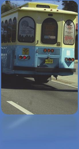
4 discussion was based on the historical trend of current transportation revenue sources. Financial projections were based on estimates of growth in the Panama City Urbanized Area through Funding estimated to be available in the Bay County TPO area through 2035 is approximately $370 million in 2010 dollars Cost Feasible Plan Although $3.2 billion of needs were identified, only $370 million of funding is estimated to be available for transportation improvements through Since the needs cannot be completely funded with available revenue, several cost feasible scenarios were developed. These scenarios demonstrated options for allocating the available revenue to best meet transportation needs. Following intensive evaluation by agency staff, along with interaction and feedback from the general public, a 2035 Cost Feasible Plan was selected and officially adopted by the TPO on July 27, Shortly after the adoption of the Cost Feasible Plan in July 2011, the TPO staff received requests to amend the Cost Feasible Plan. These requests precipitated a formal amendment process that was completed in January 2012, with the TPO adoption of the Cost Feasible Plan Amendment which included four additional projects. The amended 2035 Cost Feasible Plan represents a hybrid of the different scenarios and includes funding for 16 roadway projects, 2 transit/trolley projects, as well as annual allocations (termed box funds) for bicycle/pedestrian projects, Intelligent Transportation System (ITS) projects, Transportation System Management (TSM) projects, and transit improvements. COST FEASIBLE FUNDS Roadway Projects $ 312,913,658 Transit Projects $ 26,920,000 Box Funds: $ 36,750,000 ITS Projects (Capital Improvement, Operations and Maintenance) $450,000 Annually Bicycle / Pedestrian Projects $800,000 Annually Transportation System Management Projects $350,000 Annually Annual Public Transportation Capital Improvements $150,000 Annually Cost Feasible fund amounts are in 2010 dollars. Transit Development Plan During the preparation of the LRTP update, the Bay County TPO also conducted a Transit Development Plan (TDP) Update for , adopted in September The TDP update involved evaluation of existing transit and transportation disadvantaged operations. The TDP Update included extensive public outreach to the system users, incorporated a strategic focus and mission for transit services in Bay County, and guided the identification of future development of the transit system to meet the needs of the community. The transit needs and cost feasible transit projects identified in the 2035 LRTP update are shown on the included Transit Needs & Cost Feasible Map. Bicycle and Pedestrian Master Plan June Parallel to the 2035 LRTP update, the Bay County TPO, recognizing the benefits of bicycling and walking, completed an update of the Bicycle and Pedestrian Master Plan in A community-defined vision was established through citizen and agency participation in an intensive multi-day charrette. The vision and issues identified by the community were used to evaluate and prioritize projects in the Bicycle and Pedestrian Master Plan. This plan also includes an evaluation of existing bicycle and pedestrian conditions and policies, a review and analysis of vehicle crash data, and an implementation plan. Various bicycle and pedestrian projects needed within the TPO area were identified in the Bicycle and Pedestrian Master Plan. The 2035 Cost Feasible Plan includes funds for bicycle and pedestrian projects at $800,000 per year through Intelligent Transportation Systems (ITS) Intelligent Transportation Systems (ITS) is an application of management strategies and technologies to increase the efficiency and safety of the surface transportation system. Some of the benefits of ITS include: Reducing the time we spend stopped at red lights or waiting in traffic when an accident occurs. Giving us current, multi-modal information on travel conditions allowing us to make smarter choices about how, when, and where to travel. Giving us in-vehicle maps, guiding us to our destination, and improving safety by automatically notifying emergency services when and where an accident occurs. Helping transit agencies operate more efficiently and providing travelers with real time information that makes using transit easier and more attractive.
 Plan in September 2010. The 2035 Cost Feasible Plan includes $450,000 annual funding for ITS projects.")
 consisting of transit, bicycle/pedestrian,")

5 Helping commercial vehicle operators process paperwork associated with moving goods. Helping increase the efficient movement of freight and reducing the cost of moving goods to market. The TPO adopted the Regional Intelligent Transportation Systems (ITS) Plan in September The 2035 Cost Feasible Plan includes $450,000 annual funding for ITS projects. Summary The amended 2035 Needs Assessment identified 40 roadway projects and 16 potential transit projects. The amended 2035 Cost Feasible Plan includes 16 roadway projects, 2 transit/trolley lane projects, and 4 annual funding categories (termed box funds) consisting of transit, bicycle/pedestrian, Transportation Systems Management (TSM), and Intelligent Transportation Systems (ITS) projects. A project list and summary map identifying these projects is included on the reverse side. All 81 project segments from the Needs Plan, including 16 fully funded project segments plus 10 partially funded project segments from the Cost Feasible Plan, are shown on the Summary Map. For More Information The Bay County TPO welcomes your input, questions, and comments on the Long Range Transportation Plan (LRTP) and other planning activities of the TPO. The TPO's website contains information related to the Plan Update as well as other TPO documents including the various Master Plans referenced here. For questions or requests for additional information please contact the LRTP Project Manager: Mr. Gary Kramer (850) ext 219 gary.kramer@wfrpc.org West Florida Regional Planning Council 4081 E. Olive Rd - Suite A Pensacola, FL Website: Telephone: (850) , Toll Free: Fax: (850) W. 14th St - Suite E Panama City, FL 32401
6 Bicycle Priorities Map

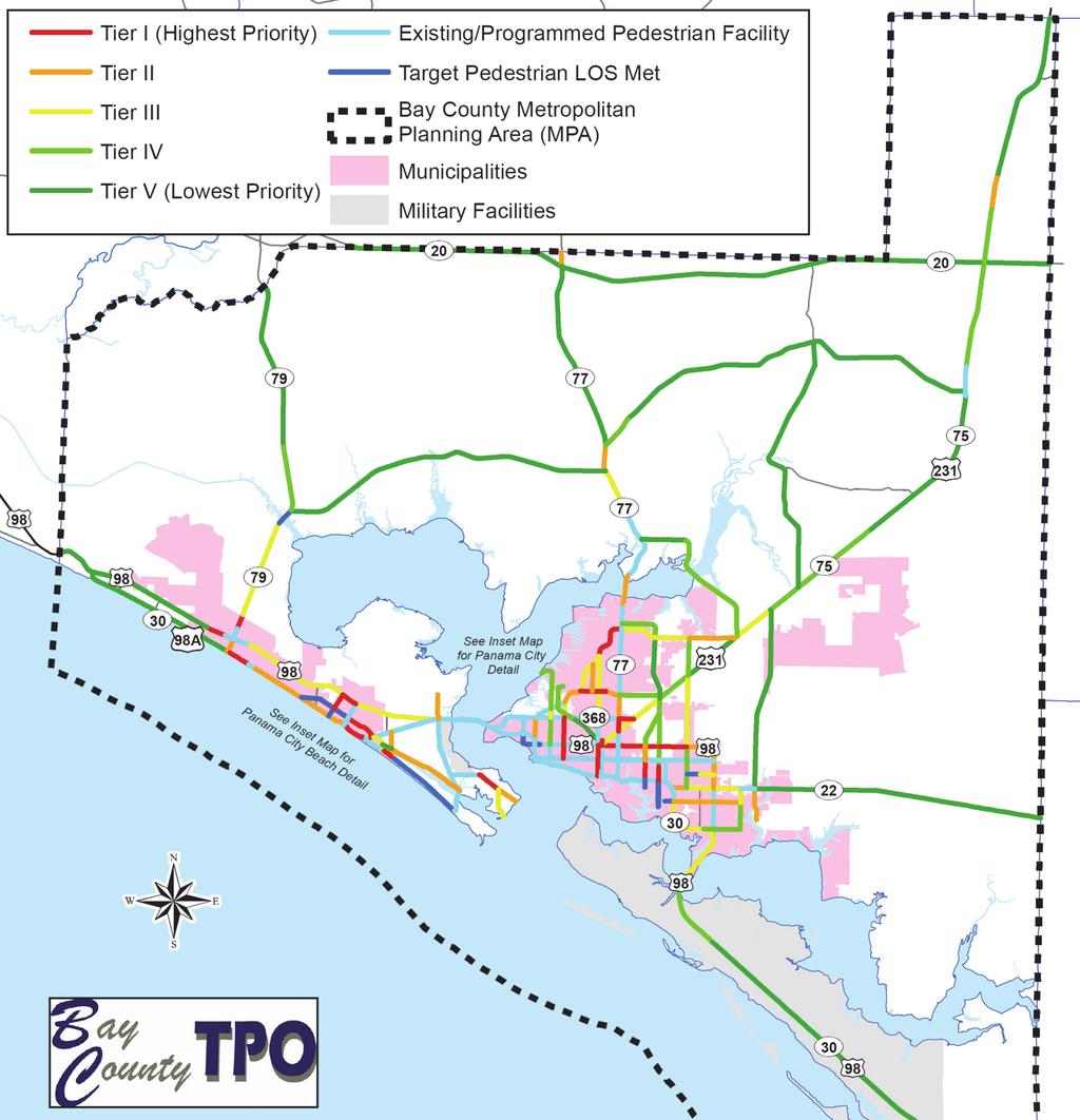
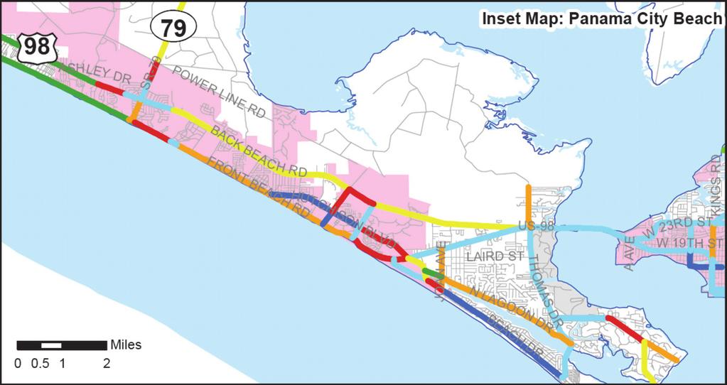
7 Pedestrian Priorities Map

8 Transit Needs & Cost Feasible Map
 Widen to 6 Lanes 19 US / Thomas Dr Interchange (Hathaway Bridge to Thomas Dr) Interchange Improvements 20 US (Hathaway Bridge) Widen / Restripe to 8 Lanes 21 US / 23rd St")
 Widen to 6 Lanes 25 US / Tyndall Pkwy (SR 22 to US BUS) Widen to 6 Lanes 26 US ALT (Deluna Pl to SR 79) CRA Improvements 27 US ALT / Front Beach Rd (SR 79 to Lullwater Dr) Add Trolley /")
 Add Trolley / Transit Lanes 30 US ALT / Front Beach Rd (S. Thomas Dr to N.")
 Widen to 6 Lanes 34 SR 20 (Washington County Line to US 231) Widen to 4 Lanes 35 SR 22 (US BUS to Transmitter Rd) Widen to 4 Lanes 36 SR 22 (Transmitter Rd to Tyndall Pkwy) Widen to 4 Lanes")
 Widen to 6 Lanes 42 SR (SR 390 to 4th St) Widen to 6 Lanes 43 SR 390 (SR 368 / 23rd St to Baldwin Rd) Widen to 6 Lanes 44 SR 390 (Baldwin Rd to Jenks Ave)")
 Widen to 4 Lanes 52 Alf Coleman Rd (SR 30 / US A / Front Beach Rd to US / Panama City Beach Pkwy) CRA Improvements 53 CR 392 / N.")
 Widen to 4 Lanes 55 Joan Ave (CR 392 / Thomas Dr to SR 30 / US A / Front Beach Rd) Widen to 4 Lanes 56 Moyland Rd (SR 30 / US A / Front Beach Rd to SR 30A / US / Panama City Beach Pkwy)")
9 JACKSON COUNTY Project List US (R. Jackson Blvd to Thomas Dr) Widen to 6 Lanes 19 US / Thomas Dr Interchange (Hathaway Bridge to Thomas Dr) Interchange Improvements 20 US (Hathaway Bridge) Widen / Restripe to 8 Lanes 21 US / 23rd St Interchange (Hathaway Bridge to 23rd St) Interchange Improvements 22 US (23rd St to Beck Ave) Widen to 6 Lanes 23 US (US 231 Interchange) Interchange Improvements 24 US / Tyndall Pkwy (Transmitter Rd to SR 22) Widen to 6 Lanes 25 US / Tyndall Pkwy (SR 22 to US BUS) Widen to 6 Lanes 26 US ALT (Deluna Pl to SR 79) CRA Improvements 27 US ALT / Front Beach Rd (SR 79 to Lullwater Dr) Add Trolley / Transit Lanes 28 US ALT / Front Beach Rd (Lullwater Dr to R. Jackson Blvd) Add Trolley / Transit Lanes 29 US ALT / Front Beach Rd (R. Jackson Blvd to S. Thomas Dr) Add Trolley / Transit Lanes 30 US ALT / Front Beach Rd (S. Thomas Dr to N. Thomas Dr) Add Trolley / Transit Lanes 31 US Bus (Cherry St to Tyndall Pkwy) Widen to 4 Lanes 32 US 231 (US 231 at CR 2321) Intersection Alignment 33 US 231 (SR 368 / 23rd St to Jonny Ln / Urban Boundary) Widen to 6 Lanes 34 SR 20 (Washington County Line to US 231) Widen to 4 Lanes 35 SR 22 (US BUS to Transmitter Rd) Widen to 4 Lanes 36 SR 22 (Transmitter Rd to Tyndall Pkwy) Widen to 4 Lanes 37 SR 22 (Tyndall Pkwy to Star Ave) Widen to 4 Lanes 38 SR 22 (Star Ave to Gulf Coast Pkwy) Widen to 4 Lanes 39 SR (SR at CR 388) Intersection Improvement 40 SR (US to SR 368 / 23rd St) Widen to 6 Lanes 41 SR (SR 368 / 23rd St to Baldwin Rd) Widen to 6 Lanes 42 SR (SR 390 to 4th St) Widen to 6 Lanes 43 SR 390 (SR 368 / 23rd St to Baldwin Rd) Widen to 6 Lanes 44 SR 390 (Baldwin Rd to Jenks Ave) Widen to 6 Lanes WALTON COUNTY CR Powell Adams Dr (US ALT / Front Beach Rd to US / Panama City Beach Pkwy) Widen to 4 Lanes 50 Hill Rd (US A / Front Beach Rd to US / Panama City Beach Pkwy) Widen to 4 Lanes 51 Clara Ave (US ALT / Front Beach Rd to US ) Widen to 4 Lanes 52 Alf Coleman Rd (SR 30 / US A / Front Beach Rd to US / Panama City Beach Pkwy) CRA Improvements 53 CR 392 / N. Thomas Dr (SR 30 / US A / Front Beach Rd to Joan Ave) Widen to 4 Lanes 54 S. Thomas Dr (SR 30 / US A / Front Beach Rd to N. Thomas Dr) Widen to 4 Lanes 55 Joan Ave (CR 392 / Thomas Dr to SR 30 / US A / Front Beach Rd) Widen to 4 Lanes 56 Moyland Rd (SR 30 / US A / Front Beach Rd to SR 30A / US / Panama City Beach Pkwy) Widen to 4 Lanes 57 Laird St (CR 3031 / Thomas Dr to Joan Ave) Widen to 4 Lanes 58 CR 3031 / Thomas Dr (N. Lagoon Dr to US Interchange) Widen to 6 Lanes 59 CR 28 / 11th St (Beck Ave to Lisenby Ave) Widen to 4 Lanes 60 CR 28 / 11th St (Lisenby Ave to SR 389 / East Ave) Widen to 4 Lanes 61 CR 28 / 11th St (SR 389 / East Ave to Transmitter Rd) Widen to 4 Lanes 62 SR 368 / 23rd St (US to SR 390 / Beck Ave) Widen to 6 Lanes 63 SR 368 / 23rd St Extension (US 231 to East Ave / SR 389) New 4 Lane 64 Baldwin Rd / CR 2312 (SR 390 to Minnesota Ave) Widen to 4 Lanes 65 Baldwin Rd / CR 2312 (Minnesota Ave to US 231) Widen to 4 Lanes 66 Baldwin Rd / CR 2312 Ext (US 231 to Transmitter Rd) New 4 Lane 67 26th St (Lynn Haven) (SR to Minnesota Ave) New 2 Lane 68 CR 389 / 12th St (SR to CR 390) Widen to 4 Lanes 69 CR 389 / 12th St (CR 390 to Baldwin Rd) Widen to 4 Lanes 70 Jenks Ave / CR 2341 (CR 368 / 23rd St to Baldwin Rd) Widen to 4 Lanes 71 Jenks Ave / CR 2341 (Baldwin Rd to SR 390) Widen to 4 Lanes 72 SR 389 / East Ave (CR 28 / 11th St to US / 15th St) Widen to 4 Lanes 73 SR 389 / East Ave (US / 15th St to Sherman Ave) Widen to 4 Lanes 74 SR 389 / East Ave (Sherman Ave to US 231 / SR 75) Widen to 4 Lanes 75 CR 389 / East Ave (US 231 / SR 75 to Baldwin Road) Widen to 4 Lanes 76 Transmitter Rd / CR 2327 (SR 22 to CR 390) Widen to 4 Lanes Tram Rd / CR 101 (US / Tyndall Pkwy to Gulf Coast Pkwy) New 2 Lane 78 7th St Realignment (US / Tyndall Pkwy to Star Ave / CR 2315) New 2 Lane 79 CR 2301 (US 231 to End of Urbanized Area) Widen to 4 Lanes 80 CR 388 (SR to US 231) Widen to 4 Lanes 81 US /SR30 (Tyndall Air Force Base Main Gate) New Overpass West Bay 30A FRO NT B PCB EAC HR D PKW Y 48 ALT LYNN HAVEN CR PANAMA CITY BEACH SR rd St 392 A 53 LAIRD ST CR TH OM AS 59 11TH ST St. Andrew Bay Mexico BALDWIN RD CR 28 CR PANAMA CITY DR 64 CR of Gulf 6 CR R. J SR 79 (US ALT / Front Beach Rd to US / Panama City Beach Pkwy) CRA Improvements CLA ALF CR 390 (CR 389 to US 231) Widen to 4 Lanes CHERRY ST 25 BUS 24 D MR TRA 7th ST CALLAWAY 22 East Bay Legend 81 * West Bay Connector Study Area / Representative Alignment * West Bay Parkway Study Area / Representative Alignment * Gulf Coast Parkway Study Area / Representative Alignment No. of Lanes = 2 No. of Lanes = 4 No. of Lanes = 6 No. of Lanes = 8 Transit / Trolley Lanes Fully Funded Improvement 30 Partially Funded Improvement Interchange Project 0 Map ID Number 0 Map ID Number (Project Not Funded) 16 (Project Fully Funded) 0 Map ID Number (Project Partially Funded) * Future Route to be determined through on-going PD&E Study. MEXICO BEACH CR R AS D THOM 031 CR 3 CR 390 (SR to CR 389) Widen to 4 Lanes CR SR 390 (Jenks Ave to SR ) Widen to 6 Lanes 46 COUNTY 80 POW 45 BAY CALHOUN COUNTY US (Mandy Ln to R. Jackson Blvd) Widen to 6 Lanes GULF COUNTY 17 CR 2301 Gulf to Bay Hwy / CR 386A (US, west of Mexico Beach to Bay / Gulf County Line) New 4 Lane STAR AVE STAR AVE Power Line Rd (SR 79 to Richard Jackson Blvd) New 4 Lane TYNDALL PKWY TRANSMITTER RD Power Line Rd (West Bay Pkwy to SR 79) New 4 Lane CR WASHINGTON COUNTY SR 389 West Bay Connector (West Bay Parkway / CR 388 to Washington County Line) New 4 Lane JENKS AVE 13 HARRISON AVE Gulf Coast Pkwy / CR 386 (Gulf County) (Gulf Coast Pkwy to US at Gulf County line) Widen to 4 Lanes SR Gulf Coast Parkway (SR 22 near Gulf County line to CR 386 near Overstreet (Gulf County) New 4 Lane BECK AVE 11 MOYLAN RD Gulf Coast Parkway / SR 22 (Gulf Coast Pkwy to Gulf County) Widen to 4 Lanes JOAN AVE 10 D Gulf Coast Parkway (Star Ave near Tram Rd to SR 22) New 4 Lane 79 D 9 20 BLV Gulf Coast Pkwy / Star Ave (US 231 to Tram Rd) Widen to 4 Lanes NR 8 EMA Gulf Coast Pkwy Ext (CR 2321 North of CR 2293 to US 231) New 4 Lane SON 7 ACK Gulf Coast Pkwy Ext / CR 2321 (Gulf Coast Pkwy Ext at Hodges Bayou to north of CR 2293) Widen to 4 Lanes AVE 6 RA Gulf Coast Pkwy Ext (SR near Grassy Point Rd to CR 2321) New 4 Lane COL 5 DR West Bay Parkway (CR 388 west of SR ) New 4 Lane L RD 4 Interstate Connector from Panama City to Alabama State Line Corridor To Be Determined 81 MS West Bay Pkwy / CR 388 (West Bay Parkway east of SR 79 to West Bay Pkwy west of SR ) Widen to 4 Lanes HILL 3 DR West Bay Parkway (SR 79 to CR 388 east of SR 79) New 4 Lane ADA 2 ELL West Bay Parkway (Walton County line to SR 79) New 4 Lane LWA TER 1 83 LUL Improvement Map ID CR 386
Needs Plan Report BAY COUNTY 2040 LONG RANGE TRANSPORTATION PLAN
 Needs Plan Report BAY COUNTY 2040 LONG RANGE TRANSPORTATION PLAN Prepared for Bay County Transportation Planning Organization and The Florida Department of Transportation, District Three Prepared by West
Cost Feasible Plan Report BAY COUNTY 2040 LONG RANGE TRANSPORTATION PLAN
 Cost Feasible Plan Report BAY COUNTY 2040 LONG RANGE TRANSPORTATION PLAN Prepared for Bay County Transportation Planning Organization and The Florida Department of Transportation, District Three Prepared
2. TRANSPORTATION ELEMENT.
 2. TRANSPORTATION ELEMENT. The purpose of this element is to assist in establishing an adequate transportation system within the City and to plan for future motorized and non-motorized traffic circulation
GOAL 2A: ESTABLISH AND MAINTAIN A SAFE, CONVENIENT, AND EFFICIENT MULTI-MODAL TRANSPORTATION SYSTEM TO MOVE PEOPLE AND GOODS THROUGHOUT THE CITY.
 2. TRANSPORTATION ELEMENT The purpose of this element is to assist in establishing an adequate transportation system within the City and to plan for future motorized and non-motorized traffic circulation
BAY COUNTY BICYCLE/PEDESTRIAN PLAN AMENDMENT REPORT
 BAY COUNTY BICYCLE/PEDESTRIAN PLAN AMENDMENT REPORT Prepared for Bay County Transportation Planning Organization and The Florida Department of Transportation, District Three Prepared by West Florida Regional
CITY OF COCOA BEACH 2025 COMPREHENSIVE PLAN. Section VIII Mobility Element Goals, Objectives, and Policies
 CITY OF COCOA BEACH 2025 COMPREHENSIVE PLAN Section VIII Mobility Element Goals, Objectives, and Policies Adopted August 6, 2015 by Ordinance No. 1591 VIII MOBILITY ELEMENT Table of Contents Page Number
Transportation Master Plan Advisory Task Force
 Transportation Master Plan Advisory Task Force Network Alternatives & Phasing Strategy February 2016 BACKGROUND Table of Contents BACKGROUND Purpose & Introduction 2 Linking the TMP to Key Council Approved
FY FY 2023 Bay County TPO Project Priorities
 FY 2019 - FY 2023 Bay County TPO Project Priorities Prepared for Bay County Transportation Planning Organization; and The Florida Department of Transportation, District Three Prepared by West Florida Regional
Welcome. Background. Goals. Vision
 Welcome The formal Public Information Centre (PIC) for the Transportation Master Plan How We GO will be held in early 2017. At that time we will present the recommended transportation system for Niagara
Basalt Creek Transportation Refinement Plan Recommendations
 Basalt Creek Transportation Refinement Plan Recommendations Introduction The Basalt Creek transportation planning effort analyzed future transportation conditions and evaluated alternative strategies for
Tulsa Metropolitan Area LONG RANGE TRANSPORTATION PLAN
 Tulsa Metropolitan Area LONG RANGE TRANSPORTATION PLAN Indian Nations Council of Governments August 2005 CONTACTING INCOG In developing the Destination 2030 Long Range Transportation Plan, INCOG s Transportation
Exhibit 1 PLANNING COMMISSION AGENDA ITEM
 Exhibit 1 PLANNING COMMISSION AGENDA ITEM Project Name: Grand Junction Circulation Plan Grand Junction Complete Streets Policy Applicant: City of Grand Junction Representative: David Thornton Address:
Goal 3: Foster an environment of partnerships and collaboration to connect our communities and regions to one another.
 Non-Motorized Transportation Plan (NMTP) Draft Vision, Goal and,, Tri-County Regional Planning Commission (TCRPC) Purpose The purpose of the Tri-County Regional Planning Commission (TCRPC) Non-Motorized
SR 9/I-95 Interchange at 45 th Street PD&E Study Palm Beach County, Florida FPID No.: FAP No.: ETDM No.
 SR 9/I-95 Interchange at PD&E Study Palm Beach County, Florida FPID No.: 436519-1-22-01 FAP No.: 0951-682-1 ETDM No.: 14225 Palm Beach County MPO October 19, 2017 SR 9/I-95 Interchange at PD&E Study Presentation
APPENDIX G: INTERSECTION NEEDS AT OKEECHOBEE BOULEVARD
 APPENDIX G: INTERSECTION NEEDS AT OKEECHOBEE BOULEVARD INTERSECTION NEEDS AT SR 7 and OKEECHOBEE BOULEVARD SR 7 Extension Project Development and Environment (PD&E) Study From Okeechobee Boulevard (SR
Bicycle Master Plan Goals, Strategies, and Policies
 Bicycle Master Plan Goals, Strategies, and Policies Mobilizing 5 This chapter outlines the overarching goals, action statements, and action items Long Beach will take in order to achieve its vision of
Title. Metropolitan Council Transportation Committee December 12, Brad Larson Metro District MnDOT
 Title Metropolitan Council Transportation Committee December 12, 2016 Evaluating the potential for Bus Rapid Transit and MnPASS Express Lanes in the southwest Metro Brad Larson Metro District MnDOT Background
RESOLUTION NO ?? A RESOLUTION OF THE CITY OF NEPTUNE BEACH ADOPTING A COMPLETE STREETS POLICY
 RESOLUTION NO. 2018-?? A RESOLUTION OF THE CITY OF NEPTUNE BEACH ADOPTING A COMPLETE STREETS POLICY WHEREAS, safe, convenient, and accessible transportation for all users is a priority of the City of Neptune
Performance Criteria for 2035 Long Range Transportation Plan
 Minimizing Impacts on Natural, Historic, Cultural or Archeological Resources 2035 LRTP Weighting Factor: 7% Objective 1.1: Use appropriate planning and design criteria to protect and enhance the built
WEST AND SOUTH WEST RING ROAD DOWNSTREAM TRAFFIC IMPACTS
 Page 1 of 9 EXECUTIVE SUMMARY Alberta Transportation ( AT ) is preparing to construct the final sections of the Calgary Ring Road. This includes the South West Ring Road ( SWRR ) (from Lott Creek Blvd
SECTION 4 TRANSPORTATION
 SECTION 4 TRANSPORTATION 1. PURPOSE The purpose of the Transportation element is to evaluate the existing conditions of traffic circulation within the City of Panama City Beach in relation to the existing
Complete Streets Workshop Follow-up. April 27, 2011 Rockledge City Hall
 Complete Streets Workshop Follow-up April 27, 2011 Rockledge City Hall Agenda Complete Streets draft briefing presentation and sample policy language Share your Complete Streets projects and post workshop
5. Pedestrian System. Accomplishments Over the Past Five Years
 5. Pedestrian System Accomplishments Over the Past Five Years The Alamo Area Metropolitan Planning Organization (MPO) and its partner agencies recognize the importance of improving pedestrian mobility.
City of Novi Non-Motorized Master Plan 2011 Executive Summary
 City of Novi Non-Motorized Master Plan 2011 Executive Summary Prepared by: February 28, 2011 Why Plan? Encouraging healthy, active lifestyles through pathway and sidewalk connectivity has been a focus
Moving Cambridge. City of Cambridge Transportation Master Plan Public Consultation Centre. March 7, :00 8:00 PM.
 City of Cambridge Transportation Master Plan Public Consultation Centre March 7, 2018 5:00 8:00 PM Region of Waterloo City of Cambridge Transportation Master Plan Public Consultation Centre March 7, 2018
Mobility Greater Johnson County Transportation Coalition. May 23, 2018
 Mobility 2045 Greater Johnson County Transportation Coalition May 23, 2018 Agenda Regional Perspective Mobility Planning Overview Mobility 2045 Draft Recommendations Financial Planning Overview Schedule
Congress Avenue. Palm Beach MPO Subcommittee Meetings December 2017
 1 Congress Avenue Palm Beach MPO Subcommittee Meetings December 2017 2 Agenda Study Purpose Study Process Multimodal Alternatives Development Next Steps *ACTION ITEM: CONFIRM ALTERNATIVES TO MOVE INTO
WALKNBIKE DRAFT PLAN NASHVILLE, TENNESSEE EXECUTIVE SUMMARY NASHVILLE, TENNESSEE
 NASHVILLE, TENNESSEE EXECUTIVE SUMMARY Executive Summary A world-class multi-modal transportation system is essential to a vibrant city and better quality of life. -Mayor Barry The WalknBike plan aims
4. ENVIRONMENTAL IMPACT ANALYSIS 9. TRANSPORTATION AND TRAFFIC
 4. ENVIRONMENTAL IMPACT ANALYSIS 9. TRANSPORTATION AND TRAFFIC 4.9.1 INTRODUCTION The following section addresses the Proposed Project s impact on transportation and traffic based on the Traffic Study
North Coast Corridor:
 North Coast Corridor: Connecting People, Transportation & Environment Legislative Hearing: 11.8.10 1 North Coast Corridor Region s Lifeline A Regional Strategy Mobility, Economy & Environment North Coast
Highway 217 Corridor Study. Phase I Overview Report
 Highway 217 Corridor Study Phase I Overview Report November 3, 24 BACKGROUND AND OVERVIEW Study purpose The Highway 217 Corridor Study is developing multi-modal transportation solutions for traffic problems
BIKE PLAN CONTENTS GATEWAY
 CONTENTS Acknowledgments...vii Great Rivers Greenway District Board of Directors... vii Great Rivers Greenway District Staff... vii Project Consultants... vii Committees... viii Citizens Advisory Committee
2045 Long Range Transportation Plan. Summary of Draft
 2045 Long Range Transportation Plan Summary of Draft Fredericksburg Area Metropolitan Planning Organization The George Washington Region includes the City of Fredericksburg and the counties of Caroline,
Corpus Christi Metropolitan Transportation Plan Fiscal Year Introduction:
 Introduction: The Safe, Accountable, Flexible, Efficient Transportation Equity Act: A Legacy for Users (SAFETEA-LU) has continued the efforts started through the Intermodal Surface Transportation Efficiency
DRAFT FY 2017-FY 2021 FLORIDA-ALABAMA NON-SIS PROJECT PRIORITIES PROPOSED CHANGES BY ESCAMBIA AND SANTA ROSA COUNTIES
 DRAFT FY 2017-FY 2021 FLORIDA-ALABAMA NON-SIS PROJECT PRIORITIES PROPOSED CHANGES BY ESCAMBIA AND SANTA ROSA COUNTIES Table 2: Non-Strategic Intermodal System (Non-SIS) Project Priorities FDOT Item- Phases
STUDY ADVISORY COMMITTEE. October 8, 2015
 STUDY ADVISORY COMMITTEE October 8, 2015 Study Purpose evaluate the long-term transportation strategies and investments needed to sustain the county s economic health and quality of life in the coming
Alternatives Public Workshop
 US 1 Express Lanes Project Development & Environment (PD&E) Study Alternatives Public Workshop August 2013 1 Today s Agenda Project Background and Overview Tier 1 Alternatives Development Tier 2 Decision-Making
City of Jacksonville Mobility Fee Update
 City of Jacksonville Mobility Fee Update 2017 Preliminary Analysis May 3, 2017 Carnival Cruise lines photo credit Presentation Overview Public Outreach Process Pedestrian and Bicycle Master Plan Study
City of Hamilton s Transportation Master Plan (TMP) Public Consultation 3 December 2015
 Public Consultation 3 December 2015") City of Hamilton s Transportation Master Plan (TMP) Public Consultation 3 December 2015 McPhail Transportation Planning Services Ltd. AGENDA 6:00 7:00 pm Viewing Boards / Q & A with the Team 7:00 7:50
City of Hamilton s Transportation Master Plan (TMP) Public Consultation 3 December 2015 McPhail Transportation Planning Services Ltd. AGENDA 6:00 7:00 pm Viewing Boards / Q & A with the Team 7:00 7:50
Chapter 7. Transportation. Transportation Road Network Plan Transit Cyclists Pedestrians Multi-Use and Equestrian Trails
 Chapter 7 Transportation Transportation Road Network Plan Transit Cyclists Pedestrians Multi-Use and Equestrian Trails 7.1 TRANSPORTATION BACKGROUND The District of Maple Ridge faces a number of unique
Welcome. Public Meeting. Heading 1. Heading 2. DeMers Ave. Columbia Rd. Washington St. 42nd St. 32nd Ave. Heading 3 HEADING
 Heading 1 Heading 2 Heading 3 HADING Welcome 4 Heading 5 Normal Normal Less Spacing Public Meeting Normal No Spacing Strong mphasis Intense mphasis To Do List ullet List ullet Last List ullet 2 CÞ List
Owl Canyon Corridor Project Overview and Summary
 Owl Canyon Corridor Project Overview and Summary December 22, 2008 The Owl Canyon corridor (generally the connection between the I-25 / Larimer County Road 70 interchange and the US 287 / Larimer County
Draft MOBILITY ELEMENET. Community Meeting May 22, 2013
 Draft MOBILITY ELEMENET Community Meeting May 22, 2013 Agenda Presentation Ira Brown New Mobility Paradigm Movement of People Implementation Q&A Ira Brown and Dave Roseman Small Group Discussion at Each
DES MOINES AREA MPO. Presentation to Iowa Commercial Real Estate Association. April 6, 2017
 DES MOINES AREA MPO Presentation to Iowa Commercial Real Estate Association April 6, 2017 Presentation Outline MPO Overview Trends We re Watching Plans, Projects, Initiatives, Regional Transportation Priorities
City of Bartow Comprehensive Plan. Transportation Element
 City of Bartow 2030 Comprehensive Plan Amended through January 7, 2013 TRANSPORTATION ELEMENT GOAL: IT SHALL BE A GOAL OF THE CITY OF BARTOW TO PROVIDE A SAFE AND EFFICIENT MULTI-MODAL TRANSPORTATION SYSTEM
INTRODUCTION. Specifically, the objectives are to:
 INTRODUCTION The River to Sea Transportation Planning Organization (TPO) conducts the Tell the TPO Transportation Trends Survey to better understand the transportation preferences and priorities for the
MnDOT Implementation of Complete Streets Policy. January 2014
 MnDOT Implementation of Complete Streets Policy January 2014 1 Prepared by Minnesota Department of Transportation 395 John Ireland Boulevard Saint Paul, Minnesota 55155-1899 Phone: 651-296-3000 Toll-Free:
ALTERNATIVES ANALYSIS EXECUTIVE SUMMARY
 West Valley Connector Corridor ALTERNATIVES ANALYSIS EXECUTIVE SUMMARY FINAL September 2014 Ontario International Airport Ontario Mills Rancho Cucamonga Metrolink Station Kaiser Permanente PARSONS EXECUTIVE
Chapter 5. Complete Streets and Walkable Communities.
 Chapter 5. Complete Streets and Walkable Communities. 5.1 Description of Complete Streets. Cities throughout the world, and specifically the United States, are coming to embrace a new transportation and
APPENDIX D: Southwest Volusia Regional Transportation Study. Evaluation Criteria FINAL
 D: PROJECT PRIORITIZATION Prioritization of the improvements proposed in the Multimodal Improvement Plan is required in order to determine which projects should be funded first, where the transportation
Prioritizing Transportation Policy and Funding for Active Transportation, Safety, Equity and Health
 Mayor Karl Dean, Chairman Prioritizing Transportation Policy and Funding for Active Transportation, Safety, Equity and Health Leslie A. Meehan, AICP Planning and Implementing the Active Community Webinar
Regional Transportation Needs Within Southeastern Wisconsin
 Regional Transportation Needs Within Southeastern Wisconsin #118274 May 24, 2006 1 Introduction The Southeastern Wisconsin Regional Planning Commission (SEWRPC) is the official areawide planning agency
CITY OF BLOOMINGTON COMPLETE STREETS POLICY
 CITY OF BLOOMINGTON COMPLETE STREETS POLICY POLICY OBJECTIVE: The City of Bloomington will enhance safety, mobility, accessibility and convenience for transportation network users of all ages and abilities,
CITY OF VAUGHAN EXTRACT FROM COUNCIL MEETING MINUTES OF OCTOBER 30, 2012
 CITY OF VAUGHAN EXTRACT FROM COUNCIL MEETING MINUTES OF OCTOBER 30, 2012 Item 31, Report No. 39, of the Committee of the Whole, which was adopted without amendment by the Council of the City of Vaughan
INNER LOOP EAST. AIA Rochester Annual Meeting November 13, 2013 TRANSFORMATION PROJECT. Bret Garwood, NBD Erik Frisch, DES
 INNER LOOP EAST TRANSFORMATION PROJECT AIA Rochester Annual Meeting November 13, 2013 Bret Garwood, NBD Erik Frisch, DES Why? We are building a city that encourages walking, biking and enjoying the outdoor
SR 693 (Pasadena Avenue) Corridor Study from Shore Drive South to 66 th Street
 Corridor Study from Shore Drive South to 66 th Street") Welcome and Introduction Sign-in and comment sheets Restrooms and exits Meeting agenda and timeline Meeting goals / expectations Provide input to guide study recommendations Actively participate throughout
Welcome and Introduction Sign-in and comment sheets Restrooms and exits Meeting agenda and timeline Meeting goals / expectations Provide input to guide study recommendations Actively participate throughout
Chapter 2. Bellingham Bicycle Master Plan Chapter 2: Policies and Actions
 Chapter 2 Bellingham Bicycle Master Plan Chapter 2: Policies and Actions Chapter 2: Policies and Actions The Bicycle Master Plan provides a road map for making bicycling in Bellingham a viable transportation
Scope of Services BICYCLE/PEDESTRIAN PLAN FOR THE INDIAN RIVER COUNTY MPO
 I. INTRODUCTION Scope of Services BICYCLE/PEDESTRIAN PLAN FOR THE INDIAN RIVER COUNTY MPO The Indian River County Metropolitan Planning Organization (MPO) Bicycle and Pedestrian Plan was completed in 1997.
South King County High-Capacity Transit Corridor Study
 HIGH-CAPACITY TRANSIT CORRIDOR STUDY South King County Corridor South King County High-Capacity Transit Corridor Study Corridor Report August 2014 South King County High Capacity Transit Corridor Report
Solana Beach Comprehensive Active Transportation Strategy (CATS)
") Solana Beach Comprehensive Active Transportation Strategy (CATS) 3.0 Goals & Policies The Solana Beach CATS goals and objectives outlined below were largely drawn from the Solana Beach Circulation Element
Solana Beach Comprehensive Active Transportation Strategy (CATS) 3.0 Goals & Policies The Solana Beach CATS goals and objectives outlined below were largely drawn from the Solana Beach Circulation Element
Ann Arbor Downtown Street Plan
 1 Ann Arbor Downtown Street Plan Public Workshop #1 We know that. 2 Public right-of-way (streets, sidewalks, and alleys) make up 30% of the total District area of downtown. Streets need to provide mobility
I-20 ODESSA-MIDLAND CORRIDOR STUDY. Public Meeting for Schematic Design
 I-20 ODESSA-MIDLAND CORRIDOR STUDY Public Meeting for Schematic Design The environmental review, consultation, and other actions required by applicable Federal environmental laws for this project are being,
Florida Department of Transportation District Four. I-95 at 6 th Avenue Interchange Improvements FDOT PM - Fernando Morales, PE
 1 Florida Department of Transportation District Four I-95 at 6 th Avenue Interchange Improvements FDOT PM - Fernando Morales, PE Presentation Outline Overview of Planning and Programming I-95 Interchange
Providing an Efficient and Multi-modal Transportation System
 Providing an Efficient and Multi-modal Transportation System Welcome and Introductions The Plan Process Transportation Overview Workshop Discussions Report Out and Next Steps AGENDA Comprehensive Plan
AMATS Complete Streets Policy
 AMATS Complete Streets Policy Table of Contents: Section 1. Definition of Complete Streets Section 2. Principles of Complete Streets Section 3. Complete Streets Policy Section 4. Consistency Section 5.
HIGHWAY 11 CORRIDOR STUDY
 HIGHWAY 11 CORRIDOR STUDY Executive Summary August 2016 Roseau County?æA@?çA@ Warroad Lake of the Woods Roseau Roosevelt Badger?ÄA@ Greenbush Legend N Hwy 11 Study Area Figure 1: Corridor Study Limits
Portland International Airport Bicycle and Pedestrian Plan (October 2003) Staff Acknowledgements
 Staff Acknowledgements") Portland International Airport Bicycle and Pedestrian Plan (October 2003) Staff Acknowledgements Scott King, Senior Aviation Planner Jason Gately, Senior Aviation Planner Preston Beck, Associate Planner
Portland International Airport Bicycle and Pedestrian Plan (October 2003) Staff Acknowledgements Scott King, Senior Aviation Planner Jason Gately, Senior Aviation Planner Preston Beck, Associate Planner
Downtown Naples Mobility and Connectivity Study. Naples City Council Presentation January 2017
 Downtown Naples Mobility and Connectivity Study Naples City Council Presentation January 2017 Agenda 1. Introduction 2. Scope Review 3. Project Schedule 4. Existing Conditions 5. Public Charrette 6. Mobility
5.0 Roadway System Plan
 Southwest Boise Transportation Study Page 16 5.0 Roadway System Plan The Roadway System Plan outlines roadway improvements in the Initial Study Area. It forecasts future deficiencies on the arterial system,
CHARLOTTE COUNTY PUNTA GORDA MPO
 CHARLOTTE COUNTY PUNTA GORDA MPO 2035 Long Range Transportation Plan Summary Report (For Adoption by Charlotte County Punta Gorda MPO Board on December 13, 2010) Table of Contents Table of Contents Introduction
Appendix C 3. Bicycle / Pedestrian Planning
 Appendix C 3. Bicycle / Pedestrian Planning BICYCLE/PEDESTRIAN PLANNING 2005 Master Plan GOAL: Provide for safe and convenient bicycle and pedestrian circulation throughout the City. Develop a city-wide
NEED FOR ADDITIONAL FUNDING
 Measure B BACKGROUND 2013: Vision for a supplement to Measure A that prioritizes local roads & regional capital projects Plan developed by Professional Advisory Group Consensus recently built on RT O&M
Kelowna On the Move. Pedestrian and Bicycle Master Plan
 Kelowna On the Move Pedestrian and Bicycle Master Plan Executive Summary April 2016 Purpose of the Plan The Pedestrian and Bicycle Master Plan identifies infrastructure, planning, and policy requirements
ACTION TRANSMITTAL No
 Transportation Advisory Board of the Metropolitan Council of the Twin Cities ACTION TRANSMITTAL No. 2016-15 DATE: January 14, 2016 TO: TAC Planning Committee PREPARED BY: Steven Elmer (651) 602-1756 SUBJECT:
Bike/Multipurpose Trail Study for Glynn County, Georgia MAY 16, 2016
 Bike/Multipurpose Trail Study for Glynn County, Georgia MAY 16, 2016 Agenda» Project Status Update» Draft Recommendations Overview» Next Steps» Questions/Discussion Project Overview» Comprehensive Bikeway
Chapter 5 Future Transportation
 Chapter 5 Future Transportation The Future Land Use Plan identifies the desired land use designations. The land uses desired for Crozet depend, in large part, on the success of the transportation system,
REGIONAL PRIORITIES Presentation to the Tampa Bay Regional Collaboration Committee September 10, 2012
 WEST CENTRAL FLORIDA MPO CHAIRS COORDINATING COMMITTEE REGIONAL PRIORITIES Presentation to the Tampa Bay Regional Collaboration Committee September 10, 2012 TRANSPORTATION REGIONAL INCENTIVE PROGRAM (TRIP)
Project Development & Environment (PD&E) Study Public Hearing January 12 th, 2006
 Study Public Hearing January 12 th, 2006") Project Development & Environment (PD&E) Study Public Hearing January 12 th, 2006 Public Hearing Regulations Chapter 23 of United States Code 128 Title 40 of the Code of Federal Regulations Parts 1500
Project Development & Environment (PD&E) Study Public Hearing January 12 th, 2006 Public Hearing Regulations Chapter 23 of United States Code 128 Title 40 of the Code of Federal Regulations Parts 1500
University of Victoria Campus Cycling Plan Terms of Reference. 1.0 Project Description
 University of Victoria Campus Cycling Plan Terms of Reference 1.0 Project Description The Campus Cycling Plan, a first for the University, will provide a comprehensive and coordinated approach to support
Orange County s Transportation Planning and Multimodal Corridor Plan
 Orange County Transportation Planning Division Orange County s Transportation Planning and Multimodal Corridor Plan Presentation to UCF LIFE November 11, 2014 Alissa Barber Torres, Ph.D., AICP, PLS Presentation
Route 7 Corridor Study
 Route 7 Corridor Study Executive Summary Study Area The following report analyzes a segment of the Virginia State Route 7 corridor. The corridor study area, spanning over 5 miles in length, is a multi
City of Charlottesville Bicycle and Pedestrian Master Plan Update
 City of Charlottesville Bicycle and Pedestrian Master Plan Update September 17, 2014 I. Welcome and meeting overview II. Project status update III. Network overview IV. Break-out groups Pedestrian Network
WELCOME TO OPEN HOUSE # 1 June 14, 2017
 Langstaff Road Weston Road to Highway 7 Class Environmental Assessment Study WELCOME TO OPEN HOUSE # 1 June 14, 2017 Please sign in and join our mailing list Purpose of Open House #1 & Study Area York
Circulation in Elk Grove includes: Motor vehicles, including cars and trucks
 Circulation, as it is used in this General Plan, refers to the many ways people and goods move from place to place in Elk Grove and the region. Circulation in Elk Grove includes: Motor vehicles, including
Proposed. City of Grand Junction Complete Streets Policy. Exhibit 10
 Proposed City of Grand Junction Complete Streets Policy Exhibit 10 1 City of Grand Junction Complete Streets Policy Vision: The Complete Streets Vision is to develop a safe, efficient, and reliable travel
Clackamas County Comprehensive Plan
 ROADWAYS The County s road system permits the movement of goods and people between communities and regions, using any of a variety of modes of travel. Roads provide access to virtually all property. They
Bicycle and Pedestrian Chapter TPP Update Overview. TAB September 20, 2017
 Bicycle and Pedestrian Chapter TPP Update Overview TAB September 20, 2017 Bicycling & Walking in the Twin Cities Where are we now? The Bike-Pedestrian system Current trends New developments Where are we
SAN FRANCISCO MUNICIPAL TRANSPORTATION AGENCY
 THIS PRINT COVERS CALENDAR ITEM NO. : 11 DIVISION: Sustainable Streets BRIEF DESCRIPTION: SAN FRANCISCO MUNICIPAL TRANSPORTATION AGENCY Approving traffic modifications on Twin Peaks Boulevard between Christmas
Washington DC Section of ITE Project Briefing
 Washington DC Section of ITE Project Briefing November 5, 2015 Renée Hamilton, VDOT, Deputy District Administrator I-66 Outside the Beltway Improvement Area Project Location Virginia 2 Purpose and Need
Rhode Island Moving Forward Long-Range Transportation Plan 2040 Municipal Roundtable Newport County
 Rhode Island Moving Forward Long-Range Transportation Plan 2040 Municipal Roundtable Newport County www.planri.com PlanRI2040@gmail.com Municipal Roundtable Meeting Summary Date/time: Location: Wednesday,
Vision to Action Community Coalition February 14, 2014 Briefing
 Vision to Action Community Coalition February 14, 2014 Briefing Transportation and Transit Planning & Mass Transit Operations Strategic Growth Area Office Brian S. Solis Transportation & Transit Manager
ROUTES 55 / 42 / 676 BUS RAPID TRANSIT LOCALLY PREFERRED ALTERNATIVE
 ROUTES 55 / 42 / 676 BUS RAPID TRANSIT LOCALLY PREFERRED ALTERNATIVE April, 2012 1 INTRODUCTION The need for transit service improvements in the Routes 42/55/676 corridor was identified during the Southern
TRASBURG RANSPORTATION
 TRASBURG RANSPORTATION LAN DEVELOPED BY THE TRANSPORTATION PLANNING DIVISION OF THE VIRGINIA DEPARTMENT OF TRANSPORTATION IN COOPERATION WITH THE U.S. DEPARTMENT OF TRANSPORTATION, FEDERAL HIGHWAY ADMINISTRATION
Arterial Transitway Corridors Study. Ave
 Arterial Transitway Corridors Study Ave January 2012 Arterial Transitway Corridors Study Overview Corridor Features and Demographics 11 study corridors, 95 route miles 86,000 daily rides and half of existing
Bicycle and Pedestrian Plans and Improvements
 Bicycle and Pedestrian Plans and Improvements Presented to the City Council By Randle Harwood, Planning and Development, and Richard Zavala, Parks and Community Services September 24, 2013 Purpose Review
DRAFT BUENA VISTA 2020 TRANSPORTATION PLAN
 DRAFT BUENA VISTA 2020 TRANSPORTATION PLAN DEVELOPED BY THE TRANSPORTATION PLANNING DIVISION OF THE VIRGINIA DEPARTMENT OF TRANSPORTATION IN COOPERATION WITH THE U.S. DEPARTMENT OF TRANSPORTATION, FEDERAL
Welcome to Laredo Metropolitan Transportation Plan First Public Meeting. February 27 th, :30 PM to 7:30 PM. We value your opinion!
 Welcome to Laredo 2015-2040 Metropolitan Transportation Plan First Public Meeting February 27 th, 2014-5:30 PM to 7:30 PM We value your opinion! Todays Objectives Initiate the planning exercise for the
Town of Bethlehem. Planning Assessment. Bethlehem Town Board
 Town of Bethlehem US 9W Corridor Transportation Planning Assessment Presented e to: Bethlehem Town Board June 2009 Overview Study Background Route 9W Corridor Conditions and Improvements Selkirk Bypass
Florida Department of Transportation
 RICK SCOT l GOVERNOR ~ ~~ Florida Department of Transportation 3400 West Commercial Boulevard Fort Lauderdale, Florida 33309-3421 ANANTH PRASAD, P.E. SECRETARY Mr. Joseph Baird County Administrator 1801
FLORIDA DEPARTMENT OF TRANSPORTATION DISTRICT 7 DISTRICT WIDE BICYCLE/PEDESTRIAN ACCESS TO TRANSIT SAFETY ASSESSMENT AND IMPROVEMENT PLAN
 FLORIDA DEPARTMENT OF TRANSPORTATION DISTRICT 7 DISTRICT WIDE BICYCLE/PEDESTRIAN ACCESS TO TRANSIT SAFETY ASSESSMENT AND IMPROVEMENT PLAN TRANSIT SAFETY ASSESSMENT SR 55/US 19 AT 80 TH AVE N DRAFT JUNE