Section 5.4 Traffic and Circulation
|
|
|
- John Small
- 5 years ago
- Views:
Transcription
1 Section 5.4 Traffic and Circulation
2 SECTION 5.4 TRAFFIC AND CIRCULATION This section addresses the impacts of future traffic growth, planned physical improvements, and additional improvements to accommodate growth within the City of Buena Park. This section is based upon the City of Buena Park Circulation Existing Conditions (October 2009) and Circulation Forecast Conditions Analysis (August 2010) prepared by Kimley-Horn Associates, Inc.; refer to Appendix C EXISTING SETTING EXISTING CIRCULATION SYSTEM Regional Access The City of Buena Park is located in northwestern portion of Orange County and is bordered on the east by the City of Fullerton, on the south by the Cities of Anaheim and Cypress, and on the northwest by the City of La Mirada. Many of the arterial roadways trending through the City extend beyond the City boundaries into neighboring cities. Therefore, circulation issues and travel patterns extend beyond the City limits. Land use decisions and traffic patterns in adjacent jurisdictions have the potential to affect traffic flow and mobility in the City of Buena Park, and conversely, traffic conditions and decisions made by the City of Buena Park can affect other jurisdictions. The Santa Ana Freeway (I-5) provides north-south regional circulation, extending from Los Angeles County, through Orange County, and into San Diego County. It is currently an eight- to ten-lane freeway, with High Occupancy Vehicle (HOV) lanes in both directions. The Artesia Freeway (SR-91) provides for east-west regional access from Los Angeles County, through Orange County, and into Riverside County. It is currently a 10-lane freeway with HOV lanes in both directions. Both the I-5 and SR-91 freeways cut through the center of the city. The I-5/SR-91 interchange is located to the east of the City boundary, just south of Orangethorpe Avenue. Beach Boulevard (SR-39) is a state highway that originates at Pacific Coast Highway (PCH) in the City of Huntington Beach, and extends north through the Cities of Westminster, Garden Grove, Anaheim, and Buena Park, terminating at Whittier Boulevard in the City of La Habra. Beach Boulevard has full interchanges with Interstate 405 (I-405), State Route 22 (SR-22), State Route (SR-91), and Interstate 5 (I-5). Beach Boulevard generally consists of three to four through lanes in each direction through the City of Buena Park, and is generally separated by a raised, landscaped median. Draft EIR Page Buena Park General Plan Update September 2010
3 Functional Street Classifications BUENA PARK ROADWAY CLASSIFICATIONS The City s roadway network serves two distinct functions: it provides access to adjacent land uses, and it facilitates the movement of persons and goods to, from, within, and through the City. These functions assist in determining the design and operation of each street. Streets that serve the purpose of mobility and/or regional access will have more lanes, higher speed limits, and fewer driveways. Where direct access to properties is provided, streets will have fewer lanes, lower speeds, on-street parking, and more frequent driveways. To define the intended uses of roadways, many jurisdictions, including the City of Buena Park, use a functional classification system. The system provides a logical framework for the design and operation of the roadway system and assists residents and decision makers to identify preferred characteristics of each street; refer to Exhibit 5.4-1, Existing Circulation Plan. The following roadway classifications have been identified: Principal Arterial Highway. A principal arterial primarily serves as a regional transportation facility, and consists of an eight-lane divided roadway. The typical rightof-way width is 144 feet and roadway width is 114 feet, curb-to-curb, including a 14-foot median. Principal arterials in the City of Buena Park consist of Beach Boulevard and Valley View Street, from the southern City limits to SR-91. Beach Boulevard and Valley View Street have full interchanges with SR-91 within the City. The City s Entertainment Corridor, along Beach Boulevard from SR-91 to the southern City boundary, is a major area of well-established destination activity centers. The Entertainment Corridor generates substantial local and regional traffic demands in the area. The Entertainment Corridor includes Knott s Berry Farm and other various attractions, shopping, and dining destinations. This area is well served by the local street system, as well as the regional freeway system. Infrastructure improvements have been made, as necessary, to accommodate peak traffic flows in the area. Major Arterial Highway. A major arterial is a collector roadway with limited access and coordinated signalization. The primary purpose of a major arterial is to carry vehicles to or from freeways, principal arterials, and primary arterials. A major arterial is a six-lane divided roadway with a typical right-of-way width of 120 feet. The roadway width from curb-to-curb is 100 feet, including a 14-foot median. Major arterials within the City of Buena Park include Orangethorpe Avenue and Lincoln Avenue, Beach Boulevard (from SR-91 to the northern City limits), and Valley View Street (from SR-91 to the northern City limits). The Orangethorpe Avenue interchange with SR-91 is located outside the western City limit; the Orangethorpe Avenue interchange with I-5 is located outside the eastern limit of the City. Primary Arterial. A primary arterial is a high speed facility with limited and restricted access and coordinated signalization. The primary purpose of a primary arterial is to carry intermediate-range trips to, or between, major residential and non-residential land uses, and to connect these land uses to the regional circulation system. A primary arterial is a four-lane divided roadway, with a typical right-of-way width of 100 feet, and a roadway width curb to curb of 84 feet, including a 14-foot median. Primary arterials in the City of Buena Park consist of Knott Avenue, Artesia Boulevard (between Valley View Page September 2010 Draft EIR Buena Park General Plan Update
4 Street and Firestone Boulevard/I-5), Malvern Avenue, Commonwealth Avenue, La Palma Avenue, and Ball Road. Artesia Boulevard has a full interchange with I-5 within the City limits. Knott Avenue has a full interchange with SR-91 within the City limits. Secondary Arterial. A secondary arterial serves to collect and distribute traffic within the hierarchy of roads, to carry short trips between adjacent residential neighborhoods, and to provide direct access to surrounding land uses. A secondary arterial highway is a fourlane undivided (without a median) roadway, with a typical right-of-way width of 80 feet, and a roadway width from curb-to-curb of 64 feet. Secondary arterials in the City of Buena Park consist of Holder Street, Western Avenue, Stanton Avenue, Dale Street, Stage Road, Artesia Boulevard (between Firestone Boulevard/I-5 and the eastern City limit.), Whitaker Street, Crescent Avenue, Orange Avenue, Auto Center Drive, and Cerritos Avenue. Western Avenue passes under SR-91 and does not provide ramp access to the freeway. Commuter Arterial/Local Streets. A local street is a two-lane arterial that is a low speed, low volume facility. Local streets primarily provide direct access to adjacent land uses and collect and distribute traffic to and from secondary arterials. A commuter arterial is a two-lane undivided roadway, with a typical right-of-way width of 56 feet, and a roadway width from curb-to-curb of 40 feet. A commuter arterial is an unrestricted access roadway which functions primarily as a collector facility, designed to handle traffic movements between arterials. Table 5.4-1, Functional Classifications and Roadway Characteristics, summarizes the City s functional classifications and roadway characteristics. Table 5.4-2, Existing Roadway Characteristics, indicates the existing functional classification for the arterial roadways in the City, the total number of lanes for each arterial, and whether a center divider is provided. Classification Table Functional Classifications and Roadway Characteristics Typical Lanes Typical Right-of- Way Width Typical Curb-to- Curb Width Level of Service C Capacity Principal Arterial 8 lanes, divided 144 feet 114 feet 45,000 60,000 Major Arterial 6 lanes, divided 120 feet 100 feet 30,000 45,000 Primary Arterial 4 lanes, divided 100 feet 84 feet 20,000 30,000 Secondary Arterial 4 lanes, undivided 80 feet 64 feet 10,000 20,000 Commuter Arterial 2 lanes, undivided 56 feet 40 feet 10,000 Local Street 2 lanes, undivided - - 4, Local Street LOS E threshold capacity of 4,000 vehicles per day. Source: Kimley-Horn and Associates, Inc., City of Buena Park General Plan Update, Circulation-Existing Conditions, October Draft EIR Page Buena Park General Plan Update September 2010


5 Source: Kimley-Horn Associates, Inc., September NOT TO SCALE 09/10 JN ENVIRONMENTAL IMPACT REPORT BUENA PARK GENERAL PLAN UPDATE Existing Circulation Plan Exhibit 5.4-1
6 Table Existing Roadway Characteristics Roadway Segment Direction Classification NB or WB Lanes SB or EB Valley View Street between: Cerritos Avenue and Ball Road N/S Major Lincoln Avenue and Crescent Avenue N/S Principal Crescent Avenue and La Palma Avenue N/S Principal La Palma Avenue and Orangethorpe Avenue N/S Principal Orangethorpe Avenue and Artesia Boulevard N/S Major Knott Avenue between: Lincoln Avenue and Crescent Avenue N/S Primary Crescent Avenue and La Palma Avenue N/S Primary La Palma Avenue and Orangethorpe Avenue N/S Primary Orangethorpe Avenue and Artesia Boulevard N/S Primary Western Avenue between: Lincoln Avenue and Crescent Avenue N/S Secondary Crescent Avenue and La Palma Avenue N/S Secondary La Palma Avenue and Orangethorpe Avenue N/S Secondary Orangethorpe Avenue and Commonwealth Avenue N/S Secondary Commonwealth Avenue and Artesia Boulevard N/S Secondary Beach Boulevard between: South of Crescent Avenue N/S Principal Crescent Avenue and La Palma Avenue N/S Principal La Palma Avenue and SR-91 N/S Principal SR-91 and Orangethorpe Avenue N/S Major Orangethorpe Avenue and I-5 N/S Major I-5 and Commonwealth Avenue N/S Major Commonwealth Avenue and Artesia Boulevard N/S Major Artesia Boulevard and Stage Road N/S Major Stage Road and La Mirada Boulevard N/S Major North of La Mirada Boulevard N/S Major Stanton Avenue between: Crescent Avenue and La Palma Avenue N/S Primary La Palma Avenue and Orangethorpe Avenue N/S Secondary Orangethorpe Avenue and Whitaker Street N/S Secondary Whitaker Street and Artesia Boulevard N/S Secondary Dale Street between: Crescent Avenue and La Palma Avenue N/S Secondary La Palma Avenue and south of SR-91 N/S Secondary Auto Center Drive and Commonwealth Avenue N/S Secondary Commonwealth Avenue and Artesia Boulevard N/S Secondary North of Artesia Boulevard N/S Secondary Cerritos Avenue between: Valley View Street and Holder Street E/W Secondary Speed Limit Draft EIR Page Buena Park General Plan Update September 2010
7 Table [continued] Existing Roadway Characteristics Roadway Segment Direction Classification NB or WB Lanes SB or EB Ball Road between: Holder Street and west of Knott Avenue E/W Primary Orange Avenue between: Holder Street and west of Knott Avenue E/W Secondary Lincoln Avenue between: West of Valley View Street and Holder Street E/W Major Holder Street and Knott Avenue E/W Major Crescent Avenue between: West of Valley View Street E/W Secondary Valley View Street and Holder Street E/W Secondary Holder Street and Knott Avenue E/W Secondary Knott Avenue and Western Avenue E/W Secondary Western Avenue and Beach Boulevard E/W Secondary Beach Boulevard and Dale Street E/W Secondary La Palma Avenue between: Valley View Street and Knott Avenue E/W Primary Knott Avenue and Western Avenue E/W Primary Western Avenue and Beach Boulevard E/W Primary Beach Boulevard and Dale Street E/W Primary Orangethorpe Avenue between: Valley View Street and Knott Avenue E/W Major Knott Avenue and Western Avenue E/W Major Western Avenue and Beach Boulevard E/W Major Beach Boulevard and Stanton Avenue E/W Major Stanton Avenue and Dale Street E/W Major Commonwealth Avenue between: Western Avenue and Beach Boulevard E/W Primary Beach Boulevard and Dale Street E/W Primary Artesia Boulevard between: Valley View Street and Knott Avenue E/W Primary Knott Avenue and Western Avenue E/W Secondary Western Avenue and Beach Boulevard E/W Secondary Beach Boulevard and East of Dale Street E/W Secondary La Mirada Boulevard between: West of Beach Boulevard E/W Primary Malvern Avenue between: Beach Boulevard and Stanton Avenue E/W Primary Stanton Avenue and Dale Street E/W Primary East of Dale Street E/W Primary Stage Road between: West of Beach Boulevard E/W Secondary Speed Limit Page September 2010 Draft EIR Buena Park General Plan Update
8 Table [continued] Existing Roadway Characteristics Roadway Segment Direction Classification NB or WB Lanes SB or EB Holder Street between: Cerritos Avenue and Ball Road N/S Secondary Ball Road and Orange Avenue N/S Secondary Orange Avenue and Lincoln Avenue N/S Secondary Lincoln Avenue and Crescent Avenue N/S Secondary Auto Center Drive between: Western Avenue and Beach Boulevard N/S Secondary Beach Boulevard and Orangethorpe Avenue N/S Secondary Source: Kimley-Horn and Associates, Inc., City of Buena Park General Plan Update, Circulation-Existing Conditions, June Speed Limit COUNTY OF ORANGE ROADWAY CLASSIFICATIONS Principal Arterial. A principal arterial is an eight-lane divided roadway, with a typical right-ofway width of 144 feet and a roadway width of 126 feet, curb to curb, including a 14-foot median. Major Arterial. A major arterial highway is a six-lane divided roadway, with a typical right-ofway width of 120 feet, and a roadway width from curb to curb, including a 14 foot median, of 102 feet. Major arterials carry a large volume of regional through traffic not handled by the freeway system. Primary Arterial. A primary arterial highway is a four-lane divided roadway, with a typical right-of-way width of 100 feet and a roadway width from curb to curb, including a 14 foot median, of 84 feet. A primary arterial's function is similar to that of a major arterial, with the principal difference being the capacity of the roadway. Secondary Arterial. A secondary arterial highway is a four-lane undivided (no median) roadway, with a typical right-of-way width of 80 feet, and a roadway width from curb to curb of 64 feet. A secondary arterial serves as a collector, distributing traffic between local streets and principal, major and primary arterials. Although some secondary arterials serve as through routes, most provide more direct access to surrounding land uses than principal, major, or primary arterials. Collector Arterial. A collector arterial highway is a two-lane undivided, unrestricted access roadway, with a typical right-of-way width of 56 feet and a roadway width from curb to curb of 40 feet. By strict definition, a collector facility is not an arterial highway. It functions primarily as a commuter facility. It differs from a local collector street in its ability to handle through traffic movements between two arterials. It is shown on the County s Circulation Plan as it provides network continuity, or may serve through traffic demand where projected volumes do not warrant a secondary arterial. Draft EIR Page Buena Park General Plan Update September 2010
9 ORANGE COUNTY CONGESTION MANAGEMENT PROGRAM (CMP) Within the City of Buena Park, Valley View Street, Beach Boulevard, Orangethorpe Avenue, I-5, and SR-91 are part of the Orange County Congestion Management Program (CMP) Highway System. The following six intersections in the City of Buena Park are designated as CMP monitoring intersections: Beach Boulevard/Orangethorpe Avenue; I-5 Southbound Ramps/Beach Boulevard; SR-91 Eastbound Ramp/Beach Boulevard; SR-91 Westbound Ramp/Beach Boulevard; SR-91 Eastbound Ramp/Valley View Street; and SR-91 Westbound Ramp/Valley View Street. ANALYSIS METHODOLOGY AND PERFORMANCE CRITERIA LOS terms are used to qualitatively describe current conditions and their effect on traffic. Traffic LOS is designated A through F with LOS A representing free-flow conditions and LOS F representing severe traffic conditions. Table 5.4-3, Level of Service Descriptions Signalized Intersections, provides a qualitative description of each LOS as a function of delay, using the Highway Capacity Manual (HCM) methodology for signalized intersections, and V/C, using the Intersection Capacity Utilization (ICU) methodology. Table Level of Service Descriptions Signalized Intersections Level of Service Delay ICU Value Description A < B C D LOS A describes operations with low control delay, up to 10 seconds per vehicle. This LOS occurs when progression is extremely favorable and most vehicles arrive during the green phase. Many vehicles do not stop at all. Short cycle lengths may tend to contribute to low delay values. LOS B describes operations with control delay greater than 10 and up to 20 seconds per vehicle. This level generally occurs with good progression, short cycle lengths, or both. More vehicles stop than the LOS A, causing higher levels of delay. LOS C describes operations with control delay greater that 20 and up to 35 seconds per vehicle. These higher delays may result from only fair progression, longer cycle lengths, or both. Individual cycle failures may begin to appear at this level. Cycle failure occurs when a given green phase does not serve queued vehicles, and overflows occur. The number of vehicles stopping is significant at this level, though many still pass through the intersection without stopping. LOS D describes operations with control delay greater than 35 and up to 55 seconds per vehicle. At LOS D, the influence of congestion becomes more noticeable. Longer delays may result from some combination of unfavorable progression, long cycle lengths, and high V/C ratios. Many vehicles top, and the proportion of vehicles not stopping declines. Individual cycle failures are noticeable. Page September 2010 Draft EIR Buena Park General Plan Update
10 Table [continued] Level of Service Descriptions Signalized Intersections Traffic and Circulation Level of Service Delay ICU Value Description E LOS E describes operations with control delay greater than 55 and up to 80 seconds per vehicle. These higher delay values generally indicate poor progression, long cycle lengths, and high V/C ratios. Individual cycle failures are frequent. F > 80.0 > 1.00 LOS F describes operations with control delay in excess of 80 seconds per vehicle. This level, considered unacceptable to most drivers, often occurs with over saturation, that is, when arrival flow rates exceed the capacity of lane groups. It may also occur at high V/C ratios with many individual cycle failures. Poor progression and long cycle lengths may also contribute significantly to high delay levels. Source: Highway Capacity Manual 2000 (HCM 2000), Transportation Research Board, National Research Council and Orange County Congestion Management Program (CMP). The performance criteria applied to study roadway and intersections is summarized below. The criteria include input parameters for intersections using both HCM delay and the ICU capacity methodologies, and are based on LOS calculation methodologies and performance standards that have been adopted by the City of Buena Park and by the OCTA as part of the CMP. Arterial Roads V/C CALCULATION METHODOLOGY LOS is based on Average Daily Traffic (ADT) V/C ratios, calculated using the following daily capacities: Smart Street 8 lanes 80,300 6 lanes 60,200 Major Arterial 8 lanes 75,000 6 lanes 56,300 Primary Arterial 4 lanes 37,500 Secondary Arterial 4 lanes 25,000 Local 2 lanes 12,500 The capacity of a Smart Street (i.e., Beach Boulevard) is seven percent higher than the capacity of a major arterial, due to traffic flow operations enhancements that are associated with the Smart Street facility designation. Arterial deficiencies identified based on ADT V/C ratios are further examined using peak hour data. Performance Standard All arterials LOS D (V/C less than or equal to 0.90). Draft EIR Page Buena Park General Plan Update September 2010
11 Mitigation Requirement For V/C greater than the acceptable LOS, improvement is required to bring the link back to acceptable LOS. Intersections The HCM delay and the ICU capacity analyses are both based on peak hour volumes and use individual turn movements through the intersection and the intersection lane geometry to estimate LOS. For the HCM delay analysis, additional parameters, such as intersection control type, signal phasing, and overall signal timing are used. For a signalized intersection, average stopped delay per vehicle for the overall intersection is used to determine LOS. HCM DELAY METHODOLOGY LOS is based on peak hour intersection delay using the 2000 HCM methodology and calculated using the following input parameters 1 : Ideal Flow Rate Peak Hour Factor Minimum Phase Time Cycle Length Lost Time Truck Factor 1,900 vehicles per hour (vph) of green per lane 0.92 for Existing and 0.95 for Future 6 seconds each movement 70 to 140 seconds Four seconds per phase Two percent (2%) on designated truck routes ICU (V/C) METHODOLOGY LOS is based on peak hour intersection capacity utilization (ICU) values calculated using the following input parameters: Saturation Flow Rate 1,700 vehicles per hour per lane Clearance Interval 0.05 Right-turn-on-red Utilization Factor 0.75 De-facto right-turn lane is assumed in the ICU calculation if 19 feet exists from edge to outside of through lane and parking is prohibited during peak periods. PERFORMANCE STANDARD For CMP Intersections: LOS E (peak hour HCM delay of 80.0 seconds or less for signalized intersections, and ICU less than or equal to 1.00). For all other Intersections: LOS D (peak hour HCM delay of 55.0 seconds or less for signalized intersections, and ICU less than or equal to 0.90). For the peak hour analysis, an intersection is considered deficient if it is forecasted to operate at LOS E or F, unless it is a CMP intersection, in which case, LOS F would be considered to be deficient. For any intersection forecasted to operate at a deficient LOS, improvements to achieve an acceptable LOS at buildout will be required. 1 Refer to HCM 2000 for any default values not specified here. It should be noted that for the intersection of Beach Boulevard and Orangethorpe Avenue, a flow rate of 1,700 vph per lane is used (less than the ideal flow rate of 1,900) for certain movement affected by busses that block traffic on Beach Boulevard. Page September 2010 Draft EIR Buena Park General Plan Update
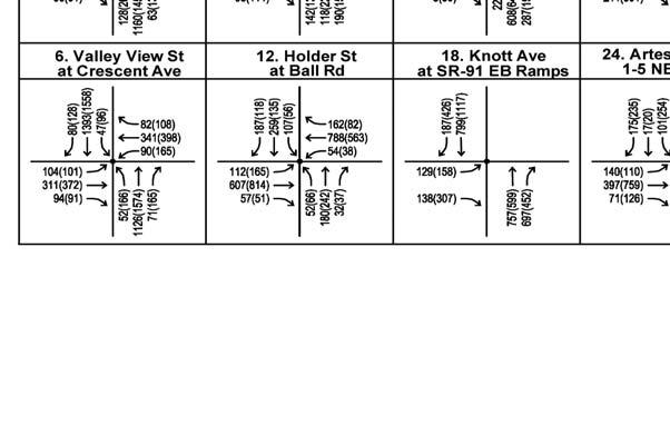
12 STUDY AREA Fifty-nine (59) intersections were selected for analysis of existing traffic conditions as well as future traffic conditions that would be anticipated when General Plan land uses would be builtout; refer to Exhibit 5.4-2, Study Intersections. The study intersections were selected based on the volume of peak hour traffic. Intersections with high peak hour volumes are those near activity centers and freeway interchanges, as well as those near vacant or underutilized parcels where development could occur and, in turn, cause increased traffic. EXISTING CONDITIONS TRAFFIC VOLUMES Study Intersections Existing lane configurations and traffic control at the study intersections were obtained through field observations, and are shown on Exhibit 5.4-3, Existing Lane Configurations and Traffic Control. Morning and evening peak hour traffic counts were conducted at the study intersections in fall 2008, and are depicted on Exhibit 5.4-4, Existing Peak Hour Traffic Volumes. The peak hours are the highest traffic volume hour within the morning peak period (7:00 AM to 9:00 AM) and the evening peak period (4:00 PM to 7:00 PM). ICU analyses were conducted to evaluate the existing operating conditions of the 59 intersections. The intersections and the resulting ICU values and corresponding LOS are summarized in Table 5.4-4, Summary of Existing Peak Hour Intersection Operations. Table Summary of Existing Peak Hour Intersection Operations Int. # Segment Control AM Peak Hour PM Peak Hour Delay / ICU LOS Delay / ICU LOS Valley View Street 1 Artesia Boulevard S C B 2 Orangethorpe Avenue S A B 3 SR-91 WB Ramps S 22.2 C 22.1 C 4 SR-91 EB Ramps S 3.0 A 6.7 A 5 La Palma Avenue S A C 6 Crescent Avenue S A B 7 Lincoln Avenue S B B 8 Ball Road S C C 9 Cerritos Avenue S D D Holder Street 10 Crescent Avenue S A A 11 Lincoln Avenue S A A 12 Ball Road S A A 13 Cerritos Avenue S A A Draft EIR Page Buena Park General Plan Update September 2010
13 Table [continued] Summary of Existing Peak Hour Intersection Operations Int. # Segment Control AM Peak Hour PM Peak Hour Delay / ICU LOS Delay / ICU LOS Knott Avenue 14 Firestone Boulevard U 12.2 B 19.9 C 15 Artesia Blvd/I-5 SB Off-Ramp S 26.1 C 27.5 C 16 Orangethorpe Avenue S A A 17 SR-91 WB Ramps S 22.6 C 28.8 C 18 SR-91 EB Ramps S 7.6 A 14.9 B 19 La Palma Avenue S B C 20 Crescent Avenue S B B 21 Lincoln Avenue S B D 22 Orange Avenue S B B Artesia Boulevard 23 I-5 SB On-Ramp U A A 24 Firestone Blvd/I-5 NB On-Ramp S 30.7 C 29.5 C Western Avenue 25 Lincoln Avenue S A A La Mirada Boulevard 26 Alondra Boulevard S B C Beach Boulevard 27 Rosecrans Avenue S 43.9 D 70.7 E 28 Malvern Avenue S 45.0 D 44.5 D 29 Stage Road S 18.3 B 20.0 C 30 Franklin Street S 10.9 B 11.4 B 31 Artesia Boulevard S 38.7 D 39.8 D 32 Commonwealth Avenue S 13.6 B 16.8 B 33 Auto Center Drive S 30.3 C 37.4 D 34 I-5 Ramps S 18.4 B 16.6 B 35 Orangethorpe Avenue S 32.7 C 35.5 D 36 SR-91 WB Ramps S 26.1 C 32.2 C 37 SR-91 EB Ramps S 22.0 C 23.1 C 38 La Palma Avenue S 29.2 C 37.1 D 39 Crescent Avenue S 23.3 C 31.1 C 40 Stanton Avenue S 12.3 B 14.0 B 41 Lincoln Avenue S 29.2 C 32.9 C Stanton Avenue 42 Malvern Avenue S C D 43 Artesia Boulevard S A B 44 Commonwealth Avenue S A A 45 Whitaker Street S A A 46 Auto Center Drive S A B 47 Orangethorpe Avenue S B A Page September 2010 Draft EIR Buena Park General Plan Update
14 Table [continued] Summary of Existing Peak Hour Intersection Operations Int. # Segment Control AM Peak Hour Traffic and Circulation PM Peak Hour Delay / ICU LOS Delay / ICU LOS Stanton Avenue 48 La Palma Avenue S A A 49 Crescent Avenue S A A Auto Center Drive 50 I-5 Off-Ramp S 24.8 C 25.5 C Dale Street 51 Malvern Avenue S C A 52 Lakeknoll Drive S A A 53 Artesia Boulevard S A A 54 Commonwealth Avenue S A A 55 La Palma Avenue S B B 56 Crescent Avenue S A A 57 Lincoln Avenue S A A Magnolia Avenue 58 La Palma Avenue S B C 59 Crescent Avenue S B B Note: ICU = Intersection Capacity Utilization, U = unsignalized, S = signalized. Deficient intersection operation shown in bold. Source: Kimley-Horn and Associates, Inc., City of Buena Park General Plan Update, Circulation-Existing Conditions, June As indicated in Table 5.4-4, all study intersections are currently operating at LOS D or better under existing conditions with the exception of the intersection of Beach Boulevard and Rosecrans Avenue, which is operating at a deficient LOS, LOS E, during the PM peak hour. Roadway Segments Existing traffic volumes were compared to the roadway capacity to assess existing LOS. This analysis is based on the average daily traffic (ADT) counts obtained from the City of Buena Park 2008 ADT Volume Map and the Orange County Transportation Authority (OCTA) 2007 Traffic Flow Map. The existing daily traffic volumes on roadway segments are presented in Exhibit 5.4-5, Existing Daily Traffic Volumes. For each roadway segment, the daily capacity is determined according to the current roadway type and existing number of lanes (based on the criteria established in the Orange County Highway Design Manual). Existing daily traffic volumes and the corresponding LOS for each roadway segment are summarized in Table 5.4-5, Summary of Existing Roadway Segment Operations. As indicated in Table the majority of roadway segments throughout the City are currently operating at LOS D or better under existing conditions. The following segments currently operate at LOS E under existing conditions: Beach Boulevard, between SR-91 and Orangethorpe Avenue; Beach Boulevard, between Orangethorpe Avenue and I-5 Freeway; and Malvern Avenue, between Stanton Avenue and Dale Street. Draft EIR Page Buena Park General Plan Update September 2010
15 Source: Kimley-Horn Associates, Inc., October NOT TO SCALE 09/10 JN ENVIRONMENTAL IMPACT REPORT BUENA PARK GENERAL PLAN UPDATE Study Intersections Exhibit 5.4-2


16 Source: Kimley-Horn Associates, Inc., October /10 JN ENVIRONMENTAL IMPACT REPORT BUENA PARK GENERAL PLAN UPDATE Existing Lane Configurations and Traffic Control Exhibit 5.4-3
17 This page intentionally left blank. Page September 2010 Draft EIR Buena Park General Plan Update


18 Source: Kimley-Horn Associates, Inc., October /10 JN ENVIRONMENTAL IMPACT REPORT BUENA PARK GENERAL PLAN UPDATE Existing Peak Hour Traffic Volumes Exhibit 5.4-4
19 This page intentionally left blank. Page September 2010 Draft EIR Buena Park General Plan Update
20 Source: Kimley-Horn Associates, Inc., October NOT TO SCALE 09/10 JN ENVIRONMENTAL IMPACT REPORT BUENA PARK GENERAL PLAN UPDATE Existing Daily Traffic Volumes Exhibit 5.4-5
21 Table Summary of Existing Roadway Segment Operations Roadway Segment Classification ADT LOS Valley View Street between: Cerritos Avenue and Ball Road Major 44,000 C Lincoln Avenue and Crescent Avenue Principal 40,000 A Crescent Avenue to La Palma Avenue Principal 40,000 A La Palma Avenue and Orangethorpe Avenue Principal 45,000 A Orangethorpe Avenue and Artesia Boulevard Major 30,000 A Knott Avenue between: Lincoln Avenue and Crescent Avenue Primary 28,000 C Crescent Avenue and La Palma Avenue Primary 29,000 C La Palma Avenue and Orangethorpe Avenue Primary 33,000 D Orangethorpe Avenue and Artesia Boulevard Primary 21,000 A Western Avenue between: Lincoln Avenue and Crescent Avenue Secondary 18,000 C Crescent Avenue and La Palma Avenue Secondary 18,000 C La Palma Avenue and Orangethorpe Avenue Secondary 17,000 B Orangethorpe Avenue and Commonwealth Avenue Secondary 20,000 C Commonwealth Avenue and Artesia Boulevard Secondary 20,000 C Beach Boulevard between: South of Crescent Avenue Principal 61,000 D Crescent Avenue and La Palma Avenue Principal 61,000 D La Palma Avenue and SR-91 Principal 59,000 C SR-91 and Orangethorpe Avenue Major 52,000 E Orangethorpe Avenue and I-5 Major 52,000 E I-5 and Commonwealth Avenue Major 46,000 D Commonwealth Avenue and Artesia Boulevard Major 50,000 D Artesia Boulevard and Stage Road Major 58,000 F Stage Road and La Mirada Boulevard Major 48,000 D North of La Mirada Boulevard Major 48,000 D Stanton Avenue between: Crescent Avenue and La Palma Avenue Primary 15,000 A La Palma Avenue and Orangethorpe Avenue Secondary 14,000 A Orangethorpe Avenue and Whitaker Street Secondary 17,000 B Whitaker Street and Artesia Boulevard Secondary 16,000 B Dale Street between: Crescent Avenue and La Palma Avenue Secondary 11,000 A La Palma Avenue and south of SR-91 Freeway Secondary 5,000 A Auto Center Drive and Commonwealth Avenue Secondary 6,000 A Commonwealth Avenue and Artesia Boulevard Secondary 16,000 B North of Artesia Boulevard Secondary 9,000 A Page September 2010 Draft EIR Buena Park General Plan Update
22 Table [continued] Summary of Existing Roadway Segment Operations Traffic and Circulation Roadway Segment Classification ADT LOS Cerritos Avenue between: Valley View Street and Holder Street Secondary 16,000 B Ball Road between: Holder Street and west of Knott Avenue Primary 17,000 A Orange Avenue between: Holder Street and west of Knott Avenue Secondary 12,000 A Lincoln Avenue between: Valley View Street and Holder Street Major 21,000 A Holder Street and Knott Avenue Major 21,000 A Crescent Avenue between: West of Valley View Street Secondary 13,000 A Valley View Street and Holder Street Secondary 12,000 A Holder Street and Knott Avenue Secondary 12,000 A Knott Avenue and Western Avenue Secondary 13,000 A Western Avenue and Beach Boulevard Secondary 13,000 A Beach Boulevard and Dale Street Secondary 10,000 A La Palma Avenue between: Valley View Street and Knott Avenue Primary 17,000 A Knott Avenue and Western Avenue Primary 21,000 A Western Avenue and Beach Boulevard Primary 21,000 A Beach Boulevard and Dale Street Primary 27,000 C Orangethorpe Avenue between: Valley View Street and Knott Avenue Major 19,000 A Knott Avenue and Western Avenue Major 23,000 A Western Avenue and Beach Boulevard Major 24,000 A Beach Boulevard and Stanton Avenue Major 19,000 A Stanton Avenue and Dale Street Major 19,000 A Commonwealth Avenue between: Western Avenue and Beach Boulevard Primary 6,000 A Beach Boulevard and Dale Street Primary 13,000 A Artesia Boulevard between: Valley View Street and Knott Avenue Primary 23,000 B Knott Avenue and Western Avenue Secondary 22,000 D Western Avenue and Beach Boulevard Secondary 22,000 D Beach Boulevard and Dale Street Secondary 14,000 A La Mirada Boulevard between: West of Beach Boulevard Primary 33,000 D Malvern Avenue between: Beach Boulevard and Stanton Avenue Primary 26,000 B Stanton Avenue and Dale Street Primary 34,000 E East of Dale Street Primary 26,000 B Draft EIR Page Buena Park General Plan Update September 2010
23 Table [continued] Summary of Existing Roadway Segment Operations Roadway Segment Classification ADT LOS Stage Road between: West of Beach Boulevard Secondary 8,000 A Holder Street between: Cerritos Avenue and Ball Road Secondary 6,000 A Ball Road and Orange Avenue Secondary 9,000 A Orange Avenue and Lincoln Avenue Secondary 10,000 A Lincoln Avenue and Crescent Avenue Secondary 15,000 A Auto Center Drive between: Western Avenue and Beach Boulevard Secondary 5,000 A Beach Boulevard and Orangethorpe Avenue Secondary 8,000 A Additionally, the following roadway segment is currently operating at LOS F under existing conditions: Beach Boulevard, between Artesia Boulevard and Stage Road. BIKEWAYS, TRAILS, AND PEDESTRIAN FACILITIES Bikeways The City does not currently have a formal Bicycle Master Plan, and City streets are generally not equipped with designated bicycle facilities. The City s current General Plan identifies a portion of the Brea Creek Channel, east of Dale Street, in the northern portion of the City, as a bike path. There is a Class I segment along Malvern Avenue. The current General Plan identified 12 proposed bike routes throughout the City. However, these proposed bike routes have not been completed to date. Trails The City currently does not have a trails system. The Southern California Edison (SCE) easement, located to the north of La Palma Avenue, forms a linear path trending east/west through the City that is used as passive and active open space. However, this linear path does not provide connectivity to other trails or specific destinations within the City. Pedestrian Sidewalks are provided on all arterial roadways and on the majority of residential streets. The City s circulation system has been designed to ensure that adequate facilities are provided for pedestrian circulation, especially in the vicinity of the Entertainment Corridor, as well as schools, parks, major retail facilities, and other locations with high levels of pedestrian activity. It is the City s goal to construct new sidewalks/wheelchair ramps as well as modify existing sidewalks/ wheelchair ramps to comply with the American with Disabilities Act (ADA). When streets do Page September 2010 Draft EIR Buena Park General Plan Update
24 not have sufficient right-of-way for ADA compliant sidewalks and wheelchair ramps, the City will acquire easements as dedications from land owners through a private development process. PARK AND RIDE FACILITIES The Fullerton Park-N-Ride facility is located at the southwest corner of Orangethorpe Avenue and Magnolia Avenue, just north of the I-5/SR-91 interchange. This facility also supports the Buena Park Metrolink Station via shuttle service provided by OCTA. PUBLIC TRANSIT The City of Buena Park is well served by public transit systems. Local and regional bus service is provided by OCTA. Additionally, there is a Metrolink regional commuter rail line station located at Lakeknoll Drive and Dale Street in the northeast portion of the City. Local Fixed-Route Services ORANGE COUNTY TRANSPORTATION AUTHORITY OCTA operates Routes 21, 24, 25, 26, 29, 38, 42/42A and 46 in the City of Buena Park; refer to Exhibit 5.4-6, Existing Transit Routes. Route 21. OCTA Route 21 operates between the City of Fullerton and the City of Huntington Beach along Valley View Street and Bolsa Chica Road in a northbound/southbound direction. Route 21 originates in the Fullerton Park-N-Ride lot located at the corner of Orangethorpe Avenue and Magnolia Avenue. Route 21 then continues west through the City of Buena Park on Commonwealth Boulevard and Artesia Boulevard and heads south on Valley View Street through the cities of Cypress, Garden Grove, Westminster and Huntington Beach; it then turns onto Bolsa Chica Road and continues to the end of the route at Warner Avenue and PCH. Route 21 operates five days per week, from 4:40 AM to 10:00 PM on weekdays, with 40 to 60 minute headways (intervals between bus arrivals) throughout the day. Route 24. OCTA Route 24 operates between the City of Fullerton and the City of Orange along Malvern Avenue, Chapman Avenue, and Tustin Avenue in an eastbound/westbound direction. Route 24 originates in the Fullerton Park-N-Ride lot, continues east on Malvern Avenue and Chapman Avenue through the cities of Buena Park, Anaheim, Placentia, where it then turns onto Tustin Avenue and continues south to the Village at Orange. Route 24 operates seven days a week, from 4:50 AM to 11:00 PM on weekdays and 7:00 A.M. to 9:00 PM on weekends and holidays, with 20 to 60 minute headways throughout the day. Route 25. OCTA Route 25 operates in a northbound/southbound direction between the City of Fullerton and the City of Huntington Beach via Knott Avenue/Goldenwest Street. Route 25 originates in the Fullerton Park-N-Ride lot and continues west to the City of Buena Park where it heads south on Knott Avenue through the cities of Cypress and Garden Grove. Route 25 turns around at PCH and 1st Street in the Downtown Huntington Beach area. Route 25 operates seven days a week, from 4:50 AM to 11:00 PM on weekdays and 7:20 AM to 7:40 PM on weekends, with 15 to 60 minute headways throughout the day. Draft EIR Page Buena Park General Plan Update September 2010


25 Source: Kimley-Horn Associates, Inc., October NOT TO SCALE 09/10 JN ENVIRONMENTAL IMPACT REPORT BUENA PARK GENERAL PLAN UPDATE Existing Transit Routes Exhibit 5.4-6
26 Route 26. OCTA Route 26 operates between the City of Fullerton and City of Yorba Linda via Commonwealth Avenue and Yorba Linda Avenue in an eastbound/westbound direction. Route 26 originates in the Fullerton Park-N-Ride lot and continues east on Commonwealth Avenue through the cities of Buena Park, Fullerton, and Placentia, where it continues east on Yorba Linda Boulevard to the North Orange County Community College District facility on Fairmont Boulevard. Route 26 operates seven days a week, from 5:00 AM to 10:45 PM on weekdays and 7:45 AM to 7:15 PM on weekends, with 30 minute headways throughout the day. Route 29. OCTA Route 29 operates between the City of Brea and the City of Huntington Beach along La Habra Boulevard, within the City of La Habra, and Central Avenue, within the City of Brea, and Beach Boulevard in a northbound/southbound direction. Route 29 originates near the Brea Mall and continues west on Central Avenue through to the City of Brea, then heads south on Beach Boulevard through the cities of Buena Park, Anaheim, Stanton, Garden Grove, Westminster, and Huntington Beach; where it turns northbound at PCH. Route 29 then makes a loop at 1st Street in Huntington Beach before returning to Brea along the same route. Route 29 operates seven days a week, from 4:00 AM to 12:30 AM on weekdays and 4:30 AM to 11:40 PM on weekends, with 10 to 30 minute headways throughout the day. Route 38. OCTA Route 38 operates between the City of Lakewood and the City of Anaheim Hills along Del Amo Boulevard/La Palma Avenue in an eastbound/westbound direction. Route 38 originates at Del Amo Boulevard and Pioneer Avenue and continues east on La Palma Avenue through the cities of Cerritos, La Palma, Buena Park, and Anaheim; where it turns around at the Anaheim Hills Festival Shopping Center. Route 38 operates seven days a week, from 3:35 AM to 12:55 AM on weekdays and 4:30 AM to 9:10 PM on weekends, with 10 to 20 minute headways throughout the day. Route 42/42A. OCTA Route 42/42A operates between the City of Seal Beach and the City of Orange via Seal Beach Boulevard, Los Alamitos Boulevard, and Lincoln Avenue in an eastbound/westbound direction. Route 42 originates at PCH and Balboa Drive in the City of Seal Beach and continues north on Los Alamitos Boulevard through the Cities of Los Alamitos, Long Beach, and Hawaiian Gardens; it then turns onto Lincoln Avenue and continues east through the Cities of Cypress, Buena Park, Anaheim, and Orange, where it turns around at the Village at Orange. Route 42/42A operates seven days a week, from 4:20 AM to 11:55 PM on weekdays and 5:40 AM to 9:15 PM on weekends, with 5 to 15 minute headways throughout the day. Route 46. OCTA Route 46 operates between the City of Long Beach and the City of Orange via Ball Road and Taft Avenue in an eastbound/westbound direction. Route 46 originates at Norwalk Boulevard and Wardlow Road in Long Beach and continues east on Ball Road and Taft Avenue through the Cities of Los Alamitos, Cypress, Buena Park, Anaheim, and Orange; it then turns around at the Village at Orange. Route 46 operates seven days a week, from 4:30 AM to 11:45 PM on weekdays and 6:35 AM to 8:20 PM on weekends, with 20 to 30 minute headways throughout the day. COMMUTER SERVICE Rail The Buena Park Metrolink station is located on Lakeknoll Drive, west of Dale Street and north of Artesia Boulevard in the northeast portion of the City. The Buena Park station is served by two Metrolink lines: the Orange County Line, which begins in Oceanside in San Diego County; and Draft EIR Page Buena Park General Plan Update September 2010
27 the 91 Line, which begins in Riverside County. From Buena Park, both lines head north to Union Station in downtown Los Angeles. Metrolink operates seven days a week, from 4:00 AM to 8:30 PM on weekdays and 6:20 AM to 10:45 PM on weekends. The Buena Park station has a 300-space parking lot. A shuttle service between the Buena Park Metrolink station and the Fullerton Park-and-Ride is offered every weekday during the peak commute hours at 10-minute intervals. GOODS MOVEMENT Trucking Truck traffic in the City of Buena Park is restricted on local streets, and on other weightrestricted streets marked by signage. The designation of truck routes is intended to route truck traffic on City arterials so that trucks cause the least amount of neighborhood disruption. Roadways providing access to the freeways are those most likely to be designated for truck routes. Large trucks may generally use any of the City roadways that are designated as principal, major, or primary highways. However, multiple selected roadways, such as Beach Boulevard, Valley View Street, and Orangethorpe Avenue have been specifically designated as truck routes. The designation of truck route does not prevent trucks from using other roads or streets to make deliveries to individual addresses, or for other reasons as defined in the Motor Vehicle Code of the State of California. AIR TRANSPORTATION Fullerton Municipal Airport (FUL) The Fullerton Municipal Airport is located between Artesia Boulevard and Commonwealth Avenue, and adjoins the eastern boundary of the northern portion of the City of Buena Park. The Fullerton Airport, founded in 1927, is the only general aviation airport (all civilian flying except scheduled passenger airlines) in the County, and is self-supporting. Revenues from the airport fund the cost of operations and maintenance, with the surplus going into the enterprise Airport Fund. The airport occupies 86 acres in the City of Fullerton, has a runway length of 3,120 feet, and has an aircraft capacity of 600 planes. 2 Los Alamitos Joint Forces Training Base (JFTB) The Los Alamitos Joint Forces Training Base (JFTB), operated by the National Guard Bureau, is located within the southwestern portion of Los Alamitos. The 1,400 acre facility contains two runways with approximately 1,100 flights that arrive or depart every month. The airfield is a restricted area and is primarily utilized by military aircraft REGULATORY FRAMEWORK The City of Buena Park is located in northwestern portion of Orange County and is bordered on the east by the City of Fullerton, on the south by the Cities of Anaheim and Cypress, and on the City of Fullerton official website, accessed at on June 23, Page September 2010 Draft EIR Buena Park General Plan Update
28 northwest by the City of La Mirada. Many of the arterial roadways trending through the City extend beyond the City boundaries into neighboring cities. Therefore, circulation issues and travel patterns extend beyond the City limits. Land use decisions and traffic patterns in adjacent jurisdictions have the potential to affect traffic flow and mobility in the City of Buena Park, and conversely, traffic conditions and decisions made by the City of Buena Park can affect other jurisdictions. REGIONAL TRANSPORTATION IMPROVEMENT PROGRAM The Regional Transportation Improvement Program (RTIP) is the Southern California Association of Government s compilation of state, federal, and local funded transportation projects. In addition to projects identified in the State Transportation Improvement Program (STIP), the RTIP includes federal Congestion Mitigation and Air Quality Improvement (CMAQ) and Surface Transportation Program (STP) funds, other federal funds, and projects entirely funded out of local and private funds. The RTIP identifies all transportation projects proposed over a six-year period for the Southern California Association of Governments (SCAG) region. The projects include highway improvements, transit, rail and bus facilities, high occupancy vehicle lanes, signal synchronization, intersection improvements, and freeway ramps. CALIFORNIA STATE SENATE BILL 375 (SB 375) California State Senate Bill 375 (SB 375) became law effective January 1, 2009 as implementing legislation of Assembly Bill 32 (AB 32), which requires the state to reduce Greenhouse Gas (GHG) emissions across all industry sectors back to 1990 levels by the year Both laws are administered and enforced through the California Air Resources Board (CARB); refer also to the Conservation and Sustainability Element. Given that the transportation sector is the largest contributor to GHG pollution throughout California, SB 375 targets reduction of GHG emissions specific to cars and light trucks. The law requires each of the State s 18 Metropolitan Planning Organizations (MPO) to develop a Sustainable Communities Strategy (SCS), which will include specific strategies for improving land use and transportation efficiency. The most prominent strategy includes the identification and development of higher density, mixed-use projects around public transportation system stations. Other supported strategies relate to the integration of Intelligent Transportation Systems (ITS) to improve circulation on freeways and arterials. Every SCS to be developed under SB 375 is required to be integrated into each MPO s Regional Transportation Plan (RTP), thus encouraging local jurisdictions to comply. Transportation improvement projects not listed in the RTP become ineligible to receive funding from some state and federal programs. CONGESTION MANAGEMENT PROGRAM The purpose of the Orange County Congestion Management Program (CMP) is to develop a coordinated approach to managing and decreasing traffic congestion by linking the various transportation, land use, and air quality planning programs throughout the County. The City of Buena Park is required to show continued compliance with the countywide CMP. The benefits of compliance with the CMP provisions include the allocation of the City's fair share of gas tax subventions collected by the State of California. Draft EIR Page Buena Park General Plan Update September 2010
29 MEASURE M AND RENEWED MEASURE M In 1990, Orange County voters approved Measure M, a 20-year program for transportation improvements funded by a half-cent sales tax. Measure M allocates all sales tax revenues to specific Orange County transportation improvement projects in three major areas - freeways, streets and roads, and transit. In 2006, Orange County voters approved the renewal of Measure M from 2011 to Revenue generated by Measure M is returned to local jurisdictions for use on local and regional transportation improvement and maintenance projects. Each jurisdiction is required to comply with the Countywide Traffic Improvement and Growth Management Program to receive the revenue. Pursuant to Measure M policy requirements, Buena Park must satisfy the following specific requirements to be eligible for receiving Measure M funds: Adopt a Growth Management Program into its General Plan that addresses the following: - Traffic level of service standards; - A development mitigation program; - Participation in Inter-Jurisdictional Planning Forums; - Development of a Seven Year Capital Improvement Program; and - A Transportation Demand Management (TDM) Ordinance. Adopt a Local TDM Ordinance. Agree to expend all Measure M revenues within three years of receipt. Adopt a Traffic Circulation Plan (General Plan Circulation Element) consistent with the Orange County Master Plan of Arterial Highways. Adopt and fund a Local Pavement Management Plan. Satisfy the Maintenance of Effort requirements. Adopt a Seven-Year Capital Improvement program. The Measure M program has provided for several projects within and around Buena Park, including construction on the I-5 Gateway Project to eliminate the bottleneck through the City, Buena Park Metrolink station, and bus fare discounts to seniors and persons with disabilities. SMART STREET PROGRAM The Smart Street concept seeks to improve roadway traffic capacity and smooth traffic flow through measures such as traffic signal synchronization, bus turnouts, intersection improvements, and addition of travel lanes by removing on-street parking and consolidating driveways. Along with the State highways, the Smart Street network comprises the CMP highway system, the performance of which determines compliance with CMP level of service (LOS) thresholds. This special street designation allows for the development of improvements that enhance the traffic carrying capacity of this roadway in excess of the Major arterial designation. A dedicated funding source for Smart Streets projects is included in Measure M. Beach Boulevard was the first Smart Street project to be implemented. Smart Streets within the City of Buena Park include: Beach Boulevard; Valley View Street; and Orangethorpe Avenue. Page September 2010 Draft EIR Buena Park General Plan Update
30 5.4.3 SIGNIFICANCE THRESHOLD CRITERIA The environmental analysis in this section is patterned after the Environmental Checklist recommended by the CEQA Guidelines, as amended, and used by the City of Buena Park in its environmental review process. Since issuance of the Initial Study/Notice of Preparation (contained in Appendix A of the EIR), the CEQA Guidelines have been amended, resulting in revisions to the Environmental Checklist questions relating to transportation and traffic. The issues presented in the Initial Study Checklist (Appendix G of the CEQA Guidelines), as amended, have been utilized as thresholds of significance in this section. Accordingly, a project may create a significant environmental impact if it causes one or more of the following to occur: Conflict with an applicable plan, ordinance or policy establishing measures of effectiveness for the performance of the circulation system, taking into account all modes of transportation including mass transit and non-motorized travel and relevant components of the circulation system, including but not limited to intersections, streets, highways and freeways, pedestrian and bicycle paths, and mass transit; Conflict with an applicable congestion management program, including, but not limited to level of service standards and travel demand measures, or other standards established by the county congestion management agency for designated roads or highways; Result in a change in air traffic patterns, including either an increase in traffic levels or a change in location that results in substantial safety risks (refer to Section 8.0, Effects Found Not To Be Significant); Substantially increase hazards due to a design feature (e.g., sharp curves or dangerous intersections) or incompatible uses (e.g., farm equipment); Result in inadequate emergency access; and/or Conflict with adopted policies, plans, or programs regarding public transit, bicycle, or pedestrian facilities, or otherwise decrease the performance or safety of such facilities. Based on these standards, the effects of the proposed project have been categorized as either a less than significant impact or a potentially significant impact. Mitigation measures are recommended for potentially significant impacts. If a potentially significant impact cannot be reduced to a less than significant level through the application of mitigation, it is categorized as a significant unavoidable impact IMPACTS AND MITIGATION MEASURES PROPOSED GENERAL PLAN UPDATE TRAFFIC OPERATIONS IMPLEMENTATION OF THE PROPOSED GENERAL PLAN UPDATE COULD CONFLICT WITH AN APPLICABLE PLAN, ORDINANCE, OR POLICY ESTABLISHING MEASURES OF EFFECTIVENESS FOR INTERSECTIONS. Draft EIR Page Buena Park General Plan Update September 2010
31 Impact Analysis: FORECAST METHODOLOGY Analysis of the projected traffic conditions at buildout of the City was conducted to determine whether or not the City s circulation system can accommodate the future traffic demands of buildout, including the land use changes proposed by the General Plan Update. For this analysis, buildout assumes the City will be built-out to its General Plan potential, and that the proposed land use plans for the Focus Areas are realized. Additionally, each intersection is assumed to be built-out to its master plan ultimate configuration. Buildout lane geometry assumptions are identified on Exhibit 5.4-7, Buildout Lane Configurations and Traffic Control. An asterisk indicates the additional lanes that are currently not in place, and that would be needed to achieve the buildout configuration. If roadway or intersection deficiencies are projected to occur as a result of the proposed General Plan Update, additional improvements needed to accommodate future traffic volumes are identified. Baseline General Plan forecasts were derived from the Orange County Traffic Analysis Model (OCTAM 3.2). OCTAM is a regional model covering the entire County of Orange. The model contains socio-economic data and transportation network assumptions that reflect the current General Plan or each city in Orange County. Baseline traffic forecasts represent traffic levels that would result from buildout of the region based on current General Plan land use plans. To evaluate the land uses changes proposed by the General Plan Update, changes in traffic that would result from the proposed land use changes in the Focus Areas were applied to the baseline forecasts. Focus Area Trip Generation The changes in land use mix proposed by the General Plan Update include a reduction of some land uses, the conversion of one land use from one use to another, some intensification of density for some land uses, and in some cases, a re-designation of land use type. For the analysis of future traffic conditions, each Focus Area is divided into a number of sub-areas. Each sub-area was quantified in terms of its proposed future land use, including the land use type (i.e., residential, retail, office, etc.) and the quantity of those land uses (dwelling units, square feet). The trip making potential for the proposed buildout is quantified by Traffic Analysis Zone (TAZ), sub-area, and Focus Area, first applying standard trip generation rates for each land use, and then applying appropriate factors to account for mode split, pass-by potential, and for the mixed-use nature of the proposed land uses. One characteristic of multi-use developments is the potential for beneficial interactions among site uses in terms of walk/bike trips or shared vehicular trips between land uses. These interactions represent the potential for a reduction in the number of new trips assumed for the new development. For example, patrons of a proposed hotel development or of a proposed visitor-serving entertainment development may also patronize a new commercial development. Vehicular trips between the hotel/residential uses and the entertainment and commercial uses could be contained within the project area, and would not contribute to traffic growth at off-site intersections. Walking and biking trips between uses would represent elimination of a vehicular trip altogether. Shuttle activity between hotels and entertainment centers would further reduce vehicular trips. This potential for reduction in vehicle trips is known as internal capture and mode shift. As a result of these factors, the total inbound and outbound vehicular trips for the project may be reduced. Varying internal capture and mode shift factors were applied to the different Focus Areas, depending on the mix, proximity, and quantity of complementary uses proposed. Page September 2010 Draft EIR Buena Park General Plan Update
32 Source: Kimley-Horn Associates, Inc., August /10 JN ENVIRONMENTAL IMPACT REPORT BUENA PARK GENERAL PLAN UPDATE Buildout Lane Configurations and Traffic Control Exhibit 5.4-7
33 This page intentionally left blank. Page September 2010 Draft EIR Buena Park General Plan Update
34 It is also recognized that not all trips into and out of a proposed project will be new trips on the roadway system in the vicinity of a project. Some trips to the project area will consist of passby trips; motorists who are already traveling on the surrounding roadways from one place to another and who stop at the project site on their way. Common pass-by trips for a commercial center would be individuals who stop to shop or run errands on their way to or form work or school or destinations in the Entertainment area. Table 5.4-6, Trip Generation by Focus Area, summarizes the project trips by Focus Area. The proposed land use mix for the Focus Areas has the potential to generate approximately 8,027 new trips in the morning peak hour and approximately 14,449 new trips in the evening peak hour; refer to Appendix C for detailed trip generation calculations. The traffic analysis is intended to provide an evaluation of traffic impacts associated with buildout of the proposed General Plan Update. Buildout land uses were categorized by Focus Area and sub-area and aggregated into TAZ. The distribution assumptions for each TAZ include a combination of assignments to multiple destinations within the City and destinations external to the City; refer to Appendix C for detail trip distribution assumptions for each TAZ. Exhibit 5.4-8, General Plan Buildout Peak Hour Turning Movement Forecasts, shows the buildout forecasts at the study intersections with the trips assigned from each of the Focus Areas. Buildout Traffic Projections The additional trips that would be generated by buildout of the proposed land uses in the Focus Areas were estimated and distributed on the surrounding road network as previously described. Interaction between complementary land uses within the City and pass-by assumptions, were taken into account in the distribution and assignment of traffic. STUDY INTERSECTIONS BUILDOUT TRAFFIC CONDITIONS Table 5.4-7, General Plan Buildout Peak Hour Intersection Operations HCM Methodology, identifies the LOS for the study intersections using the HCM methodology. Table 5.4-8, General Plan Buildout Peak Hour Intersection Operations ICU Methodology, identifies the LOS for the study intersections using the ICU methodology. As indicated in Table and Table 5.4-8, the following intersections are forecast to operate at an unacceptable LOS (LOS F for CMP intersections, LOS E or LOS F for all other intersections) for one or both analysis methodologies. Deficient Intersection Methodology 1. Valley View Street at Artesia Boulevard HCM, ICU 2. Valley View Street at Orangethorpe Avenue HCM, ICU 5. Valley View Street at La Palma Avenue HCM, ICU 6. Valley View Street at Crescent Avenue HCM, ICU 7. Valley View Street at Lincoln Avenue HCM 9. Valley View Street at Cerritos Avenue ICU 12. Holder Street at Ball Road HCM 19. Knott Avenue at La Palma Avenue HCM, ICU 20. Knott Avenue at Crescent Avenue HCM, ICU 21. Knott Avenue at Lincoln Avenue HCM, ICU Draft EIR Page Buena Park General Plan Update September 2010
35 Table Trip Generation by Focus Area Focus Area Central Civic Center Entertainment Corridor Commonwealth Corridor Entertainment Corridor North North Beach North West Area Orangethorpe East Orangethorpe West Traffix Zone Daily Trip Generation Estimates 1 AM Peak Hour PM Peak Hour In Out Total In Out Total 900 1, , , Subtotal 4, Subtotal , , , , , , , , , , Subtotal 119,903 1, ,221 3,289 3,588 6, , Subtotal -2, , , , , ,919 Subtotal 38, ,236 1,197 1,275 2, Subtotal ,981 2, , ,840 2, , , Subtotal 14,610 2, , ,406 2, , , Subtotal 6, , , , , Subtotal 26, ,193 Total 207,169 6,140 1,887 8,027 5,672 8,777 14,449 1 Trip Generation Estimates were calculated using the Institute of Transportation Engineers publication Trip Generation, 8th Edition. Page September 2010 Draft EIR Buena Park General Plan Update


36 Source: Kimley-Horn Associates, Inc., August /10 JN ENVIRONMENTAL IMPACT REPORT BUENA PARK GENERAL PLAN UPDATE General Plan Buildout Peak Hour Turning Movement Forecasts Exhibit 5.4-8
37 This page intentionally left blank. Page September 2010 Draft EIR Buena Park General Plan Update
38 Table General Plan Buildout Peak Hour Intersection Operations HCM Methodology Int. # Intersection Control AM Peak Hour PM Peak Hour Delay LOS Delay LOS Valley View Street 1 Artesia Boulevard S 78.6 E 84.4 F 2 Orangethorpe Avenue S 81.5 F 83.2 F 3 SR-91 WB Ramps S 47.9 D 56.4 E 4 SR-91 EB Ramps S 6.7 A 18.1 B 5 La Palma Avenue S 37.2 D 77.0 E 6 Crescent Avenue S 52.9 D 55.9 E 7 Lincoln Avenue S 45.7 D 61.9 E 8 Ball Road S 40.7 D 44.8 D 9 Cerritos Avenue S 49.0 D 46.1 D Holder Street 10 Crescent Avenue S 28.8 C 34.9 C 11 Lincoln Avenue S 33.8 C 32.8 C 12 Ball Road S 66.9 E 59.2 E 13 Cerritos Avenue S 24.8 C 37.1 D Knott Avenue 14 Firestone Boulevard U 12.7 B 23.1 C 15 Artesia Blvd/I-5 SB Off-Ramp S 37.0 D 45.0 D 16 Orangethorpe Avenue S 40.4 D 45.2 D 17 SR-91 WB Ramps S 29.9 C 36.6 D 18 SR-91 EB Ramps S 17.0 B 25.2 C 19 La Palma Avenue S 46.1 D 87.0 F 20 Crescent Avenue S 39.7 D 58.9 E 21 Lincoln Avenue S 47.9 D 90.0 F 22 Orange Avenue S 39.9 D 41.9 D Artesia Boulevard 23 I-5 SB On-Ramp U 14.3 B F 24 Firestone Blvd/I-5 NB On-Ramp S 43.9 D 39.4 D Western Avenue 25 Lincoln Avenue S 45.0 D 45.5 D La Mirada Boulevard 26 Alondra Boulevard S 35.5 D 32.5 C Beach Boulevard 27 Rosecrans Avenue S 49.2 D F 28 Malvern Avenue S F F 29 Stage Road S 39.6 D 48.4 D 30 Franklin Street S 30.8 C 27.3 C 31 Artesia Boulevard S 44.4 D F Draft EIR Page Buena Park General Plan Update September 2010
39 Table [continued] General Plan Buildout Peak Hour Intersection Operations HCM Methodology Int. # Intersection Control AM Peak Hour PM Peak Hour Delay LOS Delay LOS Beach Boulevard (continued) 32 Commonwealth Avenue S 21.2 C 24.9 C 33 (Manchester) Auto Center Drive S 38.4 D 74.1 E 34 I-5 Ramps S 29.8 C 32.7 C 35 Orangethorpe Avenue S 53.3 D F 36 SR-91 WB Ramps S 44.5 D F 37 SR-91 EB Ramps S 28.5 C F 38 La Palma Avenue S 48.9 D F 39 Crescent Avenue S 27.2 C 33.4 C 40 Stanton Avenue S 23.6 C 32.1 C 41 Lincoln Avenue S 44.5 D 57.5 E Stanton Avenue 42 Malvern Avenue S 21.9 C 20.9 C 43 Artesia Boulevard S 25.6 C 31.3 C 44 Commonwealth Avenue S 27.5 C 28.1 C 45 Whitaker Street S 13.8 B 9.3 A 46 (Manchester) Auto Center Drive S 29.4 C 48.3 D 47 Orangethorpe Avenue S 40.1 D 47.0 D 48 La Palma Avenue S 37.4 D 52.0 D 49 Crescent Avenue S 24.3 C 25.4 C (Manchester) Auto Center Drive 50 I-5 Off-Ramps S 22.0 C 17.3 B Dale Street 51 Malvern Avenue S 31.1 C 28.7 C 52 Lakeknoll Drive S 18.9 B 21.7 C 53 Artesia Avenue S 31.3 C 32.4 C 54 Commonwealth Avenue S 16.8 B 16.9 B 55 La Palma Avenue S 36.3 D 37.8 D 56 Crescent Avenue S 18.9 B 35.3 D 57 Lincoln Avenue S 41.3 D 50.8 D Magnolia Avenue 58 La Palma Avenue S 40.0 D 46.7 D 59 Crescent Avenue S 31.9 C 36.5 D Page September 2010 Draft EIR Buena Park General Plan Update
40 Table General Plan Buildout Peak Hour Intersection Operations ICU Methodology Int. # Intersection Control AM Peak Hour PM Peak Hour ICU LOS ICU LOS Valley View Street 1 Artesia Boulevard S 0.98 E 1.02 F 2 Orangethorpe Avenue S 0.95 E 0.96 E 3 SR-91 WB Ramps S 0.91 E 0.98 E 4 SR-91 EB Ramps S 0.60 A 0.85 D 5 La Palma Avenue S 0.74 C 0.95 E 6 Crescent Avenue S 0.84 D 0.92 E 7 Lincoln Avenue S 0.80 C 0.89 D 8 Ball Road S 0.76 C 0.82 D 9 Cerritos Avenue S 0.92 E 0.94 E Holder Street 10 Crescent Avenue S 0.72 C 0.80 C 11 Lincoln Avenue S 0.74 C 0.73 C 12 Ball Road S 0.85 D 0.88 D 13 Cerritos Avenue S 0.77 C 0.87 D Knott Avenue 14 Firestone Boulevard U N/A N/A N/A N/A 15 Artesia Blvd/I-5 SB Off-Ramp S 0.59 A 0.81 C 16 Orangethorpe Avenue S 0.73 C 0.83 D 17 SR-91 WB Ramps S 0.52 A 0.70 B 18 SR-91 EB Ramps S 0.52 A 0.70 B 19 La Palma Avenue S 0.87 D 1.08 F 20 Crescent Avenue S 0.84 D 0.98 E 21 Lincoln Avenue S 0.82 D 1.02 F 22 Orange Avenue S 0.79 C 0.82 D Artesia Boulevard 23 I-5 SB On-Ramp U N/A N/A N/A N/A 24 Firestone Blvd/I-5 NB On-Ramp S 0.58 A 0.57 A Western Avenue 25 Lincoln Avenue S 0.79 C 0.78 C La Mirada Boulevard 26 Alondra Boulevard S 0.77 C 0.69 B Beach Boulevard 27 Rosecrans Avenue S 0.91 D 1.20 F 28 Malvern Avenue S 1.15 F 1.15 F 29 Stage Road S 0.95 E 0.98 E 30 Franklin Street S 0.88 D 0.93 E 31 Artesia Boulevard S 0.94 E 1.12 F 32 Commonwealth Avenue S 0.67 B 0.73 C 33 (Manchester) Auto Center Drive S 0.69 B 0.90 D 34 I-5 Ramps S 0.72 C 0.80 C 35 Orangethorpe Avenue S 0.92 E 1.11 F 36 SR-91 WB Ramps S 0.86 D 1.24 F Draft EIR Page Buena Park General Plan Update September 2010
41 Table [continued] General Plan Buildout Peak Hour Intersection Operations ICU Methodology Int. # Intersection Control AM Peak Hour PM Peak Hour ICU LOS ICU LOS Beach Boulevard (continued) 37 SR-91 EB Ramps S 0.77 C 1.14 F 38 La Palma Avenue S 0.92 E 1.29 F 39 Crescent Avenue S 0.58 A 0.63 B 40 Stanton Avenue S 0.66 B 0.75 C 41 Lincoln Avenue S 0.82 D 0.91 D Stanton Avenue 42 Malvern Avenue S 0.40 A 0.46 A 43 Artesia Boulevard S 0.49 A 0.69 B 44 Commonwealth Avenue S 0.46 A 0.67 B 45 Whitaker Street S 0.38 A 0.55 A 46 (Manchester) Auto Center Drive S 0.54 A 0.86 D 47 Orangethorpe Avenue S 0.80 C 0.89 D 48 La Palma Avenue S 0.59 A 0.86 D 49 Crescent Avenue S 0.58 A 0.61 B (Manchester) Auto Center Drive 50 I-5 Off-Ramps S 0.28 A 0.53 A Dale Street 51 Malvern Avenue S 0.52 A 0.49 A 52 Lakeknoll Drive S 0.35 A 0.29 A 53 Artesia Avenue S 0.44 A 0.37 A 54 Commonwealth Avenue S 0.42 A 0.46 A 55 La Palma Avenue S 0.62 B 0.74 C 56 Crescent Avenue S 0.66 B 0.81 D 57 Lincoln Avenue S 0.71 C 0.84 D Magnolia Avenue 58 La Palma Avenue S 0.67 B 0.82 D 59 Crescent Avenue S 0.73 C 0.82 D Page September 2010 Draft EIR Buena Park General Plan Update
42 Deficient Intersection (continued) Methodology 23. Artesia Boulevard at I-5 Southbound On-Ramp HCM 27. Beach Boulevard at Rosecrans Avenue HCM, ICU 28. Beach Boulevard at Malvern Avenue HCM, ICU 29. Beach Boulevard at Stage Road ICU 30. Beach Boulevard at Franklin Street ICU 31. Beach Boulevard at Artesia Boulevard HCM, ICU 33. Beach Boulevard at Auto Center Drive HCM 35. Beach Boulevard at Orangethorpe Avenue HCM, ICU 36. Beach Boulevard at SR-91 Westbound Ramps HCM, ICU 37. Beach Boulevard at SR-91 Eastbound Ramps HCM, ICU 38. Beach Boulevard at La Palma Avenue HCM, ICU 41. Beach Boulevard at Lincoln Avenue HCM RECOMMENDED GENERAL PLAN IMPROVEMENTS Several study intersections would operate at a deficient LOS with buildout of the proposed General Plan Update. The following General Plan improvements have been identified that would achieve an acceptable LOS D under buildout conditions; refer to Exhibit 5.4-9, General Plan Recommended Improvements. Valley View Street and Artesia Boulevard. The addition of a second northbound left-turn lane; and the addition of an exclusive southbound right-turn lane would improve the intersection operation to an acceptable Level of Service in both peak hours using both the HCM and the ICU methodology. Valley View Street and Orangethorpe Avenue. The addition of a fourth northbound through lane; the addition of an exclusive northbound right-turn lane with overlap phasing; the addition of an exclusive westbound right-turn lane and right-turn overlap phasing; and a fourth southbound through lane would improve the intersection operation to an acceptable Level of Service in both peak hours using both the HCM and the ICU methodology. Valley View Street and La Palma Avenue. The addition of a second westbound left-turn lane would improve the intersection operation to an acceptable Level of Service in both peak hours using both the HCM and the ICU methodology. Valley View Street and Crescent Avenue. The addition of an exclusive westbound rightturn lane would improve the intersection operation to an acceptable Level of Service in both peak hours using both the HCM and the ICU methodology. Valley View Street and Lincoln Avenue. The conversion of the southbound through / leftturn lane to a through lane; the addition of an exclusive southbound right-turn lane and through lane; and the conversion of the westbound, eastbound, and northbound right turn lane to a shared through/right-turn lane would improve the intersection operation to an acceptable Level of Service in both peak hours using both the HCM and the ICU methodology. Draft EIR Page Buena Park General Plan Update September 2010
43 Valley View Street and Cerritos Avenue. The addition of a southbound right-turn lane and a third westbound through lane would improve the intersection operation to an acceptable Level of Service in both peak hours using both the HCM and the ICU methodology. Holder Street and Ball Road. The addition of an eastbound and westbound right-turn lane would improve the intersection operation to an acceptable Level of Service in both peak hours using both the HCM and the ICU methodology. Knott Avenue and La Palma Avenue. The addition of a second northbound left-turn lane; the addition of a second westbound left-turn lane; and the conversion of the southbound through shared right-turn lane into an exclusive right-turn lane would improve the intersection operation to an acceptable Level of Service in both peak hours using both the HCM and the ICU methodology. Knott Avenue and Crescent Avenue. The addition of a second eastbound left-turn lane and a second westbound left-turn lane would improve the intersection operation to an acceptable Level of Service in both peak hours using both the HCM and the ICU methodology. Knott Avenue and Lincoln Avenue. The addition of a second northbound left-turn lane, a second southbound left-turn lane, and a second westbound left-turn lane would improve the intersection operation to an acceptable Level of Service in both peak hours using both the HCM and the ICU methodology. Artesia Boulevard and I-5 Southbound On-Ramp. Installing a signal at this intersection will improve the intersection operation to an acceptable Level of Service in both peak hours using both the HCM and the ICU methodology. Beach Boulevard and Rosecrans Avenue. The addition of a second eastbound left-turn lane and a second southbound left-turn lane would improve the intersection to an acceptable Level of Service in both peak hours using the HCM methodology. The addition of an exclusive westbound right-turn lane would be required to improve the intersection operation to an acceptable Level of Service in both peak hours based on the ICU methodology. Beach Boulevard and Malvern Avenue. The conversion of the existing eastbound through/ right-turn shared lane to an exclusive eastbound right-turn lane, addition of a second exclusive eastbound right-turn lane with overlap phasing; and the addition of an exclusive northbound right-turn lane would achieve LOS E conditions in the evening peak hour using both the HCM and the ICU methodology. The addition of a second southbound left-turn lane and a fourth southbound through lane would be required to achieve LOS D conditions in both peak hours using both the HCM and the ICU methodology. Beach Boulevard and Stage Road. Providing right-turn overlap phasing for the eastbound and westbound right-turn lanes would achieve LOS D conditions in both peak hours using the ICU methodology. Page September 2010 Draft EIR Buena Park General Plan Update


44 Source: Kimley-Horn Associates, Inc., August /10 JN ENVIRONMENTAL IMPACT REPORT BUENA PARK GENERAL PLAN UPDATE General Plan Recommended Improvements Exhibit 5.4-9
45 This page intentionally left blank. Page September 2010 Draft EIR Buena Park General Plan Update
46 Beach Boulevard and Franklin Street. The addition of a fourth northbound through lane would improve the intersection operation to LOS C conditions in the PM peak hour using the ICU methodology. Beach Boulevard and Artesia Boulevard. The addition of a second westbound right-turn and a right-turn overlap phase would improve the intersection operation to an acceptable Level of Service D in both peak hours using the HCM methodology (required by Caltrans). Beach Boulevard and Auto Center Drive. The addition of a right-turn overlap phase for the westbound right-turn movement would improve the intersection operation to an acceptable Level of Service in both peak hours using both the HCM and the ICU methodology. Beach Boulevard and Orangethorpe Avenue (CMP Intersection). The addition of a fourth southbound through lane would improve the intersection operation to an acceptable Level of Service in both peak hours using both the HCM and the ICU methodology. Beach Boulevard and SR-91 Westbound Ramps (CMP Intersection). The addition of an exclusive westbound right-turn lane and the addition of a fourth through lane in the northbound and southbound directions would improve the intersection operation to LOS E or better in both peak hours using both the HCM and the ICU methodology. Beach Boulevard and SR-91 Eastbound Ramps (CMP Intersection). The addition of a fourth southbound through lane would improve the intersection operation to LOS E or better in both peak hours using both the HCM and the ICU methodology. Beach Boulevard and La Palma Avenue (CMP Intersection). The addition of an exclusive southbound right-turn lane with overlap phasing; the addition of a second eastbound leftturn lane; and the addition of an exclusive westbound right-turn lane, a second westbound left-turn lane, and a fourth westbound through lane would improve the intersection operation to an acceptable Level of Service in both peak hours using the HCM methodology and LOS E for the PM peak hour using the ICU methodology. Where applicable and feasible, the improvement measures are consistent with recommended improvements identified as needed for General Plan buildout at the time the last General Plan Update was conducted. Where possible, the recommended improvement process first considered opportunities to improve the intersection with changes in signal operations, lane restriping, and/or re-assigning lanes to minimize construction impacts and right-of-way take on adjacent properties. Table 5.4-9, Land Use Plan Intersection Level of Service Analysis with General Plan Improvements HCM Methodology and Table , Land Use Plan Intersection Level of Service Analysis with General Plan Improvements ICU Methodology, identify the intersection conditions assuming the General Plan improvements are in place. Draft EIR Page Buena Park General Plan Update September 2010
47 Table Land Use Plan Intersection Level of Service Analysis with General Plan Improvements HCM Methodology Intersection Peak Hour Without Mitigation With Mitigation Delay LOS Delay LOS 1 Valley View Street/Artesia Boulevard AM 78.6 E 47.3 PM 84.4 F Valley View Street/Orangethorpe Avenue AM 81.5 F 36.4 PM 83.2 F Valley View Street/La Palma Avenue PM 77.0 E Valley View Street/Crescent Avenue PM 55.9 E Valley View Street/Lincoln Avenue PM 61.9 E Holder Street/Ball Road AM 66.9 E 45.2 PM 59.2 E Knott Avenue/La Palma Avenue PM 87.0 F Knott Avenue/Crescent Avenue PM 58.9 E Knott Avenue/Lincoln Avenue PM 90.0 F Artesia Boulevard/I-5 SB On Ramp PM F Beach Boulevard/Rosecrans Avenue PM F Beach Boulevard/Malvern Avenue AM F 35.6 PM F plot 31 Beach Boulevard/Artesia Boulevard PM F Beach Boulevard/Auto Center Drive PM 74.1 E Beach Boulevard/Orangethorpe Avenue PM F Beach Boulevard/SR-91 WB Ramps PM F Beach Boulevard/SR-91 EB Ramps PM F Beach Boulevard/La Palma Avenue PM F 51.7 Table Land Use Plan Intersection Level of Service Analysis with General Plan Improvements ICU Methodology Intersection Peak Hour Without Mitigation With Mitigation ICU LOS ICU LOS 1 Valley View Street/Artesia Boulevard AM 0.98 E 0.81 PM 1.02 F Valley View Street/Orangethorpe Avenue AM 0.95 E 0.77 PM 0.96 E Valley View Street/La Palma Avenue PM 0.95 E Valley View Street/Crescent Avenue PM 0.92 E Valley View Street/Cerritos Avenue AM 0.92 E 0.87 PM 0.94 E Knott Avenue/La Palma Avenue PM 1.08 F Knott Avenue/Crescent Avenue PM 0.98 E 0.89 Page September 2010 Draft EIR Buena Park General Plan Update
48 Table [continued] Land Use Plan Intersection Level of Service Analysis with General Plan Improvements ICU Methodology Intersection Peak Hour Without Mitigation With Mitigation ICU LOS ICU LOS 21 Knott Avenue/Lincoln Avenue PM 1.02 F Beach Boulevard/Rosecrans Avenue PM 1.20 F Beach Boulevard/Malvern Avenue AM 1.15 F 0.83 PM 1.15 F Beach Boulevard/Stage Road AM 0.95 E 0.89 PM 0.98 E Beach Boulevard/Franklin Street PM 0.93 E Beach Boulevard/Artesia Boulevard AM 0.94 E 0.94 PM 1.12 F Beach Boulevard/Orangethorpe Avenue PM 1.11 F Beach Boulevard/SR-91 WB Ramps PM 1.24 F Beach Boulevard/SR-91 EB Ramps PM 1.14 F Beach Boulevard/La Palma Avenue AM 0.92 E 0.67 PM 1.29 F 0.93 As indicated in Table and Table , the following roadways would continue to operate at a deficient LOS (LOS E or F ) based on the City s performance criteria under one or both analysis methodologies. Beach Boulevard/Orangethorpe Avenue (PM peak hour); Beach Boulevard/SR-91 Westbound Ramps (PM peak hour); Beach Boulevard/Malvern Avenue (PM peak hour); Beach Boulevard/Artesia Boulevard (AM and PM peak hours); Beach Boulevard/SR-91 Eastbound Ramps (PM peak hour); and Beach Boulevard/La Palma Avenue (PM peak hour). Therefore, with the implementation of recommended improvements, impacts to intersections from buildout of the proposed General Plan Update would remain significant and unavoidable. The recommended improvements comprise citywide improvements needed if full buildout of all the land use changed proposed by the General Plan Update are realized. The timing and phasing of intersection improvements would depend upon the quantity and sequence of development patterns throughout the City over the next several years. LOS would be monitored as new development takes place to determine the improvements needed at that time to accommodate the additional traffic associated with that level of development. Future right-of-way needed to achieve recommended improvements should be reserved as applicable along a project frontage as properties develop or redevelop, even if the full improvement is not needed at that time, to facilitate the future improvement when it is needed. Draft EIR Page Buena Park General Plan Update September 2010
49 ROADWAY SEGMENTS BUILDOUT TRAFFIC CONDITIONS The City of Buena Park LOS standard for roadway segments is LOS D. The CMP allows LOS E on CMP facilities. General Plan traffic forecasts assuming the proposed land use changes for the Focus Areas were compared to buildout roadway capacity to assess forecasted General Plan LOS. This analysis is based on average daily traffic (ADT) base forecasts from the Orange County Traffic Analysis Model (OCTAM) 3.3. General Plan forecasted trips to be generated by the focus areas were added to the OCTA ADT forecasts to obtain General Plan ADT counts. The General Plan daily traffic volumes on roadway segments are shown on Exhibit , Buildout Daily Traffic Volumes. For each roadway segment, the daily capacity is determined according to the designated facility type and buildout number of lanes, based on the criteria established in the Orange County Highway Design Manual. General Plan daily traffic volumes and the corresponding Level of Service for each roadway segment are summarized in Table , General Plan Buildout Roadway Segment Level of Service. Table General Plan Buildout Roadway Segment Level of Service Roadway Segment Classification ADT Buildout Lanes NB/WB SB/EB Valley View Street between: Cerritos Avenue and Ball Road Major 38, B Lincoln Avenue and Crescent Avenue Principal 52, B La Palma Avenue and Orangethorpe Avenue Principal 73, E Orangethorpe Avenue and 183rd Street Major 48, D 183rd Street and Artesia Boulevard Major 51, E Knott Avenue between: Lincoln Avenue and Crescent Avenue Primary 47, F Crescent Avenue and La Palma Avenue Primary 42, F La Palma Avenue and Orangethorpe Avenue Primary 53, F Orangethorpe Avenue and Artesia Boulevard Primary 24, B Western Avenue between: Lincoln Avenue and Crescent Avenue Secondary 24, E Crescent Avenue and La Palma Avenue Secondary 40, F La Palma Avenue and Orangethorpe Avenue Secondary 22, E Orangethorpe Avenue and Commonwealth Avenue Secondary 19, C Commonwealth Avenue and Artesia Boulevard Secondary 19, C Beach Boulevard between: South of Crescent Avenue Smart Street (8) 65, D Crescent Avenue and La Palma Avenue Smart Street (8) 69, D La Palma Avenue and SR-91 Smart Street (8) 130, F SR-91 and Orangethorpe Avenue Smart Street (6) 106, #N/A F Orangethorpe Avenue and I-5 Smart Street (6) 94, F I-5 and Commonwealth Avenue Smart Street (6) 106, F Commonwealth Avenue and Artesia Boulevard Smart Street (6) 103, F V/C LOS Page September 2010 Draft EIR Buena Park General Plan Update
50 Table [continued] General Plan Buildout Roadway Segment Level of Service Roadway Segment Classification ADT Buildout Lanes NB/WB Traffic and Circulation SB/EB Beach Boulevard between (continued): Artesia Boulevard and Stage Road Smart Street (6) 127, F Stage Road and La Mirada Boulevard Smart Street (6) 112, #N/A F North of La Mirada Boulevard Smart Street (6) 69, F Stanton Avenue between: Crescent Avenue and La Palma Avenue Primary 31, D La Palma Avenue and Orangethorpe Avenue Secondary 33, F Orangethorpe Avenue and Whitaker Street Secondary 32, F Whitaker Street and Artesia Boulevard Secondary 12, A Dale Street between: Crescent Avenue and La Palma Avenue Secondary 15, B La Palma Avenue and Orangethorpe Avenue Secondary 16, A Orangethorpe Avenue and Commonwealth Avenue Secondary 16, B Commonwealth Avenue and Artesia Boulevard Secondary 15, B North of Artesia Boulevard Secondary 19, C Cerritos Avenue between: Valley View Street and Holder Street Secondary 17, B Ball Road between: Holder Street and Knott Avenue Primary 27, C Orange Avenue between: Holder Street and Knott Avenue Secondary 19, C Lincoln Avenue between: Valley View Street and Holder Street Major 33, A Holder Street and Knott Avenue Major 36, B Crescent Avenue between: West of Valley View Street Secondary 24, E Valley View Street and Holder Street Secondary 18, C Holder Street and Knott Avenue Secondary 29, F Knott Avenue and Western Avenue Secondary 40, F Western Avenue and Beach Boulevard Secondary 28, F Beach Boulevard and Dale Street Secondary 16, B La Palma Avenue between: Valley View Street and Knott Avenue Primary 42, F Knott Avenue and Western Avenue Primary 51, F Western Avenue and Beach Boulevard Primary 79, F Beach Boulevard and Dale Street Primary 45, F Orangethorpe Avenue between: Valley View Street and Knott Avenue Major 45, D Knott Avenue and Western Avenue Major 43, C Western Avenue and Beach Boulevard Major 45, D Beach Boulevard and Stanton Avenue Major 30, A Stanton Avenue and Dale Street Major 34, B V/C LOS Draft EIR Page Buena Park General Plan Update September 2010
51 Table [continued] General Plan Buildout Roadway Segment Level of Service Roadway Segment Classification ADT Buildout Lanes NB/WB SB/EB Commonwealth Avenue between: Western Avenue and Beach Boulevard Primary 12, A Beach Boulevard and Dale Street Primary 17, A Artesia Boulevard between: Valley View Street and Knott Avenue Primary 30, D Knott Avenue and Western Avenue Secondary 47, F Western Avenue and Beach Boulevard Secondary 32, F Beach Boulevard and Dale Street Secondary 17, C La Mirada Boulevard between: West of Beach Boulevard Primary 74, F Malvern Avenue between: Stanton Avenue and Dale Street Primary 30, D East of Dale Street Primary 23, B Stage Road between: West of Beach Boulevard Secondary 17, B V/C LOS As indicated in Table , several roadway segments are forecast to operate at LOS E or LOS F under General Plan buildout conditions. Daily traffic volume forecasts and volume-tocapacity LOS analysis provide a general indication of the roadway s operation. The most significant operational constraints along an urban arterial are the intersections. The most significant aspect of the intersection is its ability to accommodate traffic demands and vehicular flow. The daily LOS results generally reflect the locations where the peak hour intersection LOS is also forecasted to be deficient, representing the bottlenecks on the roadway segments. The improvements identified to achieve improved LOS for the intersections on either end of a deficient arterial would generally address the daily LOS conditions. Most of the recommended improvements consist of additional left or right-turn lanes to accommodate the demand through the intersection, indicating that the links adjacent to the intersection do not require additional through lanes. There are a few exceptions to this. In the case of Beach Boulevard, additional through lanes are needed at multiple adjacent intersections, from Orangethorpe Avenue through the SR-91 interchange, indicating the need to reclassify these segments as an 8-lane principal, similar to the adjacent segments to the south. Similarly, the intersection of Valley View Street and Orangethorpe Avenue would require the addition of a fourth through lane in both the northbound and the southbound directions, indicating the need to reclassify this segment as an 8-lane principal, similar to the adjacent segments to the south. The Mobility Element for the proposed General Plan Update reflects the reclassifications of these roadways. However, even with the implementation of recommended intersection improvements and the reclassification of these roadways, it is anticipated that some roadway segments would continue to operate deficiently. Impacts would be significant and unavoidable in this regard. Page September 2010 Draft EIR Buena Park General Plan Update
52 Source: Kimley-Horn Associates, Inc., August NOT TO SCALE 09/10 JN ENVIRONMENTAL IMPACT REPORT BUENA PARK GENERAL PLAN UPDATE Buildout Daily Traffic Volumes Exhibit
53 General Plan Buildout Circulation Map As indicated in the General Plan Buildout forecast analysis, a number of intersection and roadway improvements would be needed to accommodate the traffic levels that would result from full buildout of the proposed development of the Focus Areas. In most cases, the improvements needed to achieve acceptable LOS would consist of additional turn lanes at critical intersections. In some cases, however, additional through lanes at key intersections would be needed, indicating the potential need for an upgraded roadway classification for the roadway segment approaches to those intersections. This is true for Beach Boulevard, from the SR-91 Freeway to Orangethorpe Avenue. Beach Boulevard is currently designated as a Major six-lane roadway north of the SR-91 Freeway. The intersections through this stretch of road would require the addition of a fourth through lane in both the northbound and southbound directions. It is recommended that the segment of Beach Boulevard between SR-91 and Orangethorpe be upgraded to an eight-lane Principal, extending the Principal designation northward from its current terminus at the SR-91 freeway. Similarly, the intersection of Valley View Street and Orangethorpe Avenue would require a fourth through lane in both the northbound and southbound directions to accommodate future traffic demands, should the full intensity of the proposed Focus Area development be realized. Valley View Street is currently designated as a Major six-lane roadway north of the SR-91 Freeway. It is recommended that the segment of Valley View Street between SR-91 and Orangethorpe also be upgraded to an eight-lane Principal, extending the Principal designation northward from its current terminus at the SR-91 freeway. Recommended modifications are shown on Exhibit , General Plan Buildout Circulation Plan. Proposed General Plan Update Policies and Implementation Measures: Policies M-1.1: M-1.2: M-1.3: M-1.4: M-1.5: M-1.6: Provide adequate capacity and efficient operation to encourage through traffic to stay on the major street system, and to discourage diversion onto the secondary and residential street system. Further develop traffic signal synchronization, coordination, and management to enhance traffic flow, reduce delay at signalized intersections, and minimize response time for emergency vehicles. Continue to maintain an effective City truck route system to ensure that movement of truck traffic is accommodated by and confined to designated streets. Encourage efficient access to and from freeway ramp facilities to facilitate commuter, visitor, and truck movements. Discourage future at-grade crossing between surface streets and railroads. Encourage the reduction of side entry conflicts along major and primary arterials through the use of access control, consolidation of access points, turn restrictions, and raised medians. Page September 2010 Draft EIR Buena Park General Plan Update


54 Source: Kimley-Horn Associates, Inc., September NOT TO SCALE 09/10 JN ENVIRONMENTAL IMPACT REPORT BUENA PARK GENERAL PLAN UPDATE General Plan Buildout Circulation Plan Exhibit
TABLE TRAFFIC ANALYSIS SCENARIOS
 4.11 TRANSPORTATION The potential traffic impacts of the proposed project are evaluated in the Buena Park Beach/Orangethorpe Mixed Use Project Traffic Analysis (Traffic Analysis) by Austin-Foust Associates
4. ENVIRONMENTAL IMPACT ANALYSIS 9. TRANSPORTATION AND TRAFFIC
 4. ENVIRONMENTAL IMPACT ANALYSIS 9. TRANSPORTATION AND TRAFFIC 4.9.1 INTRODUCTION The following section addresses the Proposed Project s impact on transportation and traffic based on the Traffic Study
Magnolia Place. Traffic Impact Analysis. Prepared for: City of San Mateo. Prepared by: Hexagon Transportation Consultants, Inc.
 Magnolia Place Traffic Impact Analysis Prepared for: City of San Mateo Prepared by: Hexagon Transportation Consultants, Inc. Updated January 4, 2010 Table of Contents 1. Introduction...1 2. Existing Conditions...6
5.3 TRAFFIC, CIRCULATION AND PARKING
 5.3 TRAFFIC, CIRCULATION AND PARKING This section is based upon the Downtown Lancaster Specific Plan Traffic Impact Analysis (April 2, 2008) and the Downtown Lancaster Specific Plan Parking Analysis (May
3.9 - Transportation and Traffic
 Transportation and Traffic 3.9 - Transportation and Traffic This section describes the potential transportation and traffic effects of project implementation on the project site and its surrounding area.
D.13 Transportation and Traffic
 This section addresses transportation and traffic issues and impacts related to the Proposed Project. Section D.13.1 provides a description of the affected environment for the Proposed Project. Applicable
3.0 PROJECT DESCRIPTION
 The following section of the Draft EIR contains a description of the proposed Elk Grove Boulevard/SR 99 Interchange Modification project, consistent with the requirements of CEQA Guidelines Section 15124.
Los Coyotes Country Club Development Plan Traffic Impact Analysis
 Los Coyotes Country Club Development Plan Traffic Impact Analysis Prepared For: Phil Martin Associates 2073007450 Los Coyotes Country Club Development Plan Traffic Impact Analysis June 19, 2014 Prepared
MOUNTAIN HOUSE SPECIFIC PLAN I 9.1 INTRODUCTION ASSUMPTIONS TRANSPORTATION FACILITIES TRANSPORTATION IMPROVEMENTS PHASING 9.
 CHAPTER NINE: TRANSPORTATION AND CIRCULATION 9.1 INTRODUCTION 9.1 9.2 ASSUMPTIONS 9.1 9.3 TRANSPORTATION FACILITIES 9.1 9.4 TRANSPORTATION IMPROVEMENTS PHASING 9.3 LIST OF FIGURES LIST OF TABLES Figure
Traffic Circulation Study for Neighborhood Southwest of Mockingbird Lane and Airline Road, Highland Park, Texas
 ARIZONA TEXAS NEW MEXICO OKLAHOMA February 13, 2015 Mr. Meran Dadgostar P.E., R.S. Town of Highland Park 4700 Drexel Dr. Highland Park, Texas 75205 Re: Traffic Circulation Study for Neighborhood Southwest
Abrams Associates. Transportation Impact Analysis. City of Rocklin. Prepared for: David Mohlenbrok City of Rocklin 4081 Alvis Court Rocklin, CA 95677
 Transportation Impact Analysis Sierra College Boulevard Commercial Project City of Rocklin Prepared for: David Mohlenbrok City of Rocklin 081 Alvis Court Rocklin, CA 95677 Prepared by: 1875 Olympic Boulevard,
OTTAWA TRAIN YARDS PHASE 3 DEVELOPMENT CITY OF OTTAWA TRANSPORTATION IMPACT STUDY. Prepared for:
 OTTAWA TRAIN YARDS PHASE 3 DEVELOPMENT CITY OF OTTAWA TRANSPORTATION IMPACT STUDY Prepared for: The Ottawa Train Yards Inc. 223 Colonnade Road South, Suite 212 Nepean, Ontario K2E 7K3 January 17, 2012
OFFICE/RETAIL DEVELOPMENT 1625 BANK STREET OTTAWA, ONTARIO TRANSPORTATION BRIEF. Prepared for: Canada Inc.
 OFFICE/RETAIL DEVELOPMENT 1625 BANK STREET OTTAWA, ONTARIO TRANSPORTATION BRIEF Prepared for: 9402209 Canada Inc. December 15, 2015 115-625 Report_2.doc D. J. Halpenny & Associates Ltd. Consulting Transportation
Lyons Avenue/Dockweiler Road Extension Project Draft Environmental Impact Report. Appendix I Traffic Impact Study
 Lyons Avenue/Dockweiler Road Extension Project Draft Environmental Impact Report Appendix I Traffic Impact Study Street 0 80-1947 500.4501 RITA ld Court 0 91355-1096 400.7401 LA n Avenue 0 590-3745 300-9301
6.14 Traffic and Circulation
 6.14 Traffic and Circulation 6.14.1 Introduction The analysis in this section summarizes the findings and recommendations presented in the "Marywood Development Traffic Impact Study, City of Orange, California"
Transportation Impact Study for Abington Terrace
 Transportation Impact Study for Abington Terrace Abington Township, Montgomery County, PA Sandy A. Koza, P.E., PTOE PA PE License Number PE059911 Prepared by McMahon Associates, Inc. 425 Commerce Drive,
City of Homewood Transportation Plan
 City of Homewood Transportation Plan Prepared for: City of Homewood, Alabama Prepared by: Skipper Consulting, Inc. May 2007 TABLE OF CONTENTS INTRODUCTION... 1 BACKGROUND INFORMATION... 1 EXISTING TRANSPORTATION
5.16 TRANSPORTATION AND TRAFFIC
 5.16 This section of the draft environmental impact report (DEIR) evaluates the potential for implementation of the proposed Project to result in transportation and traffic impacts in the City of Long
Circulation and Mobility
 SECTION 4 Circulation and Mobility OVERVIEW The first phase of the circulation analysis is to address specific concerns regarding the circulation system in the vicinity of the Gateway Specific Plan area
INDUSTRIAL BUILDING 1660 COMSTOCK ROAD CITY OF OTTAWA TRANSPORTATION OVERVIEW. Prepared for:
 INDUSTRIAL BUILDING 1660 COMSTOCK ROAD CITY OF OTTAWA TRANSPORTATION OVERVIEW Prepared for: Simluc Contractors Limited 2550 Blackwell Street, Ottawa K1B 5R1 October 18, 2013 113-584 Overview_1.doc D. J.
V. ENVIRONMENTAL IMPACT ANALYSIS K. TRANSPORTATION AND CIRCULATION
 V. ENVIRONMENTAL IMPACT ANALYSIS K. TRANSPORTATION AND CIRCULATION ENVIRONMENTAL SETTING The following section is based on the Draft Traffic Circulation Study for the Malibu La Paz Project (Traffic Study),
TRAFFIC IMPACT STUDY COMPREHENSIVE UPDATE TOWN OF THOMPSON S STATION, TENNESSEE PREPARED FOR: THE TOWN OF THOMPSON S STATION
 TRAFFIC IMPACT STUDY COMPREHENSIVE UPDATE TOWN OF THOMPSON S STATION, TENNESSEE PREPARED FOR: THE TOWN OF THOMPSON S STATION Transportation Consultants, LLC 1101 17 TH AVENUE SOUTH NASHVILLE, TN 37212
9 Leeming Drive Redevelopment Ottawa, ON Transportation Brief. Prepared By: Stantec Consulting Ltd.
 9 Leeming Drive Redevelopment Ottawa, ON Transportation Brief Prepared By: Stantec Consulting Ltd. TIA GUIDELINES CHECKLIST Report Context Municipal Address Comment: Section 1.1 Location relative to major
The State General Plan Guidelines recommend that the circulation policies and plans should:
 Introduction Rancho Santa Margarita has a well-planned, well-developed circulation system consisting of arterial roadways and local streets. The Foothill Transportation Corridor (SR-241) provides regional
INTRODUCTION. General Plan 1 June 21, 1994 (rev. July 1, 2008)
") is well served by a diverse circulation system. While the San Diego Freeway has served the area for many years, the Foothill Transportation Corridor is now in operation and provides additional highway
is well served by a diverse circulation system. While the San Diego Freeway has served the area for many years, the Foothill Transportation Corridor is now in operation and provides additional highway
HOLIDAY INN HOTEL 235 KING EDWARD AVENUE CITY OF OTTAWA TRANSPORTATION BRIEF. Prepared for:
 HOLIDAY INN HOTEL 235 KING EDWARD AVENUE CITY OF OTTAWA TRANSPORTATION BRIEF Prepared for: Momentum Planning & Communications 1165 Greenlawn Crescent Ottawa, ON K1L 6C2 June 29, 2015 115-618 Brief_1.doc
Solana Beach Comprehensive Active Transportation Strategy (CATS)
") Solana Beach Comprehensive Active Transportation Strategy (CATS) 3.0 Goals & Policies The Solana Beach CATS goals and objectives outlined below were largely drawn from the Solana Beach Circulation Element
Solana Beach Comprehensive Active Transportation Strategy (CATS) 3.0 Goals & Policies The Solana Beach CATS goals and objectives outlined below were largely drawn from the Solana Beach Circulation Element
TRAFFIC ASSESSMENT River Edge Colorado
 TRAFFIC ASSESSMENT River Edge Colorado Submitted by: Fehr & Peers 621 17th Street, Ste. 231 Denver, CO 8293 (33) 296-43 December, 21 App. M-2 Traffic Assessment River Edge Colorado December 21 TABLE OF
Clackamas County Comprehensive Plan
 ROADWAYS The County s road system permits the movement of goods and people between communities and regions, using any of a variety of modes of travel. Roads provide access to virtually all property. They
APPENDIX G: INTERSECTION NEEDS AT OKEECHOBEE BOULEVARD
 APPENDIX G: INTERSECTION NEEDS AT OKEECHOBEE BOULEVARD INTERSECTION NEEDS AT SR 7 and OKEECHOBEE BOULEVARD SR 7 Extension Project Development and Environment (PD&E) Study From Okeechobee Boulevard (SR
MEETING FACILITY 2901 GIBFORD DRIVE CITY OF OTTAWA TRANSPORTATION BRIEF. Prepared for: Holiday Inn Express 2881 Gibford Drive Ottawa, ON K1V 2L9
 MEETING FACILITY 2901 GIBFORD DRIVE CITY OF OTTAWA TRANSPORTATION BRIEF Prepared for: Holiday Inn Express 2881 Gibford Drive Ottawa, ON K1V 2L9 December 18, 2012 112-566 Brief_1.doc D. J. Halpenny & Associates
THIS PAGE LEFT BLANK INTENTIONALLY
 GA SR 25 Spur at Canal Road Transportation Impact Analysis PREPARED FOR GLYNN COUNTY, GEORGIA 1725 Reynolds Street, Suite 300 Brunswick, Georgia 31520 PREPARED BY 217 Arrowhead Boulevard Suite 26 Jonesboro,
4.11 TRANSPORTATION 4.11 TRANSPORTATION Environmental Setting Intersection, Roadway, and Freeway Evaluation Methodology
 4.11 TRANSPORTATION This section describes the road transportation system in the vicinity of the proposed Project and the potential impacts to this system from the proposed Project. The analysis in this
INDUSTRIAL BUILDING 3009 HAWTHORNE ROAD CITY OF OTTAWA TRANSPORTATION OVERVIEW REVISED. Prepared for: Canada Inc.
 INDUSTRIAL BUILDING 3009 HAWTHORNE ROAD CITY OF OTTAWA TRANSPORTATION OVERVIEW REVISED Prepared for: 7849648 Canada Inc. Octiober 1, 2015 114-598 Overview_2.doc D. J. Halpenny & Associates Ltd. Consulting
Walmart (Store # ) 60 th Street North and Marion Road Sioux Falls, South Dakota
 60 th Street North and Marion Road Sioux Falls, South Dakota") Walmart (Store #4865-00) 60 th Street North and Marion Road Sioux Falls, South Dakota Prepared for: Wal-Mart Stores, Inc. Bentonville, Arkansas Prepared by: Kimley-Horn and Associates, Inc. ã2013 Kimley-Horn
Walmart (Store #4865-00) 60 th Street North and Marion Road Sioux Falls, South Dakota Prepared for: Wal-Mart Stores, Inc. Bentonville, Arkansas Prepared by: Kimley-Horn and Associates, Inc. ã2013 Kimley-Horn
TRANSPORTATION ANALYSIS REPORT US Route 6 Huron, Erie County, Ohio
 TRANSPORTATION ANALYSIS REPORT US Route 6 Huron, Erie County, Ohio December 12, 2012 Prepared for: The City of Huron 417 Main Huron, OH 44839 Providing Practical Experience Technical Excellence and Client
TABLE OF CONTENTS TABLE OF CONTENTS... I APPENDICES... III LIST OF EXHIBITS... V LIST OF TABLES... VII LIST OF ABBREVIATED TERMS...
 TABLE OF CONTENTS TABLE OF CONTENTS... I APPENDICES... III LIST OF EXHIBITS... V LIST OF TABLES... VII LIST OF ABBREVIATED TERMS... IX 1 INTRODUCTION... 1 1.1 Project Overview... 1 1.2 Analysis Scenarios...
City of Wayzata Comprehensive Plan 2030 Transportation Chapter: Appendix A
 A1. Functional Classification Table A-1 illustrates the Metropolitan Council s detailed criteria established for the functional classification of roadways within the Twin Cities Metropolitan Area. Table
Subject: Solberg Avenue / I-229 Grade Separation: Traffic Analysis
 MEMORANDUM Transportation Bill Troe, AICP Jason Carbee, AICP 12120 Shamrock Plaza Suite 300 Omaha, NE 68154 (402) 334-8181 (402) 334-1984 (Fax) To: Project File Date: Subject: Solberg Avenue / I-229 Grade
FAIRFIELD INN & SUITES HOTEL 135 THAD JOHNSON PRIVATE OTTAWA TRANSPORTATION BRIEF. Prepared for:
 FAIRFIELD INN & SUITES HOTEL 135 THAD JOHNSON PRIVATE OTTAWA TRANSPORTATION BRIEF Prepared for: Bona Building & Management Co. Ltd. Place Vanier, 333 North River Road Vanier, Ontario K1L 8B9 August 12,
Figure 1: Vicinity Map of the Study Area
 ARIZONA TEXAS NEW MEXICO OKLAHOMA May 5, 2016 Mr. Anthony Beach, P.E. BSP Engineers 4800 Lakewood Drive, Suite 4 Waco, Texas 76710 Re: Intersection and Access Analysis along Business 190 in Copperas Cove
Route 7 Corridor Study
 Route 7 Corridor Study Executive Summary Study Area The following report analyzes a segment of the Virginia State Route 7 corridor. The corridor study area, spanning over 5 miles in length, is a multi
SECTION 1 - TRAFFIC PLANNING
 SECTION 1 - TRAFFIC PLANNING 1.1 TRAFFIC OPERATIONS 1.1.1 Roadway Functional Classification The Multnomah County Comprehensive Framework Plan s Policy 34: Trafficways and the Functional Classification
Traffic Impact Analysis Chatham County Grocery Chatham County, NC
 Chatham County Grocery Chatham County, NC TABLE OF CONTENTS 1. INTRODUCTION... 1 1.1. Location and Study Area... 1 1.2. Proposed Land Use and Access... 2 1.3. Adjacent Land Uses... 2 1.4. Existing ways...
Classification Criteria
 SCHEDULE D TO RECOMMENDED OFFICIAL PLAN AMENDMENT NO. 40 SCHEDULE C-4 Road Criteria Criteria Traffic Service Objective Land Service/Access Typical Daily Traffic Volume Flow characteristics Travel Speed
7.0 FREEWAYS CONGESTION HOT SPOT PROBLEM & IMPROVEMENT PROJECT ANALYSIS & DEFINITION
 7.0 FREEWAYS CONGESTION HOT SPOT PROBLEM & IMPROVEMENT PROJECT ANALYSIS & DEFINITION 7.1 INTRODUCTION & METHODOLOGY FEASIBILITY REPORT Congestion hot spot problem locations have been assessed using the
Figure 1: East West Connector Alignment Alternatives Concept Drawing
 Page 2 of 9 Figure 1: East West Connector Alignment Alternatives Concept Drawing The Montebello Drive extension will run north south and connect Wilsonville Road to the Boones Ferry Road to Brown Road
4 MOBILITY PLAN. Mobility Plan Objectives. Mobility Context. 1. Integrate with Local and Regional Transit Improvements
 Harbor Mixed Use CHAPTER Transit Corridor 4: Mobility Plan 4 MOBILITY PLAN Mobility Plan Objectives The Harbor Corridor Plan seeks to expand and improve the ways that people move along and through the
CIRCULATION ELEMENT INTRODUCTION PURPOSE OF THE CIRCULATION ELEMENT SCOPE AND CONTENT OF THE CIRCULATION ELEMENT
 INTRODUCTION Efficient and well-designed, Aliso Viejo s circulation system consists primarily of arterials and local streets. Regional access is provided by the San Joaquin Hills Transportation Corridor
MEDICAL/OFFICE BUILDING 1637 BANK STREET OTTAWA, ONTARIO TRANSPORTATION OVERVIEW. Prepared for:
 MEDICAL/OFFICE BUILDING 1637 BANK STREET OTTAWA, ONTARIO TRANSPORTATION OVERVIEW Prepared for: 2434984 Ontario Inc. 13-5510 Canotek Road Ottawa, Ontario K1J 9J5 June 4, 2015 115-613 Report_2.doc D. J.
List of Attachments. Location Map... Site Plan... City of Lake Elsinore Circulation Element... City of Lake Elsinore Roadway Cross-Sections...
 List of Attachments Exhibits Location Map... Site Plan... City of Lake Elsinore Circulation Element... City of Lake Elsinore Roadway Cross-Sections... Existing Lane Geometry and Traffic Controls... Existing
General Plan Circulation Element Update Scoping Meeting April 16, 2014 Santa Ana Senior Center, 424 W. 3rd Street, Santa Ana, CA 92701
 General Plan Circulation Element Update Scoping Meeting April 16, 2014 Santa Ana Senior Center, 424 W. 3rd Street, Santa Ana, CA 92701 Meeting Agenda 1. Purpose of Scoping Meeting 2. Project Overview 3.
Chapter 6 Transportation Plan
 Chapter 6 Transportation Plan Transportation Plan Introduction Chapter 6 Transportation Plan Transportation Plan Introduction This chapter describes the components of Arvada s transportation system, comprised
Chapter 4 Traffic Analysis
 Chapter 4 Traffic Analysis PURPOSE The traffic analysis component of the K-68 Corridor Management Plan incorporates information on the existing transportation network, such as traffic volumes and intersection
CarMax Auto Superstore/ Reconditioning Center #6002 Murrieta, California
 CarMax Auto Superstore/ Reconditioning Center #6002 Murrieta, California TUSTIN 17782 17th Street Suite 200 Tustin, CA 92780-1947 714.665.4500 Fax: 714.665.4501 LOS ANGELES 145 S. Spring Street Suite 120
Issue Paper on Transportation and Circulation
 Issue Paper on Transportation and Circulation General Plan Update Prepared by: Rincon Consultants, Inc. 1530 Monterey Street, Suite D San Luis Obispo, California 93401 July 2008 Table of Contents Introduction...
 TRAFFIC IMPACT STUDY CANYON HILLS PROJECT LOS ANGELES, CALIFORNIA INTRODUCTION This traffic analysis has been conducted to identify and evaluate the potential traffic impacts of the proposed Canyon Hills
Waterford Lakes Small Area Study
 Waterford Lakes Small Area Study Existing Traffic Conditions PREPARED FOR: ORANGE COUNTY PUBLIC WORKS DEPARTMENT TRAFFIC ENGINEERING DIVISION ORLANDO, FLORIDA PREPARED WITH: INWOOD CONSULTING ENGINEERS
Circulation and Parking
 CHAPTER 6 Circulation and Parking A. Introduction This chapter describes the circulation recommendations for the Downtown Hemet Specific Plan, which includes recommendations for improving the roadway network,
Henderson Avenue Mixed-Use Development
 Zoning Case: Z145-3 Traffic Impact Analysis Henderson Avenue Mixed-Use Development Dallas, TX October 26 th, 216 Kimley-Horn and Associates, Inc. Dallas, Texas Project #644827 Registered Firm F-928 Traffic
APPENDIXB. Traffic Operations Technical Memorandum
 APPENDIXB Traffic Operations Technical Memorandum Environmental Assessment - Lincoln County, SD 85 th Street: Sundowner Avenue to Louise Avenue November 2017 MEMORANDUM Transportation Jim Kollbaum, PE
ARTINSVILLE ENRY OUNTY REA RANSPORTATION TUDY
 ARTINSVILLE ENRY OUNTY REA RANSPORTATION TUDY DEVELOPED BY THE TRANSPORTATION AND MOBILITY PLANNING DIVISION OF THE VIRGINIA DEPARTMENT OF TRANSPORTATION IN COOPERATION WITH THE U.S. DEPARTMENT OF TRANSPORTATION,
Circulation in Elk Grove includes: Motor vehicles, including cars and trucks
 Circulation, as it is used in this General Plan, refers to the many ways people and goods move from place to place in Elk Grove and the region. Circulation in Elk Grove includes: Motor vehicles, including
TRAFFIC IMPACT ANALYSIS
 TRAFFIC IMPACT ANALYSIS FOR THE CHAMPAIGN UNIT#4 SCHOOL DISTRICT PROPOSED HIGH SCHOOL (SPALDING PARK SITE) IN THE CITY OF CHAMPAIGN Final Report Champaign Urbana Urbanized Area Transportation Study 6/24/2014
METHODOLOGY. Signalized Intersection Average Control Delay (sec/veh)
") Chapter 5 Traffic Analysis 5.1 SUMMARY US /West 6 th Street assumes a unique role in the Lawrence Douglas County transportation system. This principal arterial street currently conveys commuter traffic
Chapter 5 Traffic Analysis 5.1 SUMMARY US /West 6 th Street assumes a unique role in the Lawrence Douglas County transportation system. This principal arterial street currently conveys commuter traffic
List of Exhibits...ii
 One Brickell Traffic Study TABLE OF CONTENTS List of Exhibits...ii EXECUTIVE SUMMARY...1 1. INTRODUCTION...2 1.1 Study Area...2 1.2 Study Objective...5 2. EXISTING TRAFFIC CONDITIONS...6 2.1 Data Collection...6
I-105 Corridor Sustainability Study (CSS)
") I-105 Corridor Sustainability Study (CSS) Metro Streets and Freeways Subcommittee March 21, 2019 Gary Hamrick Cambridge Systematics, Inc. I-105 CSS Project History & Background Funded by Caltrans Sustainable
I-105 Corridor Sustainability Study (CSS) Metro Streets and Freeways Subcommittee March 21, 2019 Gary Hamrick Cambridge Systematics, Inc. I-105 CSS Project History & Background Funded by Caltrans Sustainable
INTRODUCTION THOROUGHFARE SYSTEM CLASSIFICATIONS
 INTRODUCTION The thoroughfare plan will assist public officials in the development of a specialized system for efficient and safe movement of vehicular traffic while minimizing potential conflicts with
Section 3.5 Transportation and Traffic
 Section 3.5 Transportation and Traffic 3.5.1 Introduction This section presents the transportation and traffic analysis conducted for the proposed project. Pursuant to California Environmental Quality
APARTMENT BUILDING DEVELOPMENT 1161 HERON ROAD OTTAWA, ONTARIO TRANSPORTATION IMPACT STUDY. Prepared for:
 APARTMENT BUILDING DEVELOPMENT 1161 HERON ROAD OTTAWA, ONTARIO TRANSPORTATION IMPACT STUDY Prepared for: 1649362 Ontario Inc. c/o Manor Park Management 231 Brittany Drive, Suite D Ottawa ON K1K 0R8 July
Interchanges with Interstate 10 (I-10), I-15, and State Route 210 (SR-210) provide regional highway access to the planning area.
, I-15, and State Route 210 (SR-210) provide regional highway access to the planning area.") 5.13 TRANSPORTATION This section describes the transportation network and traffic conditions within the planning area and evaluates potential transportation impacts due to implementation of the General
5.13 TRANSPORTATION This section describes the transportation network and traffic conditions within the planning area and evaluates potential transportation impacts due to implementation of the General
HILTON GARDEN INN HOTEL HOTEL EXPANSION 2400 ALERT ROAD, OTTAWA TRANSPORTATION BRIEF. Prepared for:
 HILTON GARDEN INN HOTEL HOTEL EXPANSION 2400 ALERT ROAD, OTTAWA TRANSPORTATION BRIEF Prepared for: Bona Building & Management Co. Ltd. Place Vanier, 333 North River Road Vanier, Ontario K1L 8B9 October
Highway 49, Highway 351 and Highway 91 Improvements Feasibility Study Craighead County
 Highway 49, Highway 351 and Highway 91 Improvements Feasibility Study Craighead County Executive Summary March 2015 Highway 49, Highway 351 and Highway 91 Improvements Feasibility Study Craighead County
FRONT RANGE CROSSINGS TRAFFIC IMPACT STUDY
 FRONT RANGE CROSSINGS TRAFFIC IMPACT STUDY Prepared for: City of Thornton And Colorado Department of Transportation Prepared by: 11 Blake Street, Suite 2 Denver, Colorado 822 Contact: Brian Bern, PE, PTOE
Roadway Classification Design Standards and Policies. Pueblo, Colorado November, 2004
 Roadway Classification Design Standards and Policies Pueblo, Colorado November, 2004 Table of Contents Page Chapter 1. General Provisions 1.1 Jurisdiction 3 1.2 Purpose and Intent 3 1.3 Modification 3
TRAFFIC IMPACT STUDY And A TRAFFIC SIGNAL WARRANT ANALYSIS FOR A SENIOR LIVING AND APARTMENT DEVELOPMENT
 TRAFFIC IMPACT STUDY And A TRAFFIC SIGNAL WARRANT ANALYSIS FOR A SENIOR LIVING AND APARTMENT DEVELOPMENT DEERFIELD TOWNSHIP, WARREN COUNTY, OHIO Nantucket Circle and Montgomery Road () Prepared for: ODLE
ALLEY 24 TRAFFIC STUDY
 ALLEY 24 TRAFFIC STUDY in City of Frostburg, Maryland January 2013 3566 Teays Valley Road Hurricane, WV Office: (304) 397-5508 www.denniscorporation.com Alley 24 Traffic Study January 2013 Frostburg, Maryland
Sixth Line Development - Transit Facilities Plan
 Memorandum Date: November 13, 2012 To: From: c.c. Subject: Rob Freeman (Freeman Planning) Kevin Phillips Sixth Line Development - Transit Facilities Plan 33016631 This memo was prepared to review the transit
CITY OF OAKLAND. 27th Street Bikeway Feasibility and Design. Final Report (v3) March 23, Kimley-Horn and Associates, Inc.
 March 23, Kimley-Horn and Associates, Inc.") CITY OF OAKLAND 27th Street Bikeway Feasibility and Design Final Report (v3) March 23, 2007 PREPARED BY: Kimley-Horn and Associates, Inc. Table of Contents 1. Introduction 3 2. 27 th Street/Bay Place Corridor
CITY OF OAKLAND 27th Street Bikeway Feasibility and Design Final Report (v3) March 23, 2007 PREPARED BY: Kimley-Horn and Associates, Inc. Table of Contents 1. Introduction 3 2. 27 th Street/Bay Place Corridor
MOBILITY WORKSHOP. Joint City Council and Transportation Commission May 5, 2014
 MOBILITY WORKSHOP Joint City Council and Transportation Commission May 5, 2014 Review of General Plan M-1 Develop world-class transit system M-3 Maintain/enhance pedestrian-oriented City M-4 Create comprehensive
Exhibit 1 PLANNING COMMISSION AGENDA ITEM
 Exhibit 1 PLANNING COMMISSION AGENDA ITEM Project Name: Grand Junction Circulation Plan Grand Junction Complete Streets Policy Applicant: City of Grand Junction Representative: David Thornton Address:
5858 N COLLEGE, LLC N College Avenue Traffic Impact Study
 5858 N COLLEGE, LLC nue Traffic Impact Study August 22, 2016 Contents Traffic Impact Study Page Preparer Qualifications... 1 Introduction... 2 Existing Roadway Conditions... 5 Existing Traffic Conditions...
Figure shows the existing roadway network in Daly City.
 The following section presents a description of various transportation system components within Daly City. Interstate 280 (I-280), State oute (S-), Skyline Boulevard (S-) and Mission Street (S-82) all
HENDERSON DEVELOPMENT 213, 217, 221, 221 ½, 223 HENDERSON AVENUE and 65 TEMPLETON STREET OTTAWA, ONTARIO TRANSPORTATION OVERVIEW.
 HENDERSON DEVELOPMENT 213, 217, 221, 221 ½, 223 HENDERSON AVENUE and 65 TEMPLETON STREET OTTAWA, ONTARIO TRANSPORTATION OVERVIEW Prepared for: 2294170 Ontario Inc. February 2, 2017 117-652 Report_1.doc
DRAFT TRAFFIC STUDY BOULDER AVENUE BRIDGE REPLACEMENT CITY OF HIGHLAND SAN BERNARDINO COUNTY, CALIFORNIA
 DRAFT CITY OF HIGHLAND SAN BERNARDINO COUNTY, CALIFORNIA August 8, 2006 DRAFT CITY OF HIGHLAND SAN BERNARDINO COUNTY, CALIFORNIA Prepared for: City of Highland 27215 Baseline Highland, California 92346
Appendix G. Traffic Study
 Appendix G Traffic Study City of Lake Forest SPORTS PARK AND RECREATION CENTER Traffic Study March 2010 Draft City of Lake Forest SPORTS PARK AND RECREATION CENTER Traffic Study Prepared by: Austin-Foust
3.11 TRANSPORTATION, CIRCULATION, AND TRAFFIC
 3.11 TRANSPORTATION, CIRCULATION, AND TRAFFIC This section of the Environmental Impact Report (EIR) describes the existing transportation system within the Project vicinity and analyzes the potential transportation
David DiPierro, John Amberson. Steering Committee Meeting #4 Overview
 IBI GROUP 18401 Von Karman Avenue Suite 110 Irvine CA 92612 USA tel 949 833 5588 fax 949 833 5511 ibigroup.com Memorandum To/Attention Steering Committee Members Date February 17, 2016 From IBI Group Project
TRAFFIC IMPACT ANALYSIS. Photo here CAL MET ROYAL MRF EXPANSION. City of Paramount, CA. arch beach C O N S U L T I N G.
 TRAFFIC IMPACT ANALYSIS z Photo here CAL MET ROYAL MRF EXPANSION City of Paramount, CA arch beach C O N S U L T I N G June 23, 214 TRAFFIC IMPACT ANALYSIS CAL MET ROYAL MATERIALS RECOVERY FACILITY (MRF)
TRAFFIC IMPACT STUDY
 TRAFFIC IMPACT STUDY for the GLEN ELLEN COUNTRY CLUB SENIOR RESIDENTIAL REDEVELOPMENT 84 Millis, Massachusetts Prepared by: McMahon Associates, Inc. Prepared for: Toll Brothers, Inc. August 216 DRAFT
Section 3.14 Transportation and Traffic
 Section 3.14 Transportation and Traffic 3.14.1 Introduction The analysis contained in this section is based on the results of the TIA prepared by Fehr and Peers, dated March 2017, and included in Appendix
University Hill Transportation Study Technical Memorandum Alternatives Modeling and Analysis May 2007
 Technical Memorandum May 2007 Syracuse Metropolitan Transportation Council Edwards and Kelcey with Wallace Roberts and Todd Alta Planning and Design CONTENTS SECTION ONE- INTRODUCTION...1 SECTION TWO-
SB743 What Does it Mean to You? By Tony Petros, Principal LSA Associates
 2014-2015 Issue 3 The Official Newsletter of the Orange County Traffic Engineering Council January Presentation: SB743 What Does it Mean to You? By Tony Petros, Principal LSA Associates On August 6, 2014,
VIVA RETIREMENT COMMUNITIES OAKVILLE TRAFFIC IMPACT STUDY
 VIVA RETIREMENT COMMUNITIES OAKVILLE TRAFFIC IMPACT STUDY VIVA RETIREMENT COMMUNITIES OAKVILLE TRAFFIC IMPACT STUDY DECEMBER 2012 READ, VOORHEES & ASSOCIATES TORONTO, ONTARIO Read, Voorhees & Associates
Planning Committee STAFF REPORT March 7, 2018 Page 2 of 4 The following MTSOs are being used across the five subregions: Intersection Level of Service
 Planning Committee STAFF REPORT Meeting Date: March 7, 2018 Subject Summary of Issues Recommendations Financial Implications Options Attachments Changes from Committee Review Draft 2017 Multimodal Transportation
3. Circulation Element
 3. Circulation Element This page intentionally left blank. Chapter 3. Circulation INTRODUCTION Purpose and Function A s development continues in the City of Highland, traffic on its roadway systems will
MCTC 2018 RTP SCS and Madera County RIFP Multi-Modal Project Eval Criteria GV13.xlsx
 MCTC 8 RTP SCS and Madera County RIFP Multi-Modal Project Eval Criteria GV.xlsx Madera County Transportation Commission Regional Transportation Plan / Sustainable Communities Strategy Multi-Modal Project
CITY OF COCOA BEACH 2025 COMPREHENSIVE PLAN. Section VIII Mobility Element Goals, Objectives, and Policies
 CITY OF COCOA BEACH 2025 COMPREHENSIVE PLAN Section VIII Mobility Element Goals, Objectives, and Policies Adopted August 6, 2015 by Ordinance No. 1591 VIII MOBILITY ELEMENT Table of Contents Page Number
East 12 th Street Bikeway Feasibility Study
 Final Report East 12 th Street Bikeway Feasibility Study Prepared for: City of Oakland Public Works Agency Submitted by: 180 Grand Avenue, Suite 250 Oakland, CA 94612 Phone: (510) 839-1742; Fax: (510)
URBAN QUARRY HEADQUARTERS 2717 STEVENAGE DRIVE CITY OF OTTAWA TRANSPORTATION OVERVIEW. Prepared for: Urban Quarry 4123 Belgreen Drive, Ottawa K1G 3N2
 URBAN QUARRY HEADQUARTERS 2717 STEVENAGE DRIVE CITY OF OTTAWA TRANSPORTATION OVERVIEW Prepared for: Urban Quarry 4123 Belgreen Drive, Ottawa K1G 3N2 February 27, 2014 113-584 Overview_1.doc D. J. Halpenny