Street Improvements in the area of New Street and Drury Lane
|
|
|
- Charles Chandler
- 5 years ago
- Views:
Transcription


1 Street Improvements in the area of New Street and Drury Lane Public Information Centre (PIC) Monday February 22, 2016 Central Recreation Centre - Auditorium Page 1 of 45 02/22/16
2 A G E N D A 1. Project Team 2. Project Overview a) City Works/ Halton Regional Works b) Schedule c) Road Closures d) Burlington Transit 3. Construction Issues 4. Communications 5. Question Period Page 2 of 45 02/22/16
3 1. Project Team City of Burlington Councillor Marianne Meed Ward, Ward 2 Councillor Jack Dennison, Ward 4 Scott Hamilton, Manager of Design & Construction Bob Jurk, Senior Project Manager Marc Daffre, Contract Administrator Halton Region Rick Ranalli, Project Manager Page 3 of 45 02/22/16
4 Page 4 of 45 02/22/16
5 Rules of Engagement We are here to: Listen to each other Share information Hear the concerns We DON T need to agree We DO need to be respectful Page 5 of 45 02/22/16


6 Project Overview Page 6 of 45 02/22/16
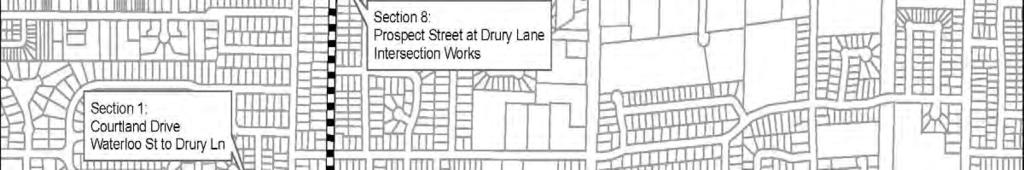
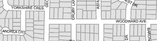
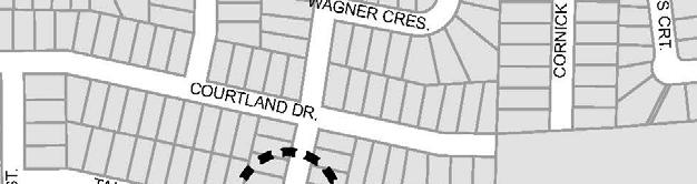
7 Courtland Drive Drury Lane to Waterloo Street Page 7 of 45 02/22/16
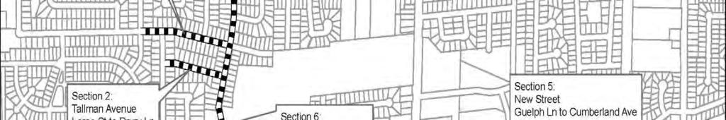
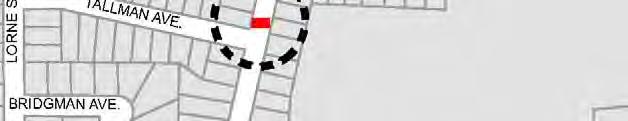
8 Tallman Avenue Lorne Street to Drury Lane Page 8 of 45 02/22/16
9 Road Section 1: Courtland Drive Drury Lane to Waterloo Street Road Section 2: Tll Tallman Avenue Drury Lane to Lorne Street t Scope: Full depth road reconstruction including new sidewalks with the addition of curb and gutter. Cathodic Protection of Watermain on Tallman Avenue (expose ex. WM via vacuum excavation and place anodes every +/- 6 metres) Tentative schedule: May to July 2016 Road closure in effect, with local access maintained. Page 9 of 45 02/22/16


10 Courtland Drive and Tallman Avenue Cross-section and Proposed Lane Configuration Page 10 of 45 02/22/16
11 Stinson Avenue New Street to south end Page 11 of 45 02/22/16
12 Road Section 3: Stinson Avenue New Street to south end Scope: Full depth road reconstruction including new sidewalks with the addition of curb and gutter. Watermain replacement (full length). Tentative Schedule: July to September Road closure in effect, with local access maintained. Page 12 of 45 02/22/16


13 Stinson Avenue Cross-section and Proposed Lane Configuration Page 13 of 45 02/22/16
14 New Street Martha Street to west of Guelph Line Page 14 of 45 02/22/16
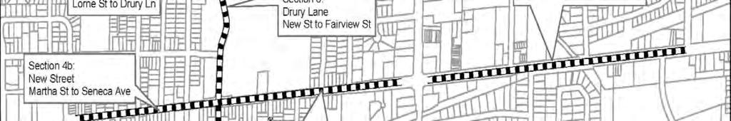
15 Road Section 4: New Street Martha Street to west of Guelph Scope: Full depth, full width asphalt replacement. Curb and sidewalk replacement as needed. Lane configuration will be adjusted to provide on road cycling facilities as per previously approved Report TS (Regular meeting of Council June 30, 2014). The existing width of the roadway will remain the same (refer to next slide). Watermain replacement (full length) and Wastewater Main replacement and rehabilitation (partial Length). Tentative Schedule: Seneca Ave to Guelph Line March 21 to June 3, 2016 Martha St to Seneca Ave May 9 to September 3, 2016 Road closure in effect, with local access maintained. Page 15 of 45 02/22/16
16 New Street Martha Street to west of Guelph Cross-section section and Proposed Lane Configuration Page 16 of 45 02/22/16
17 New Street East of Guelph Line to Cumberland Avenue Page 17 of 45 02/22/16
18 Road Section 5: New Street East of Guelph Line to Cumberland Avenue Scope: Asphalt resurfacing. Curb and sidewalk replacement as needed. The existing width of the roadway will remain the same. Lane widths will be adjusted to provide on road bicycle facilities (refer to next slide). The width of the road will remain the same. Watermain replacement (full length). Tentative Schedule: February to June 2017 Isolated lane closure in effect, with through access maintained (expect delays). Page 18 of 45 02/22/16
19 New Street Guelph Line to Cumberland Avenue Cross-section and Proposed Lane Configuration Page 19 of 45 02/22/16
20 New Street Martha Street to west of Cumberland Avenue Enhanced Cycling Infrastructure Options Development and Infrastructure Committee (meeting of February 17, 2016) has made the following recommendation to Council: Direct the Director of Capital Works to report back to the Development and Infrastructure Committee on March 22 regarding enhanced cycling infrastructure options on New Street as discussed at the meeting on February 17, 2016 including separated cycle lanes, cycling tracks, use of the boulevard, and widening the road. To respond to this staff direction, a public meeting will be held on March 9, 2016, at which options will be presented for separated cycle lanes, cycling tracks, use of the boulevard, and widening the road. Notification of this meeting will be provided during the week of February 29, Page 20 of 45 02/22/16
21 Drury Lane New Street to Fairview Street Page 21 of 45 02/22/16
22 Road Section 6: Drury Lane New Street to Fairview Street (Excludes intersection at Prospect Street) Scope: Full width asphalt milling and replacement (50mm depth). Curb and sidewalk replacement as needed. Base asphalt repair as needed. Road width and lane markings will remain the same as existing. Cathodic Protection of Watermain (expose ex. WM via vacuum excavation and place anodes every +/- 6 metres) Tentative Schedule: July to September 2017 Page 22 of 45 02/22/16
23 Drury Lane Fairview ie Street to north end Page 23 of 45 02/22/16
24 Drury Lane Fairview Street to north end east boulevard Page 24 of 45 02/22/16
25 Road Section 7: Drury Lane Fairview Street to north end Scope: Full depth road reconstruction including curbing and sidewalks. Urbanization of roadway including curbing and boulevard enhancements. Watermain replacement (full length). Tentative e Schedule: e September to November 2016 Road closure in effect, with local access maintained. Page 25 of 45 02/22/16
26 Drury Lane Fairview Street to north end Cross-section and Proposed Lane Configuration Page 26 of 45 02/22/16
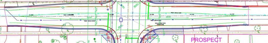
27 Drury Lane at Prospect Street Intersection Improvements Page 27 of 45 02/22/16


28 New Street at Drury Lane Construction Plan Page 28 of 45 02/22/16
29 Road Section 8: Drury Lane at Prospect Street Intersection Improvements Scope: Full depth road widening including curbing and sidewalks. Replacement of existing asphalt roadway. New traffic signal. Watermain replacement approximately 50m in each direction and Wastewater Main replacement on Prospect Street from Joyce Street to Ashley Ave. Tentative Schedule: July to September 2017 Road closure in effect, with local access maintained. Page 29 of 45 02/22/16


30 Drury Lane Proposed traffic control measures Page 30 of 45 02/22/16

31 Road Closures New Street Seneca Ave to Guelph Line CLOSED LOCAL TRAFFIC ONLY March to June 2016 New Street Martha St to Seneca Ave CLOSED LOCAL TRAFFIC ONLY May to September 2016 Drury Lane at Prospect Street - Intersection CLOSED LOCAL TRAFFIC ONLY July to September 2017 Courtland Dr, Tallman Avenue, Stinson Avenue and Drury Lane north of Fairview CLOSED LOCAL TRAFFIC ONLY Various Dates, 2016 Page 31 of 45 02/22/16
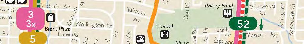
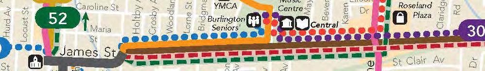
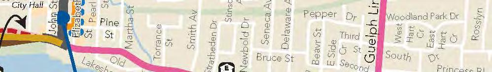
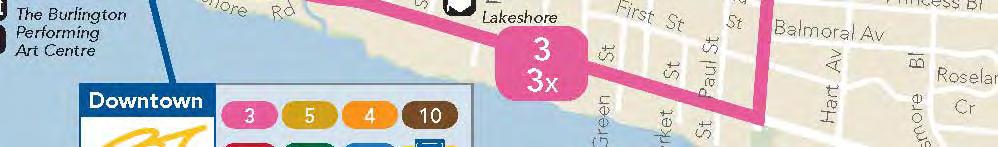
32 Burlington Transit st Route Map Page 32 of 45 02/22/16
33 Burlington Transit Detour Route Map Page 33 of 45 02/22/16
34 Burlington Transit Detour Route Map Page 34 of 45 02/22/16
35 Burlington Transit Detour Route Map Page 35 of 45 02/22/16
36 Burlington Transit Detour Route Map Page 36 of 45 02/22/16
37 Construction ti Issues a) Garbage pick up b) Trees c) On street parking and access d) EMS and Fire e) Access to your home f) Mud and dust g) Water - shut offs h) Vibration i) Lawn Irrigation Systems j) Special Events (refer to next slide) Page 37 of 45 02/22/16
38 Special Events Page 38 of 45 02/22/16


 Page 39 of 45")
39 Communications Keep up to date on the project by: Visiting project webpage Project updates by ad mail Sign up for notifications Contact project team (attached) Page 39 of 45 02/22/16


40 Comments Tk Take a project tif information package: Fill out comments form here or submit later Project team contacts provided in handout Page 40 of 45 02/22/16
41 Project Team Contacts City of Burlington Councillor Marianne Meed Ward Ext Councillor Jack Dennison Ext Bob Jurk, Senior Project Manager Ext Halton Region Rick Ranalli, Project Manager Ext Page 41 of 45 02/22/16
42 Links City of Burlington ca/ Halton Region halton Project Website New and Lane.aspasp Councillor Meed Ward Page 42 of 45 02/22/16
43 New Street and Drury Lane Area Various Streets Rehabilitation Comment Sheet Submitted By: Phone: Page 43 of 45 02/22/16
44 2b. Project Schedule Please return comment sheet by: Leave with us at this meeting to: Mail to: Bob Jurk Burlington City Hall 426 Brant Street Burlington, ON L7R 3Z6 Page 44 of 45 02/22/16


45 Thank you for attending. 2 Feb 2016 Page 45 of 45 02/22/16
Project Update #2. Cedar Springs Road Minor Reconstruction and Culvert Replacement (Britannia Road to Kilbride St)
") Project Update #2 Cedar Springs Road Minor Reconstruction and Culvert Replacement (Britannia Road to Kilbride St) Contract No. CW 18-16 File 570.02-867 The City of Burlington has awarded the above-mentioned
Project Update #2 Cedar Springs Road Minor Reconstruction and Culvert Replacement (Britannia Road to Kilbride St) Contract No. CW 18-16 File 570.02-867 The City of Burlington has awarded the above-mentioned
Public Works and Infrastructure Committee. General Manager, Transportation Services
 STAFF REPORT ACTION REQUIRED Extending the Bay Street Bicycle Lanes Date: May 16, 2013 To: From: Public Works and Infrastructure Committee General Manager, Transportation Services Wards: Toronto Centre
Building Great Neighbourhoods BELLEVUE AND VIRGINIA PARK
 Building Great Neighbourhoods BELLEVUE AND VIRGINIA PARK This is Meeting 2 Unfortunately, some residents in Bellevue and Virginia Park received the wrong information for this public open house (Meeting
City of Madison, East Johnson Street North Baldwin Street to First Street Local Street Dane County
 City of Madison, East Johnson Street North Baldwin Street to First Street Local Street Dane County Public Involvement Meeting Thursday, April 28, 2016 6 to 8 P.M. Lapham Elementary School 1045 E. Dayton
CITY OF VAUGHAN EXTRACT FROM COUNCIL MEETING MINUTES OF OCTOBER 30, 2012
 CITY OF VAUGHAN EXTRACT FROM COUNCIL MEETING MINUTES OF OCTOBER 30, 2012 Item 31, Report No. 39, of the Committee of the Whole, which was adopted without amendment by the Council of the City of Vaughan
Building Great Neighbourhoods BONNIE DOON
 Building Great Neighbourhoods BONNIE DOON We Are Here Today To Explain the Neighbourhood Renewal Process Show you the Westwood Preliminary Design Ask for local knowledge Highlight the Local Improvement
122 Avenue: 107 Street to Fort Road
 : 107 Street to Fort Road November 24, 2015 4:30 8:00 p.m. Meeting Purpose Summarize project work completed to date Share results of public input from Phase 1 Share the draft concept plan and proposed
Building Great Neighbourhoods STRATHEARN
 Building Great Neighbourhoods STRATHEARN Public Involvement Community League Meeting #1: October 5, 2015 Public Meeting #2: March 15, 2016 Public Meeting #3: January 17, 2017 Building Great Neighbourhoods
Building Great Neighbourhoods QUEEN ALEXANDRA
 Building Great Neighbourhoods QUEEN ALEXANDRA We are here today to Explain how the City is investing in improving your neighbourhood and how your neighbourhood will be improved to meet current City standards.
Thursday, May 18, p.m. Kortright Hills Public School Library, 23 Ptarmigan Drive, Guelph
 Teal Drive to Niska Road Open house information package Thursday, May 18, 2017 5 8 p.m. Kortright Hills Public School Library, 23 Ptarmigan Drive, Guelph If you comments, please fill it out the comment
DATE OF MEETING: Wednesday, February 8, Council Chambers, Level 2, City Hall at 6:30 p.m. (Public)
") Bold text indicates different from circulated agenda material COMMITTEE REPORT NO. 02-12 OF DATE OF MEETING: Wednesday, February 8, 2012 PLACE OF MEETING: MEMBERS PRESENT: STAFF PRESENT: Council Chambers,
Bold text indicates different from circulated agenda material COMMITTEE REPORT NO. 02-12 OF DATE OF MEETING: Wednesday, February 8, 2012 PLACE OF MEETING: MEMBERS PRESENT: STAFF PRESENT: Council Chambers,
Pavement Rehabilitation & Buffered Bike Lane
 Pembina Highway from Grant Avenue to Osborne Street Pavement Rehabilitation & Buffered Bike Lane Welcome April 21, 2016 Please complete and submit a comment sheet prior to leaving or complete it online
Construction Staging Area Vaughan Road
 REPORT FOR ACTION Construction Staging Area - 109 Vaughan Road Date: May 25, 2017 To: Toronto and East York Community Council From: Acting Director, Transportation Services, Toronto and East York District
Road Alterations - Wellington Street East, Church Street, and Front Street Intersection
 REPORT FOR ACTION Road Alterations - Wellington Street, Church Street, and Front Street Intersection Date: November 1, 2016 To: Toronto and York Community Council From: Director, Public Realm Section,
City of Madison, East Johnson Street North Baldwin Street to First Street Local Street Dane County
 City of Madison, East Johnson Street North Baldwin Street to First Street Local Street Dane County Public Involvement Meeting Thursday, November 10, 2016 5:30 to 7 P.M. Festival Foods 810 E. Washington
Pre-Construction Meeting
 Pre-Construction Meeting Wednesday, March 21 Drop-in from 5 9pm Please visit displays for project information, talk to staff, and ask questions! Edmonton.ca/SouthsideBikeRoutes Objectives & Project Scope
U.S. HIGHWAY 50 IMPROVEMENT PROJECT
 U.S. HIGHWAY 50 IMPROVEMENT PROJECT in the City of South Lake Tahoe Project Purpose and Need Planned Improvements Project Cost and Delivery Schedule Proposed Construction Staging Project Partners: HIGHWAY
MILEGROUND - AIRPORT ROAD. Fall 2018/ Spring Fall 2020 TBD. US 119 Monongalia County HOW WILL TRAFFIC CONTROL BE HANDLED: KNOW BEFORE YOU GO
 MILEGROUD - AIRPORT ROAD US 119 Monongalia County The Mileground - Airport Road project on US 119 involves upgrading the three-lane facility to a five-lane facility to help eliminate congestion and improve
Major Bike Routes 102 Avenue Workshop April 21, 2015
 Major Bike Routes 102 Avenue Workshop April 21, 2015 Our Purpose Today Provide context on how Major Bike Routes fit into Edmonton s future Share information on what we heard in our last phase, and how
Highway 56 Traffic Study Rymal Road to Cemetery Road
 January 31, 2018 6:00 pm 8:00 pm Highway 56 Traffic Study Rymal Road to Cemetery Road City of Hamilton Public Meeting 2 2 Purpose of Public Meeting To review and obtain public input and comments on the
83 AVENUE PRE-CONSTRUCTION MEETING
 83 AVENUE PRE-CONSTRUCTION MEETING April 6, 2017 5-8PM Please visit displays for project information Talk to staff, ask questions, visit website at: www.edmonton.ca/bike83avenue Pre-Construction Meeting
Traffic Calming St. Clarens Avenue between Brandon Avenue and Davenport Road
 STAFF REPT ACTION REQUIRED Traffic Calming St. Clarens Avenue between Brandon Avenue and Davenport Road Date: February 2, 2012 To: From: Wards: Reference Number: Etobicoke York Community Council Acting
Hennepin Avenue Reconstruction Washington Avenue to 12 th Street
 CITY OF MINNEAPOLIS Hennepin Avenue Reconstruction Washington Avenue to 12 th Street April 2016 1 Upcoming Opportunities Public Meeting #2 April 25, 2016 Minneapolis Central Library Doty Board Room Repeat
Fleur Drive Reconstruction
 Fleur Drive Reconstruction October 29, 2018 1 Agenda: Fleur Drive Reconstruction Project Scope & Cost Overview Fleur Drive Cross Section Elements - Travel Lane Widths - Sidewalk Widths - Parkway Widths
Tonight is for you. Learn everything you can. Share all your ideas.
 Strathcona Neighbourhood Renewal Draft Concept Design Tonight is for you. Learn everything you can. Share all your ideas. What is Neighbourhood Renewal? Creating a design with you for your neighbourhood.
APPENDIX L: COST ESTIMATING TOOLS
 APPENDIX L: COST ESTIMATING TOOLS Rural Arterial From LRE MOT * Mobilization * Subtotal Scope Contingency (25%) Total PE Design (15%) CEI (15%) Total Project ** New (2-Lane Roadway) with 5' Paved Shoulders
SR 2108-A12 Forbes Avenue Betterment. March 1, 2018
 SR 2108-A12 Forbes Avenue Betterment March 1, 2018 Introductions Project Team PENNDOT Cheryl Moon-Sirianni, PE; District Executive Jason Zang, P.E.; Acting Assistant District Executive-Construction John
Traffic Calming Policy
 Page 22 of Report TS-1-13 Development and Infrastructure Division Transportation Services Department Approved by: City Council on February 19, 2013 Report Number: TS-1-13 Effective: February 20, 2013 Amended:
Brooklyn Boulevard (County Road 152) Reconstruction Project Phase I. OPEN HOUSE June 20, 2017
 Reconstruction Project Phase I. OPEN HOUSE June 20, 2017") Brooklyn Boulevard (County Road 152) Reconstruction Project Phase I OPEN HOUSE June 20, 2017 Brooklyn Boulevard (County Road 152) Phase I Project Partners Project Lead Other Project Partners include Brooklyn
Brooklyn Boulevard (County Road 152) Reconstruction Project Phase I OPEN HOUSE June 20, 2017 Brooklyn Boulevard (County Road 152) Phase I Project Partners Project Lead Other Project Partners include Brooklyn
Cycling Network Plan Implementation in Thorncliffe Park and Flemingdon Park
 PW28.13 REPORT FOR ACTION Cycling Network Plan Implementation in Thorncliffe Park and Flemingdon Park Date: March 26, 2018 To: Public Works and Infrastructure Committee From: General Manager, Transportation
CITY OF WOODINVILLE ONGOING CAPITAL IMPROVEMENT PROJECT UPDATES
 CITY OF WOODINVILLE ONGOING CAPITAL IMPROVEMENT PROJECT UPDATES PROJECT LOCATION MAP (1) DEYOUNG PARK IMPROVEMENTS Project Description - DeYoung Park Improvements include treehouse deck, play area, new
AMERICANS WITH DISABILITIES ACT TRANSITION PLAN LEON COUNTY FOR CURB RAMPS AND SIDEWALKS DEPARTMENT OF PUBLIC WORKS. 1 P age
 AMERICANS WITH DISABILITIES ACT TRANSITION PLAN FOR CURB RAMPS AND SIDEWALKS 2015 LEON COUNTY DEPARTMENT OF PUBLIC WORKS 1 P age INTRODUCTION The goal of the Americans with Disabilities Act (ADA) Transition
Americans with Disabilities Act Transition Plan for Public Right-of-Way Improvements
 Americans with Disabilities Act Transition Plan for Public Right-of-Way Improvements Prepared by: Public Works Department Engineering Division October 2015 Table of Contents Section I Introduction.. 3
Welcome. If you have any questions or comments on the project, please contact:
 Welcome This drop-in public open house is intended to provide information about the Bay Street bike lanes project. This project proposes a dedicated cycling facility along Bay Street between Aberdeen Avenue
Kalamazoo County Weekly Project Updates from the Cities of Portage, Kalamazoo and the Kalamazoo County Road Commission
 FOR IMMEDIATE RELEASE Date: October 31, 2014 Kalamazoo County Weekly Project Updates from the Cities of Portage, Kalamazoo and the Kalamazoo County Road Commission Kalamazoo, MI- In a collaborative effort
Building Great Neighbourhoods LANSDOWNE
 Building Great Neighbourhoods LANSDOWNE We are here today to Explain how the City is investing in improving your neighbourhood and how your neighbourhood will be improved to meet current City standards.
VIII. Project Prioritization & Implementation
 Transportation Plan 2030 July 2006 VIII. Project Prioritization & Implementation Public Transit Service Investigation into the development of a demand responsive service route system through a process
City of Sammamish. Welcome. Issaquah-Fall City Road Improvements Project Phase I Design: 242nd Avenue SE to Klahanie Drive SE
 Welcome Welcome to the third community meeting for the Issaquah-Fall City Road Improvements Project. AGENDA 6:00 p.m. Welcome and sign-in 6:10 p.m. Presentation 6:50 p.m. Open house Learn about the roadway
APPENDIX 2 LAKESHORE ROAD TRANSPORTATION REVIEW STUDY EXECUTIVE SUMMARY
 APPENDIX 2 LAKESHORE ROAD TRANSPORTATION REVIEW STUDY EXECUTIVE SUMMARY Appendix 2 City of Mississauga Lakeshore Road FINAL REPORT Transportation Review Study December 2010 EXECUTIVE SUMMARY Study Purpose
Bike Routes Assessment: 95 Ave, 106 St & 40 Ave. Replace with appropriate image in View > Master.
 Bike Routes Assessment: 95 Ave, 106 St & 40 Ave Replace with appropriate image in View > Master. Transportation Committee October 15, 2014 City Council Direction What we are trying to achieve The Way Ahead:
City of Beverly Hills North Santa Monica Blvd Reconstruction. Community Meeting Presentation September 30 and October 1, 2015
 City of Beverly Hills North Santa Monica Blvd Reconstruction Community Meeting Presentation September 30 and October 1, 2015 1 Project Description Complete reconstruction of boulevard (pavement, curbs,
STONY PLAIN ROAD STREETSCAPE
 Jasper Place Revitalization Strategy: Vision The people involved in the Jasper Place Revitalization Strategy envision: Goal 1: Feeling safe in our community Create a community where feeling safe is common--where
MEMORANDUM. Earl Haugen and UND Transportation and Traffic Coordination Committee
 SRF No. 7766 MEMORANDUM TO: FROM: Earl Haugen and UND Transportation and Traffic Coordination Committee Rick Lane, P.E. DATE: November 26, 2013 SUBJECT: UNIVERSITY AVE REVIEW Our review of the University
NUMBER PROJECT TITLE ESTIMATED COST
 NUMBER PROJECT TITLE ESTIMATED COST PROJECT CATEGORY DESCRIPTION TBD= To be determined 1 Art in Pedestrian Underpass $70,000 Culture and Recreation A public art mural in accordance with the Public Art
CITY OF SOUTH DAYTONA
 CITY OF SOUTH DAYTONA FIVE YEAR WORK PLAN for HALF-CENT SALES TAX FY 2020-2025 Table of Contents Executive Summary Purpose of the Work Program... 3 Project List Magnolia Avenue North Roadway, Drainage
CITY OF HAMILTON PLANNING AND ECONOMIC DEVELOPMENT DEPARTMENT Transportation Planning and Parking Division
 CITY OF HAMILTON PLANNING AND ECONOMIC DEVELOPMENT DEPARTMENT Transportation Planning and Parking Division TO: Chair and Members Public Works Committee COMMITTEE DATE: June 18, 2018 SUBJECT/REPORT NO:
Cyclists and Bikeways: What s your match? A guide to bikeway options for a variety of cyclists
 Cyclists and Bikeways: What s your match? guide to bikeway options for a variety of cyclists The workshop and this resource were made possible by funding from the Province of Ontario via the Ministry of
Spring/Summer Traffic and Construction Technical Briefing
 Spring/Summer Traffic and Construction Technical Briefing 1 1. Introduction 2. Infrastructure Investments 3. Impacts to Mobility 4. Transit Operations 5. Mitigation Measures 6. Wrap-Up Overview 2 Infrastructure
CLOSED. The draft concept design has been broken down into 5 categories for the purpose of this survey:
 Old Strathcona s neighbourhood renewal process is now at the draft concept design phase. Over the last several months, the city has been gathering local knowledge and resident input that has been used
West Capitol Avenue Road Rehabilitation and Safety Enhancement Project
 West Capitol Avenue Road Rehabilitation and Safety Enhancement Project Stakeholder Focus Group Meeting #2 Tuesday, August 28, 2018 7:00 8:00 a.m. West Sacramento City Hall 1110 West Capitol Avenue, West
Water Street Promenade. Engineering and Design Services. Public Information Meeting No. 2. Education / Infrastructure / Innovation. Maplewood Avenue &
 Public Information Meeting No. 2 Water Street Promenade Maplewood Avenue & Engineering and Design Services Adjacent Areas July 16,2014Portsmouth, NH May 10, 2016 Education / Infrastructure / Innovation
Mark Malone, P.E. SD DOT
 Mark Malone, P.E. SD DOT SD10 Grading & Surfacing From 8 th Ave W to 8 th Ave E 1 mile plus transition lengths Complete Urban Reconstruction Grading, C&G, Storm Sewer, Sidewalk, Concrete Surfacing Railroad
PROJECT FACT SHEET May 25, 2018
 SITE CHALLENGES & PROJECT BACKGROUND In 2014, the City of Aspen identified the Castle Creek Bridge and Hallam Street corridor as a deficient link in Aspen s bicycle and pedestrian network. Safe and efficient
Welcome! Sherbrooke Neighbourhood Renewal Open House. Sherbrooke Open House February 3, Capital Construction
 Welcome! Sherbrooke Neighbourhood Renewal Open House Overview of the Neighbourhood Renewal Program Presented By: Annie Duong, P.Eng. Current Neighbourhood Roadway Infrastructure Neighbourhoods in Edmonton:
CLOSED. Highlights of the Final Concept Design:
 The final Concept Design is the result of many months of listening, learning, creating, balancing, and understanding different needs and viewpoints, as well as incorporating technical requirements and
SR 2108-A12/SR 2308-A02 Forbes Avenue Betterment and SR 2108-A13 Forbes Avenue Corridor Improvements. July 17, 2017
 SR 2108-A12/SR 2308-A02 Forbes Avenue Betterment and SR 2108-A13 Forbes Avenue Corridor Improvements July 17, 2017 Agenda Welcome Ralph Horgan, CMU Overview of Projects Feedback and Proposed Improvements
Water Street Promenade Engineering and Design Services
 Preliminary Design Presentation Parking & Traffic Safety Committee Water Street Promenade Engineering and Design Services July 16,2014 November 3, 2016 Education / Infrastructure / Innovation 1 Project
Scarlett Road Bridge & Road Improvements Lambton Park Community School - Gymnasium Tuesday November 28 th, 2017
 Scarlett Road Bridge & Road Improvements Lambton Park Community School - Gymnasium Tuesday November 28 th, 2017 PROJECT LOCATION 2 SCARLETT ROAD BRIDGE Constructed in 1912, the bridge carries 4 active
UPDATES 11/14/2018: 10/25/2018: CLOSED 10/22/2018: 10/12/2018: 10/05/2018: 09/27/2018:
 Veterans Boulevard (formerly Boundary Road) This two-year construction project will widen and pave all of Veterans Boulevard. In 2017, the first portion of the road from Highway 16A to 44 Avenue was completed.
Improving Cyclist Safety at the Dundas Street West and Sterling Road Intersection
 STAFF REPORT ACTION REQUIRED Improving Cyclist Safety at the Dundas Street West and Sterling Road Intersection Date: August 17, 2012 To: From: Wards: Reference Number: Public Works and Infrastructure Committee
Cincinnati Dayton Rd Widening
 Cincinnati Dayton Rd Widening Project Overview Widening of Cincinnati Dayton Rd to four lanes - providing a center turn lane and an additional northbound lane Realignment of Station Rd Widening of bridge
WELCOME Public Information Centre
 WELCOME Public Information Centre Fernforest Drive Brampton Soccer Centre Community Room #2 Tuesday January 19, 2016 6:30 p.m.to 9:00 p.m. Please sign in Neighbourhood Traffic Calming Guide Background
BAYVIEW DRIVE & BIG BAY POINT ROAD
 BAYVIEW DRIVE & BIG BAY POINT ROAD City of Barrie DRAFT FINAL prepared by: C.C. Tatham & Associates Ltd. 41 King Street, Unit 4 Barrie, ON L4N 6B5 Tel: (705) 733-9037 Fax: (705) 733-1520 info@cctatham.com
Commerce Street Complete Street Project from Good Latimer Expressway to Exposition Avenue
 Commerce Street Complete Street Project from Good Latimer Expressway to Exposition Avenue T A N Y A B R O O K S A S S I S T A N T D I R E C T O R M O B I L I T Y P L A N N I N G M O B I L I T Y A N D S
AGENDA REQUEST. Unfinished Business BY Neighborhood and Development Services. November 1, 2010 SUBJECT:
 AGENDA REQUEST AGENDA HEADING: Unfinished Business BY Neighborhood and Development Services Originating Department COMMISSION MEETING DATE: November 1, 2010 Timothy Litchet Department Head AGENDA ITEM
Harbord Street and Hoskin Avenue Bicycle Lane Upgrades
 STAFF REPORT ACTION REQUIRED and Bicycle Lane Upgrades Date: April 22, 2014 To: From: Wards: Reference Number: Public Works and Infrastructure Committee General Manager, Transportation Services 19 and
US 301 Resurfacing, Restoration, and Rehabilitation
 US 301 Resurfacing, Restoration, and Rehabilitation From Pond Ave to North of Pioneer Museum Rd/Long Ave Pasco County, FL Work Program Item No. 429075-2 Project Overview Project Location: POND AVE WHITEHOUSE
RESOLUTION NO ?? A RESOLUTION OF THE CITY OF NEPTUNE BEACH ADOPTING A COMPLETE STREETS POLICY
 RESOLUTION NO. 2018-?? A RESOLUTION OF THE CITY OF NEPTUNE BEACH ADOPTING A COMPLETE STREETS POLICY WHEREAS, safe, convenient, and accessible transportation for all users is a priority of the City of Neptune
Bay to Bay Boulevard Complete Streets Project
 Bay to Bay Boulevard Complete Streets Project Dale Mabry Highway to Bayshore Boulevard February 08, 2018 Photo Source: Tampa Bay Times Alessandra Da Pra Meeting Format Introduction Resurfacing Information
Southcote Road Improvements Class Environmental Assessment Study
 1 Southcote Road Improvements Class Environmental Assessment Study Public Information Centre #1 May 24, 2018 Study Area 2 3 Welcome The Ancaster Transportation Master Plan (2011) outlined a long range
PROJECT FACT SHEET March 21, 2018
 SITE CHALLENGES & PROJECT BACKGROUND In 2014, the City of Aspen identified the Castle Creek Bridge and Hallam Street corridor as a deficient link in Aspen s bicycle and pedestrian network. Safe and efficient
INGHAM COUNTY ROAD DEPARTMENT AUSTIN E. CAVANAUGH ADMINISTRATION BUILDING 301 Bush Street, P.O. Box 38, Mason, MI
 INGHAM COUNTY ROAD DEPARTMENT AUSTIN E. CAVANAUGH ADMINISTRATION BUILDING 301 Bush Street, P.O. Box 38, Mason, MI 48854-0038 March 27, 2018 William M. Conklin, P.E. Managing Director FOR IMMEDIATE RELEASE:
CTH M HIGHWAY PROJECT CTH Q to STH 113
 CTH M HIGHWAY PROJECT CTH Q to STH 113 PUBLIC INFORMATIONAL MEETING #3 Wednesday, May 25, 2005 Town of Westport Administration Building 5387 Mary Lake Road 6:00 p.m. to 8:00 p.m. PUBLIC INFORMATIONAL MEETING
Citizen Advisory Group Meeting #8 May 5, Welcome. Today s meeting will focus on: Land Use & Transportation CHARLOTTEPLANNING.
 Citizen Advisory Group Meeting #8 May 5, 2010 Welcome. Today s meeting will focus on: Land Use & Transportation CHARLOTTEPLANNING.ORG Meeting Agenda Handouts: o Meeting Agenda o Summary of East Seventh
May 10, 2013 Meredith Cruz, (561) Palm Beach County Traffic Report May 10 through May 17, 2013
 Palm Beach County Traffic Report May 10 through May 17, 2013") May 10, 2013 Meredith Cruz, (561) 641-6440 mcruz@corradino.com Palm Beach County Traffic Report May 10 through May 17, 2013 Palm Beach County Palm Beach County traffic will be affected this week by ongoing
May 10, 2013 Meredith Cruz, (561) 641-6440 mcruz@corradino.com Palm Beach County Traffic Report May 10 through May 17, 2013 Palm Beach County Palm Beach County traffic will be affected this week by ongoing
Lake Waterford Community Association Meeting. November 15, 2016
 Lake Waterford Community Association Meeting November 15, 2016 Introduction Staff Introduction Project Overviews - Completed Projects - Pavement Management Program - Pasadena Road Sidewalk Improvements
Chapter 4: Funding and Implementation
 Chapter 4: Funding and Implementation 83 84 Cost Estimating Cost estimating is an iterative process. When a project is in the conceptual stage, preliminary cost estimates are also provided conceptually,
Welcome. 53 Avenue Overpass over Whitemud Drive Rehabilitation. Public Information Session. Wednesday, March 9, :30-8:00 p.m.
 BRIDGE REHABILITATION Welcome 53 Avenue Overpass over Whitemud Drive Rehabilitation Public Information Session Wednesday, March 9, 2016 4:30-8:00 p.m. Tonight you can: Learn about the 53 Avenue Overpass
Thank you for attending
 Improving mobility safety comfort WELCOME Thank you for attending The purpose of this meeting is to: Learn about the project Prioritize potential walking and biking improvements on Snelling Ave Gather
Pine Hills Road Pedestrian/Bicycle Safety Study Board of County Commissioners Work Session
 Pine Hills Road Pedestrian/Bicycle Safety Study Board of County Commissioners Work Session February 20, 2018 Meeting Agenda Study Overview Existing Conditions Access Management Potential Gateway Features
Why invest in the 1 Street S.W. Corridor?
 Why invest in the 1 Street S.W. Corridor? This project is an investment in the Beltline Community and Calgary s economy. It is anticipated that The City s investment along this corridor will help with
Dr. M.L. King, Jr. Street North Complete Streets Resurfacing Opportunities HOUSING, LAND USE, AND TRANSPORTATION COMMITTEE MARCH 22, 2018
 Dr. M.L. King, Jr. Street North Complete Streets Resurfacing Opportunities HOUSING, LAND USE, AND TRANSPORTATION COMMITTEE MARCH 22, 2018 What s Happening The City plans to mill and resurface Dr. M.L.
Saskatchewan Drive Roadway Rehabilitation and Shared-Use Path Widening
 Saskatchewan Drive Roadway Rehabilitation and Shared-Use Path Widening We are here today to present the draft plan for the Saskatchewan Drive Roadway Rehabilitation and Shared-Use Path Widening project
Bicycle Traffic Control Signal - St. Clair Avenue West and Poplar Plains Road
 PW17.11 REPORT FOR ACTION Bicycle Traffic Control Signal - St. Clair Avenue West and Poplar Plains Road Date: November 4, 2016 To: Public Works and Infrastructure Committee From: Acting General Manager,
RZC Appendix 8A Marymoor Subarea Street Requirements
 RZC Appendix 8A Marymoor Subarea Street Requirements For additional design details for Marymoor Subarea infrastructure, refer to the 2017 Marymoor Subarea Infrastructure Planning Report. STREET REQUIREMENTS
ARTINSVILLE ENRY OUNTY REA RANSPORTATION TUDY
 ARTINSVILLE ENRY OUNTY REA RANSPORTATION TUDY DEVELOPED BY THE TRANSPORTATION AND MOBILITY PLANNING DIVISION OF THE VIRGINIA DEPARTMENT OF TRANSPORTATION IN COOPERATION WITH THE U.S. DEPARTMENT OF TRANSPORTATION,
General Plan Circulation Element Update Scoping Meeting April 16, 2014 Santa Ana Senior Center, 424 W. 3rd Street, Santa Ana, CA 92701
 General Plan Circulation Element Update Scoping Meeting April 16, 2014 Santa Ana Senior Center, 424 W. 3rd Street, Santa Ana, CA 92701 Meeting Agenda 1. Purpose of Scoping Meeting 2. Project Overview 3.
Project Update May 2018
 Project Update May 2018 Dakota County, in cooperation with the City of Lakeville, is planning to reconstruct 202 nd Street West (County Road 50) from Holyoke Avenue to Cedar Avenue (County Road 23). 202
2017 Temporary traffic control guidelines for pedestrians. v.2
 2017 Temporary traffic control guidelines for pedestrians v.2 Temporary Traffic Control Guidelines for Pedestrians (2017) The safety and mobility of pedestrians, cyclists and motorists must be considered
Agenda Item # Page # RECOMMENDATION
 TO: FROM: SUBJECT: CHAIR AND MEMBERS CIVIC WORKS COMMITTEE MEETING ON FEBRUARY 2, 2016 JOHN BRAAM, P. ENG. MANAGING DIRECTOR, ENVIRONMENTAL & ENGINEERING SERVICES AND CITY ENGINEER FIELD MARSHAL WOLSELEY
Project Status Update
 Project Status Update : Novato Boulevard, 4th & 3rd Streets, Sir Francis Drake Boulevard (3), and Miller Avenue Major roads projects target the most heavily traveled roads in Marin County for repairs,
TRASBURG RANSPORTATION
 TRASBURG RANSPORTATION LAN DEVELOPED BY THE TRANSPORTATION PLANNING DIVISION OF THE VIRGINIA DEPARTMENT OF TRANSPORTATION IN COOPERATION WITH THE U.S. DEPARTMENT OF TRANSPORTATION, FEDERAL HIGHWAY ADMINISTRATION
CITY OF VAUGHAN EXTRACT FROM COUNCIL MEETING MINUTES OF NOVEMBER 15, 2016
 CITY OF VAUGHAN EXTRACT FROM COUNCIL MEETING MINUTES OF NOVEMBER 15, 2016 Item 6, Report No. 38, of the Committee of the Whole, which was adopted without amendment by the Council of the City of Vaughan
CHAIR AND MEMBERS CIVIC WORKS COMMITTEE MEETING ON JANUARY 10, 2017
 TO: FROM: SUBJECT: CHAIR AND MEMBERS CIVIC WORKS COMMITTEE MEETING ON JANUARY 10, 2017 KELLY SCHERR, P.ENG., MBA, FEC MANAGING DIRECTOR ENVIRONMENTAL & ENGINEERING SERVICES AND CITY ENGINEER QUEENS AVENUE
4 DISRUPTION MANAGEMENT PLAN HIGHWAY 7 RAPIDWAY CONSTRUCTION BETWEEN BAYVIEW AVENUE AND WARDEN AVENUE TOWNS OF MARKHAM AND RICHMOND HILL
 4 DISRUPTION MANAGEMENT PLAN HIGHWAY 7 RAPIDWAY CONSTRUCTION BETWEEN BAYVIEW AVENUE AND WARDEN AVENUE TOWNS OF MARKHAM AND RICHMOND HILL The Transportation Services Committee recommends the adoption of
CYCLING PLAN UPDATE. DIY Workshop FACILITATOR GUIDE
 DIY Workshop FACILITATOR GUIDE CYCLING PLAN UPDATE Prepared as part of the Public and Statekholder Engagement Program for the City of Burlington Cycling Plan Update February 2018 About this Facilitator
5. MODIFICATIONS AT JEANNE D ARC BOULEVARD/REGIONAL ROAD 174 INTERCHANGE INTERSECTION - PUBLIC HEARING COMMITTEE RECOMMENDATION
 5. MODIFICATIONS AT JEANNE D ARC BOULEVARD/REGIONAL ROAD 174 INTERCHANGE INTERSECTION - PUBLIC HEARING COMMITTEE RECOMMENDATION Having held a public hearing, that Council approve the preliminary designs
In station areas, new pedestrian links can increase network connectivity and provide direct access to stations.
 The Last Mile Planning for Pedestrians Planning around stations will put pedestrians first. Making walking to stations safe and easy is important; walking will be a part of every rapid transit Accessible
Fairview and Main Local Streets Improvement Plan
 PIM#2 Summary Report Meeting Format Date & Time: Location: Address: Prepared By: Community Open House August 11, 2016 5:30 p.m. 7:30 p.m. Red Lion Hotel 1800 W. Fairview Avenue, Boise Stephanie Borders,
Overview. Illinois Bike Summit IDOT Complete Streets Policy Presentation. What is a Complete Street? And why build them? And why build them?
 Overview Illinois Bike Summit IDOT Complete Streets Policy Presentation Aren Kriks, P.E. District One Bicycle Coordinator and Bureau of Programming Project Engineer History of Complete Streets IDOT Policy