A JURISDICTIONAL HIGHWAY SYSTEM PLAN FOR WASHINGTON COUNTY
|
|
|
- Conrad Wade
- 5 years ago
- Views:
Transcription
1 PLANNING REPORT NO. 23 (2nd Edition) A JURISDICTIONAL HIGHWAY SYSTEM PLAN FOR WASHINGTON COUNTY SOUTHEASTERN WISCONSIN REGIONAL PLANNING COMMISSION
2 SOUTHEASTERN WISCONSIN REGIONAL PLANNING COMMISSION KENOSHA COUNTY Anita M. Faraone Adelene Greene Robert W. Pitts MILWAUKEE COUNTY William R. Drew, Treasurer Lee Holloway George A. Torres OZAUKEE COUNTY Thomas H. Buestrin, Chairman William E. Johnson Gus W. Wirth, Jr., Secretary WAUKESHA COUNTY James T. Dwyer Anselmo Villarreal Paul G. Vrakas RACINE COUNTY Susan S. Greenfield Mary A. Kacmarcik Michael J. Miklasevich WALWORTH COUNTY Richard A. Hansen, Vice-Chairman Gregory L. Holden Allen L. Morrison WASHINGTON COUNTY John M. Jung Daniel S. Schmidt David L. Stroik SOUTHEASTERN WISCONSIN REGIONAL PLANNING COMMISSION STAFF Philip C. Evenson, AICP... Executive Director Kenneth R. Yunker, PE.... Deputy Director Nancy M. Anderson, AICP... Chief Community Assistance Planner Christopher T. Hiebert.... Chief Transportation Engineer Michael G. Hahn, PE, PH.... Chief Environmental Engineer ElizabethA. Larsen... Business Manager John G. McDougall... Geographic Information Systems Manager John R. Meland.... Chief Economic Development Planner Dr. Donald M. Reed... Chief Biologist Kenneth J. Schlager, PE... Chief Telecommunications Engineer Donald P. Simon, RLS... Chief Planning Illustrator William J. Stauber, AICP... Chief Land Use Planner Special acknowledgment is due Mr. Ryan W. Hoel, PE, SEWRPC Principal Engineer, and Mr. David M. Jolicoeur, PE, former SEWRPC Senior Engineer for their contributions to this report. WASHINGTON COUNTY JURISDICTIONAL HIGHWAY PLANNING COMMITTEE Kenneth M. Pesch...Highway Commissioner, Chairman Washington County Kenneth R. Yunker...Deputy Director, Secretary Southeastern Wisconsin Regional Planning Commission James Bennett...Chairman, Town of Hartford Richard L. Bertram...Chairman, Town of Barton RobertA. Bingen...Chairman, Town of Addison Russell Brandt...President, Village of Slinger John Capelle...Director of Community Development, City of West Bend Kristine Deiss...Mayor, City of West Bend Justin Drew...City Planner, City of Hartford Jerry Gilles...Director of Public Works, Village of Kewaskum Dan Goetz...Chairman, Washington County Transportation Committee Joseph C. Gonnering...Chairman, Town of Trenton Scott M. Henke...Mayor, City of Hartford Dewayne J. Johnson...Director, Southeast Region, Wisconsin Department of Transportation Ellis R. Kahn...Chairman, Town of Kewaskum Thomas Kempinski...President, Village of Germantown Dennis E. Kenealy...Chairman, Town of Erin Dwight McComb...Planning and Program Development Engineer, Federal Highway Administration, U.S. Department of Transportation Paul J. Metz...Chairman, Town of Germantown ScottA. Mittelsteadt...President, Village of Jackson PaulA. Mueller...Administrator, Planning and Parks Department, Washington County Judith Neu...City Engineer, City of West Bend Diane Pederson...President, Village of Richfield Gene Reiter...Citizen Representative, Town of Polk Paul R. Rice...Chairman, Town of West Bend Bill Sackett...President, Village of Newburg Thomas J. Sackett...Chairman, Washington County Board of Supervisors Paul Servais...Chairman, Town of Jackson Gary Schreiber...Chairman, Town of Farmington Scott Weiss...Chairman, Town of Wayne
3 RESOLUTION NO RESOLUTION OF THE SOUTHEASTERN WISCONSIN REGIONAL PLANNING COMMISSION AMENDING THE ADOPTED YEAR 2035 REGIONAL TRANSPORTATION SYSTEM PLAN FOR SOUTHEASTERN WISCONSIN, THE PLAN BEING A PART OF THE MASTER PLAN FOR THE PHYSICAL DEVELOPMENT OF THE REGION CONSISTING OF THE COUNTIES OF KENOSHA, MILWAUKEE, OZAUKEE, RACINE, WALWORTH, WASHINGTON, AND WAUKESHA IN THE STATE OF WISCONSIN (WASHINGTON COUNTY JURISDICTIONAL HIGHWAY SYSTEM PLAN) WHEREAS, in 2006, pursuant to Section of the Wisconsin Statutes, the Southeastern Wisconsin Regional Planning Commission adopted a regional transportation plan as documented in SEWRPC Planning Report No. 49, A Regional Transportation System Plan for Southeastern Wisconsin: 2035; and WHEREAS, at the request of the Washington County Board of Supervisors, the Commission, in cooperation with Washington County, each city, village, and town within Washington County, the Wisconsin Department of Transportation, and the U.S. Department of Transportation-Federal Highway Administration, reviewed and reevaluated the Washington County jurisdictional highway system plan; and WHEREAS, the review and reevaluation was based on a comprehensive study, guided by a Washington County Jurisdictional Highway Planning Committee, which included representatives from Washington County, each city, village, and town within Washington County, the Wisconsin Department of Transportation and the U.S. Department of Transportation-Federal Highway Administration; and WHEREAS, the review and reevaluation of the jurisdictional highway system plan for Washington County is documented in SEWRPC Planning Report No. 23 (Second Edition), A Jurisdictional Highway System Plan for Washington County; and WHEREAS, on the 28 th day of February 2008 the amended year 2035 Washington County jurisdictional highway system plan was unanimously approved by the Washington County Jurisdictional Highway Planning Committee; and WHEREAS, on the 9 th day of December 2008, the amended year 2035 Washington County jurisdictional highway system plan was adopted by the Washington County Board of Supervisors; and WHEREAS, under the provisions of Section (9) of the Wisconsin Statutes, the Regional Planning Commission is authorized and empowered, as the work of making the whole master plan progresses, to amend, extend, or add to the master plan or carry any part or subject matter thereof into greater detail; NOW THEREFORE, BE IT HEREBY RESOLVED: FIRST: That the year 2035 Washington County jurisdictional highway system plan, being an integral component of the adopted regional transportation plan, be and the same hereby is in all respects amended in the manner identified on Map 30, page 64, of the aforereferenced SEWRPC Planning Report No. 23 (Second Edition), A Jurisdictional Highway System Plan for Washington County, published in July 2008, a copy of which is attached hereto and made a part thereof.
4 -2- Resolution No SECOND: That a true, correct, and exact copy of this resolution and the aforereferenced planning report shall be forthwith distributed to the local units of government in Washington County, the Washington County Board of Supervisors, the Wisconsin Department of Transportation, and the Federal Highway Administration. The foregoing resolution, upon motion duly made and seconded, was regularly adopted at the meeting of the Southeastern Wisconsin Regional Planning Commission held on the 4th day of March 2009, the vote being: Ayes 11; Nays 0. ATTEST: David L. Stroik, Chairman Kenneth R. Yunker, Deputy Secretary
5 PLANNING REPORT NUMBER 23 (2 nd Edition) A JURISDICTIONAL HIGHWAY SYSTEM PLAN FOR WASHINGTON COUNTY Prepared by the Southeastern Wisconsin Regional Planning Commission P.O. Box 1607 W239 N1812 Rockwood Drive Waukesha, WI The preparation of this publication was financed in part through planning funds provided by the Wisconsin Department of Transportation and the U.S. Department of Transportation, Federal Highway Administration. July 2008 Inside Region $10.00 Outside Region $20.00
6 (This page intentionally left blank)


7 Washington County Highway Department Commissioner: Kenneth M. Pesch, P.E. To: Washington County Board of Supervisors Southeastern Wisconsin Regional Planning Commission Wisconsin Department of Transportation The Washington County Board of Supervisors in 1975 adopted an initial Washington County jurisdictional highway system plan for the design year That plan was later amended on five occasions. Three of these amendments occurred upon the adoption of the major reevaluations of the regional transportation plan in 1978, 1994, and 1997, which extended the design period of the regional transportation plan and the Washington County jurisdictional highway system plan, first to the year 2000, then to the year 2010, and then to the year The current regional transportation plan was adopted by the Southeastern Wisconsin Regional Planning Commission on June 21, 2006, extending the plan design period to the year The design year 2035 regional transportation plan contains an up-to-date functional arterial street and highway system plan consisting of recommendations concerning the general location, type, capacity, and service levels of the arterial street and highway system. The regional transportation plan, however, did not reevaluate, but rather continues the recommendations of the design year 2020 Washington County jurisdictional highway system plan. In July 2008, Commission staff, under the guidance of the Washington County Jurisdictional Highway Planning Committee, completed the work necessary to review, update, and extend to the year 2035 the Washington County jurisdictional highway system plan. The Washington County Jurisdictional Highway Planning Committee was formed to assist and advise Commission staff in this planning effort, and has representation from the cities, villages, and towns in Washington County, the County, as well as from the Federal and state levels. The Washington County jurisdictional highway system plan provides a review and reevaluation, and recommendations as to which levels and agencies of government should assume responsibility for the construction, operation, and maintenance of each of the various arterial facilities included in the plan to the year The Washington County jurisdictional highway plan also provides a review, as requested by the Washington County Jurisdictional Highway Planning Committee and Washington County local governments, of specific functional improvements arterials to be widened with additional lanes and new arterials recommended in the design year 2035 regional transportation plan. The Washington County jurisdictional highway system plan thus is intended to be a functional, as well as jurisdictional, arterial street and highway system plan for Washington County to the design year The findings and recommendations of this report were considered and unanimously approved by the Washington County Jurisdictional Highway Planning Committee. The new Washington County jurisdictional highway system plan is advisory to the local governments in the County, Washington County itself, and the State of Wisconsin. Plan implementation will depend upon the willingness and ability of the State, county, and local governments to fund and put in place the recommended arterial street and highway improvements and implement recommended jurisdictional changes. With the plan design period extended to the year 2035, the Washington County jurisdictional highway system plan provides Washington County a framework for implementing an integrated highway transportation system which would effectively serve and promote a desirable land use pattern within the County, abate traffic congestion, reduce travel time and costs, and reduce accident exposure. It would also serve to concentrate appropriate resources and capabilities on corresponding areas of need, assuring the most effective use of the total public resources in the provision of highway transportation. The report and plans are hereby respectfully submitted for your careful consideration and, hopefully, adoption. Favorable action on the report and plan is respectfully urged by the Commission staff and by the Washington County Jurisdictional Highway Committee. Very truly yours, Kenneth M. Pesch Chairman, Washington County Jurisdictional Highway Committee 900 Lang Street, West Bend, WI PHONE (262) FAX (262) webhwy@co.washington.wi.us
8 (This page intentionally left blank)
9 ` TABLE OF CONTENTS Page Chapter I INTRODUCTION... 1 Study Organization... 3 Advisory Committee Structure... 3 Study Purpose and Plan Objectives... 3 Scheme of Presentation... 4 Chapter II EXISTING AND PLANNED WASHINGTON COUNTY ARTERIAL STREETAND HIGHWAY SYSTEM... 5 Introduction... 5 Arterial Street and Highway System... 5 Arterial Street and Highway System Jurisdiction... 6 Regional Transportation Plan and Washington County Jurisdictional Highway System Plan... 8 Functional Improvements Completed in Washington County Since Adoption of the First Washington County Jurisdictional Highway System Plan in Current Functional Improvement Recommendations for Washington County.. 9 Potential Functional Improvements to be Addressed during the Washington County Jurisdictional Highway System Plan Review and Update... 9 Consider Alternatives to Address Existing and Future Traffic Congestion Problems on STH 60 through the Village of Jackson Consider the Use of Existing Creek Road as an Arterial between River Road and Trenton Road Rather than Construction of a New Arterial Reconsider the Planned Reserve Right-of-Way Recommendation to Accommodate a Future Improvement along STH 33 and between STH 144 and USH v Page Reconsider the Planned Extension of N. River Road between Creek Road and STH Reconsider the Planned Extension of Division Road between STH 167 and Freistadt Road Consider the Addition of Wildwood Road between the Planned Extension of Schuster Drive and CTH D as a Planned Arterial Consider Cedar Lane between STH 145 and CTH G as an Alternative to the Planned Arterial Route of Rockfield Road between STH 145 and CTH G Consider the Addition of an Extension of Kettle View Drive between STH 28 and USH 45 in the Village and Town of Kewaskum Reconsider the Planned Alternative USH 45 Route Through the Village of Kewaskum Consider the Need for Four Traffic Lanes on 18 th Avenue between Paradise Drive and Decorah Road in the City of West Bend Consider the Need for Four Traffic Lanes on Rusco Drive between CTH P and CTH G in the City and Town of West Bend Consider the Use of CTH C as an Arterial between STH 60 and CTH Z Rather than Scenic Road Consider the Addition of Midland Drive between CTH D and STH 28 as an Arterial in the Town of Wayne Consider the Need for Six Traffic Lanes on USH 41 between the USH 41/45 Split and STH
10 Page Reconsider the Need for the Planned Extension of Kettle View Drive between STH 33 and Schuster Drive Consider the Need to Reserve Right-of-Way for Six Traffic Lanes on USH 45 between the USH 41/45 Split and STH Capacity Improvements Recommended in the Year 2035 Washington County Jurisdictional Highway System Plan Jurisdictional Highway Transfers Completed in Washington County Since Adoption of the First Washington County Jurisdictional Highway System Plan in Current Jurisdictional Transfer Recommendations for Washington County.. 41 Potential Jurisdictional Highway Transfers to be Addressed during the Washington County Jurisdictional Highway System Plan Review and Update Chapter III JURISDICTIONAL CLASSIFICATION CRITERIA Introduction Purpose and Objective of the Criteria Arterial Subclassification State Trunk Arterials County Trunk Arterials Local Trunk Arterials Criteria Trip Service Criteria Land Use Service Criteria Criteria Relating to Operational Characteristics System Continuity Spacing Volume Traffic Mobility Land Access Other Factors State Statutes Governing Jurisdictional Transfers Summary Chapter IV APPLICATION OF JURISDICTIONAL CLASSIFICATION CRITERIA Introduction Trip Service Jurisdictional Classifications Page Land Use Service Jurisdictional Classification Development of the Jurisdictional Highway System Plan Specific Consideration of Jurisdictional Classification of Facilities Identified by the Washington County Jurisdictional Highway Planning Committee Newark Drive and Lighthouse Lane between CTH D and STH Pioneer Road between Slinger Road and USH CTH H between CTH W and USH CTH C between STH 60 and CTH P Historic Trends and Distribution Kettle View Drive between Badger Road and STH 28 and Badger Road between Kettle View Drive and USH CTH W between STH 28 and the Washington County-Fond du Lac County Line CTH X between STH 144 and CTH XX Paradise Drive between 18 th Avenue and USH 45 and 18 th Avenue between CTH NN and Paradise Drive CTH O between STH 83 and the Washington County-Dodge County Line Division Road between STH 145 and CTH Q N. River Road and its Extension between STH 33 and STH Trenton Road and Newark Drive between STH 33 and STH CTH XX between CTH H and the Washington County-Sheboygan County Line STH 144 between USH 41 and STH STH 83 between STH 60 and STH STH 175 between STH 83 and STH CTH K between STH 83 and STH CTH D between STH 144 and USH Changes approved by the Washington County Jurisdictional Highway Planning Committee to the Preliminary Recommended Year 2035 Washington County Jurisdictional Highway System Plan Summary vi
11 Page Chapter V RECOMMENDED WASHINGTON COUNTY JURISDITIONAL HIGHWAY SYSTEM PLAN Introduction Functional Improvement Recommendations for Washington County Recommended Jurisdictional Highway System Plan for Washington County Plan Implementation Local Level Washington County Board of Supervisors City Common Councils, Village Boards, and Town Boards Regional Level Regional Planning Commission State Level Wisconsin Department of Transportation Federal Level U.S. Department of Transportation, Federal Highway Administration Chapter VI SUMMARY AND CONCLUSIONS Introduction Advisory Committee Structure Study Purpose and Plan Objectives Arterial Street and Highway System in Washington County Arterial Street and Highway System Jurisdiction Regional Transportation Plan and Washington County Jurisdictional Highway System Plan Page Functional Improvements Completed in Washington County Since Adoption of the First Washington County Jurisdictional Highway System Plan in Functional Improvements Addressed During the Washington County Jurisdictional Highway System Plan Review and Update Jurisdictional Highway Transfers Completed in Washington County Since Adoption of the First Washington County Jurisdictional Highway System Plan in Jurisdictional Classification Criteria Application of Jurisdictional Classification Criteria Recommended Year 2035 Washington County Jurisdictional Highway System Plan Local Level Washington County Board of Supervisors City Common Councils, Village Boards, and Town Boards Regional Level Regional Planning Commission State Level Wisconsin Department of Transportation Federal Level U.S. Department of Transportation, Federal Highway Administration Conclusions LIST OF TABLES Table Page Chapter II 1 Arterial Street and Highway Mileage by Jurisdiction in Washington County: Arterial Street and Highway Improvement and Expansion Projects Completed in Washington County: Capacity Improvements in Washington County Recommended in the Year 2035 Regional Transportation Plan Jurisdictional Highway System Transfers Completed in Washington County: vii
12 Table Page Chapter III 5 Average Trip Length Criteria for Jurisdictional Classification Average Weekday Traffic Volume Criteria for Jurisdictional Classification Traffic Mobility Criteria for Jurisdictional Classification Summary of Functional Criteria for Jurisdictional Classification of Arterial Streets and Highways in Washington County Chapter IV 9 Comparison of Washington County Street and Highway Mileage Under Existing Year 2005 Conditions and the Preliminary Recommended Year 2035 Washington County Jurisdictional Highway System Chapter V 10 Capacity Improvements in Washington County Recommended in the Final Year 2035 Washington County Jurisdictional Highway System Plan Comparison of Washington County Street and Highway Mileage Under Existing Year 2005 Conditions and the Final Recommended Year 2035 Washington County Jurisdictional Highway System Plan Arterial Street and Highway Mileage by Jurisdiction under the Final Recommended Year 2035 Washington County Jurisdictional Highway System Plan LIST OF FIGURES Figure Page Chapter II 1 Potential Cross-Section for the Planned USH 45 Extension along the Former C & NW Railway Right-of-Way in the Village of Kewaskum Chapter III 2 Relationship between Average Trip Length and Cumulative Arterial Miles on the Washington County Arterial Street and Highway System: Relationship between Average Weekday Vehicle Volume and Cumulative Arterial Miles on the Washington County Arterial Street and Highway System: Map LIST OF MAPS Chapter II Page 1 Existing Arterial Street and Highway System in Washington County: viii
13 Map Page 2 Arterial Street and Highway Projects Completed in Washington County by Improvement Category: Capacity Improvements in Washington County Recommended in the Year 2035 Regional Transportation Plan STH 60 Right-of-Way in the Village of Jackson Existing Year 2005 and Forecast Year 2035 Average Weekday Traffic Volumes on STH 60 in the Village of Jackson Comparison of Existing Year 2004 and Forecast Year 2035 Average Weekday Traffic Volumes to Existing Roadway Design Capacity of STH 33 in Washington County Capacity Improvements Recommended in the Year 2035 Regional Transportation Plan in the West Bend Area City of West Bend Planned Sanitary Sewer Service Area: Alternative Alignments for the Extension of N. River Road between Creek Road and STH 144 in the City of West Bend Area Recommended to be Considered During Preliminary Engineering Capacity Improvements Recommended in the Year 2035 Regional Transportation Plan in the Germantown Area Wildwood Road between the Planned Extension of Schuster Drive and CTH D Rockfield Road between STH 145 and Pleasant View Drive in the Germantown Area Village of Kewaskum Sanitary Sewer Service Area: Capacity Improvements Recommended in the Year 2035 Regional Transportation Plan in the Kewaskum Area Planned Alternative USH 45 Route along the Former C & NW Railway Right-of-Way in the Village of Kewaskum Comparison of Existing Year 2004 and Forecast Year 2035 Average Weekday Traffic Volumes to Existing Roadway Design Capacity on 18 th Avenue in the West Bend Area Comparison of Forecast year 2035 Average Weekday Traffic Volumes to Existing Roadway Design Capacity of Rusco Drive in the West Bend Area Capacity Improvements Recommended in the Year 2035 Regional Transportation Plan in the Eastern Slinger Area Village of Slinger Planned Sanitary Sewer Service Area: Midland Drive between CTH D and STH 28 in the Town of Wayne Comparison of Existing Year 2006 and Forecast Year 2035 Average Weekday Traffic Volumes to Existing Roadway Design Capacity on USH 41 and USH 45 between STH 60 and USH 41/USH 45 Split Capacity Improvements Recommended in the Year 2035 Regional Transportation Plan in the West Bend Area Capacity Improvements Recommended in the Year 2035 Washington County Jurisdictional Highway System Plan Jurisdictional Highway System Transfers Completed in Washington County: Current Jurisdictional Highway System Plan for Washington County: Changes in Jurisdictional Responsibility Recommended Under the Current Washington County Jurisdictional Highway System Plan: Chapter IV 27 Jurisdictional Classification of the Arterial Street and Highway System in Washington County Based on Average Trip Length: ix
14 Map Page 28 Jurisdictional Classification of the Arterial Street and Highway System in Washington County Based on Land Use: Jurisdictional Classification of the Arterial Street and Highway System in Washington County Based on Average Weekday Vehicle Volume: Preliminary Recommended Year 2035 Washington County Jurisdictional Highway System Plan Changes in Jurisdictional Responsibility under the Preliminary Recommended Year 2035 Washington County Jurisdictional Highway System Plan Chapter V 32 Capacity Improvements Recommended in the Final Year 2035 Washington County Jurisdictional Highway System Plan Final Recommended Year 2035 Washington County Jurisdictional Highway System Plan Changes in Jurisdictional Responsibility Under the Final Recommended Year 2035 Washington County Jurisdictional Highway System Plan x
15 Chapter I INTRODUCTION On July 8, 1975, the Washington County Board of Supervisors adopted an initial jurisdictional highway system plan. That plan, with a design year of 1990 and set forth in SEWRPC Planning Report No. 23, A Jurisdictional Highway System Plan for Washington County, was based upon a comprehensive study of the jurisdictional responsibilities for the construction, maintenance, and operation of arterial streets and highways in Washington County. Prepared under the guidance of an Advisory Committee consisting of Federal, State, county, and local officials, the plan was intended to help provide the County, over time, with an integrated highway transportation system that would effectively serve and promote a desirable land use pattern in the County, abate traffic congestion, reduce travel time and costs, and reduce crash exposure. The plan was intended to help concentrate appropriate resources and capabilities on corresponding areas of need, thus assuring the most effective use of public resources in the provision of highway transportation. The initial plan was prepared as a logical sequel to the 1990 seven-county regional transportation system plan. That plan focused on needed functional improvements to the regional arterial street and highway system, but, except for freeways, contained no recommendations as to which levels and agencies of government should assume jurisdictional responsibility for each of the facilities included in the functional plan. Since its initial adoption in 1975, the Washington County jurisdictional highway system plan has been previously amended on five occasions. The first amendment of the original Washington County jurisdictional highway system plan occurred in 1978, upon the adoption by the Regional Planning Commission of the second-generation regional transportation plan. 1 While this second-generation regional transportation plan was adopted by the Regional Planning Commission on June 1, 1978, it was never formally adopted by the Washington County Board of Supervisors. The next amendment of the Washington County jurisdictional highway system plan occurred in This amendment was formally adopted by the Washington County Board of Supervisors on April 17, The Washington County jurisdictional highway system plan was amended again in 1994, upon adoption of the year 2010 third-generation regional transportation plan by the Commission. 3 The regional transportation plan, and attendant amended Washington County jurisdictional highway system plan as of 1994, were endorsed by the Washington County Jurisdictional Highway Planning Committee in 1994 and adopted by the Washington County Board in Another amendment of the Washington County jurisdictional highway system 1 See SEWRPC Planning Report No. 25, A Regional Land Use Plan and a Regional Transportation Plan for Southeastern Wisconsin 2000, Volume One, Inventory Findings, April 1975; and Volume Two, Alternative and Recommended Plans, May See Amendment to the Washington County Jurisdictional Highway System Plan 2000, November See SEWRPC Planning Report No. 41, A Regional Transportation System Plan for Southeastern Wisconsin: 2010, December
16 plan occurred in 1997, upon the extension of the design year 2010 regional transportation plan to the design year 2020, and its adoption by the Commission. 4 The most recent amendment of the Washington County jurisdictional highway system plan occurred in The latest review and re-evaluation of the regional land use and regional transportation plans by the Commission resulted in a fifth-generation design year 2035 regional land use plan, adopted by the Commission on June 21, 2006, and a fifth-generation design year 2035 regional transportation plan, also adopted by the Commission on June 21, In accordance with its advisory role, the Commission certified these plans to the constituent counties, cities, villages, and towns, as well as to certain state and Federal agencies, for endorsement and implementation. The adopted regional transportation plan is set forth in SEWRPC Planning Report No. 49, A Regional Transportation System Plan for Southeastern Wisconsin: 2035, June The regional transportation plan made recommendations regarding five key transportation elements: public transit, bicycle and pedestrian facilities, transportation system management, travel demand management, and arterial street and highways. The public transit element envisions significant improvement and expansion of public transit in Southeastern Wisconsin, including development within the Region of a rapid transit and express transit system, improvement of existing local bus service, and the integration of local bus service with the proposed rapid and express transit services. The bicycle and pedestrian facility element is intended to promote safe accommodation of bicycle and pedestrian travel, and encourage bicycle and pedestrian travel as an alternative to personal vehicle travel. The transportation systems management element includes measures intended to manage and operate existing transportation facilities to their maximum carrying capacity and travel efficiency, including: freeway traffic management, surface arterial street and highway traffic management, and major activity center parking management guidance. The travel demand management element includes measures intended to reduce personal and vehicular travel or to shift such travel to alternative times and routes, allowing for more efficient use of the existing capacity of the transportation system. The arterial street and highway element recommends the improvements needed to address the residual congestion which may not be expected to be alleviated by proposed land use, transportation systems management, travel demand management, bicycle and pedestrian facilities, and public transit. The regional transportation plan thus contains an up-to-date functional arterial street and highway system plan. This functional plan consists of recommendations concerning the general location, type, capacity, and service levels of the arterial street and highway facilities required to serve southeastern Wisconsin and Washington County to the year The regional transportation plan, however, did not reevaluate, but continues the recommendations from the current county jurisdictional highway system plans as to which levels and agencies of government should assume responsibility for the construction, operation, and maintenance of each of the various arterial facilities included in the plan. This Washington County jurisdictional highway system plan update will provide a review and reevaluation, and recommendations as to which level and agency of government should have jurisdictional responsibilities for each segment of arterial street and highway in Washington County. This review is required at this time in order to address changing traffic demands and patterns, to adjust the jurisdictional systems to changes in land use development patterns, and to assure the maintenance of an integrated network of state and county trunk highways as urban development continues within the county. As the second edition of SEWRPC Planning Report No. 23, this document is intended to be reviewed and approved by the Washington County Jurisdictional Highway Planning Committee, by the Highway Committee of the Washington County Board of Supervisors, by the Board itself, and by the Southeastern Wisconsin Regional Planning Commission as the official areawide planning agency for Southeastern Wisconsin. 4 See SEWRPC Planning Report No. 46, A Regional Transportation Plan for Southeastern Wisconsin: 2020, December See Amendment to the Washington County Jurisdictional Highway System Plan 2020, March
17 STUDY ORGANIZATION This jurisdictional highway system planning effort is an update to the current jurisdictional highway system plan and was preceded by an intensive, comprehensive, areawide functional highway planning study as part of the design year 2035 regional transportation plan. The regional transportation plan provides almost all of the necessary basic planning and engineering data, as well as the basic traffic simulation models, essential to the jurisdictional highway system planning effort. Advisory Committee Structure Because any realignment in the jurisdictional highway system would affect the Federal, state, and local units of government concerned in many ways, it is essential to actively involve these units of government in the jurisdictional highway planning process. Such participation has been previously obtained within the county in connection with the original Washington County jurisdictional highway system plan and its subsequent amendments through the Washington County Jurisdictional Highway Planning Committee. That Committee has representation from the cities, villages, and towns in the County, the County, as well as from the Federal and state levels. A Washington County Jurisdictional Highway Planning Committee will, therefore, provide guidance and assistance to the staff during the course of this study. Specifically, this Committee is charged with assisting and advising the study staff on technical methods, procedures, and interpretations; assisting in the assembly and evaluation of planning and engineering data; assisting in the establishment, definition, and review of criteria; appraising alternative plans; and resolving any conflicts which might arise in plan preparations and selection. The Committee is intended to be a working committee and to actively involve the Federal, state, and local officials in the planning process. A complete committee membership list is set forth on the inside front cover of this report. STUDY PURPOSE AND PLAN OBJECTIVES The primary purpose of jurisdictional highway system planning is to group into classes arterial streets and highways that serve similar functions and which, accordingly, should have similar design standards and levels of service. Once this classification process is completed, it is possible to assign jurisdictional responsibility logically for the design, construction, operation, and maintenance of each of the groups to the state, county, and local levels of government. Thus, a county jurisdictional highway system plan indicates which highway facilities should be the primary responsibility of state government, county government, and local government city, village, or town. The Washington County jurisdictional highway system plan is intended to help Washington County: Cope with the growing traffic demands within the County; Adjust the existing jurisdictional highway systems to changes in land use development along their alignment; Maintain an integrated county trunk highway system within the County; Adjust the existing jurisdictional highway system to better serve the major changes in traffic patterns taking place within the County; and Achieve an equitable distribution of arterial street and highway development and maintenance costs and revenues among the various levels and agencies of government concerned. The county jurisdictional highway system plan will also provide a review, as requested, of the functional highway improvements arterials to be widened with additional lanes and new arterials recommended in the regional transportation plan within Washington County. 3
18 SCHEME OF PRESENTATION The findings and recommendations of this updated Washington County jurisdictional highway system planning process are documented in this report. Following this introductory chapter, Chapter II describes the existing arterial street and highway system and jurisdictional highway system in Washington County; reviews the functional improvements of the arterial system and jurisdictional transfers of arterials between the various units of government state, county and local completed over the past 30 years since 1975, the year the original Washington County jurisdictional highway system plan was adopted; and presents the recommendations of the recently completed regional transportation plan with respect to functional highway capacity improvements and jurisdictional transfers. Chapter III describes the jurisdictional classification criteria utilized in this Washington County jurisdictional highway system planning effort, which are intended to provide an objective and rational basis for the assignment of jurisdictional responsibility for the segments of the arterial street and highway system to the levels of government concerned state, county and local. Chapter III also describes the current State Statutes governing the jurisdictional transfer of streets and highways. Chapter IV summarizes the application of the various jurisdictional classification criteria to the Washington County arterial street and highway system that were considered in the formulation of the preliminary and recommended jurisdictional highway system plan, and presents the preliminary recommended new Washington County jurisdictional highway system plan. Chapter V presents the final recommended Washington County jurisdictional highway system plan. Chapter VI summarizes the new Washington County jurisdictional highway system plan. 4
19 Chapter II EXISTING AND PLANNED WASHINGTON COUNTY ARTERIAL STREET AND HIGHWAY SYSTEM INTRODUCTION This chapter describes the existing and planned arterial street and highway system, including the existing and planned jurisdiction of that system, in Washington County. The functional improvements (new arterials and widened arterials) and jurisdictional transfers recommended in the design year 2035 regional transportation plan and the current Washington County jurisdictional highway system plan, are presented along with an evaluation of additional functional improvements and potential jurisdictional transfers identified by the Washington County Jurisdictional Highway Planning Committee for consideration during the preparation of this jurisdictional highway system plan. Based upon that evaluation, recommended changes are identified to the functional improvements in the jurisdictional highway system plan and regional transportation system plan. ARTERIAL STREET AND HIGHWAY SYSTEM Streets and highways may be functionally classified into three categories arterial streets, land access streets, and collector streets based upon the manner in which they function. Arterial streets are defined as streets and highways which are principally intended to provide a high degree of travel mobility, serving the through movement of traffic and providing transportation service between major subareas of an urban area or through the area. Together, the arterial streets should form an integrated, areawide system. Access to abutting property may be a secondary function of some types of arterial streets and highways, but it should always be subordinate to the primary function of traffic movement. Land access streets are defined as streets which are intended to serve primarily as a means of access to abutting properties, principally serving the residential areas of a community. Collector streets are defined as streets which are intended to serve primarily as connectors between the arterial system and the land access street system. In addition to collecting traffic from, and distributing traffic to, the land access streets, the collector streets usually provide the same principal function as land access streets, that of providing access to abutting property. As a result, collector and land access streets are sometimes combined and referred to as nonarterial, or local, streets. The regional transportation plan and Washington County jurisdictional highway system plan address only the arterial street and highway element of the total street and highway system. Arterial streets and highways are the only element of the total street and highway system for which existing and future traffic volume, and the need for 5
20 additional traffic lanes or for a new arterial facility to relieve traffic, is a consideration in facility and system design. The definition of arterials has been determined by an evaluation of four major factors: 1) traffic characteristics traffic volume and type, operating speeds, and average trip length; 2) physical characteristics horizontal and vertical alignment, pavement width, and pavement types; 3) system integration system continuity and facility spacing; and 4) land use service the areawide significance of the land use activities served. Arterial streets generally account for about 30 percent of the mileage of the total street and highway system, and carry about 90 percent of the total average weekday traffic in Southeastern Wisconsin. Arterial streets are generally recommended to be spaced at about one-half mile intervals in high-density areas, one-mile intervals in medium-density areas, two-mile intervals in low-density areas, and intervals of more than two miles in rural areas. To serve travel effectively, and to make efficient use of public resources, the arterial street system should be planned as an integrated system, irrespective of jurisdictional boundaries and jurisdictional responsibilities for streets and highways, with consideration of existing and future traffic volumes, and with traffic capacities fitted to serve those traffic volumes. Together with local governments and the Wisconsin Department of Transportation, the Commission has defined the arterial street and highway system of Washington County and all of Southeastern Wisconsin over the past 40 years. The existing year 2005 arterial street and highway system in Washington County is displayed on Map 1. Over the past 30 years, the mileage of the arterial street and highway system in Washington County increased from 345 miles in 1975, the year the original Washington County jurisdictional highway system plan was adopted, to 427 miles in 2005, an increase of 82 miles, or about 24 percent. ARTERIAL STREET AND HIGHWAY SYSTEM JURISDICTION The jurisdictional classification of the arterial street and highway system identifies the level of government State, county, or local having responsibility for the design, construction, maintenance, and operation of each segment of the arterial street and highway system. The existing jurisdictional highway classification is the result of a long evolutionary process influenced by many complex political, administrative, financial, and engineering considerations and constraints. The Commission has attempted over the past 35 years to work cooperatively with local, State, and Federal governments to recommend changes in the jurisdictional classification of the arterial street and highway system so that the arterial street system of the Region may over time be grouped into more logical subsystems of jurisdictional responsibility with the appropriate streets and highways under the jurisdiction of each level of government State, county, and local. The county jurisdictional highway system plans prepared by the Commission are based upon criteria established by the Commission in cooperation with Federal, State, and local units of government and include: 1) trip service the average trip length on each segment during an average weekday; 2) land use service the areawide significance of land use activities to be connected and served; and 3) facility operational characteristics and system continuity, including facility spacing, traffic volume, traffic mobility, and land access. State trunk highways should be those facilities intended to provide the highest level of mobility, to serve trips with the longest length, to provide minimal land access, to serve land uses of regional and statewide significance, and to have interregional continuity. State trunk highways should be those arterial facilities which would principally serve travel through a county, and travel between counties. The State trunk highway system for Washington County in 2005, shown as red lines on Map 1, consists of route-miles. County trunk highways should be those arterial facilities intended to provide an intermediate level of traffic mobility and land access, to serve land uses of countywide significance, and to have intercommunity continuity. County trunk highways should be those arterial facilities which would principally serve travel between the various municipalities of a county. The County trunk highway system for Washington County in 2005, shown as blue lines on Map 1, consists of routemiles. These county trunk highways only represent those which have been functionally classified as arterial facilities in the regional transportation plan. The entire Washington County trunk highway system in 2005, including both arterials and nonarterials, consists of about 184 route-miles. Local or municipal arterial streets are intended to be those facilities that provide the lowest level of arterial traffic mobility and the highest degree of arterial land access, and which have intracommunity continuity and serve principally arterial travel within a 6

21
22 Table 1 ARTERIAL STREET AND HIGHWAY MILEAGE BY JURISDICTION IN WASHINGTON COUNTY: 2005 Existing Arterial Miles Jurisdiction State County Local Total City of Hartford City of Milwaukee City of West Bend Village of Germantown Village of Jackson Village of Kewaskum Village of Newburg Village of Richfield a Village of Slinger Town of Addison Town of Barton Town of Erin Town of Farmington Town of Germantown Town of Hartford Town of Jackson Town of Kewaskum Town of Polk Town of Trenton Town of Wayne Town of West Bend Total a The Town of Richfield was incorporated as a village on February 13, Source: SEWRPC. municipality. The local arterial street system for Washington County in 2005, shown as green lines on Map 1, consists of 88.6 route-miles. Table 1 presents the distribution of existing arterial street and highway mileage within Washington County in 2005 by State, county, and local jurisdictional classification. REGIONAL TRANSPORTATION PLAN AND WASHINGTON COUNTY JURISDICTIONAL HIGHWAY SYSTEM PLAN The design year 2035 regional transportation plan presents a comprehensive, multi-modal, balanced, and integrated transportation plan which addresses the long range transportation needs and challenges that face the Region. The regional transportation plan contains five plan elements public transit, bicycle and pedestrian facilities, transportation systems management, travel demand management, and arterial streets and highways. The plan considers the forecast growth of the Region to the year 2035 in terms of jobs, population, and households. The plan also considers trends in travel, transportation system use, and transportation system development. Quantitative forecasts of the growth in regional travel and traffic to the year 2035 were prepared, and potential alternative transportation plans were quantitatively tested to evaluate and compare their ability to accommodate the forecast future travel and traffic. The year 2035 regional transportation plan explicitly considered the potential of more efficient land use and expanded public transit, systems management, bicycle and pedestrian facilities, and demand management to first alleviate traffic congestion. Highway improvements were only then considered to address any residual traffic congestion. Thus, the regional transportation plan contains an up-todate functional arterial street and highway system plan for the Region and Washington County. 8
23 The Washington County jurisdictional highway system plan serves as a further refinement of the Washington County arterial street and highway element of the regional transportation plan. Once a functional plan consisting of recommendations concerning the general location, type, capacity, and service levels of arterial streets and highways has been identified, a jurisdictional highway system plan, as the first step toward plan implementation, specifies the governmental level and unit which should have responsibility for acquiring, constructing, maintaining, and operating each of the existing and proposed facilities which comprise the total physical system. The review and update of the Washington County jurisdictional highway system plan allows for amendment of the regional transportation plan to address changing traffic demands and patterns in Washington County, to adjust the recommended jurisdictional system to changes in land use and development patterns, and to assure the maintenance of an integrated network of state and county trunk highways as urban development continues within Washington County. Functional Improvements Completed in Washington County Since Adoption of the First Washington County Jurisdictional Highway System Plan in 1975 The functional improvements recommended for the Washington County arterial street and highway system can be divided into three categories: system preservation, system improvement, and system expansion. System preservation refers to those facilities which are recommended to be resurfaced and reconstructed to their same traffic carrying capacity. System improvement refers to those facilities which are recommended to be widened with additional traffic lanes to provide additional traffic carrying capacity. System expansion refers to those facilities which are recommended as new arterial facilities. Those system improvement and expansion functional highway projects undertaken in Washington County since the adoption of the original jurisdictional highway system plan in 1975 total about 63.5 miles and are identified in Table 2 and Map 2. Current Functional Improvement Recommendations for Washington County The functional, or capacity, improvements recommended within Washington County under the year 2035 regional transportation plan are displayed in Map 3 and Table 3. The adopted year 2035 regional transportation plan totals arterial street and highway route-miles in Washington County. Approximately 91 percent, or of these route-miles, are recommended as system preservation projects. Facilities recommended for system preservation should require no significant expansion of traffic carrying capacity, that is, no provision of additional through traffic lanes. Approximately 22.5 route-miles, or 5 percent, are recommended as system improvement projects. Facilities recommended for system improvement would need to be reconstructed and widened to provide additional traffic lanes for traffic carrying capacity. Approximately 19.3 route-miles, or about 4 percent, are recommended system expansion projects, or new arterial facilities. Facilities shown in orange on Map 3 represent those facilities where it is recommended that right-of-way be reserved to accommodate a potential future improvement to provide additional traffic carrying capacity. Based upon Commission staff analyses, these are facilities where future traffic volumes may be expected to approach, but not exceed, their design capacity by the year Potential Functional Improvements to be Addressed During the Washington County Jurisdictional Highway System Plan Review and Update The design year 2035 regional transportation plan was considered and approved by the Washington County Jurisdictional Highway Planning Committee as part of the preparation of the year 2035 regional transportation plans. The Washington County Jurisdictional Highway Planning Committee and Washington County local governments requested the following functional improvement issues to be further considered, during the current Washington County jurisdictional highway system planning effort: Consider alternatives to address existing and future traffic congestion problems on STH 60 through the Village of Jackson; Consider the use of existing Creek Road as an arterial between River Road and Trenton Road, rather than construction of a new arterial; and 9
24 Table 2 ARTERIAL STREET AND HIGHWAY SYSTEM IMPROVEMENT AND EXPANSION PROJECTS COMPLETED IN WASHINGTON COUNTY: State County Local Facility Limits Miles Project Type a USH 41 Dodge County Line to Richfield Interchange b 21.0 Improvement USH 45 STH 145 to CTH D 12.6 Expansion USH 45 CTH D to CTH H 3.0 Improvement STH 33 East Bank of Rock River to USH Improvement STH 33 Meadow Lark Lane to CTH B 1.5 Improvement STH th Avenue to 7 th Avenue 0.8 Improvement STH 33 Schmidt Road to Wildwood Road 1.4 Improvement STH 60 Pond Road to USH Improvement Mequon Road (STH 167) Lannon Road to Pilgrim Road 1.8 Improvement Subtotal CTH Q Amy Belle Road to River Crest Drive 2.8 Improvement River Road STH 33 to 0.20 mile south 0.2 Expansion Subtotal th Avenue Jefferson Street to Park Avenue 0.5 Expansion Independence Avenue STH 60 to CTH N 1.3 Expansion Main Street Paradise Drive to Decorah Road 1.0 Improvement Maple Road Freistadt Road to Lannon Road 1.2 Improvement Monroe Avenue Wacker Drive to STH Expansion Paradise Drive 18 th Avenue to Main Street 1.0 Improvement Pilgrim Road Mequon Road (STH 167) to County Line Road Pilgrim Road (CTH Q) 2.0 Improvement Mequon Road (STH 167) to Fond du Lac Avenue 0.4 Expansion Veterans Avenue STH 33 to Main Street 0.4 Improvement Wacker Drive Monroe Avenue to STH Expansion Wilson Avenue STH 60 to Lincoln Avenue 0.5 Expansion Subtotal Total a Improvement projects refer to those projects which were widened to provide additional traffic carrying capacity, or other improvement which significantly expands capacity, such as the conversion from an expressway to a freeway. Expansion projects refer to those projects where construction of a new arterial facility had been completed. b The Richfield Interchange refers to the system interchange where the USH 41 and USH 45 freeways diverge in the Town of Richfield. Source: SEWRPC. Reconsider the planned reserve right-of-way recommendation to accommodate a future improvement of STH 33 between STH 144 and USH 41. At their September 13, November 8, 2007, and February 21, 2008 meetings members of the Washington County Jurisdictional Highway Planning Committee asked for review of the following functional issues: Reconsider the planned extension of N. River Road between Creek Road and STH 144; Reconsider the planned extension of Division Road between STH 167 and Freistadt Road; Consider the addition of Wildwood Road between the planned extension of Schuster Drive and CTH D as a planned arterial; 10 Consider Cedar Lane between STH 145 and CTH G as an alternative to the planned arterial route of Rockfield Road between STH 145 and CTH G;
25
26 Table 3 CAPACITY IMPROVEMENTS IN WASHINGTON COUNTY RECOMMENDED IN THE YEAR 2035 REGIONAL TRANSPORTATION PLAN Recommended Jurisdiction a Improvement Type Facility Termini Improvement Description State Widening USH 41/45 CTH Q to Richfield Interchange Widen from six to eight traffic lanes STH 33 STH 144 to 600 feet east of Riesch Drive Widen from two to four traffic lanes STH 60 Independence Avenue to Pond Road Widen from two to four traffic lanes STH 60 USH 41 to CTH P Widen from two to four traffic lanes STH 60 Wilshire Drive to Maple Road Widen from two to four traffic lanes STH 164 CTH Q to STH 167 Widen from two to four traffic lanes STH 167 STH 145 to Ozaukee County line Widen from two to four traffic lanes Expansion USH 45 relocation Sandy Ridge Road to CTH V Construct two lanes on new alignment STH 28 extension USH 45 to Relocated USH 45 Construct two lanes on new alignment STH 33 relocation Trenton Road to Oak Road Construct four lanes on new alignment STH 83 relocation Monroe Avenue to Lincoln Avenue Construct two lanes on new alignment County Widening STH 145 USH 41 to CTH P Widen from two to four traffic lanes CTH Q Division Road to Pilgrim Road Widen from two to four traffic lanes CTH Q Colgate Road to Amy Belle Road Widen from two to four traffic lanes CTH Y CTH Q to USH 41/45 Widen from two to four traffic lanes Expansion Arthur Road extension Arthur Road to Kettle Moraine Road Construct two lanes on new alignment Division Road extension Main Street to Freistadt Road Construct two lanes on new alignment N. River Road extension Creek Road to STH 144 Construct two lanes on new alignment Pioneer Road extension Pioneer Road to Powder Hill Road Construct two lanes on new alignment Taylor Road extension Pond Road to STH 60 Construct two lanes on new alignment Waterford Road Waterford Road to Taylor Road Construct two lanes on new alignment Local Widening Decorah Road 7th Avenue to Indiana Avenue Widen from two to four traffic lanes Main Street Decorah Road to Walnut Street Widen from two to four traffic lanes Expansion CTH H extension USH 45 to Relocated USH 45 Construct two lanes on new alignment Arthur Road extension CTH N to Arthur Road Construct two lanes on new alignment Jefferson Street extension Trenton Road to N. River Road extension Construct two lanes on new alignment Kettle View Drive extension CTH H to STH 28 Construct two lanes on new alignment Kettle View Drive extension STH 33 to Schuster Drive Construct two lanes on new alignment Maple Road extension CTH Q to STH 175 Construct two lanes on new alignment Schuster Drive extension Schuster Drive to Beaver Dam Road Construct two lanes on new alignment Trenton Road extension 1,700 feet south of STH 33 to 1,600 feet north of Paradise Drive Construct two lanes on new alignment Wacker Drive extension Monroe Avenue to Lee Road Construct two lanes on new alignment 18th Avenue extension Jefferson Street to CTH D Construct two lanes on new alignment a The jurisdictional responsibility recommendations in the year 2035 regional transportation plan are based on the year 2020 jurisdictional highway system plan for Washington County. Source: SEWRPC. 12 Reconsider the planned alternative USH 45 route through the Village of Kewaskum; Review the available right-of-way for the planned alternative USH 45 route in the Village of Kewaskum; Consider the addition of an extension of Kettle View Drive between STH 28 and USH 45 in the Village and Town of Kewaskum; Consider the need for four traffic lanes on 18th Avenue between Paradise Drive and Decorah Road in the City of West Bend; Consider the need for four traffic lanes on Rusco Drive between CTH P and CTH G in the City and Town of West Bend;
27
28 Consider the addition of CTH C as an arterial between STH 60 and CTH Z and the deletion of Scenic Road as an arterial between STH 60 and CTH Z; and Consider the need for reservation of right-of-way to provide six traffic lanes on USH 45 between the USH 41/45 split and STH 60. In addition, at the November 26, 2007, Washington County Multi-Jurisdictional Comprehensive Planning Land Use and Transportation Workgroup Element meeting, and the December 18, 2007, Washington County Multi- Jurisdictional Comprehensive Planning Advisory Committee Meeting, the Commission staff was asked to review the following additional functional issues: Consider the addition of Midland Drive between CTH D and STH 28 as an arterial in the Town of Wayne; Consider the need for six traffic lanes on USH 41 between the USH 41/45 split and STH 60; and Reconsider the need for the planned extension of Kettle View Drive between STH 33 and Schuster Drive. Consider Alternatives to Address Existing and Future Traffic Congestion Problems on STH 60 through the Village of Jackson The year 2035 regional transportation plan identifies the need to consider the improvement of STH 60 to four traffic lanes from IH 43 in Ozaukee County to Independence Avenue in Washington County. This need on some segments of STH 60 is based on existing traffic volumes which exceed the design capacity of the existing two traffic lane arterial roadway of 14,000 vehicles per average weekday, and in others on forecast future year 2035 traffic volumes. Some of these segments of STH 60 will require widening to add two traffic lanes, while others may add the proposed lanes through parking restrictions. On some segments of STH 60, the regional plan recommends the reservation of right-of-way to accommodate four traffic lanes, because year 2035 traffic volumes may be expected to approach, but not exceed, the two lane arterial design capacity. And, some segments of STH 60 are already improved to four traffic lanes. The segment of STH 60 in the Village of Jackson area between CTH P and Maple Drive currently provides two traffic lanes and carries existing or future forecast year 2035 traffic volumes which exceed the design capacity of those lanes. The regional transportation plan identified this as a segment of STH 60 which should be studied in more detail in the Washington County jurisdictional highway system plan due to its constricted right-of-way, and the potential need to consider alternatives to the widening of this segment of STH 60. Map 4 displays the existing right-of-way of STH 60 between CTH P and Maple Drive. Between CTH P and Industrial Drive and between Maple Road and a point about 1,000 feet east of Jackson Drive, the right-of-way is more than adequate for four traffic lanes. The right-of-way required for a four traffic lane undivided arterial (with no parking or auxiliary lanes) is typically a minimum of 66 feet with a desirable width of 80 feet. The 66-foot right-of-way would permit a 48-foot pavement width with nine feet on each side of the roadway for terrace and sidewalk. The 80-foot right-of-way would permit a 52-foot pavement width with 14-feet of terrace and sidewalk. Between Industrial Drive and a point 1,000 feet east of Jackson Drive (a segment of about 4,000 feet) the right-ofway of STH 60 is constricted to 49.5 feet and the existing roadway width is 36 feet. Sidewalks are located immediately adjacent to the roadway curbs and utility poles, roadway signs, and mailboxes are located within the sidewalks. On this stretch of STH 60, there are 84 residential and business structures which are distributed approximately equally on each side of the street and are generally located a limited distance about 30 feet from the existing roadway curbs. This segment of STH 60 was reconstructed in Map 5 displays the existing and forecast future year 2035 traffic volumes on STH 60 between CTH P and Maple Road. On the constricted segment of STH 60 between Industrial Drive and a point 1,000 feet east of Jackson Drive, the estimated existing average weekday traffic volume is 14,400 vehicles per average weekday, marginally greater than the design capacity of the existing two traffic lanes, and the forecast year 2035 traffic volume is 14
29
30 Map 5 EXISTING YEAR 2005 AND FORECAST YEAR 2035 AVERAGE WEEKDAY TRAFFIC VOLUMES ON STH 60 IN THE VILLAGE OF JACKSON ") P DR. 19,500 23,500 18,300 22,300 14,400 18,000 JACKSON VILLAGE OF JACKSON 10,800 14,800 MAPLE RD. CANADIAN NATIONAL RAILWAY DR. «60 INDUSTRIAL «60 CEDAR CREEK SHERMAN RD. p 2005 AWDT 22, AWDT GRAPHIC SCALE AVERAGE WEEKDAY TRAFFIC VOLUMES 18, MILES Source: SEWRPC. 0 1,000 2,000 3,000 4,000 5,000 6,000 FEET 16
31 18,000 vehicles per average weekday. Review of the traffic volumes and patterns on STH 60 indicates that a significant portion of the traffic on STH 60 has one trip end in the Village of Jackson. A number of alternatives to widening this constricted segment of STH 60 from two to four traffic lanes were considered. One alternative that was considered but was rejected was the development of local collector street connections which would permit Village of Jackson traffic to access STH 60 at the eastern and western ends of the constricted section of STH 60 (CTH P or Industrial Drive on the west and Eagle Drive or Ridgeway Drive on the east). This option would reduce traffic on the constricted section of STH 60 and promote access where STH 60 could be widened to four traffic lanes. Such connections, however, cannot readily be developed. The Canadian National Railway line located in the center of the Village has historically limited, and continues to limit, the construction of such connections. The need to discourage industrial traffic on residential streets is another constraint. The potential change in character of a residential street from a land access to collector function is yet another constraint. Another alternative considered, but rejected, was the construction of a STH 60 bypass. To minimize impacts, the potential routes for a bypass could either be located on new alignment located about two or more miles north or south of STH 60, or possibly one mile south on Sherman Road or one mile north on Cedar Creek Road with connecting transition roadway segments to STH 60. All of these potential routes would require a new interchange with USH 45, which may be expected to present interchange spacing problems and concerns with existing USH 45 interchanges, and possibly make these new routes infeasible. Also, it is unlikely significant traffic would be expected to divert from the existing route of STH 60 to the possible bypass routes given the likely substantial indirection on the higher speed routes on new alignment and the likely more moderate speed on potential routes on existing Sherman or Cedar Creek Roads. As noted earlier, the constricted section of STH 60 was reconstructed in 1992 to a width of 36 feet with a service life of about years. Therefore, it is recommended that: The Regional Planning Commission work with the Village of Jackson and the Wisconsin Department of Transportation to identify, evaluate, and recommend traffic engineering improvements that may be implemented in the short, medium, and long term on the constricted segment of STH 60. The Village of Jackson in their review and approval of development should encourage local street layout and design which would encourage traffic to and from the west to use CTH P for access to and egress from STH 60, and traffic to and from the east to use Maple Road, Eagle Drive, or Ridgeway Drive for access to and egress from STH 60. The constricted segment of STH 60 was reconstructed in 1992 and may be expected to have a service life of about years, which is beyond the design year of 2035 of this plan. It is recommended that, should redevelopment occur along the constructed segment of STH 60 over the next 30 years, the Village should preserve the additional right-of-way to permit the widening of STH 60 from two to four traffic lanes upon its eventual reconstruction. The desirable amount of additional right-of-way would be 16 feet. It is further recommended that the county jurisdictional highway system plan recommend for STH 60 in the Village of Jackson area widening from two to four traffic lanes between CTH F and Industrial Drive, reserving right-of-way for potential future widening beyond the year 2035 between Industrial Drive and a point 1,000 feet east of Jackson Drive, and widening from two to four traffic lanes from that point to Maple Road. Consider the Use of Existing Creek Road as an Arterial between River Road and Trenton Road Rather than Construction of a New Arterial As shown on Map 3, which displays the functional, or capacity, improvements in Washington County recommended in the year 2035 regional transportation plan, the extension of River Road from its current terminus at Creek Road to STH 144 and the construction of a new east-west arterial connecting Trenton Road and the planned extension of River Road to approximately midway between STH 33 and Newark Drive are recommended 17
32 to provide a grid of arterial streets at approximately the desirable one-mile spacing in the northeastern portion of the West Bend area. Both the proposed new east-west arterial and the extension of River Road were recommended as new arterial facilities in the original jurisdictional highway system plan for Washington County adopted in 1975, and are recommended in the City of West Bend comprehensive plan. 1 Both of these proposed new arterials are recommended to provide the desirable arterial spacing for planned future urban development in the northeastern portion of the West Bend area, consistent with the West Bend area planned future sanitary sewer service area. The elements shown in the regional plan and county jurisdictional highway system plan for the east-west arterial and also for the River Road extension and as well for all proposed new arterials are conceptual, indicating the need for an arterial to be provided along the general route shown. It is expected that alternative alignments would be considered during preliminary engineering, including use of existing streets and highways. With respect to the proposed east-west arterial, alternative alignments should be considered, including new alignments and existing Creek Road and Wallace Lake Road. Creek Road and Wallace Lake Road would entail a reduced need to acquire right-of-way, but would change the character of the existing roadway, provide more access than desirable on an arterial roadway, and would not provide the desirable one-mile spacing of arterials. Preliminary engineering would desirably occur before substantial development occurs in the area, with final engineering and construction occurring as development takes place. Reconsider the Planned Reserve Right-of-Way Recommendation to Accommodate a Future Improvement along STH 33 between STH 144 and USH 41 As shown on Map 6, the current year 2004 traffic volumes on this segment of STH 33 range from 9,500 to 10,200 vehicles per average weekday. The forecast year 2035 average weekday traffic volumes for this segment of STH 33 may be expected to range from 12,000 to 13,000 vehicles per average weekday. The design capacity of this segment of STH 33 is 14,000 vehicles per average weekday. Thus, traffic volumes may be expected to approach but not exceed the design capacity of this segment of STH 33 by the design year of the plan, The forecast year 2035 traffic volumes are derived from projected travel based upon the regional land use plan. Therefore, it is recommended that the plan recommend the reservation of right-of-way along STH 33 between STH 144 and USH 41 to accommodate possible future improvement of the facility beyond the design year of the plan. This recommendation will be revisited as the Commission monitors traffic counts taken by the Wisconsin Department of Transportation on a three year cycle, and as the Commission reviews, updates, and amends the regional transportation plan every four years. Reconsider the Planned Extension of N. River Road between Creek Road and STH 144 The year 2035 regional transportation plan and Washington County jurisdictional highway system plan recommends the extension of N. River Road between existing Creek Road and STH 144 to provide a grid of arterial streets at approximately one-mile spacing in the northeastern portion of the West Bend area (see Map 7). This recommendation is not new, as this extension of River Road was recommended as a new arterial facility in the original jurisdictional highway system plan for Washington County adopted in The proposed extension of N. River Road was reevaluated, reconsidered, and reaffirmed during the preparation of a transportation system plan for the City of West Bend adopted in and is included in the City of West Bend comprehensive plan 1. 1 City of West Bend, 2020 Comprehensive Plan for the City of West Bend, Washington County, Wisconsin, April See SEWRPC Community Assistance Planning Report No. 210, City of West Bend Transportation System Plan: 2010, Washington County, Wisconsin, March
33 DR. Map 6 COMPARISON OF EXISTING YEAR 2004 AND FORECAST YEAR 2035 AVERAGE WEEKDAY TRAFFIC VOLUMES TO EXISTING ROADWAY DESIGN CAPACITY ON STH 33 IN WASHINGTON COUNTY ") WW ") W ST. ANTHONY RD. ALPINE RD. ADDISON BARTON GLACIER ") WW 9,500-10,200 / 12,000-13,000 14,000 QR 33 QR 33CANADIAN NATIONAL RAILWAY WILDLIFE RD. AURORA RD. QR 144 BIG ") W CEDARVIEW RD. CEDAR LAKE p 14,000 DESIGN CAPACITY GRAPHIC SCALE MILES AVERAGE WEEKDAY TRAFFIC VOLUMES 2004 AWDT 2035 AWDT 9,500-10,200 / 12,000-13,000 Source: SEWRPC. 0 1,000 2,000 3,000 4,000 5,000 6,000 FEET 19
34 SILVER VIEW AVE. 7TH AVE. INDIAN LORE RD. Map 7 CAPACITY IMPROVEMENTS RECOMMENDED IN THE YEAR 2035 REGIONAL TRANSPORTATION PLAN IN THE WEST BEND AREA WA KEWASKUM CREEK MILWAUKEE SMITH LAKE ") A KETTLE ") D! 4 RIVER NEWARK FARMINGTON DR. GLACIER SCHUSTER BARTON 4 RD. DR. QR 144 WILDWOOD RD. QR 33 JEFFERSON! ST. CREEK QR 144 SCHMIDT BARTON POND RD. WALLACE LAKE TRENTON RD. 4 4 CHESTNUT ST. QR 144 GILBERT LAKE ") Z LUCAS LAKE DECORAH RD. 4 CITY OF WEST BEND RIVER RD. CREEK ") I PARADISE! DR. ") G BIG SILVER LAKE 18TH QUAAS CEDAR LAKE ") NN ") Z WEST BEND LITTLE CEDAR LAKE ") NN ") P RUSCO ") NN DR. R. TRENTON ARTERIAL STREET OR HIGHWAY Source: SEWRPC. NEW (ACTUAL ALIGNMENT TO BE DETERMINED DURING PRELIMINARY ENGINEERING) WIDENING AND/OR OTHER IMPROVEMENT TO PROVIDE SIGNIFICANT ADDITIONAL CAPACITY RESERVE RIGHT-OF-WAY TO ACCOMMODATE FUTURE IMPROVEMENT (ADDITIONAL LANES OR NEW FACILITY) RESURFACING OR RECONSTRUCTION TO PROVIDE ESSENTIALLY THE SAME CAPACITY 4 NUMBER OF LANES (2 WHERE UNNUMBERED) FREEWAY INTERCHANGE! EXISTING p GRAPHIC SCALE MILES 0 4,000 8,000 FEET 2,000 6,000 20
35 The extension of N. River Road is recommended to provide the desirable spacing for planned future development in the northeastern portion of the West Bend area, consistent with the West Bend area planned future sanitary sewer service area (see Map 8). The proposed alignment shown of the N. River Road extension is conceptual, indicating the need for an arterial to be provided along the general route shown as urban development within the City of West Bend planned urban service area occurs. This planned arterial may be expected to provide capacity relief to STH 33 and STH 144. North River Road and its planned extension would also provide system continuity, permitting an extension of CTH G across STH 33 to STH 144. The proposed extension of N. River Road would entail negative impacts, including the potential displacement of residences and the division of the Lake Lenwood Beach and Campground, dependent upon the ultimate centerline alignment selected for the proposed extension. A preliminary engineering study should be undertaken by the City of West Bend, in cooperation with the Towns of Barton and Trenton, to establish the centerline alignment for the extension. The alternatives considered should include, as shown on Map 9, a new alignment generally as shown on the existing jurisdictional plan, a combination of a new alignment and existing Wallace Lake Road, and existing alignments of Creek Road, Marcia Avenue, River Road, and Wallace Lake Road. It is recommended that the final new jurisdictional highway plan map continue to show, in conceptual fashion, both the proposed new north-south arterial and a proposed new connecting east-west arterial on new alignments. The Towns of Barton and Trenton are on record as opposing the construction of these facilities on new alignments. That recorded opposition has been reflected on the final recommended jurisdictional highway plan maps. Reconsider the Planned Extension of Division Road between STH 167 and Freistadt Road The original jurisdictional highway system plan for Washington County adopted in 1975 did not recommend the extension of Division Road between STH 167 and Freistadt Road. The extension of Division Road between STH 167 and Freistadt Road was first recommended in the 1989 plan amendment, and was proposed by the Village of Germantown. The Commission staff reconsidered this planned extension during preparation of the design year 2020 Washington County jurisdictional highway system plan amendment which was completed in At that time, the Commission staff recommended, as had been recommended in previous plans, that River Lane serve as a north-south arterial between STH 167 and Freistadt Road. River Lane is located one-half mile to the west of the proposed Division Road extension (see Map 10). However, during the preparation of the year 2020 Washington County jurisdictional highway system plan amendment, at the Advisory Committee meeting held on November 1, 2000, Village of Germantown representatives requested that the proposed extension of Division Road remain in the plan, noting that the proposed extension is identified on Village maps and that the Village of Germantown intended to pursue implementation of the proposed extension. The retention of the proposed Division Road extension was approved unanimously by the Advisory Committee. The proposed extension of Division Road is also included in the Village of Germantown comprehensive plan 3 Given the foregoing, the Commission staff recommends that the proposed extension of Division Road remain in the plan. This recommendation is based upon the Village of Germantown s inclusion of the Division Road extension in the Village of Germantown comprehensive plan. It is further recommended that the Village, in cooperation with Washington County, conduct a preliminary engineering study, considering alternatives including the direct extension of Division Road and existing River Lane. Consider the Addition of Wildwood Road between the Planned Extension of Schuster Drive and CTH D as a Planned Arterial In an existing or planned urban area of medium density, it is recommended to provide a grid of arterial streets at approximately one-mile spacing. The addition of Wildwood Road between the planned extension of Schuster 3 See Village of Germantown, Village of Germantown 2020 Smart Growth Plan, October

36
37 Map 9 ALTERNATIVE ALIGNMENTS FOR THE EXTENSION OF N. RIVER ROAD BETWEEN CREEK ROAD AND STH 144 IN THE CITY OF WEST BEND AREA RECOMMENDED TO BE CONSIDERED DURING PRELIMINARY ENGINEERING NEWARK RD. QR 144 WALLACE LAKE RD. WALLACE LAKE RD. CITY OF WEST BEND AVE. RIVER RD. SCHMIDT RD. WASHINGTON ST. RD. RIVER CREEK MARCIA QR 33 RD. TRENTON PROPOSED NORTH RIVER ROAD EXTENSION ALTERNATIVE ONE ALTERNATIVE TWO ALTERNATIVE THREE Source: SEWRPC. ENVIRONMENTAL CORRIDORS PRIMARY ENVIRONMENTAL CORRIDOR ISOLATED NATURAL RESOURCE AREA SURFACE WATER WETLAND p GRAPHIC SCALE MILES 1,500 3, ,000 2,000 2,500 FEET 23
38 4 WASHINGTON CO. WAUSAUKEE RD. Map 10 CAPACITY IMPROVEMENTS RECOMMENDED IN THE YEAR 2035 REGIONAL TRANSPORTATION PLAN IN THE GERMANTOWN AREA! 4! 4 JACKSON GERMANTOWN QR 145 FOND DU LAC CANADIAN ") G COUNTRY AIRE DR. BONNIWELL RD. ") M ") M 8 RD.! HOLY WISCONSIN ") Y HILL ROCKFIELD RD. RD. VILLAGE OF GERMANTOWN PLEASANT VIEW OZAUKEE CO. SOUTHERN AVE. RIVER NATIONAL FREISTADT COUNTRY AIRE DR. RD. MEQUON HILLTOP DR. RD. MAPLE RD.! RIVER LN. MENOMONEE RAILROAD PILGRIM RD. ") F VILLAGE OF RICHFIELD QR 167 RAILWAY COMPANY 4 RD. 4 4 DONGES BAY RD. 4 LANNON ") Y DIVISION RD. QR 175 QR 145 WASHINGTON CO. WAUKESHA CO.! 4 4 ") Q COUNTY LINE RD. ARTERIAL STREET OR HIGHWAY Source: SEWRPC. 24 NEW (ACTUAL ALIGNMENT TO BE DETERMINED DURING PRELIMINARY ENGINEERING) WIDENING AND/OR OTHER IMPROVEMENT TO PROVIDE SIGNIFICANT ADDITIONAL CAPACITY RESERVE RIGHT-OF-WAY TO ACCOMMODATE FUTURE IMPROVEMENT (ADDITIONAL LANES OR NEW FACILITY) RESURFACING OR RECONSTRUCTION TO PROVIDE ESSENTIALLY THE SAME CAPACITY 4 NUMBER OF LANES (2 WHERE UNNUMBERED) FREEWAY INTERCHANGE! EXISTING p GRAPHIC SCALE MILES 0 8,000 FEET 2,000 4,000 6,000
39 Drive and CTH D would further provide that desirable one-mile spacing in the northwestern portion of the West Bend area (see Map 11). It is recommended that existing Wildwood Road between the planned extension of Schuster Drive and CTH D be added to the plan as an arterial, as it may be expected that this facility will serve as an arterial as the northwestern portion of the West Bend area develops from rural and sub-urban densities to urban densities. The addition of this facility to the regional transportation plan and Washington County jurisdictional highway system plan would increase the planned arterial system by 0.86 miles. Consider Cedar Lane between STH 145 and CTH G as an Alternative to the Planned Arterial Route of Rockfield Road between STH 145 and CTH G The Town of Germantown asked that the need for Rockfield Road between STH 145 and Pleasant View Drive to serve as an arterial be reviewed, and that if needed, Cedar Lane between STH 145 and CTH G be considered as an alternative. The year 2035 regional transportation plan and Washington County jurisdictional highway system plan recommend Rockfield Road between STH 145 and Pleasant View Drive as an east-west arterial in the northern portion of the Germantown area (see Map 12). Rockfield Road is located 1.5 miles north of Freistadt Road which is generally the northern boundary of planned urban development in the Germantown area. Rockfield Road currently does not function as an arterial, and may not warrant designation as an arterial by the year 2035 based on planned development. Therefore, it is recommended that Rockfield Road between STH 145 and Pleasant View Drive be removed from the jurisdictional plan as a planned east-west arterial route in the northern portion of the Germantown area. Consider the Addition of an Extension of Kettle View Drive between STH 28 and USH 45 in the Village and Town of Kewaskum The Town of Kewaskum asked that consideration be given to further extending Kettle View Drive north of STH 28 to USH 45. The proposed extension would assist in providing a desirable grid of arterial streets at approximately one-mile spacing in the northern portion of the Kewaskum area, consistent with planned development in the Kewaskum future sanitary sewer service area (see Map 13). The proposed extension would specifically serve a planned industrial park north of STH 28 and west of USH 45 and CTH V. Therefore, it is recommended that the county jurisdictional highway system plan recommend the extension of the Kettle View Drive between STH 28 and USH 45. Map 14 shows a potential conceptual alignment for the extension. A preliminary engineering study should be undertaken by the Village of Kewaskum, in cooperation with the Town of Kewaskum, to establish the centerline alignment for the extension, with the jurisdictional plan showing a potential conceptual alignment for the proposed extension of Kettle View Drive between STH 28 and USH 45. Reconsider the Planned Alternative USH 45 Route Through the Village of Kewaskum The Village of Kewaskum asked that the planned alternative USH 45 route along the former Chicago & Northwestern Railway (C&NW) right-of-way be reconsidered. This recommendation is not new, as the alternative USH 45 route through the Village of Kewaskum was studied at the specific request of the Village of Kewaskum, and recommended as a new arterial facility in the year 2020 amendment to the jurisdictional highway system plan for Washington County completed in The purpose of adding the alternative route to the plan was to add additional traffic carrying capacity in a corridor paralleling existing USH 45 which would permit the retention of parking on the existing route. In 2004, the average weekday traffic volume on USH 45 was 17,600 vehicles per average weekday from CTH H to STH 28 in the Village of Kewaskum. This volume exceeds the 14,000 vehicles per average weekday design capacity of a two traffic lane facility such as USH 45 in the Village. When traffic volumes exceed the roadway design capacity, motorists on the facility and on intersecting street approaches experience delays along with increased travel times and increased air pollutant emissions. The design capacity of a four lane undivided arterial facility is 18,000 vehicles per average weekday. Thus, even if parking restrictions were implemented through the Village to utilize USH 45 as a four lane undivided arterial, the existing traffic volumes are approaching the design capacity of such a facility. 25

40
41
42 KETTLE VIEW DR. PROSPECT DR. Map 13 VILLAGE OF KEWASKUM SANITARY SEWER SERVICE AREA: W. MORAINE DR. S 5 V 4 3 E. MORAINE DR. PRIMARY ENVIRONMENTAL CORRIDOR SECONDARY ENVIRONMENTAL CORRIDOR ISOLATED NATURAL RESOURCE AREA 28 EXISTING AREA SERVED BY PUBLIC SANITARY SEWER SYSTEM: KEWASKUM PLANNED SANITARY SEWER SERVICE AREA AIRPORTS, LARGE PARK AND RECREATION SITES, AND SIMILAR USES WITHIN THE SEWER SERVICE AREA PLANNED SANITARY SEWER SERVICE AREA BOUNDARY EXISTING PUBLIC SEWAGE TREATMENT PLANT EXISTING PUMPING STATION H EXISTING TRUNK SEWER EXISTING FORCE MAIN B H SANDY RIDGE RD GRAPHIC SCALE MILE FEET Source: SEWRPC. 28
43 DR. WAYNE KEWASKUM KETTLE VIEW DR. Map 14 CAPACITY IMPROVEMENTS RECOMMENDED IN THE YEAR 2035 REGIONAL TRANSPORTATION PLAN IN THE KEWASKUM AREA FOND DU LAC CO. WASHINGTON CO ") V ") S MILWAUKEE RIVER QR 28 HIGHLAND DR. VILLAGE OF KEWASKUM BRANCH ") H EAST MILWAUKEE ") H KEWASKUM CREEK SMITH LAKE BARTON RIVER BEAVER RD. DAM RD. D RD. ") D 4! ARTERIAL STREET OR HIGHWAY FREEWAY INTERCHANGE! Source: SEWRPC. NEW (ACTUAL ALIGNMENT TO BE DETERMINED DURING PRELIMINARY ENGINEERING) RESURFACING OR RECONSTRUCTION TO PROVIDE ESSENTIALLY THE SAME CAPACITY EXISTING p GRAPHIC SCALE MILES 0 8,000 FEET 2,000 4,000 6,000 29
44 During preparation of the year 2020 amendment to the Washington County jurisdictional highway system plan, Commission staff evaluated two alternative USH 45 routes through the Village a western alternative and the alternative on the former C&NW railway right-of-way. Through application of the Commission travel simulation models currently and during preparation of the year 2020 amendment it was demonstrated that a western alternative generally along the planned extension of Kettle View Drive may not be expected to divert enough traffic from existing USH 45 to provide any significant capacity relief. Conversely, an alternative along the former C&NW railway right-of-way has demonstrated, both currently and during preparation of the year 2020 amendment, the potential to divert significant traffic from the existing USH 45 route. The C&NW railway rightof-way alternative may be expected to divert enough traffic from the existing USH 45 route by the year 2035 that future year 2035 average weekday traffic volumes on existing USH 45 may be expected to be less than the design capacity of a two lane arterial 14,000 vehicles per average weekday. The proposed alternative USH 45 route within the former Chicago & Northwestern Railway (C&NW) right-ofway would begin at approximately Sandy Ridge Road on the south, continuing north within the right-of-way for approximately 2.5 miles where it would rejoin the existing USH 45 alignment (see Map 15). Currently, the former C&NW railway right-of-way is owned by the State of Wisconsin. In 2004, the Wisconsin Department of Natural Resources entered into an agreement with Washington County to develop and maintain approximately 12 miles of the right-of-way in Washington County as part of the Eisenbahn State Trail. The official opening of the Washington County portion of the Eisenbahn State Trail was in April Approximately five miles of the Eisenbahn State Trail in Washington County are paved, and seven miles are crushed limestone. The development of the Eisenbahn State Trail within the former C&NW railway right-of-way has raised the concern of whether there is sufficient right-of-way to accommodate an arterial facility and the Eisenbahn State Trail through the Village of Kewaskum. The former C&NW railway right-of-way is 100 feet wide through the Village of Kewaskum and along the entire 2.5 mile alignment identified as the proposed alternative route (see Map 15). The existing 100-foot right-of-way would be adequate to accommodate both an arterial facility and a separate two-way bicycle/pedestrian trail. Figure 1 displays a potential cross-section which could accommodate an arterial facility and a separate two-way bicycle/pedestrian trail within a 100-foot right-of-way. Therefore, it is recommended that the jurisdictional highway plan continue to recommend the proposed alternative USH 45 route along the former C&NW railway right-of-way. Consider the Need for Four Traffic Lanes on 18 th Avenue between Paradise Drive and Decorah Road in the City of West Bend The City of West Bend asked that the need for four traffic lanes on 18 th Avenue between Paradise Drive and Decorah Road be considered. As shown on Map 16, the current year 2004 average weekday traffic volume on this segment of 18 th Avenue is 7,000 vehicles per average weekday. The forecast year 2035 average weekday traffic volume on this segment of 18 th Avenue may be expected to be 9,000 vehicles per average weekday. The design capacity of this segment of 18 th Avenue is 14,000 vehicles per average weekday. Thus, traffic volumes may be expected to approach, but not exceed the design capacity of this segment of 18 th Avenue by the design year 2035 of the plan. Therefore, it is recommended that the plan recommend the reservation of right-of-way along 18 th Avenue between Paradise Drive and Decorah Road to accommodate possible future improvement of the facility beyond the design year of the plan. This recommendation will be revisited as the Commission monitors traffic counts taken by the Wisconsin Department of Transportation on a three year cycle, and as the Commission reviews, updates, and amends the regional transportation plan every four years. Consider the Need for Four Traffic Lanes on Rusco Drive between CTH P and CTH G in the City and Town of West Bend The City of West Bend asked that the need for four traffic lanes on Rusco Drive between CTH P and CTH G be considered (see Map 17). The existing average weekday traffic volume on Rusco Drive is less than 3,000 vehicles per weekday, and the forecast year 2035 average weekday traffic volume for this segment of Rusco Drive may be expected to be 4,000 vehicles per average weekday. The design capacity of this segment of Rusco Drive is 30
45
46 Figure 1 POTENTIAL CROSS-SECTION FOR THE PLANNED USH 45 EXTENSION ALONG THE FORMER C & NW RAILWAY RIGHT-OF WAY IN THE VILLAGE OF KEWASKUM R.O.W. LINE C L R.O.W LINE BUFFER AUXILIARY/ PARKING LANE TRAVEL LANE MEDIAN TRAVEL LANE AUXILIARY/ PARKING LANE TERRACE TWO-WAY MULTI-USE PATH BUFFER Note: The 2035 regional transportation plan recommends that the proposed realignment of USH 45 in the Village of Kewaskum be constructed as a two-lane roadway. The design life of a new facility would be approximately 50 to 60 years--extending beyond the year Thus, if ultimately traffic volumes on USH 45 in the Village of Kewaskum increase to a level that a 4-lane roadway is warranted, the auxiliary/parking lanes could be restriped as travel lanes. Source: SEWRPC. 14,000 vehicles per average weekday. Thus, traffic volumes may not be expected to approach or exceed the design capacity of this segment of Rusco Drive by the design year of the plan, Therefore, it is recommended that the plan continue to recommend the maintenance of the existing two traffic lanes on Rusco Drive between CTH P and CTH G. This recommendation will be revisited as the Commission monitors traffic counts taken by the Wisconsin Department of Transportation on a three year cycle, and as the Commission reviews, updates, and amends the regional transportation plan every four years. Consider the Use of CTH C as an Arterial between STH 60 and CTH Z Rather than Scenic Road The year 2035 regional transportation plan and Washington County jurisdictional highway system plan recommends Scenic Road as an arterial facility between STH 60 and CTH Z to provide a grid of arterial streets at approximately two-mile spacing in a rural portion of Washington County (see Map 18). This recommendation is not new, as Scenic Road was recommended as an arterial facility in the original jurisdictional highway system plan for Washington County adopted in The Town of Polk asked the Commission staff to reconsider the designation of Scenic Road as an arterial, and as an alternative, consider CTH C as an arterial between STH 60 and CTH Z. CTH C would provide more desirable arterial spacing for existing and planned future development in the eastern portion of the Slinger area, consistent with the Slinger area planned future sanitary sewer service area (see Map 19), than would Scenic Road. Current year 2004 traffic volumes on CTH C between STH 60 and CTH Z are 2,000 vehicles per average weekday while year 2004 traffic volumes on Scenic Road between STH 60 and CTH Z are 200 vehicles per weekday. It is therefore recommended that the jurisdictional plan map identify CTH C between STH 60 and CTH Z as an arterial route and that Scenic Road between STH 60 and CTH Z be recommended as a nonarterial facility. Consider the Addition of Midland Drive between CTH D and STH 28 as an Arterial in the Town of Wayne The Town of Wayne asked that the need for Midland Drive between CTH D and STH 28 to serve as an arterial be considered. In rural areas, such as the Town of Wayne, it is recommended that arterial facilities be provided at intervals of no less than two miles in each direction. Midland Drive is generally located 0.25 to 1.0 miles east of USH 41 (see Map 20). Additionally, Midland Road currently does not function as an arterial and may not be expected to warrant designation as an arterial by the year 2035 based on planned development in the Town of Wayne. Therefore, it is recommended that Midland Drive between CTH D and STH 28 remain as a local nonarterial in the Town of Wayne. 32
47 18TH AVE. AVE. 7TH ST. Map 16 COMPARISON OF EXISTING YEAR 2004 AND FORECAST YEAR 2035 AVERAGE WEEKDAY TRAFFIC VOLUMES TO EXISTING ROADWAY DESIGN CAPACITY ON 18TH AVENUE IN THE WEST BEND AREA CHESTNUT ST. DECORAH RD. LUCAS CITY OF WEST BEND LAKE 7,000 / 9,000 14, PARADISE DR. SILVER LAKE MAIN AVERAGE WEEKDAY TRAFFIC VOLUMES 2004 AWDT 2035 AWDT 7,000 / 9,000 14,000 Source: SEWRPC. DESIGN CAPACITY p GRAPHIC SCALE MILES 1,200 2,400 FEET ,600 2,000 33
48 Map 17 COMPARISON OF FORECAST YEAR 2035 AVERAGE WEEKDAY TRAFFIC VOLUMES TO EXISTING ROADWAY DESIGN CAPACITY ON RUSCO DRIVE IN THE WEST BEND AREA CITY OF WEST BEND CREEK MAIN ST. QUAAS RUSCO DR. 4,000 14,000 WEST BEND POLK ") P ") NN CANADIAN NATIONAL RAILWAY ") G TRENTON JACKSON AVERAGE WEEKDAY TRAFFIC VOLUMES 4,000 14, AWDT DESIGN CAPACITY p GRAPHIC SCALE Source: SEWRPC MILES ,200 1,600 2,000 2,400 FEET 34
49 Map 18 CAPACITY IMPROVEMENTS RECOMMENDED IN THE YEAR 2035 REGIONAL TRANSPORTATION PLAN IN THE EASTERN SLINGER AREA! BARTON ") K BIG CEDAR LAKE ") NN WEST BEND LITTLE CEDAR LAKE ") P ") NN DR. T C N RWY ") NN ") Z PLEASANT VALLEY RD.! ") PV C N RWY! CEDAR CREEK RD. ") C ") P VILLAGE OF SLINGER! ") C DR. SCENIC LILY RD. CEDAR 4 QR 60 4 CREEK 01 45! VILLAGE OF JACKSON JACKSON QR W S RR CO SHERMAN RD. QR ") E ") P POLK 4 PIONEER RD.! 4 4!! JACKSON ARTERIAL STREET OR HIGHWAY NEW (ACTUAL ALIGNMENT TO BE DETERMINED DURING PRELIMINARY ENGINEERING) WIDENING AND/OR OTHER IMPROVEMENT TO PROVIDE SIGNIFICANT ADDITIONAL CAPACITY RESERVE RIGHT-OF-WAY TO ACCOMMODATE FUTURE IMPROVEMENT (ADDITIONAL LANES OR NEW FACILITY) RESURFACING OR RECONSTRUCTION TO PROVIDE ESSENTIALLY THE SAME CAPACITY 4 FREEWAY INTERCHANGE! NUMBER OF LANES (2 WHERE UNNUMBERED) EXISTING p GRAPHIC SCALE MILES 0 8,000 FEET 2,000 4,000 6,000 Source: SEWRPC. 35
50 POLK Map 19 K ADDISON HARTFORD VILLAGE OF SLINGER PLANNED SANITARY SEWER SERVICE AREA: MUELLER LAKE BIG CEDAR LAKE WEST BEND POLK K LITTLE CEDAR LAKE ARTHUR RD. CLOVER RD. KETTLE MORAINE RD. HILLDALE RD. WISCONSIN & SOUTHERN R.R. 60 HARTFORD SANITARY SEWER SERVICE AREA POWDER HILL RD WISCONSIN CEDAR LAKE CENTRAL RR. 6 7 SLINGER MUD LAKE NN NN ARTHUR DIEFENBACH CORNERS 9 8 AA PLEASANT RD. VALLEY RD. CEDAR CREEK RD. C HILLSIDE RD. CEDAR Z 10 CREEK 15 LILY RD. CEDAR CREEK CC PIKE LAKE HARTFORD SHERMAN RD. WISCONSIN & SOUTHERN R.R. ACKERVILLE HILLSIDE RD. 41 SHERMAN RD WISCONSIN CENTRAL R.R. FOND DU LAC DR. 27 E PRIMARY ENVIRONMENTAL CORRIDOR SECONDARY ENVIRONMENTAL CORRIDOR ISOLATED NATURAL RESOURCE AREA WETLANDS AND SURFACE WATER AREAS LESS THAN FIVE ACRES IN SIZE RESTRICTIONS ON SEWERED DEVELOPMENT PRIMARY ENVIRONMENTAL CORRIDORS WITHIN THE PLANNED SANITARY SEWER SERVICE AREA: THE EXTENSION OF SEWERS TO SERVE NEW DEVELOPMENT IS CONFINED TO LIMITED RECREATIONAL AND INSTITUTIONAL USES AND RURAL-DENSITY RESIDENTIAL DEVELOPMENT IN AREAS OTHER THAN WETLANDS, FLOODLANDS, SHORELANDS, AND STEEP SLOPES. EXISTING AREA SERVED BY PUBLIC SANITARY SEWER SYSTEM: 1995 PLANNED SANITARY SEWER SERVICE AREA: 2020 PLANNED SANITARY SEWER SERVICE AREA BOUNDARY EXISTING PUBLIC SEWERAGE TREATMENT FACILITY EXISTING TRUNK SEWER EXISTING FORCE MAIN EXISTING PUMPING STATION VILLAGE OF SLINGER CIVIL DIVISION BOUNDARY 36 PORTIONS OF SECONDARY ENVIRONMENTAL CORRIDORS AND ISOLATED NATURAL RESOURCE AREAS WITHIN THE PLANNED SANITARY SEWER SERVICE AREA WHICH ARE COMPRISED OF WETLANDS, FLOODLANDS, SHORELANDS, AND STEEP SLOPES: THE EXTENSION OF SEWERS TO SERVE NEW DEVELOPMENT IN THESE AREAS IS NOT PERMITTED. Source: SEWRPC. GRAPHIC SCALE MILE FEET
51
52 Consider the Need for Six Traffic Lanes on USH 41 between the USH 41/45 Split and STH 60 Washington County asked that the need for six traffic lanes on USH 41 between the USH 41/45 split and STH 60 be considered. As shown on Map 21, the current year 2006 average weekday traffic volume on this segment of USH 41 is 42,000 vehicles per average weekday. The forecast year 2035 average weekday traffic volumes for this segment of USH 41 may be expected to be 56,000 vehicles per average weekday. The design capacity of this segment of USH 41 is 60,000 vehicles per average weekday. Thus, traffic volumes may be expected to approach, but not exceed the design capacity of this segment of USH 41 by the design year of the plan, The forecast year 2035 traffic volumes are derived from projected travel based upon the regional land use plan. Therefore, it is recommended that the plan recommend the reservation of right-of-way along USH 41 between the USH 41/45 split and STH 60 to accommodate possible future improvement of the facility beyond the design year of the plan. This recommendation will be revisited as the Commission monitors traffic counts taken by the Wisconsin Department of Transportation on a three year cycle, and as the Commission reviews, updates, and amends the regional transportation plan every four years. Reconsider the Need for the Planned Extension of Kettle View Drive between STH 33 and Schuster Drive The year 2035 regional transportation plan and Washington County jurisdictional highway system plan recommends the extension of Kettle View Drive between STH 33 and Schuster Drive to provide a grid of arterial streets at approximately one-mile spacing in the western portion of the West Bend area (see Map 22). This recommendation is not new, as this extension of Kettle View Drive was recommended as a new arterial facility in the original jurisdictional highway system plan for Washington County adopted in The proposed extension of Kettle View Drive was reevaluated, reconsidered, and reaffirmed during the preparation of a transportation system plan for the City of West Bend adopted in and is included in the City of West Bend comprehensive plan 5. The extension of Kettle View Drive is recommended to provide the desirable spacing for planned future development in the western portion of the West Bend area, consistent with the West Bend area planned future sanitary sewer service area (see Map 8). Utilization of existing Glacier Drive would not provide the desirable arterial spacing, as it would be located about one mile from the planned urban development. Kettle View Drive and its planned extension would also provide system continuity, permitting an extension of CTH Z across STH 33 to CTH D. There are some isolated natural resource areas located along the potential alignment of the Kettle View Drive extension. It would be possible to locate the extension and avoid impact on these areas. A potential conceptual proposed alignment of the Kettle View Drive extension is shown on Map 22. A preliminary engineering study should be undertaken by the City of West Bend, in cooperation with the Town of Barton, to establish the centerline alignment for the extension. It is recommended that the jurisdictional plan continue to show, in conceptual fashion, the proposed extension of Kettle View Drive between STH 33 and Schuster Drive, recognizing that alternative alignments will be considered during preliminary engineering. Consider the Need to Reserve Right-of-Way for Six Traffic Lanes on USH 45 between the USH 41/45 Split and STH 60 Washington County asked that the need to reserve right-of-way for six traffic lanes on USH 45 between the USH 41/45 split and STH 60 beyond the year 2035 be considered. As shown on Map 21, the current year 2006 average weekday traffic volume on this segment of USH 41 is 31,000 vehicles per average weekday. The forecast year 2035 average weekday traffic volumes for this segment of USH 45 may be expected to be 44,000 vehicles per 4 See SEWRPC Community Assistance Planning Report No. 210, City of West Bend Transportation System Plan: 2010, Washington County, Wisconsin, March See City of West Bend, 2020 Comprehensive Plan for the City of West Bend, Washington County, Wisconsin, April,
53 C N RWY CANADIAN Map 21 COMPARISON OF EXISTING YEAR 2006 AND FORECAST YEAR 2035 AVERAGE WEEKDAY TRAFFIC VOLUMES TO EXISTING ROADWAY DESIGN CAPACITY ON USH 41 AND USH 45 BETWEEN STH 60 AND USH 41/USH 45 SPLIT ") NN WEST BEND BIG ") K CEDAR LAKE ") Z ") NN DR. ") NN PLEASANT VALLEY RD. ") PV C N RWY CEDAR CREEK RD. DR. VILLAGE OF SLINGER ") C QR 60 DR. SCENIC LILY ") C ") P RD. CEDAR VILLAGE OF JACKSON JACKSON W S RR CO QR QR ,000 / 56,000 60,000 SHERMAN RD. 31,000 / 44,000 60,000 ") E ") P POLK PIONEER VILLAGE OF RICHFIELD RD. JACKSON GERMANTOWN QR 145 FOND DU LAC ") CC HOLY HILL ") Y RD. AVERAGE WEEKDAY TRAFFIC VOLUMES p 2006 AWDT 2035 AWDT 42,000 / 56,000 60,000 DESIGN CAPACITY GRAPHIC SCALE MILES Source: SEWRPC. 0 2,000 4,000 6,000 8,000 FEET 39
54 SILVER KETTLE VIEW AVE. 7TH AVE. INDIAN LORE RD. Map 22 CAPACITY IMPROVEMENTS RECOMMENDED IN THE YEAR 2035 REGIONAL TRANSPORTATION PLAN IN THE WEST BEND AREA KEWASKUM CREEK SMITH LAKE ") A ") D! 4 NEWARK FARMINGTON DR. GLACIER SCHUSTER BARTON 4 RD. DR. QR 144 WILDWOOD RD. QR 33 JEFFERSON! ST. CREEK QR 144 SCHMIDT BARTON POND RD. WALLACE LAKE TRENTON RD. 4 4 CHESTNUT ST. QR 144 GILBERT LAKE ") Z LUCAS LAKE DECORAH RD. 4 CITY OF WEST BEND RIVER RD. CREEK ") I PARADISE! DR. ") G BIG SILVER LAKE 18TH QUAAS LAKE CEDAR ") NN ") Z WEST BEND LITTLE CEDAR LAKE ") NN ") P RUSCO ") NN DR. DR. TRENTON ARTERIAL STREET OR HIGHWAY Source: SEWRPC. NEW (ACTUAL ALIGNMENT TO BE DETERMINED DURING PRELIMINARY ENGINEERING) WIDENING AND/OR OTHER IMPROVEMENT TO PROVIDE SIGNIFICANT ADDITIONAL CAPACITY RESERVE RIGHT-OF-WAY TO ACCOMMODATE FUTURE IMPROVEMENT (ADDITIONAL LANES OR NEW FACILITY) RESURFACING OR RECONSTRUCTION TO PROVIDE ESSENTIALLY THE SAME CAPACITY 4 NUMBER OF LANES (2 WHERE UNNUMBERED) FREEWAY INTERCHANGE! EXISTING p GRAPHIC SCALE MILES 0 8,000 FEET 2,000 4,000 6,000 40
55 average weekday. The design capacity of this segment of USH 41 is 60,000 vehicles per average weekday. Thus, traffic volumes may be expected to approach, but not exceed the design capacity of this segment of USH 45 by the design year of the plan, The forecast year 2035 traffic volumes are derived from projected travel based upon the regional land use plan. Therefore, it is recommended that the plan recommend the reservation of rightof-way along USH 45 between the USH 41/45 split and STH 60 to accommodate possible future improvement of the facility beyond the design year of the plan. This recommendation will be revisited as the Commission monitors traffic counts taken by the Wisconsin Department of Transportation on a three year cycle, and as the Commission reviews, updates, and amends the regional transportation plan every four years. Capacity Improvements Recommended in the Year 2035 Washington County Jurisdictional Highway System Plan Map 23 shows the capacity improvements in Washington County recommended in the year 2035 regional transportation plan including all changes approved by the Washington County Jurisdictional Highway Planning Committee. Also identified on Map 23 are concerns about, and opposition to, specific recommended improvements identified by Committee members. Jurisdictional Highway Transfers Completed in Washington County Since Adoption of the First Washington County Jurisdictional Highway System Plan in 1975 Progress made to date in implementing the jurisdictional transfer element of the Washington County plan is summarized in Table 4 and Map 24. Since 1975, approximately 27.2 miles of highway have been added to the state trunk highway system, including both new facilities and the transfer of county or local facilities. During the same time period, about 26.2 miles of state trunk highway were transferred to the County or local units of government. Thus, the state trunk highway has experienced a net increase of about 1.0 miles. During the same time period, about 24.2 miles of facilities were added to the county trunk highway system through the transfer of State or local facilities, including both new facilities and the transfer of State or local facilities. During the same time period, about 28.4 miles of county trunk highways were transferred to the State or local units of government. Thus, the county trunk highway system has experienced a net decrease of about 4.2 miles. Finally, about 12.5 miles of facilities were added to the local arterial system through the construction of new facilities or transfer of State or county facilities. During the same time period, about 6.6 miles of local arterials were transferred to the county or the State. Thus, the local arterial system has experienced a net increase of about 5.9 miles. Current Jurisdictional Transfer Recommendations for Washington County Map 25 displays the current Washington County jurisdictional highway system plan, which includes the functional improvement recommendations in the year 2035 regional transportation plan and the functional improvements recommended earlier in the chapter, and extends to the year 2035 jurisdictional responsibility recommendations from the year 2020 Washington County jurisdictional highway system plan. Map 26 displays the changes in planned jurisdictional responsibility under the current Washington County jurisdictional highway system plan. The review of those jurisdictional responsibility recommendations are the primary subject of this report. Potential Jurisdictional Highway Transfers to be Addressed During the Washington County Jurisdictional Highway System Plan Review and Update The Washington County jurisdictional highway system plan update will provide a review, reevaluation, and recommendations as to which level and agency of government should have jurisdictional responsibility for each segment of arterial street and highway in Washington County through the development and application of jurisdictional classification criteria. In addition, members of the Washington County Jurisdictional Highway Planning Committee have requested specific consideration be given to the following facilities: Reconsider the proposed transfer to the County of Newark Drive and Lighthouse Lane between CTH D and STH 144; Reconsider the proposed transfer to the County of Pioneer Road between Slinger Road and USH 41; Reconsider the proposed transfer to local jurisdiction of CTH H between CTH W and USH 45; 41
56
57
58 Table 4 JURISDICTIONAL HIGHWAY SYSTEM TRANSFERS COMPLETED IN WASHINGTON COUNTY: Facility Limits Municipality Length (miles) Transfers to State/ New Facilities New State Facility USH 45 STH 145 to CTH D Towns of Barton, Polk, and West Bend, Village of Jackson, and City of West Bend STH 28 Mullen Lane to Dodge County Line Town of Wayne 1.1 STH 33 Old STH 33 to CTH W Town of Addison 0.5 STH 145 Mequon Road to STH 145 Village of Germantown 0.1 STH 145 USH 41 to CTH P Town of Polk 0.7 County to State CTH J STH 175 to CTH Q Town of Polk and Village of Richfield 8.2 Pilgrim Road STH 145 to STH 167 Village of Germantown 0.4 Local to State Lovers Lane Road STH 60 to STH 175 Town of Polk 0.9 Mequon Road/ Lannon Road STH 145 to USH 45 Village of Germantown 2.7 Total State Transfers to County/ New Facilities New County Facility CTH D Midland Drive to Old CTH D Town of Wayne 0.5 CTH W STH 33 to Old CTH W Town of Addison 1.1 State to County USH 45 STH 145 to Paradise Drive Towns of Polk and West Bend, and City of West Bend USH 45 E. Green Tree Road to USH 45 Bypass Town of Barton 0.9 STH 84 STH 28/144 to Ozaukee County Line Town of Farmington 4.7 STH 143 USH 45 to Ozaukee County Line Towns of Jackson, Polk, Trenton, and West Bend Local to County County Line Road 0.1 Miles West of Emerald Lane to STH 145 Village of Germantown 0.5 Lannon Road STH 175 to USH 45 Village of Germantown 0.6 Pleasant Valley Road USH 45 to CTH P Town of Polk 0.5 River Road CTH I to STH 33 City and Town of West Bend 1.0 St. Anthony Road CTH DW to CTH W Town of Addison 0.4 Total County Transfers to Local/ New Facilities New Local Facility Independence Avenue STH 60 to CTH N City of Hartford 1.3 Pioneer Road 0.2 Miles East of Mayfield Road to USH 41 Town of Polk 0.2 State to Local USH 45 STH 144 to E. Green Tree Road and STH 33 to Paradise Drive City of West Bend 2.8 STH 144 STH 60 to STH 175 Village of Slinger 0.8 STH 167 STH 145 to USH 41 Village of Germantown 2.1 County to Local CTH B STH 33 to Schuster Road City of West Bend, Town of Barton 0.9 CTH F STH 175 to Mequon Road Village of Germantown 0.1 CTH I CTH M to STH 33 Town of Trenton, Village of Newburg 1.5 CTH N Falcon Drive to Wacker Avenue City of Hartford 0.7 CTH P a Rusco Drive to Paradise Drive City of West Bend 1.0 CTH Y Hilltop Drive to CTH Y Village of Germantown 0.4 CTH AA STH 144 to USH 41 Village of Slinger 0.7 Total Local
59 Table 4 (continued) Facility Limits Municipality Transfers to Local (Nonarterial) Length (miles) State to Local (Nonarterial) STH 28 Mullen Lane to Dodge County Line Town of Wayne 0.6 STH 145 STH 145 to STH 167 and Pilgrim Road to 0.21 Mile South Village of Germantown 0.3 County to Local (Nonarterial) CTH B Schuster Road to CTH D Town of Barton 1.2 CTH B CTH D to CTH H Town of Barton, Town of Kewaskum 3.0 CTH D Old CTH D to New CTH D Town of Wayne 0.6 CTH D West Bend Road to Hunter s Lane Town of Wayne 0.5 CTH H USH 41 to CTH W Town of Wayne 2.7 CTH K Hidden Creek View to Turtle Road City of Hartford and Town of Hartford CTH U State Street to 0.4 Miles North of N. Wacker Drive City of Hartford and Town of Hartford CTH W STH 33 to USH 41 Town of Addison 1.1 CTH Y STH 175 to Mequon Road Village of Germantown 0.9 CTH OO STH 83 to CTH O Town of Erin 0.7 Total Local (Nonarterial) Total a The segment of CTH P from Rusco Drive to Paradise Drive was part of the former route of USH 45, which was transferred from the State of Wisconsin to Washington County prior to being transferred from the county to the City of West Bend. Source: SEWRPC Reconsider the proposed transfer to local jurisdiction of CTH C between STH 60 and CTH P; Reconsider the proposed local jurisdiction of Kettle View Drive between Badger Road and CTH H and its planned extension between CTH H and STH 28, and of Badger Road between Kettle View Drive and USH 45; Reconsider the planned routing of CTH W between STH 28 and the Fond Du Lac County line; Reconsider the planned local jurisdiction of CTH X between STH 144 and CTH XX; Reconsider the proposed transfer to the County of Paradise Drive between 18 th Avenue and USH 45, and of 18 th Avenue between CTH NN and Paradise Drive; Reconsider the planned county jurisdiction of CTH O between the Dodge County line and STH 83; and Reconsider the planned county jurisdiction of Division Road between STH 145 and CTH Q. The development of jurisdictional classification criteria which provides an objective and rational basis for the assignment of jurisdictional responsibility for the various segments of the existing and planned arterial street and highway system in Washington County is documented in Chapter III of this report. The application of those jurisdictional classification criteria to the Washington County functional arterial street and highway system plan is documented in Chapter IV of this report. Following the application of the jurisdictional classification criteria discussion in Chapter IV, the individual analyses, based upon those jurisdictional classification criteria, will be provided on the above jurisdictional issues. 45

60
61
62 (This page intentionally left blank)
63 Chapter III JURISDICTIONAL CLASSIFICATION CRITERIA INTRODUCTION Arterial street and highway facilities should form an integrated system over relatively large areas comprised of many local units of government. The degree of areawide importance of the individual facilities comprising the arterial system varies. Consequently, it becomes necessary to assign jurisdictional responsibility for the various existing and proposed facilities comprising the total system to the various levels and units of government involved. The preparation of an areawide plan for the physical development of the total transportation system must necessarily precede any assignment of jurisdictional responsibility. A plan for the physical improvement of the transportation system is required to identify the existing arterial street and highway system, determine its existing deficiencies, and recommend specific additions and improvements required to serve existing and forecast traffic demands. This physical, or functional, plan for the Washington County highway system is shown on Map 23 of Chapter II of this report. After such a functional transportation plan has been prepared, it becomes necessary, as the first step toward plan implementation, to specify the governmental level and unit which should have responsibility for constructing, maintaining, and operating each of the existing and proposed facilities which comprise the street and highway system. That is, the functional highway plan must be converted to a jurisdictional plan if plan implementation is to be achieved. It thus becomes necessary to develop a set of criteria which may be used as a basis for the assignment of jurisdictional responsibility for the various facilities comprising the arterial street and highway system. PURPOSE AND OBJECTIVE OF THE CRITERIA The purpose of the jurisdictional classification criteria is to provide an objective and rational basis for the assignment of jurisdictional responsibility to the various levels of government concerned for the various segments of the existing and proposed arterial street and highway system. The objective of the recommended criteria is to identify subsystems within the arterial street and highway system which are integral parts of the overall system, and which are continuous within themselves or in conjunction with other "higher" subsystems, but which vary with respect to the types of trips served, the degree of traffic mobility provided, and the types of land use areas served. 49
64 ARTERIAL SUBCLASSIFICATION Three levels of government state, county, and local (municipal) have jurisdictional responsibility for the planning, design, construction, operation, and maintenance of highway facilities within Washington County. Therefore, all segments of the arterial street and highway system (existing and proposed) should be classified into one of three categories: state trunk, county trunk, and local trunk. State Trunk Arterials State trunk arterials should include all routes of statewide and regionwide importance within the urban or rural areas of the county. These state trunk arterials are intended to connect land uses of statewide and regionwide significance and provide the highest level of traffic mobility, that is, the highest speeds and lowest degree of land access service. These state trunk arterials should have regional or interregional system continuity. These state trunk arterials should serve the longest trips made in Washington County, particularly trips through Washington County and between Washington County and other counties. County Trunk Arterials County trunk arterials should include all those routes which are intended to serve land uses of countywide importance and provide an intermediate level of traffic mobility, an intermediate level of land access service, and intercommunity system continuity. These county trunk arterials should in particular serve travel between the communities of Washington County. Local Trunk Arterials Local trunk arterials should include all those routes within the county which are intended to provide the lowest level of arterial traffic mobility, the highest degree of arterial land access service, and intracommunity system continuity. These local trunk arterials are intended to serve predominately travel within the communities of Washington County. CRITERIA Criteria for the jurisdictional classification of the arterial street and highway system can be developed from three basic characteristics of the arterial facilities: 1) the trips served, 2) the land uses served, and 3) the operational characteristics of the facilities themselves. Trip Service Criteria Trip length on each segment of arterial street and highway was recommended as the criteria for jurisdictional classification of arterials with respect to the type of trips served. Figure 2 presents a curve plotted to provide a graphical representation of the relationship between the arterial street segment average trip lengths and cumulative arterial system mileage. Break points were identified on the curve and used to select trip length ranges representative of each jurisdictional classification type: state, county, and local. The break points identified the trip length ranges which should be served by each facility type, and marked the points beyond which a relatively high increase in facility type mileage would accommodate only a relatively small increase in trip length range. The year 2035 average trip length ranges recommended as criteria for arterial classification are presented in Table 5. Land Use Service Criteria Land use service criteria for the jurisdictional classification of arterials was recommended to consider the land use activities to be connected and served by the various jurisdictional classifications. For the purpose of such criteria, the term "connect and serve" was defined as follows: A state trunk arterial facility was considered to "connect and serve" given land uses when direct access from the facility to roads serving the land use area was available within a maximum over-the-road distance of one mile from the main vehicular entrance to the land use to be served. 50


65 Figure RELATIONSHIP BETWEEN AVERAGE TRIP LENGTH AND CUMULATIVE ARTERIAL MILES ON THE WASHINGTON COUNTY ARTERIAL STREET AND HIGHWAY SYSTEM: AVERAGE TRIP LENGTH IN MILES STATE TRUNK HIGHWAY OR MORE MILES COUNTY TRUNK HIGHWAY TO MILES LOCAL TRUNK HIGHWAY - LESS THAN MILES CUMULATIVE ARTERIAL SYSTEM MILEAGE Source: SEWRPC. A county trunk arterial facility was considered to "connect and serve" given land uses when direct access from the facility to roads serving the land use area was available within a maximum over-the-road distance of one-half mile of the main vehicular entrance to the land use to be served. A local trunk arterial facility was considered to "connect and serve" given land uses when direct access from the facility to roads serving the land use area was available within a maximum over-the-road distance of one-quarter mile of the main vehicular entrance to the land use to be served. The land use activities to be considered as properly influencing jurisdictional classification of arterial highway systems should be those which, either through their individual or aggregate effects, interact strongly with the need for transportation facilities and which, by their nature, are normally grouped into concentrations which form major traffic generators. These include major transportation centers, major outdoor recreation centers, major economic activity centers, and major governmental and institutional centers. The following criteria with respect to each of these land use classifications were recommended for the Washington County jurisdictional highway system planning study: 51
66 Table 5 AVERAGE TRIP LENGTH CRITERIA FOR JURISDICTIONAL CLASSIFICIATION Arterial Type State Trunk... Average Trip Length (Miles) or More County Trunk to Local Trunk... Less than Source: SEWRPC. 1. Transportation Terminals a. State Trunk Arterials State trunk arterial facilities should connect and serve intercity passenger rail, intercity passenger bus, and major truck terminals; 1 and commercial seaports and airports. 2 b. County Trunk Arterials County trunk arterial facilities should connect and serve freeway interchanges, general-aviation airports, 3 pipeline terminals, and rapid transit stations and park-ride lots not served by state trunk arterials. c. Local Trunk Arterials Local trunk arterial facilities should connect and serve rapid transit stations and park-ride lots not served by state trunk and county trunk arterials. 2. Outdoor Recreation Centers b. State Trunk Arterials State trunk arterial facilities should connect and serve all state parks and those public and private recreational facilities of interregional and statewide importance with a gross site area of 250 acres or more. c. County Trunk Arterials County trunk arterial facilities should connect and serve those public and private recreational facilities of regional and countywide importance with a gross site area between 100 and 250 acres and county fairgrounds not served by state trunk arterials. d. Local Trunk Arterial Local trunk arterial facilities should connect and serve community parks 4 with a gross site area between 25 and 100 acres not served by state trunk and county trunk arterials. 3. Economic Activity Centers a. State Trunk Arterials State trunk arterial facilities should connect and serve major economic activity centers. 5 1 A major interregional truck terminal is herein defined as a complex of contiguous, concentrated land uses generating 250 or more interregional truck trips per average weekday. 2 A commercial airport is herein defined as a public airport intended to serve primarily commercial local service and air-carrier aircraft providing service to the general public on a regularly scheduled basis between major cities of the country. 3 A general-aviation airport is herein defined as a publicly owned and operated airport or private airport open to public use and recommended to remain in operation under the regional airport system plan. 4 A community park is herein defined as an outdoor recreation area having a broad range of recreational facilities on one site having a gross size ranging from 25 to 100 acres. 5 A major economic activity center is herein defined as areas containing concentrations of commercial and/or industrial land having at least 3,500 total employees or 2,000 retail employees. 52
67 b. County Trunk Arterials County trunk arterial facilities should connect and serve sub-regional general purpose centers, 6 sub-regional retail 7 and community retail centers, 8 sub-regional office centers, 9 and sub-regional industrial centers 10 not served by state trunk arterials. c. Local Trunk Arterials Local trunk arterial facilities should connect and serve neighborhood retail 11 and village retail 12 centers and minor community industrial centers 13 not served by state trunk and county trunk arterials. 4. Governmental and Institutional Centers a. State Trunk Arterials State trunk arterial facilities should connect and serve major universities/colleges 14, technical colleges, medical complexes 15, and major cultural centers. b. County Trunk Arterials County trunk arterial facilities should connect and serve colleges 16 and community hospitals 17, county courthouses, county office complexes, and State and Federal buildings not served by state trunk arterials. 6 A sub-regional general purpose center is herein defined as an existing or officially designated concentration of commercial, industrial, and/or office land providing employment for at least 1,000 persons. 7 A sub-regional retail center is herein defined as an existing or officially designated concentration of retail and service uses having a gross site area of at least 15 acres, serving a community or group of communities, and is anchored by one or more large discount department, appliance, electronics, or home supply stores. 8 A community retail and service center is herein defined as an existing or officially designated concentration of retail and service uses having a gross site area of at least 15 acres, serving 10,000 to 75,000 persons, or serving four or more neighborhoods, and is anchored by a large grocery store (greater than 40,000 square feet) and includes other businesses such as a hardware store, bank, chain video rental store, and in some cases may include a large discount department or similar store. 9 A sub-regional office center is herein defined as an existing or officially designated concentration of office use having a gross site area of at least 20 acres and providing at least 1,000 office jobs. 10 A sub-regional industrial center is herein defined as an existing or officially designated concentration of manufacturing, wholesaling, and related use establishments having a gross site area of at least 100 acres and providing employment for at least 1,000 persons. 11 A neighborhood retail and service center is herein defined as an existing or officially designated concentration of retail uses having a gross site area ranging from five to 15 acres, serving 4,000 to 10,000 persons, serving one or portions of several residential neighborhoods, and includes a small grocery store (less than 40,000 square feet) or a large drug store/variety store (greater than 8,000 square feet) along with other businesses, such as a beauty parlor or laundromat. 12 A village retail and service center is herein defined as an existing or officially designated concentration of retail and service uses having a gross site area ranging from five to 15 acres and includes clusters of smaller retail and service establishments that comprise long-standing village commercial centers. 13 A minor community industrial center is herein defined as an existing or designated concentration of manufacturing, wholesaling, and related use establishments ranging from 20 to 100 acres or providing employment for 300 to 1,500 persons. 14 A major university/college is herein defined as a university or college with an enrollment of 4,500 or more students. 15 A medical complex is herein defined as a medical center or hospital with 600 or more inpatient beds. 16 A college is herein defined as a college with an enrollment of less than 4,500 students. 17 A community hospital is herein defined as a hospital with less than 600 inpatient beds. 53
68 b. Local Trunk Arterials Local trunk arterial facilities should connect and serve city and village halls, high schools, and municipal complexes not served by state trunk and county trunk arterials. Criteria Relating to Operational Characteristics Criteria for the jurisdictional classification of arterials relating to operational characteristics are recommended to include consideration of system continuity, facility spacing, traffic volume, traffic mobility, and land access. System Continuity The various arterial subsystems should form integrated systems within themselves or in conjunction with the other subsystems. The individual facilities comprising any given subsystem should be directly routed so as to provide the shortest travel paths practicable through the arterial network. The following criteria, with respect to system continuity, were recommended for the Washington County jurisdictional highway system planning study: 1. State Trunk Arterials State trunk arterial facilities should have interregional or regional continuity comprising total systems at the regional and state level. 2. County Trunk Arterials County trunk arterial facilities should have intermunicipality and intercounty continuity comprising integrated systems at the county level. 3. Local Trunk Arterials Local trunk arterial facilities should have intracommunity continuity comprising an integrated system at the city or village level. Spacing The location and geometric configuration of highway systems must be properly related to the land uses to be served and should be determined from areawide traffic analyses which consider both existing and probable future traffic loadings derived from existing and proposed land use patterns. Nevertheless, some general criteria may be established with respect to the minimum spacing of various types of facilities based upon good land use planning principles, as well as operational characteristics and engineering constraints. The following criteria, with respect to minimum spacing, were recommended for the Washington County jurisdictional highway system planning study. 1. State Trunk Arterials State trunk arterial facilities should generally be located no closer than two miles to, and approximately parallel with, another state trunk facility. 2. County Trunk Arterials County trunk arterial facilities should generally be located no closer than one mile to, and approximately parallel with, a state trunk facility or another county trunk facility. 3. Local Trunk Arterial Local trunk arterial facilities should generally be located no closer than onehalf mile to, and approximately parallel with, a state trunk, county trunk, or another local trunk facility. The year 2035 regional transportation plan recommends arterial spacing of one-half mile in high density urban areas, one mile in medium density urban areas, two miles in low density urban and sub-urban areas, and more than two miles in rural areas. Volume Although traffic volume alone provides little indication of the function of an arterial facility, it can, in conjunction with other criteria, be an important functional and jurisdictional criterion. Table 6 summarizes the criteria with respect to future design year 2035 traffic volume recommended for the Washington County jurisdictional highway planning study. Figure 3 presents a curve plotted to provide a graphical representation of the relationship between traffic volume and cumulative arterial system mileage. Break points were identified on the curve and used to select traffic volume ranges representative of each jurisdictional classification type. 54
69 Traffic Mobility Traffic mobility criteria should consider that the longer the trip the more critical the time of travel, and generally require higher speeds on the routes of highest arterial function. The criteria with respect to traffic mobility shown in Table 7 were recommended for the Washington County jurisdictional highway system planning study. County Trunk... 4,000 to 11,999 Local Trunk... Source: SEWRPC. Less than 4,000 Land Access Two of the basic functions performed by street systems traffic mobility and land access are inherently conflicting. The land access function of arterial facilities should be subordinate to the traffic mobility function. The degree of access control on an arterial facility should be considered in the jurisdictional classification of the arterial facility. The following criteria with respect to land access control were recommended for the Washington County jurisdictional highway system planning study: 18, State Trunk Arterials All state trunk arterials should have full or partial control of access 2. County Trunk Arterials All county trunk arterials should have at least partial control of access Local Trunk Arterials All local trunk arterials should have at least minimum control of access. 21 Table 8 summarizes the functional criteria recommended for the jurisdictional classification of arterial highways in Washington County. OTHER FACTORS Table 6 AVERAGE WEEKDAY TRAFFIC VOLUME CRITERIA FOR JURISDICTIONAL CLASSIFICIATION Arterial Type State Trunk... Average Weekday Traffic Volume (Vehicles) 12,000 or More In the application of the foregoing criteria to the delineation of a jurisdictional highway system presented in Chapter IV, several other factors must be considered, including legal constraints, financial constraints, and boundary line facility coordination. Other factors may include the extent of heavy truck traffic from industry, mineral extraction operations, or truck terminals. STATE STATUTES GOVERNING JURISDICTIONAL TRANSFERS The Wisconsin State Statutes identify the requirements for the jurisdictional transfer of streets and highways in the State of Wisconsin. Chapter 83, County Highways, and Chapter 84, State Trunk Highways, Federal Aid, of the Wisconsin State Statutes contain the specific language regarding the jurisdictional transfer of streets and highways between the State, county, and municipal levels of government. 18 Full control of access is herein defined as the control of access so as to give preference to the movement of through traffic by providing access connections only at selected public roads via grade-separated interchanges. 19 Partial control of access is herein defined as the control of access so as to give preference to the movement of through traffic to a degree that, in addition to access connections at selected public roads, there may be some direct access to abutting land uses, with generally one point of reasonably direct access to each parcel of abutting land as the parcels existed at the time of an official declaration that partial control of access shall be exercised. 20 See definition of partial control of access as stated in footnote Minimum control of access is herein defined as the regulation of the placement and geometry of direct access roadway connections as necessary for safety. 55

70 Figure RELATIONSHIP BETWEEN AVERAGE WEEKDAY VEHICLE VOLUME AND CUMULATIVE ARTERIAL MILES ON THE WASHINGTON COUNTY ARTERIAL STREET AND HIGHWAY SYSTEM: AVERAGE VEHICLE VOLUME IN THOUSANDS STATE TRUNK HIGHWAY VEHICLE VOLUME - 12,000 OR MORE COUNTY TRUNK HIGHWAY VEHICLE VOLUME - 4,000 TO 11,999 LOCAL TRUNK HIGHWAY VEHICLE VOLUME - LESS THAN 4, CUMULATIVE ARTERIAL SYSTEM MILEAGE Source: SEWRPC. Table 7 TRAFFIC MOBILITY CRITERIA FOR JURISDICTIONAL CLASSIFICIATION Arterial Type Posted Speed Limit (Miles per Hour) Urban Rural State Trunk to to 65 County Trunk to to 55 Local Trunk to to 45 Source: SEWRPC. Based upon a review of the Wisconsin State Statutes governing the jurisdictional transfer of streets and highways in Wisconsin, with one exception, a governmental entity cannot unilaterally transfer (add or delete) an existing road, street, or highway to another governmental entity s jurisdiction. The jurisdictional transfer process identified in the Wisconsin State Statutes generally requires the following: Jurisdictional transfers between the Wisconsin Department of Transportation and a county requires the approval of both the Wisconsin Department of Transportation and the county board; 56 Jurisdictional transfers between the Wisconsin Department of Transportation and a city, village and/or town requires the approval of both the Wisconsin Department of Transportation and the governing body of any affected cities, villages, and/or towns; and
71 Table 8 SUMMARY OF FUNCTIONAL CRITERIA FOR JURISDICTIONAL CLASSIFICATION OF ARTERIAL STREETS AND HIGHWAYS IN WASHINGTON COUNTY Trip Service Land Use Service Criteria Average Trip Length (Miles) Transportation Terminals Recreational Facilities Economic Activity Centers Institutional Centers Arterial Type State Trunk County Trunk Local Trunk 28.0 or More 16.0 to 27.9 Less than 16.0 Connect and serve intercity rail, intercity bus, and major truck terminals and commercial seaports and airports. Connect and serve public parks having a gross site area of 250 acres or more, special use sites, and nature study sites. Connect and serve regional general employment centers with at least 3,500 total jobs, regional retail centers with at least 2,000 retail jobs, regional office centers with at least 3,500 office jobs, and regional industrial centers with at least 3,500 industrial jobs. Connect and serve medical complexes with 600 or more inpatient beds, major universities/colleges, technical colleges, and major cultural centers. Connect and serve freeway interchanges, general aviation airports, pipeline terminals, and rapid transit stations not served by state trunk arterials. Connect and serve public parks with a gross site area between 100 and 250 acres not served by state trunk arterials. Connect and serve subregional general purpose centers with at least 1,000 jobs, sub-regional retail centers with a gross site area of at least 15 acres serving a community or group of communities, community retail centers with a gross site area of at least 15 acres serving 10,000 to 75,000 persons, sub-regional office centers with a gross site area of at least 20 acres and at least 1,000 office jobs, and subregional industrial centers with a gross site area of at least 100 acres and at least 1,000 industrial jobs not served by state trunk arterials. Connect and serve colleges with less than 4,500 students, hospitals with less than 600 inpatient beds, county courthouses, county office complexes, and State and Federal buildings not served by state trunk arterials. Connect and serve parkride lots not served by state trunk or county trunk arterials. Connect and serve public parks with a gross site area between 25 and 100 acres not served by state trunk or county trunk arterials. Connect and serve neighborhood retail centers with a gross site area between five and 15 acres serving 4,000 to 10,000 persons, village retail and service centers with a gross site area between five and 15 acres, and local industrial centers with a gross site area of 20 to 100 acres with 300 to 1,000 industrial jobs not served by state trunk or county trunk arterials. Connect and serve high schools, municipal complexes, and city, village, or town halls not served by state trunk or county trunk arterials. Source: SEWRPC. Jurisdictional transfers between the county and a city, village, and/or town requires the approval of the county board, the governing body of any affected cities, villages, and/or towns, and the Wisconsin Department of Transportation. 57
72 The exception where the above jurisdictional transfer process need not be followed is as follows: A city or village may, by resolution, remove from the county trunk highway system that portion of a county trunk highway which is situated wholly within the city or village municipal boundaries. SUMMARY For planning purposes, street and highway systems are divided into functional subsystems according to the primary type of service individual facilities provide. Such a classification is essential to sound transportation planning because it identifies the primary function which a particular facility should serve, as well as providing a means for defining travel routes for movement through the total system. Jurisdictional classification criteria are intended to provide an objective and rational basis for the assignment of jurisdictional responsibility for various segments of the existing and proposed arterial street and highway system to the various government levels concerned. The state, county, and local levels of government have direct jurisdictional responsibility for the planning, design, construction, operation, and maintenance of street and highway facilities in Washington County. All segments of the total (existing and proposed) arterial street and highway system in Washington County are proposed to be classified into one of three categories: state trunk; county trunk; and local trunk. The criteria to guide this classification include land uses served, and the operational characteristics of the facilities themselves. Trip length ranges which should be served by each facility type were delineated under the trip service criteria. Land use activities to be connected and served by the various arterial subclassifications were recommended under the land use service criteria including, transportation centers, outdoor recreation centers, economic activity centers, and governmental and institutional centers. Criteria relating to operational characteristics were recommended to include consideration of system continuity, facility spacing, traffic volume, traffic mobility, and land access. In general, state trunk arterials should serve routes of statewide and regionwide importance within the urban or rural areas of the county. These state trunk arterials are intended to connect land uses of statewide and regionwide significance and provide the highest level of traffic mobility, that is, the highest speeds and lowest degree of land access service. These state trunk arterials should have regional or interregional system continuity. These state trunk arterials should serve the longest trips made in Washington County, particularly trips through Washington County and between Washington County and other counties. County trunk arterials should include all those routes which are intended to serve land uses of countywide importance and provide an intermediate level of traffic mobility, an intermediate level of land access service, and intercommunity system continuity. These county trunk arterials should in particular serve travel between the communities of Washington County. Local trunk arterials should include all those routes within the county which are intended to provide the lowest level of arterial traffic mobility, the highest degree of arterial land access service, and intracommunity system continuity. These local trunk arterials are intended to serve predominately travel within the communities of Washington County. 58
73 Chapter IV APPLICATION OF JURISDICTIONAL CLASSIFICATION CRITERIA INTRODUCTION The application of the criteria for jurisdictional highway classification as set forth in Chapter III of this report required an analysis for each segment of the arterial street and highway system of the trip lengths to be served by each segment, the existing and proposed land uses to be served by each segment, and of the operational characteristics of each arterial segment, including traffic volume. The specific procedure to establish the initial proposed jurisdictional classification of each arterial street and highway facility in Washington County involved three steps. In the first step, each arterial facility was classified in terms of the trip service criterion of trip length. In the second step, each arterial facility was classified in terms of the land use criteria. In the third step, these two sets of jurisdictional classifications were combined and refined through the application of the operational characteristics criteria, including system continuity and facility spacing, to produce a preliminary recommended jurisdictional highway system plan. The preliminary recommended jurisdictional classification of the arterial facilities was then further refined by Commission staff and Committee consideration. TRIP SERVICE JURISDICTIONAL CLASSIFICATIONS Using the average trip length of the traffic which could be expected to occur on each segment of the arterial system, each segment of the arterial system was classified as a state trunk, county trunk, or local trunk arterial facility, in accordance with the previously established trip service criteria. The resulting classification is shown on Map 27. The classifications delineated by application of the trip service criteria generally reflect the relative level of service provided on the arterial street and highway system. Arterial facilities providing the highest level of service, characterized by free flow traffic conditions that is, freeways exhibit the longest average trip lengths, and were, therefore, classified into the highest trip service facility type. Similarly, the facilities providing the lowest level of service that is, at-grade arterials in areas with high land use intensities exhibited the shortest average trip lengths, less than 16 miles, and were therefore, classified into the lowest trip service facility type. LAND USE SERVICE JURISDICTIONAL CLASSIFICATION The jurisdictional classification for land use service was defined by first identifying the existing and future land uses to be connected and served including transportation terminals, recreational facilities, commercial centers, 59

74
75 industrial centers, and institutional land uses. These land uses are shown on Map 28. The total arterial street and highway system was then classified, with those arterial facilities which best connected and served each of the state trunk land use areas delineated as potential state trunk highways. Those arterials which best interconnected with the potential state trunk highways and best connected and served the county trunk land use areas were then identified as potential county trunk highways, and the remaining arterial facilities were classified as local trunk arterial streets and highways, as shown on Map 28. DEVELOPMENT OF THE JURISDICTIONAL HIGHWAY SYSTEM PLAN Through the procedures previously described, two separate groups of potential state trunk, county trunk, and local trunk arterial subsystems were established, one by application of the trip service criteria, and the other by application of the land use service criteria. A preliminary recommended jurisdictional highway system classification was developed through the application of the criteria relating to the operational characteristics of each facility, including system continuity, facility spacing, traffic volume, traffic mobility, and land access, to these two groups of subsystems. In order to facilitate the application of the traffic volume criteria, a third group of subsystems, shown on Map 29, was identified by application of the traffic volume criteria previously established. As shown on Map 30, the total arterial street and highway system was thus objectively and rationally classified into state trunk, county trunk, and local trunk subsystems, which are integral parts of the overall system and which are within themselves continuous, but which vary with respect to the types of trip lengths served, the types of land use areas served, and the degree of traffic mobility provided. The state trunk, county trunk, and local trunk subsystems shown on Map 30 thus constitute a preliminary recommended year 2035 Washington County jurisdictional highway system plan. Map 31 shows the jurisdictional transfers that would need to occur to implement the plan over the next 30 years. Table 9 provides a comparison of the arterial and nonarterial street and highway mileage in Washington County under existing year 2005 conditions and under the preliminary recommended year 2035 Washington County jurisdictional highway system plan. SPECIFIC CONSIDERATION OF JURISDICTIONAL CLASSIFICATION OF FACILITIES IDENTIFIED BY THE WASHINGTON COUNTY JURISDICTIONAL HIGHWAY PLANNING COMMITTEE The Washington County Jurisdictional Highway Planning Committee requested the following existing or planned arterial facilities be given specific consideration with respect to their planned jurisdiction: Newark Drive and Lighthouse Lane between CTH D and STH 144; Pioneer Road between Slinger Road and USH 41; CTH H between CTH W and USH 45; CTH C between STH 60 and CTH P; Kettle View Drive between Badger Road and STH 28 and Badger Road between Kettle View Drive and USH 45; CTH W between STH 28 and the Washington County-Fond du Lac County line; CTH X between STH 144 and CTH XX; Paradise Drive between 18 th Avenue and USH 45 and 18 th Avenue between CTH NN and Paradise Drive; CTH O between STH 83 and the Washington County-Dodge County line; and 61

76
77

78
79
80 Table 9 COMPARISON OF WASHINGTON COUNTY STREET AND HIGHWAY MILEAGE UNDER EXISTING YEAR 2005 CONDITIONS AND THE PRELIMINARY RECOMMENDED YEAR 2035 WASHINGTON COUNTY JURISDICTIONAL HIGHWAY SYSTEM Year State a County Local Total Arterial Arterial Nonarterial Total Arterial Nonarterial Total Arterial Nonarterial Total ,044 1, ,077 1, ,064 b 1, ,064 b 1,525 a Includes Interstate, United States, State Trunk and connecting highways under state jurisdiction. b Does not include new nonarterial roadway constructed after existing year Source: Wisconsin Department of Transportation and SEWRPC. Division Road between STH 145 and CTH Q At their November 8, 2007, meeting, members of the Washington County Jurisdictional Highway Planning Committee asked for additional consideration be given with respect to the following planned jurisdictions: N. River Road and its extension between STH 33 and STH 144; Trenton Road and Newark Drive between STH 33 and STH 144; CTH XX between CTH H and the Washington County-Sheboygan County line; and STH 144 between USH 41 and STH 33. At their January 17, 2008, meeting, members of the Washington County Jurisdictional Highway Planning Committee asked for additional consideration be given with respect to the following planned jurisdictions: STH 83 between STH 60 and STH 175; STH 175 between STH 83 and STH 33; CTH K between STH 83 and STH 175; CTH D between STH 144 and USH 45. Newark Drive and Lighthouse Lane between CTH D and STH 144 The year 2020 Washington County jurisdictional highway system plan recommended that these facilities located in the northern portion of the West Bend area be transferred from local to county jurisdiction. Based on the application of jurisdictional criteria for the design year 2035, these facilities would meet the trip service (trip length) criteria for state trunk arterial classification. With respect to land use service criteria, these facilities connect and serve a freeway interchange and Moraine Park Technical College, which meets the land use service criteria for county trunk arterial classification. Based on the operational characteristics of the facilities including system continuity, facility spacing, forecast average weekday traffic volumes in the year 2035, traffic mobility, and land access, these facilities would be classified as county trunk arterial facilities. Therefore, it is recommended in the preliminary plan that Newark Drive and Lighthouse Lane between CTH D and STH 144 be identified in the plan as county trunk arterials. 66
81 Pioneer Road between Slinger Road and USH 41 The year 2020 Washington County jurisdictional highway system plan recommended that this facility located on the Polk-Richfield town line be transferred from local to county jurisdiction. Based on the application of jurisdictional criteria for the design year 2035, these facilities would meet trip service (trip length) criteria for state trunk arterial classification. With respect to land use service criteria, the facility connects and serves a freeway interchange, which meets the land use service criteria for county trunk arterial classification. Based on the operational characteristics of the facilities including system continuity, facility spacing, forecast average weekday traffic volumes in the year 2035, traffic mobility, and land access, the facility would be classified a county trunk arterial. Therefore, it is recommended in the preliminary plan that Pioneer Road between Slinger Road and USH 41 be identified in the plan as a county trunk arterial. CTH H between CTH W and USH 45 The year 2020 Washington County jurisdictional highway system plan recommended that this facility located in northern Washington County be transferred from county to local jurisdiction. The existing and planned arterial street and highway system in Washington County for the year 2035 as set forth in Chapter II identifies CTH H between CTH W and USH 45 as two separate segments: one between CTH W and Kettle View Drive classified as nonarterial, and the other between Kettle View Drive and USH 45 as arterial. With respect to CTH H between CTH W and Kettle View Drive, this facility has been functionally classified as a nonarterial based upon its location in a rural area, facility spacing criteria, and traffic volume currently 900 vehicles per average weekday. As a general rule, it is recommended that arterial facilities in rural areas should generally be spaced at more than two miles apart. STH 28 is located one mile north of this segment of CTH H. The regional transportation plan and Washington County jurisdictional highway system plan recommend that facilities such as CTH H between CTH W and Kettle View Drive which are nonarterials should not be under the jurisdiction of the State or County. Thus, it is recommended in the preliminary plan that CTH H between CTH W and Kettle View Drive continue to be identified in the plan as a local nonarterial. With respect to the arterial portion of CTH H between Kettle View Drive and USH 45, based on the jurisdictional criteria for the design year 2035, it may be expected that the arterial portion of CTH H would meet trip service (trip length) criteria for county trunk arterial classification. With respect to land use service criteria, CTH H connects and serves a public park of local significance, and a village retail center, which meets the land use service criteria for local trunk arterial classification. Based on the operational characteristics of CTH H between CTH W and USH 45, including system continuity, facility spacing, forecast average weekday traffic volumes in the year 2035, traffic mobility, and land access, CTH H would be classified a local trunk arterial facility. Therefore, it is recommended in the preliminary plan that CTH H between Kettle View Drive and USH 45 be identified in the plan as a local trunk arterial. CTH C between STH 60 and CTH P The year 2020 Washington County jurisdictional highway system plan recommended that this facility located in the Town of Polk be transferred from county to local jurisdiction. The existing and planned arterial street and highway system for the year 2035 in Washington County as set forth in Chapter II identifies CTH C between STH 60 and CTH P as a nonarterial facility. With respect to CTH C between STH 60 and CTH Z, the Commission staff was asked to consider the designation of this segment of CTH C as an arterial facility instead of Scenic Road. A summary of the analysis performed for this functional improvement issue is provided in Chapter II. The Washington County Jurisdictional Highway Planning Committee approved the staff recommendation that this segment of CTH C be identified as an arterial facility rather than Scenic Drive between STH 60 and CTH Z. Based on the application of jurisdictional criteria for the design year 2035, it may be expected that CTH C between STH 60 and CTH Z would meet the trip service (trip length) criteria for county trunk arterial classification. With respect to land use criteria, this segment of CTH C, along with CTH Z, connects and serves a public park of county significance which meets the land use criteria for county trunk arterial classification. Based on operational characteristics of the facilities including system continuity, facility spacing, traffic mobility, and land access, this segment of CTH C would be classified as a county trunk arterial facility. Therefore, it is recommended in the preliminary plan that CTH C between STH 60 and CTH Z be identified in the plan as a county trunk arterial. 67
82 With respect to CTH C between CTH Z and CTH P, this facility has been functionally classified as a nonarterial based largely upon the types of land uses connected and served by this segment of CTH C, and by the operational characteristics of this segment of CTH C. The segment of CTH C between CTH Z and CTH P does not connect and serve existing or planned future land uses which should be served by an arterial facility. Further, it is recommended in the year 2035 regional transportation plan that arterial facilities in rural areas should be spaced at more than two miles apart. This segment of CTH C is largely in an existing and planned rural area of Washington County. This rural area of the County is served by STH 60, located one mile south of this segment of CTH C. The regional transportation plan and Washington County jurisdictional highway system plan recommend that facilities such as CTH C between CTH Z and CTH P which are nonarterials should not be under the jurisdiction of the State or County. Thus, it is recommended that CTH C between CTH Z and CTH P continue to be identified in the plan as a local nonarterial. Kettle View Drive between Badger Road and STH 28 and Badger Road between Kettle View Drive and USH 45 The year 2020 Washington County jurisdictional highway system plan recommended that these facilities located in the Kewaskum area remain under local jurisdiction. Based on the application of jurisdictional criteria for the design year 2035, it may be expected that these facilities would meet the trip service (trip length) criteria for state trunk arterial classification. With respect to land use service criteria, these facilities connect and serve a public park of local significance which meets the land use service criteria for local trunk arterial classification. Based on the operational characteristics of the facilities including system continuity, facility spacing, forecast average weekday traffic volumes in the year 2035, traffic mobility, and land access, these facilities would be classified as county trunk arterial facilities. Therefore, it is recommended in the preliminary plan that Kettle View Drive between Badger Road and STH 28 and Badger Road between Kettle View Drive and USH 45 be identified in the plan as county trunk arterials. CTH W between STH 28 and the Washington County-Fond du Lac County Line The year 2020 Washington County jurisdictional highway system plan recommended that this facility located in the Town of Wayne be transferred from county to local jurisdiction. The existing and planned arterial street and highway system for the year 2035 in Washington County as set forth in Chapter II identifies CTH W between STH 28 and the Washington County-Fond du Lac County line as nonarterial based upon its location in a rural area, facility spacing criteria, and traffic volume currently 420 vehicles per average weekday. As a general rule, it is recommended that arterial facilities in rural areas should generally be spaced at more than two miles apart. CTH BB is located two miles east of this segment of CTH W and USH 41 is located two miles west of this segment of CTH W. The regional transportation plan and Washington County jurisdictional highway system plan recommend that facilities such as CTH W between STH 28 and the Washington County-Fond du Lac County line which are nonarterials should not be under the jurisdiction of the State or County. Thus, it is recommended in the preliminary plan that CTH W between STH 28 and the Washington County-Fond du Lac County line continue to be identified in the plan as a local nonarterial. However, CTH W does continue as a county highway in Fond du Lac County. A jurisdictional transfer would also be required in Fond du Lac County between Fond du Lac County and the Town of Ashford of CTH W between the Washington County-Fond du Lac County line and CTH BB in Fond du Lac County. Wisconsin State Statutes require that adjoining counties have their respective county trunk systems join so as to permit continuous travel between counties. CTH X between STH 144 and CTH XX The year 2020 Washington County jurisdictional highway system plan recommended that this facility located in the Town of Farmington be transferred from county to local jurisdiction. The existing and planned arterial street and highway system for the year 2035 in Washington County as set forth in Chapter II identifies CTH X between STH 144 and the CTH XX as nonarterial based upon its location in a rural area, facility spacing criteria, and traffic volume currently 700 vehicles per average weekday. As a general rule, it is recommended that arterial facilities in rural areas should generally be spaced at more than two miles apart. CTH H is located two miles south of this segment of CTH X. The regional transportation plan and Washington County jurisdictional highway system plan recommend that facilities such as CTH X between STH 144 and CTH XX which are nonarterials should not be under the jurisdiction of the State or County. Thus, it is recommended that CTH X between STH 144 and CTH XX continue to be identified in the preliminary plan as a local nonarterial. 68
83 Paradise Drive between 18 th Avenue and USH 45 and 18 th Avenue between CTH NN and Paradise Drive The year 2020 Washington County jurisdictional highway system plan recommended that these facilities located in the West Bend area be transferred from local to county jurisdiction. Based on the jurisdictional criteria for the design year 2035, it may be expected that these facilities would meet the trip service (trip length) criteria for local trunk arterial classification. With respect to land use service criteria, these facilities connect and serve an economic activity center of regional significance, and a freeway interchange which meets the land use service criteria for county trunk arterial classification. Based on the operational characteristics of the facilities including system continuity, facility spacing, forecast average weekday traffic volumes in the year 2035, traffic mobility, and land access, these facilities would be classified as county trunk arterial facilities. Therefore, it is recommended that Paradise Drive between 18 th Avenue and USH 45 and 18 th Avenue between CTH NN and Paradise Drive be identified in the preliminary plan as county trunk arterials. CTH O between STH 83 and the Washington County-Dodge County Line The year 2020 Washington County jurisdictional highway system plan recommended that this facility located in the Town of Erin remain under county jurisdiction. Based on the application of jurisdictional criteria for the design year 2035, it may be expected that this facility would meet the trip service criteria for county trunk arterial classification. With respect to land use service criteria, this facility connects and serves a public park of local significance which meets the land use service criteria for local trunk arterial classification. Based on the operational characteristics of the facilities including system continuity, facility spacing, forecast average weekday traffic volumes in the year 2035, traffic mobility, and land access, this facility would be classified a local trunk arterial facility. Therefore, it is recommended that CTH O between STH 83 and the Washington County-Dodge County line be identified in the preliminary plan as a local trunk arterial. However, it should be noted that CTH O does continue as a county highway in Dodge County, and that a jurisdictional transfer would be required in Dodge County between Dodge County and the Town of Ashippun of CTH O between the Washington County-Dodge County line and CTH P as the Wisconsin State Statutes require that adjoining counties have their respective county trunk systems to join so as to permit continuous travel between the counties. Division Road between STH 145 and CTH Q The year 2020 Washington County jurisdictional highway system plan recommended that this facility be transferred from local to county jurisdiction. Based on the application of jurisdictional criteria previously developed for the design year 2035, it may be expected that this facility would meet the trip service (trip length) criteria for local trunk arterial classification. With respect to land use service criteria, the facility connects and serves an industrial center of regional significance, Village Hall, a high school, and a village retail and service center, which meets the land use service criteria for state, county, and local trunk arterial classification. Based on the operational characteristics of the facility including system continuity, facility spacing, forecast average weekday traffic volumes in the year 2035, traffic mobility, and land access, the facility would be classified a local trunk arterial. Therefore, it is recommended that Division Road between STH 145 and CTH Q be identified in the preliminary plan as a local trunk arterial. N. River Road and its Extension between STH 33 and STH 144 Based on application of jurisdictional criteria for the design year 2035, this facility would meet the trip service (trip length) criteria for local arterial classification. With respect to land use service criteria, this facility connects and serves a public park of local significance which meets the land use service criteria for local arterial classification. Based on the operational characteristics of the facility including system continuity, facility spacing, forecast average weekday traffic volumes in the year 2035, traffic mobility, and land access, this facility would be classified as a local arterial. Therefore, it is recommended that N. River Road and its extension between STH 33 and STH 144 be identified in the preliminary plan as a local arterial facility. Trenton Road and Newark Drive between STH 33 and STH 144 Based on application of jurisdictional criteria for the design year 2035, these facilities would meet the trip service (trip length) criteria for state trunk arterial classification. With respect to land use service criteria, these facilities connect and serve a public park of county significance which meets the land use service criteria for county trunk 69
84 arterial classification. Based on the operational characteristics of the facility including system continuity, facility spacing, forecast average weekday traffic volumes in the year 2035, traffic mobility, and land access, these facilities would be classified as local arterials. Therefore, it is recommended that Trenton Road and Newark Drive be identified in the preliminary plan as county trunk arterial facilities. CTH XX between CTH H and the Washington County-Sheboygan County Line Based on application of jurisdictional criteria for the design year 2035, this facility would meet the trip service (trip length) criteria for county trunk arterial classification. With respect to land use service criteria, this facility connects and serves Washington County with Sheboygan County which meets the land use service criteria for county trunk arterial classification. Based on the operational characteristics of the facility including system continuity, facility spacing, forecast average weekday traffic volumes in the year 2035, traffic mobility, and land access, this facility would be classified as a local arterial. Therefore, it is recommended that CTH XX between CTH H and the Washington County-Sheboygan County Lines be identified in the preliminary plan as a county trunk arterial facility. STH 144 between USH 41 and STH 33 Based on application of jurisdictional criteria for the design year 2035, this facility would meet the trip service (trip length) criteria for state trunk arterial classification. With respect to land use service criteria, this facility connects and serves the Slinger and West Bend areas as well as a freeway interchange which meets the land use service criteria for county trunk arterial classification. Based on the operational characteristics of the facility including system continuity, facility spacing, forecast average weekday traffic volumes in the year 2035, traffic mobility, and land access, this facility would be classified as a county trunk arterial. Therefore, it is recommended that STH 144 between USH 41 and STH 33 be identified in the preliminary plan as a state trunk arterial facility. STH 83 between STH 60 and STH 175 Based on application of jurisdictional criteria for the design year 2035, this facility would meet the trip service (trip length) criteria for state trunk arterial classification. With respect to land use service criteria, this facility connects and serves a truck terminal of state significance which meets the land use service criteria for state arterial classification. Based on the operational characteristics of the facility including system continuity, facility spacing, forecast average weekday traffic volumes in the year 2035, traffic mobility, and land access, this facility would meet criteria for county arterial classification. It is recommended in the preliminary plan that STH 83 between STH 60 and STH 175 be identified in the plan as a state trunk arterial facility. STH 175 between STH 83 and STH 33 Based on application of jurisdictional criteria for the design year 2035, this facility would meet the trip service (trip length) criteria for county trunk arterial classification. With respect to land use service criteria, this facility connects and serves a truck terminal of regional significance which meets the land use service criteria for state arterial classification. Based on the operational characteristics of the facility including system continuity, facility spacing, forecast average weekday traffic volumes in the year 2035, traffic mobility, and land access, this facility would be classified as a local arterial. Therefore, it is recommended that STH 175 between STH 83 and STH 33 be identified in the preliminary plan as a state trunk arterial facility. CTH K between STH 83 and STH 175 Based on application of jurisdictional criteria for the design year 2035, this facility would meet the trip service (trip length) criteria for local trunk arterial classification. With respect to land use service criteria, this facility connects and serves a freeway interchange and meets the land use service criteria for county trunk arterial classification. Based on the operational characteristics of the facility including system continuity, facility spacing, forecast average weekday traffic volumes in the year 2035, traffic mobility, and land access, this facility would be classified as a local arterial. It is recommended in the preliminary plan that CTH K between STH 83 and STH 175 be identified in the plan as a county trunk arterial facility. CTH D between STH 144 and USH 45 Based on application of jurisdictional criteria for the design year 2035, this facility would meet the trip service (trip length) criteria for local trunk arterial classification. With respect to land use service criteria, this facility 70
85 connects and serves a college of county significance, and a freeway interchange which meets the land use service criteria for county trunk arterial classification. Based on the operational characteristics of system continuity and facility spacing, this facility would be classified as a local arterial. Based on operational characteristics of forecast average weekday traffic volumes, this facility would be classified as a county trunk arterial. It is recommended in the preliminary plan that CTH D between STH 144 and USH 45 be identified in the plan as a county trunk arterial facility. CHANGES APPROVED BY THE WASHINGTON COUNTY JURISDICTIONAL HIGHWAY PLANNING COMMITTEE TO THE PRELIMINARY RECOMMENDED YEAR 2035 WASHINGTON COUNTY JURISDICTIONAL HIGHWAY SYSTEM PLAN The preliminary recommended year 2035 Washington County jurisdictional highway system plan was presented to the Washington County Jurisdictional Highway Planning Committee for their review and consideration. The Committee unanimously approved a final recommended year 2035 Washington County jurisdictional highway system plan that included the following changes to the preliminary recommended year 2035 Washington County jurisdictional highway system plan: STH 175 between STH 83 and STH 33 as a county trunk arterial; STH 83 between STH 60 and Arthur Road as a local trunk arterial; STH 83 between Arthur Road and STH 175 as a county trunk arterial; Planned Trenton Road extension between Paradise Drive and STH 33 as a county trunk arterial; Paradise Drive between CTH G and the planned Trenton Road extension as a county trunk arterial; CTH G between Paradise Drive and STH 33 as a local trunk arterial; CTH D between USH 45 and STH 144 as a local trunk arterial; STH 144 between USH 41 and CTH K as a county trunk arterial; STH 144 between CTH K and STH 33 as a local trunk arterial; 18 th Avenue between CTH NN and Paradise Drive, Paradise Drive between 18 th Avenue and Main Street, and Main Street between Paradise Avenue and CTH NN as local trunk arterials. The Washington County Jurisdiction Highway Planning Committee in unanimously approving the recommended year 2035 Washington County jurisdictional highway system plan, also permitted Committee members representing their respective local governments to identify concerns about, and opposition to, specific functional improvements and jurisdictional transfers in the jurisdictional highway system plan. This allowed the Committee to approve the jurisdictional highway system plan while acknowledging the specific concerns and oppositions of individual local governments. These concerns and oppositions are listed on the final recommended year 2035 Washington County jurisdictional highway system plan maps presented in Chapter V. SUMMARY The application of criteria for the jurisdictional classification required analysis of trip lengths to be served by each segment of the total arterial street and highway system, an inventory of existing and proposed land uses to be served by each segment of the arterial street and highway system, and the analysis of the operational characteristics, including traffic volume, of the arterial facilities. This procedure involved three major steps: 71
86 classification of each arterial facility in terms of trip service criteria, classification of each arterial facility in terms of the land use criteria, and the combining and refinement of these two sets of jurisdictional subsystems through the application of operation characteristics criteria, including system continuity and facility spacing. By comparing trip service, land use service, and operational characteristics, it was concluded that most of the arterial facilities logically should be classified into one of three jurisdictional categories: state trunk, county trunk, or local trunk. Some judgment was exercised in the case of facilities which did not clearly fall into one category or another. A preliminary recommended year 2035 Washington County jurisdictional highway system plan was presented to the Washington County Jurisdictional Highway Planning Committee for their review and consideration. The Committee unanimously approved a final recommended year 2035 Washington County jurisdictional highway system plan that included changes discussed and agreed upon by the Committee to the preliminary recommended jurisdictional highway system plan. 72
87 Chapter V RECOMMENDED WASHINGTON COUNTY JURISDICTIONAL HIGHWAY SYSTEM PLAN INTRODUCTION This chapter describes the recommended year 2035 Washington County jurisdictional highway system plan unanimously approved by the Washington County Jurisdictional Highway Planning Committee. The plan recommends the arterial street and highway system required to meet existing and forecast future traffic demands at an adequate level of service, and also recommends the level of government State, county, or local which should have responsibility for the design, construction, maintenance, and operation of each segment of the arterial street and highway system in Washington County. The recommended jurisdictional highway system plan constitutes a refinement and amendment of the functional improvements recommended in the regional transportation plan in Washington County, and is intended to be a functional, as well as jurisdictional, arterial street and highway system plan for Washington County to the design year In addition, this chapter attempts to identify the actions required to implement the recommended year 2035 Washington County jurisdictional highway system plan. FUNCTIONAL IMPROVEMENT RECOMMENDATIONS FOR WASHINGTON COUNTY The functional, or capacity, improvements recommended under the year 2035 Washington County jurisdictional highway system plan as considered and unanimously approved by the Washington County Jurisdictional Highway Planning Committee are displayed in Map 32 and Table 10. Of the total miles of planned arterial system in Washington County, a total of miles would require only preservation, or resurfacing and reconstruction; 23.2 miles would require improvement, or widening to provide additional traffic lanes; and 20.8 miles would consist of new facilities. Also identified on Map 32 are the concerns about, and opposition to, specific recommended improvements and jurisdictional transfers identified by Committee members. The Washington County Jurisdictional Highway Planning Committee permitted Committee members representing their respective local governments to identify concerns about, and opposition to, specific functional improvements and jurisdictional transfers in the recommended year 2035 Washington County jurisdictional highway system plan. This allowed the Committee to approve the jurisdictional highway system plan while acknowledging the specific concerns and oppositions of individual local governments. RECOMMENDED JURISDICTIONAL HIGHWAY SYSTEM PLAN FOR WASHINGTON COUNTY The recommended year 2035 Washington County jurisdictional highway system plan considered and unanimously approved by the Washington County Jurisdictional Highway Planning Committee is shown on 73

88
89 Table 10 CAPACITY IMPROVEMENTS IN WASHINGTON COUNTY RECOMMENDED IN THE FINAL YEAR 2035 WASHINGTON COUNTY JURISDICTIONAL HIGHWAY SYSTEM PLAN Recommended Jurisdiction Improvement Type Facility Termini Improvement Description State Widening USH 41/45 CTH Q to Richfield Interchange Widen from six to eight traffic lanes STH 33 STH 144 to 600 feet east of Riesch Drive Widen from two to four traffic lanes STH 60 Independence Avenue to Pond Road Widen from two to four traffic lanes STH 60 USH 41 to Industrial Drive Widen from two to four traffic lanes STH 60 1,000 feet east of Jackson Drive to Maple Road Widen from two to four traffic lanes STH 164 CTH Q to STH 167 Widen from two to four traffic lanes STH 167 STH 145 to Ozaukee County line Widen from two to four traffic lanes Expansion USH 45 relocation Sandy Ridge Road to CTH V Construct two lanes on new alignment STH 28 extension USH 45 to Relocated USH 45 Construct two lanes on new alignment STH 33 relocation Trenton Road to Oak Road Construct four lanes on new alignment County Widening STH 145 USH 41 to CTH P Widen from two to four traffic lanes CTH Q Division Road to Pilgrim Road Widen from two to four traffic lanes CTH Q Colgate Road to Amy Belle Road Widen from two to four traffic lanes CTH Y CTH Q to USH 41/45 Widen from two to four traffic lanes Expansion Arthur Road extension Arthur Road to Kettle Moraine Road Construct two lanes on new alignment Arthur Road extension CTH N to Arthur Road Construct two lanes on new alignment Kettle View Drive extension CTH H to STH 28 Construct two lanes on new alignment Pioneer Road extension Pioneer Road to Powder Hill Road Construct two lanes on new alignment Taylor Road extension Pond Road to STH 60 Construct two lanes on new alignment Trenton Road extension 1,700 feet south of STH 33 to 1,600 feet north of Paradise Drive Construct two lanes on new alignment Waterford Road Waterford Road to Taylor Road Construct two lanes on new alignment Local Widening Decorah Road 7th Avenue to Indiana Avenue Widen from two to four traffic lanes Source: SEWRPC. Main Street Decorah Road to Walnut Street Widen from two to four traffic lanes Expansion CTH H extension USH 45 to Relocated USH 45 Construct two lanes on new alignment Division Road extension Main Street to Freistadt Road Construct two lanes on new alignment Jefferson Street extension Trenton Road to N. River Road extension Construct two lanes on new alignment Kettle View Drive extension STH 28 to USH 45 Construct two lanes on new alignment Kettle View Drive extension STH 33 to Schuster Drive Construct two lanes on new alignment Maple Road extension CTH Q to STH 175 Construct two lanes on new alignment Schuster Drive extension Schuster Drive to Beaver Dam Road Construct two lanes on new alignment N. River Road extension Creek Road to STH 144 Construct two lanes on new alignment Wacker Drive extension Monroe Avenue to Lee Road Construct two lanes on new alignment Wilson Avenue extension Monroe Avenue to Lincoln Avenue Construct two lanes on new alignment 18th Avenue extension Jefferson Street to CTH D Construct two lanes on new alignment Map 33. Map 34 shows the changes in jurisdictional responsibility that would need to occur to implement the recommended jurisdictional highway system plan over the next 30 years. Also identified on Maps 33 and 34 are the concerns about and opposition to specific recommended improvements and jurisdictional transfers identified by Committee members. The Washington County Jurisdictional Highway Planning Committee permitted Committee members representing their respective local governments to identify concerns about, and opposition to, specific functional improvements and jurisdictional transfers in the recommended year 2035 Washington County jurisdictional highway system plan. This allowed the Committee to approve the jurisdictional highway system plan while acknowledging the specific concerns and oppositions of individual local governments. Table 11 provides a comparison of the arterial and nonarterial street and highway mileage in Washington County under existing year 2005 conditions and under the recommended year 2035 Washington County jurisdictional highway system plan. The recommended arterial street and highway system would include approximately 461 miles, or 75

90
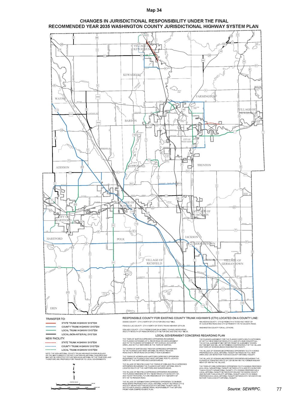
91
APPENDIX M FOR THE JEFFERSON COUNTY PORTION OF THE VISION 2050 PLAN RECOMMENDATIONS MILWAUKEE URBANIZED AREA INTRODUCTION
 INTRODUCTION Following the 2010 U.S. Census, 70 the Milwaukee urbanized area boundary extends beyond the Southeastern Wisconsin Region across the boundary line between Waukesha and Jefferson Counties,
Regional Transportation Needs Within Southeastern Wisconsin
 Regional Transportation Needs Within Southeastern Wisconsin #118274 May 24, 2006 1 Introduction The Southeastern Wisconsin Regional Planning Commission (SEWRPC) is the official areawide planning agency
PRELIMINARY DRAFT FIRST AMENDMENT TO VISION 2050: A REGIONAL LAND USE AND TRANSPORTATION PLAN FOR SOUTHEASTERN WISCONSIN
 PRELIMINARY DRAFT FIRST AMENDMENT TO VISION 2050: A REGIONAL LAND USE AND TRANSPORTATION PLAN FOR SOUTHEASTERN WISCONSIN ESTABLISHING TARGETS FOR FEDERAL PERFORMANCE MEASURES: HIGHWAY SAFETY SOUTHEASTERN
Chapter 7 TRANSPORTATION FACILITIES ELEMENT INTRODUCTION
 Chapter 7 TRANSPORTATION FACILITIES ELEMENT INTRODUCTION The transportation system of the Town of Genesee benefits all Town residents by providing for the movement of goods and people into, out of, through,
Basalt Creek Transportation Refinement Plan Recommendations
 Basalt Creek Transportation Refinement Plan Recommendations Introduction The Basalt Creek transportation planning effort analyzed future transportation conditions and evaluated alternative strategies for
City of Wayzata Comprehensive Plan 2030 Transportation Chapter: Appendix A
 A1. Functional Classification Table A-1 illustrates the Metropolitan Council s detailed criteria established for the functional classification of roadways within the Twin Cities Metropolitan Area. Table
Clackamas County Comprehensive Plan
 ROADWAYS The County s road system permits the movement of goods and people between communities and regions, using any of a variety of modes of travel. Roads provide access to virtually all property. They
# Southeastern Wisconsin Regional Freeway System Reconstruction Study and Preliminary Recommended Plan
 #70421 Southeastern Wisconsin Regional Freeway System Reconstruction Study and Preliminary Recommended Plan Public Information Meetings and Hearings May June 2002 1 Reason for Freeway System Study 270-mile
TRANSPORTATION. The intent of this chapter is to address these issues and requirements set forth by the Wisconsin Statutes.
 TRANSPORTATION Section 66.1001 (2)(c) of the Wisconsin Statutes requires the Transportation Element to provide a compilation of goals, objectives, policies, maps, and programs that guide the future development
APPROVE A RESOLUTION ADOPTING A COMPLETE STREETS POLICY
 STAFF REPORT MEETING DATE: September 13, 2016 TO: FROM: City Council Bob Brown, Community Development Director Russ Thompson, Public Works Director Patrick Filipelli, Management Analyst 922 Machin Avenue
City of Homewood Transportation Plan
 City of Homewood Transportation Plan Prepared for: City of Homewood, Alabama Prepared by: Skipper Consulting, Inc. May 2007 TABLE OF CONTENTS INTRODUCTION... 1 BACKGROUND INFORMATION... 1 EXISTING TRANSPORTATION
SEWRPC MEMORANDUM REVIEW, UPDATE, AND REAFFIRMATION OF THE YEAR 2035 REGIONAL TRANSPORTATION PLAN. Chapter 6
 PDF 151065 KRY/CTH/SD/EDL/dad/mlh/edl 4/16/10 150281 v2 Preliminary Draft (REVISED) INTRODUCTION SEWRPC MEMORANDUM REVIEW, UPDATE, AND REAFFIRMATION OF THE YEAR 2035 REGIONAL TRANSPORTATION PLAN Chapter
Policy Number: Effective: 07/11/14 Responsible Division: Planning Date: 07/11/2014 FUNCTIONAL CLASSIFICATION AMENDMENT POLICY
 Policy Number: 2014-025 Effective: 07/11/14 Responsible Division: Planning Date: 07/11/2014 FUNCTIONAL CLASSIFICATION AMENDMENT POLICY POLICY STATEMENT: The Northeast Ohio Areawide Coordinating Agency
EXECUTIVE SUMMARY OF CALEDON TRANSPORTATION NEEDS STUDY
 EXECUTIVE SUMMARY OF CALEDON TRANSPORTATION NEEDS STUDY The Caledon Transportation Needs Study has been undertaken as a joint project by the Town of Caledon and the Region of Peel to determine the existing
Exhibit 1 PLANNING COMMISSION AGENDA ITEM
 Exhibit 1 PLANNING COMMISSION AGENDA ITEM Project Name: Grand Junction Circulation Plan Grand Junction Complete Streets Policy Applicant: City of Grand Junction Representative: David Thornton Address:
INTRODUCTION THOROUGHFARE SYSTEM CLASSIFICATIONS
 INTRODUCTION The thoroughfare plan will assist public officials in the development of a specialized system for efficient and safe movement of vehicular traffic while minimizing potential conflicts with
Functional Classification of Roads and Streets
 Functional Classification of Roads and Streets J o h n E. B a e r w a ld Professor of Transportation and Traffic Engineering Director, Highway Traffic Safety Center University of Illinois, Urbana-Champaign
WHEREAS, the New Jersey Department of Transportation' s Complete Streets
 WHEREAS, the State Department of Transportation adopted a Complete Streets Policy ( Policy No. 703), effective December 3, 2009, for all projects funded through the Department' s Capital Program and strongly
FISCALLY CONSTRAINED TRANSPORTATION PLAN
 FISCALLY CONSTRAINED TRANSPORTATION PLAN 2 Credit: Hugh J. Fuller, WSP/Parsons Brinckerhoff 2.1 THE FISCALLY CONSTRAINED TRANSPORTATION PLAN Federal regulations require the Region s transportation plan
Traffic Calming Policy
 Article I. Purpose and Goal. The purpose of this policy is to establish criteria and procedures the City will use to evaluate requests for, and if appropriate, implement traffic calming measures. Neighborhood
The region is also served by Greyhound Bus Lines, Badger Coaches, Wisconsin Coach Lines, Lamers Bus Lines, and Amtrak Trains.
 TRANSPORTATION Section 66.1001 (2)(c) of the Wisconsin Statutes requires the Transportation Element to provide a compilation of goals, objectives, policies, maps, and programs that guide the future development
Transportation Policy Manual
 March 4, 2013 EXHIBIT 2 Metropolitan Transportation Planning Organization for the Gainesville Urbanized Area A Comprehensive Guide to Adopted Metropolitan Transportation Planning Organization for the
CITY OF VAUGHAN EXTRACT FROM COUNCIL MEETING MINUTES OF OCTOBER 30, 2012
 CITY OF VAUGHAN EXTRACT FROM COUNCIL MEETING MINUTES OF OCTOBER 30, 2012 Item 31, Report No. 39, of the Committee of the Whole, which was adopted without amendment by the Council of the City of Vaughan
Chapter 5 FUNCTIONAL CLASSIFICATION
 Chapter 5 FUNCTIONAL CLASSIFICATION Functional classification is a system by which streets and roadways may be distinguished by types according to their function within the entire transportation network.
METHODOLOGY. Signalized Intersection Average Control Delay (sec/veh)
") Chapter 5 Traffic Analysis 5.1 SUMMARY US /West 6 th Street assumes a unique role in the Lawrence Douglas County transportation system. This principal arterial street currently conveys commuter traffic
Chapter 5 Traffic Analysis 5.1 SUMMARY US /West 6 th Street assumes a unique role in the Lawrence Douglas County transportation system. This principal arterial street currently conveys commuter traffic
Executive Summary June 2015
 Executive Summary June 2015 Highway 112 Corridor Study Benton and Washington Counties Executive Summary June 2015 Prepared by Transportation Planning and Policy Division Arkansas State Highway and Transportation
#83875 v1 Southeastern Wisconsin Regional Freeway System Reconstruction Study and Recommended Plan. Overview and Summary June
 #83875 v1 Southeastern Wisconsin Regional Freeway System Reconstruction Study and Recommended Plan Overview and Summary June 2003 1 Reason for Freeway System Study The freeway system is nearing the end
Chapter 4 Traffic Analysis
 Chapter 4 Traffic Analysis PURPOSE The traffic analysis component of the K-68 Corridor Management Plan incorporates information on the existing transportation network, such as traffic volumes and intersection
Highway 49, Highway 351 and Highway 91 Improvements Feasibility Study Craighead County
 Highway 49, Highway 351 and Highway 91 Improvements Feasibility Study Craighead County Executive Summary March 2015 Highway 49, Highway 351 and Highway 91 Improvements Feasibility Study Craighead County
PROPOSED VISION 2050 AMENDMENT
 PROPOSED VISION 25 AMENDMENT WHAT IS VISION 25? VISION 25 is Southeastern Wisconsin s longrange land use and transportation plan. It makes recommendations to local and State government to shape and guide
Corporate. Report COUNCIL DATE: June 26, 2006 NO: C012 COUNCIL-IN-COMMITTEE. TO: Mayor & Council DATE: June 22, 2006
 Corporate NO: C012 Report COUNCIL DATE: June 26, 2006 COUNCIL-IN-COMMITTEE TO: Mayor & Council DATE: June 22, 2006 FROM: General Manager, Engineering FILE: 0410-20(MoT/Gate) SUBJECT: Surrey Response on
VDOT BICYCLE & PEDESTRIAN IMPLEMENTATION GUIDE FOR LOCALITY INVOLVEMENT April 2017
 VDOT BICYCLE & PEDESTRIAN IMPLEMENTATION GUIDE FOR LOCALITY INVOLVEMENT April 2017 1 TABLE OF CONTENTS Topic Page(s) About this Guide 3 Encouraging development of bicycle and pedestrian plans by localities
VISION. Introduction WHAT S INSIDE. One Region, Focusing on Our Future
 VISION 2050 One Region, Focusing on Our Future A publication of the Southeastern Wisconsin Regional Planning Commission Fall 2015 THE ALTERNATIVES THE EVALUATION WHAT S INSIDE Land Use pgs. 2-3 Public
Goodlettsville Bicycle and Pedestrian Plan Executive Summary
 Goodlettsville Bicycle and Pedestrian Plan July 2010 In Cooperation with the Nashville Area Metropolitan Planning Executive Organization Summary Introduction Progressive and forward thinking communities
Chapter 6: Transportation
 Chapter 6: Transportation I. INTRODUCTION The purpose of the Transportation Plan element of the Comprehensive Plan is to provide guidance to the City of North Mankato, as well as existing and future landowners
TRAFFIC STUDY GUIDELINES Clarksville Street Department
 TRAFFIC STUDY GUIDELINES Clarksville Street Department 9/1/2009 Introduction Traffic studies are used to help the city determine potential impacts to the operation of the surrounding roadway network. Two
o n - m o t o r i z e d transportation is an overlooked element that can greatly enhance the overall quality of life for the community s residents.
 N o n - m o t o r i z e d transportation is an overlooked element that can greatly enhance the overall quality of life for the community s residents. 84 Transportation CHAPTER 11 INTRODUCTION Transportation
3.0 Future Conditions
 3.0 Future Conditions In order to be able to recommend appropriate improvements to the transportation system of the Town, it is important to first understand the nature and volume of traffic that is expected
Tulsa Metropolitan Area LONG RANGE TRANSPORTATION PLAN
 Tulsa Metropolitan Area LONG RANGE TRANSPORTATION PLAN Indian Nations Council of Governments August 2005 CONTACTING INCOG In developing the Destination 2030 Long Range Transportation Plan, INCOG s Transportation
Circulation in Elk Grove includes: Motor vehicles, including cars and trucks
 Circulation, as it is used in this General Plan, refers to the many ways people and goods move from place to place in Elk Grove and the region. Circulation in Elk Grove includes: Motor vehicles, including
CHAPTER 7 CIRCULATION
 CHAPTER 7 CIRCULATION A township s transportation network links its population with the surrounding communities. Transportation networks, including public and private, provide the means by which township
Chapter 7. Transportation. Transportation Road Network Plan Transit Cyclists Pedestrians Multi-Use and Equestrian Trails
 Chapter 7 Transportation Transportation Road Network Plan Transit Cyclists Pedestrians Multi-Use and Equestrian Trails 7.1 TRANSPORTATION BACKGROUND The District of Maple Ridge faces a number of unique
Gordon Proctor Director Policy on Accommodating Bicycle and Pedestrian Travel on ODOT Owned or Maintained Facilities
 Approved: Policy: 20-004(P) Responsible Office: Planning Gordon Proctor Director Policy on Accommodating Bicycle and Pedestrian Travel on ODOT Owned or Maintained Facilities I. POLICY STATEMENT: This policy
DESIGN MEMORANDUM WITH DESIGN EXCEPTIONS SP SP
 DRAFT NOT FINAL (Note: document was not finalized due to an eastbound stopping site distance design issue that requires more detailed bridge and roadway design considerations. This discussion starts on
RESOLUTION NO A RESOLUTION OF THE CITY COUNCIL OF THE CITY OF MENLO PARK ADOPTING A COMPLETE STREETS POLICY
 RESOLUTION NO. 6123 A RESOLUTION OF THE CITY COUNCIL OF THE CITY OF MENLO PARK ADOPTING A COMPLETE STREETS POLICY WHEREAS, the term Complete Streets describes a comprehensive, integrated transportation
MASTER THOROUGHFARE PLAN
 MASTER THOROUGHFARE PLAN Master Thoroughfare Plan Update November 2015 Prepared for Town of Northlake AVO 30659 11/11/2015 1201 North Bowser Road Richardson, Texas 75081 Firm Registration No. 312 MASTER
Third Street Bridge & Corridor Project
 Third Street Bridge & Corridor Project Preparation for the FY2018 budget to commence October 1, 2017, includes funding to address a project that has been considered since 1994. The Third Street bridge
BIKE & PEDESTRIAN IMPLEMENTATION GUIDE FOR LOCALITY INVOLVEMENT. November 2006
 BIKE & PEDESTRIAN IMPLEMENTATION GUIDE FOR LOCALITY INVOLVEMENT November 2006 1 of 9 TABLE OF CONTENTS Topic Page(s) Encouraging development of Bike and pedestrian plans by localities 3 5 Involving localities
West Dimond Blvd Upgrade Jodhpur Street to Sand Lake Road
 West Dimond Blvd Jodhpur St to Sand Lake CSS Transportation Project Summary Municipality of Anchorage Project # 05 005 Project Manager: John Smith, P.E. (MOA PM&E) Project Administrator: Julie Makela,
RESOLUTION NO ?? A RESOLUTION OF THE CITY OF NEPTUNE BEACH ADOPTING A COMPLETE STREETS POLICY
 RESOLUTION NO. 2018-?? A RESOLUTION OF THE CITY OF NEPTUNE BEACH ADOPTING A COMPLETE STREETS POLICY WHEREAS, safe, convenient, and accessible transportation for all users is a priority of the City of Neptune
Highway 111 Corridor Study
 Highway 111 Corridor Study June, 2009 LINCOLN CO. HWY 111 CORRIDOR STUDY Draft Study Tea, South Dakota Prepared for City of Tea Sioux Falls Metropolitan Planning Organization Prepared by HDR Engineering,
ACTION FORM BRYAN CITY COUNCIL
 ACTION FORM BRYAN CITY COUNCIL DATE OF COUNCIL MEETING: February 25, 2014 DATE SUBMITTED: February 6, 2014 DEPARTMENT OF ORIGIN: Development Services SUBMITTED BY: Martin Zimmerman MEETING TYPE: CLASSIFICATION:
SANTA CLARA COUNTYWIDE BICYCLE PLAN August 2008
 SANTA CLARA COUNTYWIDE BICYCLE PLAN August 2008 To assist VTA and Member Agencies in the planning, development and programming of bicycle improvements in Santa Clara County. Vision Statement To establish,
TRAFFIC IMPACT STUDY CRITERIA
 Chapter 6 - TRAFFIC IMPACT STUDY CRITERIA 6.1 GENERAL PROVISIONS 6.1.1. Purpose: The purpose of this document is to outline a standard format for preparing a traffic impact study in the City of Steamboat
APPENDIX 2 LAKESHORE ROAD TRANSPORTATION REVIEW STUDY EXECUTIVE SUMMARY
 APPENDIX 2 LAKESHORE ROAD TRANSPORTATION REVIEW STUDY EXECUTIVE SUMMARY Appendix 2 City of Mississauga Lakeshore Road FINAL REPORT Transportation Review Study December 2010 EXECUTIVE SUMMARY Study Purpose
Town of Clarkstown Traffic Calming Program. Table of Contents
 Town of Clarkstown Traffic Calming Program Table of Contents I. INTRODUCTION a. Purpose & Intent b. Key to Successful Projects c. What is Traffic Calming? II. Definitions III. Street Classification IV.
Street Paving and Sidewalk Policy
 City Commission Policy 600 Street Paving and Sidewalk Policy DEPARTMENT: Public Works DATE ADOPTED: June 7, 1995 DATE OF LAST REVISION: December 10, 2014 Policy No. 600.01 AUTHORITY: PASS City of Tallahassee-Leon
SCHOOL CROSSING PROTECTION CRITERIA
 CITY OF MADISON TRAFFIC ENGINEERING SCHOOL CROSSING PROTECTION CRITERIA January 2016 Adopted as Policy on August 31, 1976, by Common Council by Amended Resolution #29,540 Amended on September 14, 1976,
Transportation Development Act Grant Radar Check Speed Signs
 City Council Agenda January 18, 2017 To: From: Subject: Mayor and City Council Tim Tucker, City Engineer Transportation Development Act Grant Radar Check Speed Signs Date: January 10, 2017 Recommendation
City of Elizabeth City Neighborhood Traffic Calming Policy and Guidelines
 City of Elizabeth City Neighborhood Traffic Calming Policy and Guidelines I. Purpose: The City of Elizabeth City is committed to ensure the overall safety and livability of residential neighborhoods. One
CIRCULATION ELEMENT ADOPTED 1980 REPUBLISHED APRIL 2014 County of Santa Barbara Planning and Development 123 E. Anapamu Street Santa Barbara, CA 93101
 CIRCULATION ELEMENT ADOPTED 1980 REPUBLISHED APRIL 2014 County of Santa Barbara Planning and Development 123 E. Anapamu Street Santa Barbara, CA 93101 The electronic version of the Santa Barbara County
Roadway Classification Design Standards and Policies. Pueblo, Colorado November, 2004
 Roadway Classification Design Standards and Policies Pueblo, Colorado November, 2004 Table of Contents Page Chapter 1. General Provisions 1.1 Jurisdiction 3 1.2 Purpose and Intent 3 1.3 Modification 3
This page intentionally left blank.
 This page intentionally left blank. COMMUNITY Coweta Community Overview Coweta Coweta, a residential community located in Wagoner County, is a suburb of Tulsa situated southeast of the metropolitan area
Michael Parmer, Management Aide, City Manager's Office
 P139 STAFF REPORT f CITY NL- NAGER' S OFFICE RANCHO Date: C;UCAMONGA To: From: Subject: Mayor and Members of the City Council John R. Gillison, City Manager Michael Parmer, Management Aide, City Manager's
SAN FRANCISCO MUNICIPAL TRANSPORTATION AGENCY BOARD OF DIRECTORS. RESOLUTION No
 SAN FRANCISCO MUNICIPAL TRANSPORTATION AGENCY BOARD OF DIRECTORS RESOLUTION No. 15-031 WHEREAS, Transportation Code Division II, Section 909 authorizes the Director of Transportation to install and permit
TRANSPORTATION & MOBILITY
 TRANSPORTATION & MOBILITY ROADWAY SYSTEM There are approximately 40 miles of roadways in Manitou Springs. For planning purposes, roadways are typically assigned a functional classification which defines
City of Tamarac, Florida Traffic Calming Policy
 City of Tamarac, Florida Traffic Calming Policy Temp. Reso. 12614 Exhibit 1 I. Introduction: The City of Tamarac recognizes that the conditions of residential streets can greatly affect neighborhood livability
SECTION 1 - TRAFFIC PLANNING
 SECTION 1 - TRAFFIC PLANNING 1.1 TRAFFIC OPERATIONS 1.1.1 Roadway Functional Classification The Multnomah County Comprehensive Framework Plan s Policy 34: Trafficways and the Functional Classification
3 ROADWAYS 3.1 CMS ROADWAY NETWORK 3.2 TRAVEL-TIME-BASED PERFORMANCE MEASURES Roadway Travel Time Measures
 ROADWAYS Approximately 6 million trips are made in the Boston metropolitan region every day. The vast majority of these trips (80 to percent, depending on trip type) involve the use of the roadway network
FMATS Transportation Improvement Program Project Nomination Form
 FMATS 2015 2018 Transportation Improvement Program Project Nomination Form Project nominations are accepted from the public and are scored based on the adopted Project Scoring Criteria. These criteria
TRASBURG RANSPORTATION
 TRASBURG RANSPORTATION LAN DEVELOPED BY THE TRANSPORTATION PLANNING DIVISION OF THE VIRGINIA DEPARTMENT OF TRANSPORTATION IN COOPERATION WITH THE U.S. DEPARTMENT OF TRANSPORTATION, FEDERAL HIGHWAY ADMINISTRATION
Roadway Classification Review
 District of North Vancouver 355 West Queens Road North Vancouver British Columbia V7N 4N5 Roadway Classification Review District of North Vancouver January 2013 District of North Vancouver Roadway Classification
Mobility and Congestion
 Technical Memorandum Mobility and Congestion Prepared for: Prepared by: September 25, 2013 1 Table of Contents 1. Introduction... 1 2. Congestion Forecasting Process... 1 2.1 Mobility and Congestion Terms...
Traffic Impact Study. Westlake Elementary School Westlake, Ohio. TMS Engineers, Inc. June 5, 2017
 TMS Engineers, Inc. Traffic Impact Study Westlake Elementary School Westlake, Ohio June 5, 2017 Prepared for: Westlake City Schools - Board of Education 27200 Hilliard Boulevard Westlake, OH 44145 TRAFFIC
5.0 Roadway System Plan
 Southwest Boise Transportation Study Page 16 5.0 Roadway System Plan The Roadway System Plan outlines roadway improvements in the Initial Study Area. It forecasts future deficiencies on the arterial system,
City of Gainesville Transportation/Roadway Needs PROJECT SUMMARY
 A1 Roadway Resurfacing $23,846,000 TYPE: Preservation of existing system Roadway resurfacing A2 Signal Replacement $6,000,000 TYPE: Preservation of existing system Replace traffic signals. B1 W 6th St
Develop a Multi-Modal Transportation Strategy (Theme 6)
") DEVELOP A MULTI-MODAL TRANSPORTATION STRATEGY (THEME 6) WHY IS THIS THEME ADDRESSED? Develop a Multi-Modal Transportation Strategy (Theme 6) Statement of Ideal Reduce resident and visitor reliance on single
DEVELOP A MULTI-MODAL TRANSPORTATION STRATEGY (THEME 6) WHY IS THIS THEME ADDRESSED? Develop a Multi-Modal Transportation Strategy (Theme 6) Statement of Ideal Reduce resident and visitor reliance on single
MUTCD Part 6G: Type of Temporary Traffic Control Zone Activities
 MUTCD Part 6G: Type of Temporary Traffic Control Zone Activities 6G.01 Typical Applications Each temporary traffic control (TTC) zone is different. Many variables, such as location of work, highway type,
BEFORE THE BOARD OF COMMISSIONERS OF LANE COUNTY, OREGON
 BEFORE THE BOARD OF COMMISSIONERS OF LANE COUNTY, OREGON ORDINANCE NO. PA 1314 IN THE MATTER OF CO-ADOPTING THE COBURG TRANSPORTATION SYSTEM PLAN FOR APPLICATION WITHIN THE URBANIZABLE AREA OUTSIDE THE
Secondary Road Program
 Secondary Road Program Joint Legislative Transportation Oversight Committee October 5, 2012 1 Secondary Roads Program The Big Picture The Secondary Road System Needs and Project Types Paved and Unpaved
Recommended Roadway Plan Section 2 - Land Development and Roadway Access
 Recommended Roadway Plan Section 2 - Land Development and Roadway Access SECTION 2 Land Development and Roadway Access 2.1 Land Use and Access Management The Federal Highway Administration (FHWA) defines
CITY OF LUCAS 2014 MASTER THOROUGHFARE PLAN
 INTRODUCTION CITY OF LUCAS 2014 MASTER THOROUGHFARE PLAN A thoroughfare system is intended to provide an effective means of moving vehicles within and through a city. The thoroughfare plan will assist
Non-Motorized Transportation 7-1
 Non-Motorized Transportation 7-1 Transportation facilities no longer mean just accommodating a vehicle powered by a combustion engine. Pedestrian and non-motorized facilities are important modes of travel
ITEM 3 ATTACHMENT A RESOLUTION NO
 ITEM 3 ATTACHMENT A RESOLUTION NO. 2018-1575 A RESOLUTION OF THE CITY COUNCIL OF THE CITY OF CALABASAS, CALIFORNIA, ADOPTING THE FISCAL YEAR 2017-18 LIST OF PROJECTS FUNDED BY SB 1: THE ROAD REPAIR AND
Southeastern Wisconsin Regional Planning Commission SUMMARY
 Southeastern Wisconsin Regional Planning Commission REGIONAL BICYCLE AND PEDESTRIAN SYSTEM PLAN SUMMARY A bicycle and pedestrian facilities system plan for Southeastern Wisconsin was adopted by the Southeastern
City of Bartow Comprehensive Plan. Transportation Element
 City of Bartow 2030 Comprehensive Plan Amended through January 7, 2013 TRANSPORTATION ELEMENT GOAL: IT SHALL BE A GOAL OF THE CITY OF BARTOW TO PROVIDE A SAFE AND EFFICIENT MULTI-MODAL TRANSPORTATION SYSTEM
TRAFFIC CALMING POLICY & PROCEDURES
 TRAFFIC CALMING POLICY & PROCEDURES AS ADOPTED BY MONTCLAIR TOWNSHIP COUNCIL AUGUST 4, 2009 TABLE OF CONTENTS 1. INTRODUCTION... 2 Purpose... 2 Traffic Calming Definition... 2 Statement Of Township Council
APPENDIX G: INTERSECTION NEEDS AT OKEECHOBEE BOULEVARD
 APPENDIX G: INTERSECTION NEEDS AT OKEECHOBEE BOULEVARD INTERSECTION NEEDS AT SR 7 and OKEECHOBEE BOULEVARD SR 7 Extension Project Development and Environment (PD&E) Study From Okeechobee Boulevard (SR
4APNOIPF Vh, YII PTC CITY COUNCIL AGENDA REPORT. Honorable Mayor and City Council Members. 8K TH 63 River Crossing Bridge Replacement Project
 City of RE 4APNOIPF Vh, X` W\ YII PTC ING, CITY COUNCIL AGENDA REPORT Council Meeting Date: September 26, 2016 To: From: Agenda Item: Honorable Mayor and City Council Members Ron Rosenthal, Engineering
ADOT Statewide Bicycle and Pedestrian Program Summary of Phase IV Activities APPENDIX B PEDESTRIAN DEMAND INDEX
 ADOT Statewide Bicycle and Pedestrian Program Summary of Activities APPENDIX B PEDESTRIAN DEMAND INDEX May 24, 2009 Pedestrian Demand Index for State Highway Facilities Revised: May 29, 2007 Introduction
MONTGOMERY COUNTY PLANNING DEPARTMENT THE MARYLAND-NATIONAL CAPITAL PARK AND PLANNING COMMISSION
 MONTGOMERY COUNTY PLANNING DEPARTMENT THE MARYLAND-NATIONAL CAPITAL PARK AND PLANNING COMMISSION MCPB Item No. 3 Date: 01-19-12 Worksession: Countywide Transit Corridors Functional Master Plan Larry Cole,
Sixth Line Development - Transit Facilities Plan
 Memorandum Date: November 13, 2012 To: From: c.c. Subject: Rob Freeman (Freeman Planning) Kevin Phillips Sixth Line Development - Transit Facilities Plan 33016631 This memo was prepared to review the transit
CHAPTER 7 ACCESS MANAGEMENT. Background. Principles of Access Management. Hennepin County Transportation Systems Plan (HC-TSP)
") CHAPTER 7 ACCESS MANAGEMENT Background Principles of Access Management Hennepin County Transportation Systems Plan (HC-TSP) Chapter 7 Access Management 7.1 Background Access management has become an important
CHAPTER 7 ACCESS MANAGEMENT Background Principles of Access Management Hennepin County Transportation Systems Plan (HC-TSP) Chapter 7 Access Management 7.1 Background Access management has become an important
#82820 v1 Southeastern Wisconsin Regional Freeway System Reconstruction Study and Recommended Plan. Myths and Facts. May Myths to be Addressed
 #82820 v1 Southeastern Wisconsin Regional Freeway System Reconstruction Study and Recommended Plan Myths and Facts May 2003 Myths to be Addressed The Regional Planning Commission is only concerned with
Phone: Fax: Project Reference No. (to be filled out by MassHighway):
:") Massachusetts Highway Department District 3 Project Need Form (PNF) This form is intended to provide preliminary information about the proposed project. It is not expected that all information that is
Massachusetts Highway Department District 3 Project Need Form (PNF) This form is intended to provide preliminary information about the proposed project. It is not expected that all information that is
Madison Urban Area and Dane County. Bicycle Transportation Plan Summary. September Introduction. Bicycle Plan Scope and Planning Process
 Bicycle Transportation Plan Summary Madison Urban Area and Dane County Introduction September 2000 Bicycling is an important mode of transportation in the Madison urban area and countywide that is available
South King County High-Capacity Transit Corridor Study
 HIGH-CAPACITY TRANSIT CORRIDOR STUDY South King County Corridor South King County High-Capacity Transit Corridor Study Corridor Report August 2014 South King County High Capacity Transit Corridor Report
Transportation. Introduction
 Transportation 6 Introduction As the City of Johnston continues to grow the demand placed on the transportation network will increase as well. The ability of the network to handle this increased demand
Pedestrian Crosswalk Audit
 1200, Scotia Place, Tower 1 10060 Jasper Avenue Edmonton, Alberta T5J 3R8 edmonton.ca/auditor Pedestrian Crosswalk Audit June 19, 2017 The conducted this project in accordance with the International Standards
CONNECTING PEOPLE TO PLACES
 CONNECTING PEOPLE TO PLACES 82 EAST BENCH MASTER PLAN 07 Introduction The East Bench transportation system is a collection of slow moving, treelined residential streets and major arteries that are the