Carmel, Indiana Illinois Street and 126th Street Westfield Boulevard and 96th Street Arts and Design District RAB
|
|
|
- Helen Preston
- 5 years ago
- Views:
Transcription


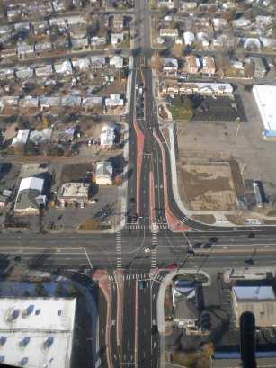
1 Sustainability Benefits Of Network Wide Roundabout Use Case Study of Carmel, Indiana Presented By: Michael McBride PE Carmel City Engineer Carmel, Indiana Carmel, Indiana 1996 Carmel, Indiana Population 38,000 up from 25,000 in 1990 Jurisdictional Area of 13 Square Miles Rapid Population Growth was Expected to Continue Population Growth Means Growth in Traffic An Abundance of 4-Way Stop Controlled Intersections and some Signalized Intersections were Contributing to Congestion in Peak Hours. Mayor Jim Brainard Takes Office Of Mayor Illinois Street and 126 th Street Westfield Boulevard and 96 th Street Carmel Introduces Roundabouts 1997 Mayor Jim Brainard Proved Quickly to be a Driven Leader With Exceptional Vision Clear Understanding That Safe, Efficient Transportation Infrastructure Promotes Quality of Life & Successful Economic Development Awareness of Roundabout Success in Other Areas (England and Vail, CO) Insisted on Inclusion of Roundabouts In Hazel Dell Project In Spite of Opposition from Outspoken Minority Carmel s First Roundabouts Hazel Dell Parkway Corridor Constructed in 1998 Two Intersections Along This 5-Mile, Four-Lane Boulevard Were Chosen to be Controlled by Multi- Lane Roundabouts Limited Roundabout Design Guidance Available Designers Referenced British and Australian Standards Designs Were Reviewed by Vail Roundabout Designers as well as British Designers Hazel Dell Pkwy Video Clip 1


2 Roundabout Benefits Recognized Safety! Safety! Safety! Less Severe Crashes Means Lower Cost Crashes Construction and Operation Cost Savings Efficiency Benefits of Roundabouts Environmental Benefits Aesthetic & Quality of Life Benefits Roadway Improvements Present Opportunity To Enhance Property Value & Encourage Private Investment First Roundabouts A Success Hazel Dell Roundabout Considered a Great Success Roundabouts Gain Public Acceptance In Carmel Four Roundabouts Constructed in Brainard s First Term ( 96-99) Success Of Early Roundabouts Prompt City Officials to Rethink Use of Roundabouts in Comprehensive Plan Planning Incorporates Roundabouts One Mile Grid Public Land Survey Road System Blank Slate for Development Planning Incorporates Roundabouts Subdivision Infill With Internal Street Connectivity Despite Connectivity Traffic Grows on Primary Road Grid Planning Incorporates Roundabouts Greater Capacity Needed on Primary Grid Streets But No One Wants to Live Next to a Highway Roundabouts The Obvious Choice Desire to FULLY and Safely Utilize the City s Existing Grid System of Streets City Land Use Plans Encouraged Traditional Neighborhood Development, Wide Nodes, Narrow Roads Concept Equally Functional System of Parallel Roads That Maximizes Single Lane Capacity. Pedestrian and Bicycle Friendly Transportation Corridors Maintain Residential Roadway Experience When Possible 2


3 Roundabout Implementation Plan Carmel Roundabout Locations Access Management Preservation of Residential Roadway Feel Requires Strict Access Management Policy in Conjunction with Roundabouts Access Management Roundabouts at Blvd. Street Junctions Provide Safe U-Turn Opportunity Access Management Quality of Life Benefits 3


 Carmel, Indiana Carmel s Population Grew from 38,000 in 1996 to 80,000 in 2010 Over")

 Illinois Street and 126 th Street Westfield Boulevard and 96 th Street City Wide")

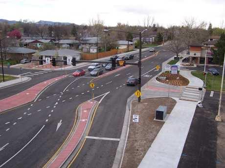
4 Quality of Life Benefits Westfield Blvd. & 96 th St. Signal Conversion Video Comparison Before & After Carmel Experiences Safety Benefits City Wide Crash Data Accident Damage Cost Savings Average Cost of Accident Signal $10,500 % Accidents With Injury at All Intersections 29% % Accidents % Accidents With Injury at With Injury at Single Lane Roundabouts Dual Lane Roundabouts 4% 7% vs. Roundabout $2,500 Average Cost of Accident has been Reduced by $3,000 (Statistics from Carmel Police Dept. 2007) Carmel, Indiana Carmel s Population Grew from 38,000 in 1996 to 80,000 in 2010 Over the past 8 years, Carmel has invested over $500 Million in transportation infrastructure Carmel currently has 67 roundabouts in place, and another 16 that are currently in design. City named one of best places to live in America (Money Magazine Dec. 2003) Illinois Street and 126 th Street Westfield Boulevard and 96 th Street City Wide Accident Reduction Carmel roundabout now number 63 and signalized intersections have been decreased to only 39. What has been the impact on the safety of Carmel s roadway network as a whole Data Carmel Road Miles = 220 Total Injury Accidents = Data Carmel Road Miles = 395 Total Injury Accidents = % Decrease in Injury Accidents/Road Mile 4


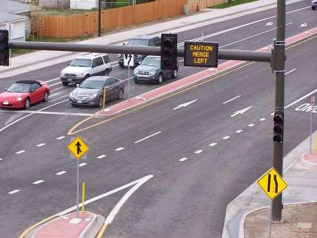
5 Roundabout WILL Be Option #1 Lessons Learned Hazel Dell Parkway Geometric Adjustments 2020 design AADT s were projected to be 12,840 Hazel Dell currently carries more than 25,000 VPD Flat entry paths allowed for higher entry speeds Entry path overlap also observed as an issue Frequency of minor accidents higher than desired Injury accidents still consistent with other roundabouts Hazel Dell & 126 th St. Roundabout Current Configuration Hazel Dell & 126 th St. Roundabout Hazel Dell & 131 st St. Roundabout Proposed Configuration Completed


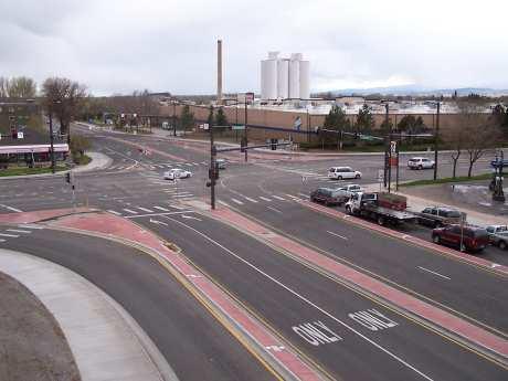
6 Hazel Dell & Cherry Creek Blvd. Roundabout Carmel s First Roundabout Interchanges 2010 Construction Existing Keystone Avenue Looking South at Carmel Drive and 116 th Street Intersections Keystone Parkway (Formerly SR 431) US 31 Existing Corridor Keystone Avenue Existing Traffic Conditions Corridor Formed a Significant Barrier Dividing the Community Safety and Quality of Life Concerns All intersections operating at a LOS D or worse State s Plan Was to Add Travel Lanes Adding travel lanes would only improve corridor to LOS D Grade separations warranted, but funding focused on Parallel US 31 Corridor Improvements Keystone Avenue and 96 th Street Keystone Avenue and 126 th Street 106 th St. & Keystone Pkwy 106 th St. & Keystone Pkwy Before After 6


7 126 th St. & Keystone Pkwy 126th St. & Keystone Pkwy Before After Integration of VISSIM with 3D Modeling Fifty Mile Radius and Beyond 99 Roundabouts By 2011 Questions? Mike McBride, PE One Civic Square Carmel, IN (317)


8 Loveland, Colorado Sweet Heart City Roundabout-Sustainability Solving Access Needs The 2010 Experience - 2 Interchanges/ 1 Intersection High Growth Burst - Long term savings along the Gateway to the Rockies 1


 4400 5300 FOXTRAIL DR N 2300 6300 Intersection Differences for Sustainability I-25/Crossroads 0 signals I-25/US")
9 ROCKY MOUNTAIN AVE Loveland Intersections Modern Roundabouts 20/2011 up from 6 in 2005 and 0 in 997 Traffic Signals: 49 in1995 now 93 70,000 People up from 50,000 in 2000 High Growth >>> Lifestyles Mall + Regional Hospital + Motorplex + Events Ctr.+ Budweiser Events Ctr.+++ Roundabout #1 Designed and Constructed 1998 Problem solved Spacing/Stacking Ourston and Doctors Design 5 accidents 1 injury crash reported by 2005 Saved 65 w/9 injury crashes (est.) FOXTRAIL DR N Intersection Differences for Sustainability I-25/Crossroads 0 signals I-25/US 34 2 Signals Madison/US 34 CFI 3 Signals Support Systems for Signals Operations Maintenance Computers/Communications/IT 2


10 Wide Roads, Narrow Nodes? New Interchange Roundabouts Right Thru Left 0 min min min min Total Modified + 2 Signals Total min. min. min. min. 0 min. 15 min min. min. Total Left Right Thru Thru Right Left Left Thru Right Total 0 min min min min Total Total Entering Roundabout 0 min min min min. 411 Total

11 Madison Ave./ US 34 CFI 4


12 Traffic Operations Center Contact Information Bill Hange, PE, PTOE City of Loveland City Traffic Engineer Office Phone #
Road Diets FDOT Process
 Florida Department of TRANSPORTATION Road Diets FDOT Process Humberto Castillero, PE, PTOE Roadway Design Office Purpose of Guide Develop a statewide lane elimination review process Balance state & local
Development Opportunities Golden, Colorado Case Study
 Development Opportunities Golden, Colorado Case Study Minnesota Roundabout Conference April 5-6, 5 2006 Alex J. Ariniello, P.E., P.T.O.E. Overview Golden Roundabouts Other roundabout applications Retail/business
Route 7 Corridor Study
 Route 7 Corridor Study Executive Summary Study Area The following report analyzes a segment of the Virginia State Route 7 corridor. The corridor study area, spanning over 5 miles in length, is a multi
Modern Roundabouts. BY : Mark T. Johnson, P.E. An Informational Presentation Prepared For:
 Modern Roundabouts An Informational Presentation Prepared For: Transportation Research Board Roundabout Conference Vail, CO May 2005 Roundabout implementation in constrained urban environment - achieving
INNOVATIVE INTERSECTION SOLUTIONS. Jay Bockisch, PE, PTOE Senior Associate
 INNOVATIVE INTERSECTION SOLUTIONS Jay Bockisch, PE, PTOE Senior Associate INNOVATIVE INTERSECTION SOLUTIONS Innovative intersection overview Case studies Continuous flow intersection Modern roundabouts
Access Management Regulations and Standards
 Access Management Regulations and Standards January 2014 Efficient highway operation Reasonable property access Concept of Access Management The way to manage access to land development while preserving
4. ENVIRONMENTAL IMPACT ANALYSIS 9. TRANSPORTATION AND TRAFFIC
 4. ENVIRONMENTAL IMPACT ANALYSIS 9. TRANSPORTATION AND TRAFFIC 4.9.1 INTRODUCTION The following section addresses the Proposed Project s impact on transportation and traffic based on the Traffic Study
3.0 Future Conditions
 3.0 Future Conditions In order to be able to recommend appropriate improvements to the transportation system of the Town, it is important to first understand the nature and volume of traffic that is expected
Highway 49, Highway 351 and Highway 91 Improvements Feasibility Study Craighead County
 Highway 49, Highway 351 and Highway 91 Improvements Feasibility Study Craighead County Executive Summary March 2015 Highway 49, Highway 351 and Highway 91 Improvements Feasibility Study Craighead County
INNOVATIVE INTERSECTION DESIGN
 INNOVATIVE INTERSECTION DESIGN J. Eddie Valtier, P.E. ELP TP&D Director Introduction Why Do We Need To Start Looking For Innovative Intersection Designs? Congestion is worsening and traffic volumes and
City of Gainesville Transportation/Roadway Needs PROJECT SUMMARY
 A1 Roadway Resurfacing $23,846,000 TYPE: Preservation of existing system Roadway resurfacing A2 Signal Replacement $6,000,000 TYPE: Preservation of existing system Replace traffic signals. B1 W 6th St
RM 620 FEASIBILITY STUDY
 RM 620 FEASIBILITY STUDY Sections 5 & 6 December 7, 2015 STUDY PROCESS Study Purpose and Goals The RM 620 Feasibility Study was launched by the Texas Department of Transportation (TxDOT) to analyze transportation
INNER LOOP EAST. AIA Rochester Annual Meeting November 13, 2013 TRANSFORMATION PROJECT. Bret Garwood, NBD Erik Frisch, DES
 INNER LOOP EAST TRANSFORMATION PROJECT AIA Rochester Annual Meeting November 13, 2013 Bret Garwood, NBD Erik Frisch, DES Why? We are building a city that encourages walking, biking and enjoying the outdoor
Bike Routes Assessment: 95 Ave, 106 St & 40 Ave. Replace with appropriate image in View > Master.
 Bike Routes Assessment: 95 Ave, 106 St & 40 Ave Replace with appropriate image in View > Master. Transportation Committee October 15, 2014 City Council Direction What we are trying to achieve The Way Ahead:
Access Management Regulations and Standards
 Access Management Regulations and Standards Efficient highway operation Reasonable property access Concept of Access Management The way to manage access to land development while simultaneously preserving
CITY OF COCOA BEACH 2025 COMPREHENSIVE PLAN. Section VIII Mobility Element Goals, Objectives, and Policies
 CITY OF COCOA BEACH 2025 COMPREHENSIVE PLAN Section VIII Mobility Element Goals, Objectives, and Policies Adopted August 6, 2015 by Ordinance No. 1591 VIII MOBILITY ELEMENT Table of Contents Page Number
Roundabouts are good for business
 Roundabouts are good for business What is a roundabout Rules 0f Roundabouts 1. Slow down when approaching a roundabout 2. Yield to vehicles in the roundabout 3. When clear, proceed right into the roundabout
Linking Transportation and Health in Nashville & Middle Tennessee
 Linking Transportation and Health in Nashville & Middle Tennessee Fit Nation New Orleans CPPW Mentoring Grant Built Environment Program May 14, 2011 Local Transportation Planning Framework Federal U.S.
JCE 4600 Transportation Engineering. Traffic Control
 JCE 4600 Transportation Engineering Traffic Control Human Factors Primary Driving Tasks NAVIGATION GUIDANCE CONTROL What makes a Traffic Control Device Effective? Fulfill a need Command Attention Convey
Session 76 Pedestrians and Intersections
 Session 76 Pedestrians and Intersections Moderator: Meg Storrow, RLA Storrow Kinsella Associates Andrew Gast-Bray, PhD, AICP Storrow Kinsella Associates (former) Michael Koslow, PE Storrow Kinsella Associates
Proposed. City of Grand Junction Complete Streets Policy. Exhibit 10
 Proposed City of Grand Junction Complete Streets Policy Exhibit 10 1 City of Grand Junction Complete Streets Policy Vision: The Complete Streets Vision is to develop a safe, efficient, and reliable travel
Feasibility Study of Pedestrian Crossings Along Route 7, East of Cascades Parkway and West of Dranesville Road. October 3, 2017
 Feasibility Study of Pedestrian Crossings Along Route 7, East of Cascades Parkway and West of Dranesville Road October 3, 2017 Study Area (area within a ¼-mile radius of the study intersections) Route
County Board Workshop
 CH 21 Downtown Reconstruction Project County Board Workshop Tuesday, October 24, 2017 CH 21 Downtown Prior Lake Reconstruction Agenda 1) Review remaining Project Alternatives 2) Public Engagement Summary
Roundabouts in Edmonton - A Comparison to the State-of-the-Art
 Roundabouts in Edmonton - A Comparison to the State-of-the-Art Authors: Carl Clayton, P.Eng. P.E. PTOE Stantec Consulting Ltd. Chuan Kua, P.Eng. City of Edmonton, Transportation and Streets Brice Stephenson,
133 rd Street and 132 nd /Hemlock Street 132 nd Street and Foster Street MINI ROUNDABOUTS. Overland Park, Kansas
 133 rd Street and 132 nd /Hemlock Street 132 nd Street and Foster Street MINI ROUNDABOUTS Overland Park, Kansas September 1, 2017 TABLE OF CONTENTS 1. INTRODUCTION... 1 2. LITERATURE REVIEW... 1 3. CONCEPT
Roundabouts In Colorado
 Roundabouts In Colorado ABSTRACT The first modern roundabout in Colorado was built in Colorado Springs in 1983. The construction of roundabouts in Vail and Avon, Colorado in the mid 1990 s aroused the
Balancing Operation & Safety for Motorized and Non-Motorized Traffic
 Balancing Operation & Safety for Motorized and Non-Motorized Traffic Brian Willham, PE, PTOE Iowa Director - MOVITE June 30, 2014 Learning Objectives: When & Why should we measure the performance of complete
Vision: Traditional hamlet with an attractive business/pedestrian friendly main street connected to adjacent walkable neighborhoods
 N D. Focus Area II Vision: Traditional hamlet with an attractive business/pedestrian friendly main street connected to adjacent walkable neighborhoods Transit Road Focus Area II is located in the Hamlet
PEDESTRIAN ACCOMMODATIONS DPS 201 AT INTERCHANGES
 PEDESTRIAN ACCOMMODATIONS DPS 201 AT INTERCHANGES UNDERSTANDING THE ISSUES Intersections of freeway ramp terminals at crossroads are the most critical components of an interchange Challenge: balance mobility
Building Great Neighbourhoods BELLEVUE AND VIRGINIA PARK
 Building Great Neighbourhoods BELLEVUE AND VIRGINIA PARK This is Meeting 2 Unfortunately, some residents in Bellevue and Virginia Park received the wrong information for this public open house (Meeting
Downtown Naples Mobility and Connectivity Study. Naples City Council Presentation January 2017
 Downtown Naples Mobility and Connectivity Study Naples City Council Presentation January 2017 Agenda 1. Introduction 2. Scope Review 3. Project Schedule 4. Existing Conditions 5. Public Charrette 6. Mobility
AGENDA REPORT. Issue: Discussion of potential improvements on Barnwell Road at Niblick Drive
 AGENDA REPORT To: From: By: Honorable Mayor and City Council Members Warren Hutmacher, City Manager Tom Black, Public Works Director Date: March 23, 2016 Agenda: March 28, 2016 WORK SESSION AGENDA: Barnwell
CITY OF BLOOMINGTON COMPLETE STREETS POLICY
 CITY OF BLOOMINGTON COMPLETE STREETS POLICY POLICY OBJECTIVE: The City of Bloomington will enhance safety, mobility, accessibility and convenience for transportation network users of all ages and abilities,
Central Avenue Corridor Study FPID Number:
 Central Avenue Corridor Study FPID Number: 437932-1-18-01 City Commission Presentation 1 March 27, 2018 Meeting Agenda 1. Introductions 2. Project Overview 3. Opportunity for Economic Development 4. Healthy
TRANSPORTATION FACILITY PLANNING Waugh Chapel Road Maytime Drive to New Market Lane
 July 24, 2018 TRANSPORTATION FACILITY PLANNING Waugh Chapel Road Maytime Drive to New Market Lane DPWandYOU.com Making a difference, together Meeting Agenda Purpose of the project Overview of work conducted
Complete Streets Successes, Opportunities, and Challenges
 Complete Streets Successes, Opportunities, and Challenges Juliet Walker, Transportation Planner, City of Portsmouth Rob Houseman, Director of Planning and Development, Town of Wolfeboro Chris Parker, Director
LANE ELIMINATION PROJECTS
 PRESENTATION OUTLINE Lane Elimination Considerations Districts 4 & 7 Draft Lane Elimination Processes FDOT Lane Elimination Guidelines Example Projects D4 Case Study: SR A1A (Ft. Lauderdale) D7 Case Study:
Financial Project ID No(s).: and ETDM No(s).: and 14181
.: and ETDM No(s).: and 14181") Palm Beach Metropolitan Planning Organization (MPO) Presentation I-95 at Boynton Beach Boulevard Interchange and I-95 at Gateway Boulevard Interchange Project Development and Environment Study Palm Beach
Palm Beach Metropolitan Planning Organization (MPO) Presentation I-95 at Boynton Beach Boulevard Interchange and I-95 at Gateway Boulevard Interchange Project Development and Environment Study Palm Beach
Bluffdale/ UDOT South High-T Intersection Project Type Operations
 Bluffdale/ UDOT 14600 South High-T Intersection Project Type Operations 14600 South and Redwood Road $ 600,000 $ 550,000 This project is to install a new High-T intersection at Redwood Road and 14600 South
US287 Asset Inventory Fort Collins. Figure 5-1 Fort Collins Bridges and Traffic Signals
 Chapter 5: City of Fort Collins US287 through Fort Collins is known as College Avenue, runs for approximately 9.25 miles, and bisects the City north to south. Within the City, US287 is a principal arterial.
Bus Rapid Transit Plans
 Twin Cities Region Bus Rapid Transit Plans ULI Minnesota Workshop Connecting Bus Rapid Transit to the Community December 15, 2009 John Levin Director of Service Development Metro Transit Metropolitan Area
Highway 111 Corridor Study
 Highway 111 Corridor Study June, 2009 LINCOLN CO. HWY 111 CORRIDOR STUDY Draft Study Tea, South Dakota Prepared for City of Tea Sioux Falls Metropolitan Planning Organization Prepared by HDR Engineering,
5.0 Roadway System Plan
 Southwest Boise Transportation Study Page 16 5.0 Roadway System Plan The Roadway System Plan outlines roadway improvements in the Initial Study Area. It forecasts future deficiencies on the arterial system,
Advancing Transportation Choices in Des Moines. MPO Environmental Roundtable January 9, 2018
 Advancing Transportation Choices in Des Moines MPO Environmental Roundtable January 9, 2018 Presented by Jennifer McCoy, PE, PTOE City Traffic Engineer Agenda Des Moines Area Transportation Planning Connect
University Hill Transportation Study Technical Memorandum Alternatives Modeling and Analysis May 2007
 Technical Memorandum May 2007 Syracuse Metropolitan Transportation Council Edwards and Kelcey with Wallace Roberts and Todd Alta Planning and Design CONTENTS SECTION ONE- INTRODUCTION...1 SECTION TWO-
STANLEY STREET December 19, 2017
 STANLEY STREET December 19, 2017 Welcome Mike Wiza, Mayor Scott Beduhn, Director of Public Works Agenda 1. Introduction 2. Existing Roadway Conditions 3. Current Alternative Improvements 4. Summary of
JONESBORO HIGHWAY 63 HIGHWAY 18 CONNECTOR STUDY
 JONESBORO HIGHWAY 63 HIGHWAY 18 CONNECTOR STUDY Craighead County May 2007 JONESBORO HIGHWAY 63 HIGHWAY 18 CONNECTOR STUDY Craighead County May 2007 Prepared by Planning and Research Division Arkansas State
Innovative Intersections Presented by: Matt Crim P.E., PTOE Stantec Consulting Services Inc. October 29, 2015
 Innovative Intersections Presented by: Matt Crim P.E., PTOE Stantec Consulting Services Inc. October 29, 2015 1 Traditional Intersections Traditional Intersections allow left turns from all approaches.
I-20 ODESSA-MIDLAND CORRIDOR STUDY. Public Meeting for Schematic Design
 I-20 ODESSA-MIDLAND CORRIDOR STUDY Public Meeting for Schematic Design The environmental review, consultation, and other actions required by applicable Federal environmental laws for this project are being,
Mark Malone, P.E. SD DOT
 Mark Malone, P.E. SD DOT SD10 Grading & Surfacing From 8 th Ave W to 8 th Ave E 1 mile plus transition lengths Complete Urban Reconstruction Grading, C&G, Storm Sewer, Sidewalk, Concrete Surfacing Railroad
APPENDIX G: INTERSECTION NEEDS AT OKEECHOBEE BOULEVARD
 APPENDIX G: INTERSECTION NEEDS AT OKEECHOBEE BOULEVARD INTERSECTION NEEDS AT SR 7 and OKEECHOBEE BOULEVARD SR 7 Extension Project Development and Environment (PD&E) Study From Okeechobee Boulevard (SR
Raymond Avenue: Rightsizing Improved Safety and Pedestrian Experience
 Page 1 of 5 Work With Us Free Newsletter Stay Connected Home About Services Training Projects Placemaking Blog Resources Reference Store Great Public Spaces Image Collection Raymond Avenue: Rightsizing
MCTC 2018 RTP SCS and Madera County RIFP Multi-Modal Project Eval Criteria GV13.xlsx
 MCTC 8 RTP SCS and Madera County RIFP Multi-Modal Project Eval Criteria GV.xlsx Madera County Transportation Commission Regional Transportation Plan / Sustainable Communities Strategy Multi-Modal Project
Bay to Bay Boulevard Complete Streets Project
 Bay to Bay Boulevard Complete Streets Project Dale Mabry Highway to Bayshore Boulevard February 08, 2018 Photo Source: Tampa Bay Times Alessandra Da Pra Meeting Format Introduction Resurfacing Information
What Is a Complete Street?
 Session 5 Charleen Zimmer, AICP, Zan Associates May 5-7, 2010 What Is a Complete Street? May 2010 5-1 Not a Complete Street More of a Complete Street May 2010 5-2 Benefits of Complete Streets Safety for
DALLAS MIDTOWN REDEVELOPMENT PLAN FOCUS NORTH TEXAS Peer Chacko, AICP, Assistant Director, City of Dallas
 DALLAS MIDTOWN REDEVELOPMENT PLAN FOCUS NORTH TEXAS 2014 Peer Chacko, AICP, Assistant Director, City of Dallas Dallas Midtown: Strategic growth area Future transit node 2 Peterson Road Study Area Galleria
GOAL 2A: ESTABLISH AND MAINTAIN A SAFE, CONVENIENT, AND EFFICIENT MULTI-MODAL TRANSPORTATION SYSTEM TO MOVE PEOPLE AND GOODS THROUGHOUT THE CITY.
 2. TRANSPORTATION ELEMENT The purpose of this element is to assist in establishing an adequate transportation system within the City and to plan for future motorized and non-motorized traffic circulation
Agenda. Introduction to Roundabouts. Introduction to Roundabouts. Introduction to Roundabouts 6/6/2018
 PROPOSED PROJECT 161-003 SAFETY AND OPERATIONAL IMPROVEMENTS TO THE INTERSECTION OF ROUTE 106 (NEW CANAAN ROAD) AND BELDEN HILL ROAD Connecticut Department of Transportation Representatives Division of
Environmental Assessment Findings & Recommendations. Public Hearing November 13, 2014
 Environmental Assessment Findings & Recommendations Public Hearing November 13, 2014 Welcome! Welcome and Introductions Project and Environmental Assessment Overview Public Comments Adjourn Purpose of
Solana Beach Comprehensive Active Transportation Strategy (CATS)
") Solana Beach Comprehensive Active Transportation Strategy (CATS) 3.0 Goals & Policies The Solana Beach CATS goals and objectives outlined below were largely drawn from the Solana Beach Circulation Element
Solana Beach Comprehensive Active Transportation Strategy (CATS) 3.0 Goals & Policies The Solana Beach CATS goals and objectives outlined below were largely drawn from the Solana Beach Circulation Element
A Step-by-Step Guide to Complete Streets Implementation. Mark A. Cole, PE Charlotte Department of Transportation
 A Step-by-Step Guide to Complete Streets Implementation Mark A. Cole, PE Charlotte Department of Transportation tcat Complete Streets Forum April 23, 2010 Speaking Points Complete Streets Implementation
Complete Streets implementation in Chicagoland
 Complete Streets implementation in Chicagoland presented by Active Transportation Alliance Chicago Metropolitan Agency for Planning National Complete Streets Coalition 1 Speakers: Paul Lippens, AICP Senior
This page intentionally left blank.
 This page intentionally left blank. COMMUNITY Coweta Community Overview Coweta Coweta, a residential community located in Wagoner County, is a suburb of Tulsa situated southeast of the metropolitan area
I-95/Temple Avenue Improvements Project Colonial Heights, VA
 I-95/Temple Avenue Improvements Project Colonial Heights, VA Pardon Our Dust Informational Meeting February 3, 2016 Harold Dyson, P.E. Construction Manager, Richmond District Tom Heil, P.E. Allan Myers
Basalt Creek Transportation Refinement Plan Recommendations
 Basalt Creek Transportation Refinement Plan Recommendations Introduction The Basalt Creek transportation planning effort analyzed future transportation conditions and evaluated alternative strategies for
Speed Limits Study and Proposal. Public Input Session: 8/14/13
 Speed Limits Study and Proposal Public Input Session: 8/14/13 Why is Decatur a unique place for this project? First Community Transportation Plan in the nation with a Health Impact Assessment. Strong sense
TRANSPORTATION & MOBILITY
 TRANSPORTATION & MOBILITY ROADWAY SYSTEM There are approximately 40 miles of roadways in Manitou Springs. For planning purposes, roadways are typically assigned a functional classification which defines
Bicycle Transportation Budget Plan: Lawrence, KS
 Bicycle Transportation Budget Plan: Lawrence, KS Bicycle Objectives Lawrence Planning Documents Establish a dedicated funding plan to complete the implementation of a bikeway system plan, and for maintenance
Moving Cambridge. City of Cambridge Transportation Master Plan Public Consultation Centre. March 7, :00 8:00 PM.
 City of Cambridge Transportation Master Plan Public Consultation Centre March 7, 2018 5:00 8:00 PM Region of Waterloo City of Cambridge Transportation Master Plan Public Consultation Centre March 7, 2018
Transportation in Washoe County. Lee Gibson, Executive Director February 15, 2011
 Transportation in Washoe County Lee Gibson, Executive Director February 15, 2011 RTC OF WASHOE COUNTY Metropolitan Planning Organization Meet long term needs Deliver federal funding Program projects in
Terwillegar Drive Expressway Draft Concept Plan
 Terwillegar Drive Expressway Draft Concept Plan Anthony Henday Drive to Whitemud Drive November 28 5:00-8:00 p.m. December 1 10:00 a.m. - 3:00 p.m. Let s Talk Today you can: Learn about the new direction
PEDESTRIAN ACTION PLAN
 ATTACHMENT 2 CITY OF SANTA MONICA PEDESTRIAN ACTION PLAN CITY OF SANTA MONICA PEDESTRIAN ACTION PLAN This page intentionally left blank EXECUTIVE SUMMARY CHAPTER 1 EXECUTIVE SUMMARY Setting the Stage
Welcome. Background. Goals. Vision
 Welcome The formal Public Information Centre (PIC) for the Transportation Master Plan How We GO will be held in early 2017. At that time we will present the recommended transportation system for Niagara
Princeton Avenue and Spruce Street Transportation and Site Access Enhancements Project
 Princeton Avenue and Spruce Street Transportation and Site Access Enhancements Project Mercer County Planning Division AECOM Transportation (formerly DMJM Harris) January 29, 2009 Agenda Project Status
SECTION 7 INVENTORY OF SELECTED INTERSECTIONS AND RECOMMENDATIONS FOR FURTHER STUDY
 SECTION 7 INVEY OF SELECTED INTERSECTIONS AND RECOMMENDATIONS FOR FURTHER STUDY The study corridor includes a total of 19 signalized intersections. Through consultation with Campbell County and the KYTC,
Appendix B. Environmental Resource Technical Memorandum. Assessment on Travel Pattern and Access Impacts
 Appendix B Environmental Resource Technical Memorandum Assessment on Travel Pattern and Access Impacts TECHNICAL MEMORANDUM ENVIRONMENTAL RE-EVALUATION FOR UNION STATION TO OAK CLIFF DALLAS STREETCAR To:
Bikeway action plan. Bicycle Friendly Community Workshop March 5, 2007 Rochester, MN
 Bikeway action plan Summary The was held on March 5, 2007 at the Rochester Mayo Civic Center. The workshop was hosted by Rochester-Olmsted County Planning Department in collaboration with the League of
Transportation. Our Parker community. will develop and sustain. a safe, convenient and. efficient transportation. system incorporating
 VISION Our Parker community will develop and sustain a safe, convenient and efficient transportation system incorporating and integrating various modes of travel including automobiles, public transportation,
ENFIELD TOWN THE REVISED DESIGN
 TOWN THE REVISED DESIGN We re turning Enfield into a borough that encourages walking and cycling, a place that s easy for all of us to get around however we choose to travel. A greener place, with safer
Chapter 4 Traffic Analysis
 Chapter 4 Traffic Analysis PURPOSE The traffic analysis component of the K-68 Corridor Management Plan incorporates information on the existing transportation network, such as traffic volumes and intersection
Living Streets Policy
 Living Streets Policy Introduction Living streets balance the needs of motorists, bicyclists, pedestrians and transit riders in ways that promote safety and convenience, enhance community identity, create
Joshua Saak, P.E., PTOE Traffic Design Engineer Ada County Highway District May 23, 2013
 Joshua Saak, P.E., PTOE Traffic Design Engineer Ada County Highway District May 23, 2013 Creating Great Streets Through Road Diets and Conversions The Charlotte Experience Topics to Discuss Charlotte s
Atwood Avenue Fair Oaks Avenue Cottage Grove Road
 Atwood Avenue Fair Oaks Avenue Cottage Grove Road Agenda Purpose Review project scope & goals Present design alternatives Gather feedback Answer Questions Format Open House Presentation Q&A Open House
Intersection Improvement: Sturgeon Road, Silver Avenue and Murray Park Road Roundabout. Welcome. Public Information Session
 Intersection Improvement: 1 Welcome WHY IS AN INTERSECTION IMPROVEMENT NEEDED? 2 Traffic volumes for Sturgeon Road, Silver Avenue and Murray Park Road exceed the capacity of the existing 4-way stop controlled
Executive Summary June 2015
 Executive Summary June 2015 Highway 112 Corridor Study Benton and Washington Counties Executive Summary June 2015 Prepared by Transportation Planning and Policy Division Arkansas State Highway and Transportation
Developing a Bike/Pedestrian Plan Using ArcInfo and Public Participation Rob Shumowsky, Madison County Council of Governments
 Developing a Bike/Pedestrian Plan Using ArcInfo and Public Participation Rob Shumowsky, Madison County Council of Governments Abstract: The Madison County Council of Governments is creating a bike/pedestrian
This page intentionally left blank.
 This page intentionally left blank. COMMUNITY Glenpool Community Overview Glenpool Glenpool is a city of nearly 12,000 residents located in Tulsa County southwest of Tulsa and Jenks. The city is growing
M-58 HIGHWAY ACCESS MANAGEMENT STUDY Mullen Road to Bel-Ray Boulevard. Prepared for CITY OF BELTON. May 2016
 M-58 HIGHWAY ACCESS MANAGEMENT STUDY Prepared for CITY OF BELTON By May 2016 Introduction Missouri State Highway 58 (M-58 Highway) is a major commercial corridor in the City of Belton. As development has
Proposed White Flint Separated Bike Lane Network September 2015
 Proposed White Flint Separated Bike Lane Network September 2015 Abstract This report includes a proposed separated bike lane network for the White Flint Sector Plan area. Separated bike lanes create a
San Jose Transportation Policy
 San Jose Transportation Policy Protected Intersections in LOS Policies to Support Smart Growth Presented by: Manuel Pineda City of San Jose Department of Transportation Bay Area Map San Francisco Oakland
MCA Member Meeting: Tysons Update. Fairfax County Department of Transportation November 13, 2017
 MCA Member Meeting: Tysons Update Fairfax County Department of Transportation November 13, 2017 Presentation Overview Balancing Land Use and Transportation How Are We Doing? Studies and Projects Neighborhood
Executive Summary Route 30 Corridor Master Plan
 Route Corridor Master Plan Project Overview The Route Corridor Master Plan is a coordinated multimodal transportation and land use plan for the entire stretch of Route through East Whiteland Township,
Project Description Form 6V
 Project Description Form 6V Basic Project Information Submitting Jurisdiction/Agency: Prince William County Project Title: Route 15 Widening: Route 55 to south of RR tracks & Construct RR Overpass Project
Appendix C. NORTH METRO STATION AREA TRAFFIC IMPACT STATEMENT 88th Avenue Station
 Appendix C NORTH METRO STATION AREA TRAFFIC IMPACT STATEMENT 88th Avenue Station Prepared for: Regional Transportation Department and URS Corporation as part of the North Metro EIS David Evans and Associates,
Access Location, Spacing, Turn Lanes, and Medians
 Design Manual Chapter 5 - Roadway Design 5L - Access Management 5L-3 Access Location, Spacing, Turn Lanes, and Medians This section addresses access location, spacing, turn lane and median needs, including
WELCOME. Stakeholder Involvement Group Meeting #2 Round Lake Public Works October 24, 2018
 WELCOME Stakeholder Involvement Group Meeting #2 Round Lake Public Works October 24, 2018 MEETING AGENDA 1. Welcome and Introductions 2. Study Progress Update 3. Problem Statement 4. Technical Analysis
BIKE PLAN CONTENTS GATEWAY
 CONTENTS Acknowledgments...vii Great Rivers Greenway District Board of Directors... vii Great Rivers Greenway District Staff... vii Project Consultants... vii Committees... viii Citizens Advisory Committee
Dell Range Boulevard Corridor Study Powderhouse Road to College Drive. Prepared for: Cheyenne Metropolitan Planning Organization
 Dell Range Boulevard Corridor Study Powderhouse Road to College Drive Prepared for: Cheyenne Metropolitan Planning Organization Draft August 2014 Dell Range Boulevard Corridor Study (Powderhouse Road to
tattersall park RBY EBSCO RETAIL PROPERTIES
 tattersall park EBSCO PROPERTIES RBY RETAIL the case for tattersall park... The 75-acre site OWNED by the developer (EBSCO) has a unique history. It is one of the most attractive multi use sites in the
US287 Asset Inventory Loveland. Figure 6-1 Loveland Bridges and Traffic Signals
 Chapter 6: City of Loveland US287 extends for approximately 13.1 miles through the City of Loveland. Between the northern City boundary and 29 th Street, the road is labeled Garfield Avenue, before transitioning