County Board Workshop
|
|
|
- Luke Webb
- 6 years ago
- Views:
Transcription


1 CH 21 Downtown Reconstruction Project County Board Workshop Tuesday, October 24, 2017 CH 21 Downtown Prior Lake Reconstruction
2 Agenda 1) Review remaining Project Alternatives 2) Public Engagement Summary a. Prior Lake Student Council Input b. Speak Up Online Forum c. Stakeholder Engagement Activities d. Local Roadway Assessment 3) Multilane Roundabout Lessons Learned 4) Next Steps / Decision-making process CH 21 Downtown Prior Lake Reconstruction


3 2019 Project Alternatives TH 13/CH 21 Intersection as Primary Intersection at Arcadia Ave. Main Ave. Arcadia Ave. Main Ave. Potential Project Alternatives A-1 B-1 A-2 B-2

4 Intersection Controls Duluth: Right-in/-out Arcadia: Signal Main: Right-in/-out TH 13: Signal A-1 Arcadia w/ Traffic Signal at TH 13
5 Intersection Controls Duluth: Right-in/-out Arcadia: Signal Main: Right-in/-out TH 13: Signal A-1 Modified Arcadia w/ Traffic Signal at TH 13

6 Intersection Controls Duluth: Right-in/-out Arcadia: Signal Main: Right-in/-out TH 13: Signal A-1 Modified Arcadia w/ Traffic Signal at TH 13
7 A-1 Modified Arcadia w/ Traffic Signal at TH 13 Key Benefits Fewest property impacts Best pedestrian crossing performance Lowest crash potential Key Challenges Fewer downtown access points Less efficient traffic operations Highest project costs You can expect: Stop & Go Traffic - speeds at or near posted when green, queued up when red 35-50% reduction in delay at TH 13/CH hours of congestion Pedestrian-Focused Main Avenue Vehicle-Oriented Perimeter of Downtown Approximately same cost as other alternatives with variations that remove the Pleasant St. and Arcadia St. extensions

8 Intersection Controls Duluth: ¾ Access Arcadia: Roundabout Main: ½ ¾ Access TH 13: Roundabout A-2 Arcadia w/ Roundabout at TH 13
9 A-2 Arcadia w/ Roundabout at TH 13 Key Benefits Low property impacts Most efficient traffic operations Best accommodates local and regional trips Key Challenges High number of crashes Risk in funding eligibility Pedestrian safety You can expect: Lower and more consistent speeds on CH 21 85% reduction in delay at TH 13/CH 21 More crashes at TH 13/21 Fewer injury crashes Pedestrian-Vehicle balance on Main Avenue Less burden on the city street system 35% reduction in delay for Main Avenue


10 Intersection Controls Duluth: ¾ Access Arcadia: Roundabout Main: Right-in/-out TH 13: Signal Alternative A HYBRID

11 Intersection Controls Duluth: Roundabout Arcadia: ¾ Access Main: Signal TH 13: Signal B-1 Main w/ Traffic Signal at TH 13
12 B-1 Main w/ Traffic Signal at TH 13 Key Benefits Most downtown access points Managed traffic movements Lowest cost Key Challenges Least efficient traffic operations Longest Main Avenue delay Highest crash severity You can expect: Stop & Go Traffic - speeds at or near posted when green, queued up when red 35-50% reduction in delay at TH 13/CH hours of congestion Vehicle-Oriented Main Avenue Main Ave Signal subordinate To TH 13 60% increase in delay for Main Avenue Stacked vehicles on Main Avenue 4-6 times longer pedestrian crossing


13 B-1 Main w/ Traffic Signal at TH 13 You can expect: Stacked vehicles on Main Avenue TH 13 at Duluth Avenue CH 21 at Main Avenue
14 Intersection Controls Duluth: Roundabout Arcadia: ¾ Access Main: Roundabout TH 13: Roundabout B-2 Main w/ Roundabout at TH 13

15 Intersection Controls Duluth: Roundabout Arcadia: ¾ Access Main: Roundabout TH 13: Roundabout B-2 Main w/ Roundabout at TH 13

16 Intersection Controls Duluth: Roundabout Arcadia: ¾ Access Main: Partial ¾ Access TH 13: Roundabout Alternative B HYBRID


17 Project Alternatives Under Consideration Signal Roundabout A-1 Modified Arcadia with Traffic Signal A-HYBRID Arcadia with Traffic Signal at TH 13 Signal A-2 Arcadia with Roundabout at TH 13 B-1 Main with Traffic Signal at TH 13
18 Public Engagement Summary Key Channels Prior Lake High School Student Council Input SpeakUp Scott County Forum Stakeholder Engagement Corridor Visioning Workshops Community Organizations Public Open Houses Local Roadway Assessment Individual Conversations


19 2 Meetings with Executive Board Thursday, October 12 th Event Newsletter Video Pop-Up over lunch Survey 83 responses Prior Lake High School Student Council


20 Prior Lake High School Student Council


21 Prior Lake High School Student Council
22 Speak Up Scott County 3 Surveys: Goals, Use, Alternatives 566 responses; 1,152 Visitors Not sure if there is a "perfect" solution How to keep traffic flowing, how to keep easy access to downtown, pedestrian and driver safety. Thank you for hearing us, this is a big decision on a tough project that will affect our community as we grow.
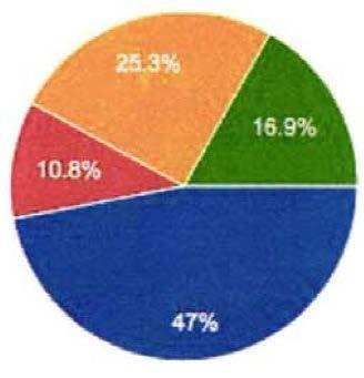
23 If you were able to choose only one, which of the following should be the top priority for improvements to the intersection? 53.6% (126) 7.2% (17) 17.4% (41) 11.1% (26) 3.8% (9) 6.8% (16) (235 total)
24 Estimated CH Travel Times Duluth Ave through TH 13 Top Priority: Moving vehicles through the intersection more quickly and efficiently No Build A1 A2 B1 B2 AM-EB Travel Time PM-EB Travel Time AM-WB Travel Time PM-WB Travel Time

25 Which, if any, of the potential alternatives could you support? A1 A2 B1 B2 (357 total)

26 Which of the potential alternatives could you not support? A1 A2 B1 B2 Can Support Any 11 (264 total)


27 Project Stakeholder Engagement 3 Corridor Visioning Workshops o Vision for Corridor o Roadway Considerations, Downtown Access, Opportunities o Alternatives SWOT Analysis Small Group Meetings o Prior Lake EDA/EDAC Workshop o Prior Lake Rotary Presentation o Talk of the Town Event

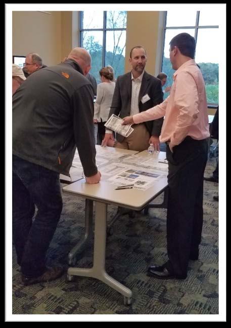
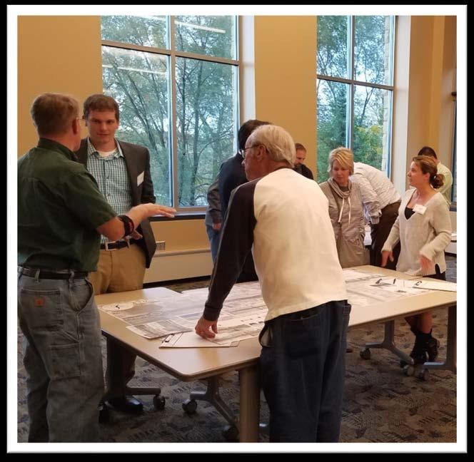
28 Individual Conversations Open House #2 October 10, people signed in 6 Pop-Up Meetings Individual Business Owners

29 SRF/City Council October 16, 2017 Travel Patterns Daily Traffic Volumes Local Roadway Crashes Pedestrian Network, Safety, & Delay Parking Access & Utilization Land Use & Growth Travel Time across Downtown Project Phasing Streetscape Opportunities Property Impacts Local Roadway Assessment

30 SRF/City Council October 16, 2017 Travel Patterns Daily Traffic Volumes Local Roadway Crashes Pedestrian Network, Safety, & Delay Parking Access & Utilization Land Use & Growth Travel Time across Downtown Project Phasing Streetscape Opportunities Property Impacts Local Roadway Assessment
 14.5% of movements will be displaced at Main/CH21 (2,222 of 15,373).")
31 Main Avenue Primary or Secondary? Alternative A-1 (Secondary -Right-in/Right-out) 19.2% of movements will be displaced at Main/CH21 (2,952 of 15,373). Alternative A-2 (Secondary - Half ¾) 14.5% of movements will be displaced at Main/CH21 (2,222 of 15,373). Alternative B-1 (Primary Signal) 60% increase in delay for Main Avenue
32 Main Avenue Primary or Secondary? In the interest of preserving the character of the town, it does not make sense to have one of the main roads in Prior Lake completely pass a road called "Main Street." It is important for local businesses that there continues to be easy access to Main Street. The median will kill all business downtown. I also believe that the Main St negativity is being driven by emotion of several downtown business people. If you ask privately, many business owners do not agree with the few emotional "leaders". Please make a decision that is good for the entire community...current and future! Not super concerned with traffic controls (i.e. right-inright-out) limiting my business. If people want to get to me, they will. Biggest concern is pedestrian travel functioning to allow as much foot travel as possible between downtown businesses.
33 TH 13/CH 21 Operations Signal or Roundabout? Traffic Signal Traffic Operations (2017) Intersection LOS D (40-54 sec/veh.) Traffic Operations (2040) Intersection LOS E (55-79 sec/veh.) 2-3 hours of overall intersection operating at LOS E or worse Roundabout Traffic Operations (2017) Intersection LOS A (0-10 sec/veh.) Traffic Operations (2040) Intersection LOS D (25-34 sec/veh.) AM Intersection LOS B (10-14 sec/veh.) PM 0 hours of overall intersection operating at LOS E or worse The roundabout alternative is expected to better accommodate both local and regional trips at the CH 21 at TH 13 intersection.
34 TH 13/CH 21 Pedestrian Safety Signal or Roundabout? Vehicles traveling at 45 mph, our design speed on TH 13. Probability of Serious Injury Source: AAA Foundation for Traffic Safety (2011)
35 TH 13/CH 21 Pedestrian Safety Signal or Roundabout? Vehicles traveling at 35 mph, our design speed on CH 21. Probability of Serious Injury Source: AAA Foundation for Traffic Safety (2011)
36 TH 13/CH 21 Pedestrian Safety Signal or Roundabout? Vehicles traveling at 20 mph, entrance and exit design speed for a roundabout intersection. Probability of Serious Injury Source: AAA Foundation for Traffic Safety (2011)

37 TH 13/CH 21 A-1 Operations Signal or Roundabout? 2040 PM Peak

38 TH 13/CH 21 A-2 Operations Signal or Roundabout? 2040 PM Peak
39 TH 13/CH 21 B-1 Operations Signal or Roundabout? 2040 PM Peak
40 TH 13/CH 21 Signal or Roundabout? At 13/21 the traffic is just too heavy to be handled by a roundabout. I believe a stoplight at 13 will not work. The state cares only about 13 traffic and will time the light for 13 and 21 will suffer. A roundabout for 13 and 21 would have way too much traffic for that to safely work and the drivers (or at least I) am watching the traffic so much it is hard to see pedestrians. A roundabout is the most efficient way to move traffic through the 13/21 intersection. A traffic light is not. However, it's also the most dangerous for walkers, joggers and cyclists to navigate - even if there are marked crosswalks

41 Multilane Roundabout Lessons Learned Mankato Case Study 1 TH 22 at Madison Avenue in Mankato Daily Traffic Volumes *TH 13/CH 21 currently serves 27,500 VPD and is expected to serve 37,250 VPD in 20 years. Image obtained from Google Maps
42 Multilane Roundabout Lessons Learned Mankato Case Study 1 TH 22 at Madison Avenue in Mankato Traffic Safety Traffic Operations The roundabout has exceeded everyone s expectations for delay reduction. For those that still don t believe roundabouts are a good solution (anywhere) the one thing they can agree on is that they do get (traffic) through the intersections much more quickly than before with the signals. From my observations pre and post construction, we ve created a much more friendly crossing environment for pedestrians. - MnDOT District Traffic Engineer CRASHES PER MONTH *Vehicle crashes have been trending downward in the two years since the opening of the roundabout. No serious injury crashes occurred at the intersection during this time period.

43 Multilane Roundabout Lessons Learned Lakeville Case Study 2 CH 50 (Kenwood Tr) and CH 60 (185 th St) in Lakeville Daily Traffic Volumes *TH 13/CH 21 currently serves 27,500 VPD and is expected to serve 37,250 VPD in 20 years.
44 Multilane Roundabout Lessons Learned Lakeville Case Study 2 CH 50 (Kenwood Tr) and CH 60 (185 th St) in Lakeville Traffic Safety Traffic Operations Traffic Modeling (Opening Day): 4-5 seconds of delay per vehicle expected during peak conditions Field Observations (October 2017) 8-13 seconds of delay per vehicle observed during peak conditions for southbound movement 7-21 seconds of delay per vehicle observed during peak conditions for westbound movement CRASHES PER MONTH *Vehicle crashes have been trending downward since the opening of the roundabout. While 145 crashes occurred in the first year, no serious injuries were observed.
45 Multilane Roundabout Lessons Learned MnDOT Metro Traffic and Central Office 2x1 Roundabout 2x2 Roundabout CH 21 CH 21 TH 13 TH 13 *Images obtained from MnMUTCD

46 Multilane Roundabout Lessons Learned MnDOT Metro Traffic and Central Office 2x1 Roundabout 2x2 Roundabout CH 21! CH 21 TH 13 TH 13 *Images obtained from MnMUTCD

47 Multilane Roundabout Lessons Learned Construction Staging Alternatives Roundabout Under Traffic weeks Full Closure weeks Signal Under Traffic weeks Full Closure weeks TIME-LAPSE CONSTRUCTION VIDEO


48 Next Steps / Decision-Making Process Continue MnDOT Coordination on TH 13 Intersection Control Alternatives Project Management Team Recommendation October 31, 2017 City Council Work Session / Regular Meeting November 6, 2017 Request resolution of support for PMT Recommendation Begin Design and Property Acquisition
BETHEL ROAD AND SEDGWICK ROAD CORRIDOR STUDY
 DRAFT PLAN City Council Meeting August 14, 2017 STUDY AREA Sedgwick Corridor State Route 160, principal arterial with Class 3 access management designation, commuter and freight route, connection to SR
A-1 Arcadia with Signal
 A-1 Arcadia with Signal Dakota St Variation: Half 3/4 with westbound left at Main 4 - Fewer downtown access points - Less efficient traffic operations - Highest project costs vanston. ote: traffic volumes
Tonight is for you. Learn everything you can. Share all your ideas.
 Strathcona Neighbourhood Renewal Draft Concept Design Tonight is for you. Learn everything you can. Share all your ideas. What is Neighbourhood Renewal? Creating a design with you for your neighbourhood.
Chapter 4 Traffic Analysis
 Chapter 4 Traffic Analysis PURPOSE The traffic analysis component of the K-68 Corridor Management Plan incorporates information on the existing transportation network, such as traffic volumes and intersection
City of Sammamish. Welcome. Issaquah-Fall City Road Improvements Project Phase I Design: 242nd Avenue SE to Klahanie Drive SE
 Welcome Welcome to the third community meeting for the Issaquah-Fall City Road Improvements Project. AGENDA 6:00 p.m. Welcome and sign-in 6:10 p.m. Presentation 6:50 p.m. Open house Learn about the roadway
CITY OF FRANKLIN, TENNESSEE. Columbia Avenue. Widening & Improvements Project. Public Meeting May 16, 2017
 CITY OF FRANKLIN, TENNESSEE Columbia Avenue Widening & Improvements Project Public Meeting May 16, 2017 Agenda 6:00 6:30 Formal Presentation 6:30 8:00 Town Hall Forum City of Franklin Columbia Avenue Alternatives
Intersection Improvement: Sturgeon Road, Silver Avenue and Murray Park Road Roundabout. Welcome. Public Information Session
 Intersection Improvement: 1 Welcome WHY IS AN INTERSECTION IMPROVEMENT NEEDED? 2 Traffic volumes for Sturgeon Road, Silver Avenue and Murray Park Road exceed the capacity of the existing 4-way stop controlled
Governance and Priorities Committee Report For the July 2, 2015 Meeting
 CITY OF VICTORIA For the July 2, 2015 Meeting To: Governance and Priorities Committee Date: From: Subject: Brad Dellebuur, A/Assistant Director, Transportation and Parking Services Executive Summary The
Project Report. South Kirkwood Road Traffic Study. Meadows Place, TX October 9, 2015
 Meadows Place, TX October 9, 2015 Contents 1 Introduction... 1 2 Data Collection... 1 3 Existing Roadway Network... 2 4 Traffic Volume Development... 2 5 Warrant Analysis... 3 6 Traffic Control Alternative
A CHANGING CITY. of Edmonton, it is essential that it reflects the long-term vision of the City.
 A CHANGING CITY By the year 2040, Edmonton will be home to more than 1 million people. To accommodate growth and support a healthy and compact city, we need a new approach to development/redevelopment
Albany Shaker Road Corridor Study Public Meeting # 2
 Albany Shaker Road Corridor Study Public Meeting # 2 Scope / Meeting Purpose This project is a CDTC Linkage Study. The Linkage Program is designed to implement the adopted planning and investment principles
Blair/Williamson Intersection Expressed Needs
 Blair/Williamson Intersection Expressed Needs NORTH Blair Street is a barrier for pedestrians and bicycles Relocate Capitol City Trail crossing from Blair Street and John Nolen Drive intersection to Williamson
TRANSPORTATION ANALYSIS REPORT US Route 6 Huron, Erie County, Ohio
 TRANSPORTATION ANALYSIS REPORT US Route 6 Huron, Erie County, Ohio December 12, 2012 Prepared for: The City of Huron 417 Main Huron, OH 44839 Providing Practical Experience Technical Excellence and Client
ALLEY 24 TRAFFIC STUDY
 ALLEY 24 TRAFFIC STUDY in City of Frostburg, Maryland January 2013 3566 Teays Valley Road Hurricane, WV Office: (304) 397-5508 www.denniscorporation.com Alley 24 Traffic Study January 2013 Frostburg, Maryland
I-95/Temple Avenue Improvements Project Colonial Heights, VA
 I-95/Temple Avenue Improvements Project Colonial Heights, VA Pardon Our Dust Informational Meeting February 3, 2016 Harold Dyson, P.E. Construction Manager, Richmond District Tom Heil, P.E. Allan Myers
KING STREET TRANSIT PILOT
 STREET TRANSIT PILOT Update toronto.ca/kingstreetpilot #kingstreetpilot HIGHLIGHTS PREVIOUS HIGHLIGHTS TRANSIT RELIABILITY TRANSIT TRAVEL TIMES 85% of streetcars arriving within 4 minutes westbound during
INNOVATIVE INTERSECTION DESIGN
 INNOVATIVE INTERSECTION DESIGN J. Eddie Valtier, P.E. ELP TP&D Director Introduction Why Do We Need To Start Looking For Innovative Intersection Designs? Congestion is worsening and traffic volumes and
Shockoe Bottom Preliminary Traffic and Parking Analysis
 Shockoe Bottom Preliminary Traffic and Parking Analysis Richmond, Virginia August 14, 2013 Prepared For City of Richmond Department of Public Works Prepared By 1001 Boulders Pkwy Suite 300, Richmond, VA
Report Purpose To seek Council s approval of the Wye Road Functional Planning Study (January 2015).
.") COUNCIL MEETING Meeting Date: March 10, 2015 Agenda Item #: 13.1 Wye Road Functional Planning Study (January 2015) Report Purpose To seek Council s approval of the Wye Road Functional Planning Study (January
COUNCIL MEETING Meeting Date: March 10, 2015 Agenda Item #: 13.1 Wye Road Functional Planning Study (January 2015) Report Purpose To seek Council s approval of the Wye Road Functional Planning Study (January
League City Parkway at Brittany Lakes/Fennigan Intersection Evaluation/ Traffic Study. Second Public Meeting February 6, 2018
 League City Parkway at Brittany Lakes/Fennigan Intersection Evaluation/ Traffic Study Second Public Meeting February 6, 2018 City Project Information League City Parkway and Brittany Lakes Dr./ Fennigan
Thank you for attending
 Improving mobility safety comfort WELCOME Thank you for attending The purpose of this meeting is to: Learn about the project Prioritize potential walking and biking improvements on Snelling Ave Gather
122 Avenue: 107 Street to Fort Road
 : 107 Street to Fort Road November 24, 2015 4:30 8:00 p.m. Meeting Purpose Summarize project work completed to date Share results of public input from Phase 1 Share the draft concept plan and proposed
Access Management Regulations and Standards
 Access Management Regulations and Standards January 2014 Efficient highway operation Reasonable property access Concept of Access Management The way to manage access to land development while preserving
AGENDA REPORT. Issue: Discussion of potential improvements on Barnwell Road at Niblick Drive
 AGENDA REPORT To: From: By: Honorable Mayor and City Council Members Warren Hutmacher, City Manager Tom Black, Public Works Director Date: March 23, 2016 Agenda: March 28, 2016 WORK SESSION AGENDA: Barnwell
50 Avenue S.W. Corridor Study Glenmore Aquatic Centre Drop-In Event
 Project overview The City of Calgary is conducting a transportation corridor study of 5 Avenue S.W., between Crowchild Trail and 4A Street S.W. In 29, it was reclassified as a Parkway under the Calgary
HIGHBURY AVENUE/HAMILTON ROAD INTERSECTION IMPROVEMENTS PUBLIC INFORMATION CENTRE 1 MAY 14, 2015
 HIGHBURY AVENUE/HAMILTON ROAD INTERSECTION IMPROVEMENTS Municipal Class Environmental Assessment PUBLIC INFORMATION CENTRE 1 MAY 14, 2015 ACCESSIBILITY Under the Accessibility Standards 2015 for Customer
PROJECT OVERVIEW. 20th Avenue Project Limits (Lincoln Way to Wawona St)
") PROJECT OVERVIEW In 2014, San Francisco adopted Vision Zero as City policy, with a commitment to eliminate all traffic deaths in the City by 2024. nue Project Limits (Lincoln Way to St) Collision data
PROJECT OVERVIEW In 2014, San Francisco adopted Vision Zero as City policy, with a commitment to eliminate all traffic deaths in the City by 2024. nue Project Limits (Lincoln Way to St) Collision data
Evaluation of M-99 (Broad Street) Road Diet and Intersection Operational Investigation
 Road Diet and Intersection Operational Investigation") Evaluation of M-99 (Broad Street) Road Diet and Intersection Operational Investigation City of Hillsdale, Hillsdale County, Michigan June 16, 2016 Final Report Prepared for City of Hillsdale 97 North Broad
Evaluation of M-99 (Broad Street) Road Diet and Intersection Operational Investigation City of Hillsdale, Hillsdale County, Michigan June 16, 2016 Final Report Prepared for City of Hillsdale 97 North Broad
Carmel, Indiana Illinois Street and 126th Street Westfield Boulevard and 96th Street Arts and Design District RAB
 Sustainability Benefits Of Network Wide Roundabout Use Case Study of Carmel, Indiana Presented By: Michael McBride PE Carmel City Engineer Carmel, Indiana Carmel, Indiana 1996 Carmel, Indiana Population
Public Information Meeting. Warren County Pathway Corridor Project September 27, 2018
 Public Information Meeting Warren County Pathway Corridor Project September 27, 2018 Why are we here? Introduce Study Hear concerns and Ideas Obtain input on preliminary Alternatives Previous Study (2008)
Fields of St. Croix HOA Meeting. October 27, 2016
 Fields of St. Croix HOA Meeting October 27, 2016 Welcome! Why are we here? Update on Manning Avenue Phase 2 Project: Project Design Schedule Project Background Importance of Manning Avenue: Primary north-south
CITY OF SPOKANE VALLEY Request for Council Action
 CITY OF SPOKANE VALLEY Request for Council Action Meeting Date: December 16, 2014 Department Director Approval: Check all that apply: consent old business new business public hearing information admin.
MINERAL AVENUE CORRIDOR ASSESSMENT STUDY IMPLEMENTATION STRATEGY
 MINERAL AVENUE CORRIDOR ASSESSMENT STUDY IMPLEMENTATION STRATEGY INTRODUCTION City Personnel Sign-in Sheet Comment Forms Please Write Down Any Feedback INTRODUCTION List of Topics for Presentation Study
WISCONSIN AVENUE EXTENSION SECOND PUBLIC INFORMATION MEETING. March 28, 2017
 WISCONSIN AVENUE EXTENSION SECOND PUBLIC INFORMATION MEETING March 28, 2017 STUDY AREA N MEETING AGENDA Introductions Study Background Alternatives Studied Recommended Alternative Discussion STUDY BACKGROUND
STONY PLAIN ROAD STREETSCAPE
 Jasper Place Revitalization Strategy: Vision The people involved in the Jasper Place Revitalization Strategy envision: Goal 1: Feeling safe in our community Create a community where feeling safe is common--where
Title Option One. Operations and Safety of Separated Bicycle Facilities at Single Lane Roundabouts
 Title Option One Operations and Safety of Separated Bicycle Facilities at Single Lane Roundabouts David Stanek, PE Institute of Transportation Engineers Western District Annual Meeting San Diego, CA June
Access Management Regulations and Standards
 Access Management Regulations and Standards Efficient highway operation Reasonable property access Concept of Access Management The way to manage access to land development while simultaneously preserving
City of Wausau Wausau Center Urban Design and Transportation Master Plan. Design Workshop // October 18, 2018
 City of Wausau Wausau Center Urban Design and Transportation Master Plan Design Workshop // October 18, 2018 Design Workshops // October 15-18 Workshop Study Evaluate circulation and parking patterns around
Feasibility Study of Pedestrian Crossings Along Route 7, East of Cascades Parkway and West of Dranesville Road. October 3, 2017
 Feasibility Study of Pedestrian Crossings Along Route 7, East of Cascades Parkway and West of Dranesville Road October 3, 2017 Study Area (area within a ¼-mile radius of the study intersections) Route
Wyldewood Estates. Pre-Application Public Engagement Summary of Issues and Responses
 Wyldewood Estates Pre-Application Public Engagement Summary of Issues and Responses March 2016 Executive Summary Morguard Residential Properties has been thoughtfully planning the redevelopment of Wyldewood
Lincoln Avenue Road Diet Trial
 Lincoln Avenue Road Diet Trial Data Collection Report June 1, 2015 Department of Transportation Table of Contents I. Introduction...... 3 II. Data Collection Methodology & Results...... 5 A. Traffic Volume
BOERNE/KENDALL COUNTY TRANSPORTATION FORUM. March 22, 2018
 BOERNE/KENDALL COUNTY TRANSPORTATION FORUM March 22, 2018 Frontage Road Operational Improvements 2 Frontage Roads Under Construction Fair Oaks Pkwy to Dominion I-10 - Fair Oaks Pkwy to FM 3351 Scope: Convert
Roundabout Evaluations in Virginia: US 15/US 50 Gilberts Corner, VA SR 106/SR 634 Prince George County, VA
 Roundabout Evaluations in Virginia: US 15/US 50 Gilberts Corner, VA SR 106/SR 634 Prince George County, VA VDOT & FHWA Roundabout Workshop September 17, 2013 Chris Tiesler, PE Presentation Outline US 15/US
Welcome! San Jose Avenue Open House August 25, 2015
 Welcome! San Jose Avenue Open House August 25, 2015 Vision Zero The City and County of San Francisco adopted Vision Zero San Francisco Vision Zero High Injury Network as a policy in 2014, committing an
TRAFFIC STUDY. Birch Bluff Road / Pleasant Avenue 01/15/2018. City of Tonka Bay 4901 Manitou Road Tonka Bay, MN WSB PROJECT NO.
 TRAFFIC STUDY Birch Bluff Road / Pleasant Avenue 01/15/2018 City of Tonka Bay 4901 Manitou Road Tonka Bay, MN 55331 WSB PROJECT NO. 10805-000 Birch Bluff Road/ Pleasant Avenue Traffic Study For: City of
Existing Conditions. Date: April 16 th, Dan Holderness; Coralville City Engineer Scott Larson; Coralville Assistant City Engineer
 Date: April 16 th, 2015 To: From: Re: Dan Holderness; Coralville City Engineer Scott Larson; Coralville Assistant City Engineer Darian Nagle-Gamm, Traffic Engineering Planner Highway 6 (2 nd Street) /
January 31, Woodrow Wilson Small Area Study
 Woodrow Wilson Small Area Study Overview Woodrow Wilson Complex Consists of: Wilson Elementary School Valley Career and Technical Center Wilson Middle School Wilson High School Wilson Workforce and Rehabilitation
WELCOME. Stakeholder Involvement Group Meeting #2 Round Lake Public Works October 24, 2018
 WELCOME Stakeholder Involvement Group Meeting #2 Round Lake Public Works October 24, 2018 MEETING AGENDA 1. Welcome and Introductions 2. Study Progress Update 3. Problem Statement 4. Technical Analysis
Presentation Outline. Project/Study Purpose. Existing Conditions. Future Conditions. Understanding the Streetside. Similar Walkable Environments
 Presentation Outline Project/Study Purpose Study Area Map Existing Conditions Future Conditions Understanding the Streetside Similar Walkable Environments Conceptual Alternatives Magnolia/NE 1st Ave Block
City of Moorhead Committee of the Whole Meeting
 City of Moorhead Committee of the Whole Meeting Corridor Study Limits Center Avenue (Red River to 8th Street) TH 10 (Red River to TH 336) TH 75 (20th Ave S to Main Avenue) 2 Study Need: Project Overview
Reference number /VP. Lafayette Downtown Congestion Study - Additional Traffic Analysis
 To James Hinkamp and Tony Coe, City of Lafayette Date January 19, 2017 Copies Reference number 243381/VP From Michael Iswalt and Vanessa Peers File reference 4-05 Subject Lafayette Downtown Congestion
Miami Health District
 Miami Health District Streetscapes, Gateways, and Signage Basis of Design Report Study Miami Partnership Meeting July 21, 2008 Gannett Fleming EDAW The Corradino Group Sponsored by the Miami Partnership:
Comments EXECUTIVE SUMMARY
 Comments 1. Under any Alternatives, MCDOT should provide better at-grade pedestrian crossing of Georgia Avenue and Forest Glen Road, including improved crosswalks with wider medians and adequate signal
Summary: Mercer County Princeton Avenue & Spruce Street Study January 2009
 Summary: Several recent studies have assessed potential development and redevelopment opportunities in the Mercer Crossing area of Trenton, Ewing, and Lawrence. This Princeton Avenue and Spruce Street
Bus Rapid Transit Plans
 Twin Cities Region Bus Rapid Transit Plans ULI Minnesota Workshop Connecting Bus Rapid Transit to the Community December 15, 2009 John Levin Director of Service Development Metro Transit Metropolitan Area
GARLAND ROAD/GASTON AVENUE/ GRAND AVENUE INTERSECTION IMPROVEMENT STUDY
 MEETING OF AFFECTED PROPERTY OWNERS AND STAKEHOLDERS GARLAND ROAD/GASTON AVENUE/ GRAND AVENUE INTERSECTION IMPROVEMENT STUDY CSJ 0009-02-067 Meeting Agenda 1 2 3 4 5 6 7 8 9 10 Opening Remarks State Representative
Conversion of One-Way Couplet Streets to Two-Way
 Conversion of One-Way Couplet Streets to Two-Way May 5, 2016 Oklahoma Traffic Engineers Association 2016 Spring Meeting, Tulsa, OK Kevin St. Jacques, P.E., PTOE, PTP Freese and Nichols Overview Initial
Monterey Road Complete Streets
 Monterey Road Complete Streets Complete Street Objectives Improve livability and economic vitality Enhance pedestrian environment Accommodate bicyclists safely Reduce noise and air pollution Create attractive,
Balancing Operation & Safety for Motorized and Non-Motorized Traffic
 Balancing Operation & Safety for Motorized and Non-Motorized Traffic Brian Willham, PE, PTOE Iowa Director - MOVITE June 30, 2014 Learning Objectives: When & Why should we measure the performance of complete
Design Public Hearing MassDOT Project # February 19, 2015 Chatham Town Hall Annex 7:00 P.M.
 Design Public Hearing MassDOT Project #606596 February 19, 2015 Chatham Town Hall Annex 7:00 P.M. Overview Process to date Project goals Data collection results Existing conditions Alternative analysis
CONTENTS EXECUTIVE SUMMARY 1
 CONTENTS CHAPTER PAGE EXECUTIVE SUMMARY 1 1 ISSUES AND PURPOSE OF THE ANALYSIS 2 1.1 Background 2 1.2 Analysis Area 2 1.3 Issues and Observations 3 1.4 Project and Public Meetings 3 2 LIST OF PREFERRED
Scarlett Road Bridge & Road Improvements Lambton Park Community School - Gymnasium Tuesday November 28 th, 2017
 Scarlett Road Bridge & Road Improvements Lambton Park Community School - Gymnasium Tuesday November 28 th, 2017 PROJECT LOCATION 2 SCARLETT ROAD BRIDGE Constructed in 1912, the bridge carries 4 active
Highway 49, Highway 351 and Highway 91 Improvements Feasibility Study Craighead County
 Highway 49, Highway 351 and Highway 91 Improvements Feasibility Study Craighead County Executive Summary March 2015 Highway 49, Highway 351 and Highway 91 Improvements Feasibility Study Craighead County
Walmart (Store # ) 60 th Street North and Marion Road Sioux Falls, South Dakota
 60 th Street North and Marion Road Sioux Falls, South Dakota") Walmart (Store #4865-00) 60 th Street North and Marion Road Sioux Falls, South Dakota Prepared for: Wal-Mart Stores, Inc. Bentonville, Arkansas Prepared by: Kimley-Horn and Associates, Inc. ã2013 Kimley-Horn
Walmart (Store #4865-00) 60 th Street North and Marion Road Sioux Falls, South Dakota Prepared for: Wal-Mart Stores, Inc. Bentonville, Arkansas Prepared by: Kimley-Horn and Associates, Inc. ã2013 Kimley-Horn
Maywood Town Hall Meeting. May 4, 2016
 Maywood Town Hall Meeting May 4, 2016 1 AGENDA Overall I-290 Study Background Maywood Advisory Working Group (AWG) findings to date Noise Wall Update Next Steps 2 Questions? Study team members also available
CIRCLE DRIVE TRAFFIC AND ACCESS MANAGEMENT POLICY GUIDE. Management Principles and Implementation Concepts
 CIRCLE DRIVE TRAFFIC AND ACCESS MANAGEMENT POLICY GUIDE A. PREFACE Management Principles and Implementation Concepts The intent of this policy guide is to provide interim guidance on the implementation
Bay to Bay Boulevard Complete Streets Project
 Bay to Bay Boulevard Complete Streets Project Dale Mabry Highway to Bayshore Boulevard February 08, 2018 Photo Source: Tampa Bay Times Alessandra Da Pra Meeting Format Introduction Resurfacing Information
CITY OF CAMBRIDGE 2015 BICYCLE PLAN TOWARDS A BIKABLE FUTURE
 CITY OF CAMBRIDGE 2015 BICYCLE PLAN TOWARDS A BIKABLE FUTURE WHICH FUTURE? CAMBRIDGE MUNICIPAL POLICIES 1992: Vehicle Trip Reduction Ordinance 1998: Parking & Transportation Demand Ordinance 2002: Climate
Town of Bethlehem. Planning Assessment. Bethlehem Town Board
 Town of Bethlehem US 9W Corridor Transportation Planning Assessment Presented e to: Bethlehem Town Board June 2009 Overview Study Background Route 9W Corridor Conditions and Improvements Selkirk Bypass
MEMORANDUM. Earl Haugen and UND Transportation and Traffic Coordination Committee
 SRF No. 7766 MEMORANDUM TO: FROM: Earl Haugen and UND Transportation and Traffic Coordination Committee Rick Lane, P.E. DATE: November 26, 2013 SUBJECT: UNIVERSITY AVE REVIEW Our review of the University
THE ALAMEDA CONCEPT DESIGN COMMUNITY MEETING 3. A Plan for The Beautiful Way JANUARY 28, 2010
 CONCEPT DESIGN COMMUNITY MEETING 3 JANUARY 28, 2010 AGENDA INTRODUCTION COMMUNITY INPUT ROADWAY STUDIES STREETSCAPE DESIGN STATIONS DISCUSSION SUMMARY AND DISCUSSION NEXT STEPS CLOSE INTRODUCTION SCHEDULE
North Shore Transportation Improvement Strategy
 North Shore Transportation Improvement Strategy Preliminary, Near-term Recommendation 2016 April Transportation Improvement Strategy (TIS) Comprehensive and Analytical A multi-modal transportation strategy
Corridor Vision Workshop Summary James Madison Elementary February 22,2018
 Corridor Vision Workshop Summary James Madison Elementary February 22,2018 WHY DEVELOP THIS STUDY? Ogden City is planning for better connectivity and access to jobs and housing. Working with area partners,
PRELIMINARY DRAFT WADDLE ROAD / I-99 INTERCHANGE PROJECT ALTERNATIVE ANALYSIS FINAL TRAFFIC SUMMARY REPORT
 PRELIMINARY DRAFT WADDLE ROAD / I-99 INTERCHANGE PROJECT ALTERNATIVE ANALYSIS FINAL TRAFFIC SUMMARY REPORT Prepared by: In Association with: November 2013 EXECUTIVE SUMMARY Patton Township, in partnership
Southview Blvd & 3 rd Avenue Improvement Project. Public Open House December 4, to 7pm
 Southview Blvd & 3 rd Avenue Improvement Project Public Open House December 4, 2014 5 to 7pm Southview Blvd & 3 rd Avenue Public Information Meeting Agenda Presentation 5:30 to 6:15 pm Purpose of Project
Project Goal and Description. Why Broadway? Broadway SFMTA.COM/BROADWAY. The goal of the Broadway Safety Improvement
 PROJECT OVERVIEW Project Goal and Description The goal of the Broadway Safety Improvement d St Van Ness Ave Project is to improve safety and comfort for all who Franklin St Hyde St Octavia St Gough St
Gene Dillon Elementary School Traffic Study Division Street Site
 To: From: Dr. James Hess, Superintendent Jordan Schwarze, PE, Senior Engineer Matt Pacyna, PE, Senior Associate Date: March 30, 2016 Subject: Gene Dillon Elementary School Traffic Study reet Site Memorandum
Vehicular and Pedestrian Access to Herndon Metrorail Station. Robert B. Boxer, Director John Stuart, Clark Nexen October 28, 2015
 Vehicular and Pedestrian Access to Herndon Metrorail Station Robert B. Boxer, Director John Stuart, Clark Nexen Project Location The project is located in the Town of Herndon along Herndon Parkway between
City of Davis East Covell Corridor Plan
 Community Open House #2 January 22, 2014 6:00 8:00 p.m. Veterans Memorial Center, Club Room City of Davis Introduction The (ECCP) is a taking a comprehensive look at the existing transportation systems
WELCOME Public Information Centre
 WELCOME Public Information Centre Fernforest Drive Brampton Soccer Centre Community Room #2 Tuesday January 19, 2016 6:30 p.m.to 9:00 p.m. Please sign in Neighbourhood Traffic Calming Guide Background
Harrah s Station Square Casino
 Transportation Analysis Harrah s Station Square Casino Pittsburgh, Pennsylvania Submitted To: City of Pittsburgh and Pennsylvania Gaming Control Board Prepared By: DKS Associates GAI Consultants December
DOWNTOWN TUPELO MAIN STREET: ROAD DIET STUDY
 DOWNTOWN TUPELO MAIN STREET: ROAD DIET STUDY Since mid-2009, RPM Transportation Consultants (RPM) has worked with the Downtown Tupelo Main Street Association to evaluate traffic conditions and potential
MoPac South: Impact on Cesar Chavez Street and the Downtown Network
 MoPac South: Impact on Cesar Chavez Street and the Downtown Network Prepared by: The University of Texas at Austin Center for Transportation Research Prepared for: Central Texas Regional Mobility Authority
Left Turn Queue Box and Bike Lane Door Zone Hatching Performance Singletree Drive Columbus, Ohio
 Left Turn Queue Box and Bike Lane Door Zone Hatching Performance 6612 Singletree Drive Columbus, Ohio 43229 614.656.2424 www.cmtran.com Columbus, Ohio Installations Turn Box Columbus, Ohio Installations
YELLOWHEAD TRAIL / 149 STREET INTERCHANGE
 YELLOWHEAD TRAIL / 149 STREET INTERCHANGE WELCOME Today we are introducing the concept planning project for a new gradeseparated interchange at Yellowhead Trail and 149 Street PURPOSE Provide information
VT15 / Allen Martin Drive Intersection Scoping Study
 VT15 / Allen Martin Drive Intersection Scoping Study ALTERNATIVES PRESENTATION MEETING DECEMBER 19, 2016 Agenda Study Area Project Background Existing Conditions Identified Issues Proposed Alternatives
TRANSPORTATION FACILITY PLANNING Waugh Chapel Road Maytime Drive to New Market Lane
 July 24, 2018 TRANSPORTATION FACILITY PLANNING Waugh Chapel Road Maytime Drive to New Market Lane DPWandYOU.com Making a difference, together Meeting Agenda Purpose of the project Overview of work conducted
Living Streets Policy
 Living Streets Policy Introduction Living streets balance the needs of motorists, bicyclists, pedestrians and transit riders in ways that promote safety and convenience, enhance community identity, create
City of Gainesville Transportation/Roadway Needs PROJECT SUMMARY
 A1 Roadway Resurfacing $23,846,000 TYPE: Preservation of existing system Roadway resurfacing A2 Signal Replacement $6,000,000 TYPE: Preservation of existing system Replace traffic signals. B1 W 6th St
Queensboro Bridge Bus Priority Study: Summary of Recommendations. Presentation to Manhattan Community Board 8 May 4, 2011
 : Summary of Recommendations Presentation to Manhattan Community Board 8 May 4, 2011 1 Overview Study Goal: Identify cost-effective ways to improve bus speed and reliability for local and express buses
Traffic Impact Study WestBranch Residential Development Davidson, NC March 2016
 Traffic Impact Study WestBranch Residential Development Davidson, NC March 216 TRAFFIC IMPACT STUDY FOR THE WestBranch Residential Development LOCATED IN DAVIDSON, NC Prepared For: Lennar Carolinas, LLC
SH-6 Corridor Improvement Study Policy Committee Progress Report M O N D AY, J U N E 1 0, B R A Z O S C E N T E R
 SH-6 Corridor Improvement Study Policy Committee Progress Report M O N D AY, J U N E 1 0, 2 0 1 3 B R A Z O S C E N T E R Project Overview Study Goals and Objectives» Improve traffic flow» Reduce delay»
TRAFFIC IMPACT STUDY COMPREHENSIVE UPDATE TOWN OF THOMPSON S STATION, TENNESSEE PREPARED FOR: THE TOWN OF THOMPSON S STATION
 TRAFFIC IMPACT STUDY COMPREHENSIVE UPDATE TOWN OF THOMPSON S STATION, TENNESSEE PREPARED FOR: THE TOWN OF THOMPSON S STATION Transportation Consultants, LLC 1101 17 TH AVENUE SOUTH NASHVILLE, TN 37212
Project Update May 2018
 Project Update May 2018 Dakota County, in cooperation with the City of Lakeville, is planning to reconstruct 202 nd Street West (County Road 50) from Holyoke Avenue to Cedar Avenue (County Road 23). 202
CITY OF OAKLAND. 27th Street Bikeway Feasibility and Design. Final Report (v3) March 23, Kimley-Horn and Associates, Inc.
 March 23, Kimley-Horn and Associates, Inc.") CITY OF OAKLAND 27th Street Bikeway Feasibility and Design Final Report (v3) March 23, 2007 PREPARED BY: Kimley-Horn and Associates, Inc. Table of Contents 1. Introduction 3 2. 27 th Street/Bay Place Corridor
CITY OF OAKLAND 27th Street Bikeway Feasibility and Design Final Report (v3) March 23, 2007 PREPARED BY: Kimley-Horn and Associates, Inc. Table of Contents 1. Introduction 3 2. 27 th Street/Bay Place Corridor
Arterial Management Plan for US Route 250 and State Route 623
 Arterial Management Plan for US Route 250 and State Route 623 June 25, 2014 Brad Shelton, AICP Access Management and Traffic Impact Analysis Programs Manager Transportation and Mobility Planning Division
TRANSPORTATION & MOBILITY
 TRANSPORTATION & MOBILITY ROADWAY SYSTEM There are approximately 40 miles of roadways in Manitou Springs. For planning purposes, roadways are typically assigned a functional classification which defines
CITY OF COCOA BEACH 2025 COMPREHENSIVE PLAN. Section VIII Mobility Element Goals, Objectives, and Policies
 CITY OF COCOA BEACH 2025 COMPREHENSIVE PLAN Section VIII Mobility Element Goals, Objectives, and Policies Adopted August 6, 2015 by Ordinance No. 1591 VIII MOBILITY ELEMENT Table of Contents Page Number
Figure 1: Vicinity Map of the Study Area
 ARIZONA TEXAS NEW MEXICO OKLAHOMA May 5, 2016 Mr. Anthony Beach, P.E. BSP Engineers 4800 Lakewood Drive, Suite 4 Waco, Texas 76710 Re: Intersection and Access Analysis along Business 190 in Copperas Cove
WHANGAREI IMPROVEMENTS
 WHANGAREI IMPROVEMENTS PROJECT OVERVIEW The NZ Transport Agency (NZTA) is working with Whangarei District Council (WDC) to improve the state highway through Whangarei. In addition to the recently completed