Left Turn Queue Box and Bike Lane Door Zone Hatching Performance Singletree Drive Columbus, Ohio
|
|
|
- Ronald Leonard
- 5 years ago
- Views:
Transcription


1 Left Turn Queue Box and Bike Lane Door Zone Hatching Performance 6612 Singletree Drive Columbus, Ohio

2 Columbus, Ohio Installations Turn Box

3 Columbus, Ohio Installations Turn Box

4 Columbus, Ohio Hatch


5 What is a Two-Stage Left Turn Queue Box?

6 How to Use a Turn Queue Box Right Turn on Red restrictions at select intersections
7
8 Transverse Markings Evaluation Provides a barrier between cyclists and parked vehicles Encroaching cyclists and length of encroachment was evaluated


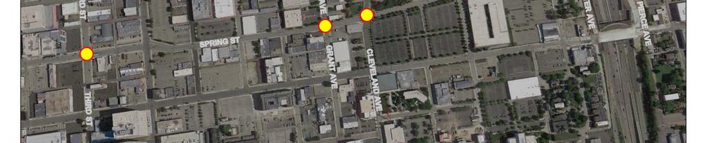
9 Right Turn on Red Compliance Evaluation of driver compliance with right turn on red restrictions Evaluated driver performance on approaches with turn queue boxes present Each study intersection had different type of restriction Spring & Elijah Pierce No RTOR When Bike Present Spring & Lester No RTOR Except Curb Lane Spring & Grant No RTOR Images from Google Street View

10 Data Collection 6 Collection Periods 24 hours of video per intersection Collection Schedule 1: Before Installation 2: Immediately After Installation 3: One Month After Installation 4: Three Months After Installation 5: Nine Months After Installation 6: Twelve Months After Installation Installation Delays Schedule Changes
11 Data Collection

12 Evaluation Conflict Rates Compliance Rates Right Turn on Red Compliance Transverse Markings Evaluation Noted Observations Many Iterations of Analysis
13 Number of Cyclists Counted in 24 Hours on Turn Queue Box Approaches Collection Total Cyclists Counted on all Intersection Approaches with a Turn Queue Box Highest Volume Lowest Volume Median of all Counts Average of all Counts Collection 1 1, Collection 2 1, Collection 3 1, Collection 4 2, Collection 5 2, Collection 6 1,
14 Results & Trends

15 Results & Trends
16 Results & Trends
17 Results & Trends

18 Results & Trends
19 Right Turn on Red Compliance Spring & Elijah Pierce No RTOR When Bike Present Spring & Lester No RTOR Except Curb Lane Spring & Grant No RTOR


20 Anecdotal Observations for Turn Queue Box Evaluation Better Turn Box usage takes place Downtown rather than north OSU Campus area Joggers use bike lanes Most conflict comes from cyclists using sidewalk & quickly changing lanes in roadway Very minimal conflicts with actual use of turn queue boxes Cyclists take fastest path from A to B Seattle, WA

21 Transverse Markings Evaluation Transverse Markings Cyclist Count Data
22 Transverse Markings Evaluation Transverse Markings Encroachers & Lengths of Encroachment
23 General Results Turn Queue Box Evaluation Overall Compliance 73.8% Overall Conflict 2.1% Turn Box Approach Compliance 85.4% Turn Box Approach Conflict 1.2% 4.3% of total cyclists made turn queue box movement Of the 4.3% above, 21.6% of those cyclists utilized the turn queue box RTOR Compliance Overall Right Turn on Red Compliance 97.0% Transverse Marking Evaluation 13.6% of all cyclists encroached Encroachment occurred for average of 40.8% of observable length

24 Conclusions Low Turn Queue Box Utilization Initial dip in utilization but then trend is up Low total vehicle volumes at intersections Comfort level Additional time Sidewalks/Crosswalks Utilization likely to increase as Columbus traffic volumes grow N. 4 th Street & E. Long Street Columbus, OH

25 Conclusions Positive Turn Box Impacts Reduction in Conflicts on turn box approaches Trending towards even less conflicts Increase in compliance on turn box approaches No noticeable issues with driver behavior Compliance trending upward Sidewalk use trending down Effects of bike lanes + turn queue boxes


26 Conclusions Transverse Markings Benefit Number of cyclists encroaching in hatch trending down Right turn on Red compliance Good and trending upward Limited data

27 Recommendations Turn Queue Box education for drivers and cyclists Further evaluation as Columbus traffic volumes continue to grow
28 What could we have done differently? Evaluation of weather/time of year on results Evaluation of bike lane installation prior to turn queue box installation
29 QUESTIONS?
Bicycle Facilities Planning
 Bicycle Facilities Planning Overview Types of Cyclists Purpose for Riding Types of Facilities Bike Lanes Bicycle Boulevards Cycle Tracks Intersections Signals Signing and Marking Discussion Types of Bicyclists
Sharrows and Elephants and Bike Boxes!, s, Oh My!
 Sharrows and Elephants and Bike Boxes!, s, Oh My! New Traffic Control Devices on Vancouver s Bike Routes David Rawsthorne, P.Eng. City of Vancouver Engineering g Services CITE Quad Conference, May 2009
Cycle Track Design Best Practices Cycle Track Sections
 Design Best Practices Sections It is along street segments where the separation and protection methods of cycle tracks offer more comfort than conventional bicycle lanes, and are more attractive to a wide
2014/2015 BIKE ROUTE PLAN 83 AVENUE PROTECTED BIKE LANE
 About the Project The City of Edmonton is planning a major bike route on the southside of Edmonton. The Strathcona Bike Route will connect the communities of Strathcona, Garneau and the University area,
Intersection Improvement: Sturgeon Road, Silver Avenue and Murray Park Road Roundabout. Welcome. Public Information Session
 Intersection Improvement: 1 Welcome WHY IS AN INTERSECTION IMPROVEMENT NEEDED? 2 Traffic volumes for Sturgeon Road, Silver Avenue and Murray Park Road exceed the capacity of the existing 4-way stop controlled
Major Bike Routes 102 Avenue Workshop April 21, 2015
 Major Bike Routes 102 Avenue Workshop April 21, 2015 Our Purpose Today Provide context on how Major Bike Routes fit into Edmonton s future Share information on what we heard in our last phase, and how
Clybourn Ave. Protected Bike Lane Study Halsted St. to Division St.
 Clybourn Ave. Protected Bike Lane Study Halsted St. to Division St. Nathan Roseberry, Senior Engineer Pam Broviak, Project Manager July 24, 2014 Agenda Project Goals Existing Roadway Conditions Traffic
Broad Street Bicycle Boulevard Design Guidelines
 Broad Street Bicycle Boulevard Design Guidelines Building from the strategies introduced in the 2013 Bicycle Transportation Plan and community input received thus far, City Transportation Staff have identified
Active Transportation Facility Glossary
 Active Transportation Facility Glossary This document defines different active transportation facilities and suggests appropriate corridor types. Click on a facility type to jump to its definition. Bike
Raymond Avenue: Rightsizing Improved Safety and Pedestrian Experience
 Page 1 of 5 Work With Us Free Newsletter Stay Connected Home About Services Training Projects Placemaking Blog Resources Reference Store Great Public Spaces Image Collection Raymond Avenue: Rightsizing
Copenhagen Cycling Map. Red Lines Cycling facilities
 Copenhagen Cycling Map Red Lines Cycling facilities Copenhagen Cycling Facilities Design Approaches Transportation without Pollution Copenhagen s Strategy Where Cycling is one of the top key activities
PERFORMANCE ACTIVITY 613 IMPACT ATTENUATOR WORK DESCRIPTION 3
 PERFORMANCE ACTIVITY 613 IMPACT ATTENUATOR WORK DESCRIPTION 1 WORK DESCRIPTION 2 WORK DESCRIPTION 3 Install Remove Repair 613 IMPACT ATTENUATOR ACTIVITY DESCRIPTION Repair, install, remove and maintain
Thank you for attending
 Improving mobility safety comfort WELCOME Thank you for attending The purpose of this meeting is to: Learn about the project Prioritize potential walking and biking improvements on Snelling Ave Gather
Souder, Miller & Associates 401 W. Broadway Farmington, NM
 Souder, Miller & Associates 401 W. Broadway Farmington, NM Purpose: To solicit public input before the preparation of construction documents for Foothills Drive from Holmes Drive to 300 north of the intersection
CURBSIDE ACTIVITY DESIGN
 5 CURBSIDE ACTIVITY DESIGN This chapter provides design guidance for separated bike lanes adjacent to curbside activities including parking, loading and bus stops. Typical configurations are presented
1. Operate along freeways, either in regular traffic lanes, in high-occupancy vehicle (HOV) lanes, or along the shoulders.
 lanes, or along the shoulders.") Most decisions about whether or not to use transit involve time and cost, and most transit services are slower than travel by private vehicle. However, when transit is faster or nearly as fast as travel
Most decisions about whether or not to use transit involve time and cost, and most transit services are slower than travel by private vehicle. However, when transit is faster or nearly as fast as travel
Potential Bicycle Facility on Bayou Street Mobile, Alabama
 Potential Bicycle Facility on Bayou Street Mobile, Alabama By Richard A. Hall, P.E. Prepared For Mobile Downtown Alliance Hall Planning & Engineering, Inc. March 28, 2018 Introduction Review of the February
Bicycle Safety Skills
 Bicycle Safety Skills Presented by: MassBike Cape and Islands Chapter MassBike John Fallender December 20, 2010 Cape & Islands Chapter 1 Welcome to Cape Cod 2 Bikes are vehicles? What does that mean? That
NORTH DOWNTOWN N EAST WEST
 ORTH DOWTOW CHURCH STREET ALTERATE o. 1 BIKE LAES, O-STREET PARKIG, SIDEWALK AD MULTI-USE PATH This alternate incorporates a 5-foot sidewalk along the eastern side of Church Street, a 10-foot Multi-Use
County Board Workshop
 CH 21 Downtown Reconstruction Project County Board Workshop Tuesday, October 24, 2017 CH 21 Downtown Prior Lake Reconstruction Agenda 1) Review remaining Project Alternatives 2) Public Engagement Summary
Atwood Avenue Fair Oaks Avenue Cottage Grove Road
 Atwood Avenue Fair Oaks Avenue Cottage Grove Road Agenda Purpose Review project scope & goals Present design alternatives Gather feedback Answer Questions Format Open House Presentation Q&A Open House
Downtown Grand Rapids Bicycle Parking Working Group Short Term Implementation Strategies
 Downtown Grand Rapids Bicycle Parking Working Group Short Term Implementation Strategies area. Goal: To provide cyclist with both short and long-term bicycle parking options in the downtown Objective #1:
Blair/Williamson Intersection Expressed Needs
 Blair/Williamson Intersection Expressed Needs NORTH Blair Street is a barrier for pedestrians and bicycles Relocate Capitol City Trail crossing from Blair Street and John Nolen Drive intersection to Williamson
The procedures to be followed in undertaking Non-Emergency work depend on the degree of traffic disruption caused by the work.
 APPENDIX G TRAFFIC CONTROL GUIDELINES FOR UTILITY WORK WITHIN ROADWAY RIGHTS- OF-WAY JUNE 2001 Scope of Guidelines These traffic control guidelines cover work performed by utility companies and/or their
Lessons Learned from Cycle Tracks (Class IV Bikeways) Design Practice
 Design Practice") Lessons Learned from Cycle Tracks (Class IV Bikeways) Design Practice By: Min Zhou, P.E., Principal/Vice President KOA Corporation 1 What is a Cycle Track (Class IV) TYPICAL BIKEWAY CLASSIFICATION CLASS
Lessons Learned from Cycle Tracks (Class IV Bikeways) Design Practice By: Min Zhou, P.E., Principal/Vice President KOA Corporation 1 What is a Cycle Track (Class IV) TYPICAL BIKEWAY CLASSIFICATION CLASS
Cross Street Corridor Non-Motorized Enhancement Project Project Description
 Cross Street Corridor Non-Motorized Enhancement Project Project Description A cooperative study of the Cross Street neighborhood was completed in May 2002 by the City of Ypsilanti, the Depot Town Downtown
Unit Five : Driving In Neighborhoods
 Unit Five : Driving In Neighborhoods What Are We Going To Do Today? Students will be able to describe the skills necessary to How safely and do legally you make drive in a residential How do area. you
2014/2015 BIKE ROUTE PLAN 83 AVENUE PROTECTED BIKE LANE
 About the Project 2014/2015 BIKE ROUTE PLAN The City of Edmonton is planning a major bike route on the south side of Edmonton. This bike route is one part of a plan to provide citizens with transportation
Bike Routes Assessment: 95 Ave, 106 St & 40 Ave. Replace with appropriate image in View > Master.
 Bike Routes Assessment: 95 Ave, 106 St & 40 Ave Replace with appropriate image in View > Master. Transportation Committee October 15, 2014 City Council Direction What we are trying to achieve The Way Ahead:
INTRODUCTION TO SIGNAL TIMING & TRAFFIC CONTROL
 INTRODUCTION TO SIGNAL TIMING & TRAFFIC CONTROL 1 WHO ARE WE? 2 WHAT ARE WE GOING TO DO TODAY? Learn about transportation engineering and careers offered. Introduce essential concepts about signal timing.
Pedestrian & Bicycle Safety Innovations & Applications
 Pedestrian & Bicycle Safety Innovations & Applications County Engineers Association of Maryland Spring, 2017 Conference May 25, 2017 George Branyan Pedestrian Program Coordinator District Department of
Tonight is for you. Learn everything you can. Share all your ideas.
 Strathcona Neighbourhood Renewal Draft Concept Design Tonight is for you. Learn everything you can. Share all your ideas. What is Neighbourhood Renewal? Creating a design with you for your neighbourhood.
Southside Pilot Proposal
 To improve bicycle access and mobility to UC Berkeley, Downtown Berkeley, and the Southside area, a pilot project could include a two-way parking-protected cycle track. Turn pockets and island bus stops
Frequently Asked Questions
 Frequently Asked Questions Business US 190 in Copperas Cove From Avenue D to Constitution Drive What is access management? A. Access Management is a growing effort by government agencies to improve how
City of Wausau Wausau Center Urban Design and Transportation Master Plan. Design Workshop // October 18, 2018
 City of Wausau Wausau Center Urban Design and Transportation Master Plan Design Workshop // October 18, 2018 Design Workshops // October 15-18 Workshop Study Evaluate circulation and parking patterns around
Saskatchewan Drive Roadway Rehabilitation and Shared-Use Path Widening
 Saskatchewan Drive Roadway Rehabilitation and Shared-Use Path Widening We are here today to present the draft plan for the Saskatchewan Drive Roadway Rehabilitation and Shared-Use Path Widening project
Road Diets and Roundabouts
 Road Diets and Roundabouts Paul Zykofsky, AICP Local Government Commission Sacramento, CA Classic Road Diet 4 to 3 lanes San Antonio TX On-street parking Median Bike Lanes Center Turn-Lane Seattle WA Road
INTERSECTION DESIGN TREATMENTS
 Designing for Bicyclist Safety INTERSECTION DESIGN TREATMENTS LEARNING OUTCOMES Understand intersection design options and features Select appropriate design feature for a bikeway in a given context C1
Controlled. Semi-Controlled PAGE 01 CHAPTER 12 INTERSECTIONS
 PAGE 01 CHAPTER 12 INTERSECTIONS You will cross many intersections while driving. Intersections are especially dangerous because vehicles are crossing each other s driving path. Many crashes happen at
Public Open House #2. THE CITY OF NORTH VANCOUVER CHESTERFIELD AVENUE CYCLING IMPROVEMENTS (4th - 13th STREET) JULY 2013
 JULY 2013") CHESTERFIELD AVENUE CYCLING IMPROVEMENTS (4th - 13th Street) Public Open House #2 1 Chesterfield Avenue provides an important north/south connection between Lonsdale Quay and West 23rd Street Purpose of
CHESTERFIELD AVENUE CYCLING IMPROVEMENTS (4th - 13th Street) Public Open House #2 1 Chesterfield Avenue provides an important north/south connection between Lonsdale Quay and West 23rd Street Purpose of
El Camino Real Specific Plan. TAC/CAC Meeting #2 Aug 1, 2018
 El Camino Real Specific Plan TAC/CAC Meeting #2 Aug 1, 2018 Land Use Alternatives Goals and Tradeoffs Parks & open space Housing Retail & services Civic spaces Parking Community gathering spaces 3 Alternatives
Bay to Bay Boulevard Complete Streets Project
 Bay to Bay Boulevard Complete Streets Project Dale Mabry Highway to Bayshore Boulevard February 08, 2018 Photo Source: Tampa Bay Times Alessandra Da Pra Meeting Format Introduction Resurfacing Information
Alternative Traffic Calming Methods
 Alternative Traffic Calming Methods In-street Pedestrian Crossing Sign Cost: approximately $300 per sign not including the installation cost Advantages of in-street pedestrian crossing signs 1. Typically
COWETA HIGH SCHOOL AND EAST HIGHWAY 51
 COWETA HIGH SCHOOL AND EAST HIGHWAY 51 Lack of sidewalks along Ben Lumpkin Rd. Lack of crosswalks and ramps at intersection. Hwy 51 is wide to cross as a pedestrian. No ADA compliance or connection to
In station areas, new pedestrian links can increase network connectivity and provide direct access to stations.
 The Last Mile Planning for Pedestrians Planning around stations will put pedestrians first. Making walking to stations safe and easy is important; walking will be a part of every rapid transit Accessible
MN Green Step Cities December 7, Hannah Pritchard, PE PTOE
 MN Green Step Cities December 7, 2016 Hannah Pritchard, PE PTOE Hannah Pritchard PE PTOE @bicyclehannah hpritchard@tooledesign.com Choose your own adventure How we got here the history of traffic engineering
Protected Bike Lanes in San Francisco Mike Sallaberry SFMTA NACTO Workshop - Chicago IL
 Protected Bike Lanes in San Francisco Mike Sallaberry SFMTA 10 14 2011 NACTO Workshop - Chicago IL San Francisco 2 nd Highest Density in the U.S. 47 square miles Mild Climate Market Population ~810,000
Designing for Bicyclist Safety at Crossings and Intersections
 Designing for Bicyclist Safety at Crossings and Intersections Brooke Struve Federal Highway Administration Greg Bakos VHB April 27, 2017 Housekeeping Problems with audio? Dial into the phone line instead
FEDERAL HIGHWAY ADMINISTRATION APPLICATION
 FEDERAL HIGHWAY ADMINISTRATION APPLICATION REQUEST FOR PERMISSION TO EXPERIMENT WITH A BICYCLE BOX INTERSECTION TREATMENT Submitted by: City of Columbus Department of Public Service Date: June 26, 2009
MUNICIPALITY OF ANCHORAGE TRAFFIC CODE UPDATE MASTER RECOMMENDATION REPORT: 9.20, 9.38
 MUNICIPALITY OF ANCHORAGE TRAFFIC CODE UPDATE MASTER RECOMMENDATION REPORT: 9.20, 9.38 Report Date: Please send all recommendations for update to Shane Locke (343-8413, lockesr@muni.org) 20-May-09 Code
Bicycle Crashes. Number of Bike Crashes. Total Bike Crashes. are down 21% and severe bike crashes down 8% since 2013 (5 years).
.") Bicycle Crashes The City of Fort Collins is well known for its bike culture, and there is a strong focus on encouraging increased riding. Bike safety is an important component of supporting these efforts.
Bicycle Crashes The City of Fort Collins is well known for its bike culture, and there is a strong focus on encouraging increased riding. Bike safety is an important component of supporting these efforts.
Charlesgate. World Series Path
 Tonight s 8 Greenway Designs Commonwealth Ave. Route 9 Crossing Charlesgate Dartmouth St. World Series Path Summer St / L St Arborway 2008 Charlesgate Connection Northeastern University s Civil Engineering
EMPHASIS AREA 1: PEDESTRIANS
 EMPHASIS AREA 1: PEDESTRIANS A pedestrian is seriously injured or killed every 3 days on Toronto s roads. Pedestrian collisions involve any person that is not riding in a vehicle or on a bicycle. 26% OF
Arlington Public Schools Thomas Jefferson Site Evaluation Transportation Networks. Thomas Jefferson Working Group Meeting #6 November 10, 2014
 Arlington Public Schools Thomas Jefferson Site Evaluation Transportation Networks Thomas Jefferson Working Group Meeting #6 November 10, 2014 2 3 INTRODUCTION 4 Goal of our work: Identify and assess multi-modal
FM 471 PROJECT. OPEN HOUSE FM 471 (Culebra Road) from SH 211 to Old FM 471 Medina and Bexar Counties. FM 471 Project
 from SH 211 to Old FM 471 Medina and Bexar Counties. FM 471 Project") FM 471 PROJECT OPEN HOUSE FM 471 (Culebra Road) from SH 211 to Old FM 471 Medina and Bexar Counties January 24, 2018 Project Location 2 Proposed Improvements Improvements include: Expansion of FM 471 from
FM 471 PROJECT OPEN HOUSE FM 471 (Culebra Road) from SH 211 to Old FM 471 Medina and Bexar Counties January 24, 2018 Project Location 2 Proposed Improvements Improvements include: Expansion of FM 471 from
Roundabout Design 101: Roundabout Capacity Issues
 Design 101: Capacity Issues Part 2 March 7, 2012 Presentation Outline Part 2 Geometry and Capacity Choosing a Capacity Analysis Method Modeling differences Capacity Delay Limitations Variation / Uncertainty
Draft North Industrial Area-Wide Traffic Plan
 Summary of North Industrial and Hudson Bay Industrial Recommended Improvements Table 1. Summary of s Item Location 1 2 3 4 5 6 7 8 9 10 11 12 Millar Ave north of 51st St Super 8 Motel back lane 400 Block
Coquitlam Cross-town Bike Route Improving Bicycle Facilities in a Mature Suburban Environment
 Coquitlam Cross-town Bike Route Improving Bicycle Facilities in a Mature Suburban Environment Sarah Rocchi, Vice-President, Projects, Opus International Consultants (Main Presenter) Catherine Mohoruk,
Bellevue Downtown Association Downtown Bike Series
 Bellevue Downtown Association Downtown Bike Series Meeting 2 Franz Loewenherz Andreas Piller Kyle Potuzak Chris Long October 26, 2017 Today s Agenda: 1) Meeting Purpose 2) 9/28 Meeting Recap 3) Candidate
Why Zone In on Speed Reduction?
 Learn it. Do it. Live it! SPEED REDUCTION IN THE ZONE Why Zone In on Speed Reduction? Speeding is a serious issue that plays a major role in the risk of serious injury and pedestrian fatality in a crash.
PERFORMANCE ACTIVITY 306 DRAINAGE PIPE WORK DESCRIPTION 4
 PERFORMANCE ACTIVITY 306 DRAINAGE PIPE WORK DESCRIPTION 1 WORK DESCRIPTION 2 WORK DESCRIPTION 3 WORK DESCRIPTION 4 Repair Install Remove Clean 306 DRAINAGE PIPE ACTIVITY DESCRIPTION Install, repair, clean,
Roadways. Roadways III.
 Introduction 97 Roadway Design Principles 98 Safe Speeds 99 Optimizing of Street Space 00 Minimum Lane Widths in the City of Boston 02 Design Features that Reduce Operating Speeds 05 Travel Lanes Transit
APPENDIX 1 CIMA RECOMMENDED TREATMENTS
 APPENDIX 1 CIMA RECOMMENDED TREATMENTS Recommended Potential Solutions Hamilton Pipeline Trail Master Plan May 1, 2015 1 Typical Uncontrolled Crossings Typical Design for Uncontrolled Crossings Curb Extensions
Evaluation of Innovative Bicycle Facilities:
 Evaluation of Innovative Bicycle Facilities: SW Broadway Cycle Track & SW Stark/Oak Street Buffered Bike Lanes FINAL REPORT Prepared for: City of Portland Bureau of Transportation by: Christopher Monsere,
Bicycle Traffic Control Signal - St. Clair Avenue West and Poplar Plains Road
 PW17.11 REPORT FOR ACTION Bicycle Traffic Control Signal - St. Clair Avenue West and Poplar Plains Road Date: November 4, 2016 To: Public Works and Infrastructure Committee From: Acting General Manager,
Who is Toole Design Group?
 2018 AASHTO Bike Guide Status Update NCHRP 15 60 Amalia Leighton Cody, PE, AICP & Kenneth Loen, PE Washington APWA October 4, 2018 Who is Toole Design Group? TDG is a full service engineering, planning
Franklin Parking Analysis
 Franklin Parking Analysis Report Prepared for: The Town of Franklin, North Carolina Report prepared by: 525 N. Main Street Waynesville, NC 28786 Town of Franklin Parking Study J.M. Teague Engineering 1
Designing for Pedestrian Safety in Washington, DC
 Designing for Pedestrian Safety in Washington, DC February 25, 2014 George Branyan Pedestrian Program Coordinator District Department of Transportation DC Journey to work mode split: 2012 Means of Transportation
Appendix C. TRAFFIC CALMING PROGRAM TOOLBOX
 Appendix C. TRAFFIC CALMING PROGRAM TOOLBOX PHASE I...2 Do Not Enter Sign...3 One-Way Sign...4 Turn Prohibition...5 Pavement Markings...6 Speed Monitoring Trailer...7 Neighborhood Speed Watch...8 Police
Bicyclist Lateral Roadway Position versus Motorist Overtaking Distance
 DeSousa, Gutierrez 0 0 Bicyclist Lateral Roadway Position versus Motorist Overtaking Distance Submitted: July, 00 (Edited on May, 00 to update contact information) Word Count:, words plus figures at 0
INTERSECTION DESIGN. Bicycle Facility Workshop Intersections 4-1
 INTERSECTION DESIGN 4-1 Intersections Avoid unusual conflicts Provide direct path for cyclists, close to that of motor vehicles Bicyclists should be visible; their movements should be predictable Simple
102 Avenue Corridor Review
 February 26, 2015 102 Avenue Corridor Review Transportation Association of Canada Road Safety Engineering Award Submission for the City of Edmonton Introduction Transportation Association of Canada Road
Complete Streets at CalPoly San Luis Obispo
 California Polytechnic State University, San Luis Obispo From the SelectedWorks of William W. Riggs Summer June 16, 2015 Complete Streets at CalPoly San Luis Obispo William W Riggs, California Polytechnic
FUNDING OPTIONS FOR COMPLETE STREETS PROJECTS. Dean Ledbetter, PE Senior Planning Engineer NCDOT Division Eleven
 FUNDING OPTIONS FOR COMPLETE STREETS PROJECTS Dean Ledbetter, PE Senior Planning Engineer NCDOT Division Eleven DIVISION ELEVEN PRESENTATION OVERVIEW Sample Complete Streets Projects in Division Eleven
122 Avenue: 107 Street to Fort Road
 : 107 Street to Fort Road November 24, 2015 4:30 8:00 p.m. Meeting Purpose Summarize project work completed to date Share results of public input from Phase 1 Share the draft concept plan and proposed
REPORT CONCURRENCE. City Manager. The General Manager concurs with the recommendation of this report.
 COUNCIL REPORT Report No. ENG 08-018 Executive Committee Date: May 0, 018 File No: 5400-1 To: From: Subject: Mayor and Council Purvez Irani, Senior Transportation Engineer Bluejay Street Road Improvements
The Wiggle Route in Context
 The Wiggle Route in Context In a city of hills, the Wiggle is an important route because it winds its way along the flattest streets from Market to the Panhandle, bringing residents to local parks and
Guidance. ATTACHMENT F: Draft Additional Pages for Bicycle Facility Design Toolkit Separated Bike Lanes: Two-Way to One-Way Transitions
 ATTACHMENT F: Draft Additional Pages for Bicycle Facility Design Toolkit Separated Bike Lanes: Two-Way to One-Way Transitions This treatment provides a transition from two-way separated bike lanes to one-way
Public Works Committee Meeting Richard E. Mastrangelo Council Chamber November 20, 2017
 Public Works Committee Meeting Richard E. Mastrangelo Council Chamber November 20, 2017 Purpose of Meeting Why are we here? Project Recap/Updates Project Limits/Segments Road Diet Concept Lessons Learned
TRAFFIC IMPACT ANALYSIS
 TRAFFIC IMPACT ANALYSIS FOR THE CHAMPAIGN UNIT#4 SCHOOL DISTRICT PROPOSED HIGH SCHOOL (SPALDING PARK SITE) IN THE CITY OF CHAMPAIGN Final Report Champaign Urbana Urbanized Area Transportation Study 6/24/2014
TRAFFIC CALMING PLANNER S PORTFOLIO
 TRAFFIC CALMING PLANNER S PORTFOLIO ISSUE 8 January 2017 PLANNER S PORTFOLIO TRAFFIC CALMING 1 OVERVIEW 2 3 4 ENGINEERED TRAFFIC CALMING MEASURES SIGNS AND PAVEMENT MARKINGS EMERGENCY RESPONSE DELAYS 5
PRINCE GEORGE S PLAZA METRO AREA PEDESTRIAN PLAN
 PRINCE GEORGE S PLAZA METRO AREA PEDESTRIAN PLAN May 28, 2008 Agenda Welcome and introductions Project overview and issue identification Planning context and strengths Design challenges and initial recommendations
PERFORMANCE ACTIVITY 405 LIMB MANAGEMENT
 PERFORMANCE ACTIVITY 405 LIMB MANAGEMENT 405 LIMB MANAGEMENT ACTIVITY DESCRIPTION Cut and/or remove and/or grind tree limbs from the right-of-way. TRAFFIC CONTROL Utilize intermittent mobile operations
MEMORANDUM. Charlotte Fleetwood, Transportation Planner
 MEMORANDUM Date: Updated August 22, 2017 To: Organization: Charlotte Fleetwood, Transportation Planner Boston Transportation Department From: Jason DeGray, P.E., PTOE, Regional Director of Engineering
A Summary of Recent Evaluations of Cycling Facilities in Portland, OR
 A Summary of Recent Evaluations of Cycling Facilities in Portland, OR Christopher Monsere, Ph.D., P.E. Civil & Environmental Engineering Jennifer Dill, Ph.D. Urban Studies & Planning Nathan McNeil Center
Traffic Control Inspection Checklist Segment:
 Traffic Control Inspection Checklist Segment: Simon Contractors Simon Contractors Originator: Description Reviewed by: Initials Date Distribution: Traffic Quality Manager, Site Assistant Traffic Manager
Design Public Hearing MassDOT Project # February 19, 2015 Chatham Town Hall Annex 7:00 P.M.
 Design Public Hearing MassDOT Project #606596 February 19, 2015 Chatham Town Hall Annex 7:00 P.M. Overview Process to date Project goals Data collection results Existing conditions Alternative analysis
ROUNDABOUTS. Improving Safety and Efficiency. SR83 & Smithville Western Rd. Joel Montgomery, PE Director of Administration
 ROUNDABOUTS Improving Safety and Efficiency SR83 & Smithville Western Rd. Joel Montgomery, PE Director of Administration The Ohio Department of Transportation District 3 906 North Clark Ave. Ashland, OH
BETHEL ROAD AND SEDGWICK ROAD CORRIDOR STUDY
 DRAFT PLAN City Council Meeting August 14, 2017 STUDY AREA Sedgwick Corridor State Route 160, principal arterial with Class 3 access management designation, commuter and freight route, connection to SR
TRANSPORTATION STANDARDS
 INTRODUCTION LOCAL STREETS ON-STREET PARKING SIDEWALKS STREET LIGHTING STREET FURNISHINGS TRAFFIC CALMING STREET TREES MEDIAN PLANTING BOULEVARD LOCATIONS VILLAGE CENTER STREET LOCATIONS RESIDENTIAL STREET
Rolling Out New Bike Facilities Within the North Bethesda & White Flint Area
 Rolling Out New Bike Facilities Within the North Bethesda & White Flint Area Rolling Out New Bike Facilities Within the North Bethesda & White Flint Area Agenda Designing for all Cyclists Background on
DELDOT s Concrete Islands
 DELDOT s Concrete Islands New concrete islands, contrary to Delaware s Bicycle Policy, are being designed as obstacles to a cyclist s right of way through intersections. They add a further danger where
Designing for Pedestrian Safety
 Designing for Pedestrian Safety Intersection Geometry Presented by: John LaPlante T.Y. Lin International, Inc Keith Sinclair FHWA Resource Center September 9, 2010 Learning Outcomes At the end of this
SANTA CRUZ/ALAMEDA ROAD CONFIGURATIONS INTERSECTION AND STREET VIEWS
 SANTA CRUZ/ALAMEDA ROAD CONFIGURATIONS INTERSECTION AND STREET VIEWS This presentation includes the documentation found in Safety Issues Report sections: 1, 7, 8, 9, 10, 11, 12, and18 The 3 sections of
The major street is typically the intersecting street with greater traffic volume, larger cross-section, and higher functional class.
 INTERSECTIONS DESIGN Definitions and key elements An intersection is defined as an area where two or more roadways join or cross. Each roadway extending from the intersection is referred to as a leg. The
Project Team. Refined Pedestrian Crossing Toolbox. Problem Statement. Aerial of Study Corridor. Crossing Accommodations and Pedestrian Fatalities
 Project Team Refined Pedestrian Crossing Toolbox Treatments on Wide, High Speed Urban Roadways Developed as Part of the Springfield Main Street (OR 126) Safety Study Consultants Scott Mansur, P.E., P.T.O.E.
Roundabouts and Bikes: Like Oil and Water or Peanut Butter and Bananas?
 Roundabouts and Bikes: Like Oil and Water or Peanut Butter and Bananas? 2017 APBP PDS Conference Memphis, Tennessee Alek Pochowski, AICP, PE Darren Buck June 27, 2017 Columbus Circle, New York City In
Safety and Active Transport. Dr. Maureen Carew, Medical Officer of Health Renfrew County and District Health Unit May 30, 2014
 Safety and Active Transport Dr. Maureen Carew, Medical Officer of Health Renfrew County and District Health Unit May 30, 2014 Active Transport Vision Increase levels of walking and cycling Reduce vehicle
Literature Review: Final
 Jonathan Sigel Section A December 19 th, 2016 Literature Review: Final Function and Purpose of a Roundabout: Roundabouts are a location in which multiple roads are joined together in a circle, with an
WELCOME. FM 2818 (Harvey Mitchell Parkway) Open House. Tuesday, Nov. 14, 2017
 Open House. Tuesday, Nov. 14, 2017") WELCOME FM 2818 (Harvey Mitchell Parkway) Open House Tuesday, Nov. 14, 2017 Why am I here? Review the planned improvements Provide comments on the proposed project The environmental review, consultation,
WELCOME FM 2818 (Harvey Mitchell Parkway) Open House Tuesday, Nov. 14, 2017 Why am I here? Review the planned improvements Provide comments on the proposed project The environmental review, consultation,