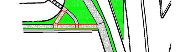
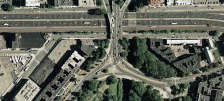
Charlesgate. World Series Path
|
|
|
- Maria Cummings
- 5 years ago
- Views:
Transcription
1 Tonight s 8 Greenway Designs Commonwealth Ave. Route 9 Crossing Charlesgate Dartmouth St. World Series Path Summer St / L St Arborway
2 2008 Charlesgate Connection Northeastern University s Civil Engineering Transportation Design Capstone Bicycling Around the Back Bay Matt Volovski Vl Kelly Chronley Josh Barnett Tony Coward The BaBBs
3 Creating a Connection Between the Charles River Esplanade And The Back Bay Fens
4 The Charles River Esplanade
5 The Back Bay Fens
6 Connect: The Charles River Esplanade
7 With: The Back Bay Fens
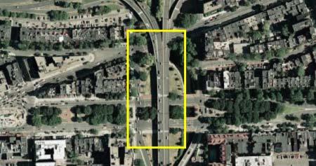
8 Through: The Charlesgate Connection

9 Introduction Utilized by a Wide Array of Users Commuters Recreationalists Harvard University with Harvard Medical Boston University with Boston University Medical MIT University with Longwood Medical Area and Jamaica Plain Massachusetts General Hospital with Longwood Medical Area and Jamaica Plain Downtown to Fenway/Jamaica Plain Connects the beautiful Charles River and Fens Parks Provides access to Olmsted s Park Discovers the Lost Park
10 Previous Proposals Emerald Necklace Master Plan (1989) Muddy River Delta Proposal (1996) Charlesgate Interchange Park Charrette (1998) The Emerald Necklace Greenway Plan (2001) The MDC Charlesgate Connection Plan (2002) The Boston Bicycle Summit (2007)


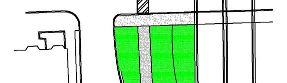
11 General Specifications Accommodates: Pedestrian Cyclists Handicapped 12 foot width Buffered from traffic Our Design General Overview


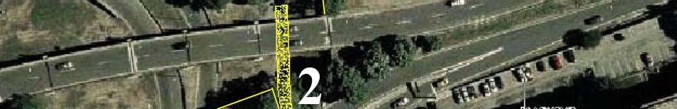
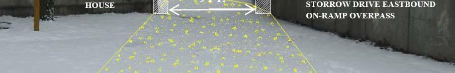
12 The Objective: Bowker Overpass To get between the Bowker/Boylston intersection and Commonwealth Ave. Currently the sidewalks on the Bowker Overpass are inadequate, only 6 wide and un-buffered from traffic. The Obstacles: The Massachusetts Turnpike The railroad tracks The Bowker Overpass The Need: Additional width on the overpass The structure can not support a cantilevered pedestrian bridge A free-standing pedestrian bridge over the Mass. Pike and railway would be Long (>200 ) and costly

13 Northbound Lanes Currently there are 3 southbound lanes and 3 northbound lanes 3 southbound lanes are critical to the functionality of the intersection 3 northbound lanes only serve the function of 2 lanes: Only 2 lanes of traffic ever enter the northbound ot lanes Creates additional movements and conflicts for drivers Elimination of 1 NB lane would increase driving i safety while providing space for a pathway.


14 Off-ramp vs. On-ramp Which Side of the Overpass is Best Suited for the Path?


15 Northbound Off-ramp Feasibility Single narrow sidewalk Not ADA compliant Would be very difficult to gain compliance 2 lanes Both are necessary for queue storage Ramp structure can not support cantilever


16 Southbound Onramp Feasibility Single narrow sidewalk Not ADA compliant Currently there is a ramp that can be upgraded for compliancy 2 lanes Both are not necessary Two lanes merge down to one before entering the overpass Ramp structure can be altered

17 Moving The Median


18 Moving The Median Existing Conditions This is an image taken from the Bowker/Boylston Intersection looking at the southbound lanes of the Bowker Overpass. Proposed Conditions This is a rendering of what the southbound lanes of the Bowker Overpass will look like.


")
 Not")
 The")


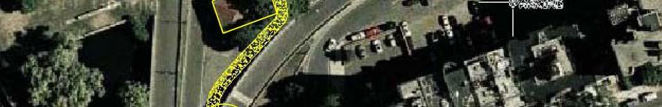
19 Southbound Onramp Alternatives ti Considered d (A) Requires crossing Charlesgate West traffic twice (A) (B) Not enough width (C) Not enough clearance (D1, 2, 3) The final three alternatives were paths that crossed over the on-ramp at different locations.


20 The Selected Design The Onramp Crossing Features: Signaled crossing 125 from intersection providing room for 10 cars in a queue Separate ADA ramp to Charlesgate West and Newbury St.
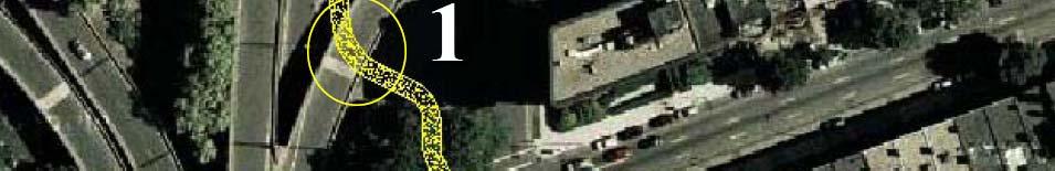
21 New Path Down from the Bowker Onramp to Commonwealth Ave. EB

 Motorists will be slowing to round the")
22 ADA Compliance Connects Overpass to the corner of Charlesgate West and Newbury Street. Ideal Crossing Location Because: Clear sightline down Charlesgate West Short crossing distance (25 ) Motorists will be slowing to round the corner ADA Features: 1/12 slope Landings g every 30 linear feet


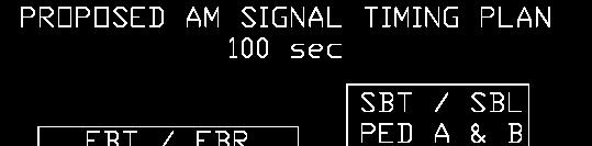
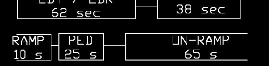
23 Bowker Overpass / Boylston Street Intersection ti Timings i Objective: Improving pedestrian service through intersection While maintaining or improving vehicular service
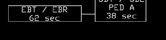
24 Signal Timing Plan Modifications: Minimizing Delay for Pedestrians and Vehicles Pedestrians delay shortens from 69 sec to 38 sec and from 41 sec to 38 sec Vehicular delay maintained or improved

25 Signal Timing Coordination


26 Olmsted s s Park Four Patches Connected Concurrent Pedestrian Phases across Charlesgate East and West.


27 Olmsted s Park Beacon Street Multi-use use path adjacent to the south side of Beacon. Currently oversized lanes Reduce lane width to standard 12 Expand south curb line Creates a constant sightline down Beacon Allows island to be enlarged


28 Olmsted s Park Beacon Street Expand South Curb line Creates a constant sightline down Beacon Allows island to be enlarged

29 Two Obstructions
30 Go to Right of Pier: Two Obstructions (Overpass Clearance) Left side of pier does not have required width Left side of pier in not buffered from traffic


31 Two Obstructions (Overpass Clearance) Alternative Right Side of Pier Current overhead clearance for right side of pier
 Alternative B: Right")

32 Two Obstructions (Overpass Clearance) Alternative B: Right Side of Pier Overhead Clearance for Right Side of Pier After Re-grading


33 Excavation Under Overpass Drainage solution Two Obstructions (Overpass Clearance)


34 Two Obstructions (Gate House)


35 The Lost Park View along the Charles River downstream View from the upper level l of the park -Reclaiming 2.5 acres of parkland near the Charles River -Creating a destination rather than just a connection
36 Establishing Destination

37 Proposed Path Layout
38 Storrow Drive Westbound Crossings (4 Bridge/Ramp Alternatives) All bridges were designed meeting the following requirement: A clearance of 12 from Storrow Drive to the bottom of the bridge deck A 1 thick bridge deck A single span crossing Storrow Drive supported on both sides with piers An overall width of 12 The ramp is compliant with ADA requirements 1/12 slope Landings provided every 2.5 of elevation change


39 Alternatives A & B Alternative A: Bridge crossing to the west and the resulting 193 ramp down towards the east Alternative B Bridge crossing to the east and the resulting 150 ramp down towards the west


40 Alternatives C & D Alternative C The design calls for a piers to be placed in the Charles River. The major benefit is the relatively low visual impact. Alternative D The grand design. It calls for a cablestayed ramp extending over the river.
 Typical Elevation 3-D")
41 Alternative D (cont.) Typical Elevation 3-D Rendering
42 Alternatives Comparison Table Alternative Extra Travel Distance Horizontal Distance (Compaired to best Alternative) Impact over River Upstream Downstream A 193' 0' 464' 407' B 150' 0' 342' 0' C 52' 62' 65' 240' D 114' 32' 0' 291'
43 Cost Estimate (Excluding Footbridge)


44 Questions? Acknowledgements: This report could not have been possible without the support of our Professor Peter Furth and the coordination of our design team. We would like to first thank VHB and the Boston Water and Sewer Commission for providing the CAD files for the existing conditions of the Charlesgate connection. We also would like to recognize Herb Nolan of the Solomon Fund for showing interest to advance this project further once we graduate. A few others we would like to thank: Nicole Freedman, Boston s Bicycle Planner, Noah Bierman, Boston Globe, John Kennedy, VHB, John Ciccarelli, Bicycle Solutions, and Northeastern University for providing the survey equipment, as well as the software to finish this project.
Charlesgate Connection
 2008 Charlesgate Connection Bicycling Around the Back Bay The Babbs Matthew Volovski Kelly Chronley Joshua Barnett Anthony Coward TABLE OF CONTENTS Table of Contents... 2 List of Tables and Figures...
Landmark Center Rotary Path and Roadway Redesign Team Members:
 Path and Roadway Redesign Executive Summary Team Members: PM: Will Miller Jeff Haelle Nick Gaboury John Tamburrini Jon Simmons Table of Contents Page 1 Locus Map... 2 Introduction... 3 Current Problems
Bridging the Gaps in the Emerald Necklace:
 Bridging the Gaps in the Emerald Necklace: Route 9 to Brookline Avenue 1 G.R.8 Engineers Inc. Tony Cennamo Allison Goulet Zach Shapiro Ryan St.Martin BRIDGING THE GAPS IN THE EMERALD NECKLACE: Route 9
July 13, Commissioner Richard Sullivan Department of Conservation and Recreation 251 Causeway Street Boston, MA RE: EOEA ENF 13777
 July 13, 2007 Commissioner Richard Sullivan Department of Conservation and Recreation 251 Causeway Street Boston, MA 02110-1301 RE: EOEA ENF 13777 Dear Commissioner Sullivan: WalkBoston has been a steady
Draft North Industrial Area-Wide Traffic Plan
 Summary of North Industrial and Hudson Bay Industrial Recommended Improvements Table 1. Summary of s Item Location 1 2 3 4 5 6 7 8 9 10 11 12 Millar Ave north of 51st St Super 8 Motel back lane 400 Block
Landmark Center Rotary Path and Roadway Redesign
 Landmark Center Rotary Path and Roadway Redesign "We want a ground to which people may easily go when the day's work is done, and where they may stroll for an hour, seeing hearing and feeling nothing of
Blair/Williamson Intersection Expressed Needs
 Blair/Williamson Intersection Expressed Needs NORTH Blair Street is a barrier for pedestrians and bicycles Relocate Capitol City Trail crossing from Blair Street and John Nolen Drive intersection to Williamson
Agassiz Road Back Bay Fens Boston, Massachusetts
 Conceptual Design Report Agassiz Road Back Bay Fens Boston, Massachusetts March 2012 Massachusetts Department of Conservation and Recreation Bureau of Planning and Resource Protection In partnership with
Appendix K Pedestrian Bridge Feasibility Report. Rehabilitation and Restoration of the Longfellow Bridge
 Appendix K Pedestrian Bridge Feasibility Report Rehabilitation and Restoration of the Longfellow Bridge Pedestrian Bridge Feasibility Report Longfellow Bridge Rehabilitation and Restoration Boston, Massachusetts
Charles River Pathways
 Charles River Pathways Dr. Paul Dudley White Bike Path Museum of Science to Watertown Square Analysis of the South Shore with conceptual design Proposal Charles River Conservancy August 2006 Prepared by
Welcome. 53 Avenue Overpass over Whitemud Drive Rehabilitation. Public Information Session. Wednesday, March 9, :30-8:00 p.m.
 BRIDGE REHABILITATION Welcome 53 Avenue Overpass over Whitemud Drive Rehabilitation Public Information Session Wednesday, March 9, 2016 4:30-8:00 p.m. Tonight you can: Learn about the 53 Avenue Overpass
01. VICINITY OF GREENBRAE POC: EXISTING CONDITIONS
 01. VICINITY OF GREENBRAE POC: EXISTING CONDITIONS Existing Bus Stop Existing US101 On-ramp Existing POC Old Redwood Highway Rich Street City ROW Environmental Study Limit Industrial Way NO DESIGNATED
Washington St. Corridor Study
 FIGURE 7.17 Bridge Alternatives - Cross Sections 86 Discarded Alternative: Short-Term Bridge Repair Short-term repairs and west bridge span replacement were considered during analysis. Short-term repairs
California Department of Transportation, District 4. Sloat Boulevard Project Skyline Blvd. to 19 th Ave. Community Update January 13, 2016
 California Department of Transportation, District 4 Sloat Boulevard Project Skyline Blvd. to 19 th Ave. Community Update January 13, 2016 Agenda Welcome and introductions Project overview, history and
Clybourn Ave. Protected Bike Lane Study Halsted St. to Division St.
 Clybourn Ave. Protected Bike Lane Study Halsted St. to Division St. Nathan Roseberry, Senior Engineer Pam Broviak, Project Manager July 24, 2014 Agenda Project Goals Existing Roadway Conditions Traffic
Appendix T CCMP TRAIL TRAFFIC & TRANSPORTATION DESIGN STANDARD
 Appendix T CCMP 3.3.4 TRAIL TRAFFIC & TRANSPORTATION DESIGN STANDARD 3.3.4 Trail Traffic and Transportation Design Multi-use trails have certain design standards, which vary depending on the agency that
Bicycle + Pedestrian Connectivity Gap Analysis
 Accelerated Bridge Program Bicycle + Pedestrian Connectivity Gap Analysis Tuesday, October 11 Shriners Hospital, Boston 6:30-8:00 PM Thursday, October 13 Community Rowing, Brighton 6:30-8:00 PM Tuesday,
Scarlett Road Bridge & Road Improvements Lambton Park Community School - Gymnasium Tuesday November 28 th, 2017
 Scarlett Road Bridge & Road Improvements Lambton Park Community School - Gymnasium Tuesday November 28 th, 2017 PROJECT LOCATION 2 SCARLETT ROAD BRIDGE Constructed in 1912, the bridge carries 4 active
2014/2015 BIKE ROUTE PLAN 83 AVENUE PROTECTED BIKE LANE
 About the Project The City of Edmonton is planning a major bike route on the southside of Edmonton. The Strathcona Bike Route will connect the communities of Strathcona, Garneau and the University area,
Saskatchewan Drive Roadway Rehabilitation and Shared-Use Path Widening
 Saskatchewan Drive Roadway Rehabilitation and Shared-Use Path Widening We are here today to present the draft plan for the Saskatchewan Drive Roadway Rehabilitation and Shared-Use Path Widening project
ADA PRESENTATION (CURB RAMPS)
") ADA PRESENTATION (CURB RAMPS) ACECNJ/NJDOT/FHWA DESIGN SUMMIT Warren Howard New Jersey Department of Transportation May 21, 2013 ADA Curb Ramps NJDOT wants curb ramps to be designed & constructed properly
ADA PRESENTATION (CURB RAMPS) ACECNJ/NJDOT/FHWA DESIGN SUMMIT Warren Howard New Jersey Department of Transportation May 21, 2013 ADA Curb Ramps NJDOT wants curb ramps to be designed & constructed properly
72 Avenue Four Laning (BNSF Overpass to 120 Street) WELCOME. Public Information Meeting
 WELCOME. Public Information Meeting") 72 Avenue Four Laning (BNSF Overpass to 120 Street) WELCOME Public Information Meeting Project Goals About the Project The goal of this project is to address congestion along 72 Avenue and adjacent streets
72 Avenue Four Laning (BNSF Overpass to 120 Street) WELCOME Public Information Meeting Project Goals About the Project The goal of this project is to address congestion along 72 Avenue and adjacent streets
Bay to Bay Boulevard Complete Streets Project
 Bay to Bay Boulevard Complete Streets Project Dale Mabry Highway to Bayshore Boulevard February 08, 2018 Photo Source: Tampa Bay Times Alessandra Da Pra Meeting Format Introduction Resurfacing Information
Approximately 360 trail users cross during a typical summer weekday and 420 cross during a typical summer
 5. PARKR ROAD AT MISSISSIPPI AVN CROSSIN xisting Conditions The High ine Canal trail crosses Parker Road near the Mississippi Avenue intersection (crossing location #3 on Figure 1). South of Parker, the
HIGHBURY AVENUE/HAMILTON ROAD INTERSECTION IMPROVEMENTS PUBLIC INFORMATION CENTRE 1 MAY 14, 2015
 HIGHBURY AVENUE/HAMILTON ROAD INTERSECTION IMPROVEMENTS Municipal Class Environmental Assessment PUBLIC INFORMATION CENTRE 1 MAY 14, 2015 ACCESSIBILITY Under the Accessibility Standards 2015 for Customer
Old Colony Bikeway. Erin Pacileo Joe Conroy Pat Ruby Ryan Hipp. Civil & Environmental Engineering. South Bay Center. Moakley Park.
 Old Colony Bikeway South Bay Center Dorcheste er Ave. Old Colo ony Ave. Moakley Park UMass Boston Erin Pacileo Joe Conroy Pat Ruby Ryan Hipp Outline Project Overview Objectives & Goals Proposed Corridor
South End Transportation Study. Public Meeting. January 31, 2019 Welcome. Public Meeting. January 10, 2018 WELCOME
 Public Meeting January 31, 2019 Welcome Public Meeting January 10, 2018 WELCOME What You Will Hear Tonight All ideas presented are options currently under consideration Study Team found no single solution
WELCOME Public Information Centre
 WELCOME Public Information Centre Fernforest Drive Brampton Soccer Centre Community Room #2 Tuesday January 19, 2016 6:30 p.m.to 9:00 p.m. Please sign in Neighbourhood Traffic Calming Guide Background
Central Avenue Bikeway Traffic and Safety Impact Assessment
 FEBRUARY 2018 Lead Agency: San Diego Association of Governments (SANDAG) 401 B Street, Suite 800 San Diego, CA 92101 Contact: Chris Carterette, AICP, Project Manager 619.699.7319 chris.carterette@sandag.org
City of Davis East Covell Corridor Plan
 Community Open House #2 January 22, 2014 6:00 8:00 p.m. Veterans Memorial Center, Club Room City of Davis Introduction The (ECCP) is a taking a comprehensive look at the existing transportation systems
City of Albert Lea Policy and Procedure Manual 4.10 ALBERT LEA CROSSWALK POLICY
 4.10 ALBERT LEA CROSSWALK POLICY PURPOSE: Pedestrian crosswalks are an integral part of our transportation infrastructure. To be effective and promote safety, marked crosswalks must be installed after
MEMORANDUM. Charlotte Fleetwood, Transportation Planner
 MEMORANDUM Date: Updated August 22, 2017 To: Organization: Charlotte Fleetwood, Transportation Planner Boston Transportation Department From: Jason DeGray, P.E., PTOE, Regional Director of Engineering
Richmond-Adelaide Cycle Tracks
 Public Drop-In Event Richmond-Adelaide Cycle Tracks June 25, 2018 12:00 p.m. 3:00 p.m. 4:30 p.m. 7:30 p.m. Metro Hall, Rotunda 55 John Street 1 Purpose of Event In Scope Communicate an update about the
Appendix A: Crosswalk Policy
 Appendix A: Crosswalk Policy Appendix A: Crosswalk Policy Introduction This citywide Crosswalk Policy is aimed at improving pedestrian safety and enhancing pedestrian mobility by providing a framework
General Design Factors
 Chapter 3: 3-1.0 Introduction General Design Factors Mn/DOT s goals include encouraging and accommodating safe bicycling. From a design perspective, these goals are achieved by first having an understanding
Route 79/Davol Street Corridor Study
 Route 79/Davol Street Corridor Study Fall River, MA Public Information Meeting #2 November 21, 2013 Fall River Heritage State Park Fall River, MA Agenda Welcome and Introductions Overview of Study Process
City of Madison, East Johnson Street North Baldwin Street to First Street Local Street Dane County
 City of Madison, East Johnson Street North Baldwin Street to First Street Local Street Dane County Public Involvement Meeting Thursday, April 28, 2016 6 to 8 P.M. Lapham Elementary School 1045 E. Dayton
Alewife Bicycle and Pedestrian Access Study
 Alewife Bicycle and Pedestrian Access Study July 2009 Final Report 1. Study Purpose The Alewife Access Study has been commissioned to provide recommendations for improving pedestrian and bicycle access
Los Altos Hills Town Council - June 18, 2015 Palo Alto City Council June 22, AGENDA ITEM #2.B Presentation
 Los Altos Hills Town Council - June 18, 2015 Palo Alto City Council June 22, 2015 AGENDA ITEM #2.B Presentation Previous Presentations Los Altos Hills Town Council in May 2014 and February 2015 Palo Alto
Guidance. ATTACHMENT F: Draft Additional Pages for Bicycle Facility Design Toolkit Separated Bike Lanes: Two-Way to One-Way Transitions
 ATTACHMENT F: Draft Additional Pages for Bicycle Facility Design Toolkit Separated Bike Lanes: Two-Way to One-Way Transitions This treatment provides a transition from two-way separated bike lanes to one-way
Thank you for attending
 Improving mobility safety comfort WELCOME Thank you for attending The purpose of this meeting is to: Learn about the project Prioritize potential walking and biking improvements on Snelling Ave Gather
Agenda. Overview PRINCE GEORGE S PLAZA METRO AREA PEDESTRIAN PLAN
 PRINCE GEORGE S PLAZA METRO AREA PEDESTRIAN PLAN May 28, 2008 Agenda Welcome and introductions Project overview and issue identification Planning context and strengths Design challenges and initial recommendations
What Is a Complete Street?
 Session 5 Charleen Zimmer, AICP, Zan Associates May 5-7, 2010 What Is a Complete Street? May 2010 5-1 Not a Complete Street More of a Complete Street May 2010 5-2 Benefits of Complete Streets Safety for
Corydon-Osborne Neighbourhood Plan Recommendations
 Corydon-Osborne Neighbourhood Plan Recommendations November 12, 2013 Plan Boundaries The current boundaries of Stafford Street to the west and Donald Street to the east ignore two key cycling routes; Harrow
Welcome to the Quebec Alternatives Analysis Public Meeting
 Welcome to the Public Meeting Please sign in. Public Comment Please fill out a comment card and tell us what you think. Check back or comment any time at: www.quebecalternatives.com Project Area Technical
CITY OF ALBANY TRAFFIC AND SAFETY COMMISSION
 CITY OF ALBANY TRAFFIC AND SAFETY COMMISSION City Hall - Council Chambers 1000 San Pablo Avenue, Albany, CA 94706 Wednesday, November 30, 2016, 7:00 PM 1. CALL TO ORDER The meeting was called to order
Off-road Trails. Guidance
 Off-road Trails Off-road trails are shared use paths located on an independent alignment that provide two-way travel for people walking, bicycling, and other non-motorized users. Trails specifically along
Citywide Sidewalk and Crosswalk Programs
 Citywide Sidewalk and Crosswalk Programs Council Meeting October 20, 2015 Presented by Rita Hu and Jamal Mahmoud Program Goals Implement the City s comprehensive plan. Provide pedestrian with safe walking
Cycle Track Design Best Practices Cycle Track Sections
 Design Best Practices Sections It is along street segments where the separation and protection methods of cycle tracks offer more comfort than conventional bicycle lanes, and are more attractive to a wide
DUNBOW ROAD FUNCTIONAL PLANNING
 DUNBOW ROAD FUNCTIONAL PLANNING Final Report August 3, 216 #31, 316 5th Avenue NE Calgary, AB T2A 6K4 Phone: 43.273.91 Fax: 43.273.344 wattconsultinggroup.com Dunbow Road Functional Planning Final Report
Date: April 4, Project #: Re: A Street/Binford Street Traffic/Intersection Assessment
 To: Peter Cavanaugh General Electric From: David Bohn, PE Ryan White, PE Date: April 4, 217 Project #: 13421. Re: / Traffic/Intersection Assessment Consistent with the Cooperation Agreement between the
Toronto and East York Community Council. Director, Transportation Services, Toronto and East York District
 No Turn on Red Regulations STAFF REPORT ACTION REQUIRED Date: June 1, 2010 To: From: Toronto and East York Community Council Director, Transportation Services, Toronto and East York District Wards: Trinity
CURBSIDE ACTIVITY DESIGN
 5 CURBSIDE ACTIVITY DESIGN This chapter provides design guidance for separated bike lanes adjacent to curbside activities including parking, loading and bus stops. Typical configurations are presented
FY 2006 TRANSPORTATION CAPITAL PROGRAM
 Eden Lane Bridge over Whippany River NS9908 The existing structure was built in 1972 as a temporary single-span structure. The bridge consists of simply supported steel acrow panel trusses and is supported
Overview. Illinois Bike Summit IDOT Complete Streets Policy Presentation. What is a Complete Street? And why build them? And why build them?
 Overview Illinois Bike Summit IDOT Complete Streets Policy Presentation Aren Kriks, P.E. District One Bicycle Coordinator and Bureau of Programming Project Engineer History of Complete Streets IDOT Policy
Table 1.0 Grade Crossing Enhancements PVL San Jacinto Branch Line
 Grade Crossing Enhancements CPUC 1 2 3 4 5 Citrus Avenue, Riverside County Palmyrita Ave., Columbia Avenue, Marlborough Ave., Spruce St., MP 0.57 002X-0.6 027301Y MP 1.00 002X-1.0 027302F MP 1.24 002X-1.3
PEDESTRIAN ACCOMMODATIONS DPS 201 AT INTERCHANGES
 PEDESTRIAN ACCOMMODATIONS DPS 201 AT INTERCHANGES UNDERSTANDING THE ISSUES Intersections of freeway ramp terminals at crossroads are the most critical components of an interchange Challenge: balance mobility
Pattullo Bridge Replacement Project Community Connections Phase 2 Consultation. Appendix 3: Open House Display Boards
 Replacement Project Community Connections Phase 2 Consultation Appendix 3: Open House Display Boards November 2016 Welcome! Welcome to the Replacement Project Public Open House We Want to Hear from You
CHAPTER 16 PEDESTRIAN FACILITIES DESIGN AND TECHNICAL CRITERIA TABLE OF CONTENTS
 CHAPTER 16 PEDESTRIAN FACILITIES DESIGN AND TECHNICAL CRITERIA TABLE OF CONTENTS Section Title Page 16.1 General... 16-1 16.1.1 AASHTO Reference... 16-1 16.1.2 ADA Requirements... 16-1 16.2 Sidewalks...
BETHEL ROAD AND SEDGWICK ROAD CORRIDOR STUDY
 DRAFT PLAN City Council Meeting August 14, 2017 STUDY AREA Sedgwick Corridor State Route 160, principal arterial with Class 3 access management designation, commuter and freight route, connection to SR
WELCOME. Stakeholder Involvement Group Meeting #2 Round Lake Public Works October 24, 2018
 WELCOME Stakeholder Involvement Group Meeting #2 Round Lake Public Works October 24, 2018 MEETING AGENDA 1. Welcome and Introductions 2. Study Progress Update 3. Problem Statement 4. Technical Analysis
Bicycle Facilities Planning
 Bicycle Facilities Planning Overview Types of Cyclists Purpose for Riding Types of Facilities Bike Lanes Bicycle Boulevards Cycle Tracks Intersections Signals Signing and Marking Discussion Types of Bicyclists
TRANSPORTATION IMPACT STUDY PROPOSED RIVERFRONT 47 MIXED USE DEVELOPMENT
 November 2016 TRANSPORTATION IMPACT STUDY PROPOSED RIVERFRONT 47 MIXED USE DEVELOPMENT & Aspinwall Borough, Sharpsburg Borough & O Hara Township, Allegheny County, Pennsylvania Prepared for: Riverfront
2014/2015 BIKE ROUTE PLAN 83 AVENUE PROTECTED BIKE LANE
 About the Project 2014/2015 BIKE ROUTE PLAN The City of Edmonton is planning a major bike route on the south side of Edmonton. This bike route is one part of a plan to provide citizens with transportation
San Pablo High Treatment applied incrementally at each N + ++
 Transit Improvements T1 Further study options for creation or designation of segregated transit lanes along San Pablo, including options for restrictions during a limited number of peak travel hours and
DRAFT Sellwood Bridge Existing Roadway Deficiencies
 Technical Memorandum DRAFT Sellwood Bridge Existing Roadway Deficiencies Executive Summary Purpose Roadway design standards are developed to support safety and mobility goals. Roadway deficiencies have
Delay Estimation and Signal Timing Design Techniques for Multi-Stage Pedestrian Crossings and Two-Stage Bicycle Left Turns
 Delay Estimation and Signal Timing Design Techniques for Multi-Stage Pedestrian Crossings and Two-Stage Bicycle Left Turns Peter G Furth (corresponding author) Northeastern University, room 400 SN 360
City of Moorhead Committee of the Whole Meeting
 City of Moorhead Committee of the Whole Meeting Corridor Study Limits Center Avenue (Red River to 8th Street) TH 10 (Red River to TH 336) TH 75 (20th Ave S to Main Avenue) 2 Study Need: Project Overview
Harrah s Station Square Casino
 Transportation Analysis Harrah s Station Square Casino Pittsburgh, Pennsylvania Submitted To: City of Pittsburgh and Pennsylvania Gaming Control Board Prepared By: DKS Associates GAI Consultants December
Route 245 over Broad Run. The recently replaced bridge links The Plains and other communities in northern Fauquier to Interstate 66.
 28 VIRGINIA DEPARTMENT OF TRANSPORTATION \\ CULPEPER DISTRICT Route 245 over Broad Run. The recently replaced bridge links The Plains and other communities in northern Fauquier to Interstate 66. PROJECT
Watertown Complete Streets Prioritization Plan. Public Meeting #1 December 14, 2017
 Watertown Complete Streets Prioritization Plan Public Meeting #1 December 14, 2017 Goals for Public Meeting Overview of MassDOT Complete Streets Funding Program Educate the community on Complete Streets
Ottawa Beach Road Study
 Ottawa Beach Road Study Prepared For: Park Township September 30, 2014 Project No. G140303 OTTAWA BEACH ROAD STUDY PREPARED FOR: PARK TOWNSHIP SEPTEMBER 30, 2014 PROJECT NO. G140303 TABLE OF CONTENTS 1.0
May 4, Dear Mr. Thomas and Mr. Snyder,
 Daniel Thomas, Principal Planner Christopher Snyder, County Engineer DuPage County Division of Transportation 421 N County Farm Road Wheaton, IL 60187 May 4, 2016 Dear Mr. Thomas and Mr. Snyder, On behalf
Balancing Operation & Safety for Motorized and Non-Motorized Traffic
 Balancing Operation & Safety for Motorized and Non-Motorized Traffic Brian Willham, PE, PTOE Iowa Director - MOVITE June 30, 2014 Learning Objectives: When & Why should we measure the performance of complete
Public Information Meeting. Orange Camp Road. Dr. Martin Luther King Jr. Beltway to I-4. Presented by: Volusia County August 2, 2018
 Public Information Meeting Orange Camp Road Dr. Martin Luther King Jr. Beltway to I-4 Presented by: Volusia County August 2, 2018 1 Project Goals To improve the operations and safety for Orange Camp Road
Transportation Planning Division
 Transportation Planning Division Presentation Outline Study Tasks Recap of Previous Meetings Data Collected Focus Areas within Study Limits Design Principles Tool Box Recommended Concepts Schedule Moving
Public Information Centre
 WELCOME Public Information Centre Father Tobin Road Lougheed Middle School - Library Wednesday November 7, 2012 7:00 p.m.to 9:00 p.m. Please sign in Neighbourhood Traffic Calming Guide Background The City
Low Level Road Improvements Traffic Analysis. Report
 Low Level Road Improvements Traffic Analysis Report June, 22 Table of Contents. INTRODUCTION.... LOW LEVEL ROAD PROJECT....2 STUDY AREA....2. West-End Corridor Improvements... 2.2.2 East-End Corridor Improvements...
Coquitlam Cross-town Bike Route Improving Bicycle Facilities in a Mature Suburban Environment
 Coquitlam Cross-town Bike Route Improving Bicycle Facilities in a Mature Suburban Environment Sarah Rocchi, Vice-President, Projects, Opus International Consultants (Main Presenter) Catherine Mohoruk,
Improvements Infrastructure Gap Assessment and Improvements Street Striping
 Infrastructure Project Proposal The federal-aid Safe Routes to School program funds infrastructure/engineering projects that fall into two categories: Design (available only to School Development Authority
PEDESTRIAN CROSSING TREATMENTS
 PEDESTRIAN CROSSING TREATMENTS BEST PRACTICES Presented by: Doug Enderson, P.E., PTOE Cody Salo, P.E. 1 PRESENTER INTRODUCTIONS Doug Enderson, P.E., PTOE Ped Crossing Experience: ADA Design-Build ADA Inventory
Terwillegar Drive Expressway Draft Concept Plan
 Terwillegar Drive Expressway Draft Concept Plan Anthony Henday Drive to Whitemud Drive November 28 5:00-8:00 p.m. December 1 10:00 a.m. - 3:00 p.m. Let s Talk Today you can: Learn about the new direction
Bicycle and Pedestrian Advisory Committee (BPAC) November 21, 2013
 November 21, 2013") Bicycle and Pedestrian Advisory Committee (BPAC) November 21, 2013 OVERALL LAND USE CONCEPT Overall Broadway Valdez District: 95.5 acres (35.1 acres right-of ways + 60.4 acres developable land) Plan Subareas:
Bicycle and Pedestrian Advisory Committee (BPAC) November 21, 2013 OVERALL LAND USE CONCEPT Overall Broadway Valdez District: 95.5 acres (35.1 acres right-of ways + 60.4 acres developable land) Plan Subareas:
2016 I-30 CROSSING ARKANSAS BOULEVARD KEY IDEAS OF PLAN B:
 KEY IDEAS OF PLAN B: Transportation shall support all parts of the cities and improve the quality of life downtown. There is no need to shorten commuting time at rush hour by a few minutes at the risk
Broad Street Bicycle Boulevard Design Guidelines
 Broad Street Bicycle Boulevard Design Guidelines Building from the strategies introduced in the 2013 Bicycle Transportation Plan and community input received thus far, City Transportation Staff have identified
Municipal Class EA To Address Traffic Congestion On The Ontario Street Corridor (Grand Bend) Public Information Meeting June 4, 2018
 Public Information Meeting June 4, 2018") Municipal Class EA To Address Traffic Congestion On The Ontario Street Corridor (Grand Bend) Public Information Meeting June 4, 2018 Background Agenda Traffic Study Update Class EA Alternatives Bridge
Municipal Class EA To Address Traffic Congestion On The Ontario Street Corridor (Grand Bend) Public Information Meeting June 4, 2018 Background Agenda Traffic Study Update Class EA Alternatives Bridge
Tonight is for you. Learn everything you can. Share all your ideas.
 Strathcona Neighbourhood Renewal Draft Concept Design Tonight is for you. Learn everything you can. Share all your ideas. What is Neighbourhood Renewal? Creating a design with you for your neighbourhood.
State Road 54/56 Tampa Bay s Northern Loop. The Managed Lane Solution Linking I-75 to the Suncoast Parkway
 State Road 54/56 Tampa Bay s Northern Loop The Managed Lane Solution Linking I-75 to the Suncoast Parkway SUNCOAST PARKWAY Both I 75 and the Suncoast Parkway are planning, or in the process of constructing,
Trans-Canada Highway 1 RW Bruhn Bridge Replacement
 Trans-Canada Highway 1 RW Bruhn Bridge Replacement May 2016 RW Bruhn Bridge Project Objectives Improve safety, traffic flow and movement of goods Improve safety for pedestrians and cyclists Replace the
CAPITOL DRIVE & FOND DU LAC AVENUE INTERSECTION ANALYSIS. Urban Planning 772 SARAH BREGANT, RYAN PETERSON, & MATT WERDERITCH
 CAPITOL DRIVE & FOND DU LAC AVENUE INTERSECTION ANALYSIS Urban Planning 772 SARAH BREGANT, RYAN PETERSON, & MATT WERDERITCH OVERVIEW N 51 ST BOULEVARD N 51 ST BOULEVARD 12,100 44,700 W CAPITOL DRIVE 52,600
Station 1: Street & Sidewalk Upgrades
 Station 1: Street & Sidewalk Upgrades Existing no left turn; Potential left turn arrow, see Circulation Study boards for more information Thru-lane guidance Improved lead-in green bike lane 17TH ST CASTRO
section 4 Existing Conditions, Issues, and Options
 section 4 Existing Conditions, Issues, and Options 4.0 Existing Conditions, Issues, and Options This section analyzes each segment of the corridor on a street to street basis. Each segment is discussed
Purpose: Financial Implications and Impact Statement: It is estimated that the cost to implement:
 Various Modifications Lower Jarvis Street and Lake Shore Boulevard East; Lower Jarvis Street, east side, between Lake Shore Boulevard East and The Esplanade - 45-77 Lower Jarvis Street; and Lower Jarvis
CITY OF OTTAWA ROADWAY MODIFICATION APPROVAL UNDER DELEGATED AUTHORITY
 RMA-2015-ATM-038 CITY OF OTTAWA ROADWAY MODIFICATION APPROVAL UNDER DELEGATED AUTHORITY DATE: April 22, 2015 SUBJECT Approval of Roadway Modifications Recommended through an Area Traffic Management Study
I-90 ALLSTON INTERCHANGE A MULTIMODAL TRANSPORTATION PROJECT MEPA CONSULTATION MEETING NOVEMBER 20, 2014 BRIGHTON HIGH SCHOOL
 I-90 ALLSTON INTERCHANGE A MULTIMODAL TRANSPORTATION PROJECT MEPA CONSULTATION MEETING NOVEMBER 20, 2014 BRIGHTON HIGH SCHOOL Today s Agenda 1. 2. 3. 4. 5. Overview of the MEPA Process Project Overview
Agenda Item # Page # RECOMMENDATION
 TO: FROM: SUBJECT: CHAIR AND MEMBERS CIVIC WORKS COMMITTEE MEETING ON FEBRUARY 2, 2016 JOHN BRAAM, P. ENG. MANAGING DIRECTOR, ENVIRONMENTAL & ENGINEERING SERVICES AND CITY ENGINEER FIELD MARSHAL WOLSELEY
APPENDIX A: Complete Streets Checklist DRAFT NOVEMBER 2016
 APPENDIX A: Complete Streets Checklist DRAFT NOVEMBER 2016 Complete Streets Checklist MetroPlan Orlando s Complete Streets Checklist is an internal planning tool for staff to further implementation of
6.4 RECOMMENDED IMPROVEMENTS
 6.4 RECOMMENDED IMPROVEMENTS 6.4.1 Williston Road Recommendations While all alternatives would be an improvement over existing conditions, Alternative 3B is recommended over the others because it provides
Multi-Modal Traffic Analysis. Parisi and Associates
 Mill Valley to Corte Madera Bicycle and Pedestrian Corridor Study Appendix D: Multi-Modal Traffic Analysis Prepared by Parisi and Associates August 2009 Appendix D - Multi-Modal Traffic Analysis Table
5. RUNNINGWAY GUIDELINES
 5. RUNNINGWAY GUIDELINES These guidelines should be considered collectively when making runningway decisions. A runningway is the linear component of the transit system that forms the right-of-way reserved