Table of Contents... i. 1. Introduction Proposed Amendment C162 (Mt Atkinson and Tarneit Plains PSP) Overview...
|
|
|
- Roger Lucas
- 6 years ago
- Views:
Transcription
1
2
3 TABLE OF CONTENTS Table of Contents... i 1. Introduction Proposed Amendment C162 (Mt Atkinson and Tarneit Plains PSP) Overview Design Principles & Relevant Guideline Documents Location The Transport Network Melton City Council Issues Intersections IT01 & IT02 Design adequacy Road cross sections for primary and secondary arterials Intersection IT05 Identification of a preferable location My Opinion Intersections IT01 & IT02 Design adequacy Road cross sections for primary and secondary arterials Intersection IT05 Identification of a preferable location Declaration Appendix A Matters Raised by PPV Guide to Expert Evidence Appendix B Curriculum Vitae i
4 ii
5 1. INTRODUCTION My name is Stephen Pelosi and I am a Director at movendo Pty Ltd and a Consulting Traffic and Transport Engineer. movendo conducts business from the Ground Floor at 25 Ross Street, South Melbourne. I completed a Bachelor degree in Civil Engineering at RMIT in December 1985 and have over 30 years of experience in traffic engineering and transport planning, particularly in the areas of planning and assessment of urban road networks, assessment of the traffic impacts of development proposals, preparation of local area traffic management strategies, town and regional centre traffic studies, pedestrian and bicycle design, parking studies and road safety audits. I have worked extensively across Australia, the Middle East, Asia and Latin America, advising private clients and government agencies on transport and infrastructure issues. I have held senior executive positions in local government, as well as consultant firms. Prior to becoming a founding Director at movendo, I worked at transport consultancies UrbanTrans (2 years), AECOM (Technical Director 10 years), Aurecon (Associate 4½ years). I also worked at the City of Melbourne for 11 years in the traffic engineering office in various capacities. I have been engaged by Melton City Council to consider various traffic engineering issues in relation to Amendment C162 to the Melton Planning Scheme. More particularly, I have been requested to consider the traffic implications of various aspects associated with the design of the proposed future road network servicing Mt Atkinson and Tarneit Plains, as envisaged in the Precinct Structure Plan associated with Amendment C162. Specifically, the three issues I have examined include: 1. Intersections IT01 & IT02 Justification for geometric and operational adequacy of these intersections. 2. Road cross sections for primary and secondary arterials treatment of pedestrian and bicycle facilities. 3. Intersection IT05 Identification of a preferable location from a traffic engineering perspective. The scope of my expert evidence is limited to consideration of the above matters, as detailed in this report. Appendix A contains a statement setting out my qualifications and experience, and the other matters raised by Planning Panels Victoria 'Guide to Expert Evidence'. A copy of my curriculum vitae is provided in Appendix B. 1
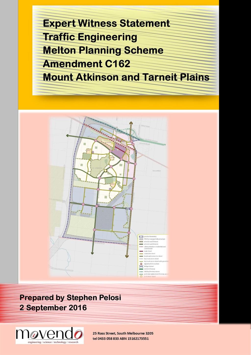
6 2. PROPOSED AMENDMENT C162 (MT ATKINSON AND TARNEIT PLAINS PSP) 2.1. OVERVIEW Amendment C162 (Mt Atkinson and Tarneit Plains PSP) has been prepared to facilitate future urban development over a land area of around 1,530 hectares. The area is bounded by the Western Freeway to the north, Hopkins Road to the east, Middle Road to the south and the Outer Metropolitan Ring (OMR) road reservation to the west. The proposed Amendment provides a framework for a combined residential and employment hub with approximately 6,700 dwellings (resulting in a projected population of around 18,500 people) and realisation of around 18,000 jobs. The Victorian Planning Authority (VPA) is the planning authority in respect of the Amendment. There is a set of key development objectives guiding the Mt Atkinson and Tarneit Plains PSP area including several that involve Transport and Movement. Objective 026 outlines the need to Provide an efficient road network to serve the state significant Western Industrial Node that ensures access is delivered to the strategic arterial road network to be delivered by VicRoads, and in particular to Hopkins Road. There is also a strong emphasis on sustainable transport modes. In Appendix B of the PSP document there are a number of Mt Atkinson Specialised Town Centre Design Principles listed. Principle 5 under the topic Connecting the Region describes an objective to Design the town centre to prioritise pedestrian and cyclist access and movement to and within the town centre. In support of this objective, the PSP highlights the need to provide strong connections and continuous paths of travel to, from and within the town centre to promote walking and cycling, including to Greigs Road, the Mt Atkinson volcanic cone, conservation reserves, and the Kororoit Precinct DESIGN PRINCIPLES & RELEVANT GUIDELINE DOCUMENTS This report examines three traffic engineering matters in relation to the transport network proposed under Amendment C162 (Mt Atkinson and Tarneit Plains PSP). It is therefore relevant, when assessing the adequacy of elements within the transport network, to first understand the principles used in designing road networks both as part of a precinct structure planning process and, more broadly, by reference to well-established traffic engineering design guidelines. A number of guideline documents exist to inform the planning of transport networks in growth areas two of which are particularly relevant in this Mt Atkinson and Tarneit Plains PSP context. These two guideline documents are: The Precinct Structure Planning Guidelines produced by the State Government s former Growth Areas Authority in 2009 (and revised in 2013). The November 2015 VicRoads working document known as Guidance for Planning Road Networks in Growth Areas. Austroads has also published guidance to help inform bicycle and pedestrian network planning and intersection design both are relevant to Mt Atkinson and Tarneit Plains PSP. Austroads is the association of Australasian road transport and traffic agencies. One of the guides published by Austroads deals with provisions for pedestrians, as part of road design. It is known as Guide to Road Design Part 6A: Pedestrian and Cyclist Paths. With respect to intersection design, Austroads has published the Guide to Road Design Part 4A: Unsignalised and Signalised Intersections. Finally, Austroads has also published a research report examining pedestrian-cyclist conflict on shared paths and footpaths the report is titled AP-R287/06 Pedestrian-Cyclist Conflict Minimisation on Shared Paths and Footpaths. A discussion on each of the above five documents is presented in the sections that follow. 2
7 2.2.1 GROWTH AREAS AUTHORITY PRECINCT STRUCTURE PLANNING GUIDELINES; PART TWO PREPARING THE PRECINCT STRUCTURE PLAN Part Two of the guidelines Preparing the Precinct Structure Plan (hereinafter referred to as the PSP guidelines ) provides a step-by-step guide to preparing a Precinct Structure Plan in Melbourne s growth areas such as Mt Atkinson and Tarneit Plains. The PSP guidelines define 7 key elements to inform the preparation of a design for a precinct: 1. Image and character; 2. Housing; 3. Employment and town centres; 4. Community facilities; 5. Open space and natural systems; 6. Transport and movement, and; 7. Utilities and energy. There are 15 standards identified for Element Six (Transport and movement) the most relevant for this report is standard S9: Standard S9 Marked bicycle lanes are provided on all collector streets. On all arterial roads, provide a shared bicycle/footpath (segregated where possible) and on road bicycle lanes wherever possible VICROADS GUIDANCE FOR PLANNING ROAD NETWORKS IN GROWTH AREAS This VicRoads document is currently a working document. It nonetheless provides insights into road elements that are of interest to VicRoads. Importantly it is broadly consistent with the road network planning principles outlined in the Growth Areas Authority (now Victorian Planning Authority) Precinct Structure Planning Guidelines. It is relevant to note, when considering the bicycle and pedestrian cross-sectional elements of arterial roads, that VicRoads advises as follows: Primary Arterials Recommended Bicycle/Pedestrian Features (section 3.3, page 16) Separate footpath and two-way off road bicycle paths to be provided on both sides of the road. Footpath to be provided adjacent to the property frontage or loop road i.e. outside road reservation. Providing a footpath further away from an arterial road can be considered improving amenity for pedestrians. Such an arrangement will require the provision of access/crossing points for users to enable safe passage to access Primary Arterial intersections. In the absence of a loop road the footpath is also to be accommodated within the road reservation, adjacent to the two-way off road bicycle path. Secondary Arterials Recommended Bicycle/Pedestrian Features (section 3.3, page 17) Separate footpath and two-way off road bicycle paths to be provided on both sides of the road, complemented with a high level-of-service at intersections to enable pedestrians and cyclists to maintain their overall journey continuity and quality. If additional space is required within the secondary arterial road reservation, then the footpath could be provided adjacent to the property frontage or loop road i.e. outside the road reservation. Such an arrangement will require the provision of access/crossing points for users to enable safe passage to public transport located along secondary arterials as well as to intersections. 3
8 2.2.3 AUSTROADS GUIDE TO ROAD DESIGN PART 6A: PEDESTRIAN AND CYCLIST PATHS This Austroads Guide outlines appropriate conditions applicable to the adoption of shared or separated bicycle facilities. The key recommendations are as follows: Figure 2.1, Section (page 7): Path volumes suggested in order to limit the incidence of conflict between users (significantly lower than the capacity of the principal path types) Shared paths are recommended when pedestrian and cyclist volumes during peak periods on a typical day are low. (Low demand is defined as Infrequent use of path less than 10 users per hour). Shared paths are not recommended when demand is (in both directions of travel) more than 50 users per hour Section 3.4 (pages 10-11): A shared use path may be appropriate where: demand exists for both a pedestrian path and a bicycle path but where the intensity of use is not expected to be sufficiently great to provide separate facilities an existing low-use footpath can be modified to provide for cyclists by satisfying legal requirements and as necessary upgrading the surface, width and kerb ramps there is an existing road nearby which caters well for faster cyclists (e.g. has on-road bicycle lanes), to limit the extent of user conflict on the shared path. Section 3.4 (page 11): A significant issue associated with shared use paths is the variety of users who display various characteristics that can lead to conflict between them. These characteristics include differences in speed, space requirements, age, user expectation (as some users expect exclusive or priority use) and predictability (e.g. cyclists, pedestrians walking dogs, roller bladers, and skateboard riders). Section 3.5 (page 12): A separated path may be appropriate where there is a significant volume of both cyclists and pedestrians such that shared use would lead to safety and operational problems. These situations typically arise in areas that attract high pedestrian and cyclist recreational or commuting movements (e.g. foreshore promenades and major inner city bridges). Commentary 5 (page 108): There is potential for conflict between the various users of a shared use path. To minimise this, a shared use path design should be to a high standard which provides adequate sight distance between cyclists and other users. It should desirably also provide a clear zone adjacent to the path to enable cyclists to safely run off the path to escape an incident (e.g. potential head-on collision with another cyclist; entanglement with a dog leash or evasive action to avoid a dog that is off the leash). Widths of 4.0 metres or more may be required where the numbers of cyclists and pedestrians are high or there is a high probability of conflict between users (e.g., people walking dogs, roller bladders and skaters, etc.). 4
9 2.2.4 AUSTROADS RESEARCH REPORT AP-R287/06 PEDESTRIAN-CYCLIST CONFLICT MINIMISATION ON SHARED PATHS AND FOOTPATHS Table 2.1, Section (page 5) Key findings from this research report with respect to shared paths are as follows: Pedestrian-cyclist conflict is common with significant volume of cyclists and pedestrians or a mix of recreational pedestrians and commuting cyclists Level of Service for cyclists can be poor where interference by other path users results in slower speeds Shared paths are beneficial to a range of path users but need to be managed effectively Appropriate with modest numbers of pedestrians and cyclists It is important that the path s design is suitable for its use and demand, that authorities adequately monitor users behaviour on the path, and that the connections between path, road and driveways are carefully considered AUSTROADS GUIDE TO ROAD DESIGN PART 4A: UNSIGNALISED AND SIGNALISED INTERSECTIONS This guide provides insights for the design of intersections. Sections 3.1 and 3.2 (page 15) This part of the Austroads Guide identifies that it is fundamental to the safety of intersections that drivers approaching in all traffic streams are able to: recognise the presence of an intersection in time to slow down or stop in a controlled and comfortable manner see vehicles approaching in conflicting traffic streams and give way where required by law or avoid a crash in the event of a potential conflict. Intersection safety performance is therefore largely dependent upon adequate sight distance in relation to both horizontal and vertical geometry for all drivers approaching and entering the intersection. Consequently, sight distance is a key consideration in the location and design of intersections and adequate sight distance at proposed intersections and remodelled intersections must be achieved when developing the horizontal and vertical alignments of new and upgraded roads, as is the case for proposed intersection IT05 in the Mt Atkinson and Tarneit Plains PSP. The types of sight distance that must be provided for vehicles in the design of all intersections include: approach sight distance (ASD) safe intersection sight distance (SISD) minimum gap sight distance (MGSD) On relatively flat terrain (where vertical alignment is unlikely to be an issue) the placement of intersections on horizontal curves typically achieves the most favourable sight distance outcomes when the junction occurs at the midpoint of the curve segment. This is illustrated in Figure 1. 5
10 Figure 1: SISD model for minor roads intersecting on the outside of horizontal curves (extract from Austroads Guide to Road Design Part 4A Figure 3.3, page 23) 6

11 2.3. LOCATION Amendment C162 applies to land shown in Figure 2, bounded by the Western Freeway to the north, the Outer Metropolitan Ring Road reservation to the west, Middle Road to the south and Hopkins Road to the east. The precinct is located approximately 34 kilometres to the west of the Melbourne CBD. Figure 2: Land affected by the amendment 7
12 2.4. THE TRANSPORT NETWORK REGIONAL TRANSPORT MODELLING The VPA did not undertake any transport modelling to specifically take account of the development scenario envisaged under the Mt Atkinson and Tarneit Plains PSP (Amendment C162). Instead, the VPA commissioned Jacobs consultants to review the suitability of using existing Victorian Integrated Transport Model (VITM) runs previously developed for either the PSP 1099 Rockbank, or PSP 1078 Plumpton and PSP 1080 Kororoit processes. Specifically, the VPA requested Jacobs views on whether those model runs would be suitable for the purposes of assessing the transport needs of the Mt Atkinson and Tarneit Plains PSP. Jacobs findings were included in a report titled PSP 1082 Mt Atkinson and PSP 1085 Tarneit Plains Transport Modelling Assessment dated 4 July Jacobs concluded that the most suitable existing version of VITM to use for assessing the traffic impacts in and around the Mt Atkinson and Tarneit Plains PSP is the Rockbank model. Jacobs assessed that the Rockbank model s 2046 scenario included employment, population and school enrolment land use inputs that would generate approximately similar traffic volumes. Jacobs also concluded that the transport zone system, road and Public Transport networks are a fair representation of what is currently planned by VPA in the Mt Atkinson and Tarneit Plains PSP. In its report, Jacobs recognised that there are no existing model runs suitable for assessing the Mt Atkinson and Tarneit Plains PSP at In order to create this 2026 scenario Jacobs indicated that it would require: Coding the 2026 road network Inputting the correct land use assumptions In summary, the conclusion reached by Jacobs, in its report, was that the preferred model to use is 2046 Rockbank model as it includes a better representation of 2046 population, employment and school enrolments within the Mt Atkinson and Tarneit Plains PSPs (compared with other model runs). However, the 2026 road network coded in the Rockbank VITM model is reflective of the demographic assumption of no development in Mt Atkinson and Tarneit Plains. Essentially, only existing roads are coded in the 2026 model, namely Hopkins Road, Greigs Road and Troups Road. Jacobs concluded that the 2026 road network is not suitable to test the proposed development within Mt Atkinson as there will be population and employment in zones that are not connected to the road network KEY FINDINGS FROM THE REGIONAL MODELLING The Jacobs report concluded that the 2046 Rockbank model is a fair representation of the land use and transport networks planned for the Mount Atkinson and Tarneit Plains PSP. It also concluded that whilst there are differences in the land use assumptions they are not likely to result in a significantly different distribution of traffic across the planned road network. The Jacobs report also determined that while there is capacity in the planned internal road network to service the proposed development; the surrounding arterial road network is approaching capacity at 2046, particularly along Hopkins Road around the Western Freeway and Boundary Road. It commented that Even without any trips being attracted to or from Mt Atkinson the road network has a number pinch points, particularly on Hopkins Road and at the southern end of the PSP around Boundary Road. The pinch points highlighted by Jacobs are shown in Figure 3. Importantly, Jacobs stated that the lack of a 2026 VITM model suitable for use means that conclusions must be drawn from the 2046 model. Based on the assumption of a 75% build out at 2026 it is recommended that both Hopkins Road and Greigs Road be upgraded to 4-lane arterials by
13 Figure 3: 2026 AM Peak Period Volume to Capacity Ratios (extract from July 2016 Jacobs Transport Modelling Assessment document Figure 14, page 26) As can be seen in Figure 3, the Jacobs report involved examination of Volume-Capacity (VC) ratios across the modelled road networks to determine the suitability of proposed network arrangements. VC ratios indicate the approximate level of congestion on links in the road network, by comparing the forecast volume of vehicles using a link by the link s theoretical capacity. Thus, VC ratios exceeding 0.8 and approaching 1 (those coloured orange, red and black in Figure 3) represent road links approaching their realistic capacity. Jacobs defined five VC levels each with an associated traffic condition rating as given in Table 1. 9

14 Table 1: VC ratios and associated forecast congestion levels In summary, the VC ratios obtained for the AM peak for the 2026 reference case model show that even without any trips being attracted to or from Mt Atkinson / Tarneit Plains the road network has a number pinch points, particularly on Hopkins Road and Jacobs recommended that, based on the assumption of a 75% build out at 2026, both Hopkins Road and Greigs Road be upgraded to 4-lane arterials by OTHER MODELLING The VPA commissioned Cardno to undertake intersection analysis at the northern end of Hopkins Road using specialist software package SIDRA. The two intersections examined were Hopkins Road at the Western Freeway and Sheahan Road/Meskos Road respectively (IT01 & IT02 as denoted in the PSP documentation). The Cardno assessment did not take into consideration the interim intersection requirements in Instead, intersection analysis of IT01 and IT02 was only undertaken for the ultimate 2046 timeframe (using 2046 Jacobs traffic volumes as a starting point with some adjustments). This analysis concluded that the two intersections would operate outside of capacity if constructed in accordance with VPA guidelines resulting in congestion at the intersections during peak hours. The analysis did not take into consideration the interaction between IT01 and IT02 (which are closely spaced) each intersection was assessed independent of the other. Furthermore, the analysis did not take account of the interaction between Hopkins Road traffic and the existing nearby at-grade Melbourne to Ballarat railway line, primarily used at present for V-line services. The Victorian Government recently announced funding to duplicate this line (with ultimate electrification in the future), which will result in increased services and incidences of boom gates being down (intermittently closing Hopkins Road). Cardno concluded that a 3-lane cross-section for Hopkins Road in each direction is appropriate for the ultimate 2046 traffic volumes and that the majority of traffic issues are expected to occur on the side roads at IT01 and IT02. 10
15 3. MELTON CITY COUNCIL ISSUES The three issues that I have been requested to examine include: 1. Intersections IT01 & IT02 Justification for geometric and operational adequacy of these intersections 2. Road cross sections for primary and secondary arterials treatment of pedestrian and bicycle facilities 3. Intersection IT05 Identification of a preferable location from a traffic engineering perspective Each is discussed in more detail below INTERSECTIONS IT01 & IT02 DESIGN ADEQUACY STATUS INTERSECTIONS IT01 & IT02 Intersections IT01 and IT02 are located on Hopkins Road just south of the Western Freeway. Hopkins Road is identified in the Mount Atkinson / Tarneit Plains PSP as an arterial road with an ultimate 6-lane cross-section. Hopkins Road is an existing north-south road, with a 2-lane cross-section, which already experiences some peak period congestion at its interchange with the Western Freeway. Traffic modelling and intersection analyses of the proposed transport network was not provided during the PSP exhibition stage, leading to uncertainties as to whether the proposed transport network will be effective. Some transport assessment has been made available to Council post-exhibition, in the form of reports by Jacobs and Cardno consultants COUNCIL S POSITION I am instructed that Council is concerned that the VPA has not provided sufficient traffic modelling and/or assessments to demonstrate that the proposed road network can accommodate the forecast traffic. More specifically Council is concerned at the ability of the two closely spaced intersections on Hopkins Road to effectively function in the interim as the key entry/exit points within the northern part of the PSP area. The specific area of concern, that has been highlighted by the Council, is the north-eastern end of the PSP, as shown in Figure 4. This is the location where there are two closely spaced intersections IT01 and IT02. Intersection IT01 serves the west bound on and off ramps to the Western Freeway. This intersection will have a regional role providing access to residential and employment areas south of the freeway (including Mt Atkinson and Tarneit Plains PSP and Melton and Wyndham growth areas) and access north of the freeway to residential and employment areas within Plumpton and Kororoit PSPs (proposing a combined population of around 54,000 people). Intersection IT02 is proposed to serve the Mt Atkinson Specialised Town Centre area (north of the railway line), including the proposed rail station and the Warrawee PSP. The land wedged between the freeway, Outer Metropolitan Ring Road, rail line and Hopkins Road, which includes the Mt Atkinson Specialised Town Centre area (north), is reliant on IT01 & IT02 for primary access and egress. I am instructed that Council is concerned that intersections IT01 & IT02 will not provide reliable connections to allow north-south movement. I am also instructed that Council have proposed to VPA that a connector road (and road bridge over the Melton rail corridor) be provided from IT05 to north of the rail corridor to provide connectivity to the town centre north of the rail line in the event that IT01 and IT02 are not able to operate satisfactorily. The suggested alignment for the new connector and road bridge is shown in Figure 5. 11


 Figure 5:")

16 Figure 4: Precinct Infrastructure Plan at Northern End of Mt Atkinson & Tarneit Plains Precinct Structure Plan (extract from April 2016 PSP document Plan 13, page 68) Potential bridge (road over rail) Figure 5: Indicative alignment of possible road over rail bridge (City of Melton Proposal) 12
17 3.1.3 RELEVANT MATTERS FOR CONSIDERATION 1. The Transport Modelling Assessment for the Mt Atkinson & Tarneit Plains Precinct Structure Plan (undertaken by Jacobs consultants on behalf of the VPA) identified that in 2046 the Rockbank Model is a fair representation of the land use and transport networks planned for the Mount Atkinson and Tarneit Plains PSP. Jacobs also concluded that the 2026 road network is not suitable to test the proposed development within Mt Atkinson as there will be population and employment in zones that are not connected to the road network. 2. Accordingly, Jacobs indicated that the lack of a 2026 VITM model suitable for use means that conclusions must be drawn from the 2046 model. On this basis, Jacobs recommended that both Hopkins Road and Greigs Road be upgraded to 4-lane arterials by 2026, based on the assumption of a 75% build out at The traffic volume forecasts prepared by Jacobs consultants (based on the Rockbank Model ) have revealed that Hopkins Road will rapidly reach arterial road traffic levels, with an estimated traffic volume in 2026 in excess of 20,000 vehicles per day in the vicinity of the Western Freeway. This growth in traffic occurs even without any trips being attracted to or from most of the Mt Atkinson / Tarneit Plains PSP area. Under the Planning Scheme, a road carrying 20,000 vehicles per day is an arterial. 4. Intersection analysis at IT01 and IT02 for the ultimate 2046 timeframe was undertaken by Cardno on behalf of VPA (using 2046 Jacobs traffic volumes as a starting point with some adjustments). This analysis concluded that the two intersections would operate outside of capacity if constructed in accordance with VPA guidelines resulting in congestion at the intersections during peak hours. The analysis did not take into consideration the interaction between IT01 and IT02 (which are closely spaced) each intersection was assessed independent of the other. In addition, the analysis has not considered the interaction between Hopkins Road traffic and the existing nearby at-grade Melbourne to Ballarat railway line, primarily used at present for V-line services. The Victorian Government recently announced funding to duplicate this line (with ultimate electrification in the future), which will result in increased services and incidences of boom gates being down (intermittently closing Hopkins Road). 5. Cardno concluded that a 3-lane cross-section for Hopkins Road in each direction is appropriate for the ultimate 2046 traffic volumes and that the majority of traffic issues are expected to occur on the side roads at IT01 and IT The Cardno report did not take into consideration the interim intersection requirements by CONCLUSION The traffic volume forecasts prepared for Hopkins Road demonstrate that the corridor will reach a traffic volume in excess of 20,000 vehicles per day by 2026 just south of the Western Freeway (even without any explicit traffic contribution from most of the Mt Atkinson & Tarneit Plains PSP area). The intersection modelling for IT01 and IT02 has been undertaken only for 2046 but not for The absence of 2026 traffic modelling for these intersections (that appropriately incorporates interaction between the two sites and the nearby Melbourne to Ballarat railway line) makes it difficult to confidently predict interim requirements for IT01 and IT02. Additional modelling is required to demonstrate what intersection layouts will be required to accommodate the forecast traffic. 13
 and Figure 7 (secondary arterial).")
 all of which feature the provision of a 1.")
18 3.2. ROAD CROSS SECTIONS FOR PRIMARY AND SECONDARY ARTERIALS STATUS ROAD CROSS SECTIONS The proposed design of pedestrian and bicycle facilities on primary and secondary arterials is documented in Appendix D of the Mt Atkinson & Tarneit Plains PSP and reproduced in Figure 6 (primary arterial) and Figure 7 (secondary arterial). The primary arterial cross section shows the two-way bike path and pedestrian path joined on the opposite side to the Local Frontage Road. There are 6 variations to the proposed secondary arterial cross section (only one of which is shown in Figure 7) all of which feature the provision of a 1.5-metre wide on-road bike lane in each direction. Figure 6: Proposed Cross Section Primary Arterial Road 6 lane (extract from Mt Atkinson & Tarneit Plains Precinct Structure Plan Appendix D, page 99) Figure 7: Proposed Cross Section Secondary Arterial Road Residential (extract from Mt Atkinson & Tarneit Plains Precinct Structure Plan Appendix D, page 93) 14
19 3.2.2 COUNCIL S POSITION I am instructed that Council is not supportive of joining the two-way bike path and pedestrian path on the opposite side to the Local Frontage Road, as proposed by VPA and shown on the Primary Arterial Road cross sections. Council s preference is to provide separation between the two-way bike path and pedestrian path. The cross section in Figure 8 is proposed by Council as an alternative for the Primary Arterial Road cross section shown in the PSP. Figure 8: Council-Preferred Cross Section Primary Arterial Road 6 lane I am also instructed that Council is not supportive of providing on road bike lanes, as proposed by VPA, on Secondary Arterial Roads. Council s preference is to provide two way off road bicycle paths on each side of the road reserve, in accordance with the recommended cross section for Secondary Arterials in the VicRoads Growth Area Network Planning Guidance & Policy Principles (Section 4.5) document. Cross sections for Secondary Arterial Roads are to be amended to provide two way off road bicycle paths on each side of the road reserve, in accordance with the recommended cross section for Secondary Arterials in the VicRoads Growth Area Network Planning Guidance & Policy Principles (Section 4.5) document. The cross section in Figure 9 is proposed by Council as an alternative for the treatment of bike lanes on Secondary Arterial Roads in contrast to the on road bike lanes shown in the PSP. The cross section in Figure 9 features two way off road bicycle paths in each direction. Figure 9: Council-Preferred Cross Section Secondary Arterial Road 15
20 3.2.3 RELEVANT MATTERS FOR CONSIDERATION 1. Cyclist and pedestrian use of pathways on primary and secondary roads is expected to be high consistent with the intent of the Design Principles in the PSP particularly Principle 5 (under the topic Connecting the Region ) which describes an objective to Design the town centre to prioritise pedestrian and cyclist access and movement to and within the town centre. In support of this objective, the PSP highlights the need to provide strong connections and continuous paths of travel to, from and within the town centre to promote walking and cycling, including to Greigs Road, the Mt Atkinson volcanic cone, conservation reserves, and the Kororoit Precinct. 2. The PSP guidelines define 7 key elements to inform the preparation of a design for a precinct, one of which Element Six involves Transport and Movement. There are 15 standards identified for Element Six the most relevant for this context is standard S9: Marked bicycle lanes are provided on all collector streets. On all arterial roads, provide a shared bicycle/footpath (segregated where possible) and on road bicycle lanes wherever possible. 3. The Mt Atkinson & Tarneit Plains PSP includes a road hierarchy with cross-sectional details provided at Appendix D. The PSP hierarchy of roads (in order of decreasing importance) is Primary Arterial, Secondary Arterial, Connector and Local Access Street. The cross sections shown in Appendix D for primary arterials and connectors both feature dedicated off road bike paths. However, the various secondary arterial cross sections feature on road bike lanes. This represents an inconsistency in the treatment of cyclists with an undesirable practical consequence. Specifically, it would force a user moving up the hierarchy of roads to cross between off- and on-road facilities. This means that cyclists would experience a reduction in the level of protection when travelling from a fully separated off-road bike facility on a connector street to a more exposed on-road facility on a secondary arterial road and finally back to full protection in the off-road bike path context found on the primary arterial roads. The hierarchy of roads is reproduced in Figure The VicRoads working document Guidance for Planning Road Networks in Growth Areas recommends that on Primary Arterials there should be separate footpath and two-way off road bicycle paths on both sides of the road. On Secondary Arterials the document recommends separate footpath and two-way off road bicycle paths to be provided on both sides of the road. 5. Austroads Guide to Road Design Part 6A: Pedestrian and Cyclist Paths outlines appropriate conditions applicable to the adoption of shared or separated bicycle facilities. Shared paths are recommended when pedestrian and cyclist volumes during peak periods on a typical day are low. (Low demand is defined as Infrequent use of path less than 10 users per hour). Shared paths are not recommended when demand is (in both directions of travel) more than 50 users per hour. Furthermore, a separated path may be appropriate where there is a significant volume of both cyclists and pedestrians such that shared use would lead to safety and operational problems. These situations typically arise in areas that attract high pedestrian and cyclist recreational or commuting movements which is the logical and desired outcome for the proposed cyclist and pedestrian facilities on the primary and secondary arterials in the Mt Atkinson & Tarneit Plains PSP. 6. Austroads Research Report AP-R287/06 Pedestrian-Cyclist Conflict Minimisation on Shared Paths and Footpaths identifies that pedestrian-cyclist conflict is common on shared paths with significant volume of cyclists and pedestrians or a mix of recreational pedestrians and commuting cyclists. It also identifies that shared paths are only appropriate with modest numbers of pedestrians and cyclists. 16

21 Figure 10: Proposed Road Network Plan (extract from Mt Atkinson & Tarneit Plains Precinct Structure Plan Plan 9, page 52) 17
22 3.2.4 CONCLUSION The adoption of cross sections for Primary Arterial roads as currently proposed in the PSP (where two-way bike path and pedestrian path are joined) is inconsistent with good design guidance for facilities that are expected to be well utilised. Similarly, the provision of on road bike lanes on Secondary Arterial roads is inconsistent with published design guidance. The Council-preferred separation of the two-way bike path and pedestrian path on the opposite side to the Local Frontage Road on the Primary Arterial cross section (as shown indicatively in Figure 8) is consistent with the desired design outcome to achieve separation of cyclist and pedestrian facilities as envisaged by relevant VPA, VicRoads and Austroads guidelines. In addition, the provision of two-way off road bicycle paths to be provided on both sides of Secondary Arterial roads (as shown indicatively in Figure 9) is consistent with the desired design outcome of providing cyclists full separation from motorised vehicles as envisaged by the same set of guidelines INTERSECTION IT05 IDENTIFICATION OF A PREFERABLE LOCATION STATUS INTERSECTION IT05 Intersection IT05 is located at the junction of road segments RD01 and RD02 with a new North-South Connector Road, as shown in Figure 11 (functional concept) and Figure 12 (broader context). This location is along a large radius horizontal curve. The PSP currently proposes to locate intersection IT05 on land at 263 Greigs Road. RD01 is the realigned Greigs Road between the Outer Metropolitan Ring Road (OMR) and the proposed western-most North-South connector street. RD02 is the realigned Greigs Road between the western-most North- South connector street and the intersection with another North-South Connector Road (IT06) that provides access into the specialised town centre. The identification of a preferable location for IT05, from a traffic engineering perspective, needs to take into consideration geometric design standards COUNCIL S POSITION I am instructed that Council wishes to move IT05 towards the north-west to maintain road segment RD01 within the existing 60m Greigs Rd road reserve (minimising land purchase requirements for this road segment). Moving IT05 towards the north-west would result in it being located on land at 289 Greigs Road. This change also allows the proposed western-most North-South connector street to be straightened (made more perpendicular) and to improve access to allow earlier commencement of development. The shift towards the north-west also removes the undevelopable triangle of land (shown in yellow in Figure 11) RELEVANT MATTERS FOR CONSIDERATION 1. The position of IT05 near the centre of a large radius curve provides the necessary pre-conditions to achieve reasonable intersection sight distance outcomes (assuming relatively flat terrain). 2. A relocation of IT05 towards the north-west is likely to improve sight distance outcomes by virtue of moving the junction closer to the midpoint of the curve segment. 18
 (extract from Mt Atkinson & Tarneit Plains Precinct Structure Plan Plan 13, page 68) 3.")


23 Undevelopable land Figure 11: IT05 Indicative intersection layout (Cardno preliminary drawing CG TR-DG-2505) Figure 12: Conceptual location of IT05 along horizontal curve (arc on Greigs Rd) (extract from Mt Atkinson & Tarneit Plains Precinct Structure Plan Plan 13, page 68) CONCLUSION The indicative proposed location for IT05, as identified in the PSP, is reasonable on traffic engineering grounds. However, a shift of IT05 towards the north-west offers an improved traffic engineering solution by moving the intersection closer to the optimal location for sight distance considerations (the midpoint of the circular arc on Greigs Road) as well as allowing the cross roads to be aligned on a more perpendicular alignment. The shift towards the north-west offers the greater net community benefit in terms of safer intersection design and utilisation of land. 19
24 4. MY OPINION It is my opinion that there are a number of traffic matters that are not appropriately addressed in the Mt Atkinson and Tarneit Plains PSP. Having reviewed all relevant documentation, I have formed the views outlined below: 4.1. INTERSECTIONS IT01 & IT02 DESIGN ADEQUACY There has been insufficient modelling undertaken to confidently predict interim intersection requirements (2026) for IT01 and IT02. The absence of 2026 traffic modelling creates uncertainty with respect to the ability of the proposed road network of accommodating future traffic. Additional modelling is required to demonstrate what intersection layouts will be required to accommodate the forecast traffic. This modelling should appropriately incorporate interaction between the two closely spaced intersections (IT01 and IT02) as well as reflect the interaction between Hopkins Road and the nearby Melbourne to Ballarat railway line ROAD CROSS SECTIONS FOR PRIMARY AND SECONDARY ARTERIALS The Primary Arterial cross section should achieve separation of cyclist and pedestrian facilities both of which should be off-road. In addition, the Secondary Arterial cross section should provide two-way off road bicycle paths on both sides of roads and there should not be any on-road bicycle lanes INTERSECTION IT05 IDENTIFICATION OF A PREFERABLE LOCATION The indicative proposed location for IT05, as identified in the PSP, is reasonable on traffic engineering grounds. However, a shift of IT05 towards the north-west offers an improved traffic engineering solution by moving the intersection closer to the optimal location for sight distance considerations (the midpoint of the circular arc on Greigs Road) as well as allowing the cross roads to be aligned on a more perpendicular alignment. The shift towards the north-west offers the greater net community benefit in terms of safer intersection design and utilisation of land. 20
25 5. DECLARATION I have made all the inquiries that I believe are desirable and appropriate and no matters of significance which I regard as relevant have to my knowledge been withheld from the Panel. Signed Date: 2 September
26 APPENDIX A MATTERS RAISED BY PPV GUIDE TO EXPERT EVIDENCE 22
27 In accordance with PPV guidance for the preparation of expert evidence the following details are provided: (a) the name and address of the expert; Stephen Pelosi, Ground Floor 25 Ross Street, South Melbourne. (b) the expert's qualifications and experience; I am a director of movendo Pty Ltd and I have 30 years of experience in transport planning and traffic engineering in Australia, New Zealand, the Middle East, Asia, Latin America and the US. My full CV is attached as Appendix B. I completed a Bachelor of Engineering (Civil) at RMIT University in I have held senior executive positions in government and consulting firms and in these roles I have been responsible for the delivery of major transport projects and for the provision of strategic and business advice to governments, infrastructure providers and developers on land use/transport studies, multi-modal transport assessments, masterplanning new communities, detailed transport systems analysis, road safety assessments, transport demand forecasting, route planning, public transport studies and bicycle & pedestrian strategies. Of particular relevance to the Mt Atkinson and Tarneit Plains PSP, I have been involved with numerous transport and traffic assessments in support of urban design frameworks and structure plans for numerous communities in the Cities of Melton, Maribyrnong, Moonee Valley, Ballarat, Colac Otway, Melbourne, Hume, Shepparton, Glenferrie, Knox, Warrnambool, Kilmore, Surf Coast, Banyule, Mitchell, Nillumbik, Bendigo, Yarra, Mildura, Glen Eira and Bayside. I have also undertaken numerous traffic studies for private clients ranging from detailed facility design to analysis of infrastructure requirements for large development proposals in Australia, China and the Middle East. (c) a statement identifying the expert's area of expertise to make the report; My training and experience, as highlighted in my CV, including involvement with many major transport infrastructure and masterplanning projects in Victoria, Australia and internationally qualifies me to comment on the traffic matters outlined in this report. Through my career, I have had considerable involvement in transport infrastructure planning and design, including various public transport and rail projects (Craigieburn Rail Electrification, South Morang Rail Extension project, City Circle Tram, Box Hill tram extension in Melbourne), several road projects (Peninsula Link, Western Distributor, East West Link, Calder Freeway, Geelong Bypass in Victoria and the Western Sydney Orbital in New South Wales). I have also appeared, as expert traffic and transport witness, at numerous tribunal and panel hearings, EES/EIS hearings and planning scheme amendment hearings. In particular, I have appeared as witness for the Peninsula Link Freeway and East West Link projects in Melbourne, Bass Gas, Otway Gas, Calder Freeway and Geelong Bypass projects in Victoria and also prepared an Expert Witness Statement for the Victorian Desalination Plant EES. (d) a statement identifying any other significant contributors to the report and where necessary outlining their expertise; Not Applicable (e) all instructions that define the scope of the report (original and supplementary and whether in writing or oral); I have been requested by Melton City Council to express my expert opinion as to the traffic implications of various aspects associated with the design of the proposed future road network servicing Mt Atkinson and Tarneit Plains PSP. 23
28 (f) the identity of the person who carried out any tests or experiments upon which the expert has relied on and the qualifications of that person; Not Applicable (g) the facts, matters and all assumptions upon which the report proceeds; My report is based on a review of Amendment C162 to the Melton Planning Scheme, specifically the extent to which various transport network issues have been addressed in the incorporated document titled Mt Atkinson & Tarneit Plains Precinct Structure Plan. (h) reference to those documents and other materials the expert has been instructed to consider or take into account in preparing his or her report, and the literature or other material used in making the report; My report is based on a number of documents and other materials that I have been instructed to consider or take into account in preparing the report, as well as other documents that I have referenced in forming my opinions as outlined in the report. Mt Atkinson and Tarneit Plains PSP documents 1. Background report Mt Atkinson and Tarneit Plains PSP; April Mt Atkinson and Tarneit Plains PSP; April 2016 Council submission 3. Council submission on Mt Atkinson and Tarneit Plains PSP; 1 July 2016 Traffic documents 4. Transport Modelling Assessment report for the VPA by Jacobs; 4 July Cardno Consultants Advice Notice CAN002; Ultimate Traffic Modelling; 16 August Traffix Group Traffic Engineering Assessment Proposed Aurora Business Park; February VicRoads guidance for planning road networks in growth areas (working document); November 2015 Other documents 8. Precinct Structure Planning Guidelines produced by the State Government s former Growth Areas Authority Part Two Preparing the Precinct Structure Plan; 2009 (revised in 2013) 9. Austroads Guide to Road Design Part 6A: Pedestrian and Cyclist Paths 10. Austroads Research Report AP-R287/06 Pedestrian-Cyclist Conflict Minimisation on Shared Paths and Footpaths (2006) 11. Austroads Guide to Road Design Part 4A: Unsignalised and Signalised Intersections 24
29 (i) a summary of the opinion or opinions of the expert; It is my opinion that there are a number of traffic matters that are not appropriately addressed in the Mt Atkinson and Tarneit Plains PSP document. Having reviewed all relevant documentation, I have formed the views outlined below: INTERSECTIONS IT01 & IT02 DESIGN ADEQUACY There has been insufficient modelling undertaken to confidently predict interim intersection requirements (2026) for IT01 and IT02. The absence of 2026 traffic modelling creates uncertainty with respect to the ability of the proposed road network of accommodating future traffic. Additional modelling is required to demonstrate what intersection layouts will be required to accommodate the forecast traffic. This modelling should appropriately incorporate interaction between the two closely spaced intersections (IT01 and IT02) as well as reflect the interaction between Hopkins Road and the nearby Melbourne to Ballarat railway line. ROAD CROSS SECTIONS FOR PRIMARY AND SECONDARY ARTERIALS The Primary Arterial cross section should achieve separation of cyclist and pedestrian facilities both of which should be off-road. In addition, the Secondary Arterial cross section should provide two-way off road bicycle paths on both sides of roads and there should not be any on-road bicycle lanes. INTERSECTION IT05 IDENTIFICATION OF A PREFERABLE LOCATION The indicative proposed location for IT05, as identified in the PSP, is reasonable on traffic engineering grounds. However, a shift of IT05 towards the north-west offers an improved traffic engineering solution by moving the intersection closer to the optimal location for sight distance considerations (the midpoint of the circular arc on Greigs Road) as well as allowing the cross roads to be aligned on a more perpendicular alignment. The shift towards the north-west offers the greater net community benefit in terms of safer intersection design and utilisation of land. (j) a statement identifying any provisional opinions that are not been fully researched for any reason (identifying the reason why such opinions have not been or cannot be fully researched); Not Applicable (k) a statement setting out any questions falling outside the expert's expertise and whether the report is incomplete or inaccurate in any respect. In the process of preparing this report, I have not identified any questions outside of my area of expertise in traffic engineering and transport planning. I have visited the site, undertaken observations and reviewed relevant documentation assigned to me. I have also drawn on my 30 years of experience in traffic and transport planning. As a result of my deliberations, I have formed the views outlined in this report with respect to the traffic and transport implications of various aspects associated with Amendment C
30 APPENDIX B CURRICULUM VITAE 26
31 27
32 28
33 29
34 30
35 31
36 32
PROPOSED RESIDENTIAL SUBDIVISION
 PROPOSED RESIDENTIAL SUBDIVISION PART OF TARNEIT ROAD & 1121 DOHERTYS ROAD, TARNEIT Prepared For: TCG (RM) Developments Pty Ltd MARCH 2014 OUR REF: 16740R#1 PROPOSED RESIDENTIAL SUBDIVISION PART OF TARNEIT
Traffic and Transport Assessment
 Traffic and Transport Assessment Section 96 Residential Subdivision, Davis Road Tarneit CG120370 Prepared for Stockland Pty Ltd 19 February 2013 Document Information Prepared for Stockland Pty Ltd Project
Berwick Health and Education Precinct: Casey Amendment C207 (Part 1) Submission to Planning Panels Victoria
 Submission to Planning Panels Victoria") Berwick Health and Education Precinct: Casey Amendment C207 (Part 1) Submission to Planning Panels Victoria August 2018 CONTENTS 1 Executive summary... 1 2 Summary of the amendment... 2 3 Submission...
Berwick Health and Education Precinct: Casey Amendment C207 (Part 1) Submission to Planning Panels Victoria August 2018 CONTENTS 1 Executive summary... 1 2 Summary of the amendment... 2 3 Submission...
1 VicRoads Access Management Policies May 2006 Ver VicRoads Access Management Policies May 2006 Version 1.02
 1 VicRoads Access Management Policies May 2006 Ver 1.02 VicRoads Access Management Policies May 2006 Version 1.02 2 VicRoads Access Management Policies May 2006 Ver 1.02 FOREWORD FOR ACCESS MANAGEMENT
City of Perth Cycle Plan 2029
 Bicycling Western Australia s response City of Perth Cycle Plan 2029 2012-2021 More People Cycling More Often ABOUT BICYCLING WESTERN AUSTRALIA Bicycling Western Australia is a community based, not-for-profit
Response to further information request Ministry of Education Notice of Requirement (200 & 252 Park Estate Road)
") 21 Pitt Street PO Box 6345, Auckland 1141, New Zealand T: +64 9 300 9000 // F: +64 9 300 9300 E: info@beca.com // www.beca.com Auckland Council Private Bag 92300 Victoria Street West Auckland 1142 15 August
21 Pitt Street PO Box 6345, Auckland 1141, New Zealand T: +64 9 300 9000 // F: +64 9 300 9300 E: info@beca.com // www.beca.com Auckland Council Private Bag 92300 Victoria Street West Auckland 1142 15 August
21.07 TRANSPORT CONNECTIVITY AND INFRASTRUCTURE
 21.07 TRANSPORT CONNECTIVITY AND INFRASTRUCTURE 21.07-1 Connectivity and Choice Transport connectivity and mode choice are critical to achieving productive, sustainable and socially just cities. Travel
Strategy for Walking & Cycling Action Plan
 Strategy for Walking & Cycling Action Plan To achieve higher levels of walking and cycling activity, the destinations which people access have to be available within suitable distances and designed to
BROMPTON LODGE, CRANBOURNE PRECINCT STRUCTURE PLAN TRAFFIC ENGINEERING ASSESSMENT WOLFDENE PTY LTD PREPARED FOR
 BROMPTON LODGE, CRANBOURNE PRECINCT STRUCTURE PLAN TRAFFIC ENGINEERING ASSESSMENT PREPARED FOR WOLFDENE PTY LTD TRAFFIC ENGINEERING ASSESSMENT PRECINCT STRUCTURE PLAN AT BROMPTON LODGE, CRANBOURNE Document
EXECUTIVE SUMMARY Callan Park accommodates travel from a wide range of transport modes, including walking, cycling, bus and light rail.
 TRANSPORT AND ACCESS EXECUTIVE SUMMARY Callan Park accommodates travel from a wide range of transport modes, including walking, cycling, bus and light rail. Whilst there are some walking facilities within
Transit boulevard: A new road type for Sydney s Growth Centres
 Transit boulevard: A new road type for Sydney s Growth Centres Cleaver, M. A., de Roos, M. P., NSW Centre for Road Safety, Roads and Traffic Authority, NSW Collins, G., Network Services, Roads and Traffic
Traffic Modelling and Intersection Analysis
 City of Whittlesea 4-Sep-4 Traffic Modelling and Intersection Analysis Wollert Precinct Structure Plan \\aumelfp\projects\698\6. Draft Docs\6. Reports\4-9-4 Final Report.docx Revision 4-Sep-4 Prepared
Review of Guidelines for Cycleway Safety Fencing
 Review of Guidelines for Cycleway 1.0 PURPOSE 1.1 This document is meant to provide a review of available reference documents for determining appropriate fencing requirements for cycleway paths and shared
Minta Farm Berwick S96A Transport Impact Assessment
 Minta Farm Berwick S96A Transport Impact Assessment 170310TIA001I-F 4 October 2017 onemilegrid ABN: 79 168 115 679 (03) 9939 8250 1/59 Keele Street COLLINGWOOD, VIC 3066 www.onemilegrid.com.au DOCUMENT
Ormond & McKinnon Walks Response to Draft Glen Eira Community Plan
 Response to Draft Glen Eira Community Plan We would like to take this opportunity to thank Glen Eira City Council for the opportunity to comment on the Glen Eira Draft Community Plan. Below is an outline
gaf traffic 2015 capability statement
 gaf traffic 2015 capability statement www.gaftraffic.com.au INTRODUCING GAF TRAFFIC GAF Traffic is a people-centred traffic engineering consultancy serving new and existing projects in Western Australia.
Barwon Heads Road, Armstrong Creek Traffic Impact Assessment Prepared for: Newland Developers Pty Ltd
 892 990 Barwon Heads Road, Armstrong Creek Traffic Impact Assessment Prepared for: Newland Developers Pty Ltd JULY 2015 TABLE OF CONTENTS 1 INTRODUCTION... 1 1.1 BACKGROUND... 1 1.2 SCOPE... 1 1.3 AIM
March Maidstone Integrated Transport Strategy Boxley Parish Council Briefing Note. Context. Author: Parish Clerk 2 March 2016
 Context. Author: Parish Clerk 2 The Draft Integrated Transport Policy (DITS) sets out a vision and objectives, and identifies a detailed programme of interventions to support the Maidstone Borough Local
ONE SIZE DOESN T FIT ALL RECONCILING OVERLAPPING TRANSPORT NETWORKS IN A CONSTRAINED URBAN ENVIRONMENT
 One Size Doesn t Fit All S Corbett, C Chenery Page 1 ONE SIZE DOESN T FIT ALL RECONCILING OVERLAPPING TRANSPORT NETWORKS IN A CONSTRAINED URBAN ENVIRONMENT Authors/Presenters: Sam Corbett, Principal Transport
Growth Areas Authority 31 May Wyndham North Traffic Modelling and SIDRA Analysis
 Growth Areas Authority 31 May 213 Wyndham North Traffic Modelling and SIDRA Analysis AECOM Wyndham North Traffic Modelling and SIDRA Analysis Wyndham North Traffic Modelling and SIDRA Analysis Prepared
Exhibit 1 PLANNING COMMISSION AGENDA ITEM
 Exhibit 1 PLANNING COMMISSION AGENDA ITEM Project Name: Grand Junction Circulation Plan Grand Junction Complete Streets Policy Applicant: City of Grand Junction Representative: David Thornton Address:
1.5 On this basis it is fundamental that the Transport Strategy for the site focuses on the following key criteria,
 1.0 Introduction 1.1 The Transport Assessment has been prepared on behalf of Eon and Roger Bullivant Ltd in respect of the proposed mixed use sustainable urban extension of Drakelow Park. 1.2 The methodology
AUTOMATED AND ZERO EMISSION VEHICLES HOW THEY MIGHT RESHAPE OUR STREETS
 AUTOMATED AND ZERO EMISSION VEHICLES HOW THEY MIGHT RESHAPE OUR STREETS STURT ST BALLARAT WATERGARDENS TAYLORS LAKES SIMPSON ST YARRAVILLE CHAPEL ST SOUTH YARRA RINGWOOD STATION MONASH FREEWAY SA NSW VIC
WDA response to O'Brien summary of recommendations dated 4 September 2017
 WDA response to O'Brien summary of recommendations dated 4 September 2017 O'Brien recommendation 1. Incorporate sustainable solutions such as travel demand management, active traffic management, multimodal
Cycle traffic and the Strategic Road Network. Sandra Brown, Team Leader, Safer Roads- Design
 Cycle traffic and the Strategic Road Network Sandra Brown, Team Leader, Safer Roads- Design Highways England A Government owned Strategic Highways Company Department for Transport Road Investment Strategy
The Safe System Approach
 There are very few areas of public discussion and sentiment which generate as much consensus as road safety. Everyone wants safer roads for all users, and road safety is a key priority for governments,
E4 Cycle Route Exeter University to Redhayes Bridge. - Recommendations from Exeter Cycling Campaign
 E4 Cycle Route Exeter University to Redhayes Bridge - Recommendations from Exeter Cycling Campaign 1.0 Introduction Exeter Cycling Campaign has prepared this report to provide recommendations for Devon
Devonport City Cycling Network Strategy
 Devonport City Cycling Network Strategy 2010-2013 Devonport City Cycling Network Strategy Introduction In February 2010 a draft master plan for cycleways was presented to the community. The feedback received
GD 0043/18 ACTIVE TRAVEL STRATEGY
 GD 0043/18 ACTIVE TRAVEL STRATEGY 2018-2021 May 2018 Minister s Introduction There is strong evidence that regular physical activity reduces the risk of a range of health conditions. The best way to increase
Pakenham East PSP 1210
 Pakenham East PSP 1210 Victorian Planning Authority Traffic and Transport: Expert Witness Statement Final C May 28, 2018 Pakenham East PSP 1210 Project No: Document Title: Document No.: Revision: IS245200
City of Wayzata Comprehensive Plan 2030 Transportation Chapter: Appendix A
 A1. Functional Classification Table A-1 illustrates the Metropolitan Council s detailed criteria established for the functional classification of roadways within the Twin Cities Metropolitan Area. Table
Frome Street Bicycle Route
 The Adelaide City Council invites engagement from the community about Frome Street Bicycle Route Project Summary Adelaide City Council is seeking feedback on design options to construct bicycle facilities
MYTH-BUSTING IN MELBOURNE Left-turn Vehicle vs. Pedestrian Crashes At Signalised Intersections
 MYTH-BUSTING IN MELBOURNE Left-turn Vehicle vs. Pedestrian Crashes At Signalised Intersections Presentation by Mark O Brien AITPM Thursday 21 September 2017 Assumed Common Wisdom Our study commenced over
Minta Farm Precinct Structure Plan
 Minta Farm Precinct Structure Plan Concept Road Design Report Client: Victorian Planning Authority Project No. 161910 Final Report 05/10/17 1 st Floor 132 Upper Heidelberg Road Ivanhoe Vic 3079 PO Box
Ministry of Education Flat Bush School Notice of Requirement. Integrated Transportation Assessment Report. February 2016
 Ministry of Education Flat Bush School Notice of Requirement Integrated Transportation Assessment Report February 2016 TDG Ref: 12988-2 151105 ita flat bush.docx Ministry of Education Flat Bush School
Update June 2018 OUR 2017 PUBLIC ENGAGEMENT
 Update June 2018 Hi, Let s Get Wellington Moving (LGWM) is developing a Recommended Programme of Investment (RPI) that meets our programme objectives and supports the city s and region s growth. As part
STATEMENT TO PLANNING PANELS VICTORIA BY WILLIAM DE WAARD, TRAFFIC ENGINEER
 Amendment C228 to the Casey Planning Scheme Traffic Engineering Assessment Planning Panels Victoria Panel Hearing Date: Monday 16 th April, 2018 Report Date: 5 th April, 2018 Prepared for the Applicant:
Launceston's Transport Futures. Greater travel options for the people of Launceston
 Launceston's Transport Futures Greater travel options for the people of Launceston Final Draft 13 Jan 2014 1 Page Number Executive summary 3 What is Transport Futures? 4 Vision 6 Economy, access and liveability
5.0 Roadway System Plan
 Southwest Boise Transportation Study Page 16 5.0 Roadway System Plan The Roadway System Plan outlines roadway improvements in the Initial Study Area. It forecasts future deficiencies on the arterial system,
ENHANCED PARKWAY STUDY: PHASE 2 CONTINUOUS FLOW INTERSECTIONS. Final Report
 Preparedby: ENHANCED PARKWAY STUDY: PHASE 2 CONTINUOUS FLOW INTERSECTIONS Final Report Prepared for Maricopa County Department of Transportation Prepared by TABLE OF CONTENTS Page EXECUTIVE SUMMARY ES-1
Communiqué ABC Meeting #41 Cairns 2-3 August 2012
 Communiqué ABC Meeting #41 Cairns 2-3 August 2012 Esplanade shared path, Cairns Queensland The Australian Bicycle Council met in Cairns on 2-3 August 2012. Cairns Cycling Update Hellius Visser, Director
Using Computer Modelling to Identify Road Safety Risks Vecovski, P. 1, Mak, J. 1, Brisbane, G. 1
 Vecovski, P. 1, Mak, J. 1, Brisbane, G. 1 1 NSW, Roads & Traffic Authority Abstract Road safety practitioners have traditionally relied on current road standards and past experiences to manage road safety
2. Context. Existing framework. The context. The challenge. Transport Strategy
 Transport Strategy Providing quality connections Contents 1. Introduction 2. Context 3. Long-term direction 4. Three-year priorities 5. Strategy tree Wellington City Council July 2006 1. Introduction Wellington
MILTON ROAD LLF PROJECT UPDATE
 Greater Cambridge City Deal MILTON ROAD LLF PROJECT UPDATE 9 th May 2017 Project objectives Comprehensive priority for buses in both directions wherever practicable; Additional capacity for sustainable
High frequency bus services operating to Little Island; Creation of a new Park and Ride site and train station at North Esk;
 Cork County Council 7 th December 2018 Dear Adrian O Neill (aoneill@jbbarry.ie) The Transport and Mobility Forum, Cork (TMF) is a representative group of organisations who have a common interest in sustainable
4. Guided Bus Explained
 4. Guided Bus Explained Contents 1 INTRODUCTION... 2 Structure of this report... 2 2 KERB GUIDED BUS... 3 Overview... 3 Kerb guidance... 3 Figures Figure 2.1 Figure 2.2 Figure 2.3 Figure 2.4 Figure 2.5
VicRoads. Drysdale Bypass Overview Traffic Modelling Report
 Vics Drysdale Bypass Overview Traffic Modelling Report July 2017 Table of contents 1. Introduction... 1 1.1 Qualifications and Experience... 1 1.2 Instructions and Purpose of this Report... 1 1.3 Scope
RAA Submission to: The City of Adelaide Draft Integrated Movement Strategy Moving Adelaide
 RAA Submission to: The City of Adelaide Draft Integrated Movement Strategy 2012-22 Moving Adelaide May 2012 RAA Submission to the City of Adelaide Draft Integrated Movement Strategy 2012-22 Moving Adelaide
Phone: Ref No: 06/2018/0884
 Development Directorate Preston City Council Town Hall Lancaster Road Preston PR1 2RL FAO Ben Sandover Phone: 01772 533855 Email: david.allen@lancashire.gov.uk Ref No: 06/2018/0884 Date: 20 September 2018
Transportation Master Plan Advisory Task Force
 Transportation Master Plan Advisory Task Force Network Alternatives & Phasing Strategy February 2016 BACKGROUND Table of Contents BACKGROUND Purpose & Introduction 2 Linking the TMP to Key Council Approved
North West Non-Technical Summary of the Transport Assessment September 2011
 North West Non-Technical Summary of the Transport Assessment September 2011 Introduction This is a Non-Technical Summary of the findings of the Transport assessment work undertaken for the proposed North
DRAFT for a State Policy for Healthy Spaces and Places
 DRAFT for a State Policy for Healthy Spaces and Places 1 DRAFT State Policy for Healthy spaces and Places 1. Purpose To encourage the use and development of land that builds healthy communities through
City of Homewood Transportation Plan
 City of Homewood Transportation Plan Prepared for: City of Homewood, Alabama Prepared by: Skipper Consulting, Inc. May 2007 TABLE OF CONTENTS INTRODUCTION... 1 BACKGROUND INFORMATION... 1 EXISTING TRANSPORTATION
Regional Cycle Programme Update
 Agenda Item 10 (ii) Regional Cycle Programme Update Glossary Auckland Council Auckland Transport Cycle Action Auckland New Zealand Transport Agency Regional Cycle Network (AC) (AT) (CAA) (NZTA) (RCN) Executive
6. BREENS/GARDINERS/HAREWOOD INTERSECTION - SAFETY IMPROVEMENT PROJECT
 6. BREENS/GARDINERS/HAREWOOD INTERSECTION - SAFETY IMPROVEMENT PROJECT General Manager responsible: Officer responsible: Author: Jane Parfitt General Manager City Environment DDI 941 8656 Michael Aitken
PAEKĀKĀRIKI HILL ROAD / BEACH ROAD / SH1 INTERSECTION PROGRESS REPORT
 Chairperson and Committee Members ENVIRONMENT AND COMMUNITY DEVELOPMENT COMMITTEE 6 DECEMBER 2011 Meeting Status: Public Purpose of Report: For Decision PAEKĀKĀRIKI HILL ROAD / BEACH ROAD / SH1 INTERSECTION
Developing a Birmingham Transport Space Allocation policy. David Harris Transport Policy Manager Economy Directorate Birmingham City Council
 Developing a Birmingham Transport Space Allocation policy David Harris Transport Policy Manager Economy Directorate Birmingham City Council Birmingham s Sustainable Urban Mobility Plan Birmingham Connected
AUTOMATED AND ZERO EMISSION VEHICLES HOW THEY MIGHT RESHAPE OUR STREETS
 AUTOMATED AND ZERO EMISSION VEHICLES HOW THEY MIGHT RESHAPE OUR STREETS BACKGROUND: This study is a collaboration between Urban Circus (Visualisation) and Ethos Urban (Urban Design) Ideas were workshopped
PEDESTRIAN ACTION PLAN
 ATTACHMENT 2 CITY OF SANTA MONICA PEDESTRIAN ACTION PLAN CITY OF SANTA MONICA PEDESTRIAN ACTION PLAN This page intentionally left blank EXECUTIVE SUMMARY CHAPTER 1 EXECUTIVE SUMMARY Setting the Stage
DUNBOW ROAD FUNCTIONAL PLANNING
 DUNBOW ROAD FUNCTIONAL PLANNING Final Report August 3, 216 #31, 316 5th Avenue NE Calgary, AB T2A 6K4 Phone: 43.273.91 Fax: 43.273.344 wattconsultinggroup.com Dunbow Road Functional Planning Final Report
Clackamas County Comprehensive Plan
 ROADWAYS The County s road system permits the movement of goods and people between communities and regions, using any of a variety of modes of travel. Roads provide access to virtually all property. They
WELCOME TO OPEN HOUSE # 1 June 14, 2017
 Langstaff Road Weston Road to Highway 7 Class Environmental Assessment Study WELCOME TO OPEN HOUSE # 1 June 14, 2017 Please sign in and join our mailing list Purpose of Open House #1 & Study Area York
Chapter 2: Standards for Access, Non-Motorized, and Transit
 Standards for Access, Non-Motorized, and Transit Chapter 2: Standards for Access, Non-Motorized, and Transit The Washtenaw County Access Management Plan was developed based on the analysis of existing
Nottingham Cycle City Frequently Asked Questions
 Nottingham Cycle City Frequently Asked Questions About the scheme How much money is to be spent on cycling? And where is the money from? We have 6.1 million in Growth Fund which we will be investing directly
SCHEME DESIGN AND ENGINEERING
 THE NORTH SOMERSET COUNCIL (SOUTH BRISTOL LINK CLASSIFIED ROAD) SIDE ROADS ORDER 2013 THE NORTH SOMERSET COUNCIL (SOUTH BRISTOL LINK) COMPULSORY PURCHASE ORDER 2013 THE NORTH SOMERSET COUNCIL (SOUTH BRISTOL
4. ENVIRONMENTAL IMPACT ANALYSIS 9. TRANSPORTATION AND TRAFFIC
 4. ENVIRONMENTAL IMPACT ANALYSIS 9. TRANSPORTATION AND TRAFFIC 4.9.1 INTRODUCTION The following section addresses the Proposed Project s impact on transportation and traffic based on the Traffic Study
Derby Cycling Group, c/o 126, Station road, Mickleover, Derby, DE3 9FN. Date: 20 th November, 2018.
 Your Ref: Derby City Council Air Quality - Preferred Option Nov 2018 Derby Cycling Group, c/o 126, Station road, Mickleover, Derby, DE3 9FN Date: 20 th November, 2018. 1. Introduction: 1.1. Derby Cycling
102 Avenue Corridor Review
 February 26, 2015 102 Avenue Corridor Review Transportation Association of Canada Road Safety Engineering Award Submission for the City of Edmonton Introduction Transportation Association of Canada Road
Simulation Analysis of Intersection Treatments for Cycle Tracks
 Abstract Simulation Analysis of Intersection Treatments for Cycle Tracks The increased use of cycle tracks also known as protected bike lanes has led to investigations of how to accommodate them at intersections.
Works Approval Application. G.2 Traffic
 Works Approval Application G.2 Traffic RO097400.WAA.23.04.2018 Floor 11, 452 Flinders Street Melbourne VIC 3000 PO Box 312, Flinders Lane Melbourne VIC 8009 Australia T +61 3 8668 3000 F +61 3 8668 3001
Loughborough University Travel Planning
 Document Ti tle Client Name Loughborough University Travel Planning Loughborough University Travel Plan Executive Summary 2015-2020 23 December 2015 Loughborough University Travel Planning Project no:
COUNCIL POLICY NAME: COUNCIL REFERENCE: 06/119 06/377 09/1C 10llC 12/1C INDEX REFERENCE: POLICY BACKGROUND
 COUNCIL POLICY NAME: COUNCIL ADVISORY COMMITTEES - TERMS OF REFERENCE ISSUED: APRIL 3, 2006 AMENDED: NOVEMBER 27, 2006 NOVEMBER 23, 2009 JANUARY 11, 2010 DECEMBER 17, 2012 POLICY COUNCIL REFERENCE: 06/119
Douglas Land Use and Transportation Strategy (DLUTS) Summary. August 2013
 Summary. August 2013") Douglas Land Use and Transportation Strategy (DLUTS) Summary August 2013 Background Douglas is a large and popular residential suburb of approximately 30,000 persons on the periphery of Cork City along
Douglas Land Use and Transportation Strategy (DLUTS) Summary August 2013 Background Douglas is a large and popular residential suburb of approximately 30,000 persons on the periphery of Cork City along
HAMILTON BIKING PLAN OUR VISION: A BIKE FRIENDLY CITY
 HAMILTON BIKING PLAN 2015-2045 OUR VISION: A BIKE FRIENDLY CITY INTRODUCTION Biking as a travel option is experiencing a resurgence internationally and in New Zealand, growing as a familyfriendly and healthy
Daleston Masterplan Traffic & Transport Assessment
 ` Daleston Masterplan Job Number: CG111723 Daleston Masterplan Cardno Victoria Pty Ltd ABN 47 106 610 913 150 Oxford Street, Collingwood Victoria 3066 Australia Telephone: 03 8415 7777 Facsimile: 03 8415
University of Victoria Campus Cycling Plan Terms of Reference. 1.0 Project Description
 University of Victoria Campus Cycling Plan Terms of Reference 1.0 Project Description The Campus Cycling Plan, a first for the University, will provide a comprehensive and coordinated approach to support
Safe roads for cyclists: an investigation of Australian and Dutch approaches
 Safe roads for cyclists: an investigation of Australian and Dutch approaches Joel Docker 1 and Marilyn Johnson 2 1 Department of Civil Engineering, Monash University, Australia 2 Institute of Transport
Douglas Land Use and Transportation Study
 Douglas Land Use and Transportation Study Summary: Key: Yellow Box = key project information Green Box = project recommendations Grey Box = anticipated project outcomes Background: It is an objective of
At each type of conflict location, the risk is affected by certain parameters:
 TN001 April 2016 The separated cycleway options tool (SCOT) was developed to partially address some of the gaps identified in Stage 1 of the Cycling Network Guidance project relating to separated cycleways.
Speed Limits in the Hoddle Grid
 Speed Limits in the Hoddle Grid Recent History of speed limits March 2013 Docs # 7738485 1 Introduction Muncipalities have power to Erect speed limit signs BUT Municipalities DO NOT have the power to approve
Traffic Modelling Report
 CG150713 Prepared for Metropolitan Planning Authority 28 September 2015 Document Information Prepared for Metropolitan Planning Authority Project Name File Reference CG150713REP001F01.docx Job Reference
TRANSPORT AND MOVEMENT
 TRANSPORT AND MOVEMENT Movement Strategy Public Transport Cycling and Walking Road Network Parking Standards Transport Impact Assessments Traffic Management Policies DRAFT POOLBEG PLANNING SCHEME Movement
Technical note. 1. Introduction
 Project: A428 study - Phase 2 To: Adrian Shepherd Subject: Park & Ride site locations From: Atkins Date: Jun 3, 2016 cc: Ashley Heller 1. Introduction 1.1. Purpose of Technical Note The purpose of this
Chapter 7. Transportation. Transportation Road Network Plan Transit Cyclists Pedestrians Multi-Use and Equestrian Trails
 Chapter 7 Transportation Transportation Road Network Plan Transit Cyclists Pedestrians Multi-Use and Equestrian Trails 7.1 TRANSPORTATION BACKGROUND The District of Maple Ridge faces a number of unique
CITY OF SASKATOON COUNCIL POLICY
 ORIGIN/AUTHORITY Clause 1, Report No. 1-1980 and Clause 4, Report No. 22-1990 of the Works and Utilities Committee; Clause 6, Report No. 17-2004 of the Planning and Operations Committee; and Clause D5,
Determining bicycle infrastructure preferences A case study of Dublin
 *Manuscript Click here to view linked References 1 Determining bicycle infrastructure preferences A case study of Dublin Brian Caulfield 1, Elaine Brick 2, Orla Thérèse McCarthy 1 1 Department of Civil,
Route 7 Corridor Study
 Route 7 Corridor Study Executive Summary Study Area The following report analyzes a segment of the Virginia State Route 7 corridor. The corridor study area, spanning over 5 miles in length, is a multi
A127/A130 Fairglen Interchange Improvement Schemes. Information Leaflet February 2017
 A127/A130 Fairglen Interchange Improvement Schemes Information Leaflet February 2017 1 2 Foreword By Councillor Kevin Bentley Essex is continuing to grow as a vibrant economic hub and as a fantastic place
Harriet Fraser Traffic Engineering & Transportation Planning
 Appendix 5: Traffic Assessment 71 26 February 2015 Mr James Beban Senior Resource Consents Planner Cuttriss Consultants Ltd PO Box 30429 Lower Hutt PO Box 40170 Upper Hutt 5140 P 04 526 2979 M 027 668
PERSONALISED TRAVEL PLANNING IN MIDLETON, COUNTY CORK
 PERSONALISED TRAVEL PLANNING IN MIDLETON, COUNTY CORK Elaine Brick Principal Transport Planner AECOM Abstract Smarter Travel funding was awarded to the Chartered Institute of Highways and Transportation
Classification Criteria
 SCHEDULE D TO RECOMMENDED OFFICIAL PLAN AMENDMENT NO. 40 SCHEDULE C-4 Road Criteria Criteria Traffic Service Objective Land Service/Access Typical Daily Traffic Volume Flow characteristics Travel Speed
Ministry of Education Notice of Requirement, North City High School. Transportation Assessment Report. July 2010
 Ministry of Education Notice of Requirement, North City High School Transportation Assessment July 2010 PO Box 1261, Level 1, 7 Hardley Street Hamilton 3240 P: +64 7 839 550 www.tdg.co.nz New Zealand 10574ta_v6.doc
TRAFFIC STUDY GUIDELINES Clarksville Street Department
 TRAFFIC STUDY GUIDELINES Clarksville Street Department 9/1/2009 Introduction Traffic studies are used to help the city determine potential impacts to the operation of the surrounding roadway network. Two
TRANSPORTATION NEEDS ASSESSMENT
 TRANSPORTATION NEEDS ASSESSMENT A travel demand analysis was carried out to determine the operational issues and the potential benefit that adding traffic capacity would have on the road network. All the
Coquitlam Cross-town Bike Route Improving Bicycle Facilities in a Mature Suburban Environment
 Coquitlam Cross-town Bike Route Improving Bicycle Facilities in a Mature Suburban Environment Sarah Rocchi, Vice-President, Projects, Opus International Consultants (Main Presenter) Catherine Mohoruk,
8 PROPOSED ROUNDABOUT DUFFERIN STREET AND KING VAUGHAN ROAD INTERSECTION CITY OF VAUGHAN
 8 PROPOSED ROUNDABOUT DUFFERIN STREET AND KING VAUGHAN ROAD INTERSECTION CITY OF VAUGHAN The Transportation Services Committee recommends the adoption of the recommendation contained in the following report
Active Travel Strategy Dumfries and Galloway
 Active Travel Strategy Dumfries and Galloway Our Active Travel Strategy The agreed Interventions for Dumfries and Galloway Council s Local Transport Strategy includes an action to Develop an Active Travel
Traffic Engineering Assessment. Additional Traffic Modelling at Minta Farm PSP 11. Prepared for Victorian Planning Authority
 Additional Traffic Modelling at Minta Farm PSP 11 Prepared for Victorian Planning Authority Traffic Engineering Assessment Additional Traffic Modelling at Minta Farm PSP 11 Document Control Issue No. Type
Joint Response to the Department for Transport Consultation on the Station Champions Report on Better Rail Stations. February 2010
 Joint Response to the Department for Transport Consultation on the Station Champions Report on Better Rail Stations Joint Response to the Better Rail Stations Consultation This response has been prepared
CUERDEN TRANSPORT PROPOSALS
 1 CUERDEN TRANSPORT PROPOSALS The transport assessment, submitted with the Cuerden development planning application, looks at access to the site and the impact on the local road network in detail. This