SPRUCING UP YOUR ITS. Sheffield City Council - August Brent Collier Stephanie Cooper Ben Hallworth
|
|
|
- Griselda Dixon
- 5 years ago
- Views:
Transcription

1 SPRUCING UP YOUR ITS Sheffield City Council - August 2017 Brent Collier Stephanie Cooper Ben Hallworth 1
2 CONTENTS SPRUCING UP YOUR ITS... 1 Introduction... 3 SPRUCE Background... 3 Architecture... 4 Strategies... 4 Buses - WICKER / Inner Ring Road... 5 Stratagies... 6 Junction 1 Wicker / Nursery Street... 6 Junction 2 Wicker / Derek Dooley Way (Inner Ring Road)... 7 Junction 3 Wicker / Saville Street... 7 Overall Results... 8 Trams, Buses & Traffic - Manor Top Stratagies Aim 1 - Tram priority On City Road Aim 2 - traffic congestion ON Outer Ring Road Aim 3 - Compensation ON Ridgeway Road / Hurfield Road Results Aim 1 Results - Tram priority Aim 2 Results traffic congestion Outer Ring Road Aim 3 Results Tram Compensation
3 INTRODUCTION This paper will describe two different networks in Sheffield and how the SPRUCE system has been used to target various issues at each of them. These are just the Sheffield story on how they tackled the problems, they would not be the only way to tackle them; Both examples have balancing the requirements of an Outer/Inner Ring road traffic with the need to prioritise public transport movements across them. In Example 1 at the Wicker it is buses and in Example 2 at Manor Top it is both trams and buses. To tackle this Sheffield turned to the existing SPRUCE system, they needed to call on its ability to: Deal with the specificity of our problem (so many variables) Be developed and tested centrally Be flexible (if on street changes, it needs to change too) Talks to all the systems (and any we might have in the future) Can be improved upon (isn t a one stop shop) Collect data from anything and everything (whether that s detectors, google, etc) Sheffield has been using SPRUCE to give bus priority to approximately 200 sites for 10 years, and knew it had great capability so decided to explore its potential further. In brief SPRUCE is able to: Monitor junctions - a basis for making a range of informed timing interventions (or storing for historic data collection), Give and recover from priority to selective vehicles Tweak plans -- override normal UTC plans with different synchronized plans (e.g. 'priority' or 'compensation' plans), Raise cycle times - alter timings in a variety of different ways ('extensions', 'recalls', 'holds', 'short term offsets', 'cumulative offsets' etc.), Link isolated junctions or MOVA - Can 'pick up' controllers from VA, and provide priority timings via UTC before 'dropping back' to VA, and to do all this centrally via the UTC system. SPRUCE BACKGROUND SPRUCE is in operation in 4 districts within the UK; Leeds, Sheffield, Bradford and Edinburgh. Strategies have now been implemented at over 500 signals, including bus priority, controlling city wide coordinated bus movements, two different tram networks and emergency vehicle priority systems. SPRUCE (standing for Selective PRogramming in a UtmC Environment) started as the software-based Priority Tool originally developed by Leeds and Sheffield City Councils under the DfT sponsored UTMC01 project. After successful trialling of a prototype version of the software in both Sheffield and Leeds, a software development contract with TSEU (now Telent) developed SPRUCE into a robust software product system (briefly known as STM by Telent). Its constant development has been documented over the years in a number of JCT Symposiums. 3
4 ARCHITECTURE The architecture is based around an SQL database. This stores data required to run: node configurations, plans, AVL (Automatic Vehicle Location) detector inputs, and the programmable logic that drives the system. The logic within SPRUCE is programmed in a high level code that would look familiar to anyone used to dabbling in basic coding and uses a spreadsheet like setup with sheets and cells. SPRUCE is installed on to a typical server and interfaced with the UTC system (both Siemens and Dynniq supported). STRATEGIES SPRUCE is basically a strategy implementation system which is used to control to street via the plan level of a UTC system. SPRUCE is designed to provide a solution to almost all control situations ultimately limited more by the imagination of the user than by the software. Provided as a tool with no inbuilt strategies it is up to the engineer to conceive and write their own strategy. There is now a growing library of strategies, some examples of these include: Bus Priority - simple standardized recall/extension strategy Bus Priority using bus density this new strategy looks at the buses on each approach to a junction and uses this to adjust the stage green times accordingly. Tram Priority - network manipulation initialised minutes ahead of time to provide zero delay for minimal disruption. Used for any infrequent priority vehicles. Tram Recovery - manages the transition from local LRT tram priority back to fixed time UTC without stage skipping and allows compensation. Fire Priority Green wave - using AVL technology gives Fire Appliances green waves with route choice options. Isolated Network Linking - allows the linking of networks that benefit from having one or more running isolated under VA or MOVA control, the strategy allows adjacent junctions to be linked accordingly. Traffic Condition Response - using flow and queue detection, cycle times, green splits and offsets are adjusted at a single or network of junctions. Bespoke Strategies - there have been numerous other strategies designed and implemented to tackle more specific network problems Future strategies are set use data from Sheffield s Common Database, these data sources include: ANPR Google link data Air Quality 4

5 BUSES - WICKER / INNER RING ROAD The Wicker network is a major inbound/outbound bus route that cuts across the Inner Ring Road and there is significant delay through the network for buses. With short greens across the key traffic routes and a number of bus stops directly before junctions lead to a rather haphazard progression for buses. There are over 90 buses an hour in each direction, many of which are running late. The bus route consists of 3 signal controlled junctions, all operating on Fixed Time plans; Junction 1 Wicker / Saville Street Junction 2 Wicker / Derek Dooley Way Junction 3 Wicker / Nursery Street The aim was to improve bus journey time without creating an attractive route to general traffic. Junction 3 - Savile St Inner Ring Road Junction 2 - Derek Dooley Node UTC controlled Bus Stop Junction 1 - Nursery St Existing Bus priority Bus Density green optimization Coordination changed Castlegate 5

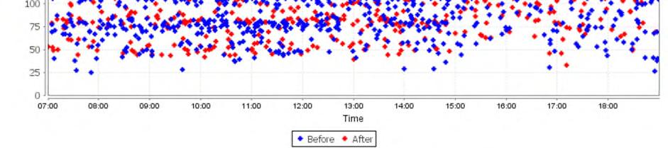
6 STRATAGIES Due to the volume of buses along the corridor the usual bus priority strategies that look at changing signal timings for each individual bus were not appropriate this led to new SPRUCE strategy being developed. This new strategy looks at the bus density on each approach to a junction and adjusts the stage green times accordingly. This strategy will help minimise attracting other traffic to the route by targeting the bonus green time to buses. Below the different strategies at each junction are briefly discussed: JUNCTION 1 WICKER / NURSERY STREET The inbound/outbound bus movements here are in different stages. The new SPRUCE strategy calculated bus density alters the inbound and outbound stage green times according to bus demand. The coordination between the junctions was also altered to try and favour buses, although with bus stops in both directions this gave limited benefits. The benefits from adding the strategy can be seen below, the travel time between the two junctions has been monitored and the majority of the blue BEFORE data is in a higher band showing it takes most buses two cycles of the traffic signals to clear the junction. The red AFTER data shows the majority of buses now in the lower band, with the slight compromise being the very lowest band that did have some BEFORE buses cannot now be used. This was achieved by the BEFORE buses chasing the greens and on balance the AFTER situation delivers safer signalling with an improved average journey time. 6

7 JUNCTION 2 WICKER / DEREK DOOLEY WAY (INNER RING ROAD) This junction suffered from buses frequently missing green due to insufficient green time. The bus route cuts across the Inner Ring Road so a fixed timing change was not possible, and it was important to not make the route attractive to other vehicles. Using the SPRUCE bus density to alter the inbound/outbound stage green time. It is able to make several small step changes in green time in response to bus density. The benefits from the strategy can clearly be seen below, the travel time between the two junctions has been monitored and the blue BEFORE data is on average higher than the red AFTER data, with the AFTER data having nearly eliminated the higher values over 100s. The slight banding shows the number of cycles the buses take to pass through the signals. JUNCTION 3 WICKER / SAVILLE STREET The inbound/outbound bus movements here are in different stages. The new SPRUCE strategy calculated bus density alters the inbound and outbound stage green times according to bus demand. The Saville Street (cross movement) green remains unaffected. The coordination between Saville Street and the Derek Dooley signals has been changed to favour the bus movements. 7
8 OVERALL RESULTS The overall journey time benefits are summarized below. These give the combined effect of each of the individual strategies that were discussed above. The total inbound benefits across the network strategy can be seen below. The blue BEFORE data is on average higher than the red AFTER data, with the AFTER data having nearly eliminated the higher values. This gives an inbound delay saving of 35s. The total outbound benefits across the network strategy can be seen below. The blue BEFORE data is on average higher than the red AFTER data, with the AFTER data having nearly eliminated the higher values. This gives an outbound delay saving of 16s and a total round trip average saving of 51s. 8
9 9
 in 1997.")
10 TRAMS, BUSES & TRAFFIC - MANOR TOP This network was written about in 2001 in the report UTMC01 Report 4: Laboratory Tests and Field Trials This report was the fourth and final scheduled report from the project UTMC01, Selected Vehicle Priority. The project was part of the research programme launched by the Department of the Environment Transport and the Regions (DETR) in The outcome of this project was running a tram priority strategy on Junctions 1 and 2 via the then prototype SPRUCE system. This ran for a few years until the prototype finally fell over and priority was no longer provided. In 2016 it was finally picked up by a scheme that allowed it to be revisited and the priority reinstated with the latest SPRUCE product along with adding a number of other benefits. The Manor Top network is situated at the intersection of Sheffield s Outer Ring Road with the City Road radial route from Sheffield. The network consists of a cluster of three main signalised junctions (numbered 1 to 3 below) separated by distances of 150 to 200 metres. Junctions 4 to 7 are also coordinated but their linking is less critical. The Tram tracks runs outbound from Sheffield through the network between Junction 1, 2 and 4 on the Outer Ring Road. Inbound tracks run in the reverse direction. On the approach to Manor Top, outbound trams run on-street with general traffic. Just before Junction 1, a segregated section of track starts. Junction 5 - Fairleigh Outer Ring Road Junction 6 - Fitzhubert Junction 7 - Queen Mary Node UTC linked Node Local linked Tram Stop Tram line Traffic queue adaptation Traffic compensation Junction 1 - Ridgeway / City Rd Junction 3 - Mansfield / Hurfield Tram Priority Junction 2 - Ridgeway / Hurfield Junction 4 Ridgeway Crescent 10
11 Since the demise of the 2002 SPRUCE prototype the outbound tram gets no priority at Junction 1 and suffers random delay. The conflicting Outer Ring Road is already over capacity. Aim 1 - To provide tram priority at junction 1 on the outbound approach to Manor Top During the PM peak there is queuing on the Outer Ring Road Southbound towards Junction 1. Aim 2 To monitor traffic congestion in the PM peak on the Outer Ring Road approach and make changes to avoid the build up of congestion. Junction 2 does have local LRT priority and when it runs there is an associated impact on traffic. This causes significant queuing back through junction 3 and beyond especially in the AM peak when it can block buses getting into their bus lane several hundred metres back from junction 3. Aim 3 - To reduce disruption caused by local LRT Tram priority by compensating other traffic STRATAGIES The SPRUCE strategies designed to target the issues outlined above have been described briefly below. AIM 1 - TRAM PRIORITY ON CITY ROAD The tram priority uses the historic journey time profile of trams on the Outbound approach to junction 1 to alter the timings at the Manor Top network to match the trams ETA. SPRUCE calculates the best way the network needs to be moved to match the ETA and then all junctions are slowly offset in anticipation of the trams arrival time. The upstream detection point is 1.5km away and gives around 2 ½ min travel time to prepare the network for its arrival. As the tram moves nearer it passes a number of detectors which the strategy uses to fine tune with increasing accuracy when a tram is due to arrive. Because this process is started early it minimizes disruption to traffic because small changes are spread over a number of cycles. When a tram is on the final approach it should arrive to correspond with the green window that allows it to pass through the junction without delay. Because the tram priority relies on consistent tram journey times, if any delays are being regularly incurred because of general traffic congestion in the shared lane (usually during the PM peak) then the priority is suspended until back to normal travel times. AIM 2 - TRAFFIC CONGESTION ON OUTER RING ROAD There was existing queue and flow detection on the Outer Ring Road approach to junction 1 (located at Junction 5). This was used to monitor traffic congestion queuing back from junction 1. In response to flow and queue condition the cycle time at the Manor Top junction (and surrounding network) is increased to improve the saturation flow and manage a queue build up. As the congestion level builds the cycle time incrementally increases, this can result in a maximum raise from 70s to 90s. 11
12 AIM 3 - COMPENSATION ON RIDGEWAY ROAD / HURFIELD ROAD At junction 2 tram priority has always been provided by local LRT style priority within the controllers. This priority was always effective at minimizing tram delay but due to the complexity of the network had never been able to compensate back to traffic. The base signal plan allows two windows for trams to call their priority stage, one window before the affected traffic stage and the other just after, this helps minimize tram delay but took all the time from one traffic stage which was also a bus route. Although there is a bus lane on the approach the queuing can often block buses getting into their bus lane. The SPRUCE strategy monitors which tram window is used and gives back a proportion of the time at the next opportunity. If the tram stage comes before the affected stage (takes green from the start) then when the traffic stage runs SPRUCE holds it on for a compensation period. If the tram stage comes just after the traffic stage (takes green from the end) then SPRUCE waits a full cycle until the stage next runs and adds the compensation to the normal green period. RESULTS AIM 1 RESULTS - TRAM PRIORITY The outbound tram delay on at Junction 1 was reduced by 65%. For the vast majority of trams this results in zero delay at the signals. The chart below shows the journey time from the tram detector on City Rd to the Exit detector just after the stopline. The chart shows blue BEFORE data is clearly higher than the red AFTER data. Tram journey time from detector on City Rd to the Exit detector 12
13 AIM 2 RESULTS TRAFFIC CONGESTION OUTER RING ROAD The total benefits across this network strategy are summarised below. The chart below shows the percent occupancy on the queue detector at Junction 5. Over 50% occupancy generally means traffic is queuing over the detector. The blue BEFORE data shows the occupancy rising in the PM peak to over 60% and remaining there until after 18:00. The red AFTER data shows a rise in the early peak to 40% but this is when the strategies respond and the queue is prevented from building up at all. To support the effects and having reduced the queuing on the approach to the junction, the traffic flow after the junction was also monitored. This gave an increase in average PM peak flow of a 25% increase. 70 Traffic Queuing Southbound Prince of Wales Rd at Fairleigh - % Occupancy of 1IWD1 60 % Occupancy /15min BEFORE AFTER :00 15:15 15:30 15:45 16:00 16:15 16:30 16:45 17:00 17:15 17:30 17:45 18:00 18:15 18:30 18:45 19:00 19:15 13
14 450 Traffic Flow Southbound at Chatsworth Park 1RAD2 Traffic Flow /15min BEFORE AFTER AIM 3 RESULTS TRAM COMPENSATION Since the junction 2 compensation strategy went live the traffic flows have increased up by about 10% in the AM peak. The results of this show that due to the improvements, there is less queuing and we are getting more vehicles through the junction in the hour. The following data has been collected from traffic counters (Monday Friday 5 day averages): From 07:00 08:00, flows have increased by around 30 vehicles From 08:00 09:00, flows have increased by around 55 vehicles 14
15 The following data was supplied by the bus operators and shows a saving of 107s during the AM peak. 15
WP3.4: Trial Area Case Studies
 Selected Vehicle Priority in the UTMC Environment (UTMC01)://www.its.leeds.ac.uk/projects/spruce/) WP3.4: Trial Area Case Studies Mervyn Hallworth, and Stuart Auty (Leeds City Council) Howard Saffer and
Improving the Bus Network through Traffic Signalling. Henry Axon Transport for London
 Improving the Bus Network through Traffic Signalling Henry Axon Transport for London Improving the Bus Network through Traffic Signalling Introduction Transport for London (TfL) operates the most frequent
RESPONSIVE ROUNDABOUTS MYTH OR REALITY
 RESPONSIVE ROUNDABOUTS MYTH OR REALITY Andy Poole WSP UK Three White Rose Office Park Millshaw Park Lane Leeds LS11 0DL andy.poole@wspgroup.com Keywords: Traffic signals, optimisation, micro-simulation,
Mathematics of Planet Earth Managing Traffic Flow On Urban Road Networks
 Mathematics of Planet Earth Managing Traffic Flow On Urban Road Networks Adrian George Manager Network Improvements Anthony Fitts Manager Signal Design Melbourne s transport demands are growing 5m people
SCOOT: Basic Principles
 SCOOT: Basic Principles Steve Holder Atkins Transportation Consultancy IHE Professional Certificate in Traffic Signal Control This presentation should assist you with the following competences; Competence
Bus priority in SCOOT
 Traffic Advisory Leaflet 8/00 December 2000 Bus priority in SCOOT Introduction This leaflet should be read in conjunction with TAL 7/99. It expands some of the information provided in the general guidance
SIDRA INTERSECTION 6.1 UPDATE HISTORY
 Akcelik & Associates Pty Ltd PO Box 1075G, Greythorn, Vic 3104 AUSTRALIA ABN 79 088 889 687 For all technical support, sales support and general enquiries: support.sidrasolutions.com SIDRA INTERSECTION
Transit Signal Preemption and Priority Treatments
 Transit Signal Preemption and Priority Treatments Peter Koonce, PE Portland, OR Today s Message Transit signal priority presents an opportunity to partner with an agency that isn t always recognized as
Self-Organizing Signals: A Better Framework for Transit Signal Priority
 Portland State University PDXScholar TREC Friday Seminar Series Transportation Research and Education Center (TREC) 3-13-2015 Self-Organizing Signals: A Better Framework for Transit Signal Priority Peter
Transit Signal Priority: Help or Hype? Peter G. Furth Northeastern University
 Transit Signal Priority: Help or Hype? Peter G. Furth Northeastern University Transit Signal Priority Help or Hype? Zurich: nearly zero traffic delay and impeccable punctuality for trams Portland, San
The SCOOT Urban Traffic Control System
 The SCOOT Urban Traffic Control System 1 Contents Introduction of SCOOT SCOOT System Architecture The SCOOT Traffic Model The SCOOT Signal Optimiser Several New Functions Discussion: Deficiencies of SCOOT
MILTON ROAD LLF PROJECT UPDATE
 Greater Cambridge City Deal MILTON ROAD LLF PROJECT UPDATE 9 th May 2017 Project objectives Comprehensive priority for buses in both directions wherever practicable; Additional capacity for sustainable
3 TRAFFIC CONTROL SIGNAL TIMING AND SYNCHRONIZATION
 Report No. 8 of the Transportation Services Committee Regional Council Meeting of October 20, 2011 3 TRAFFIC CONTROL SIGNAL TIMING AND SYNCHRONIZATION The Transportation Services Committee recommends:
Operational Comparison of Transit Signal Priority Strategies
 Operational Comparison of Transit Signal Priority Strategies Revision Submitted on: November, 0 Author: Adriana Rodriguez, E.I Assistant Engineer Parsons Brinckerhoff 0 South Orange Avenue, Suite 00 Orlando,
2.2 TRANSIT VISION 2040 FROM VISION TO ACTION. Emphasize transit priority solutions STRATEGIC DIRECTION
 TRANSIT VISION 2040 FROM VISION TO ACTION TRANSIT VISION 2040 defines a future in which public transit maximizes its contribution to quality of life with benefits that support a vibrant and equitable society,
Frascati Road and Temple Hill Route Improvements. Outline Design Report to Accompany Public consultation
 Frascati Road and Temple Hill Route Improvements Outline Design Report to Accompany Public consultation September 2013 Background: Dún Laoghaire-Rathdown is committed to providing high quality pedestrian
The Consultation has now ended.
 The Consultation has now ended. We have received Cabinet Member approval to undertake implementation of the Baker Street Two Way scheme. You are not viewing the most recent documentation. Please visit
Junction Design with Traffic Signals
 Junction Design with Traffic Signals Wednesday March 2 nd 2016 Overview Introduction Context Conventional Approach Sustainable Approach Analysis Design Summary Introduction What are Traffic Signals? Purpose
Data Driven Decisions for Centralised Bus Priority in Dublin City. Dublin City Council ITS Bus Priority James Calvey, Maggie O Donnell, Niall Bolger
 Data Driven Decisions for Centralised Bus Priority in Dublin City Traffic Signal Management in Dublin City Sydney Coordinated Adaptive Traffic System (SCATS) Adaptive system which reacts to traffic Over
TS 109 DURHAM ROAD QTC PHASE 4 PROJECT PROPOSAL. Page 1
 TS 109 DURHAM ROAD QTC PHASE 4 PROJECT PROPOSAL Page 1 Table of Contents 1.0 Introduction... 3 2.0 Project Overview... 3 3.0 Project Proposals... 4 3.1 Enfield Road / Durham Road Junction... 3 5 3.2 Summerfield
Regional Bus Priority
 Regional Bus Priority Recommendation(s) That the Board: i) Notes the systematic review for bus priority measures on the proposed Frequent Transit Network (FTN). Executive summary The New Network public
A65 TRANSPORT ASSESSMENT. 13 th May 2005
 A65 TRANSPORT ASSESSMENT 13 th May 2005 1 CONTENTS 1.0 Introduction 2.0 Overview 3.0 Detailed Assessment of the A65 Corridor 4.0 Future Proposals 5.0 Conclusions List of Figures Figure 1: AM Average Traffic
Transit Priority. Peter G Furth
 Transit Priority Peter G Furth Fourth in a series of Policy Briefings to Boston City Council s Committee on Parks, Recreation, & Transportation Feb 2, 2017 What Does Transit Priority Look Like? Zurich
Municipality of Sofia Traffic Master Plan. Intelligent Transport Systems Strategy Andrew Walsh
 Municipality of Sofia Traffic Master Plan Intelligent Transport Systems Strategy Andrew Walsh Introduction Presentation to describe an ITS Strategy for Sofia developed as part of the Sofia Traffic Master
DYNAMIC LANES FOR AUCKLAND
 Dynamic Lanes for Auckland MENEZES M. and INMAN R. Page 1 DYNAMIC LANES FOR AUCKLAND Authors: INMAN, Robert BA (Hons) Previously Auckland Transport Senior Traffic Engineer Now Aurecon Robert.Inman@aurecongroup.com
ONE SIZE DOESN T FIT ALL RECONCILING OVERLAPPING TRANSPORT NETWORKS IN A CONSTRAINED URBAN ENVIRONMENT
 One Size Doesn t Fit All S Corbett, C Chenery Page 1 ONE SIZE DOESN T FIT ALL RECONCILING OVERLAPPING TRANSPORT NETWORKS IN A CONSTRAINED URBAN ENVIRONMENT Authors/Presenters: Sam Corbett, Principal Transport
ENHANCED PARKWAY STUDY: PHASE 2 CONTINUOUS FLOW INTERSECTIONS. Final Report
 Preparedby: ENHANCED PARKWAY STUDY: PHASE 2 CONTINUOUS FLOW INTERSECTIONS Final Report Prepared for Maricopa County Department of Transportation Prepared by TABLE OF CONTENTS Page EXECUTIVE SUMMARY ES-1
Nottingham Cycle City Frequently Asked Questions
 Nottingham Cycle City Frequently Asked Questions About the scheme How much money is to be spent on cycling? And where is the money from? We have 6.1 million in Growth Fund which we will be investing directly
DESIGN CONSIDERATIONS FOR BUS PRIORITY ABSTRACT
 DESIGN CONSIDERATIONS FOR BUS PRIORITY J COETZEE and G WESSELS ITS Engineers (Pty) Ltd E-Mail: jan@itse.co.za ; gerrit@itse.co.za ABSTRACT Providing priority to buses at traffic signals is widely used
MILTON ROAD ~ MITCHAM'S CORNER PARAMICS MODEL INITIAL OPTION TESTING
 MILTON ROAD ~ MITCHAM'S CORNER PARAMICS MODEL INITIAL OPTION TESTING NOVEMBER 216 MILTON ROAD ~ MITCHAM'S CORNER PARAMICS MODEL INITIAL OPTION TESTING Cambridgeshire County Council Type of document (version)
Update June 2018 OUR 2017 PUBLIC ENGAGEMENT
 Update June 2018 Hi, Let s Get Wellington Moving (LGWM) is developing a Recommended Programme of Investment (RPI) that meets our programme objectives and supports the city s and region s growth. As part
M-58 HIGHWAY ACCESS MANAGEMENT STUDY Mullen Road to Bel-Ray Boulevard. Prepared for CITY OF BELTON. May 2016
 M-58 HIGHWAY ACCESS MANAGEMENT STUDY Prepared for CITY OF BELTON By May 2016 Introduction Missouri State Highway 58 (M-58 Highway) is a major commercial corridor in the City of Belton. As development has
Marcus Jones, TRL. Presented by Name Here Job Title - Date
 Segregation Insert the title and of priority your at presentation junctions: a here discussion Marcus Jones, TRL Presented by Name Here Job Title - Date Background: TfL cycle facility trials Infrastructure
1 This technical note considers the issues associated with the use of tidal flow bus lanes on key public transport corridors in Cambridge.
 TECHNICAL NOTE: TIDAL FLOW BUS LANE OPTION ASSESSMENT Purpose 1 This technical note considers the issues associated with the use of tidal flow bus lanes on key public transport corridors in Cambridge.
M6 Junction 10 Public Consultation
 M6 Junction 10 Public Consultation December 2015 Introduction Walsall Council and Highways England are developing plans to provide a long term improvement to M6 junction 10. We are holding this non-statutory
Simulation Analysis of Intersection Treatments for Cycle Tracks
 Abstract Simulation Analysis of Intersection Treatments for Cycle Tracks The increased use of cycle tracks also known as protected bike lanes has led to investigations of how to accommodate them at intersections.
Technical note. 1. Introduction
 Project: A428 study - Phase 2 To: Adrian Shepherd Subject: Park & Ride site locations From: Atkins Date: Jun 3, 2016 cc: Ashley Heller 1. Introduction 1.1. Purpose of Technical Note The purpose of this
March Maidstone Integrated Transport Strategy Boxley Parish Council Briefing Note. Context. Author: Parish Clerk 2 March 2016
 Context. Author: Parish Clerk 2 The Draft Integrated Transport Policy (DITS) sets out a vision and objectives, and identifies a detailed programme of interventions to support the Maidstone Borough Local
Some interesting questions of traffic signal control
 Some interesting questions of traffic signal control HELMI and Public Transport Priority functions (skipped, discussed already on lectures) Joker signals Low cost traffic controil in the city of Helsinki
Self-Organizing Traffic Signals Using Secondary Extension and Dynamic Coordination Rules
 Self-Organizing Traffic Signals Using Secondary Extension and Dynamic Coordination Rules Burak Cesme (corresponding author) Department of Civil and Environmental Engineering Northeastern
Mill Hill Broadway Capacity Improvement
 1 16 MARCH 2016 Mill Hill Broadway Capacity Improvement Presentation to Barnet Members and Mill Hill Residents Association 2 Background A1 is one of 23 Transport for London Road Network (TLRN) Strategic
Multimodal Approach to Planning & Implementation of Transit Signal Priority within Montgomery County Maryland
 Multimodal Approach to Planning & Implementation of Transit Signal Priority within Montgomery County Maryland A Path to Successful Implementation James Allday Bunch - Sabra, Wang & Associates, Inc. ITS
Bristol City Council has produced a draft Bristol Transport Strategy document.
 Bristol Transport Strategy Summary Document Introduction Bristol City Council has produced a draft Bristol Transport Strategy document. The Strategy fills a gap in transport policy for Bristol. We have
Module 3 Developing Timing Plans for Efficient Intersection Operations During Moderate Traffic Volume Conditions
 Module 3 Developing Timing Plans for Efficient Intersection Operations During Moderate Traffic Volume Conditions CONTENTS (MODULE 3) Introduction...1 Purpose...1 Goals and Learning Outcomes...1 Organization
Impacts of Bus Priority in Coordinated Traffic Signals
 Available online at www.sciencedirect.com Procedia Social and Behavioral Sciences 16 (2011) 578 587 6 th International Symposium on Highway Capacity and Quality of Service Stockholm, Sweden June 28 July
Motorway-to-motorway: a potential technological solution to motorway congestion
 108 Roger Higginson Principal Engineer Intelligent Transport Systems Atkins Jill Hayden Principal Engineer Intelligent Transport Systems Atkins Sukhvinder Ubhi Project Sponsor Highways Agency Motorway-to-motorway:
PIG MOTION AND DYNAMICS IN COMPLEX GAS NETWORKS. Dr Aidan O Donoghue, Pipeline Research Limited, Glasgow
 PIG MOTION AND DYNAMICS IN COMPLEX GAS NETWORKS Dr Aidan O Donoghue, Pipeline Research Limited, Glasgow A model to examine pigging and inspection of gas networks with multiple pipelines, connections and
Traffic Engineering and Operations for BRT in Los Angeles
 Traffic Engineering and Operations for BRT in Los Angeles NACTO BRT Running Way Workshop #2 June 29, 2010 By: Kang Hu, PE, PTOE Chun Wong, PE LADOT s s Involvement in BRT LADOT has partnered with LA Metro
Signal Priority near Major Bus Terminal
 Signal Priority near Major Bus Terminal Case Study of Station, Boston, Massachusetts Peter G. Furth, Burak Cesme, and Tarannum Rima Near major bus terminals, multiple bus arrivals per signal cycle and
Integrated Regional Traffic Management. Michael Aherne Technical Director POLIS Conference 2009
 Integrated Regional Traffic Management Michael Aherne Technical Director POLIS Conference 2009 M50 finish Public Transport and Pedestrians College Green The Spatial Perspective What Could has
TRANSIT SIGNAL PRIORITY The Toronto Experience
 TRANSIT SIGNAL PRIORITY The Toronto Experience July 27, 2004 July 27, 2004 1 Warning This presentation contains graphic images depicting serious violations to the coordination of traffic signals and may
ROUNDABOUT CAPACITY: THE UK EMPIRICAL METHODOLOGY
 ROUNDABOUT CAPACITY: THE UK EMPIRICAL METHODOLOGY 1 Introduction Roundabouts have been used as an effective means of traffic control for many years. This article is intended to outline the substantial
Transport Workshop Dearbhla Lawson Head of Transport & Infrastructure Policy & Funding University of the Third Age.
 Transport Workshop Dearbhla Lawson Head of Transport & Infrastructure Policy & Funding University of the Third Age 30 th March 2015 1 Presentation Overview Roles and responsibilities Snapshot of Key Challenges
How to achieve fluid traffic
 Kanton Basel-Stadt How to achieve fluid traffic Objectives, instruments and limits of traffic management Alain Groff, Office for Mobility, Canton of Basel-Stadt Overview Some figures about Basel Tools
HIGHBURY AVENUE/HAMILTON ROAD INTERSECTION IMPROVEMENTS PUBLIC INFORMATION CENTRE 1 MAY 14, 2015
 HIGHBURY AVENUE/HAMILTON ROAD INTERSECTION IMPROVEMENTS Municipal Class Environmental Assessment PUBLIC INFORMATION CENTRE 1 MAY 14, 2015 ACCESSIBILITY Under the Accessibility Standards 2015 for Customer
TRAFFIC IMPACT STUDY CRITERIA
 Chapter 6 - TRAFFIC IMPACT STUDY CRITERIA 6.1 GENERAL PROVISIONS 6.1.1. Purpose: The purpose of this document is to outline a standard format for preparing a traffic impact study in the City of Steamboat
Enforcement of Bus Lane and Moving Traffic Contraventions in Cardiff. Councillor Briefing Pack
 Enforcement of Bus Lane and Moving Traffic Contraventions in Cardiff Councillor Briefing Pack Enforcement of Moving Traffic Contraventions Basic Legislation Applying since 2004: The Traffic Management
CAMBOURNE TO CAMBRIDGE BETTER PUBLIC TRANSPORT PROJECT PHASE 2 PUBLIC CONSULTATION MADINGLEY MULCH ROUNDABOUT TO CAMBOURNE
 CAMBOURNE TO CAMBRIDGE BETTER PUBLIC TRANSPORT PROJECT PHASE 2 PUBLIC CONSULTATION MADINGLEY MULCH ROUNDABOUT TO CAMBOURNE Have your say on proposals for a new public transport link and Park & Ride facility
Design and Evaluation of Adaptive Traffic Control System for Heterogeneous flow conditions
 Design and Evaluation of Adaptive Traffic Control System for Heterogeneous flow conditions Tom Mathew IIT Bombay Outline 1. Heterogeneous traffic 2. Traffic Simulation 3. Traffic Signal control 4. Adaptive
Corporate. Report COUNCIL DATE: June 26, 2006 NO: C012 COUNCIL-IN-COMMITTEE. TO: Mayor & Council DATE: June 22, 2006
 Corporate NO: C012 Report COUNCIL DATE: June 26, 2006 COUNCIL-IN-COMMITTEE TO: Mayor & Council DATE: June 22, 2006 FROM: General Manager, Engineering FILE: 0410-20(MoT/Gate) SUBJECT: Surrey Response on
A New Lane-Based Model for Platoon Patterns at Closely-Spaced Signalised Intersections
 Akcelik & Associates Pty Ltd PO Box 1075G, Greythorn, Vic 3104 AUSTRALIA info@sidrasolutions.com Management Systems Registered to ISO 9001 ABN 79 088 889 687 REPRINT A New Lane-Based Model for Platoon
TRAFFIC MANAGEMENT PLAN
 April 19, 018 PK# 415-17.387 TRAFFIC MANAGEMENT PLAN Project: In Dallas, Texas Prepared for: City of Dallas On behalf of: Dallas Independent School District Prepared by: Hunter W. Lemley, P.E. 7557 Rambler
Operational Performance Comparison between Three Unconventional Intersection Designs: Left-turn Bypass, Diverging Flow and Displaced Left-turn
 Ninth LACCEI Latin American and Caribbean Conference (LACCEI 2011), Engineering for a Smart Planet, Innovation, Information Technology and Computational Tools for Sustainable Development, August 3-5, 2011,
20mph. We want to make Edinburgh a better and safer place to live, work and play.
 20mph CREATING A BETTER SAFER EDINBURGH We want to make Edinburgh a better and safer place to live, work and play. That s why on 13 January 2015 Councillors approved a new speed limit network for Edinburgh
9. Parking Supporting Statement
 9. Parking Supporting Statement Content 1. Setting the Scene 2. Vision 3. Parking and the Shared Priorities 4. Issues 5. Delivery Programme in the first Plan Period 2001/02 2005/06 6. Good Practice 7.
Comments on the Hailsham to Eastbourne Sustainable Transport Corridor
 Comments on the Hailsham to Eastbourne Sustainable Transport Corridor Version 1.1 25/01/2015 Paul Humphreys 1 Table of Contents Version Control... 2 Summary... 2 Rationale provided by ESCC... 3 The ESCC
Bus Riders of Saskatoon Meeting with City of Saskatoon Utility Services Department October 23, :30pm 2:30pm th Street West, Saskatoon
 Bus Riders of Saskatoon Meeting with City of Saskatoon Utility Services Department October 23, 2014 1:30pm 2:30pm 301 24 th Street West, Saskatoon Bus Riders of Saskatoon Members: Marianne, Chief and Sarina
In station areas, new pedestrian links can increase network connectivity and provide direct access to stations.
 The Last Mile Planning for Pedestrians Planning around stations will put pedestrians first. Making walking to stations safe and easy is important; walking will be a part of every rapid transit Accessible
Public Consultation on Braintree Integrated Transport Package (ITP) HAVE YOUR. Consultation open from 24 September to 5 November 2018 SAY
 HAVE YOUR. Consultation open from 24 September to 5 November 2018 SAY") Public Consultation on Braintree Integrated Transport Package (ITP) HAVE YOUR SAY Consultation open from 24 September to 5 November 2018 Contents Introduction 3 Background 4 Springwood Drive Roundabout
Public Consultation on Braintree Integrated Transport Package (ITP) HAVE YOUR SAY Consultation open from 24 September to 5 November 2018 Contents Introduction 3 Background 4 Springwood Drive Roundabout
Introduction to Roundabout Analysis Using ARCADY
 Introduction to Roundabout Analysis Using ARCADY Toronto SimCap User Group Technical Event and ITE Toronto Section Social Event July 22, 2014 Phil Weber, P.Eng. GHD Inc. (The Home of Ourston Roundabout
Determining bicycle infrastructure preferences A case study of Dublin
 *Manuscript Click here to view linked References 1 Determining bicycle infrastructure preferences A case study of Dublin Brian Caulfield 1, Elaine Brick 2, Orla Thérèse McCarthy 1 1 Department of Civil,
METHODOLOGY. Signalized Intersection Average Control Delay (sec/veh)
") Chapter 5 Traffic Analysis 5.1 SUMMARY US /West 6 th Street assumes a unique role in the Lawrence Douglas County transportation system. This principal arterial street currently conveys commuter traffic
Chapter 5 Traffic Analysis 5.1 SUMMARY US /West 6 th Street assumes a unique role in the Lawrence Douglas County transportation system. This principal arterial street currently conveys commuter traffic
Canada s Capital Region Delegation to the Velo-City Global 2010 Conference
 Canada s Capital Region Delegation to the Velo-City Global 2010 Conference Report of Findings from Visits, Meetings & Presentations In Amsterdam-Den Haag, Utrecht, Berlin & Copenhagen The Itinerary Copenhagen
Map 1 shows the two roads, and how they fit into the public transport network in and around Cambridge.
 Milton Road and Histon Road corridors bus priority infrastructure 1. Purpose The County Council would like to understand in more detail, the options to deliver the most effective corridor-based public
Design and Evaluation of Adaptive Traffic Control System for Heterogeneous flow conditions. SiMTraM & CosCiCost2G
 Design and Evaluation of Adaptive Traffic Control System for Heterogeneous flow conditions SiMTraM & CosCiCost2G Tom Mathew IIT Bombay Outline 1. Heterogeneous traffic 2. Traffic Simulation 3. Traffic
At each type of conflict location, the risk is affected by certain parameters:
 TN001 April 2016 The separated cycleway options tool (SCOT) was developed to partially address some of the gaps identified in Stage 1 of the Cycling Network Guidance project relating to separated cycleways.
Making Signals Work for Bicyclists and Pedestrians
 Making Signals Work for Bicyclists and Pedestrians Peter Koonce, PE Portland, OR October 18, 2017 PBIC Webinar pedbikeinfo.org @pedbikeinfo Housekeeping Problems with audio? Dial into the phone line instead
VIVA RETIREMENT COMMUNITIES OAKVILLE TRAFFIC IMPACT STUDY
 VIVA RETIREMENT COMMUNITIES OAKVILLE TRAFFIC IMPACT STUDY VIVA RETIREMENT COMMUNITIES OAKVILLE TRAFFIC IMPACT STUDY DECEMBER 2012 READ, VOORHEES & ASSOCIATES TORONTO, ONTARIO Read, Voorhees & Associates
Amendments to Essex Highway Maintenance Strategy Maintenance Policy and Standards April 2008
 Amendments to Essex Highway Maintenance Strategy Maintenance Policy and Standards April 2008 The following amendments to the wording of the maintenance strategy apply following the revised maintenance
Welcome. If you have any questions or comments on the project, please contact:
 Welcome This drop-in public open house is intended to provide information about the Bay Street bike lanes project. This project proposes a dedicated cycling facility along Bay Street between Aberdeen Avenue
Simulating Street-Running LRT Terminus Station Options in Dense Urban Environments Shaumik Pal, Rajat Parashar and Michael Meyer
 Simulating Street-Running LRT Terminus Station Options in Dense Urban Environments Shaumik Pal, Rajat Parashar and Michael Meyer Abstract The Exposition Corridor transit project is a light rail project
MARKHOUSE ROAD IMPROVEMENTS
 MARKHOUSE ROAD IMPROVEMENTS www.enjoywalthamforest.co.uk Waltham Forest is changing and we want you to be part of it. Thanks to a funding pot of 27million from Transport for London, we re delivering the
4 DISRUPTION MANAGEMENT PLAN HIGHWAY 7 RAPIDWAY CONSTRUCTION BETWEEN BAYVIEW AVENUE AND WARDEN AVENUE TOWNS OF MARKHAM AND RICHMOND HILL
 4 DISRUPTION MANAGEMENT PLAN HIGHWAY 7 RAPIDWAY CONSTRUCTION BETWEEN BAYVIEW AVENUE AND WARDEN AVENUE TOWNS OF MARKHAM AND RICHMOND HILL The Transportation Services Committee recommends the adoption of
Greater Cambridge City Deal Executive Board & Joint Assembly
 Greater Cambridge City Deal Executive Board & Joint Assembly Welcome to the Call for Evidence on tackling congestion in Cambridge Launch Event 11 th November 2015 Bob Menzies Service Director: Strategy
HISTON ROAD Have your say on better public transport, cycling and walking journeys
 HISTON ROAD Have your say on better public transport, cycling and walking journeys Have your say: Please complete the survey inside this leaflet or online at www.greatercambridge.org.uk/histonconsultation
CAMBRIDGE SOUTH WEST PARK & RIDE
 CAMBRIDGE SOUTH WEST PARK & RIDE Have your say on: Extra Park & Ride spaces to the south west of Cambridge Bus priority measures into the city centre CREATING MORE PARK & RIDE SPACES The existing Park
Global Journal of Engineering Science and Research Management
 SIMULATION AND OPTIMZING TRAFFIC FLOW AT SIGNALIZED INTERSECTION USING MATLAB Dr Mohammed B. Abduljabbar*, Dr Amal Ali, Ruaa Hameed * Assist Prof., Civil Engineering Department, Al-Mustansiriayah University,
HENDERSON DEVELOPMENT 213, 217, 221, 221 ½, 223 HENDERSON AVENUE and 65 TEMPLETON STREET OTTAWA, ONTARIO TRANSPORTATION OVERVIEW.
 HENDERSON DEVELOPMENT 213, 217, 221, 221 ½, 223 HENDERSON AVENUE and 65 TEMPLETON STREET OTTAWA, ONTARIO TRANSPORTATION OVERVIEW Prepared for: 2294170 Ontario Inc. February 2, 2017 117-652 Report_1.doc
TRAFFIC MANAGEMENT PLAN
 May 4, 018 PK# 415-17.387 Z 178-150 TRAFFIC MANAGEMENT PLAN Project: In Dallas, Texas Prepared for: City of Dallas On behalf of: Dallas Independent School District Prepared by: Hunter W. Lemley, P.E. 7557
Report from Embassy Visit to Copenhagen May David Arditti
 Report from Embassy Visit to Copenhagen May 2013 David Arditti Standard CPH cycle track, one-way 1.5 2m wide, 5cm above carriageway, 5cm below footway Basic one-way cycle track protected by car parking
CONNECTED VEHICLE PILOT DEPLOYMENT PROGRAM
 CONNECTED VEHICLE PILOT DEPLOYMENT PROGRAM August 2, 2016 Presentation Concept Pilot Location Deployment Characteristics Use Cases Application Overview 2 Concept Demonstrate and measure the impact of Connected
Scheduling 101 Calculating Running Time Metropolitan Atlanta Rapid Transit Authority Multimodal Operations Workshop Houston, TX
 Calculating Running Time Metropolitan Atlanta Rapid Transit Authority 2015 Multimodal Operations Workshop Houston, TX MARTA FACTS MARTA is the ninth largest transit system in the U.S. that provides bus
DON MILLS-SHEPPARD Mobility Hub Profile
 DON MILLS-SHEPPARD Mobility Hub Profile Dundas Don Mills-Sheppard West-Bloor Anchor Hub Gateway Hub N MOBILITY HUBS: Places of connectivity between regional and rapid transit services, where different
LOOP 360 IMPROVEMENT STUDY
 LOOP 360 IMPROVEMENT STUDY Overview and Preliminary Analysis August 2015 1 STUDY PROCESS 2 Study Background Loop 360 serves a wide range of users, including residents, businesses, bicyclists, and commuters
Frome Street Bicycle Route
 The Adelaide City Council invites engagement from the community about Frome Street Bicycle Route Project Summary Adelaide City Council is seeking feedback on design options to construct bicycle facilities
Appendix A-K Public Information Centre 2 Materials
 Appendix A-K Public Information Centre 2 Materials Our Rapid Transit Initiative Make an impact on the future of transit Join the discussion on Rapid Transit in London You re invited to a Public Information
Roadways. Roadways III.
 Introduction 97 Roadway Design Principles 98 Safe Speeds 99 Optimizing of Street Space 00 Minimum Lane Widths in the City of Boston 02 Design Features that Reduce Operating Speeds 05 Travel Lanes Transit
CHAPTER 2G. PREFERENTIAL AND MANAGED LANE SIGNS
 2011 Edition - Revision 2 Page 275 Section 2G.01 Scope CHAPTER 2G. PREFERENTIAL AND MANAGED LANE SIGNS 01 Preferential lanes are lanes designated for special traffic uses such as high-occupancy vehicles
Multi-criteria Evaluation of Traffic Signal Control Manfred Boltze and Wei Jiang 1
 Multi-criteria Evaluation of Traffic Signal Control Manfred Boltze and Wei Jiang Transport Planning and Traffic Engineering, Technische Universität Darmstadt Future City 2017: Urban Sustainable Development
EXECUTIVE SUMMARY Callan Park accommodates travel from a wide range of transport modes, including walking, cycling, bus and light rail.
 TRANSPORT AND ACCESS EXECUTIVE SUMMARY Callan Park accommodates travel from a wide range of transport modes, including walking, cycling, bus and light rail. Whilst there are some walking facilities within