Centralised Bus Priority System Dublin Public Transport Interface Module (DPTIM)
|
|
|
- Daniella Watkins
- 5 years ago
- Views:
Transcription


1 Centralised Bus Priority System Dublin Public Transport Interface Module (DPTIM)
2 Background Dublin Public Transport Interface Module. Building on existing SCATS infrastructure. Centralised system - No extra onsite equipment necessary. Virtual Detector configuration. No extensive civil works required. No additional cost to quantify performance of bus services for other projects. Allows for network bus priority multiple traffic junctions. Project consists of DPTIM Interventions, Signal Optimisation and Light Civil Work. Screen shot from DPTIM interface


3 System Architecture Real time XML data feed Centralised Bus Priority System Data Analysis Virtual Detector Placement Tableau MS-SQL Reports Dublin Bus Data

4

5 Display all buses currently on a route that services bus stop 315 Bachelors Walk

6 Each bus position bring the following information; Route information < 16> At a stop and stop details < 1354> Schedule deviation: <-10> In Congestion : <False>
7 Reporting Bus positions


8 Reporting Bus positions


9 QBC Performance Reports Bus Performance Report Segments of a Quality Bus Corridor Drill into segments using bus position data reveals pinch points
 00837 168 137 123 57 138 9587 16:00-19:00 2 Parnell Square Rotunda Hospital (+) 00007 62 143 43 87")
 02001 50 76 66 68 73 3385 16:00-19:00 5 Dorset St Eccles Place (+) 00014 45 139 32 72 52 3235 16:00-19:00 6 Mckee Avenue Finglas Village (-) 04938 28 69 41 88-52 2463 16:00-19:00 7")
10 Unscheduled Stops Report Bus Performance Report Unscheduled Stops Report Ranking on frequency to delays on approach to bus stop Time band Rank Stop Name Stop No. Stops Trips % Average Stop time Average Impact Distance 16:00-19:00 1 Whitworth Road David Road (+) :00-19:00 2 Parnell Square Rotunda Hospital (+) :00-19:00 3 Westmoreland Street Fleet Street (+) :00-19:00 4 High Street St. Auden's Church (+) :00-19:00 5 Dorset St Eccles Place (+) :00-19:00 6 Mckee Avenue Finglas Village (-) :00-19:00 7 Cardiffsbridge Rd Cappagh Road (+) :00-19:00 8 O'Connell St Henry Street (+) Mapping the bus position on approach to the Bus Stop data reveals pinch points
11 Bus Lane ends due to Road Capacity Location of Delays Green Before Stop Purple After Stop
12 Bus Lane ends due to Road Capacity Location of Delays Green Before Stop Purple After Stop

13 Bus Lane ends due to Road Capacity
14 Bus Lane ends due to Road Capacity Use DPTIM Virtual Detector(s)


15 Bus Lane ends due to Road Capacity Use DPTIM Virtual Detector(s)
16 Camden Street Delays due to lack of road capacity Location of Delays Green Before Stop Purple After Stop
17 Camden Street Delays due to lack of road capacity Location of Delays Green Before Stop Purple After Stop
18 Camden Street Delays due to lack of road capacity Location of Delays Green Before Stop Purple After Stop
19

20
21


22 January January


23 2016 January 2017 January


24 Virtual Detector


25 Virtual Detector in operation

26 Results Virtual Detector in Operation


27 Results - Blanchardstown

28 Clondalkin QBC 14 DPTIM detectors. 6 junctions added to SCATS. 1 junction personality change. Signing and lining.

29 Results - Clondalkin QBC
30 Results - Clondalkin QBC

31 Results - Clondalkin QBC

32 Whithworth Rd Review

33 Whithworth Rd - Review


34 Lining and other civil work


35 Clarehall/Malahide Rd Inbound bus stuck in traffic during AM/PM Limits the possibility of assisting inbound buses in PM via DPTIM intervention.


36 Clarehall/Malahide Rd Lane reassignment allows extension of bus lane and reduction in delays during peaks.

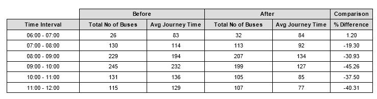
37 Results - Clarehall

38 Results - Clarehall
39 Swords Road Before installing Bollards to protect Bus Lane

40 Swords Road Before installing Bollards to protect Bus Lane


41 Swords Road Installing Bollards to protect Bus Lane
42 Swords Road After installing Bollards to protect Bus Lane

43 Swords Road After installing Bollards to protect Bus Lane
44 Swords Road After installing Bollards Reports From Dublin Bus
45 Conclusion Opportunity for Complete Corridor Analysis. Bus Performance quantifiable via the Bus position data/reports. Complements existing methods: Light civil works Traffic signal optimisation Amendments are configurable. Highly effective, low cost method. How the City is Performing.
46 Conclusion Opportunity for Complete Corridor Analysis. Bus Performance quantifiable via the Bus position data/reports. Complements existing methods: Light civil works Traffic signal optimisation Amendments are configurable. Highly effective, low cost method.
47 Conclusion Opportunity for Complete Corridor Analysis. Bus Performance quantifiable via the Bus position data/reports. Complements existing methods: Light civil works Traffic signal optimisation Amendments are configurable. Highly effective, low cost method.
48 Conclusion Opportunity for Complete Corridor Analysis. Bus Performance quantifiable via the Bus position data/reports. Complements existing methods: Light civil works Traffic signal optimisation Amendments are configurable. Highly effective, low cost method.


49 Conclusion Opportunity for Complete Corridor Analysis. Bus Performance quantifiable via the Bus position data/reports. Complements existing methods: Light civil works Traffic signal optimisation Amendments are configurable. Highly effective, low cost method.
Data Driven Decisions for Centralised Bus Priority in Dublin City. Dublin City Council ITS Bus Priority James Calvey, Maggie O Donnell, Niall Bolger
 Data Driven Decisions for Centralised Bus Priority in Dublin City Traffic Signal Management in Dublin City Sydney Coordinated Adaptive Traffic System (SCATS) Adaptive system which reacts to traffic Over
The Consultation has now ended.
 The Consultation has now ended. We have received Cabinet Member approval to undertake implementation of the Baker Street Two Way scheme. You are not viewing the most recent documentation. Please visit
SPRUCING UP YOUR ITS. Sheffield City Council - August Brent Collier Stephanie Cooper Ben Hallworth
 SPRUCING UP YOUR ITS Sheffield City Council - August 2017 Brent Collier Stephanie Cooper Ben Hallworth 1 CONTENTS SPRUCING UP YOUR ITS... 1 Introduction... 3 SPRUCE Background... 3 Architecture... 4 Strategies...
Chelmsford City Growth Package
 Chelmsford City Growth Package Public Consultation Document Volume 2 West Chelmsford July - August 2017 Chelmsford City Growth Package Public Consultation Document - Volume 2 - West Chelmsford Contents
Developing a Birmingham Transport Space Allocation policy. David Harris Transport Policy Manager Economy Directorate Birmingham City Council
 Developing a Birmingham Transport Space Allocation policy David Harris Transport Policy Manager Economy Directorate Birmingham City Council Birmingham s Sustainable Urban Mobility Plan Birmingham Connected
Public Works and Infrastructure Committee. General Manager, Transportation Services
 STAFF REPORT ACTION REQUIRED Extending the Bay Street Bicycle Lanes Date: May 16, 2013 To: From: Public Works and Infrastructure Committee General Manager, Transportation Services Wards: Toronto Centre
Regional Bus Priority
 Regional Bus Priority Recommendation(s) That the Board: i) Notes the systematic review for bus priority measures on the proposed Frequent Transit Network (FTN). Executive summary The New Network public
PROJECT FACT SHEET March 21, 2018
 SITE CHALLENGES & PROJECT BACKGROUND In 2014, the City of Aspen identified the Castle Creek Bridge and Hallam Street corridor as a deficient link in Aspen s bicycle and pedestrian network. Safe and efficient
Technical note. 1. Introduction
 Project: A428 study - Phase 2 To: Adrian Shepherd Subject: Park & Ride site locations From: Atkins Date: Jun 3, 2016 cc: Ashley Heller 1. Introduction 1.1. Purpose of Technical Note The purpose of this
Map 1 shows the two roads, and how they fit into the public transport network in and around Cambridge.
 Milton Road and Histon Road corridors bus priority infrastructure 1. Purpose The County Council would like to understand in more detail, the options to deliver the most effective corridor-based public
BURGAS INTEGRATED PUBLIC TRANSPORT PROJECT. Information day, 5 th July 2011, Burgas
 BURGAS INTEGRATED PUBLIC TRANSPORT PROJECT Information day, 5 th July 2011, Burgas BRT TECHNICAL DESIGN TENDER Preliminary tender specifications and requirements Overview 1 Burgas BRT concept 2 Main outputs
Mill Hill Broadway Capacity Improvement
 1 16 MARCH 2016 Mill Hill Broadway Capacity Improvement Presentation to Barnet Members and Mill Hill Residents Association 2 Background A1 is one of 23 Transport for London Road Network (TLRN) Strategic
BUS RAPID TRANSIT. A Canadian Perspective. McCormick Rankin International. John Bonsall P.Eng
 BUS RAPID TRANSIT A Canadian Perspective Why choose BRT? Because it is a practical and cost effective rapid transit solution for the most common types of land use in urban Canada Operating experience shows
PROJECT FACT SHEET May 25, 2018
 SITE CHALLENGES & PROJECT BACKGROUND In 2014, the City of Aspen identified the Castle Creek Bridge and Hallam Street corridor as a deficient link in Aspen s bicycle and pedestrian network. Safe and efficient
In station areas, new pedestrian links can increase network connectivity and provide direct access to stations.
 The Last Mile Planning for Pedestrians Planning around stations will put pedestrians first. Making walking to stations safe and easy is important; walking will be a part of every rapid transit Accessible
Improving the Bus Network through Traffic Signalling. Henry Axon Transport for London
 Improving the Bus Network through Traffic Signalling Henry Axon Transport for London Improving the Bus Network through Traffic Signalling Introduction Transport for London (TfL) operates the most frequent
TRAFFIC IMPACT ANALYSIS
 TRAFFIC IMPACT ANALYSIS FOR THE CHAMPAIGN UNIT#4 SCHOOL DISTRICT PROPOSED HIGH SCHOOL (SPALDING PARK SITE) IN THE CITY OF CHAMPAIGN Final Report Champaign Urbana Urbanized Area Transportation Study 6/24/2014
South King County High-Capacity Transit Corridor Study
 HIGH-CAPACITY TRANSIT CORRIDOR STUDY South King County Corridor South King County High-Capacity Transit Corridor Study Corridor Report August 2014 South King County High Capacity Transit Corridor Report
Eliminate on-street parking where it will allow for a dedicated bus only lane %
 Traffic Dashboard Priorities Survey Responses Introduction 1) Are you familiar with bus rapid transit (BRT)? a. No, BRT is new to me. 597 23.5% b. I ve heard of BRT, but I don t know much about it. 1,136
Integrated Regional Traffic Management. Michael Aherne Technical Director POLIS Conference 2009
 Integrated Regional Traffic Management Michael Aherne Technical Director POLIS Conference 2009 M50 finish Public Transport and Pedestrians College Green The Spatial Perspective What Could has
5 Baseline Traffic Conditions (2006/ 2007)
") 5.1 Introduction 5.1.1 The Metro North scheme is approximately 18 kilometres in length and therefore for clarity the current traffic conditions are described on an area by area basis as well from a strategic
5.1 Introduction 5.1.1 The Metro North scheme is approximately 18 kilometres in length and therefore for clarity the current traffic conditions are described on an area by area basis as well from a strategic
Brown Line Capacity Expansion Project Supplemental Service Strategy for Construction-Related Three-Track Operation
 Brown Line Capacity Expansion Project Supplemental Service Strategy for Construction-Related Three-Track Operation February 14, 2007 Description of the Brown Line Reconstruction Project and Customer Impact
Sacramento Grid 2.0. The Downtown Transportation Study
 Sacramento Grid 2.0 The Downtown Transportation Study April 20, 2016 The Grid 4.25 square miles Street grid defined at birth of City Lettered and numbered streets spaced every 400 ft East-west alleys halfway
Chelmsford City Growth Package
 Chelmsford City Growth Package Public Consultation Document Volume 5 South and East Chelmsford July - August 27 Chelmsford City Growth Package Contents Introduction 5 Army and Navy Roundabout Improvements:
Arlington County 10-Year Transit Development Plan & Premium Transit Network Briefing. May 2016
 Arlington County 10-Year Transit Development Plan & Premium Transit Network Briefing May 2016 Overview 10-Year Transit Development Plan Premium Transit Network Columbia Pike service concept Premium amenities
Congestion Protection for Transit: Lessons from Europe and Application to MBTA Route 66
 Congestion Protection for Transit: Lessons from Europe and Application to MBTA Route 66 Peter G. Furth Chris Boll 1 Break the Vicious Cycle more people use cars congested streets slower transit X X congestion
Giles Run Connector Road
 Giles Run Connector Road Laurel Hill Adaptive Reuse Area to Laurel Crest Drive South County Federation Meeting June 14, 2016 History Connector road included in the Laurel Hill Comprehensive Plan amendment
Southwest Bus Rapid Transit (SW BRT) Functional Planning Study - Executive Summary January 19 LPT ATTACHMENT 2.
 Functional Planning Study - Executive Summary January 19 LPT ATTACHMENT 2.") Southwest Bus Rapid Transit (SW BRT) Functional Planning Study - Executive Summary 2011 January 19 1 of 19 Introduction This executive summary presents the results of the Southwest Bus Rapid Transit (SW
Southwest Bus Rapid Transit (SW BRT) Functional Planning Study - Executive Summary 2011 January 19 1 of 19 Introduction This executive summary presents the results of the Southwest Bus Rapid Transit (SW
Santa Clara I-280 CORRIDOR STUDY
 Santa Clara I-280 CORRIDOR STUDY OCTOBER 2017 PREPARED BY: 1.1 Background The I-280 Corridor Study within Santa Clara County is a high-level highway planning study led by the Santa Clara VTA, in partnership
Alternatives Public Workshop
 US 1 Express Lanes Project Development & Environment (PD&E) Study Alternatives Public Workshop August 2013 1 Today s Agenda Project Background and Overview Tier 1 Alternatives Development Tier 2 Decision-Making
Douglas Land Use and Transportation Strategy (DLUTS) Summary. August 2013
 Summary. August 2013") Douglas Land Use and Transportation Strategy (DLUTS) Summary August 2013 Background Douglas is a large and popular residential suburb of approximately 30,000 persons on the periphery of Cork City along
Douglas Land Use and Transportation Strategy (DLUTS) Summary August 2013 Background Douglas is a large and popular residential suburb of approximately 30,000 persons on the periphery of Cork City along
Simulation Analysis of Intersection Treatments for Cycle Tracks
 Abstract Simulation Analysis of Intersection Treatments for Cycle Tracks The increased use of cycle tracks also known as protected bike lanes has led to investigations of how to accommodate them at intersections.
HISTON ROAD Have your say on better public transport, cycling and walking journeys
 HISTON ROAD Have your say on better public transport, cycling and walking journeys Have your say: Please complete the survey inside this leaflet or online at www.greatercambridge.org.uk/histonconsultation
Welcome. If you have any questions or comments on the project, please contact:
 Welcome This drop-in public open house is intended to provide information about the Bay Street bike lanes project. This project proposes a dedicated cycling facility along Bay Street between Aberdeen Avenue
Queensboro Bridge Bus Priority Study: Summary of Recommendations. Presentation to Manhattan Community Board 8 May 4, 2011
 : Summary of Recommendations Presentation to Manhattan Community Board 8 May 4, 2011 1 Overview Study Goal: Identify cost-effective ways to improve bus speed and reliability for local and express buses
WELCOME! Please complete a comment sheet as we value your feedback. 4 pm to 8 pm. September 15, Hosted by: AECOM on behalf of City of Calgary
 WELCOME! Thank you for attending our open house. There will be no formal presentation today so please take the time to read the boards. If you have any questions, please do not hesitate to approach one
MEMORANDUM. Earl Haugen and UND Transportation and Traffic Coordination Committee
 SRF No. 7766 MEMORANDUM TO: FROM: Earl Haugen and UND Transportation and Traffic Coordination Committee Rick Lane, P.E. DATE: November 26, 2013 SUBJECT: UNIVERSITY AVE REVIEW Our review of the University
Providence Downtown Transit Connector STAKEHOLDER MEETING #2. Stakeholder Meeting #1 October 24, 2016
 Providence Downtown Transit Connector STAKEHOLDER MEETING #2 Stakeholder Meeting #1 October 24, 2016 February 2017 1 AGENDA 1 DTC Goals and Expectations 2 Street Design Concepts 3 Potential Benefits and
Maryland State Highway Mobility Report. Morteza Tadayon
 Maryland State Highway Mobility Report Morteza Tadayon Background Mobility is a Key Performance Area (KPA) in the SHA Business Plan SHA adopts a performance based approach Monitors Highway System to identify
1 This technical note considers the issues associated with the use of tidal flow bus lanes on key public transport corridors in Cambridge.
 TECHNICAL NOTE: TIDAL FLOW BUS LANE OPTION ASSESSMENT Purpose 1 This technical note considers the issues associated with the use of tidal flow bus lanes on key public transport corridors in Cambridge.
Bus Riders of Saskatoon Meeting with City of Saskatoon Utility Services Department October 23, :30pm 2:30pm th Street West, Saskatoon
 Bus Riders of Saskatoon Meeting with City of Saskatoon Utility Services Department October 23, 2014 1:30pm 2:30pm 301 24 th Street West, Saskatoon Bus Riders of Saskatoon Members: Marianne, Chief and Sarina
Transit Priority. Peter G Furth
 Transit Priority Peter G Furth Fourth in a series of Policy Briefings to Boston City Council s Committee on Parks, Recreation, & Transportation Feb 2, 2017 What Does Transit Priority Look Like? Zurich
NEW TOWN RETAIL PRECINCT UPGRADE
 The City of Hobart is seeking feedback from the community on the streetscape concept for the New Town Retail Precinct upgrade project. The concept designs have been developed by the City of Hobart in response
Purpose and Need. Chapter Introduction. 2.2 Project Purpose and Need Project Purpose Project Need
 Chapter 2 Purpose and Need 2.1 Introduction The El Camino Real Bus Rapid Transit (BRT) Project (Project) would make transit and other transportation improvements along a 17.6-mile segment of the El Camino
Integrated Corridor Approach to Urban Transport. O.P. Agarwal World Bank Presentation at CODATU XV Addis Ababa, 25 th October 2012
 Integrated Corridor Approach to Urban Transport O.P. Agarwal World Bank Presentation at CODATU XV Addis Ababa, 25 th October 2012 What is the Integrated Corridor Approach for Urban Transport Public? Why
DAILY TRIPS (OUTBOUND) Monday-Friday 6:45 AM to 7:40 PM 30/30/30 26 Saturday 6:45 AM to 6:40 PM 30/30 24 Sunday - - -
 Monday-Friday 6:45 AM to 7:40 PM 30/30/30 26 Saturday 6:45 AM to 6:40 PM 30/30 24 Sunday - - -") ROUTE 8 City Loop SERVICE OVERVIEW Route 8 is an Urban Local route that operates as a one-way loop serving the Downtown Transit Center (DTC), Fern Hill, McAuley Square, UVM s Waterman Building, and Champlain
ROUTE 8 City Loop SERVICE OVERVIEW Route 8 is an Urban Local route that operates as a one-way loop serving the Downtown Transit Center (DTC), Fern Hill, McAuley Square, UVM s Waterman Building, and Champlain
Appendix C. NORTH METRO STATION AREA TRAFFIC IMPACT STATEMENT 88th Avenue Station
 Appendix C NORTH METRO STATION AREA TRAFFIC IMPACT STATEMENT 88th Avenue Station Prepared for: Regional Transportation Department and URS Corporation as part of the North Metro EIS David Evans and Associates,
MILTON ROAD ~ MITCHAM'S CORNER PARAMICS MODEL INITIAL OPTION TESTING
 MILTON ROAD ~ MITCHAM'S CORNER PARAMICS MODEL INITIAL OPTION TESTING NOVEMBER 216 MILTON ROAD ~ MITCHAM'S CORNER PARAMICS MODEL INITIAL OPTION TESTING Cambridgeshire County Council Type of document (version)
CAMBRIDGE SOUTH WEST PARK & RIDE
 CAMBRIDGE SOUTH WEST PARK & RIDE Have your say on: Extra Park & Ride spaces to the south west of Cambridge Bus priority measures into the city centre CREATING MORE PARK & RIDE SPACES The existing Park
Appendix 1 Transit Network Analysis
 Appendix 1 Transit Network Analysis APPENDIX 1 TRANSIT NETWORK ANALYSIS The purpose of this appendix is to provide an update on the transit network analysis as it pertains to: i. SmartTrack ii. Scarborough
Proposed White Flint Separated Bike Lane Network September 2015
 Proposed White Flint Separated Bike Lane Network September 2015 Abstract This report includes a proposed separated bike lane network for the White Flint Sector Plan area. Separated bike lanes create a
Arterial Transitway Corridors Study. Ave
 Arterial Transitway Corridors Study Ave January 2012 Arterial Transitway Corridors Study Overview Corridor Features and Demographics 11 study corridors, 95 route miles 86,000 daily rides and half of existing
Report on trends in mode share of vehicles and people crossing the Canal Cordon to 2013
 Report on trends in mode share of vehicles and people crossing the Canal Cordon 2006 to 2013 Dublin City Council, National Transport Authority, Civic Offices, Dun Scèine, Wood Quay, Harcourt Lane, Dublin
9. Parking Supporting Statement
 9. Parking Supporting Statement Content 1. Setting the Scene 2. Vision 3. Parking and the Shared Priorities 4. Issues 5. Delivery Programme in the first Plan Period 2001/02 2005/06 6. Good Practice 7.
Comments on the Hailsham to Eastbourne Sustainable Transport Corridor
 Comments on the Hailsham to Eastbourne Sustainable Transport Corridor Version 1.1 25/01/2015 Paul Humphreys 1 Table of Contents Version Control... 2 Summary... 2 Rationale provided by ESCC... 3 The ESCC
Quality Bus Corridor delivery report 1999/ /07
 Quality Bus Corridor delivery report 999/00 006/07 Quality Bus Corridor delivery report 999/00-006/07 Foreword Contents Welcome to the 006 delivery report on the Quality Bus Corridor programme. 84% of
CITY OF HAMILTON PLANNING AND ECONOMIC DEVELOPMENT DEPARTMENT Transportation Planning and Parking Division
 CITY OF HAMILTON PLANNING AND ECONOMIC DEVELOPMENT DEPARTMENT Transportation Planning and Parking Division TO: Chair and Members Public Works Committee COMMITTEE DATE: June 18, 2018 SUBJECT/REPORT NO:
ONE SIZE DOESN T FIT ALL RECONCILING OVERLAPPING TRANSPORT NETWORKS IN A CONSTRAINED URBAN ENVIRONMENT
 One Size Doesn t Fit All S Corbett, C Chenery Page 1 ONE SIZE DOESN T FIT ALL RECONCILING OVERLAPPING TRANSPORT NETWORKS IN A CONSTRAINED URBAN ENVIRONMENT Authors/Presenters: Sam Corbett, Principal Transport
Healthy and Environmental Friendly Transport in the City Region
 Healthy and Environmental Friendly Transport in the City Region Reindert Augustijn Team manager traffic and transport Arnhem Nijmegen City Region www.polisnetwork.eu/2014conference #polis14 Fact and figures
Bus Queue Jump (Lane) Utilization: A case study in Calgary, AB Canada Muhammad Asim P.Eng, M.Sc. The City of Calgary
 Utilization: A case study in Calgary, AB Canada Muhammad Asim P.Eng, M.Sc. The City of Calgary") Bus Queue Jump (Lane) Utilization: A case study in Calgary, AB Canada Muhammad Asim P.Eng, M.Sc. The City of Calgary 1 Presentation Outline Introduction to Calgary Transit Background of the Project (why
Bus Queue Jump (Lane) Utilization: A case study in Calgary, AB Canada Muhammad Asim P.Eng, M.Sc. The City of Calgary 1 Presentation Outline Introduction to Calgary Transit Background of the Project (why
INTRODUCTION. The focus of this study is to reduce congestion and improve mobility for all modes of transportation. Figure ES-1 Study Corridor Map
 INTRODUCTION The I-280 Corridor Study is a highway planning study led by Santa Clara VTA, in partnership with the City of Cupertino and in coordination with other stakeholders in the study area. The study
COMMUNITY MEETING AGENDA
 COMMUNITY MEETING AGENDA Welcome and Introductions SAFE Presentation Project Presentation Priorities Feedback Next Steps Q&A Santa Cruz Avenue Corridor Study 1 Santa Cruz Avenue Corridor Study Community
APPENDIX I TRANSIT TRAVEL TIME SAVINGS
 APPENDIX I TRANSIT TRAVEL TIME SAVINGS McCORMICK RANKIN CORPORATION 1145 Hunt Club Road, suite 300 Ottawa, Ontario, K1V 0Y3 Tel: (613)736-7200 Fax: (613) 736-8710 E-mail: mrc@mrc.ca Website: www.mrc.ca
Operational Comparison of Transit Signal Priority Strategies
 Operational Comparison of Transit Signal Priority Strategies Revision Submitted on: November, 0 Author: Adriana Rodriguez, E.I Assistant Engineer Parsons Brinckerhoff 0 South Orange Avenue, Suite 00 Orlando,
122 Avenue: 107 Street to Fort Road
 : 107 Street to Fort Road November 24, 2015 4:30 8:00 p.m. Meeting Purpose Summarize project work completed to date Share results of public input from Phase 1 Share the draft concept plan and proposed
PURPOSE AND NEED SUMMARY 54% Corridor Need 1. Corridor Need 2. Corridor Need 3. Corridor Need 4. Corridor Need 5
 SUMMARY PURPOSE AND NEED Chapel Hill Transit ridership has increased Buses operate every 4 minutes and have standing room only Exceeding seated capacity by 12% Corridor Need 1 by more than 20 percent between
Mathematics of Planet Earth Managing Traffic Flow On Urban Road Networks
 Mathematics of Planet Earth Managing Traffic Flow On Urban Road Networks Adrian George Manager Network Improvements Anthony Fitts Manager Signal Design Melbourne s transport demands are growing 5m people
Long Term Strategies to reduce car dependency
 5 th European Conference on Sustainable Urban Mobility Plans 14-15 MAY 2018 NICOSIA, CYPRUS Long Term Strategies to reduce car dependency The Nicosia Integrated Mobility Master Plan Michael Lambrinos Ministry
Infrastructure Policies
 Infrastructure Policies 1. Primary Healthcare Health facilities in Ashtead comprise, Ashtead Private Hospital, two GP surgeries at Gilbert House and St Stephens, two Dental practices, the Arch and Tudor
Cycling and Luas Cross City. Assessment of cycling feasibility on the Luas Cross City route
 Cycling and Luas Cross City Assessment of cycling feasibility on the Luas Cross City route 1 CONTENTS Introduction Current Situation Design guidance Options Development Methodology Quality of Service Assessment
Berwick Health and Education Precinct: Casey Amendment C207 (Part 1) Submission to Planning Panels Victoria
 Submission to Planning Panels Victoria") Berwick Health and Education Precinct: Casey Amendment C207 (Part 1) Submission to Planning Panels Victoria August 2018 CONTENTS 1 Executive summary... 1 2 Summary of the amendment... 2 3 Submission...
Berwick Health and Education Precinct: Casey Amendment C207 (Part 1) Submission to Planning Panels Victoria August 2018 CONTENTS 1 Executive summary... 1 2 Summary of the amendment... 2 3 Submission...
North Coast Corridor:
 North Coast Corridor: Connecting People, Transportation & Environment Legislative Hearing: 11.8.10 1 North Coast Corridor Region s Lifeline A Regional Strategy Mobility, Economy & Environment North Coast
ABOUT MUNI FORWARD. Muni Forward is the SFMTA s initiative to make transit safer and more reliable.
 TOPICS Service Planning Overview April 25 Service Increases Muni Forward General Update Haight Street Rapid Project McAllister Street Rapid Project New System Map and Related Bus Stop Changes 2 ABOUT MUNI
TS 109 DURHAM ROAD QTC PHASE 4 PROJECT PROPOSAL. Page 1
 TS 109 DURHAM ROAD QTC PHASE 4 PROJECT PROPOSAL Page 1 Table of Contents 1.0 Introduction... 3 2.0 Project Overview... 3 3.0 Project Proposals... 4 3.1 Enfield Road / Durham Road Junction... 3 5 3.2 Summerfield
Using GPS Data for Arterial Mobility Performance Measures
 Using GPS Data for Arterial Mobility Performance Measures Paul Czech, MnDOT Shawn Turner, TTI CTS Research Conference May 22, 2014 ~ St. Paul, MN Methodology & Results INRIX GPS Data + = Road Inventory
Wilshire Boulevard Bus Rapid Transit Project
 Los Angeles County Metropolitan Transportation Authority Wilshire Boulevard Bus Rapid Transit Project COMMUNITY MEETINGS November 2008 Agenda Introduction Proposed Project Overview Participating Agencies
ROUTES 55 / 42 / 676 BUS RAPID TRANSIT LOCALLY PREFERRED ALTERNATIVE
 ROUTES 55 / 42 / 676 BUS RAPID TRANSIT LOCALLY PREFERRED ALTERNATIVE April, 2012 1 INTRODUCTION The need for transit service improvements in the Routes 42/55/676 corridor was identified during the Southern
Clackamas County Comprehensive Plan
 ROADWAYS The County s road system permits the movement of goods and people between communities and regions, using any of a variety of modes of travel. Roads provide access to virtually all property. They
2.0 Reasons Dublin Cycling Campaign supports the proposed design
 Dublin Area Bus Network Redesign Public Consultation - September 2018 1.0 Introduction Dublin Cycling Campaign is the advocacy group for cycling in Dublin. Dublin Cycling Campaign wants to make Dublin
ADVANCED TRANSIT OPERATIONS AND MODELING
 SOUTHERN DISTRICT OF INSTITUTE OF TRANSPORTATION ENGINEERS (SDITE) 2017 ADVANCED TRANSIT OPERATIONS AND MODELING SURESH KARRE, PE, PTOE ROBERT DUBNICKA, PE, TE, PTOE AGENDA Background Transit operations
Arlington Public Schools Thomas Jefferson Site Evaluation Transportation Networks. Thomas Jefferson Working Group Meeting #6 November 10, 2014
 Arlington Public Schools Thomas Jefferson Site Evaluation Transportation Networks Thomas Jefferson Working Group Meeting #6 November 10, 2014 2 3 INTRODUCTION 4 Goal of our work: Identify and assess multi-modal
IESL Annual Sessions 21 st October 2003
 Feasibility of a Bus Priority Lane for Galle Road Amal S. Kumarage Professor Dept. of Civil Engineering University of Moratuwa G.L. Dimantha De Silva Research Assistant University of Calgary Canada IESL
Traffic Engineering and Operations for BRT in Los Angeles
 Traffic Engineering and Operations for BRT in Los Angeles NACTO BRT Running Way Workshop #2 June 29, 2010 By: Kang Hu, PE, PTOE Chun Wong, PE LADOT s s Involvement in BRT LADOT has partnered with LA Metro
Urban Traffic Analysis Using HSL (Helsinki Bus) Dataset Kai Zhao University of Helsinki
 Dataset Kai Zhao University of Helsinki") Urban Traffic Analysis Using HSL (Helsinki Bus) Dataset Kai Zhao University of Helsinki April 2015 1 Outline Introduction 1. Analyzing Urban Traffic with Network Analysis methods (What, Why). 2. Correlation
Urban Traffic Analysis Using HSL (Helsinki Bus) Dataset Kai Zhao University of Helsinki April 2015 1 Outline Introduction 1. Analyzing Urban Traffic with Network Analysis methods (What, Why). 2. Correlation
Seattle Transit Master Plan
 Seattle Transit Master Plan Seattle City Council Transportation Committee Briefing July 26, 2011 Seattle Department of Transportation In Association with: URS Corporation SVR DKS Associates The Underhill
41st Avenue B-Line Kerrisdale Village Street Improvements
 1. WELCOME! 41st Avenue B-Line Kerrisdale Village Improvements Public Open House Please sign in so we can provide updates and information on construction The City of Vancouver is working with TransLink
Transit Choices December 8, 2016
 Transit Choices December 8, 2016 Agenda 1. Network Redesign Status 2. Public Hearings & Bus Stops 3. Public Education Plan 4. Capital Projects Update 1 st Draft Winter Outreach October 2015 February 2016
Afeasibility study to evaluate bus rapid transit service in the East-West Corridor connecting major employment and activity centers between downtown
 East-West Bus Rapid Transit Feasibility Study Update and Recommended Locally Preferred Alternative (LPA) Summary City of Wauwatosa, Transportation Affairs Committee June 2016 Afeasibility study to evaluate
COMMONWEALTH GAMES TRANSPORT Background Information
 COMMONWEALTH GAMES TRANSPORT Background Information Agenda The numbers Roles & Responsibilities G2014 Overview Bus Fleet Venue Transport Spectator & Workforce Transport GCC Transport Infrastructure Games
M6 J7 Rushall Canal: Essential Repair Work Briefing
 M6 J7 Rushall Canal: Essential Repair Work Briefing Highways England need to carry out essential repair work to the M6 northbound carriageway between junctions 7 and 8 to keep it in a safe condition. From
Scottsdale Road/Rural Road Alternatives Analysis (AA) Study. Arizona ITE/IMSA Spring Conference March 7, 2012
 Study. Arizona ITE/IMSA Spring Conference March 7, 2012") Scottsdale Road/Rural Road Alternatives Analysis (AA) Study Arizona ITE/IMSA Spring Conference March 7, 2012 Study Location and Duration Primary Study Corridor (major focus of effort) Rural Road and Scottsdale
Scottsdale Road/Rural Road Alternatives Analysis (AA) Study Arizona ITE/IMSA Spring Conference March 7, 2012 Study Location and Duration Primary Study Corridor (major focus of effort) Rural Road and Scottsdale
PIMMS CAPITAL Import Visit 2012 Ostrava Czech Republic 17 th January 2012
 PIMMS CAPITAL Import Visit 2012 Ostrava Czech Republic 17 th January 2012 The Limerick Experience Bus Priority Corridors/cycle Lanes/ITS Vincent Murray, Senior Engineer Limerick City Council PIMMS CAPITAL
Traffic Impact Memorandum. May 22, 2018
 BISHOP PROFESSIONAL DEVELOPMENT BUILDING Proposed Land-use Change & Parking Modification 3601 SW 31st Street Topeka, Kansas 66614 CFS Project No. 185077 Traffic Impact Memorandum May 22, 2018 Prepared
The FLOW Congestion Assessment Methodology
 The FLOW Congestion Assessment Methodology Frederic Rudolph FLOW Webinar 30 th January 2017 Funded by the Horizon 2020 Framework Programme of the European Union 2 Agenda 1 2 3 4 Definition of congestion/transport
Freeway Improvement Project
 CapCity Corridor History and Milestones CapCity Partners CapCity Origin and Destination analysis Origins and Destinations Destinations based on Origins North of I-80 8% O & D data prepared by SACOG Origins
ABOUT THE PROJECT. DOWNTOWN WEST Transportation Planning Study. Pennsylvania Ave. NW: H Street NW: Farragut. K St. NW. North. I St.
 ABOUT THE PROJECT Downtown West seeks to improve east-west travel for pedestrians and cyclists on Pennsylvania Avenue NW and persons using public transit along H and I Streets NW. K St. NW North I St.
Cycling Facilities on Woodbine Avenue and Corley Avenue
 PW15.10 REPORT FOR ACTION Cycling Facilities on and Corley Date: September 13, 2016 To: Public Works and Infrastructure Committee From: Acting General Manager, Transportation Services Wards: Ward 31 -
1. ENSURING BASIC ACCESS FOR RURAL COMMUNITIES. 1.1 The rationale for rural transport infrastructure improvement
 1. ENSURING BASIC ACCESS FOR RURAL COMMUNITIES 1.1 The rationale for rural transport infrastructure improvement Poverty as we all know has many different causes and effects. Lack of income however is a
The Vine: Mill Plain Bus Rapid Transit Project Open House Summary August 2018
 The Vine: Mill Plain Bus Rapid Transit Project Open House Summary August 2018 Page 2 Table of Contents Background 3 Public involvement 4 Open house overview 5 Notification 6 Comment summary 7 Next steps
McGrath Boulevard Project Development Public Meeting #2 May 28 th, 2015 East Somerville Community School
 McGrath Boulevard Project Development Public Meeting #2 May 28 th, 2015 East Somerville Community School Agenda Introductions Project Context Current Construction McGrath Boulevard Project Development