Cycling and Luas Cross City. Assessment of cycling feasibility on the Luas Cross City route
|
|
|
- Allen Stevenson
- 6 years ago
- Views:
Transcription

1 Cycling and Luas Cross City Assessment of cycling feasibility on the Luas Cross City route 1
2 CONTENTS Introduction Current Situation Design guidance Options Development Methodology Quality of Service Assessment Recommendations for Cycling Part A: North-bound Assessment - Saint Stephen s Green to Broadstone Part B: South-bound Assessment Broadstone to Saint Stephen s Green Summary of Recommendations October

3 Introduction Luas Cross City (LCC) connects the northern end of the Luas Green Line at St. Stephen s Green to Broombridge station in Cabra, intersecting with the Luas Red Line at O Connell Street and Abbey Street. Between St. Stephen s Green and Broadstone Station the route runs on-street. The alignment includes a number of streets that form part of the city centre cycle network (see below), with other cycle network routes crossing the LCC route at junctions. The Greater Dublin Area Cycle Network Plan (NTA, 2013) (GDACNP) is the primary reference document for the identification of higher volume cycle routes. However, the nature of urban cycling is such that all roads are likely to attract cyclists to some degree unless it is specifically precluded (one-way streets, pedestrian streets with no marked cycle facility, etc.). The GDACNP proposed the following cycle network for the city centre (Sheet N1a): 3
4 The written report for the proposed cycle network for Dublin City Centre includes the following commentary regarding Luas: Dublin City Centre - Context for the Cycle Route Network In the city centre sector there is considerable competition for road space between the various modes of transport of bus, light rail, car, truck, bicycle and pedestrian. Only the widest streets have sufficient width to potentially accommodate all of these modes with their own appropriate space, e.g. Westmoreland Street. On most streets choices have to be made as to which mode should receive priority, if any, or more likely that all modes must share the space at a suitably low speed. Light Rail Tram Lines Ideally, the light rail mode would be segregated from the cycling mode. The proposed network of designated cycle routes is intended to minimise close interface with light rail lines (existing and planned). However, in some city centre locations, the lack of viable alternative routes suggests it will be necessary to share the street between light rail and bicycles. The new Cross-City Luas line coincides with some of the main north-south and east-west cycle desire lines through the heart of the city centre. While there would appear to be street space for cyclists to avoid cycling closely alongside or across the light rail rails, there will be pinch points such as Nassau Street, Lower Grafton Street and Parnell Square South, where the bike, light rail and other vehicles will be required to share the street area. The NTA has commissioned consultants to propose technical solutions (including surface infrastructure in use in other cities) to provide a street layout that is suitably safe for light rails, other public transport, and cyclists. If no acceptable solution can be found, the cycle network for the city will be revisited, to direct cyclists away from difficult light rail sections. Consideration of Cycling in the Detailed Design Process In 2013, The Railway Procurement Agency (now Transport Infrastructure Ireland) commissioned Aecom consultants to produce a report called Light Rail Transit & Cyclists a guidance note for developers of Light Rail Transit. Aecom were also commissioned to produce a report titled Application of the Guidance Note Light Rail Transit and Cyclists to Luas Cross City. To date, the detailed design approach for cycling and Luas Cross City by Transport Infrastructure Ireland has been guided by the recommendations of these reports. 4
5 In the three years from 2013 to 2016, the volume of cyclists crossing Dublin s canal cordon increased by 33% (cyclist volumes have doubled between 2010 and 2016). Construction of Luas Cross City infrastructure is substantially complete, and trams are now running on the streets for driver training purposes. Cyclists are also interacting with the new infrastructure and operating environment. It is appropriate at this stage to review how the interaction between cyclists and Luas Cross City infrastructure is operating in practice, to appraise if any modifications to the design proposals are appropriate and revisit the city cycle network as indicated above. Current Situation To date, no satisfactory solution has been identified to the NTA that would provide a hazard-free surface, while accommodating significant tram movements as well as considerable bus traffic. While installing a rubber or similar insert into a standard grooved rail has been trialled abroad, those trails have not been successful, with the material becoming ripped and dislodged by the tram wheels during tram operation. Accordingly, the balance of this report considers the reality of the presence of the tram lines, the likely tram and traffic operating environment, and appropriate cycle network proposals in light of the Luas Cross City route. Design guidance This report examines the alignment of the LCC in order to determine the feasibility of accommodating cycling along the route. (The construction phase is not part of this assessment.) The basis for this assessment is the National Cycle Manual ( NTA, 2011); in particular, Section 1.1 Sustainable Safety 1. The Five Principles of Sustainable Safety (which are relevant to all road users, not just to cyclists) are: 1. Functionality Street design that is fit for purpose is safer, taking account of the full range of functions of a street. 2. Homogeneity 1 5
6 Reducing the relative speed, mass and directional differences of different road users sharing the same space increases safety. Where the relative speed, mass or direction is not homogenous, different road users may need to be segregated. 3. Legibility A road environment that all road users can read and understand is safer. A legible design will be self-evident, self-explanatory, and self-enforcing. 4. Forgivingness Environments that contribute to benign outcomes of accidents are safer. 5. Self-awareness Where road users are aware of their own abilities and limitations to negotiate a road environment, the environment is safer. In addition, the Design Manual for Bicycle Traffic (CROW [NL], 2007) was consulted for specific guidance on providing for cycling in a light rail environment. Section Bicycles and tram/light rail includes the following key points and recommendations: Combining trams and cycling in the same carriageway is generally not recommended; A safe tram speed for conflict situations is around 20 km/h (the braking distance of a tram moving at 30 km/h is comparable to that of a car moving at 50 km/h); Tram rails make it considerably harder to cycle as cyclists have to make sure they do not cross the rails at too small an angle (particularly in wet weather), concentrating on tram rails can distract cyclists from other dangers, and tram rails can limit the possibilities for evasive action by cyclists; A tramway should be physically separated from other traffic; If physical separation is not possible, the following considerations apply: o Cyclists should ride to the left* of the tram (*to the right in The Netherlands); o A tramway should be physically or, at a minimum, visually screened off by means of e.g. vertical segregation, paving materials or conspicuous road markings; o If required, a cyclist should be able to cross the rail at an angle of at least 45 but preferably 60 degrees; and o The cycle connection should be 2.50m wide. 6

7 Options Development In the following report, various options have been considered in assessing the possibility for cycling along the Luas Cross City corridor. For parallel cycling along a light rail corridor, three options exist, namely cycling 1. between nearside kerb and rail; 2. between a pair of rails; and 3. between opposing pairs of rails. Following the application of the CROW guidance outlined above to the specific circumstances of the LCC alignment, only the first of these was deemed to satisfy the Principles of Sustainable Safety, due primarily to the shallow angle of crossing of the rails at points of access/egress and the width available between rails, which would appear to be too narrow based on all available guidance. Furthermore, whilst not explicitly stated in the CROW guidance, the angle at which cyclists cross a tram line relates to a straight-line trajectory. A situation where cyclists are required to turn as they cross a tram line should be avoided as this compounds the risk (due to the cyclist leaning into the turn). It should also be noted that the CROW guidance does not address pedestrian-cyclist interaction. On busy streets, pedestrians generally cross the road while looking out to avoid oncoming motorised vehicles. However, these crossing pedestrians tend to expect oncoming cyclists to deflect to avoid 7
8 the pedestrian standing in the road however such deflection may be hazardous in the vicinity of tram tracks. Nor does the CROW guidance address the specific maximum intensity level of bus and taxi that might improve the acceptability of shared running with bicycles along sections of the tram route. These issues are considered in the analysis below. Methodology The route assessment is in two parts, based on direction: Part A: route assessment from south to north, from Saint Stephen s Green to Broadstone; and Part B: route assessment from north to south, from Broadstone to St. Stephen s Green. This approach addresses the fact that the Luas Cross City operates on different streets in each direction within the central area, and the cross-section and cycling challenges are different in each direction. Each link and junction is examined in sequence; in-line, lateral and turning movements are addressed for each direction. Quality of Service Assessment The National Cycle Manual states: Quality of Service is a measurement of the degree to which the attributes and needs of the cyclist are met. In other words it describes the quality of the cycling environment. Quality of Service is measured by considering five criteria: Pavement Condition Index (PCI): the physical integrity of the cycling surface Number of adjacent cyclists: the capacity for cycling two abreast and/or overtaking. Number of conflicts: the potential interruptions to a cyclist per 100m Junction time delay: the actual time delay at junctions as a percentage of the overall journey time HGV influence: the number of HGVs and buses adjacent to cyclist. 8
9 At this stage, it is not possible to finalise a Quality of Service (QOS) determination for the various routes, as many of these criteria are yet to be determined. As an alternative, for this report, the links and junctions were considered under three general headings for all cycle movements under examination: Acceptable; Acceptable With Modifications; and Not Acceptable. Recommendations for Cycling Following the assessment of each section, the report proposes measures to address shortcomings, where feasible. For locations where it is deemed that cycling cannot be properly accommodated either in the current design or by means of proposed amendments, alternative cycling alignments are identified along with measures required to ensure they cater adequately for the mode. Note: While the junctions have been assessed for a range of movements, both those currently permitted and others not currently permitted, it is recommended that the Six-Way Check 2 outlined in the NCM is carried out for each junction
. This link was identified in the GDACNP as a primary route terminating at Grafton Street.")
10 Part A: North-bound Assessment Saint Stephen s Green to Broadstone 1.1) St Stephen s Green Luas stop to Dawson Street Prior to the LCC construction works, cycling was not permitted north-bound on St. Stephen s Green West on the link from York Street to Grafton Street. (Cycling is permitted south-bound). This link was identified in the GDACNP as a primary route terminating at Grafton Street. A contra-flow cycle route was initially proposed as part of the LCC construction but has been postponed as it needs to be considered as part of a separate public realm scheme for the local area. Eastbound view, from Grafton Street looking towards Dawson Street Recommendation: The future public realm scheme in the area is to examine the options for cycling, including northbound access to South King Street from York Street, and elsewhere as may be feasible and desirable. 10

11 1.2) Junction of St Stephen s Green North and Dawson Street Vehicular and cycle traffic from the east (i.e. from the Shelbourne Hotel) may turn right to Dawson Street or travel straight towards Grafton Street. The crossing angle of the north- and south-bound rails is poor for cyclists turning right. Options for the right turn include providing a Toucan crossing and jug-handle waiting area on the south side of the junction, precluding the right turn and guiding cyclists via Kildare Street and Molesworth Street (on a contra-flow cycle facility), or permitting cycling cautiously through the right turn. Recommendations: Right turning cyclists from St. Stephen s Green to Dawson Street will also be provided with a Slippery Rails warning sign. DCC and NTA will progress a scheme to facilitate a contra-flow cycle facility on Molesworth Street to provide cycle access to Dawson Street. Cyclists from St. Stephen s Green North will be signposted via Kildare Street and Molesworth Street as part of this scheme. Cyclists travelling straight along Stephen s Green North should be guided across the rails by means of road markings. 11
 Dawson Street, from St Stephen s Green to Duke Street/Dawson Lane From the junction north to the Duke Street-Dawson Lane off-set crossroads, there is sufficient space between the north-bound rails")
12 Recommendation: This movement should be monitored following completion of construction, to assess its adequacy. 1.3) Dawson Street, from St Stephen s Green to Duke Street/Dawson Lane From the junction north to the Duke Street-Dawson Lane off-set crossroads, there is sufficient space between the north-bound rails and the kerb/parking for cycling in mixed traffic. The situation will be monitored to assess the suitability of this environment for cycle access to Dawson Street and its side streets. Road markings would be required to guide cyclists across the rails as close to 90 degrees as possible into Molesworth Street, and between Duke Street and Dawson Lane. Recommendations: On-going monitoring of the traffic mix to determine suitability for cycling. Road markings to ensure a perpendicular crossing of the rails at Molesworth Street, Duke Street and Dawson Lane. 1.4) Dawson Street, from Duke Street to Nassau Street The platforms at the Dawson Luas stop restrict space north of Duke Street-Dawson Lane. The remaining road space, including the otherwise generous space between the north-bound and the south-bound rails, should not be used for cycling due to poor crossing angles over the tram rails, and conflicts with trams and buses. 12
13 Recommendation: Advise against cycling on this link. A Cyclists Dismount sign 3 will be erected at the Duke Street junction on Dawson Street to advise against cycling north of this junction, including along the Luas line on Nassau Street and Grafton Street Lower. 1.5) Junction of Dawson Street and Nassau Street There is insufficient space available to accommodate cycling at this location. In addition, cycling is not advised on the Dawson Street northbound approach (see section 1.4) or the Nassau Street eastbound approach (see section 2.21). Recommendation: Advise against cycling. Provide a north-bound contra-flow cycle route for the full length of Kildare Street the current north-bound bus lane will address this requirement. Consideration will be given by the NTA and DCC to develop a scheme for west-bound cycling on Nassau Street between Kildare Street and Dawson Street. 1.6) Nassau Street, from Dawson Street to Grafton Street The space between the kerb and the west-bound rail is insufficient to accommodate cycling. There is no opportunity to set back the kerb and widen this space. Recommendation: Advise against cycling on this link- see point 1.4 above. 1.7) Lower Grafton Street, from Nassau Street to Dame Street The space between the kerb and the north-bound rail is insufficient to accommodate cycling. There is no opportunity to set back the kerb and widen this space. Recommendation: Advise against cycling on this link- see point 1.4 above. 3 A standardised cyclists dismount advisory sign will be developed. 13
 Westmoreland Street There is adequate space for cycling in mixed traffic from Dame Street to the Fleet Street junction.")
14 1.8) College Green It is proposed to provide a dedicated two-way cycle track from Dame Street to College Green. This will be sufficient to accommodate cycling safely. Recommendation: Nothing further required. 1.9) Westmoreland Street There is adequate space for cycling in mixed traffic from Dame Street to the Fleet Street junction. However, a marked cycle lane would improve legibility and aid safety of cyclists, and would be unlikely to impact on vehicular capacity. The right turn into Fleet Street (East) is adequate, but would benefit from road markings to guide cyclists to cross the rails as close to 90 degrees as possible. (Alternatively, a jug / box turn may be appropriate). Recommendation: Designs for improvements for cyclists in the area including Westmoreland Street, D Olier Street and College Street will be developed separately by DCC and the NTA. 1.10) O Connell Bridge, including Junction of Westmoreland Street and Aston Quay, and Junction of O Connell Street and Bachelors Walk The current cycling arrangements on Westmoreland Street, while not particularly attractive, are not significantly impacted by LUAS on the Western side of the road. However, the angle of the LUAS track departing Westmoreland Street means that it is unsuitable for cyclists to attempt to enter the right-turn facility on O Connell Bridge. 14
15 Provision for cyclists on the bridge deck is sufficient if they do not depart from a left hand kerbside position. Provision of a box turn at Bachelors Walk would allow cyclists to turn right without the need to cross traffic lanes, and without any significant risk of crossing the tramlines at a poor angle. Recommendations: Designs for improvements for cyclists on O Connell Bridge will be developed separately by DCC and the NTA. Right turn for cyclists from O Connell Bridge to Eden Quay by means of right-turn lane to be banned and a box turn to be provided at Bachelors Walk as an alternative. 1.11) O Connell Street Lower Cycling is accommodated in an advisory cycle lane from the quays to Abbey Street. Recommendation: No intervention required. 1.12) Junction of O Connell Street and Abbey Street At this junction, cyclists can turn left or go straight ahead. In both cases the left turning rail, which has been installed for servicing purposes rather than for passenger tram running, is a potential hazard for cycling through the junction. While a set-back kerb line might improve provision for left turning cyclists to avoid the rail, the layout of the rails (in close proximity to the Red Line tram rails) is such that it is not possible for north-bound cyclists to avoid crossing them even with a set-back kerb. The best angle of approach for cyclists to cross the tracks is from the kerbside position. Cyclists turning into Middle Abbey Street have limited kerbside space to make the turn, and will need to reduce speed and expect pedestrians encroaching. 15
 may be required if the approach is impeded by parking or loading.")
16 Recommendation: The operation of the O Connell Street-Abbey Street engineering link will be reviewed in terms of cyclist safety after commencement of Luas operations. Protection of the cycle lane (with bollards etc.) may be required if the approach is impeded by parking or loading. For now, no measures are proposed in the short term, unless monitoring indicates an intervention is required. 1.13) O Connell Street, from Abbey Street to Parnell Street As the rail is adjacent to the median for the length of O Connell Street, cycling in the advisory cycle lane/bus lane is sufficient provision. Recommendation: No intervention required. 16

17 1.14) Junction of O Connell Street and Parnell Street Sufficient space exists between the kerb and the kerbside rail for cyclists to turn left at this corner. Recommendation: Monitor cyclist safety after commencement of Luas operations. No measures proposed in the short term. If space is insufficient, consider setting back the kerb line. Left turn from O Connell Street to Parnell Street 1.15) Parnell Street, from O Connell Street to Parnell Square West West-bound cycling is provided for in an advisory cycle lane at the left hand kerb. Vehicles turning right into Parnell Square West are intended to drive on the rails. However, this is unsuitable for cycling. A separate right turning lane has been provided for vehicles (shared with the northbound tram), but the angle of turn across the rails is too acute for cycling. Recommendation: A new dedicated cycle or Toucan crossing for cyclists moving from Parnell Square South to Parnell Square West, is to be developed by DCC and NTA as a separate scheme. During the 17
 1.")
18 initial period of Luas operations, cyclists will be advised to dismount and cross at the south-north pedestrian crossing. Parnell Street west-bound turning into Parnell Street West (unsuitable for cyclists) 1.16) Parnell Street, from Parnell Square West to Dominick Street West-bound cycling is permitted away from the LUAS alignment. Recommendation: The interaction for cyclists with other traffic and the revised street environment will be monitored, with additional cycling facilities to be designed and delivered if required. 1.17) Junction of Parnell Street and Dominick Street As the current proposal advises against north-bound cycling on Dominick Street (see below), there are no proposals to cater for crossing cycle movements or turning movements in this junction. Recommendation: No intervention required. 18

 Dominick Street Upper North-bound cycling is discouraged on this link and there are")
19 1.18) Dominick Street Lower North-bound cycling is not proposed on this link and there are alternative routes in the vicinity. Recommendation: No intervention required. Dominick Street Lower, facing north 1.19) Dominick Street Upper North-bound cycling is discouraged on this link and there are alternative routes in the vicinity. Recommendation: Slippery Rail signage to be installed. 19
 Junction of Western Way and Constitution Hill Cyclists on Constitution Hill travelling north cross the rails close to 90 degrees.")
20 1.20) Junction of Dominick Street and Western Way (Temple Cottages) North-bound cycling is not proposed on this link and there are alternative routes in the vicinity. Recommendation: No intervention required. 1.21) Junction of Western Way and Constitution Hill Cyclists on Constitution Hill travelling north cross the rails close to 90 degrees. The right turn into Western Way requires a cyclist to cross three lanes of traffic and might be unattractive to risk-averse cyclists. Constitution Hill. In addition, cyclists leaving the DIT campus plaza should be catered for in crossing However, cyclists emerging from Western Way turning left towards the Liffey do not have an attractive angle to cross the tram tracks. Recommendation: Cyclist movements at Broadstone Plaza-Constitution Hill-Western Way are to be reviewed separately by DCC and the NTA to ensure cyclist desire lines to and from the plaza are safely provided for. 20

21 Cycling from Western Way to Constitution Hill Part B: South-bound Assessment Broadstone to Saint Stephen s Green 2.1) Junction of Western Way and Constitution Hill Comments set out in 1.21 above apply here. Recommendation: Cyclist movements at Broadstone Plaza-Constitution Hill-Western Way are to be reviewed separately by DCC and the NTA to ensure cyclist desire lines to and from the plaza are safely provided for. 21

22 2.2) Junction of Dominick Street and Western Way (Temple Cottages) There is a facility for some traffic to join Dominick Street from Western Way, in addition to southbound trams. Space between the tracks and the left hand kerb is very limited, and the surface is textured and not attractive for cycling. Recommendation: A Slippery Rails sign is to be erected to warn cyclists entering Dominick Street Upper from Western Way. Further monitoring will be required in this area, to determine cyclists and traffic usage of the street space. 2.3) Dominick Street Upper There is very limited space for south-bound cycling between the kerb and the kerbside tram rail. The road is not expected to be busy with additional shared traffic. The kerbside space narrows further on the approach to Mountjoy Street, and between Mountjoy Street and Dorset Street. Left turning cyclists from Palmerston Place do not cross the rails. The right turn from Palmerston Place is banned and should remain so as north-bound cycling is not accommodated (see North-bound assessment above). 22

23 Recommendation: Slippery rails signs to be erected. Further monitoring will be required in this area, to determine cyclists and other traffic usage of the street space. 23
24 2.4) Junction of Dominick Street and Upper Dorset Street/Bolton Street Cycle movements from north to south do not interact with the rails. Cyclists turning right from Upper Dominick Street into Bolton Street and turning right from Bolton Street into Lower Dominick Street should be catered for by means of box turn facilities. Turns into the north-bound carriageway should not be accommodated as north-bound cycling is not permitted. Recommendation: Box turns for right turns into and out of Bolton Street. 2.5) Dominick Street Lower There is a full traffic lane south-bound, which accommodates cycling in mixed traffic. Cyclists turning right into Dominick Lane would benefit from a box turn at the head of Dominick Place to promote perpendicular crossing of the rails. (A route via Dominick Lane to King s Inns Street is an important alternative means of accessing Parnell Street, particularly given the layout of the Dominick Street- Parnell Street junction- see below.) Movements between Dominick Place and Dominick Lane are perpendicular to the rails. Road markings should be provided for cyclists turning right from Dominick Lane to Lower Dominick Street to identify a perpendicular crossing route. Recommendations: Box turn for right turns into Dominick Lane and signage to identify this route as the preferred route south-bound for cyclists, connecting to King s Inns Street. NTA and DCC to separately consider cycle road markings/lanes along the recommended route. Road markings for right turns from Dominick Lane to Lower Dominick Street to encourage crossing close to 90 degrees. 2.6) Junction of Dominick Street and Parnell Street The angle of crossing of the rails is not so favourable for cyclists. Cyclists should be advised by means of warning signage. Recommendation: No revisions to junction required. Discourage south-bound cyclists by means of the recommended route in 2.6 above. A Slippery Rails sign is to be erected to warn cyclists who wish to proceed down Dominick Street Lower and cross the tracks. 24

25 Junction of Dominick Street and Parnell Street, facing south 2.7) Parnell Street, from Dominick Street to Parnell Square West East-bound cycling is in mixed traffic with a kerb to the left. The right turn into Moore Street is catered for in a right-turn lane. The left turn into Parnell Square West crosses the rails, but the angle is acceptable. Recommendation: No intervention required. 2.8) Parnell Street, from Parnell Square West to O Connell Street Cycling is precluded from this Tram Only link. Recommendation: No intervention required. 25

26 2.9) Junction of Parnell Street, Parnell Square East/Cavendish Row and O Connell Street This is a complex junction for all cycle movements from Cavendish Row (Parnell Square East) and from Parnell Street. a) From Parnell Square East/Cavendish Row: the left turn to Parnell Street crosses the rails at an acute angle; the straight ahead movement crosses two rails, one of which is perpendicular; the right turn crosses two rails, both at acute angles. Recommendation: For the left turn from Cavendish Row, cyclists are to be guided with signage to use Gardiner Row, Denmark Street Great and Hill Street to access Parnell Street East and therefore bypass this left turn crossing. NTA and DCC to investigate if a contra flow cycle facility can be provided for cyclists wishing to access Parnell Street East from North Great George s Street. A Slippery Rails sign is to be erected to warn cyclists who choose to make the left turn from Cavendish Row. For the right turn from Cavendish Row to Parnell Street West, guidance markings are to be placed on the ground to show a minimum of a 45 degree crossing angle, and more than that if possible. For the straight ahead movement to O Connell Street, cyclists are to be provided with road markings to cross the rails at an appropriate angle as close to 90 degrees as is practical. 26

27 b) West-bound from Parnell Street: the left turn is banned (conflict with pedestrian crossing); the straight ahead movement crosses two rails, the latter at a poor angle. Recommendation: A subsequent specific recommendation will be made for this movement, from the NTA and DCC. It is recommended that the overall operation of the junction, its layout and its approaches should be monitored, and any additional required measures identified and implemented. 27
28 2.10) Parnell Street, from Parnell Square East/Cavendish Row to Marlborough Street While access to this link is problematic from the west, cycling is to the right of the rail in mixed traffic and is relatively safe. However, given the issues listed at Point 2.9 (above) and Point 2.11 (below), a route via e.g. Gardiner Row and North Great George s Street or Hill Street would provide a reasonable alternative means of accessing the Summerhill and Gardiner Street area. Recommendation: Signage for alternative route. 2.11) Junction of Parnell Street and Marlborough Street The right turn from Parnell Street into Marlborough Street is banned for all traffic including cyclists. The left turn into Marlborough Street requires an acute angle rail crossing. However, Marlborough Street could be accessed from the east by a route along Cumberland Street North and Sean McDermott Street and from the west by a route along Cathal Brugha Street (subject to the junction difficulties itemised at 2.9 above being resolved). Recommendation: Use advisory route signage to direct cyclists to alternative alignment via Cumberland Street North and Sean McDermott Street. A Slippery Rails sign will be provided to warn cyclists who choose to turn left into Marlborough Street from Parnell Street East. 2.12) Marlborough Street, from Parnell Street to Abbey Street Cycling along Marlborough Street is in mixed traffic (segregated from the tram) and is relatively safe. Most lateral movements and turns to and from side roads are safe as currently designed, with the following exceptions: road markings for left turns into Marlborough Street are required at Sean McDermott Street, Talbot Street and Marlborough Place to identify locations for rail crossings close to 90 degrees; the left turn into Sean McDermott Street should be discouraged or should be catered for by means of a left-turning box turn (box turns are usually for right turns), as the current provision places left turning vehicles on the rails. Sackville Place provides a very useful connection to O Connell Street and O Connell Bridge for southbound cyclists, particularly in light of the issues at the Abbey Street junction (see point 2.13 below), and should be well signposted. 28

29 Recommendations: Road markings for left turns into Marlborough Street. A Slippery Rails sign will be provided to warn cyclists on Marlborough Street in advance of moving into the left turn lane for Sean Mac Dermott Street. Slippery Rails signage required for cyclists turning left into Sean Mc Dermott Cycle logos (and other signage/lines as required) to be placed in Lane 2, to encourage cyclists to use the non-tram lane. Signage to be installed directing south-bound cyclists to access O Connell Street via Sackville Place. 29

30 2.13) Junction of Marlborough Street and Abbey Street East-bound cyclists travelling along Lower Abbey Street cross the rails at an angle close to 90 degrees. For all other cycle movements, this is an otherwise quite difficult junction for cyclists to negotiate due to the arrangement of rails on the approaches to and within the junction. Cycling should therefore be discouraged and accommodated on alternative routes. Recommendations: South-bound cyclists on Marlborough Street will be guided with signage to use Sackville Place and O Connell Street to avoid the low angle rail crossings at the Abbey Street Junction. South-bound cyclists will then travel across O Connell Bridge. East-bound cyclists would turn left onto Abbey Street from O Connell Street and proceed towards Beresford Place in the short term. DCC and NTA will investigate if a cyclist left turn can be facilitated to Eden Quay from O Connell Street (this movement is currently banned for all vehicles). 2.14) Marlborough Street, from Abbey Street to Eden Quay South-bound cycling is safe. North-bound cycling is precluded and should remain so. Recommendation: No intervention required. 30

31 2.15) Rosie Hackett Bridge, including Junction of Marlborough Street and Eden Quay, and Junction of Hawkins Street and Burgh Quay Cycling south on the bridge deck and on to Hawkins Street is relatively safe. Turning movements onto and off the bridge (where permitted) are safe, with the exception of the right turn onto Burgh Quay from the Eastern cycle lane on the bridge, where a box turn should be provided. East-west movements on both quays cross the rails at (or close to) 90 degrees and so are relatively safe. Recommendation: Box turn for right turns from bridge to Burgh Quay. 2.16) Hawkins Street, from Burgh Quay to Townsend Street Cycling is in mixed traffic and is relatively safe. The left turn into Townsend Street has no rail crossings or conflicts with traffic and is safe. Recommendation: No intervention required. 2.17) Hawkins Street, from Townsend Street to College Street The road layout beyond Townsend Street and the overall junction complex will need further examination by DCC and the NTA to explore the possibility of box turns to accommodate cyclists (e.g. at the mouth of Pearse Street). In particular, access to the proposed cycle track on the north side of College Street (2.18 below) from the adjacent street network will be important, to preclude cyclists from choosing the Luas alignment through the Trinity stop. 31
 College Street, from Hawkins Street to Westmoreland Street A segregated cycle track on the north side of the street, connecting to the proposed two-way cycle track at the Old Parliament (Bank of")
32 Recommendation: Further detailed junction design, for box turns. Ensure good access from approach streets to the College Street cycle track. 2.18) College Street, from Hawkins Street to Westmoreland Street A segregated cycle track on the north side of the street, connecting to the proposed two-way cycle track at the Old Parliament (Bank of Ireland), is proposed. Due to very restricted space, merging onto tramlines at shallow angles, and the presence of platforms, cycling should not be permitted on the southern (Trinity College) side of College Street. Access to the segregated cycle track from Pearse Street requires crossing the rails and multiple traffic lanes. A dedicated cycle crossing from the south (Trinity College) side to the north side of College Street would provide a safe means of accessing the cycle track. Recommendation: DCC and NTA to develop and implement a segregated cycle track and associated directional signage for cyclists in the area, as well as provision of dedicated crossing points from Pearse Street and the other street linkages. 32
33 2.19) College Green A segregated two-way cycle track on the Old Parliament (Bank of Ireland) side is proposed; this was constructed recently and currently operates as a one-way track. Cycling should be discouraged on the rail alignment due to limited space and the high volume of public transport vehicles proposed through this link. Recommendation: Advise against cycling on the roadspace shared with tram lines on College Green. Implement the two-way segregated cycle track. 2.20) Lower Grafton Street, from Dame Street to Nassau Street The space between the kerb and the south-bound rail is insufficient to accommodate cycling. There is no opportunity to set back the kerb and widen this space. Recommendation: Advise against cycling on this link. A Cyclists Dismount sign will be erected to advise against cycling on Lower Grafton Street. 2.21) Nassau Street, from Grafton Street to Dawson Street The space between the kerb and the south-bound rail is insufficient to accommodate cycling. There is no opportunity to set back the kerb and widen this space. Recommendation: Advise against cycling on this link. 2.22) Dawson Street, from Nassau Street to St Stephen s Green Dawson Street is intended to be Tram Only in a south-bound direction (except between Duke Street and Molesworth Street). The space between the kerb and the south-bound rail is insufficient to accommodate cycling, especially at the tram stop. There is no opportunity to set back the kerb and widen this space. 33
 Junction of Dawson Street and St Stephen s Green North Dawson Street is intended to be Tram Only in a south-bound direction. See Point 1.2 (above) for junction discussion. 2.")
34 Recommendation: No Entry signs for all non-tram traffic at this location. No cycle-specific signage required. 2.23) Junction of Dawson Street and St Stephen s Green North Dawson Street is intended to be Tram Only in a south-bound direction. See Point 1.2 (above) for junction discussion. 2.24) St Stephen s Green North, from Dawson Street to St Stephen s Green Luas stop Cycling is in mixed traffic on this link. From Dawson Street to the College of Surgeons, the westbound traffic lane will be adequate for the volume of cycling expected, given the low volume of vehicular traffic in the area. (See Point 1.2 [above] for discussion of rail crossing). 34
35 Summary of Recommendations North-bound: There are some key locations on the north-bound alignment where accommodating cycling may be difficult or inappropriate. These locations are detailed in Part A of this report, and include: St Stephen s Green North, between Grafton Street and Dawson Street (pending Public Realm Design) St Stephen s Green at Dawson Street junction Northern end of Dawson Street (from Duke Street to Nassau Street) Nassau Street (from Dawson Street to Grafton Street) Lower Grafton Street Parnell Street-Parnell Square West junction Dominick Street Where there is no space on links to accommodate cycling, cycling should be advised to dismount and alternative alignments identified and developed. Where crossing angles are too acute, box turn crossings at or close to 90 degrees should be provided or, if this is not possible, cycling should not be accommodated. Alternative routes should be developed and signed. South-bound There are some key locations on the south-bound alignment where accommodating cycling may be difficult or inappropriate. These locations are detailed in Part B of this report, and include: Dominick Street Upper Parnell Street (between Parnell Square west and O Connell Street, in front of the Rotunda) Parnell Street-Cavendish Row-O Connell Street junction (certain movements) Parnell Street-Marlborough Street junction Marlborough Street-Abbey Street junction College Street 35
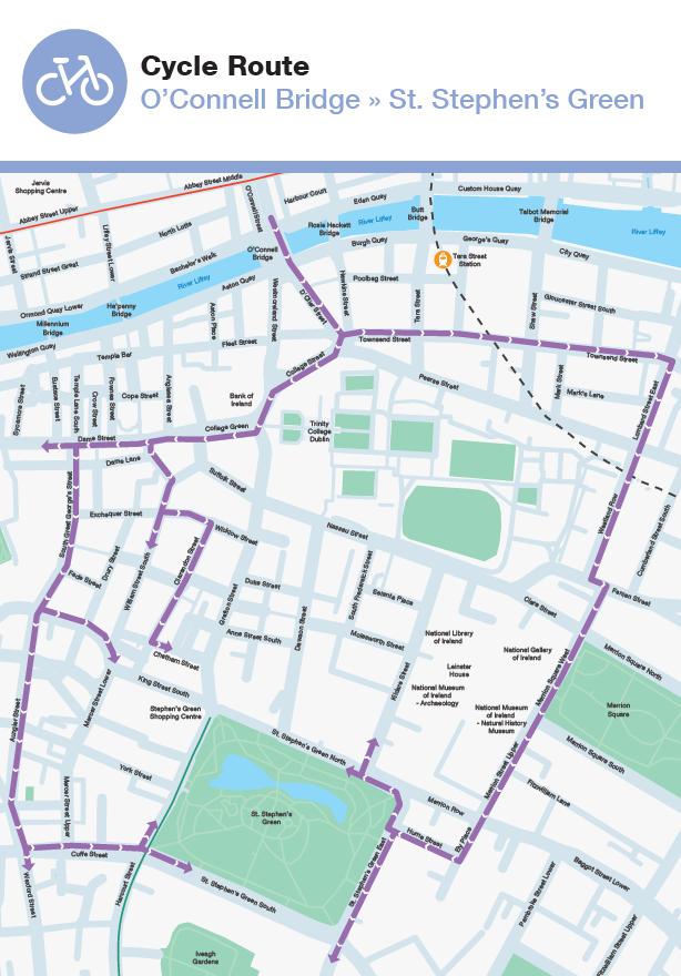
36 Lower Grafton Street Nassau Street (Grafton Street to Dawson Street) Dawson Street Where there is no space on links to accommodate cycling, cycling should be advised to dismount and alternative alignments identified and developed. Where crossing angles are too acute, box turn crossings at or close to 90 degrees should be provided or, if this is not possible, cycling should not be accommodated. Alternative Routes The introduction of LUAS Cross City has generated some space restraints in the areas of Dawson Street, Nassau Street and Lower Grafton Street, and around Parnell Street. While the city centre remains generally accessible to the bicycle, these changes may inconvenience the bicycle mode to some degree for cross-city trips. For cyclists who wish to traverse the city centre, the attached maps indicate alternative available routes. Cyclists between St. Stephen s Green and O Connell Street have two principal options, namely the South Great George s Street alignment, via College Green, and the Merrion Square / Westland Row alignment. The Northbound and Southbound versions of these routes are attached (see maps Cycle Route St. Stephen s Green to O Connell Bridge, and Cycle Route O Connell Bridge to St. Stephen s Green ). 36

37 37

38 38
39 Development of Additional Proposals The NTA and DCC are examining the potential for cycling capability as follows: (i) (ii) (iii) (iv) cycling in both directions from Dame Street through College Green to Westmoreland Street; a segregated cycle track on College Street, facilitating access to the wide cycle track on College Green in front of the Old Parliament Building (this cycle track to become two-way between the pedestrian crossings at Westmoreland Street and College Green); contraflow cycling on South William Street (with logical connections to adjacent streets and College Green), to provide a parallel cycle route to Grafton Street on the Western side; contraflow cycling on Nassau Street from Kildare Street to the Dawson Street junction. The above proposals are subject to further analysis. 39
40 Tabular Summary of main recommendations / considerations 1. Contra-flow cycle facility from Glover s Alley to Grafton Street to be considered as part of the future public realm scheme in the area; 2. Contra-flow cycling on Kildare Street, and prepare proposals for contraflow cycling on the western end of Molesworth Street; 3. Prepare proposals for contra-flow cycling on Nassau Street between Kildare Street and Dawson Street; 4. Advise against cycling along the LCC alignment between Duke Street/Dawson Lane and College Green in both directions; 5. Provide for two-way cycling in College Green, connecting Dame Street to Westmoreland Street; 6. Prepare proposals for a segregated cycle track on College Street, connecting D Olier Street / Hawkins Street / Pearse Street to Westmoreland Street; 7. Provide for box turns at O Connell Bridge; 8. Monitor / Review cyclist use at O Connell Street / Middle Abbey Street and propose intervention(s) if required; 9. Provide a cycle crossing for turning right from Parnell Street to Parnell Square West; 10. Cyclist movements at Broadstone Plaza - Constitution Hill - Western Way DIT Grangegorman to be reviewed to ensure cyclists are adequately provided for; 11. Advise an alternative cycle route for cyclists approaching the Dominick Street-Parnell Street junction (south-bound); 12. Advise an alternative cycle route to the left turn into Parnell Street from Cavendish Row; 13. Review the overall O Connell Street / Parnell Street / Cavendish junction operation and layout; 14. Advise an alternative cycle route to the left turn into Marlborough Street from Parnell Street; 15. Advise alternative routes to cycling in the Marlborough Street - Abbey Street junction; 16. Prepare proposals for contraflow cycling on South William Street; 17. Install box turns at various locations; 18. Provide road markings for guidance at various locations to ensure rail crossings are undertaken by cyclists as close to 90 degrees as possible. 40
College Green traffic management changes
 College Green traffic management changes No through east-west traffic movements in the College Green area except for pedestrians and cyclists. Two-way bus and tram movements on Lower Grafton Street and
Part VII Application For Revised South Side Traffic Management Works To Facilitate Luas BXD
 Dublin Cycling Campaign P.O. Box 10295, Dublin 3. Email info@dublincycling.ie www.dublincycling.ie Executive Manager, Planning Department, Dublin City Council, Civic Offices, Wood Quay, Dublin 8 4 February
Frascati Road and Temple Hill Route Improvements. Outline Design Report to Accompany Public consultation
 Frascati Road and Temple Hill Route Improvements Outline Design Report to Accompany Public consultation September 2013 Background: Dún Laoghaire-Rathdown is committed to providing high quality pedestrian
Improving Cyclist Safety at the Dundas Street West and Sterling Road Intersection
 STAFF REPORT ACTION REQUIRED Improving Cyclist Safety at the Dundas Street West and Sterling Road Intersection Date: August 17, 2012 To: From: Wards: Reference Number: Public Works and Infrastructure Committee
College Green Road Re-alignment Scheme Report to South East Area Committee Proposed Part VIII Application
 College Green Road Re-alignment Scheme Report to South East Area Committee Proposed Part VIII Application Christopher Manzira, Senior Executive Engineer Roads & Traffic Planning Environment and Transportation
4. Guided Bus Explained
 4. Guided Bus Explained Contents 1 INTRODUCTION... 2 Structure of this report... 2 2 KERB GUIDED BUS... 3 Overview... 3 Kerb guidance... 3 Figures Figure 2.1 Figure 2.2 Figure 2.3 Figure 2.4 Figure 2.5
Rhebogue Neighbourhood Greenway. Road Safety Audit Stage 2
 Rhebogue Neighbourhood Greenway Road Safety Audit Stage 2 Report Number: 12/007/00/00057 July 2014 Mid West National Road Design Office Lissanalta House, Dooradoyle County Limerick Tel: 061 496 800 Fax:
CITY OF OTTAWA ROADWAY MODIFICATION APPROVAL UNDER DELEGATED AUTHORITY
 RMA-2015-ATM-038 CITY OF OTTAWA ROADWAY MODIFICATION APPROVAL UNDER DELEGATED AUTHORITY DATE: April 22, 2015 SUBJECT Approval of Roadway Modifications Recommended through an Area Traffic Management Study
ONE SIZE DOESN T FIT ALL RECONCILING OVERLAPPING TRANSPORT NETWORKS IN A CONSTRAINED URBAN ENVIRONMENT
 One Size Doesn t Fit All S Corbett, C Chenery Page 1 ONE SIZE DOESN T FIT ALL RECONCILING OVERLAPPING TRANSPORT NETWORKS IN A CONSTRAINED URBAN ENVIRONMENT Authors/Presenters: Sam Corbett, Principal Transport
2.0 LANE WIDTHS GUIDELINE
 2.0 LANE WIDTHS GUIDELINE Road Engineering Design Guidelines Version 2.0.1 May 2018 City of Toronto, Transportation Services City of Toronto Page 0 Background In early 2014, Transportation Services initiated
SLOUGH Stage 3 Road Safety Audit of A4 London Road, M4 J5 to Sutton Lane
 SLOUGH Stage 3 Road Safety Audit of A4 London Road, M4 J5 to Sutton Lane Exception Report Client Officer Rudo Beremauro Date 20 January 2015 RSA /Project Sponsor s Contents Section 3 Project Sponsor's
Dún Laoghaire Rathdown County Council. Luas to Dart via UCD Cycle and Pedestrian Route
 Dún Laoghaire Rathdown County Council Luas to Dart via UCD Cycle and Pedestrian Route October 2012 Luas to Dart via UCD Cycle and Pedestrian Route DOCUMENT CONTROL SHEET Client: Project Title: Document
Report on trends in mode share of vehicles and people crossing the Canal Cordon to 2013
 Report on trends in mode share of vehicles and people crossing the Canal Cordon 2006 to 2013 Dublin City Council, National Transport Authority, Civic Offices, Dun Scèine, Wood Quay, Harcourt Lane, Dublin
Derby Cycling Group, c/o 126, Station road, Mickleover, Derby, DE3 9FN. Date: 20 th November, 2018.
 Your Ref: Derby City Council Air Quality - Preferred Option Nov 2018 Derby Cycling Group, c/o 126, Station road, Mickleover, Derby, DE3 9FN Date: 20 th November, 2018. 1. Introduction: 1.1. Derby Cycling
Sandyford Cycle Route (Kilgobbin / Drummartin Link Road)
") Sandyford Cycle Route (Kilgobbin / Drummartin Link Road) Public Consultation Report on Submissions Client: Dun Laoghaire-Rathdown County Council Date: May 2018 Job Number: 15_116B Clifton Scannell Emerson
Sandyford Cycle Route (Kilgobbin / Drummartin Link Road) Public Consultation Report on Submissions Client: Dun Laoghaire-Rathdown County Council Date: May 2018 Job Number: 15_116B Clifton Scannell Emerson
May Canal Cordon Report 2017
 May 2018 Canal Cordon Report 2017 Report on trends in mode share of vehicles and people crossing the Canal Cordon to 2017 2 Analysis of trends in mode share of people crossing the canal cordon - 2017 Contents
Dublin City Centre Transport Study EXECUTIVE SUMMARY
 Dublin City Centre Transport Study The Study seeks to address the imminent transport issues facing the core city centre area, to facilitate the implementation of the Dublin City Council Development Plan,
College Green Submission May 2016 Executive Summary
 College Green Submission May 2016 Executive Summary The advent of the Luas Cross City in 2017 will bring major changes to Dublin city. The city s central spine which will now be used by Luas, has for many
Accommodating Cyclists at Signalised Intersections
 Accommodating Cyclists at Signalised Intersections Axel Wilke Senior Traffic Engineer, Christchurch City Council Axel.Wilke@ccc.govt.nz Glen Koorey Transportation Lecturer, University of Canterbury Glen.Koorey@canterbury.ac.nz
Chelmsford City Growth Package
 Chelmsford City Growth Package Public Consultation Document Volume 2 West Chelmsford July - August 2017 Chelmsford City Growth Package Public Consultation Document - Volume 2 - West Chelmsford Contents
TRANSPORT AND MOVEMENT
 TRANSPORT AND MOVEMENT Movement Strategy Public Transport Cycling and Walking Road Network Parking Standards Transport Impact Assessments Traffic Management Policies DRAFT POOLBEG PLANNING SCHEME Movement
West Midlands Cycle Design Guidance Cycling and the Midland Metro
 Transport for the West Midlands Cycling and the Midland Metro September 2017 Project Code: 02821 Phil Jones Associates Ltd Seven House High Street Longbridge Birmingham B31 2UQ philjonesassociates.co.uk
Maynooth Cycling Submission on North South Corridor
 Maynooth Cycling Submission on North South Corridor Maynooth Cycling welcomes the intention to improve facilities and quality of service for pedestrians and cyclists in Maynooth. In particular, we strongly
Strategic Director for Environment. Enclosures Appendix A - Option drawings. Jamie Blake- Strategic Director for Environment
 Chipping Barnet Area Committee 9 July 2018 Title Report of Wards Status Urgent Key Cromer Road Request for 20mph Zone Strategic Director for Environment High Barnet Public No No Enclosures Appendix A -
SCHEME DESIGN AND ENGINEERING
 THE NORTH SOMERSET COUNCIL (SOUTH BRISTOL LINK CLASSIFIED ROAD) SIDE ROADS ORDER 2013 THE NORTH SOMERSET COUNCIL (SOUTH BRISTOL LINK) COMPULSORY PURCHASE ORDER 2013 THE NORTH SOMERSET COUNCIL (SOUTH BRISTOL
102 Avenue Corridor Review
 February 26, 2015 102 Avenue Corridor Review Transportation Association of Canada Road Safety Engineering Award Submission for the City of Edmonton Introduction Transportation Association of Canada Road
Frome Street Bicycle Route
 The Adelaide City Council invites engagement from the community about Frome Street Bicycle Route Project Summary Adelaide City Council is seeking feedback on design options to construct bicycle facilities
Toronto and East York Community Council. Director, Transportation Services, Toronto and East York District
 No Turn on Red Regulations STAFF REPORT ACTION REQUIRED Date: June 1, 2010 To: From: Toronto and East York Community Council Director, Transportation Services, Toronto and East York District Wards: Trinity
Dodder Greenway Emerging Preferred Route Consultation - October 2018
 Dodder Greenway Emerging Preferred Route Consultation - October 2018 1.0 Introduction Dublin Cycling Campaign is the advocacy group for cycling in Dublin. Dublin Cycling Campaign is the leading member
EXECUTIVE SUMMARY Callan Park accommodates travel from a wide range of transport modes, including walking, cycling, bus and light rail.
 TRANSPORT AND ACCESS EXECUTIVE SUMMARY Callan Park accommodates travel from a wide range of transport modes, including walking, cycling, bus and light rail. Whilst there are some walking facilities within
Appendix 12 Parking on footways and verges
 Appendix 12 Parking on footways and verges Legal position Parking on footways and verges whether wholly or partly is banned throughout London, unless signs are placed to allow parking. The ban requires
Chapter 7 - Rural Roads
 Chapter 7 - Rural Roads Rural Roads On a significant length of the National Cycle Network cyclists will share rural roads with other traffic. The objective is to incorporate into the National Cycle Network
MILTON ROAD LLF PROJECT UPDATE
 Greater Cambridge City Deal MILTON ROAD LLF PROJECT UPDATE 9 th May 2017 Project objectives Comprehensive priority for buses in both directions wherever practicable; Additional capacity for sustainable
1 This technical note considers the issues associated with the use of tidal flow bus lanes on key public transport corridors in Cambridge.
 TECHNICAL NOTE: TIDAL FLOW BUS LANE OPTION ASSESSMENT Purpose 1 This technical note considers the issues associated with the use of tidal flow bus lanes on key public transport corridors in Cambridge.
11.2 Detailed Checklists CHECKLIST 1: FEASIBILITY STAGE AUDIT. 1.1 General topics Scope of project; function; traffic mix
 11.2 Detailed Checklists CHECKLIST 1: FEASIBILITY STAGE AUDIT 1.1 General topics 1.1.1 Scope of project; function; traffic mix What is the intended function of the scheme? Is the design consistent with
Proposed Amendment to Grangegorman Planning Scheme Prussia Street Addendum Traffic and Transport Assessment
 Proposed Amendment to Grangegorman Planning Scheme 2012 Prussia Street Addendum Traffic and Transport Assessment 16 th June 2017 Proposed Change to Grangegorman Planning Scheme Quality information Prepared
Progress update on the Sustainable Movement Corridor scheme Guildford Borough Council, June 2016
 Progress update on the Sustainable Movement Corridor scheme Guildford Borough Council, June 2016 1. Introduction The concept of the Sustainable Movement Corridor (hereafter the SMC ) was first developed
Luas Broombridge. Annex C.1 Human Beings: Noise Modelling and Predictions Report. St. Stephen s Green to Broombridge (Line BXD) Broombridge.
 Broombridge.") Broombridge Luas Broombridge St. Stephen s Green to Broombridge (Line BXD) Annex C.1 Human Beings: Noise Modelling and Predictions Report Cabra Phibsborough Grangegorman Broadstone - DIT Parnell Dominick
Broombridge Luas Broombridge St. Stephen s Green to Broombridge (Line BXD) Annex C.1 Human Beings: Noise Modelling and Predictions Report Cabra Phibsborough Grangegorman Broadstone - DIT Parnell Dominick
10.0 CURB EXTENSIONS GUIDELINE
 10.0 CURB EXTENSIONS GUIDELINE Road Engineering Design Guidelines Version 1.0 March 2017 City of Toronto, Transportation Services City of Toronto Page 0 Background In early 2014, Transportation Services
Agenda Item 34. N11 - Brewery Road Improvement Scheme
 Agenda Item 34 N11 - Brewery Road Improvement Scheme Public Consultation Report on Submissions Client: Dún Laoghaire-Rathdown County Council Date: November 2017 Job Number: 13_066A Document Pack Page 11
IAN WHITE ASSOCIATES. Crawley Station Gateway Public Realm
 IAN WHITE ASSOCIATES Crawley Station Gateway Public Realm contents 1. objectives & client brief 2. site appraisal 3. best practice guidance 4. design concept 1. objectives & client brief Crawley Train
Marcus Jones, TRL. Presented by Name Here Job Title - Date
 Segregation Insert the title and of priority your at presentation junctions: a here discussion Marcus Jones, TRL Presented by Name Here Job Title - Date Background: TfL cycle facility trials Infrastructure
Public Consultation on Braintree Integrated Transport Package (ITP) HAVE YOUR. Consultation open from 24 September to 5 November 2018 SAY
 HAVE YOUR. Consultation open from 24 September to 5 November 2018 SAY") Public Consultation on Braintree Integrated Transport Package (ITP) HAVE YOUR SAY Consultation open from 24 September to 5 November 2018 Contents Introduction 3 Background 4 Springwood Drive Roundabout
Public Consultation on Braintree Integrated Transport Package (ITP) HAVE YOUR SAY Consultation open from 24 September to 5 November 2018 Contents Introduction 3 Background 4 Springwood Drive Roundabout
A105 South of Ecclesbourne Gardens to Oakthorpe Road
 Cycle Enfield - Section 1 A105 South of Ecclesbourne Gardens to Oakthorpe Road Stage 2 Road Safety Audit Ref: 2759.03.01/032/A105/BOR/2016 Prepared for: London Borough of Enfield By: Road Safety Audit,
Cabinet Member for Highways & Streetscene. Highway Infrastructure Manager
 LONDON BOROUGH OF RICHMOND UPON THAMES DATE: AUGUST 2015 DECISION MAKER: LEAD OFFICER: SUBJECT: WARDS: Cabinet Member for Highways & Streetscene Highway Infrastructure Manager PROPOSED CYCLING IMPROVEMENTS
The parade will now travel along O Connell Street EAST, O Connell Bridge EAST and on to Westmoreland Street.
 St. Patrick's Festival will run from Thursday 16 th to Sunday 19th March 2017, with the Festival Parade taking place on Friday 17th March starting 12:00hrs, starting from Granby Row. 1. PARADE ROUTE CHANGES
2. NORTEL CARLING CAMPUS EXPANSION - PROPOSED MODIFICATIONS TO MOODIE DRIVE (REGIONAL ROAD 59) AND HIGHWAY 417 INTERCHANGE
 AND HIGHWAY 417 INTERCHANGE") 2. NORTEL CARLING CAMPUS EXPANSION - PROPOSED MODIFICATIONS TO MOODIE DRIVE (REGIONAL ROAD 59) AND HIGHWAY 417 INTERCHANGE COMMITTEE RECOMMENDATIONS AS AMENDED That Council approve: 1. The endorsement
2. NORTEL CARLING CAMPUS EXPANSION - PROPOSED MODIFICATIONS TO MOODIE DRIVE (REGIONAL ROAD 59) AND HIGHWAY 417 INTERCHANGE COMMITTEE RECOMMENDATIONS AS AMENDED That Council approve: 1. The endorsement
Welcome. If you have any questions or comments on the project, please contact:
 Welcome This drop-in public open house is intended to provide information about the Bay Street bike lanes project. This project proposes a dedicated cycling facility along Bay Street between Aberdeen Avenue
Design and Installation of Low Level Cycle Signals
 Transport for London Surface Transport Management System Document Guidance Note Design and Installation of Low Level Cycle Signals Document reference: SQA-0651 - Issue: Draft out of date information. 1
Bus and Transit Lane Review Update
 Board Meeting / 25 February 2013 Agenda Item no.8(i) Bus and Transit Lane Review Update Glossary Auckland Transport New Zealand Transport Agency Transit Two Transit Three (AT) (NZTA) (T2) (T3) Executive
FAQ s Walsh Road / Ferguson Road Pilot Scheme
 FAQ s Walsh Road / Ferguson Road Pilot Scheme What is happening? Traffic calming measures are being installed as a pilot. Temporary Bollards will be installed to the east of 1 Ferguson Road and a Temporary
Junction Design with Traffic Signals
 Junction Design with Traffic Signals Wednesday March 2 nd 2016 Overview Introduction Context Conventional Approach Sustainable Approach Analysis Design Summary Introduction What are Traffic Signals? Purpose
Cycle Superhighway 4 from Tower Bridge to Greenwich
 Cycle Superhighway 4 from Tower Bridge to Greenwich About Sustrans Sustrans is the charity making it easier for people to walk and cycle. We are engineers and educators, experts and advocates. We connect
DESIGN CODE. Enterprise West Harlow London Road North Design Code 21
 DESIGN CODE Enterprise West Essex @ Harlow London Road North Design Code 21 4 MAXIMUM BUILDING HEIGHTS 4.1 Table 4A sets out maximum building height standards for each character area within the LDO boundary.
APPENDIX F: TECHNICAL NOTE 22 (VICARAGE ROAD JUNCTION)
") APPENDIX F: TECHNICAL NOTE 22 (VICARAGE ROAD JUNCTION) West Midlands Interchange Transport Assessment DCO Submission WEST MIDLANDS INTERCHANGE SUBJECT: Technical Note 22 Review of Vicarage Road Junction
APPENDIX F: TECHNICAL NOTE 22 (VICARAGE ROAD JUNCTION) West Midlands Interchange Transport Assessment DCO Submission WEST MIDLANDS INTERCHANGE SUBJECT: Technical Note 22 Review of Vicarage Road Junction
Wicklow County Council Chomairle Chontae Chill Mhantáin. Traffic Calming Policy
 Chomairle Chontae Chill Mhantáin Adopted by Wicklow County Council on the 11th of June, 2012 Contents Section Page 1. Introduction 3 2. Legislation 3 3. Guidance Documentation 3 4. Policy Objectives &
Perne Rd / Radegund Rd Roundabout Cambridge
 Perne Rd / Radegund Rd Roundabout Cambridge The conversion of an conventional urban roundabout to continental geometry A little bit of history The first traffic roundabout was built in Sollershott, Letchworth
The existing site constraints which may be encountered for the A428 scheme proposals are divided into sections as follows.
 Project: A428 Study To: Cambridgeshire County Council Subject: Tidal Bus lane Review From: Atkins Date: 24 May 2016 cc: Introduction As part of the A428 Corridor Study to improve the bus journey time between
Richmond-Adelaide Cycle Tracks
 Public Drop-In Event Richmond-Adelaide Cycle Tracks June 25, 2018 12:00 p.m. 3:00 p.m. 4:30 p.m. 7:30 p.m. Metro Hall, Rotunda 55 John Street 1 Purpose of Event In Scope Communicate an update about the
The Cabinet Member for Highways & Streetscene. Aurang Zeb - Head of Highways & Transport
 LONDON BOROUGH OF RICHMOND UPON THAMES Cabinet Member Decision DATE: January 2012 REPORT OF: LEAD OFFICER: SUBJECT: WARDS: The Cabinet Member for Highways & Streetscene Aurang Zeb - Head of Highways &
SAN FRANCISCO MUNICIPAL TRANSPORTATION AGENCY
 THIS PRINT COVERS CALENDAR ITEM NO. : 10.3 DIVISION: Sustainable Streets Division BRIEF DESCRIPTION: SAN FRANCISCO MUNICIPAL TRANSPORTATION AGENCY Approving traffic and parking modifications to install
Douglas LUTS - Work Packages WP1, WP2 & WP11
 The Tailor's Hall, Back Lane, Dublin 8. E: Damien.otuama@antaisce.org T: 01-7077064 M: +353-87-2840799 Peter O'Donoghue SE Traffic and Transportation Section Cork County Council Floor 10 County Hall Carrigrohane
DYNAMIC LANES FOR AUCKLAND
 Dynamic Lanes for Auckland MENEZES M. and INMAN R. Page 1 DYNAMIC LANES FOR AUCKLAND Authors: INMAN, Robert BA (Hons) Previously Auckland Transport Senior Traffic Engineer Now Aurecon Robert.Inman@aurecongroup.com
Public Works and Infrastructure Committee. General Manager, Transportation Services
 STAFF REPORT ACTION REQUIRED Extending the Bay Street Bicycle Lanes Date: May 16, 2013 To: From: Public Works and Infrastructure Committee General Manager, Transportation Services Wards: Toronto Centre
Recommended Improvements - Ruby/Banning Neighbourhood Greenway
 MORE PEOPLE BIKING MORE OFTEN Ruby and Banning Streets have the potential to be an important part of the City of Winnipeg s bicycle network, with direct, low stress access to a community centre, multiple
National Cycle Network Route 81 Wolverhampton Cross City Route August 2005
 Page 12 Buses often stop in Lichfield Street and there is no space to pass. Should an NCN route be following a road which is heavily congested with buses and diesel fumes? 14. Railway Drive The dropped
Issues at T junctions:
 TheSlade_PublicConsulationPlans_March2017.pdf These comments relate to junction designs in this phase of the project on The Slade. Comments begin with the northernmost junction: Girdlestone Rd and continue
Side Roads and Other Non-Signalised Junctions
 Green Surfacing Sections of the Cycle Superhighway are marked with green paint these highlight sections where people cycling the Superhighway are likely to come into contact with walkers, drivers, or other
5. RUNNINGWAY GUIDELINES
 5. RUNNINGWAY GUIDELINES These guidelines should be considered collectively when making runningway decisions. A runningway is the linear component of the transit system that forms the right-of-way reserved
Dublin City Cycle Scheme
 Dublin City Cycle Scheme Phase 3: Potential Locations Oct. 2008 PLANNING & ROADS CYCLE WORKING GROUP ROB FENNELLY JAMES CAHILL ALL LOCATIONS ARE INDICATIVELY SHOWN. ALL SITES ARE SUBJECT TO SERVICES INVESTIGATION.
PAEKĀKĀRIKI HILL ROAD / BEACH ROAD / SH1 INTERSECTION PROGRESS REPORT
 Chairperson and Committee Members ENVIRONMENT AND COMMUNITY DEVELOPMENT COMMITTEE 6 DECEMBER 2011 Meeting Status: Public Purpose of Report: For Decision PAEKĀKĀRIKI HILL ROAD / BEACH ROAD / SH1 INTERSECTION
CAIRNGORMS NATIONAL PARK AUTHORITY FOR DECISION
 CAIRNGORMS NATIONAL PARK AUTHORITY FOR DECISION Title: Prepared by: A9 Dualling Project: Dalraddy to Slochd Murray Ferguson, Director of Planning and Rural Development and Gavin Miles, Head of Planning
Comments on the Hailsham to Eastbourne Sustainable Transport Corridor
 Comments on the Hailsham to Eastbourne Sustainable Transport Corridor Version 1.1 25/01/2015 Paul Humphreys 1 Table of Contents Version Control... 2 Summary... 2 Rationale provided by ESCC... 3 The ESCC
CURBSIDE ACTIVITY DESIGN
 5 CURBSIDE ACTIVITY DESIGN This chapter provides design guidance for separated bike lanes adjacent to curbside activities including parking, loading and bus stops. Typical configurations are presented
Duwamish Way-finding and CTR Report
 V. North Tukwila When the North Tukwila Manufacturing and Industrial Center was designated in 1992 as part of the region s land use and transportation plan, the plan called for the area to set a light-rail
Ministry of Education Flat Bush School Notice of Requirement. Integrated Transportation Assessment Report. February 2016
 Ministry of Education Flat Bush School Notice of Requirement Integrated Transportation Assessment Report February 2016 TDG Ref: 12988-2 151105 ita flat bush.docx Ministry of Education Flat Bush School
TS 109 DURHAM ROAD QTC PHASE 4 PROJECT PROPOSAL. Page 1
 TS 109 DURHAM ROAD QTC PHASE 4 PROJECT PROPOSAL Page 1 Table of Contents 1.0 Introduction... 3 2.0 Project Overview... 3 3.0 Project Proposals... 4 3.1 Enfield Road / Durham Road Junction... 3 5 3.2 Summerfield
Submission on Clontarf to City Centre Cycle Route with signatures of 1,493 people
 Submission on Clontarf to City Centre Cycle Route with signatures of 1,493 people Route should use a fully segregated two-way cycle path Contact details Cian Ginty - editor, IrishCycle.com - cian.ginty@gmail.com
Principles. 4biii. Good Urban Design
 Principles Good Urban Design The Sherford approach to the hierarchy of travel modes is fostered and encouraged by a combination of influences. These are as follows, described in further detail below: Town
Guide to the Cycle Enfield Public Consultation on Enfield Town. Produced by the Save Our Enfield Town Campaign Group
 Guide to the Cycle Enfield Public Consultation on Enfield Town Produced by the Save Our Enfield Town Campaign Group What s in this guide? Introduction Page 3 What Enfield Council says about Option 1 Page
2014/2015 BIKE ROUTE PLAN 83 AVENUE PROTECTED BIKE LANE
 About the Project 2014/2015 BIKE ROUTE PLAN The City of Edmonton is planning a major bike route on the south side of Edmonton. This bike route is one part of a plan to provide citizens with transportation
Simulation Analysis of Intersection Treatments for Cycle Tracks
 Abstract Simulation Analysis of Intersection Treatments for Cycle Tracks The increased use of cycle tracks also known as protected bike lanes has led to investigations of how to accommodate them at intersections.
C.A.R.S. Project Design Report.
 C.A.R.S. Project Design Report. PRODUCED BY: Browne, A. Kennedy, M. Dolan, N. Selman, C. STUDENT NO: DATE DUE: COURSE: LECTURER: C09365788-C09686908-D11125480-C08868352 20-April-2012 Dt004/3 Civil Engineering
Citizens Cycling Jury. Sharing the Roads Safely Final Recommendations. November RAA Response to Recommendations
 Citizens Cycling Jury Sharing the Roads Safely Final Recommendations November 2014 RAA Response to Recommendations Background The Citizen s Jury Report entitled Sharing the Road Safely was presented to
Tel: Karime Hassan Chief Executive Exeter City Council Civic Centre Paris Street Exeter EX1 1JN
 Page 1 of 6 Karime Hassan Chief Executive Exeter City Council Civic Centre Paris Street Exeter EX1 1JN Dear Mr Hassan 14th September 2015 Re: Development of Bus & Coach Station Site Following the submission
Chapter 4 Route Window C3 Hyde Park and Park Lane shafts. Transport for London
 Chapter 4 Route Window C3 Hyde Park and Park Lane shafts Transport for London HYDE PARK AND PARK LANE SHAFTS 4 Route Window C3 Hyde Park and Park Lane shafts Introduction 4.1 In this route window, which
Corporate. Report COUNCIL DATE: May 25, 1998 NO: R1500 REGULAR COUNCIL. TO: Mayor & Council DATE: April 27, 1998
 R1500 : Traffic Safety at 25 Avenue and 128 Street Intersection Corporate NO: R1500 Report COUNCIL DATE: May 25, 1998 REGULAR COUNCIL TO: Mayor & Council DATE: April 27, 1998 FROM: General Manager, Engineering
Auckland Transport s responses to feedback on proposed upgrades to the intersection of Mercari way and Don Mckinnon Drive
 s to feedback on proposed upgrades to the intersection of way and Don Mckinnon Drive Points raised through feedback process 1 Congestion The proposal will improve traffic flow through the intersection
A plan for improved motor vehicle access on Railroad Avenue in Provincetown
 A plan for improved motor vehicle access on Railroad Avenue in Provincetown February 2011 A plan for improved motor vehicle access on Railroad Avenue in Provincetown INTRODUCTION AND PROBLEM IDENTIFICATION
A105 Green Lanes junction with Bourne Hill / Hedge Lane
 Cycle Enfield - Section 5 A105 Green Lanes junction with Bourne Hill / Hedge Lane Stage 2 Road Safety Audit Ref: 2759.03.05/032/A105/BOR/2016 Prepared for: London Borough of Enfield By: Road Safety Audit,
Appendix F CAPITA Technical Audit
 Appendix F CAPITA Technical Audit West Hendon - Major Review of Technical Audit Responses 14 June 2016 Quality Management Quality Management Job No Project Location Title CS/086106 West Hendon - Major
Re: N71 Muckross Road Traffic Calming Scheme Part 8 and Section 38
 Administrative Officer, Kerry County Council, Roads, Transportation & Safety Department, Room 115, Áras an Chontae, Rathass, Tralee, Co. Kerry. The Tailor's Hall, Back Lane, Dublin 8. The Tailor's Hall,
Appendix A Type of Traffic Calming Measures Engineering Solutions
 Appendix A Type of Traffic Calming Measures Engineering Solutions PHYSICAL MEASURES Central Hatching The major consideration of this feature is that, these markings can only be laid down the centre of
Determining bicycle infrastructure preferences A case study of Dublin
 *Manuscript Click here to view linked References 1 Determining bicycle infrastructure preferences A case study of Dublin Brian Caulfield 1, Elaine Brick 2, Orla Thérèse McCarthy 1 1 Department of Civil,
CHECKLIST 2: PRELIMINARY DESIGN STAGE AUDIT
 CHECKLIST 2: PRELIMINARY DESIGN STAGE AUDIT 2.1 General topics 2.1.1 Changes since previous audit Do the conditions for which the scheme was originally designed still apply? (for example, no changes to
2014/2015 BIKE ROUTE PLAN 83 AVENUE PROTECTED BIKE LANE
 About the Project The City of Edmonton is planning a major bike route on the southside of Edmonton. The Strathcona Bike Route will connect the communities of Strathcona, Garneau and the University area,
Integrated Regional Traffic Management. Michael Aherne Technical Director POLIS Conference 2009
 Integrated Regional Traffic Management Michael Aherne Technical Director POLIS Conference 2009 M50 finish Public Transport and Pedestrians College Green The Spatial Perspective What Could has
A127/A130 Fairglen Interchange Improvement Schemes. Information Leaflet February 2017
 A127/A130 Fairglen Interchange Improvement Schemes Information Leaflet February 2017 1 2 Foreword By Councillor Kevin Bentley Essex is continuing to grow as a vibrant economic hub and as a fantastic place
Footpath design. A guide to creating footpaths that are safe, comfortable, and easy to use
 Footpath design A guide to creating footpaths that are safe, comfortable, and easy to use November 2013 Contents Introduction / 1 Zoning system / 2 Width / 4 Height / 5 Surface / 5 Footpath elements /
sessions. The opinions of local people will help decide which of these two options is taken forward to be built.
 A4018 FAQs Why are no bus lanes proposed north of Crow Lane? Inbound and outbound bus lanes were considered north of the Crow Lane junction, but they took away capacity from other traffic on the approach