COAL CREEK PARKWAY CULVERT/BRIDGE CITY OF BELLEVUE
|
|
|
- Frank Barrett
- 5 years ago
- Views:
Transcription
1

2


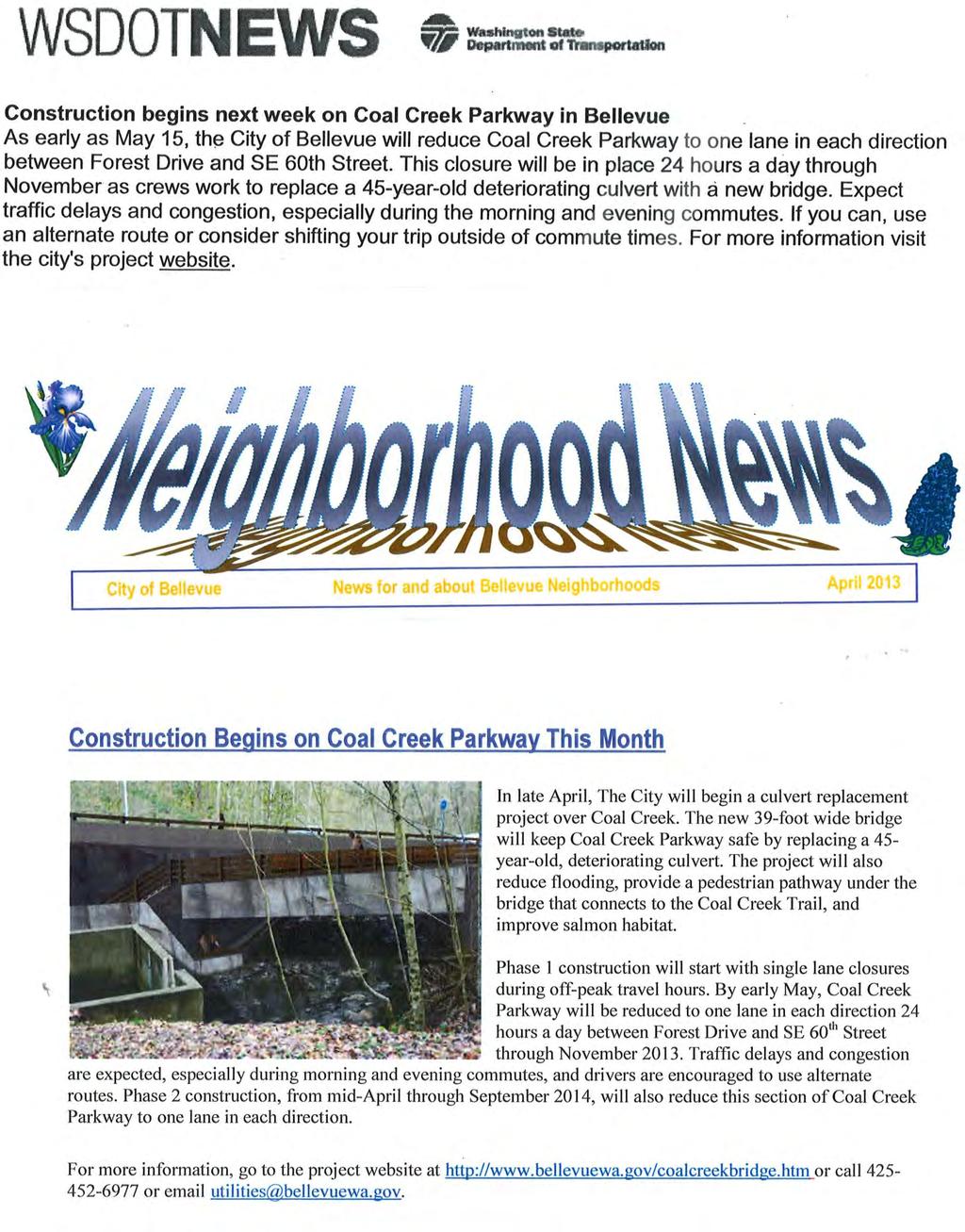
3 Overview The Coal Creek Parkway Culvert/Bridge Replacement Project is an environmental project involving a structure that serves to improve connectivity of both wildlife and fish habitat, creates access to miles of trails for the public to enjoy, and maintains a critical regional transportation link while continuing critical utility services. The project also repairs a high-risk asset and increases the longevity and safety of infrastructure, including a critical petroleum pipeline. This project was a success because of collaboration and partnership across many parties. This critical project began in May 2013, was completed in September 2014, and benefits the community in many important ways: The new 39-foot culvert/bridge: o Replaces an aging culvert and serves to carry Coal Creek, o Keeps Coal Creek Parkway safe for 28,000 motorists who use it daily, o Provides a safe relocation for the gas and petroleum pipelines and other utilities in the road embankment. A new pedestrian walkway under the road allows walkers and hikers to safely cross under Coal Creek Parkway and connect to the Coal Creek Trail. Stream restoration improves fish habitat and allows fish passage. A viewing area offers visitors a scenic place to look for salmon. Background The City of Bellevue s Utilities Department policies provide for identification and implementation of capital projects through their Capital Improvement Program (CIP) to rehabilitate or replace The City of Bellevue s stormwater mission is to provide a storm and surface water system that controls damage from storms, protects surface water quality, supports fish and wildlife habitat, and protects the environment. Replacing the aging culvert (above left) under Coal Creek Parkway and renovating the stream met all of these objectives, as well as keeping the roadway safe for 28,000 motorists who use it each day. 1


4 deteriorated elements of the stormwater system to ensure that utility customers are provided with consistent and reliable service. An engineering analysis determined that the City s 9-foot diameter, 45-year-old culvert under Coal Creek Parkway, a major arterial in Bellevue, was in poor condition and had to be replaced. The Utilities CIP went through a prioritization process to assess this project against other City needs, and it was given a high priority because of potentially critical safety considerations. The culvert was considered a high priority due to these existing deficiencies and potential risks of failure: Deformation of the culvert and gabion walls presented a significant risk of roadway failure that would impact the nearly 28,000 travelers who use Coal Creek Parkway each day Roadway failure could interrupt and damage critical utility infrastructure, including: o Fiber optic cables, o A 12-inch high-pressure natural gas main, o Two Olympic Pipelines (OPL), 16-inch and 20-inch petroleum pipelines operated by BP Pipelines (BP). Rupturing these gas and fuel lines would have significant public safety and environmental consequences. The inlet to the culvert was hydraulically limited and susceptible to blockage due to debris and deformation creating a significant flooding and safety risk. Existing weirs downstream of the project area did not meet current juvenile salmonid passage criteria. Velocities within the culvert and a vertical drop at the outlet of the culvert classified the culvert as a partial fish passage barrier. The existing culvert was susceptible to damage and flooding due to blockage by woody debris. An emergency repair was completed in 2012 to repair the inlet of the culvert and patch the corrosion along the bottom of the CMP structure. However, permitting agencies required a permanent fix within 5 years of the repair work. Because of the complex utility relocations and the need to keep the road open to traffic, the project needed to be constructed one half at a time, in two phases, with the utilities being relocated in between phases. The total construction duration was a year and a half. 2

5 Construction Schedule, Management, and Control Techniques The key to making the design and construction of this project successful was teamwork. The effective delivery of this project was the result of a collaborative effort among the City s design consultant CH2M HILL, Bellevue s Utilities, Parks, Transportation, and Development Services Departments, BP, Puget Sound Energy, fiber companies such as Verizon and Zayo, and environmental regulators such as the Washington Department of Fish and Wildlife, the Muckleshoot Tribe and the U.S. Army Corps of Engineers. As mentioned previously, the culvert/bridge had to be constructed in two phases during 2013 and 2014 in order to maintain traffic and safely relocate multiple utilities. In addition to fiber optic cables and a 12-inch Puget Sound Energy Gas Line, two OPL petroleum pipelines had to be moved. Both pipelines sandwiched the existing 9-foot corrugated metal culvert--the 20-inch OPL pipeline was located just over the top of the culvert, while the 16-inch pipeline was just underneath it. Moving the pipelines was a major construction project unto itself and major source of risk. The pipelines are vital to the operation of Sea-Tac International Airport and can only be shut down for a brief few days at several specific times during the year. An elaborate agreement was worked out with BP so that the City s contractor could complete work by a certain date in September and then vacate the site, so that BP s contractor could complete their first phase of work during one of the shutdown windows, to be completed by the end of November. The agreement then called for BP to reopen the roadway during the remainder of the winter until their contractor was ready to return and complete their work. During this time the other utilities were also relocated to the west side of the roadway, so that when the City s contractor began work in 2014, they would be able to move quickly without concern about the pipeline or other utilities being in the way. A further complication was that, since Coal Creek is a fish-bearing stream, subject to requirements of the Endangered Species Act, state and federal permits only allow in-stream work to take place between June 16 and September 30. To make the most of the brief in-stream construction season, the strategy was to construct the new culvert around the existing one. The road embankment was excavated down to near the crown of the existing culvert. Then steel soldier piles were installed and the lid of the new culvert was poured on-grade over the existing culvert. After curing took place, the material under the lid was mined out so that the new stream bed could be constructed. Removal of the decommissioned section of 20-inch OPL petroleum pipeline after it had been re-routed. 3
, traffic was restricted to one lane in each direction on the east half of Coal Creek Parkway.")


6 First Phase May-November 2013 COAL CREEK PARKWAY CULVERT/BRIDGE CITY OF BELLEVUE During the first year of construction (2013), traffic was restricted to one lane in each direction on the east half of Coal Creek Parkway. In August 2013, the first milestone was reached when the lid was poured. Crews worked for six hours to place and finish the concrete. They then covered the finished concrete with wet curing blankets and followed this with a plastic visqueen cover to retain moisture as the concrete cured. Once the west half of the culvert/bridge was constructed, the project site was turned over to BP to relocate their pipelines to the west side of road. After the pipelines were relocated, the west side of the road was repaved, and Coal Creek Parkway was reopened during the winter. First half of culvert/bridge being constructed above (left). Digging out the old material (above right). Below (left), steel lid of culvert/bridge is set, and wet curing blankets are placed on top (right). 4
, traffic was moved to the west side of")


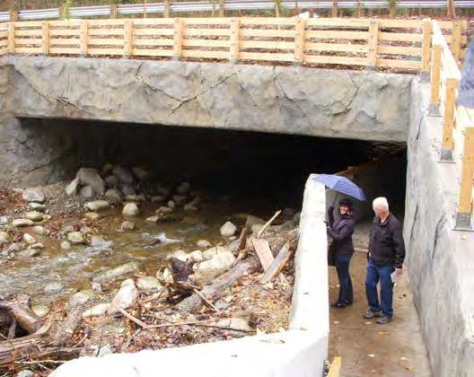
7 Second Phase April-September 2014 During the second year of construction (2014), traffic was moved to the west side of Coal Creek Parkway while the east half of the culvert/bridge was constructed. The new culvert/bridge was built around the old one and the material under the new lid was mined out so the stream channel, stairs, and trail could be built. Mining out the old culvert. Blank concrete walls were transformed into rocks and stone by artisans who sculpted and later painted them to look like natural granite. New culvert being mined out. Old culvert is still in place with stream being bypassed through it. 5


8 Safety Performance COAL CREEK PARKWAY CULVERT/BRIDGE CITY OF BELLEVUE There were zero lost-time injuries during construction of the Coal Creek Parkway Culvert/Bridge a potentially dangerous site with heavy traffic, construction equipment, and relocation of Puget Sound Energy s gas line, two OPL petroleum pipelines, and fiber optic cables. Safety was a number one focus on the job site at all times, while reducing four lanes of traffic to two and redirecting traffic on a major regional roadway. The City of Bellevue had inspectors on site at all times to ensure that safety regulations were followed. Environmental Considerations As noted previously, Coal Creek is a fish-bearing stream subject to requirements of the Endangered Species Act and state and federal permits only allow in-stream work to take place between the very short window of June 16 and September 30. Temporary sediment and erosion controls were installed and maintained throughout construction, including a stream bypass (including fish exclusion prior to establishing the bypass) during the in-stream work window. In addition, New Zealand Mud Snails have emerged as an invasive species of concern and have been detected in other creeks in the City of Bellevue but not Coal Creek. The contract specifications for this project included the development of new requirements for equipment decontamination to reduce the potential spread of this invasive species. Prior to the completion of construction it became evident that the new bridge would also provide a vital link connecting habitat along the Coal Creek Park natural area as deer and wildlife began to use the crossing. To better enable wildlife passage through the project area, wildlife experts were consulted, and fencing and grading were modified so wildlife could more easily cross and access habitat on either side of Coal Creek Parkway without crossing the roadway, which could create a safety hazard. Stream Restoration Build It and They Will Come Restoration of Coal Creek included 5,200 tons of streambed gravels and well over 100 logs to provide fish habitat and pools for fish to hide out and rest in before moving further upstream. Construction of the bridge opened up about a mile of salmon habitat that had been restricted for use for many years. We are already seeing the benefits of this work by observing Coho salmon a mile upstream at a natural waterfall. The City worked with the Muckleshoot Tribe who released over 1,500 hatchery Coho salmon in Coal Creek about a mile downstream. Since then, we have seen 151 Coho along with 35 redds (salmon nests) upstream. Last year, even with 742 salmon released, we did not find any upstream of the culvert. This is evidence that the new habitat and fish-passable stream channel are working well. 6

 and served as a pilot of the draft")
9 Coho eggs should hatch in March, and the fry will live in the stream for about a year before migrating out to the Pacific Ocean. After two years, they should return to Coal Creek. Large wood debris, log structures and root wads were incorporated into the stream design to provide bank protection, energy dissipation and hydraulic complexity to improve habitat in the stream reach. In addition, stream boulders were included to increase channel roughness, including reuse of boulders and erratics encountered in excavation of the structures. The roughened channel design approach employed in the restored reach of Coal Creek was done in collaboration with Washington Department of Fish and Wildlife (WDFW) and served as a pilot of the draft updates to the WDFW fish passage manual to improve juvenile salmonid passage. 7


10 Deteriorating log weirs (left) were blocking salmon passage and were replaced with a new 400-foot roughened stream channel (below). The log jams also provide improved habitat by offering resting pools. 8

11 Since the project was finished and habitat improved, 35 salmon redds (nests) were seen upstream of the site. No salmon redds were observed upstream of the project site last year. 9
 have been spotted upstream of the new culvert, and eggs are expected to hatch in March.")
12 Hikers can take a moment to rest and also look for salmon in the newly restored Coal Creek stream channel. A total of 35 Coho redds (nests) have been spotted upstream of the new culvert, and eggs are expected to hatch in March. Salmon fry will live in Coal Creek for about a year before migrating to the Pacific Ocean. Construction of the culvert/bridge opened up about a mile of salmon habitat that had been restricted for use for many years. Community Relations The Coal Creek Parkway Culvert/Bridge is surrounded by a natural area, and there are no residences or businesses in close proximity. However, an extensive outreach effort was made to reach residents in the nearest neighborhoods and the 28,000 daily motorists using this major arterial who would be impacted by construction of the project. The four lanes of Coal Creek Parkway were reduced to two lanes during the first phase in May-November 2013 and the second phase in April- September One of the biggest challenges was explaining to the public why it was going to take a year and a half, and two construction phases to complete this project. We committed to always have one lane open in each direction on Coal Creek Parkway, and we kept that commitment. We did have to lower the speed limit for safety reasons, however, and traffic was impacted, especially during commute times. Public outreach efforts began with an Open House at City Hall on November 15, 2012 to provide information about the project, allow opportunities for the public to ask questions about the project, and provide feedback on ways to minimize impacts during construction. City and consultant staff were on hand at the Open House to answer questions. Effective display boards were used to explain construction sequencing and impacts. A project handout described the project, its importance, benefits, potential impacts, and construction schedule. Other outreach efforts started several months before the lanes closed and the project began, and included the following: 10


13 Communication Vehicles News releases Web site with alerts when updated Ads in Bellevue Reporter newspaper Short segments on Bellevue s TV show Lake to Lake Meetings/site tours with reporters 11,500 postcards mailed to residences and businesses Articles in community newsletters Articles in City newsletters s to neighborhood associations Websites and newsletters of nearby cities Traffic advisories Electronic signs along Coal Creek Parkway (in the last weeks before construction and prior to public meetings) Utility bill inserts Door-to-door construction notices Social media Facebook, Twitter Q&As for staff answering phones Phone numbers for public to call Presentations were made to the Newcastle City Council and Newport Hills Community Club Ribbon Cutting Event and Site tour on November 21, Nav Otal, City of Bellevue, Utilities Dept. Director (left); Lynne Robinson, Bellevue Councilmember (middle); Brad Miyake, Bellevue City Manager, (right). We reminded the public through multiple communication vehicles that four lanes would open back up for several months in the winter, but that the road would go back to two lanes for the second phase of the project in An important message was that the lane closures were switching to the west half but still one lane in each direction. Emphasizing this message minimized public confusion. The Traffic Advisory that went out weekly and the dedicated website had alerts so that each person who signed up was notified by when new information was posted. Communication efforts continued throughout the project and culminated with a ribbon cutting event on November 21, View a segment about the project on Bellevue s Lake to Lake TV show at 11

14 Examples of outreach, including postcard below that was mailed out to over 11,000 households. 12
15 13


16 Unusual Accomplishments Under Adverse Conditions Management of water (streamflow and groundwater) presented a challenge for the design and construction of the new bridge structure. The contractor installed temporary wells with submersible pumps for de-watering to manage groundwater as needed and treated collected water through portable sedimentation tanks prior to discharge back to the creek downstream of the project area. In addition, a gravity HDPE piped bypass was threaded through the existing culvert to provide bypass of creek flow during the in-stream work window. The bypass plan and dewatering plan maintained a dry work area during several significant storm events with the exception of one event in summer 2014 where some excess flow overwhelmed the bypass and flooded the excavation area. However, containment of the majority of the flow and berms limited the duration of construction delay and impacts to the work area. Additional Considerations Connecting the Trail System During the initial design process, the Utilities and Parks departments determined that it would be beneficial to the City to widen the box culvert from 32 feet to 39 feet in order to add a walkway along the south wall of the culvert for hikers to safely cross under Coal Creek Parkway. This solution would have major safety benefits, as hikers would no longer be tempted to dash across four lanes of busy Coal Creek Parkway. The walkway also eliminated an existing gap in the Coal Creek Park trail system. The trail Entrance to the pedestrian walkway, with Coal Creek to the left and Coal Creek Culvert/Bridge and Parkway to the right. feature was designed and funded in cooperation with the Parks Department, who contributed 10 percent of the final construction costs. Even before the project was finished, when staff visited the site, walkers would come by and voice their appreciation to the City of Bellevue for connecting the Coal Creek Trail so they could safely cross under the parkway. 14


17 Left: With a safe passageway underneath Coal Creek Parkway, hikers will no longer be tempted to dash across four lanes of traffic on Coal Creek Parkway! Below: On the other side of Coal Creek Parkway, hikers can now connect to Coal Creek Trail. The walkway eliminated an existing gap in the Coal Creek Park Trail system. 15


18 16
FINAL REPORT. Yonkers Creek Migration Barrier Removal Project Wonderstump Road Del Norte County. Submitted By:
 FINAL REPORT Yonkers Creek Migration Barrier Removal Project Wonderstump Road Del Norte County Submitted By: Del Norte County Community Development Department Yonkers Creek Migration Barrier Removal Project
Project Report for Marsh Creek and Albion River Instream Fish Barrier Removal Flynn Creek Road, CR 135, M.P. 8.1 and 8.3
 Project Report for Marsh Creek and Albion River Instream Fish Barrier Removal Flynn Creek Road, CR 135, M.P. 8.1 and 8.3 Project Title: Marsh Creek and Albion River Instream Fish Barrier Removal, Flynn
TECHNICAL MEMORANDUM 002 EMORANNO. 001
 TECHNICAL MEMORANDUM 002 EMORANNO. 001 To: Jack Synder, P.E. EES Consulting From: Mort McMillen, P.E. Paul Larson, SE Date: October 13, 2010 Project: Cc: Taylor Bowen Subject: Technical Memorandum (TM)
DEADWOOD CREEK FISH PASSAGE IMPROVEMENT PROJECT
 DEADWOOD CREEK FISH PASSAGE IMPROVEMENT PROJECT Coho Salmon in Deadwood Creek Project Area - November 2, 2004 FINAL REPORT National Fish and Wildlife Foundation Project #2002-0368-014 CA Department of
SAFE WALKS PROGRAM FREQUENTLY ASKED QUESTIONS
 SAFE WALKS PROGRAM FREQUENTLY ASKED QUESTIONS Why does the City have a Safe Walks Program? The Safe Walks program was initiated in 2006 at the request of City Council in order to address the increasing
MCCAW REACH RESTORATION
 Final Report MCCAW REACH FISH RESTORATION PHASE B Jack McCaw Inland Empire Action Coalition http://www.wwccd.net/ Phone: 509-956-3777 Hours: 8:00-4:30 Walla Walla County Conservation District Snake River
JAP Additional Information Sheet
 JAP Additional Information Sheet Block 15: Purpose and Need The USACE purpose of the project is to provide a safe and reliable whitewater park for the recreational public in a city park, which will provide
Mid-Columbia Fisheries Enhancement Group Annual Report Fiscal Year 06: July 1, 2005 June 30, 2006
 Mid-Columbia Fisheries Enhancement Group Annual Report Fiscal Year 06: July 1, 2005 June 30, 2006 Mission Statement The mission of the Mid-Columbia Fisheries Enhancement Group is to restore self-sustaining
Washington State Fish Passage Barrier Removal Projects. Casey Kramer, PE WSDOT State Hydraulics Engineer
 Washington State Fish Passage Barrier Removal Projects Casey Kramer, PE WSDOT State Hydraulics Engineer 2014 National Hydraulic Engineering Conference Iowa City, IA August 20 th, 2014 WSDOT Fish Passage
Culvert Design for Low and High Gradient Streams in the Midwest. Dale Higgins, Hydrologist Chequamegon-Nicolet National Forest
 Culvert Design for Low and High Gradient Streams in the Midwest Dale Higgins, Hydrologist Chequamegon-Nicolet National Forest Overview Culvert Design Considerations Hydraulic Terms Culvert Impacts Low
Massachusetts Stream Crossing Case Studies
 Massachusetts Stream Crossing Case Studies Amy Singler Associate Director, River Restoration Program Carrie Banks River Continuity Coordinator Case Studies: Public Benefits: Movement of goods and people
Suitable Applications Check dams may be appropriate in the following situations: To promote sedimentation behind the dam.
 Categories EC Erosion Control SE Sediment Control TC Tracking Control WE Wind Erosion Control Non-Stormwater NS Management Control Waste Management and WM Materials Pollution Control Legend: Primary Category
USING A LABYRINTH WEIR TO INCREASE HYDRAULIC CAPACITY. Dustin Mortensen, P.E. 1 Jake Eckersley, P.E. 1
 USING A LABYRINTH WEIR TO INCREASE HYDRAULIC CAPACITY Dustin Mortensen, P.E. 1 Jake Eckersley, P.E. 1 Plum Creek Floodwater Retarding Structure No. 6 is located in an area of Kyle, Texas, that is currently
Rio Intersection Traffic Restrictions Begin Monday
 May 18, 2016 8 Rio Intersection Traffic Restrictions Begin Monday This special edition of the Route 29 Solutions e mail newsletter includes everything you need to know about the May 23 through September
ROAD OCCUPANCY PERMIT APPLICATION # Damascus Township, 60 Conklin Hill Road, Damascus, PA Tel Fax
 Instructions: For a driveway access permit, fill in sections 1, 2, 3 and 4, and the appropriate drawings and sign. For a Utility access, fill in sections 1, 2, 3 and 5, and figures 1 and 3. Prepare a detailed
Five Counties Salmonid Conservation Program - Fish Passage Design Workshop. February 2013
 Program - Aquatic Organisms and Stream Crossings Ecological Connectivity A watershed is a network of channels that drain a common boundary. Channel characteristics formed by interaction of precipitation,
COA-F17-F-1343 YEAR END REPORT
 DAVE MARSHALL SALMON RESERVE RESTORATION, MAINTENANCE, AND UPGRADES YEAR END REPORT Prepared for: Fish and Wildlife Compensation Program Prepared by: Edith Tobe, RPBio, Executive Director Box 1791, Squamish,
OVERVIEW OF MID-COLUMBIA FISHERIES ENHANCEMENT GROUP
 Mid-Columbia Fisheries Enhancement Group MISSION STATEMENT The Mid-Columbia Fisheries Enhancement Group is a non-profit organization dedicated to restoring selfsustaining salmon and steelhead populations
OKANAGAN RIVER RESTORATION INITIATIVE - FAQ
 OKANAGAN RIVER RESTORATION INITIATIVE - FAQ Initiative background: The health of the q awsitk w (Okanagan River) has been severely impacted by the channelization works that occurred in the mid-1950 s.
(Revised February,2005) CULVERTS, BRIDGES, AND FORDS
 CULVERTS, BRIDGES, AND FORDS") GUIDE TO STREAM CROSSINGS (Revised February,2005) CULVERTS, BRIDGES, AND FORDS Culverts, bridges, and fords are all methods used to cross-streams. Culverts are the most common stream crossing structure.
GUIDE TO STREAM CROSSINGS (Revised February,2005) CULVERTS, BRIDGES, AND FORDS Culverts, bridges, and fords are all methods used to cross-streams. Culverts are the most common stream crossing structure.
Interim Guidance Fish Presence Absence
 Interim Guidance Fish Presence Absence Source: Forest Practices Act Guidance for Division 635 of the forest practices act dealing with stream classification when no fish surveys have been done (referenced
DATE: October 20, Planning Commission. Beth McKibben, Planner Community Development Department FILE NO.: CSP
 DATE: October 20, 2014 TO: FROM: Planning Commission Beth McKibben, Planner Community Development Department FILE NO.: CSP2014 0017 PROPOSAL: Local consistency review of DOT&PF project to remove and replace
22. Specialty Valves.
 22. Specialty Valves. a. Types of Specialty Valves. 1) Use of the following specialty valves is covered in this section: Altitude Valve, Pressure Reducing Valve, Pressure Relief Valve, Swing Check Valve,
Big Spring Creek Habitat Enhancement and Fishery Management Plans
 Big Spring Creek Habitat Enhancement and Fishery Management Plans November 5, 2012 Big Spring Events and Activities Center Newville, PA Charlie McGarrell Regional Habitat Biologist Pennsylvania Fish and
3. The qualification raised by the ISRP is addressed in #2 above and in the work area submittal and review by the ISRP as addressed in #1.
 Please find attached a response from The Confederated Tribes of the Warm Springs Reservation of Oregon (CTWSRO) for Project # 2008-301-00, Habitat Restoration Planning, Design and Implementation within
FISH PASSAGE IMPROVEMENT in California s Watersheds. Assessments & Recommendations by the Fish Passage Forum
 FISH PASSAGE IMPROVEMENT in California s Watersheds Assessments & Recommendations by the Fish Passage Forum FISH PASSAGE IMPROVEMENT in California s Watersheds The mission of the Fish Passage Forum is
Packwood Hydroelectric Project Barrier Analysis December 12, 2006
 Packwood Hydroelectric Project Barrier Analysis December 12, 2006 Study Area Natural barriers to upstream fish passage on Lake Creek at RM 1.03 and RM 1.95 Snyder Creek culvert under the Project tailrace
Kootenai River Habitat Restoration Program. Kootenai Tribe of Idaho - January 27, 2014 Presentation for Kootenai Valley Resource Initiative
 Kootenai River Habitat Restoration Program Kootenai Tribe of Idaho - January 27, 2014 Presentation for Kootenai Valley Resource Initiative Decline of native species Kootenai River White Sturgeon ENDANGERED
ENGINEERING AND PUBLIC WORKS. Transportation Improvements: Santa s Village Road (MR15) Public Meeting
 Public Meeting") ENGINEERING AND PUBLIC WORKS Transportation Improvements: Santa s Village Road (MR15) Public Meeting March 22, 2018 Agenda Welcome and Introductions Fred Jahn: Commissioner of Engineering and Public Works
ENGINEERING AND PUBLIC WORKS Transportation Improvements: Santa s Village Road (MR15) Public Meeting March 22, 2018 Agenda Welcome and Introductions Fred Jahn: Commissioner of Engineering and Public Works
Hospital Link Project Project Update September 2017
 Hospital Link Project Project Update September 2017 General The project provides a link from Riverside Drive and the Transitway to the Hospital Link Road. Construction is well underway. Read on for important
Trout Unlimited Comments on the Scope of Environmental Impact Statement for the Constitution Pipeline Project, Docket No. PF12-9
 October 9, 2012 Kimberly D. Bose, Secretary Federal Energy Regulatory Commission 888 First Street, NE, Room 1A Washington, DC 20426 RE: Trout Unlimited Comments on the Scope of Environmental Impact Statement
8 PROPOSED ROUNDABOUT DUFFERIN STREET AND KING VAUGHAN ROAD INTERSECTION CITY OF VAUGHAN
 8 PROPOSED ROUNDABOUT DUFFERIN STREET AND KING VAUGHAN ROAD INTERSECTION CITY OF VAUGHAN The Transportation Services Committee recommends the adoption of the recommendation contained in the following report
Annual Report for Fiscal Year and Future Plans for the Tillamook Bay Watershed Council
 Annual Report for Fiscal Year 2012-2013 and Future Plans for the Tillamook Bay Watershed Council A report prepared for the Tillamook County Board of Commissioners August 2013 Table of Contents: Recently
BC Ministry of Forests. March Fish Stream Crossing Guidebook. Forest Practices Code of British Columbia.
 FRST 557 Lecture 7c Bridges and Culverts: Water Velocity and Discharge Lesson Background and Overview: The previous two lessons presented methods for estimating water volume flow at a particular site and
SELBY CREEK SILVERADO TRAIL CULVERT FISH PASSAGE ASSESSMENT
 SELBY CREEK SILVERADO TRAIL CULVERT FISH PASSAGE ASSESSMENT NAPA COUNTY, CALIFORNIA PREPARED BY NAPA COUNTY RESOURCE CONSERVATION DISTRICT 1303 JEFFERSON ST. SUITE 500B NAPA, CALIFORNIA 94559 WWW.NAPARCD.ORG
South Fork Chehalis Watershed Culvert Assessment
 South Fork Chehalis Watershed Culvert Assessment Water Resource Inventory Area 23 Lewis County Conservation District Final Report By: Kelly Verd and Nikki Wilson March 2003 Funded by: The Washington State
CHAPTER 5 CULVERT DESIGN
 CHAPTER 5 CULVERT DESIGN HYDRAULICS OF CULVERTS There are two major types of culvert flow: 1) flow with inlet control, and 2) flow with outlet control. For each type, different factors and formulas are
Hospital Link Project Project Update November 2017
 Hospital Link Project Project Update November 2017 General The project provides a link from Riverside Drive and the Transitway to the Hospital Link Road. Construction is well underway. Read on for important
Sub-watershed Summaries
 Project Description The Salmon Drift Creek Watershed Council (SDCWC) has focused their efforts in the Salmon River estuary for the past few years. The multifaceted partnership effort is nearing completion
ADA on Construction. Guidance for Section C Plan Preparers
 ADA on Construction Guidance for Section C Plan Preparers Some impacts cannot be avoided and those impacts apply to residents, businesses, motorists, and pedestrians alike. However, good planning can minimize
Accommodating Pedestrians in the Work Zone
 Accommodating Pedestrians in the Work Zone Guidance for Section C Plan Preparers Some impacts cannot be avoided and those impacts apply to residents, businesses, motorists, and pedestrians alike. However,
Building Coastal Resiliency at Plymouth Long Beach
 Building Coastal Resiliency at Plymouth Long Beach Department of Marine and Environmental Affairs March 30, 2017 Introducing Green Infrastructure for Coastal Resiliency Plymouth Long Beach & Warren s Cove
City of Sammamish. Welcome. Issaquah-Fall City Road Improvements Project Phase I Design: 242nd Avenue SE to Klahanie Drive SE
 Welcome Welcome to the third community meeting for the Issaquah-Fall City Road Improvements Project. AGENDA 6:00 p.m. Welcome and sign-in 6:10 p.m. Presentation 6:50 p.m. Open house Learn about the roadway
COMPLETE STREETS DURING CONSTRUCTION
 COMPLETE STREETS DURING CONSTRUCTION MAINTAINING ACCESSIBILITY FOR ALL Presented by Robbie Burgess, P.E., PTOE Associate Principal Construction Services Manager Howard Stein Hudson rburgess@hshassoc.com
Public Involvement Outreach Requirements for Public Information Open House Meeting: C.N , HSIP-5003(12) 132 nd and West Center Road, Omaha
 132 nd and West Center Road, Omaha") To: NDOR Environmental From: Randy McCart, HDR Date: 4 April 2017 RE: Public Involvement Summary Report, HSIP-5003(12) 132 nd and West Center Road, Omaha; C.N. 22629 Public Involvement Outreach Requirements
To: NDOR Environmental From: Randy McCart, HDR Date: 4 April 2017 RE: Public Involvement Summary Report, HSIP-5003(12) 132 nd and West Center Road, Omaha; C.N. 22629 Public Involvement Outreach Requirements
STANDARD SPECIFICATIONS FOR PUBLIC WORKS CONSTRUCTION CITY OF MANITOWOC, WISCONSIN SECTION 900 TRAFFIC CONTROL
 SECTION 900 TRAFFIC CONTROL STANDARD SPECIFICATIONS FOR PUBLIC WORKS CONSTRUCTION CITY OF MANITOWOC, WISCONSIN SECTION 900 TRAFFIC CONTROL Section Number Title 901 GENERAL 902 MATERIALS, EQUIPMENT, AND
Living Streets Policy
 Living Streets Policy Introduction Living streets balance the needs of motorists, bicyclists, pedestrians and transit riders in ways that promote safety and convenience, enhance community identity, create
Rue des Trappistes Culvert Replacement and Road Reconstruction PUBLIC ENGAGEMENT SUMMARY October 2017
 Rue des Trappistes Culvert Replacement and Road Reconstruction PUBLIC ENGAGEMENT SUMMARY October 2017 Background The culvert at Rue des Trappistes and Westendorf Coulee needs to be replaced as it is at
ADDENDA B Hydrologic and Hydraulic (H&H) Study Guidance 2019
 Study Guidance 2019") 09/25/2018 DRAFT FEMA Region I PA H&H Study ADDENDA B Hydrologic and Hydraulic (H&H) Study Guidance 2019 Region I Federal Emergency Management Agency (FEMA) Public Assistance Hydrologic and Hydraulic (H&H)
09/25/2018 DRAFT FEMA Region I PA H&H Study ADDENDA B Hydrologic and Hydraulic (H&H) Study Guidance 2019 Region I Federal Emergency Management Agency (FEMA) Public Assistance Hydrologic and Hydraulic (H&H)
Fish Passage Design Aids Wildlife Crossing in Washington State State of the Practice
 Fish Passage Design Aids Wildlife Crossing in Washington State State of the Practice 0 Submission date: November, 0 Word Count:, Jon Peterson, corresponding author (0-0-, peterjn@wsdot.wa.gov) Fish Passage
UPDATES 11/14/2018: 10/25/2018: CLOSED 10/22/2018: 10/12/2018: 10/05/2018: 09/27/2018:
 Veterans Boulevard (formerly Boundary Road) This two-year construction project will widen and pave all of Veterans Boulevard. In 2017, the first portion of the road from Highway 16A to 44 Avenue was completed.
PRE- PROPOSAL FORM - 1. Applicant organization. USDA Forest Service Gifford Pinchot National Forest & WDFW Region 5
 PRE- PROPOSAL FORM - 1. Applicant organization. USDA Forest Service Gifford Pinchot National Forest & WDFW Region 5 2. Organization purpose USFS-Resource management agency WDFW-Fish and Wildlife management
Puget Sound Nearshore Ecosystem Restoration Project Restore America s Estuaries Conference 2012 Tampa, FL
 Restore America s Estuaries Conference 2012 Tampa, FL presented by: Theresa Mitchell, WA Dept. of Fish & Wildlife Nearshore General Investigation Change Analysis: Comparison of historical and current
CTH M HIGHWAY PROJECT CTH Q to STH 113
 CTH M HIGHWAY PROJECT CTH Q to STH 113 PUBLIC INFORMATIONAL MEETING #3 Wednesday, May 25, 2005 Town of Westport Administration Building 5387 Mary Lake Road 6:00 p.m. to 8:00 p.m. PUBLIC INFORMATIONAL MEETING
Recommended for Grades: K-3 (note specific adaptations for K-1 vs. 2-3, listed in the lesson)
") Updated Feb. 25, 2009 Recommended for Grades: K-3 (note specific adaptations for K-1 vs. 2-3, listed in the lesson) Alaska Content Standards Science C2, C3 (major concepts include habitats, adaptations,
Updated Feb. 25, 2009 Recommended for Grades: K-3 (note specific adaptations for K-1 vs. 2-3, listed in the lesson) Alaska Content Standards Science C2, C3 (major concepts include habitats, adaptations,
Sediment Basin 7E-12. Design Manual Chapter 7 - Erosion and Sediment Control 7E - Design Information for ESC Measures BENEFITS.
 7E-12 Design Manual Chapter 7 - Erosion and Sediment Control 7E - Design Information for ESC Measures Sediment Basin BENEFITS Flow Control Erosion Control Sediment Control Runoff Reduction Flow Diversion
Plate 21: Vertical slot fishway retrofitted to a small power plant.
 34 Vertical slot fishways The basic design of a vertical slot fishway is a rectangular channel partitioned by baffles into resting pools. When the water is flowing the fish swim from pool to pool through
Culvert Design An Overview of the NYS Highway Design Manual Chapter 8
 Seventeenth Statewide Conference on Local Bridges Culvert Design An Overview of the NYS Highway Design Manual Chapter 8 Tuesday, October 25, 2011 Training Session: Culvert Design, Analysis - talk 2 Presented
DUAL-VORTEX SEPARATOR. Inspection and Maintenance Guide
 DUAL-VORTEX SEPARATOR Inspection and Maintenance Guide Description The Dual-Vortex Separator (DVS) is a hydrodynamic stormwater treatment device used to remove pollutants from urban runoff. Impervious
McKenzie Interchange Project Spring 2016 Comment Period. Appendix 1: Display Boards and Feedback Form
 McKenzie Interchange Project Spring 2016 Comment Period Appendix 1: Display Boards and Feedback Form August 2016 Welcome to the McKenzie Interchange Project Information Session! Purpose of this Information
1. In Reach 3, Perry, Knox, Lowell, and Hooker have crossings identified. What are these?
 Round 3 Integration Plan Integration Plan Public Meeting Denver Urban Waterways Study Meeting Date: Location: Hosted by: Attendees: August 30 2016, 5:30-7:30pm Barnum Recreation Center City and County
CITY OF KASSON TRANSPORTATION ALTERNATIVES KASSON SAFE ROUTES TO SCHOOL
 ve ha 8t G B A Mantorville Ave N 240th Ave 16th St NE 11th Ave NE K-M HIGH SCHOOL SUNRISE TRAIL TO MANTORVILLE MNTH 57 SUNSET TRAIL TO MANTORVILLE NE PARK 16TH ST NE TRAIL K-M ELEMENTARY SCHOOL K-M MIDDLE
FISH PASSAGE ALTERNATIVES ANALYSIS ON PENNYPACK CREEK AT VERREE ROAD DAM AND ROOSEVELT BOULEVARD DAM PHILADELPHIA, PENNSYLVANIA
 FISH PASSAGE ALTERNATIVES ANALYSIS ON PENNYPACK CREEK AT VERREE ROAD DAM AND ROOSEVELT BOULEVARD DAM PHILADELPHIA, PENNSYLVANIA Prepared for: One Parkway, 10 th Floor 1515 Arch Street Philadelphia, PA
Juvenile Steelhead and Stream Habitat Conditions Steelhead and Coho Salmon Life History Prepared by: DW ALLEY & Associates, Fishery Consultant
 Juvenile Steelhead and Stream Habitat Conditions Steelhead and Coho Salmon Life History Prepared by: DW ALLEY & Associates, Fishery Consultant I-1. Steelhead and Coho Salmon Ecology Migration. Adult steelhead
TM /AFM 88-5, Chap Underground hydraulic design Inlets UFC - Drainage In Areas Other Than Airfields
 sults of laboratory research concerning soil infiltration through pipe joints and the effectiveness of gasketing tapes for waterproofing joints and seams are available. 3 6. Underground hydraulic design.
Fish Passage Assessment Report Mare Brook Culverts
 Fish Passage Assessment Report Mare Brook Culverts Fish Passage Assessment Component of Mare Brook Watershed Assessment and Community Engagement Project Prepared for: FB Environmental Associates 97A Exchange
MUCKLESHOOT INDIAN TRIBE Fisheries Division nd Avenue SE Auburn, Washington Phone: (253) Fax: (253)
 Fax: (253)") MUCKLESHOOT INDIAN TRIBE Fisheries Division 39015-172nd Avenue SE Auburn, Washington 98092-9763 Phone: (253) 939-3311 Fax: (253) 931-0752 U.S. Army Corps of Engineers Regulatory Branch Attn: Karen Urelius
MUCKLESHOOT INDIAN TRIBE Fisheries Division 39015-172nd Avenue SE Auburn, Washington 98092-9763 Phone: (253) 939-3311 Fax: (253) 931-0752 U.S. Army Corps of Engineers Regulatory Branch Attn: Karen Urelius
CALIFORNIA SALMONID STREAM HABITAT RESTORATION MANUAL APPENDIX IX-A CULVERT CRITERIA FOR FISH PASSAGE INTRODUCTION
 APPENDIX IX-A STATE OF CALIFORNIA RESOURCES AGENCY DEPARTMENT OF FISH AND GAME CULVERT CRITERIA FOR FISH PASSAGE For habitat protection, ecological connectivity should be a goal of stream-road crossing
Work Zone Pedestrian & Cyclist Accommodation in Washington, DC
 Work Zone Pedestrian & Cyclist Accommodation in Washington, DC d. Matthew Marcou Transportation Engineering and Safety Conference Penn State University December 6 th, 2018 In the early 2000s, it was typical
IL Route 71 Construction Update
 100 Parkers Mill Oswego, IL. 60543 (630) 554-3618 4.20.16 IL 71 TRAFFIC ADVISORY: Tentatively scheduled for April 21st A new traffic pattern from Paradise to Wolf Crossing on IL 71 will be in use. The
Bridge Failures in Alberta
 Introduction Bridge Failures in Alberta Bridges are inspected for three primary reasons safety of bridge system maintenance of bridges management of bridge system Inventory or management of the system
SWIMMING POOL, SPA, & HOT TUB GUIDELINES
 SWIMMING POOL, SPA, & HOT TUB GUIDELINES A. Adopted construction codes and installation requirements 1. 2015 edition of the International Residential Code and Appendix Q, 2. 2014 edition of the National
Okanagan Sockeye Reintroduction
 Okanagan Sockeye Reintroduction Backgrounder Elders accounts, and other forms of Traditional Ecological Knowledge (TEK) tell us that many species of salmon once came into the Okanagan Valley and tell us
Memphis Walkability Toolkit
 Memphis Walkability Toolkit Thanks to Our Partners This Walkability Toolkit was developed through a partnership between Livable Memphis, the Memphis Center for Independent Living and the Memphis Regional
Guidance Note. Hydropower Guidance Note: HGN 8 Fish Passage. When do you need to install a fish pass?
 Guidance Note Hydropower Guidance Note: This guidance note is not intended as a statement of law. It should be read in combination with, and in the context of, the relevant enactments and EU obligations.
Corpus Christi Metropolitan Transportation Plan Fiscal Year Introduction:
 Introduction: The Safe, Accountable, Flexible, Efficient Transportation Equity Act: A Legacy for Users (SAFETEA-LU) has continued the efforts started through the Intermodal Surface Transportation Efficiency
The 2017 Panama City Beaches Beach Interim Renourishment Project. Answers to Common Questions
 The 2017 Panama City Beaches Beach Interim Renourishment Project The fourth renourishment of the Panama City Beaches will be under construction during March and April 2017, with a planned completion by
SAN FRANCISCO MUNICIPAL TRANSPORTATION AGENCY
 THIS PRINT COVERS CALENDAR ITEM NO. : 11 DIVISION: Sustainable Streets BRIEF DESCRIPTION: SAN FRANCISCO MUNICIPAL TRANSPORTATION AGENCY Approving traffic modifications on Twin Peaks Boulevard between Christmas
STEELHEAD SURVEYS IN OMAK CREEK
 STEELHEAD SURVEYS IN OMAK CREEK 2002 Annual Report Prepared by Chris Fisher John Arterburn Colville Confederated Tribes Fish and Wildlife Department P.O. Box 150 Nespelem, WA 99155 Prepared for Project
Final Bull Trout Redd Monitoring Report for the Wallowa Falls Hydroelectric Project
 Final for the Wallowa Falls Hydroelectric Project East Fork Wallowa River barrier to upstream fish migration, photo courtesy of Kendrick Moholt (FERC No. P-308) December 18, 2017 Prepared by: Jeremiah
4 DISRUPTION MANAGEMENT PLAN HIGHWAY 7 RAPIDWAY CONSTRUCTION BETWEEN BAYVIEW AVENUE AND WARDEN AVENUE TOWNS OF MARKHAM AND RICHMOND HILL
 4 DISRUPTION MANAGEMENT PLAN HIGHWAY 7 RAPIDWAY CONSTRUCTION BETWEEN BAYVIEW AVENUE AND WARDEN AVENUE TOWNS OF MARKHAM AND RICHMOND HILL The Transportation Services Committee recommends the adoption of
Chapter 3 Transportation
 Figure 3-28. Station/Bus/Pedestrian-Bicycle Impact Analysis Westwood/UCLA On-Street Optional Station Draft Environmental Impact Statement/Environmental Impact Report 3-55 Figure 3-29. Station/Bus/Pedestrian-Bicycle
Assessing Ecosystem Impacts from Road Stream Crossings through Community Involvement
 Assessing Ecosystem Impacts from Road Stream Crossings through Community Involvement Background Why is the NH Fish and Game Department interested in culverts? Block fish migration Reduce opportunities
Stevens Creek Corridor
 O F F I C E O F T H E D I R E C T O R O F P U B L I C W O R K S Stevens Creek Corridor Creek Restoration Project Volume Three Project Update: Creek Photos, Before & After BY GAIL SEEDS - PROJECT MANAGER,
Downstream Migrant Trapping in Russian River Mainstem, Tributaries, and Estuary
 Downstream Migrant Trapping in Russian River Mainstem, Tributaries, and Estuary Introduction In September 2008, the National Marine Fisheries Service issued the Russian River Biological Opinion, which
Newaukum Watershed Culvert Assessment
 Newaukum Watershed Culvert Assessment Water Resource Inventory Area 23 Lewis County Conservation District Final Report By: Kelly Verd and Nikki Wilson July 2002 Funded by: Chehalis Fisheries Restoration
U.S. HIGHWAY 50 IMPROVEMENT PROJECT
 U.S. HIGHWAY 50 IMPROVEMENT PROJECT in the City of South Lake Tahoe Project Purpose and Need Planned Improvements Project Cost and Delivery Schedule Proposed Construction Staging Project Partners: HIGHWAY
Traffic Management Guidelines for Structure Rehabilitation Projects
 , Traffic Management Guidelines for Structure Rehabilitation Projects February 2009 1 Purpose & Background These guidelines were prepared in order to assist the Regional Structural Office in determining
Huntington District. For More Information Contact (304)
") Zoar Levee & Diversion Dam are located in the Muskingum River Basin highlighted in green to left. The Muskingum River Basin is the site of Ohio s first multiple purpose water management and land conservation
Zoar Levee & Diversion Dam are located in the Muskingum River Basin highlighted in green to left. The Muskingum River Basin is the site of Ohio s first multiple purpose water management and land conservation
Chadbourne Dam Repair and Fish Barrier
 Chadbourne Dam Repair and Fish Barrier Final Report for the Western Native Trout Initiative Prepared by: Carol Endicott Yellowstone Cutthroat Trout Conservation Biologist Montana Fish, Wildlife & Parks
Fish Passage Culvert Inspection (FPCI) Nicklen Creek Watershed
 Nicklen Creek Watershed") Fish Passage Culvert Inspection (FPCI) Nicklen Creek Watershed FPCI Sites funded by FIA Prepared for: Tolko Industries Ltd., Okanagan Regional Woodlands & British Columbia Timber Sales, Okanagan-Shuswap
Fish Passage Culvert Inspection (FPCI) Nicklen Creek Watershed FPCI Sites funded by FIA Prepared for: Tolko Industries Ltd., Okanagan Regional Woodlands & British Columbia Timber Sales, Okanagan-Shuswap
West Capitol Avenue Road Rehabilitation and Safety Enhancement Project
 West Capitol Avenue Road Rehabilitation and Safety Enhancement Project Stakeholder Focus Group Meeting #2 Tuesday, August 28, 2018 7:00 8:00 a.m. West Sacramento City Hall 1110 West Capitol Avenue, West
Fish Passage Culvert Assessment for Cahilty Creek Watershed FIA Project #
 Fish Passage Culvert Assessment for Cahilty Creek Watershed FIA Project # 4602004 Prepared for Weyerhaeuser Company Ltd. Jason Ladyman R.P.F. 1550 Mission Flats Road PO Box 40 Kamloops BC V2C 5K3 Prepared
Great Lakes Stream Crossing Inventory Instructions
 Great Lakes Stream Crossing Inventory Instructions This document is a guide to completing the Stream Crossing Data Sheet (2/28/11 version). Careful attention to this guidance will ensure consistent crossing
Meeting Date 10/18/2005 Type Internal Team Progress Other Date of Issuance 10/25/05. Coordination See attached sign-in sheet
 Meeting Date 10/18/2005 Type Internal Team Progress Other Date of Issuance 10/25/05 Coordination Attendees See attached sign-in sheet Location Great Hall, Holland Tunnel Route 139 Contract 2 PANYNJ Coordination
STRUCTURAL STABILITY ASSESSMENT
 STRUCTURAL STABILITY ASSESSMENT CFR 257.73(d) Fly Ash Reservoir II Cardinal Plant Brilliant, Ohio October, 2016 Prepared for: Cardinal Operating Company Cardinal Plant Brilliant, Ohio Prepared by: Geotechnical
BIKE PLAN CONTENTS GATEWAY
 CONTENTS Acknowledgments...vii Great Rivers Greenway District Board of Directors... vii Great Rivers Greenway District Staff... vii Project Consultants... vii Committees... viii Citizens Advisory Committee
Stream Crossings I: Engineering and Design Approaches to Provide Fish Passage at Culvert Slipline Projects in Connecticut
 University of Massachusetts - Amherst ScholarWorks@UMass Amherst International Conference on Engineering and Ecohydrology for Fish Passage International Conference on Engineering and Ecohydrology for Fish
City of Elizabeth City Neighborhood Traffic Calming Policy and Guidelines
 City of Elizabeth City Neighborhood Traffic Calming Policy and Guidelines I. Purpose: The City of Elizabeth City is committed to ensure the overall safety and livability of residential neighborhoods. One
AGENDA ITEM NO. 5b HCAOG TAC meeting of May 8, 2014
 Humboldt County Association of Governments Eureka, CA, 95501 AGENDA ITEM NO. 5b HCAOG TAC meeting of May 8, 2014 DATE: May 1, 2014 TO: HCAOG Technical Advisory Committee (TAC) FROM:, SUBJECT: Letters of